WKN Weer, Klimaat en Natuurrampen
Lees alles over het onstuimige weer op onze planeet, volg orkanen en tornado's, zie hoe vulkanen uitbarsten en hoe Moeder Aarde beeft bij een aardbeving. Alles over de verwoestende kracht van onze planeet en tal van andere natuurverschijnselen.


Welkom! Hier alweer het volgende deel in de reeks Hurricane Season! Alle informatie over het ontstaan van nieuwe orkanen in 2011 vind je hier. En natuurlijk volgen we ze allemaal op de voet! Voor zowel Atlantische, Indische als Pacifische stormen kan je hier terecht
Algemene Info
Met de term 'Hurricane Season' bedoelden we in eerste instantie de periode van 1 juni tot 30 november. Deze periode wordt in de Atlantische Oceaan en de Golf van Mexico gezien als het orkaanseizoen. Echter komen deze gewelddadige stormen overal in de wereld voor en met name in Azië zorgen ze jaarlijks voor duizenden slachtoffers en tienduizenden daklozen. Echter horen we vaak erg weinig over de stormen in Azië en juist meer over die in de VS en de Caribbean.
In de laatste jaren zijn Tropische Stormen meer en meer in de media gekomen. Het lijkt ook alsof ze meer en meer slachtoffers maken. Een documentaire over Hurricane Andrew uit 1992, heeft diepe indruk gemaakt en ook zullen kenners orkanen Floyd, Gilbert, Stan en Ivan zich zeker nog herinneren. De catastrofe die "Katrina" met zich meebracht ging de hele wereld over. En dan praten we eigenlijk alleen over de Atlantische stormen en lijken we te vergeten dat er in 2007 meer dan 4000 doden vielen in Bangladesh door orkaan Sidr en orkaan Nargis zorgde voor 80.000 doden in Myanmar alleen al.
Hoewel het Atlantische seizoen pas officieel in juni begint zijn er op andere plekken in de wereld zeker meer orkanen te vinden in de komende maanden. We zullen ook deze dus zeker gaan bespreken. Waarschijnlijk zal de kern van de discussie en de posts gaan over de periode 1 juni tot 30 november. T.z.t. zal er ook wel een NWS-topic worden geopend als een orkaan ook uitgebreid in het nieuws komt.
Orkanen: Hoe ontstaan ze eigenlijk?
Op de site van Wikipedia kan je in het Nederlands nalezen hoe ze ontstaan en wat de belangrijkste energiebron is voor hun verwoestende kracht: het warme zeewater

Ook de BBC heeft er een interessante en leuke animatie over gemaakt.
Ook wordt er op LiveScience in het engels prima uitgelegd hoe ze ontstaan en zich ontwikkelen
Indeling, Kracht en Stormvloed
De stormen worden ingedeeld op 'categorie'. Vaak zijn het eerst tropische stormen" (Tropical Depression, Tropical Storms), die overgaan tot Orkaanstatus (Hurricanes/Tyfoons) Ze worden ingedeeld op windsnelheden via de Saffir-Simpson Schaal.
Door de enorme windkracht van een orkaan wordt het zeewater opgestuwd. Dit zeewater wordt als het ware vooruit geblazen, voor de storm uit. Hoe zwaarder de orkaan des te meer zeewater vooruit wordt geduwd. De stormvloed wordt dan ook gemeten bovenop de reguliere golfslag. Je kan het enigszins vergelijken met een muur van water (tsunami) die vooruit wordt geduwd.
Tropische Depressie: windsnelheden van 38 tot 61 km/u
Tropische Storm: windsnelheden van 62 tot 118 km/u
Orkaan 1e categorie: windsnelheden van 119 tot 153 km/u en een stormvloed van 1 tot 1,5 meter boven normaal
Orkaan 2e categorie: windsnelheden van 154 tot 177 km/u en een stormvloed van 1,5 tot 2,5 meter boven normaal
Orkaan 3e categorie: windsnelhden van 178 tot 209 km/u en een stormvloed van 2,5 tot 3,7 meter boven normaal
Orkaan 4e categorie: windsnelheden van 210-249 km/u en een stormvloed van 3,8 tot 5,5 meter boven normaal
Orkaan 5e categorie: windsnelheden > 250 km/u en een stormvloed van meer dan 5,5 meter boven normaal
Onderstaand schema geeft de kracht en benaming van orkanen overal ter wereld weer
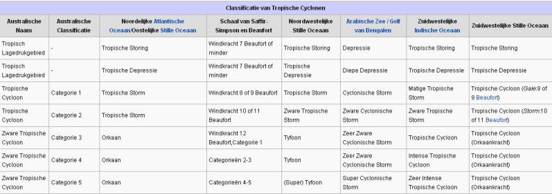
TIP: Interactief (film)overzicht van de krachten van orkanen n.a.v. de schaal van Simpson
Waarom hebben orkanen namen?
De Tropische Depressies worden overal ter wereld in de gaten gehouden en zodra de depressies uitgroeien tot orkaan of cycloon, wordt er een naam aan de storm gegeven. Sinds 1950 krijgen ze namen op alfabetische volgorde (met uitzondering van de letters Q, U, X, Y en Z). Mocht een orkaan vernietigend hebben huisgehouden zoals Floyd, Gilbert en bijv. Katrina, dan zal die naam worden vervangen. Soms komt het ook voor dat alle letters van het alfabet gebruikt zijn in één seizoen (zoals 2005), dan zal een volgende storm Alpha gaan heten, gevolgd door Beta etc etc. Voor het orkanenseizoen 2010 zijn de namen als volgt:
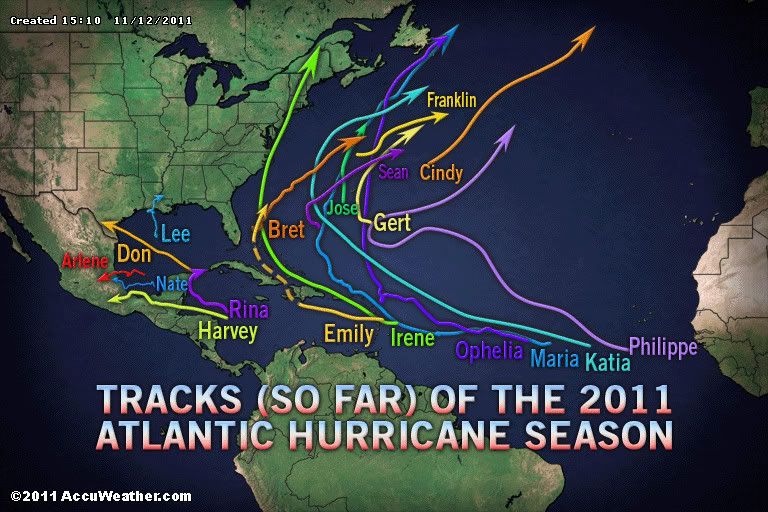
Atlantische Stormen 2011
Arlene, Bret, Cindy, Don, Emily, Franklin, Gert, Harvey, Irene, Jose, Katia, Lee, Maria, Nate, Ophelia, Philippe, Rina, Sean, Tammy, Vince, Whitney
In het Noordoosten van de Pacific ontstaan ook orkanen. Deze orkanen zorgen vaak voor overlast in Midden-Amerika en delen van Mexico.
Oost Pacifische Stormen 2011
Adrian, Beatriz, Calvin, Dora, Eugene, Fernanda, Greg, Hilary, Irwin, Jova, Kenneth, Lidia, Max, Norma, Otis, Pilar, Ramon, Selma, Todd, Veronica, Wiley, Xina, York, Zelda
Verder zijn er dan nog de stormen in het Noordenwesten, Midden en Zuiden van de Pacific. Daar worden ze tyfoons en/of cyclonen genoemd. Vooral de stormen in het Noord/Westen komen vaak in het nieuws omdat ze Japan, de Filippijnen, Taiwan en China vaak teisteren, maar ook geheel Zuid Oost Azië kunnen treffen. Ook in de Indische oceaan komen ze voor, daar zijn vaak Bangladesh en Myanmar aan de beurt, maar soms ook India, Pakistan of zelfs Oman.
Meer informatie over de namen van orkanen vind je hier.
Leuk hoor allemaal, maar wanneer zijn die orkaanseizoenen nou precies?
ATLANTISCHE OCEAAN: 1 juni t/m 30 november
NOORD OOST PACIFIC:Begin mei t/m begin november, met piek in augustus/september
NOORD WEST PACIFIC: Begin juli t/m eind november, maar eigenlijk hele jaar door activiteit.
NOORD INDISCHE OCEAAN: april t/m december met pieken in mei en november
ZUID INDISCHE + WEST AUSTRALISCHE OCEAAN: oktober t/m mei met pieken in februari en april
ZUID WEST PACIFIC + OOST AUSTRALISCHE OCEAAN: oktober tot eind april met piek in februari.
Over het algemeen is Mei de rustigste maand en September de zwaarste.
En? Zijn er al verwachtingen en/of voorspellingen voor 2011?
Begin december kwamen de eerste voorspellingen voor 2011 naar buiten. Ze verwachten wederom een zeer actief seizoen. 50 jaar orkaangeschiedenis heeft een zogenaamd gemiddeld orkaanseizoen gecreëerd. Namelijk: 9,6 stormen met naam, 5,9 groeit uit tot orkaan en 2,3 worden superorkanen (cat 4 of 5) Volgens de december verwachting krijgen we 17 tropische stormen in de Atlantische Oceaan. Negen groeien daarvan uit tot orkaan en vijf daarvan zullen superorkanen worden. Er is een kans van 73% dat één van deze 5 superorkanen de kust van de VS zal gaan treffen. Deze voorspelling kan je hier nog eens nalezen.
Waait het nou echt zo hard bij zo'n orkaan?
Oude Delen
2004 - Deel 1 en Deel 2
2005 - Deel 1 en Deel 2
2006 - Deel 1 en Deel 2
2007 - Deel 1, Deel 2, Deel 3 en Deel 4
2008 - Deel 1 en Deel 2
2009 - Deel 1 en Deel 2
2010 - Deel 1 , Deel 2 . Deel 3 en Deel 4
2011 - Deel 1 Deel 2[/url , [url=http://forum.fok.nl/topic/1698378]Deel 3
Enkele Links
1. National Hurricane Centre
2. Carribean Storm Network
3. Hurricanezone
4. Hurricane Track
5. Website met satelietbeelden van de Caribbean en de rest van Amerika
6. Intellicast: Geavanceerde satellietfoto's en gifs van aktuele stormen
7. Tropical Weather Underground
8. Tropical Storm Risico's van dit moment
9. Wikipedia Hurricanes/Tyfonen in het algemeen
10. Alle stormen ter wereld van de laatste jaren in overzicht
11. The StormTrack
12. Orkanensite in de Filipijnen
13. Atlantische Orkanensite
14. Actuele orkanen in Australië en De orkaanindeling in Australië
15. Tropische weersite omgeving Australië
16. Mooie site over Orkanen aan de VS kusten
17. Website van NASA over Hurricanes
18. Windrapporten wereldwijd
19. Storm2k - Amerikaans weerforum
Opmerkelijke Wikipedia-Links
-- Hurricane Katrina 2005
-- Cyclone Nargis 2008
-- Hurricane Season 2011 - Wikipedia
-- Hurricane Season 2010 - Wikipedia
-- Hurricane Season 2009 - Wikipedia
-- Hurricane Season 2008 - Wikipedia
-- Hurricane Season 2007 - Wikipedia
-- Hurricane Season 2006 - Wikipedia
-- Hurricane Season 2005 - Wikipedia
-- Hurricane Season 2004 - Wikipedia
Actuele Weerradar in Golf van Mexico

Actuele Water temperatuur.

=====================
Heb je informatie over orkanen of wil je gewoon alle orkanen van 2011 volgen, volg dan dit topic
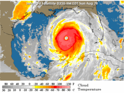
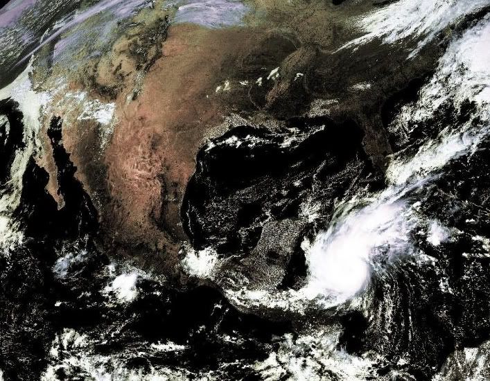
Fuck zeg... dat ding wordt ook gewoon een major Hurricane... en dat gebied is net al van de week onder water gezet door de vorige orkaan
quote:Massale evacuatie wegens tyfoon China
PEKING (ANP) - De tyfoon Nesat heeft donderdag het Chinese toeristeneiland Hainan bereikt. waar circa 100.000 mensen zijn geëvacueerd. De tyfoon had eerder huisgehouden op de Filipijnen, waar het minstens 35 levens heeft geëist.
De tyfoon is de krachtigste die China tot dusver dit jaar heeft bereikt. Het noodweer gaat gepaard met windsnelheden tot 151 kilometer per uur, meldde het meteorologisch bureau van Hainan. In het gebied is watersport en bergbeklimmen verboden tijdens de komende feestdagen, aldus Chinese media.
En de volgende orkaan, Nalgae dus, gaat exact dezelfde gebieden onder water zettenquote:Tyfoon Nesat eist zeker 35 mensenlevens op Filipijnen
De doortocht van de tyfoon Nesat over de Filipijnen dinsdag, heeft aan minstens 35 mensen het leven gekost. Dat blijkt uit de nieuwste balans die de autoriteiten donderdag meedeelden. De tol kan nog oplopen, want er zijn nog 45 vermisten.
De meeste vermisten zijn vissers die ondanks de waarschuwingen van de meteorologische dienst toch uitvoeren.
Nesat trof dinsdag de noordoostelijke kusten van Luzon, het grootste eiland van de Filipijnen waar meer dan de helft van de 90 miljoen inwoners van het land wonen. De windsnelheden tot 170 kilometer per uur en de hevige regenval hebben zware schade veroorzaakt.


En die kregen eerder ook al Talas te verwerken.quote:Op donderdag 29 september 2011 11:58 schreef Frutsel het volgende:
[ afbeelding ]
Fuck zeg... dat ding wordt ook gewoon een major Hurricane... en dat gebied is net al van de week onder water gezet door de vorige orkaan
Ceterum censeo Turciam delendam esse.
Kunnen ze straks dat stukje land weghalen en zee van maken op google mapsquote:
[..]
En die kregen eerder ook al Talas te verwerken.

Leuk voor al die mensenquote:
[..]
Kunnen ze straks dat stukje land weghalen en zee van maken op google maps
Wundergroundquote:Typhoon Nesat battering China
Typhoon Nesat hit China's Hainan Island today as a Category 1 typhoon with 75 mph winds. While Nesat's winds and storm surge will not cause major damage, it is a very wet storm, capable of dropping up to 8 inches of rain in 24 hours, according to latest satellite rainfall forecasts. Haikou on Hainan Island recorded a wind gust of 78 mph and 3.23" of rain as the eyewall passed just to the north. Nesat will hit Vietnam near Hanoi as a tropical storm on Saturday.
Nesat roared across Luzon Island in the Philippines Monday as a powerful Category 3 typhoon with 120 mph winds, leaving 35 people dead and 45 missing. The Philippines has a new worry today: Typhoon Nalgae has formed 700 miles to the east of Luzon Island, and is expected to follow a course just to the north of Nesat's. Nalgae is expected to intensify into a major Category 3 typhoon and hit the northern portion of Luzon on Saturday afternoon, local time. With soils on the island already saturated from the heavy rains Nesat brought, the new typhoon promises to bring heavy flooding to Luzon this weekend.
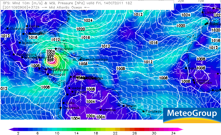
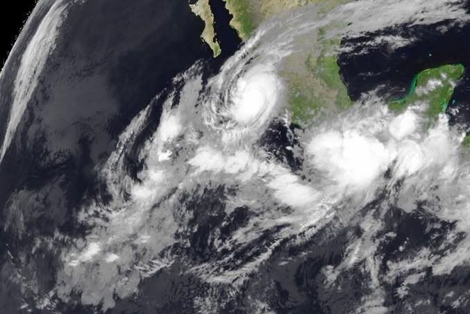
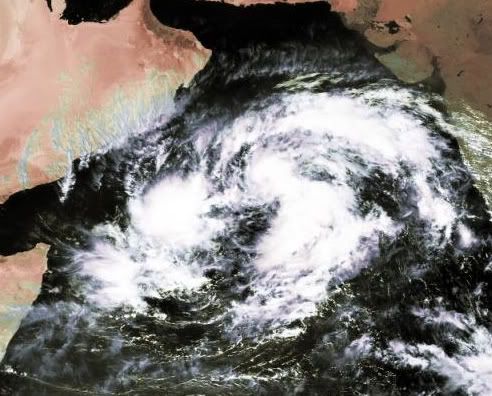
Zou dat Philippe zijn?quote:Op donderdag 29 september 2011 19:43 schreef aloa het volgende:
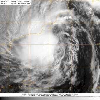
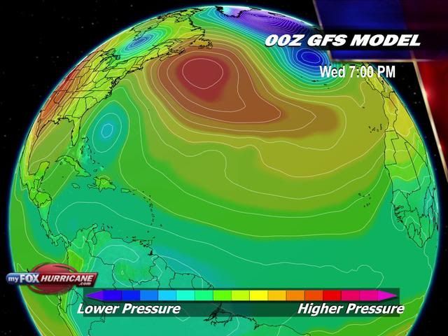
Nog ver weg dit, maar GFS laat al een paar dagen een orkaan zien in de Caribische zee.
[ afbeelding ]
Volgens meerdere modellen gaat hij straks richting zuidwesten
quote:Nieuwe orkaan op weg naar Groot-Brittanië
Het was gisteren in het zuiden van Engeland de warmste 2 oktober in meer dan 100 jaar. In het noorden van het land en de rest van Groot-Brittannië moesten ze echter de paraplu bovenhalen. En alsof dat nog niet genoeg is, moet de regio zich schrap zetten voor een nieuwe orkaan.
Een paar weken geleden kreeg Groot-Brittannië het bezoek van orkaan Katia. In de loop van deze week zullen Schotland, Noord-Ierland en het noorden van Engeland de restanten van orkaan Ophelia over zich heen krijgen. De staart van de storm ligt momenteel nog in de buurt van Noord-Amerika.
Het contrast kan dan ook niet groter zijn in Groot-Brittannië. Net als wij geniet Engeland al meer dan een week van uitzonderlijk zomers weer. De temperatuur ligt er al dagen rond 25 graden Celsius. In Norfolk haalde het kwik gisteren zelfs een recordtemperatuur van 29,3 graden. Het vorige record lag meer dan een graad lager en dateert al van 1908.
Ter vergelijking, het noorden van Engeland en Schotland zagen het kwik niet hoger stijgen dan 15 graden. En deze week wordt het er nog kouder. Uiteindelijk zullen de temperaturen ook in het zuiden terugvallen naar waarden die onder het gemiddelde liggen. "We zullen een echt herfstgevoel krijgen, zelfs een beetje winters in Schotland", zegt de Britse weerkundige dienst. Ook bij ons wordt het de komende dagen heel wat koeler. Nog een dagje genieten dus...
Ik denk dat orkaankracht er niet meer in zit. Waarschijnlijk zal het niet meer dan een 10 beaufort worden. Wat nog altijd veel wind is en voor schade kan zorgen.quote:
In de oost pacific een gevaar voor Mexico.
[ Bericht 0% gewijzigd door #ANONIEM op 06-10-2011 12:56:42 ]

[ Bericht 0% gewijzigd door #ANONIEM op 06-10-2011 12:56:42 ]
twitter:wunderground twitterde op donderdag 06-10-2011 om 16:14:18 We are monitoring the possibility of a tropical/subtropical system near FL early next week reageer retweet
Dit was de voorspelling
tot nu toe hebben we dit:
Total depressions: 17
Total storms: 16
Hurricanes: 5
Major hurricanes (Cat. 3+): 3
[ Bericht 24% gewijzigd door #ANONIEM op 08-10-2011 09:23:34 ]

tot nu toe hebben we dit:
Total depressions: 17
Total storms: 16
Hurricanes: 5
Major hurricanes (Cat. 3+): 3
[ Bericht 24% gewijzigd door #ANONIEM op 08-10-2011 09:23:34 ]

Thanks! Mooi op schema lijkt hetquote:
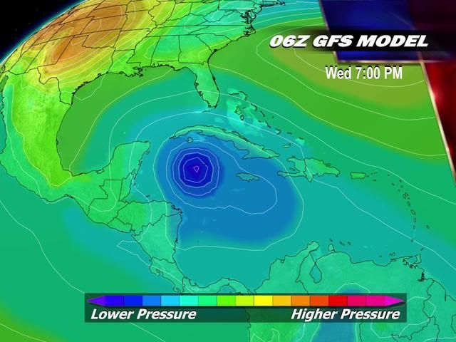
Dit was de voorspelling
[ afbeelding ]
tot nu toe hebben we dit:
Total depressions: 17
Total storms: 16
Hurricanes: 5
Major hurricanes (Cat. 3+): 3
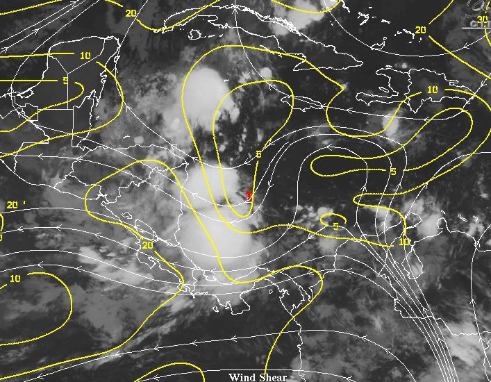
Het ziet er momenteel rustig uit. 30% bij Florida en PHILIPPE is er nog, maar verder lijkt er niet veel bijzonders te ontstaan. Op de hele lange termijn lijkt er iets te ontstaan in de Caribische zee, maar dat is niet betrouwbaar. (nog niet!)quote:

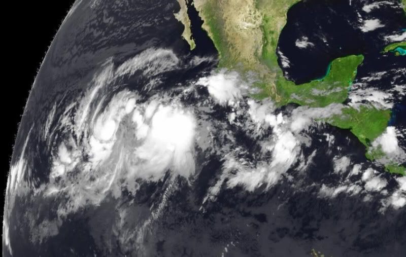
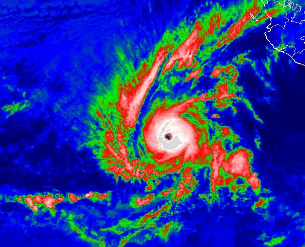
GOES-15 10.7 µm IR images (above; click image to play animation) showed a large area of very cold cloud top IR brightness temperatures associated with Tropical Storm Jovi over the East Pacific Ocean on 07 October 2011. Embedded within the large region of cloud top IR temperatures colder than -80º C (light purple color enhancement) were smaller areas that exhibited cloud top IR temperatures of -90º C or colder (dark purple color enhancement) — and the coldest cloud top IR brightness temperature seen was -94.65º C at 09:30 UTC. It is unusual to see cloud top IR brightness temperatures of -90º C or colder on 4-km resolution GOES IR imagery.
Note that GOES-15 is scheduled to replace GOES-11 as the operational GOES-West satellite in December 2011.
http://cimss.ssec.wisc.edu/goes/blog/
Ok, de top van dat systeem was dus erg koud, maar wat betekend dat? En wat is normaal? Jammer dat het blog daar niks over zegt (of linkt).
Heeft het niet met de hoogte van wolkentoppen te maken? Jammer inderdaad dat ze dat er dan niet bij vermelden.quote:
Ok, de top van dat systeem was dus erg koud, maar wat betekend dat? En wat is normaal? Jammer dat het blog daar niks over zegt (of linkt).
quote:Aan de bovenkant van de orkaan spiraliseert de lucht vervolgens weer naar buiten en daalt daarbij op grotere afstand van het oog weer naar zeeniveau. Door de permanente uitstraling naar het heelal, de witte wolken van de buientoppen reflecteren vrijwel alle zonnestraling, wordt de temperatuur van de buientoppen constant op -55 tot -60 graden gehouden.
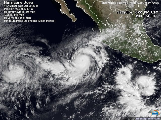
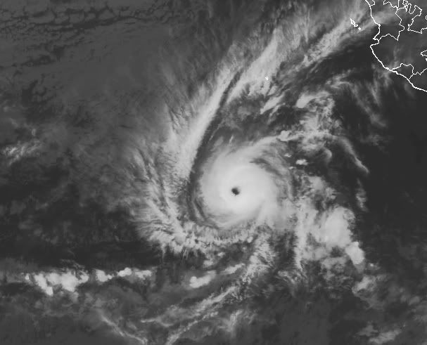
JOVA gaat nog een categorie 4 worden ook.
Momenteel een windsneleheid van 193 km/uur met windstoten tot 241 km/uur.
De orkaan beweegt zich voort met een snelheid van 6 km/uur, de kerndruk is 960 mb.
Inmiddels is er voor een groot gebied een orkaanwaarschuwing uitgegeven.
Momenteel een windsneleheid van 193 km/uur met windstoten tot 241 km/uur.
De orkaan beweegt zich voort met een snelheid van 6 km/uur, de kerndruk is 960 mb.
Inmiddels is er voor een groot gebied een orkaanwaarschuwing uitgegeven.
Eindelijk een verlichtend buitje voor het record droge Mexico en Texas zo te zien. Ze zullen er blij mee zijn.quote:
JOVA gaat nog een categorie 4 worden ook.
Momenteel een windsneleheid van 193 km/uur met windstoten tot 241 km/uur.
De orkaan beweegt zich voort met een snelheid van 6 km/uur, de kerndruk is 960 mb.
Inmiddels is er voor een groot gebied een orkaanwaarschuwing uitgegeven.
Texas gaat er niet veel van meekrijgen.quote:
[..]
Eindelijk een verlichtend buitje voor het record droge Mexico en Texas zo te zien. Ze zullen er blij mee zijn.
Oh, nou dat zou voor de beleving van de gemiddelde Amerikaan wel eens gunstig kunnen zijn (ik bedoel: laat ze daar nog maar even in de droogte zitten en nog wat records breken). Shocktherapie Is goed voor hun gewaarwording...quote:
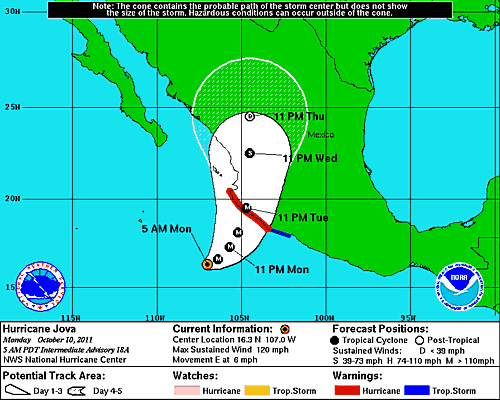
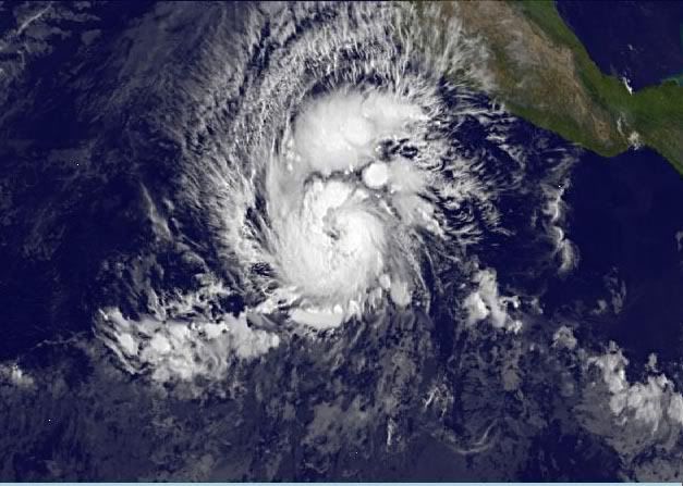
Nieuw syteem voor Mexico en Guatemala. Het lijkt erop dat dit geen orkaan gaat worden, maar zal wel voor veel neerslag gaan zorgen.
quote:JOVA kills four in Mexico
At least four people were killed on Wednesday when Hurricane Jova made landfall in western Mexico, officials said. The storm has since weakened to a tropical depression.
All four deaths were reported in the state of Jalisco where Jova made landfall on late Tuesday evening with maximum sustained winds near 100 miles (160 kilometers) per hour, making it a category two hurricane on the five-step Saffir-Simpson scale of intensity.
Two fatalities were reported in the municipality of Cihuatlan where a house collapsed, killing a 21-year-old woman named Norma Irene Rebolledo and her 5-year-old daughter Yolanda Marisol Rebolledo. Cihuatlan is located on the southern coast of Jalisco.
Two other fatalities were reported in the Jose Maria Morelos community, located in the municipality of Tomatlan, where a landslide killed a woman and her 13-year-old son. Tomatlan is located in the northern part of Jalisco.
Access to several communities, including Cihuatlan, La Huerta, Villa Purificacion, Autlan and Cuautitlan de Garcia Barragan was cut off due to water overflowing from the Marabasco River and at least ten connecting creeks.
In Cihuatlan alone, around 5,000 people have been displaced, the municipality’s Secretary General Fermin Alvarez Zamora said. As of Wednesday, more than 1,500 people were living at 70 temporary refugee camps which have been set up in the north and southern regions of Jalisco.
State Civil Protection emergency teams used helicopters to rescue at least 19 people in the affected areas, and it was not immediately clear if the death toll could still rise. Officials said electricity was knocked out in several parts of the states of Jalisco, Colima, Michoacan, Nayartit, and Sinaloa, affecting some 107,000 people.
As of Wednesday afternoon, Jova was located about 20 miles (35 kilometers) east-southeast of Tepic, the capital and largest city of the Mexican state of Nayarit. The system has weakened to a tropical depression with maximum sustained winds near 35 miles (55 kilometers) per hour, with higher gusts.
“Joda has weakened significantly during the past several hours,” said Jack Beven, a senior hurricane specialist at the U.S. National Hurricane Center (NHC). “The central convection has completely dissipated, there are no surface observations of tropical-storm-force winds, and [recent data] showed no tropical-storm-force winds over water west of the center. It is estimated that the cyclone has weakened to a tropical depression, although some gusts to tropical-storm-force are possible in mountainous areas for the next few hours.”
He added: “Although Jova has weakened, inland flooding over Mexico will remain a major concern. Heavy rains due to Jova are likely to continue across portions of western Mexico due to the relatively slow movement of the cyclone and upslope flow into the mountainous terrain. These rains will likely cause dangerous flash floods and mud slides.”
Jova is the ninth named storm of the 2011 Eastern Pacific hurricane season. It was followed by Hurricane Irwin which remains active as a tropical storm, about 415 miles (670 kilometers) south of the southern tip of Baja California, and the system could affect the same area as Jova on Thursday.
According to figures released in May, NOAA’s Climate Prediction Center is expecting a below normal hurricane season in the Eastern Pacific this year. The outlook calls for 9 to 15 named storms, with five to eight becoming hurricanes and one to three expected to become a major hurricane (category 3 or higher).
An average Eastern Pacific hurricane season produces 15 to 16 named storms, with eight to nine becoming hurricanes and four becoming major hurricanes. The Eastern Pacific hurricane season runs from May 15 through November 30, with peak activity from July through September.
quote:Negen doden bij nieuwe tropische storm op de Filipijnen
Bij een nieuw storm op de Filipijnen zijn in het centrum en het zuiden van het land zeker negen mensen om het leven gekomen. Dat heeft de civiele bescherming vandaag meegedeeld. Meer dan 23.000 mensen zijn getroffen door tropische storm Banya, die gisteren aan land kwam.
Volgens de civiele bescherming zijn duizenden reizigers gestrand door het stilleggen van het scheepsverkeer en de annulering van 48 binnenlandse vluchten. Verwacht wordt dat de storm komend weekend over de noordwestelijke provincies en hoofdstad Manila trekt.
Twee weken geleden kwamen 101 mensen om het leven nadat twee tyfoons vlak na elkaar over het noorden en oosten van de Filipijnen waren getrokken. (afp/adv)

Tientallen doden door noodweer Midden-Amerika
PANAMA-STAD (ANP) - Hevig noodweer heeft binnen een etmaal aan meer dan 20 mensen het leven gekost in Guatemala, Nicaragua en El Salvador. Ook Costa Rica en Honduras zijn getroffen door overstromingen.
Dit is woensdag (plaatselijke tijd) vernomen van de autoriteiten van de Midden-Amerikaanse landen. Het zwaarst getroffen is Guatemala, waar zeker 16 doden vielen, onder wie 4 kinderen. Duizenden mensen moesten worden geëvacueerd.
Elsevier
@Accuweatherquote:Deadly Week in the Tropics
It has been a deadly week with Hurricane Jova and once-Tropical Storm Banyan slamming onshore and a short-lived tropical depression unleashing flooding rain.
At the end of Wednesday, Jova was responsible for claiming at least five lives across western Mexico as the depression (T.D. 12-E) took 13 lives in Guatemala.
At least six lives were lost when once-Tropical Storm Banyan slammed the Philippines Monday into Wednesday.
Most of deaths from Jova and T.D. 12-E were at the hands of torrential rain, according to the Associated Press.
Jova's heavy rain drenched western Mexico late Tuesday into Wednesday. More than 11 inches of rain inundated Manzanillo with nearly 14 inches in the neighboring city of Colima.
The inundation triggered flooding and mudslides. One such mudslide in the town of Cihuatlan swept away a home along a hillside, killing a young woman and her daughter.
Also in Cihuatlan, 4 feet of flood waters filled a Red Cross office and forced evacuations.
The Associated Press reports that two other people died after being crushed by a wall of their home in the town of Tomatlan. Jova's rain had softened the wall, leading to its collapse.
Jova officially made landfall near the town of Chamela in the western Mexican state of Jalisco around 11 p.m. Tuesday (PDT, 2 a.m. EDT Wednesday).
A Category 2 hurricane, Jova was producing maximum sustained winds of nearly 100 mph at that time.
Soon after Jova came onshore, Tropical Depression 12-E took shape in the Gulf of Tehuantepec (offshore of southeastern Mexico).
The depression would move inland and weaken to a tropical rainstorm less than 24 hours later, but it had enough time to turn deadly as its heavy rain streamed into southeastern Mexico and neighboring Guatemala.
Guatemalan President Alvara Colom told the Associated Press that at least four of the 13 people that died in his country were electrocuted. Others died in mudslides and raging rivers.
Tapachula, the Mexican city located near the southern border of Guatemala, picked up nearly 4 inches of the depression's rain in 24 hours, ending late Wednesday.
The good news is that the tropical eastern Pacific is much quieter than at this time Wednesday. Irwin is the only tropical system still roaming the waters of the eastern Pacific and will continue to weaken today.
The Atlantic Basin remains void of organized tropical systems, but the AccuWeather.com Hurricane Center is monitoring the potential for that to change next week.
quote:16 killed in Guatemala
At least sixteen people were killed on Wednesday when torrential rains from a tropical depression hit several regions of Guatemala, officials said. The death toll is expected to rise.
Tropical Depression 12-E formed near the Mexico-Guatemala border on early Wednesday morning, about 150 miles (240 kilometers) southeast of Salina Cruz in Mexico, triggering Guatemala’s National Disaster Reduction Coordination Center to activate a nationwide red alert.
The heavy rainfall began on Tuesday night and continued into Wednesday, causing landslides, overflowing rivers, and accidents. The depression is expected to weaken and dissipate on Wednesday evening, forecasters said, but the harsh weather is expected to continue into Thursday.
Among the 16 confirmed deaths in Guatemala, four were electrocuted and one was buried in the municipality of Almolonga in the Quetzaltenango department. Several others died after their homes collapsed, while rescue workers recovered a couple of bodies from a river in Chiquimulilla, a municipality in the Santa Rosa department.
The most affected regions include Quetzaltenango, Santa Rosa, Jutiapa, and Totonicapan, as well as other scattered areas in the country. More than 130,000 people in Guatemala have been affected by the severe weather, but there were no immediate reports of casualties from Mexico.
Guatemalan President Alvaro Colom, who offered his condolences, has called on residents around the country to be extra careful.
Tropical Storm Possible in Gulf This Week
A large area of rain and thunderstorms near the Yucatan Peninsula may become the next tropical storm of this season. Despite uncertainty on the exact development, heavy rain is likely heading toward Florida.
An area of low pressure, a good indicator for possible tropical development, will park itself over the Yucatan through Monday. The low may have a tough time organizing into a tropical depression or storm this week given its close proximity to land. However, warm water across the Gulf of Mexico may be enough to foster tropical development.
No matter what comes of this potential tropical development, it seems heavy rain will target the Southeast, especially Florida, by the middle of this week.
"Regardless of which scenario pans out, much of the Florida peninsula may receive 2 to 4 inches of rain, with locally higher amounts," said Senior Meteorologist Danny Pydynowski.
The leading edge of a widespread heavy rain for Florida could move in as soon as Tuesday and persist into Wednesday.
Although a developing tropical system will remain a concern this week, the peak intensity would likely be a tropical storm. There are no significant indicators that a hurricane is plausible.
Some of the tropical moisture associated with the area of concern near the Yucatan may get pulled into the "wild" storm headed for the Northeast Wednesday.
@Accuweather
A large area of rain and thunderstorms near the Yucatan Peninsula may become the next tropical storm of this season. Despite uncertainty on the exact development, heavy rain is likely heading toward Florida.
An area of low pressure, a good indicator for possible tropical development, will park itself over the Yucatan through Monday. The low may have a tough time organizing into a tropical depression or storm this week given its close proximity to land. However, warm water across the Gulf of Mexico may be enough to foster tropical development.
No matter what comes of this potential tropical development, it seems heavy rain will target the Southeast, especially Florida, by the middle of this week.
"Regardless of which scenario pans out, much of the Florida peninsula may receive 2 to 4 inches of rain, with locally higher amounts," said Senior Meteorologist Danny Pydynowski.

The leading edge of a widespread heavy rain for Florida could move in as soon as Tuesday and persist into Wednesday.
Although a developing tropical system will remain a concern this week, the peak intensity would likely be a tropical storm. There are no significant indicators that a hurricane is plausible.
Some of the tropical moisture associated with the area of concern near the Yucatan may get pulled into the "wild" storm headed for the Northeast Wednesday.
@Accuweather
quote:Tientallen doden door noodweer Midden-Amerika
SAN SALVADOR - Tientallen mensen zijn in Midden-Amerika omgekomen bij overstromingen en aardverschuivingen veroorzaakt door zes dagen van zware regenval. Dat hebben de autoriteiten gezegd. Er is meer regen op komst.
Tientallen doden door noodweer Midden-Amerika
In El Salvador kwamen 24 mensen om toen hun huizen werden bedolven door aardverschuivingen. Mensen die op de flanken van de vulkaan San Salvador wonen zijn geëvacueerd, aldus een regeringswoordvoerder. In 1982 kostten aardverschuivingen daar aan honderden mensen het leven.
In Guatemala, waar zeker 23 mensen zijn omgekomen, heeft de president de noodtoestand uitgeroepen. In Honduras kwamen negen mensen om en zijn meer dan duizend mensen geëvacueerd. In Nicaragua, waar de regen inmiddels afneemt, kostte het noodweer aan vijf mensen het leven.

60% inmiddelsquote:
Tropical Storm Possible in Gulf This Week
@Accuweather

Dit kan wel een gevaarlijk systeem worden in de Caribische zee. 30% nu, maar deze maakt wel kans op orkaankracht.
[ Bericht 37% gewijzigd door #ANONIEM op 21-10-2011 14:31:28 ]
[ Bericht 37% gewijzigd door #ANONIEM op 21-10-2011 14:31:28 ]

Weinig windshear, waardoor het systeem zich goed kan ontwikkelen.
Watertemperatuur ligt rond de 30 graden.
Watertemperatuur ligt rond de 30 graden.
Western Caribbean disturbance 96L growing more organized
A region of disturbed weather in the Western Caribbean (Invest 96L) is bringing heavy rains to coastal Nicaragua, and has the potential to develop into a tropical depression this weekend. Visible satellite loops show that 96L is beginning to show signs of organization. Some rotation is apparent, and the upper-level cirrus clouds streaming away from the center indicate that 96L is establishing an upper-level outflow channel to the east. The heavy thunderstorm activity is quite limited at present, because a large region of dry air to the east of 96L is interfering with development, as seen on water vapor satellite loops. An ASCAT pass at 11:05 am EDT showed no signs of a surface circulation, with surface winds in the 25 - 30 mph range. Surface pressures are slowly falling at San Andres Island, near the center of 96L. Wind shear is a moderate 10 - 20 knots in the region, and is expected remain in the moderate range through Monday. Water temperatures are very warm, 29 - 30°C, and these warm waters extend to great depth.
Forecast for 96L
The moderate wind shear and warm waters should allow some modest development of 96L over the next few days, though this will be slowed by the dry air to the storm's east. The models are quite enthusiastic about developing 96L into a tropical depression, and our top four reliable models for forecasting genesis--the ECMWF, GFS, UKMET, and NOGAPS--have all been predicting formation of a tropical depression by Monday in one or more of their runs over the past day. 96L is in an area of weak steering currents, and will move little over the next three days. On Tuesday and Wednesday, a strong trough of low pressure will be passing over the Eastern U.S., and this trough has the potential to turn 96L northwards into Cuba. This is more likely to happen if 96L is stronger and deeper, and thus able to "feel" the upper-level winds the trough will bring. The 12Z run of the GFS model and 00Z runs of the ECMWF and UKMET models predict 96L will develop into a tropical storm that hits Western Cuba on Wednesday or Thursday, and potentially affecting the Cayman Islands, South Florida, and the Bahamas as well. If 96L remains a weak and shallow system, it is more likely to stay trapped in the Western Caribbean and make landfall in Nicaragua. This is the solution of the NOGAPS model, which has 96L moving ashore on Tuesday over Nicaragua as a weak system. NHC gave 96L a 30% chance of developing into a tropical depression by Sunday in their 8 am Tropical Weather Outlook. A hurricane hunter mission is scheduled to investigate 96L Saturday afternoon.
I'll have a new post on Saturday, but might wait until the afternoon, when the hurricane hunter data becomes available.
Jeff Masters
70%
quote:. THUNDERSTORM ACTIVITY HAS INCREASED AND BECOME CONCENTRATED DURING
THE PAST SEVERAL HOURS NEAR THE CENTER OF A LOW PRESSURE AREA IN
THE SOUTHWESTERN CARIBBEAN SEA...LOCATED ABOUT 150 MILES MILES
EAST-SOUTHEAST OF THE NICARAGUAN/HONDURAN BORDER. ENVIRONMENTAL
CONDITIONS ARE GRADUALLY BECOMING MORE CONDUCIVE FOR DEVELOPMENT...
AND A TROPICAL DEPRESSION COULD FORM LATER TODAY OR TONIGHT. THIS
SYSTEM HAS A HIGH CHANCE...70 PERCENT...OF BECOMING A TROPICAL
CYCLONE DURING THE NEXT 48 HOURS AS IT MOVES SLOWLY NORTHWARD AND
THEN NORTHWESTWARD. REGARDLESS OF DEVELOPMENT...LOCALLY HEAVY RAINS
AND GUSTY WINDS SHOULD CONTINUE TO AFFECT PORTIONS OF HONDURAS AND
NICARAGUA THROUGH MONDAY. AN AIR FORCE RESERVE HURRICANE HUNTER
AIRCRAFT IS SCHEDULED TO INVESTIGATE THIS DISTURBANCE THIS
AFTERNOON...IF NECESSARY.


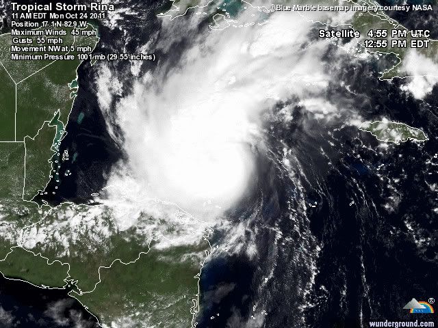
quote:TS RINA FACES SERIOUS OBSTACLES- IF IT OVERCOMES THEM, IT COULD BE A REAL PROBLEM
It was exactly six years ago today that we were in the midst of dealing with a powerful hurricane Wilma as it tore through south Florida. At one point, Wilma was the most intense Atlantic hurricane ever recorded. It went on to deal a significant punch to portions of the Yucatan peninsula before moving northeast and in to south Florida where it knocked out power for at least 6 million people, some until near Thanksgiving of that year. My point is- this time of year is climatologically favorable for strong Caribbean hurricanes that can reach land, including Florida. Now, six years later, we have tropical storm Rina in a similar position as Wilma was, tucked in to the northwest Caribbean Sea. Will the final outcome be just as similar or vastly different? Let's take a look at what we know.
First off, the NHC is forecasting Rina to become a hurricane as it approaches the northeast Yucatan later this week. Water temperatures in the region are very warm as is the heat content value. In other words, the water is not only warm at the surface, but also quite deep below the surface so that as the ocean is churned up, more warm water comes to the surface, not cooler water. This provides an incredible amount of heat energy for torpical cyclones and Rina could take advantage of this. On the other hand, there is an obvious lack of vertical instability across the region due to dry air in the atmoshphere. Tropical cyclones need very unstable and moist air to generate the powerful upward motion that leads to convection or thunderstorm activity. I would say that dry air is perhaps a more prolific killer of hurricanes than any other factor. Cold water is a slow process as it has to slowly eat away at away at the energy source. Dry air, especially that is entrained within the circulation itself, can literally deflate a tropical cyclone in a matter of hours, sometimes less. Think back to Irene. It was forecast by some to become an intense hurricane off the North Carolina coast. Instead, dry mid-level air became pulled in to the circulation and down the convection went. Irene never recovered. The NHC mentions this dry air in their latest discussion and if Rina gets involved with that, it will almost certainly mean it cannot strengthen much at all.
On the other hand, if Rina is able to fight off the dry air and create its own moist environment, taking advantage of the very warm water across the region, it could intensify fairly substantially. For what ever reason, this is what the GFDL and HWRF models indicate as both predict a very strong hurricane to materialize. Conversely, the SHIPS intensity model, which is not as robust or dynamic as the GFDL and HWRF models, only shows modest strengthening but not even to hurricane status. Regardless, the NHC's official forecast shows 75 mph in about four days. It is possible that Rina never makes it to that intensity but I caution you too that it is also possible for Rina to be considerably stronger. Remember that intensity forecasts are notoriously prone to errors. This is why it is important to always be ready when a tropical cyclone is heading your way. There was not one model that predicted Ophelia would become a category four hurricane way out in the open Atlantic at 33.8 degrees north latitude. Intensity forecasts were off by as much as 60 knots for Ophelia and it was over only barely warm enough water to even sustain itself. Odds are that Rina will succomb to the hostile October (and seasonal) environment that lies before it. This is not 2005 when everything was perfect from June through January of 2006. So far, the season has produced an overwhelming amount of stable air across much of the tropics. While this could change with Rina, there is little reason to doubt that it will right now.
As far as the track is concerned, a lot depends on intensity. Again, the GFDL and HWRF models show a strong, well developed hurricane coming out of the Caribbean and tracking in to south Florida. The NHC is not buying this scenario right now due to the limiting factors I mentioned above. The global models, specifically the GFS and ECMWF show no impact to Florida. However, interests along the eastern coast of the Yucatan need to follow Rina's progress closely. It is too soon to know with much certainty whether or not the storm will have a direct impact on the region but the current forecast indicates a possible landfall along the northeast coast in about five days. Obviously this can change, and probably will but for now, Rina is a possible threat to land. We'll know more as each day passes and we see how the steering and intensity situation plays out. I wll be very interested to see if the hurricane specific models, the GFDL and HWRF, are correct or if they have lost touch with reality and come no where near being accurate with this situation. It will be an interesting week ahead to be sure.
 Op
Op 
Het is de vraag wat Rina gaat doen. Echt duidelijk is dat nog niet. De modellen weten het ook niet helemaal. GFS laat het systeem nu voor een lange tijd rondtollen in de Caribische Zee.
Rina is een tropische storm met een windsnelheid van 72 km/uur. Dit is te vergelijken met een windkracht 8 en bijna een stormkracht 9. De windstoten halen 88 km/uur. De verwachting is dat Rina langzaam in kracht zal toenemen en een categorie 1 zal worden.
Rina is een tropische storm met een windsnelheid van 72 km/uur. Dit is te vergelijken met een windkracht 8 en bijna een stormkracht 9. De windstoten halen 88 km/uur. De verwachting is dat Rina langzaam in kracht zal toenemen en een categorie 1 zal worden.
Rina:


quote:REPORTS FROM AN AIR FORCE RESERVE HURRICANE HUNTER AIRCRAFT INDICATE
THAT THE MAXIMUM SUSTAINED WINDS HAVE INCREASED TO NEAR 75 MPH...
120 KM/H...WITH HIGHER GUSTS. RINA IS A CATEGORY ONE HURRICANE ON
THE SAFFIR-SIMPSON HURRICANE WIND SCALE. ADDITIONAL STRENGTHENING
IS EXPECTED DURING THE NEXT 48 HOURS AND RINA IS FORECAST TO BECOME
A MAJOR HURRICANE BY LATE TUESDAY.
SATELLITE IMAGES AND REPORTS FROM AN AIR FORCE RESERVE HURRICANE
HUNTER AIRCRAFT INDICATE THAT RINA HAS RAPIDLY STRENGTHENED. THE
AIRCRAFT REPORTED PEAK 850 MB FLIGHT-LEVEL WINDS OF 68 KT AND
BELIEVABLE SFMR WINDS AROUND 65 KT. BASED ON THESE DATA THE
INITIAL INTENSITY IS INCREASED TO 65 KT...MAKING RINA THE 6TH
HURRICANE OF SEASON IN THE ATLANTIC BASIN. THIS SPECIAL ADVISORY
HAS BEEN ISSUED TO INCREASE THE INITIAL AND FORECAST INTENSITIES
FROM THE PREVIOUS FORECAST...BUT NO CHANGE TO THE TRACK WAS
REQUIRED.
Doe mee met het voorspellen van het weer!
Weekvoorspelling | Week 45 (invullen tot 3-11 11:59)
Maandvoorspelling November (Gesloten)
Jaarvoorspelling 2024 / 2025
Weekvoorspelling | Week 45 (invullen tot 3-11 11:59)
Maandvoorspelling November (Gesloten)
Jaarvoorspelling 2024 / 2025
Ja wie had dat even gedacht!quote:Op maandag 24 oktober 2011 21:37 schreef aloa het volgende:
[..]
Gaat nog een major hurricane worden ook.
Die Rina zal ons nu wel uitlachen
Doe mee met het voorspellen van het weer!
Weekvoorspelling | Week 45 (invullen tot 3-11 11:59)
Maandvoorspelling November (Gesloten)
Jaarvoorspelling 2024 / 2025
Weekvoorspelling | Week 45 (invullen tot 3-11 11:59)
Maandvoorspelling November (Gesloten)
Jaarvoorspelling 2024 / 2025
Lol pas maar op, Televaag heeft het over een "megaslechtweergebied"
http://www.telegraaf.nl/b(...)Cancn__.html?cid=rss
http://www.telegraaf.nl/b(...)Cancn__.html?cid=rss
Weer of geen weer, altijd actueel www.onweer-online.nl
Zal vanmiddag of vanavond nog wel naar 3 gaanquote:
Ben benieuwd of ze stand houdt na de landfall en dan afwachten wat er in de Golf nog van over is.
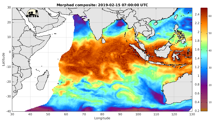
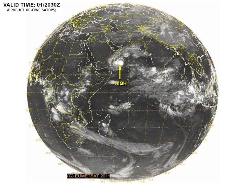
Voor de kust van Oman en Yemen. Ze gaan daar flink wat neerslag krijgen. Over een paar dagen lijkt zich nog een gebied te ontwikkelen aan de westkant van India.
Ben benieuwd, laatste jaren komt daar toch zeker wel een flinke orkaan vandaan.
Nu het Atlantische seizoen voorbij is zal daar de kern van activiteit wel liggen, net als bij Bangladesh enzo
Nu het Atlantische seizoen voorbij is zal daar de kern van activiteit wel liggen, net als bij Bangladesh enzo
Gemiddeld komt er 1 orkaan per jaar voor in de Arabische zee. In het gebied bij India en Bangladesch komen ze iets (maar ook niet veel) vaker voor.quote:
Ben benieuwd, laatste jaren komt daar toch zeker wel een flinke orkaan vandaan.
Nu het Atlantische seizoen voorbij is zal daar de kern van activiteit wel liggen, net als bij Bangladesh enzo
Ben benieuwd of dit doorzet.
Nargis (2008) was een april of mei storm dacht ik.. weet niet hoe erg november kan zijn daar. Maar het is wel de actiefste maand samen met mei
Tropical Cyclone Season Begins for Australia
The Australian tropical cyclone season has begun as of the first of November, and it will last through the end of April 2012.
Based upon the historical record, the season normally produces 12 tropical cyclones in the Australian region, according to the Australian Bureau of Meteorology (BoM). A plurality of storms live out their life cycle off northwestern Australian, sometimes making landfall on the rather sparsely settled coast.
Forecasters for the BoM have forecast an above-normal number of tropical cyclones for the 2011-12 season, with an 80 percent likelihood of occurrence. The neutral to borderline La Nina state of the tropical Pacific Ocean, during the Northern Hemisphere summer, was cited as favoring the above-normal storm count.
The sea-surface cooling that marks "La Nina" conditions in the tropical Pacific Ocean tends to boost tropical cyclone incidence in the Australian region.
Last season, there were 11 named tropical cyclones in the Australian region, of which five were rated a "Severe Tropical Cyclone."
The strongest storm was Severe Tropical Cyclone Yasi which, at its height, wielded a 130-mph fury. Yasi's landfall in northeastern Queensland led to one of the most costly storm aftermaths in Australia's history.
Accuweather
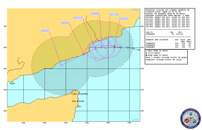
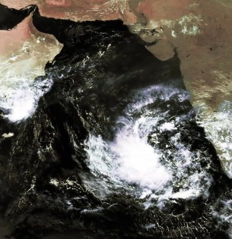
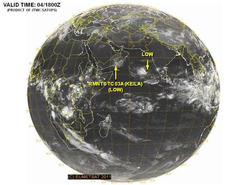
quote:Cyclone Keila soaking Arabia
Tropical Cyclone Keila, an unusual visitor to Arabia, will unleash drenching rain as it hovers near the south coast of Arabia for the next day or so.
Flash flooding will be the greatest storm threat to life and property, as Keila's moderate intensity will preclude widespread high winds over land.
In southwestern Oman, Keila has already triggered rainfall of 50 to 100 mm (2 to 4 inches) in the area of Salalah and the port of Raysut. This amount is comparable to a normal year's rainfall. What is more, as much more rain could pelt the area before the storm dissipates along the coast near the Oman-Yemen border.
Tropical cyclones are rare events along the coast of Oman and Yemen. When they have made landfall, they have historically triggered flash flashing, as happened with severe, destructive Tropical Cyclone Gonu in June 2007.
Another cyclonic storm struck Yemen from the Gulf of Aden in October 2008, resulting in severe flooding.
Nieuwe invest in de Arabische zee. Bij Jemen is nog het restant van Keila te zien.
Keila heeft voor 14 doden en 200 gewonden gezorgd in Oman. Er is een enorme hoeveelheid regen gevallen waardoor in sommige gebieden het water bijna 2 meter hoog staat.
Keila heeft voor 14 doden en 200 gewonden gezorgd in Oman. Er is een enorme hoeveelheid regen gevallen waardoor in sommige gebieden het water bijna 2 meter hoog staat.
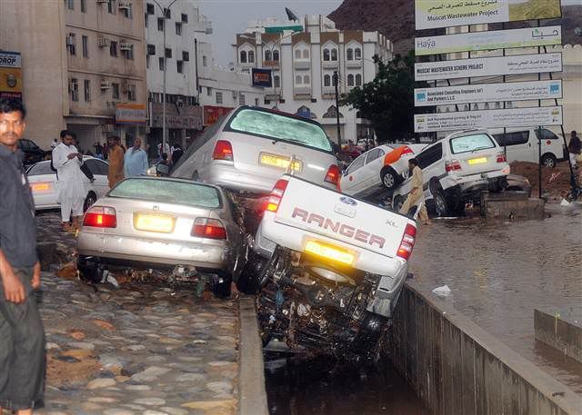
quote:MUSCAT, Oman — The death toll from a tropical storm that swept across Oman has risen to 14 with several bodies turning up in surging floodwaters, officials said on Thursday.
At least 200 people were injured in the cloudburst that lashed the largely desert sultanate on the eastern flanks of the Arabian Peninsula, a location that puts it in the path of seasonal monsoons or cyclones.
"The latest update is that five people who were missing were confirmed dead, bringing the number up to 14," a rescue services spokesman said.
The storm began on Tuesday, flooded many areas and is expected to linger over much of the country until Saturday.
Authorities had to airlift 60 patients out of two hospitals, which temporarily closed because of flood damage. "My estimate is that it will cost no less than 20 million rials ($50 million) to put (the hospitals) right," a doctor said.
"In some parts of the country, the water level was six feet (about 1.80 metres) high," the spokesman said.
Witnesses said cars were swept away as rainwater swamped major motorways. Some drivers scrambled to the rooftops of their cars to escape rising flash floods.
"One valley had everything floating in it, including cars, dead animals and people's personal belongings," eyewitness Saud Al Ghaith told Reuters from his home town of Rostaq, north of the capital Muscat.
Oman was hit last year by Cyclone Phet, which killed about 50 people in different parts of the sultanate.
Voetballende broertjes komen om bij zwaar onweer in Oman
In totaal veertien doden door tropische storm Keila
Storm en hevige regen in het sultanaat Oman hebben aan veertien mensen het leven gekost. Enkelen onder hen verdronken in overstroomde wadi's bij de passage van de tropische storm Keila. De rivierdalen zijn meestal uitgedroogd. In de hoofdstad Muscat gebeurden er gisteren door de hevige neerslag vele ongevallen. Ook moest er in allerijl een ziekenhuis ontruimd worden. Voor vandaag voorspelden de weerdiensten nog felle regenbuien in het zuiden van het land.
Schip
Volgens de lokale media bevonden zich onder de slachtoffers twee broertjes van zes en tien jaar oud. De kinderen speelden voetbal in de buurt van een grote dam die buiten zijn oevers was getreden. De kustwacht redde in de Arabische Zee de 16-koppige bemanning van een klein Indiaas schip, dat door het onweer in nood was geraakt.
HLN


quote:AT 400 AM EST...0900 UTC...THE CENTER OF SUBTROPICAL STORM SEAN WAS
LOCATED NEAR LATITUDE 27.2 NORTH...LONGITUDE 69.4 WEST. THE STORM IS
NEARLY STATIONARY...AND LITTLE MOTION IS EXPECTED TODAY. A SLOW
WESTWARD OR NORTHWESTWARD MOTION IS FORECAST TO BEGIN BY TONIGHT OR
WEDNESDAY.
MAXIMUM SUSTAINED WINDS ARE NEAR 45 MPH...75 KM/H...WITH HIGHER
GUSTS. LITTLE CHANGE IN STRENGTH IS FORECAST DURING THE NEXT 48
HOURS.
WINDS OF 40 MPH EXTEND OUTWARD UP TO 380 MILES...610 KM...PRIMARILY
WEST THROUGH NORTHEAST OF THE CENTER.
THE ESTIMATED MINIMUM CENTRAL PRESSURE IS 1002 MB...29.59 INCHES.
TD 24 zorgt voor heel veel neerslag in Azie. Vooral China, Vietnam en omliggende landen krijgen veel water.
Vooralsnog gaat ie precies zoals voorspeld. Eerst heel langzaam beetje westwaards, dan noordwest, noordnoordwest, noordnoordoost, en rap richting noordoost. Toch knap.quote:
[..]
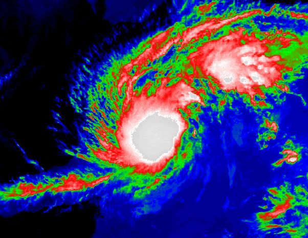
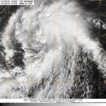
En inmiddels Tropical Storm Sean. Trekt richting Bermuda.
[ afbeelding ]
En het gaat ook nog een categorie 1 worden. Leek eerst bij een tropische storm te blijven.quote:
[..]
Vooralsnog gaat ie precies zoals voorspeld. Eerst heel langzaam beetje westwaards, dan noordwest, noordnoordwest, noordnoordoost, en rap richting noordoost. Toch knap.
De verwachting volgens noaa is 65 kts (120 km/uur) en windstoten tot 80 kts (148 km/uur).
Seizoen in de Atlantische Oceaan is bijna over. Kans wordt steeds kleiner dat er nog wat gaat ontstaan.
Uiteindelijk viel het erg mee 
Doe mee met het voorspellen van het weer!
Weekvoorspelling | Week 45 (invullen tot 3-11 11:59)
Maandvoorspelling November (Gesloten)
Jaarvoorspelling 2024 / 2025
Weekvoorspelling | Week 45 (invullen tot 3-11 11:59)
Maandvoorspelling November (Gesloten)
Jaarvoorspelling 2024 / 2025
Vertaald van Accuweatherquote:Orkaanseizoen ten einde, maar nog één truc uit de doos?
Officieel eindigen zowel het Atlantische als het Oost-Pacifische orkaanseizoen eind november. Maar beide gebieden lijken nog één laatste poging te doen...
Er zijn indicaties dat één tropisch systeem in beide gebieden nog een poging zal wagen om uit te groeien tot tropische storm (of meer)
Voor beide gebieden zou deze ontwikkeling op zijn minst problemen kunnen geven aan scheepvaart routes en elk tropisch systeem aan de westkust van Mexico en Centraal America levert problemen op voor cruiseschepen.
Het ziet er naar uit dat een depressie zal proberen zich te ontwikkelen bij de Kleine Antillen en bij de kust van Centraal America in de Grote Oceaan.
Volgens Orkaanexpert Dan Kottlowski:" We hebben het gevoel dat een systeem ten noordoosten van de Kleine Antillen zich de komende tijd zal ontwikkelen, maar het zal de vraag blijven of het nu nog kan uitgroeien tot volledige orkaan. Begin volgende week zou daar meer duidelijkheid over moeten ontstaan"
"Voor de Pacific kijken we naar een depressie die op dit moment enkele honderden mijlen ten zuiden van Guatemala ligt. Daar zit nog potentie om zich te ontwikkelen"
"Tropische ontwikkelingen in deze gebieden in deze tijd van het jaar is zeldzaam maar niet ongewoon. We zullen afwachten wat er nog uit voort gaat komen, maar het lijkt erop dat het seizoen nog één laatste truc uit de doos gaat halen".
Wel geeft Kottlowski aan dat hij met enige zekerheid kan zeggen dat de ontwikkeling in het Atlantische deel geen grote problemen zal gaan opleveren voor het Caraïbisch gebied of de VS, maar dat het gebied in de Pacific wel voor problemen kan gaan zorgen. Normaal gesproken trekken de meeste Oost-Pacifische stormen westwaarts zonder voor overlast te zorgen, maar er zijn uitzonderingen die ineens noordoostwaards gaan en vervolgens Centraal America of Mexico teisteren. Uitzonderlijke regenval kan dan weer aardverschuivingen en overstromingen veroorzaken in deze gebieden.
Goh.. dacht dat ze dat al wistenquote:NYC erg kwetsbaar voor stormen
New York is bijzonder kwetsbaar voor hevige stormen, zo blijkt uit een lijvig overheidsrapport. Bij toekomstige stormen zoals Irene kan op korte tijd een derde van de straten in de stad blank komen te staan en lopen metrolijnen onder.
In augustus zette New York zich nog schrap voor de doortocht van orkaan Irene, maar die zwakte af tot een storm en bracht weinig schade toe. Toch is er reden voor bezorgdheid, stellen wetenschappers: door de klimaatverandering en de stijgende zeespiegel wordt de stad bijzonder kwetsbaar.
In het lijvige rapport ClimAID onderzoeken wetenschappers van onder meer de Cornell University en Columbia University de gevolgen van de klimaatverandering op de hele staat. Ze waarschuwen voor hetere zomers, meer sneeuw in de winters en regelmatige overstromingen, en voor de gevolgen voor de landbouwers in de staat.
Maar de meest opvallende conclusie is ongetwijfeld de enorme kwetsbaarheid van de stad New York zelf. Al in de nabije toekomst kan de zeespiegel er met meer dan 20 centimeter stijgen, en tegen 2080 met ruim 1 meter.
Binnen het uur
Als dat gebeurt, komt New York ernstig in gevaar, en met name Lower Manhattan, het meest zuidelijke deel en het hart van de stad met onder meer het stadhuis en de site van het World Trade Center. Stormen die nu maar eens om de honderd jaar voorkomen, kunnen door de klimaatverandering vaker voorkomen en door de hogere zeespiegel tot ernstige overstromingen leiden.
"De effecten van een overstromingsscenario zouden erg snel plaatsvinden. Zo zullen veel van de tunnels onder het waterniveau (waaronder metrolijnen, snelwegen en spoorwegen) binnen 1 uur onderlopen", stelt de studie. Ook de luchthavens lopen gevaar. "Rond La Guardia Airport zal de stijgende zeespiegel de huidige dammen ineffectief maken, zelfs bij minder sterke stormen. Transportsystemen zullen daar naar schatting 1 tot 29 dagen buiten werking zijn."
Ongelijk getroffen
Nog volgens het rapport zouden bepaalde bevolkingsgroepen harder getroffen worden dan andere. Minderheden en armere bewoners wonen vaker in gebieden die kwetsbaar zijn voor overstromingen. Senioren en mensen met gezondheidsproblemen zijn dan weer kwetsbaarder voor hittegolven. Senioren, zieken en mensen met een handicap zijn bovendien minder mobiel en kunnen minder snel de noodcentra bereiken bij een storm. (ips/gb)
20% inmiddels...ziet er naar uit dat de Azoren er last van gaan krijgen, mogelijk daarna Engelandquote:
Dit systeem in de oost pacific lijkt zich goed te ontwikkelen. Geen bedreiging voor land en nu nog een tropische depressie, maar gaat waarschijnlijk in kracht toenemen tot een orkaan.
quote:Rare encounter: Tropical Storm Kenneth
A depression south of Mexico has strengthened into Tropical Storm Kenneth, a rare feat for this time of year.
AccuWeather.com Expert Senior Meteorologist Alex Sosnowski recently suggested that the eastern Pacific would have one last hurrah before hurricane season ends with November. That notion came true late Saturday afternoon.
The Atlantic Basin may follow suit in the upcoming days.
Tropical Depression 13-E took shape Saturday afternoon and strengthened into Tropical Storm Kenneth about 24 hours later.
The AccuWeather.com Hurricane Center has the latest statistics on Kenneth.
Not since Hurricane Winnie in 1983 has a tropical storm in the eastern Pacific formed this late in the season. Winnie took shape on Dec. 4 of that year.
It is possible that Kenneth will eventually reach hurricane status as it churns westward through midweek.
No land masses lie in the future path of Kenneth. Only shipping interests will be threatened.
As Kenneth continues to intensify, residents and vacationers along Mexico's southwestern coast may notice an increase in wave action.

Het maximale windveld van Kenneth is momenteel ruim 200 km/uur, waarbij de windstoten uitschieten tot bijna 250 km/uur. De kerndruk is 957mb, waarmee het een categorie 3 orkaan is geworden. De verwachting is dat kenneth nog verder in kracht zal toenemen waardoor het windveld zal toenemen tot boven de 222 km/uur (wat bij een categorie 4 hoort).
Kenneth heeft nu een perfect oog
Kenneth heeft nu een perfect oog
Kenneth zorgt voor een record. Het is de zwaarste orkaan in de oost pacific zo laat in het seizoen.
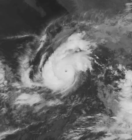
quote:Hurricane Kenneth
Hurricane Kenneth is now the strongest hurricane on record to exist in the eastern Pacific basin so late in the hurricane season.
As of Tuesday morning, November 22, Kenneth is a category 4 hurricane with top sustained winds of 145 mph. Fortunately, Kenneth is nowhere near land and will only be a dangerous hazard to marine interests.
This is a series of visible satellite images captured on Tuesday morning by GOES 15 showing a very distinct and symmetric eye of Hurricane Kenneth.
Click here - http://bit.ly/uC7nph - for a much larger and in-depth look at Hurricane Kenneth. _Image courtesy of http://cimss.ssec.wisc.edu_
More info on Kenneth: http://wxch.nl/vKmXlU

The 'eye' of Kenneth
quote:Monster Kenneth breaks record
Hurricane Kenneth formed in the eastern Pacific Ocean early this week, a rare feat for this time of year. What is even more impressive is how strong it has become.
Kenneth, which gained monster Category 4 status, is the strongest hurricane ever so late in the season for the basin.
AccuWeather.com's Jesse Ferrell reports that no other major (Category 3 or greater) hurricanes have been observed in the eastern Pacific during the month of November since records began in the 1800s.
Ferrell has more images and details in his blog.
AccuWeather.com Expert Senior Meteorologist Alex Sosnowski recently suggested that the eastern Pacific would have one last hurrah before hurricane season ends on November 30. That notion came true late Saturday afternoon.
The Atlantic Basin may follow suit in the upcoming days.
Tropical Depression 13-E took shape Saturday afternoon and strengthened into Tropical Storm Kenneth about 24 hours later. During Monday morning, Kenneth became a hurricane. By Tuesday morning, the storm had exploded into a major Category 4 hurricane.
This image was captured from a high resolution animation of the eye of Hurricane Kenneth from CIMSS.
The AccuWeather.com Hurricane Center has the latest statistics on Kenneth.
Not since Hurricane Winnie in 1983 has a tropical storm in the eastern Pacific formed this late in the season. Winnie took shape on Dec. 4 of that year.
According to Western Weather Expert Ken Clark, "Rain and waves from Kenneth will not reach Southern California."
No land masses lie in the projected westward path of Kenneth. However, shipping lanes will be threatened.
According to Expert Senior Meteorologist Alex Sosnowski, "Freighters will want to steer clear of Kenneth when approaching or heading away from the Panama Canal in the eastern Pacific.
As Kenneth remains a powerful storm, residents and vacationers along Mexico's southwestern coast may notice an increase in wave action.


Dit systeem bij India lijkt zich goed te ontwikkelen. GFS laat deze langs de westkust van India trekken in de richting van Pakistan.
quote:The Atlantic Hurricane season ends
The 2011 Atlantic Hurricane Season will end Wednesday on a quiet note, but not after going down in the record books as one of the most active on record.
On Monday, National Oceanic and Atmospheric Administration (NOAA) officials released a list of final statistics for the season, which included a post-storm upgrade of Tropical Storm Nate to hurricane status and the addition of a previously unclassified, unnamed tropical storm.
In all, 19 named tropical systems prowled the Tropical Atlantic Basin this season, with seven achieving hurricane status and three major hurricane status (Category 3 hurricane or stronger).
With 19 storms, 2011 goes in the record books as tied for the third-highest total since records began in 1851 (joining 1887, 1995 and 2010).
The unnamed tropical system, which formed in early September between Bermuda and Nova Scotia, was added to the list after an analysis of past satellite images by NOAA. The agency points out this storm could have gone undetected in the pre-satellite era.
Concerning the number of hurricanes, 2011 was fairly ordinary.
In a typical year, 11 storms are named, with six becoming hurricanes and two major hurricanes.
However, Hurricane Irene stood above the rest in reminding the east coast of the U.S. that it only takes one hurricane to make a memorable season.
On Aug. 27th, Irene became the first hurricane to make landfall in the U.S. mainland since Ike in 2008.
"Irene broke the 'hurricane amnesia' that can develop when so much time lapses between landfalling storms," said Jack Hayes, Ph.D., director of NOAA's National Weather Service.
Irene was responsible for 56 fatalities and $10.1 billion in damage, with homes, bridges and roads still in the process of being rebuilt from North Carolina to New England more than three months later.
Both AccuWeather.com and NOAA's long-range forecast teams correctly predicted a busier-than-normal season.
Ik kreeg toch niet echt het idee dat dit seizoen zo druk was. Oktober en November waren dan ook zeer rustig, daar zal het wel door komen.quote:
Same idea had ik dus ook... maar goed, als er drie zware orkanen landfall maken en ze spreken over een rustig orkaanseizoen is dat voor ons misschien ook vreemd.quote:
[..]
Ik kreeg toch niet echt het idee dat dit seizoen zo druk was. Oktober en November waren dan ook zeer rustig, daar zal het wel door komen.
Vorig jaar was het ook een rustig seizoen, terwijl ze ook zeiden dat het bovengemiddeld was.


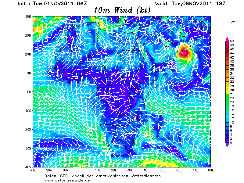
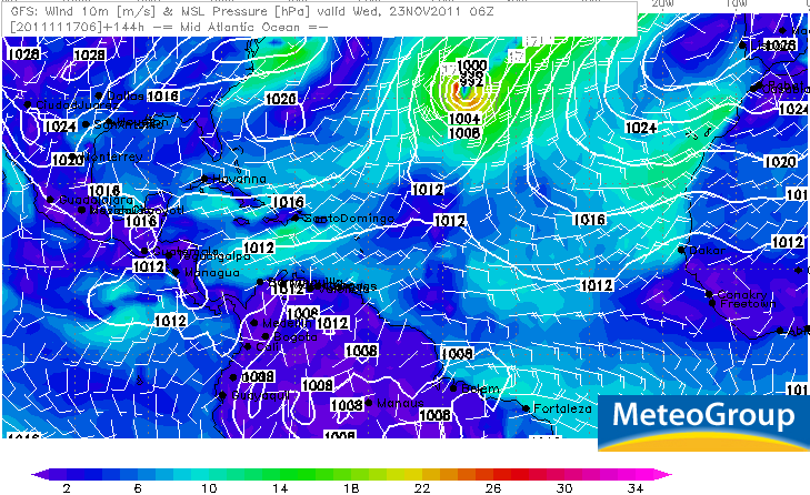
1 model stuur het zelfs naar Siberiequote:Op donderdag 1 december 2011 11:12 schreef Frutsel het volgende:
Zowaar nog een INVEST in de Atlantic....
en die koerst fijn op Europa af
[ afbeelding ]
Lekker met -30


quote:'Cycloon veroorzaakt binnen 4 jaar aardbeving'
Amerikaanse wetenschappers zeggen dat ze bewijs hebben gevonden dat tropische regenstormen worden gevolgd door aardbevingen. Ze suggereren dat de zware regenbuien binnen 4 jaar bevingen veroorzaken.
Onderzoekers van de universiteit van Miami bekeken cyclonen en aardbevingen in Haïti en Taiwan.
'Zware neerslag zorgt voor duizenden aardverschuivingen. De erosie verwijdert grondmateriaal van het oppervlak, wat allerlei bewegingen langs breuklijnen veroorzaakt', zei Shimon Wdowinski, professor of zeegeologie en geofysica donderdag op een congres van de American Geophysical Society in San Francisco.
Voorzichtige prognoses voor 2012:
Bron: PDFquote:We are providing a qualitative discussion of features likely to impact the 2012 Atlantic basin hurricane season rather than a specific numbers forecast. We have suspended issuing quantitative forecasts at this extended-range lead time, since they have not proved skillful over the last 20 years. We attribute the primary reasons for the lack of skill of our early December forecast due to the breakdown of several long-term relationships that worked well in many years of hindcast data, but not in real-time forecasting. We would never have issued a seasonal hurricane forecast that did not show significant skill on many years of hindcast data. In addition, no statistical or dynamical models have shown skill at predicting El Niño – Southern Oscillation (ENSO) at this extended forecast lead time of 9-12 months. This outlook for 2012 will give our assessment of the probability of four potential scenarios for Net Tropical Cyclone (NTC) activity.
We have developed a new way of assessing next year’s activity in terms of two primary physical parameters:
1.
the strength of the Atlantic thermohaline circulation (THC)
2.
the phase of ENSO
We have been in an active era for Atlantic basin tropical cyclones since 1995, and we expect that typical conditions associated with a positive Atlantic Multi-Decadal Oscillation (AMO) and strong thermohaline circulation (THC) to continue. Several forecast models and a qualitative analysis of current conditions in the tropical Pacific indicate that the odds of an El Niño developing this year are somewhat higher than they have been during the past couple of years. In addition, tropical Atlantic sea surface temperatures (SSTs) tend to cool following La Niña events (such as we are currently experiencing), and these will also have to be closely monitored for the upcoming hurricane season. We anticipate that the 2012 Atlantic basin hurricane season will be primarily determined by the strength of the THC/AMO and by the state of ENSO.
We anticipate four possible scenarios with the probability of each as indicated:
1.
THC circulation becomes unusually strong in 2012 and no El Niño event occurs (resulting in a seasonal average net tropical cyclone (NTC) activity of ~ 180) – 15% chance.
2.
THC continues in the above-average condition it has been in since 1995 and no El Niño develops (NTC ~ 140) – 45% chance.
3.
THC continues in above-average condition it has been in since 1995 with the development of a significant El Niño (NTC ~ 75) – 30% chance.
4.
THC becomes weaker and there is the development of a significant El Niño (NTC ~ 40) – 10% chance.
Typically, seasons with the above-listed NTC values have TC activity as follows:
180 NTC – 14-17 named storms, 9-11 hurricanes, 4-5 major hurricanes
140 NTC – 12-15 named storms, 7-9 hurricanes, 3-4 major hurricanes
75 NTC – 8-11 named storms, 3-5 hurricanes, 1-2 major hurricanes
40 NTC – 5-7 named storms, 2-3 hurricanes, 0-1 major hurricanes
quote:Sendong enters Philippine territory, may strengthen
A tropical depression from the east entered Philippine territory Thursday morning and was locally codenamed "Sendong," possibly the last cyclone to enter Philippine territory this year.
The Philippine Atmospheric Geophysical and Astronomical Services Administration said that as of 10 a.m., Sendong was estimated at 840 km east southeast of Hinatuan, Surigao del Sur.
In a post on its Twitter account, PAGASA said Sendong packed maximum winds of 55 kph and is forecast to move west northwest at 30 kph.
"'Sendong' is likely to intensify within the next 24 hours. Estimated rainfall amount is from 10 to 25 mm per hour (moderate to heavy rains) within the 300-km diameter of the tropical depression," it said.
Earlier, PAGASA said it expects only one cyclone to enter or form in Philippine territory this month.
PAGASA said Sendong is not expected to directly affect the country on Thursday, but will make landfall at the Samar-Surigao area between Friday evening and Saturday morning.
Earlier, PAGASA forecaster Sonny Pajarilla said Sendong is expected to stay in Philippine territory during the weekend.
PAGASA's 11 a.m. bulletin said Sendong was expected to be 300 km east southeast of Surigao City Friday morning; and in the vicinity of Iloilo City Saturday morning.
By Sunday morning, it is expected to be 295 km west of Coron, Palawan
twitter:cycloneupdate twitterde op donderdag 15-12-2011 om 14:00:05 IPS forecasting has a potential cyclone forming to the west of Darwin around 21st December and making landfall in WA around 27th December. reageer retweet
 IPS forecasting has a potential cyclone forming to the west of Darwin around 21st December and making landfall in WA around 27th December.
Kan wel eens uitkomen ook... kaartje voor 23 december.quote:twitter:cycloneupdate twitterde op donderdag 15-12-2011 om 14:00:05 IPS forecasting has a potential cyclone forming to the west of Darwin around 21st December and making landfall in WA around 27th December. reageer retweet


quote:Tropical Cyclone Possibility for Australia's Top End
A tropical cyclone could be brewing over warm tropical waters between Australia and Indonesia.
Cyclone formation could take place by Friday over the Arafura or Timor seas off the state of Northern Territory, forecasters at AccuWeather.com believe.
Meteorologists at the Australian Bureau of Meteorology (BoM) have put odds of cyclone formation at "moderate" for Thursday and "high" for Friday.
Depending upon the site its formation and the path taken, a would-be cyclone could pose a threat of high winds and flooding rain to Darwin or points westward along the tropical "Top End" of Australia late in the week.
Offshore waters in the area hold oil and gas production facilities as well as ongoing exploration, whose activities could be disrupted. Vital shipping of minerals from ports along Australia's northwestern shore could also be impacted.
Australia's tropical cyclone season runs from November to April, according to the BoM website. During the cyclone season, there are an average of about 13 such storms in the Australian region, which stretches from the eastern Indian Ocean to the southwestern Pacific Ocean.
Duidelijk weer een draaiing te zien in de Timorzee (noord Australie) en aan de oostkant van Australie.

Darwin on alert as cyclone develops offshore
quote:Darwin residents are bracing for wild weather on Christmas Day as a cyclone heads toward the Top End coast.
The Bureau of Meteorology has upgraded Darwin from a cyclone watch to a cyclone warning.
It is predicting a tropical low off the Top End coast will develop into a category one cyclone around 4:00am ACST, strengthening into a category two system by 10:00pm.
Gusts of up to 110 kilometres per hour are expected to lash the Territory coastline including the Tiwi Islands.
The cyclone is likely to make landfall around Point Stuart, 200 kilometres from Darwin, on Monday.
The bureau's regional director, Andrew Tupper, says Darwin can still expect some wild conditions on Sunday night.
"As the cyclone approaches the coast on Boxing Day, gale force winds would be expected to develop around the coast," he said.
"We are reasonably confident that the cyclone will pass to the east of Darwin."
On alert
NT Chief Minister Paul Henderson is advising people to be where they need to be by 6:00pm on Sunday.
"We don't want people travelling around in potentially gale force winds," he said.
And Police Commissioner John McRoberts says by now Darwin residents should have completed their cyclone preparations.
"There is no longer opportunities to do a great deal of preparation. Those preparations should be complete," he said.
"The most important thing for people to consider in those warning areas is where you will go if you're not confident that your residence is built to cyclone code.
"I urge everybody in the affected warning area to carefully consider which public shelter you will go to or alternative venue should we eventually move to that in the near future. Of course, if you are leaving Darwin, I urge you to make it known to someone that you have left."
The weather bureau will advise when it is time to move to public emergency shelters.
Homeless shelters in Darwin are expected to open at lunchtime tomorrow.
The cyclone warning covers areas from Dundee Beach to Milingimbi, including the Tiwi Islands and Darwin.
Coastal areas from Milingimbi to Nhulunbuy and inland to Jabiru remain on cyclone watch.
Alistair King from The Arnhem Land Progress Association, which runs stores in remote Northern Territory communities, says they have enough supplies to last for weeks if towns are cut off.
"Many of them have been through it before and they know that preparation is the key," he said.
"They're listening to the news, and they're doing as they're told and they're taking it seriously, and I think that's the main thing."

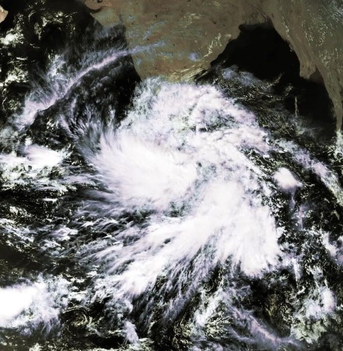
Invest 92b in de Indische Oceaan aan de oostkant van India. Kan ook gevaarlijk worden. GFS stuurt deze richting India en Sri Lanka.
Dit ziet er heftig uit in The Bay of Bengal. Hier zijn al veel doden gevallen door orkanen.
[ Bericht 19% gewijzigd door #ANONIEM op 25-12-2011 22:53:41 ]

[ Bericht 19% gewijzigd door #ANONIEM op 25-12-2011 22:53:41 ]

quote:NT rail line remains cut after floods
It is too early to tell when the rail line between Katherine and Darwin will reopen after a freight train derailment.
The train, operated by Genesee and Wyoming Australia (GWA), derailed at Edith River on Tuesday because of flooding across the track.
It was travelling to Darwin carrying domestic consumables and copper concentrate.
The two train crew were flown to Darwin for hospital treatment with one suffering unspecified injuries.
GWA managing director Bert Easthope said subject to safety checks, the rear portion of the train would be moved back to Katherine to make the freight available for transfer to Darwin.
He said train services that left Adelaide on Tuesday and Wednesday would also terminate at Katherine and the freight made available to customers from Friday.
Mr Easthope said the company was working closely with its customers to minimise the inconvenience of the train derailment.
"We have placed additional resources at Katherine and Alice Springs to help facilitate the movement of freight," he said in a statement on Wednesday.
"We have also sent a number of staff to Darwin to assist with the investigation.
"However, it is still too early to determine the full extent of the incident or how long it will take before the track is reopened," Mr Easthope said.
An initial assessment of the track on Tuesday revealed about 50 metres had been washed away as well as rail across the Edith River bridge.
The derailed train had been slowed down between Alice Springs and Katherine on Christmas Day because of a weather warning associated with cyclone Grant.
But after the cyclone warning was lifted and the rail infrastructure inspected, the service resumed.
"Unexpected and isolated rainfall appears to be a contributing factor to this incident," Mr Easthope said.
http://news.smh.com.au/br(...)-20111228-1pcfh.html

quote:Cycloon Grant doet trein ontsporen
In het noorden van Australië is een vrachttrein ontspoord door de zware regenval van cycloon Grant. De kracht van het water sleurde ook een brug mee.
De goederentrein ontspoorde nabij Katherine, op 317 kilometer ten zuiden van Darwin, de hoofdstad van de Northern Territory. Lokaal parlementslid Willem Westra Van Holthe zei tegen de nationale televisiezender ABC dat stukken asfalt van de Stuart Highway afbraken. Dat is een drieduizend kilometer lange snelweg tussen Darwin en Adelaide.
Politiehoofd David Proctor zei dat automobilisten langs de snelweg gestrand zijn. Hij waarschuwde de bevolking om weg te blijven van het wassende water wegens het gevaar op krokodillen.
Ondertussen is de kracht van cycloon Grant afgenomen tot een tropische storm toen hij de kust op 200 kilometer ten noordoosten van Darwin bereikte. Het meteorologische bureau zei dat het oog van de storm zich op 250 kilometer ten zuidoosten van Darwin bevindt. (belga/sg)
Momenteel een invest tussen madagascar en het vaste land van Afrika. Lijkt erop dat dit systeem over het zuiden van Madagascar gaat trekken en daar een enorme hoeveelheid neerslag gaat achterlaten.

