WKN Weer, Klimaat en Natuurrampen
Lees alles over het onstuimige weer op onze planeet, volg orkanen en tornado's, zie hoe vulkanen uitbarsten en hoe Moeder Aarde beeft bij een aardbeving. Alles over de verwoestende kracht van onze planeet en tal van andere natuurverschijnselen.


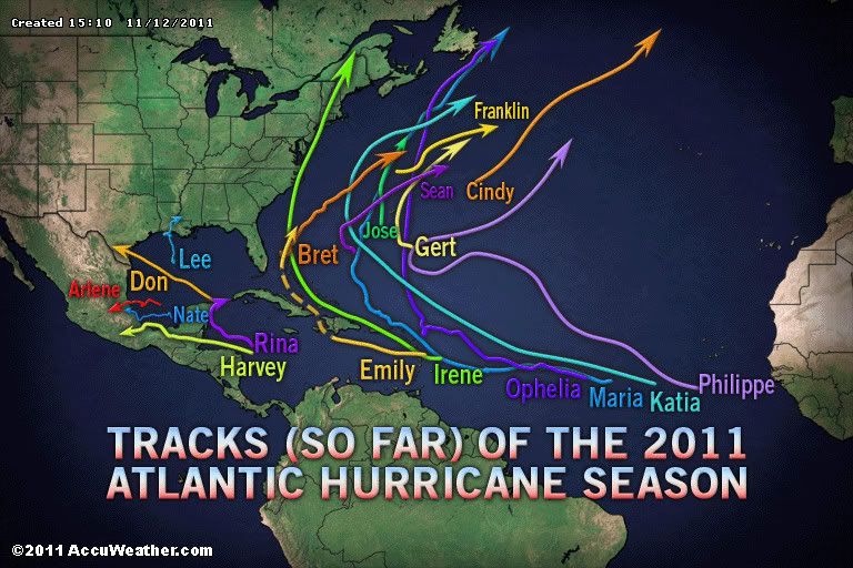
Vooralsnog gaat ie precies zoals voorspeld. Eerst heel langzaam beetje westwaards, dan noordwest, noordnoordwest, noordnoordoost, en rap richting noordoost. Toch knap.quote:Op dinsdag 8 november 2011 09:54 schreef aloa het volgende:
[..]
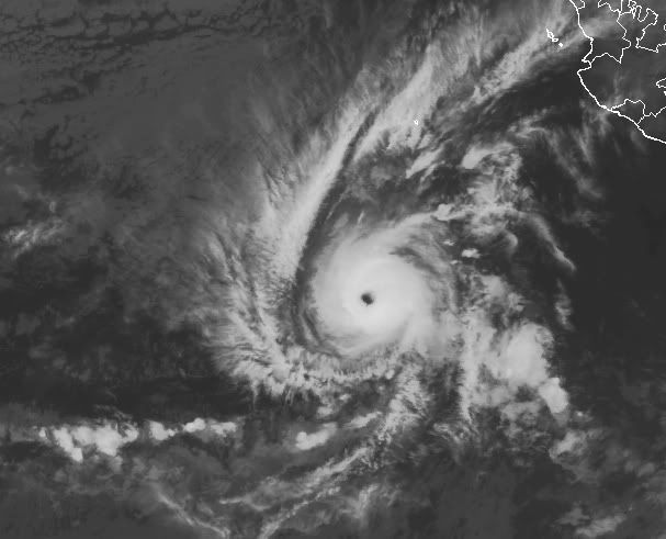
En inmiddels Tropical Storm Sean. Trekt richting Bermuda.
[ afbeelding ]

En het gaat ook nog een categorie 1 worden. Leek eerst bij een tropische storm te blijven.quote:Op donderdag 10 november 2011 13:14 schreef VacaLoca het volgende:
[..]
Vooralsnog gaat ie precies zoals voorspeld. Eerst heel langzaam beetje westwaards, dan noordwest, noordnoordwest, noordnoordoost, en rap richting noordoost. Toch knap.
De verwachting volgens noaa is 65 kts (120 km/uur) en windstoten tot 80 kts (148 km/uur).
Seizoen in de Atlantische Oceaan is bijna over. Kans wordt steeds kleiner dat er nog wat gaat ontstaan.
Uiteindelijk viel het erg mee 
Doe mee met het voorspellen van het weer!
Weekvoorspelling | Week 12 (invullen tot 16-03 - 11:59)
Maandvoorspelling Maart (Inzendingen gesloten)
Jaarvoorspelling 2025 / 2026
Weekvoorspelling | Week 12 (invullen tot 16-03 - 11:59)
Maandvoorspelling Maart (Inzendingen gesloten)
Jaarvoorspelling 2025 / 2026
Vertaald van Accuweatherquote:Orkaanseizoen ten einde, maar nog één truc uit de doos?
Officieel eindigen zowel het Atlantische als het Oost-Pacifische orkaanseizoen eind november. Maar beide gebieden lijken nog één laatste poging te doen...
Er zijn indicaties dat één tropisch systeem in beide gebieden nog een poging zal wagen om uit te groeien tot tropische storm (of meer)
Voor beide gebieden zou deze ontwikkeling op zijn minst problemen kunnen geven aan scheepvaart routes en elk tropisch systeem aan de westkust van Mexico en Centraal America levert problemen op voor cruiseschepen.
Het ziet er naar uit dat een depressie zal proberen zich te ontwikkelen bij de Kleine Antillen en bij de kust van Centraal America in de Grote Oceaan.
Volgens Orkaanexpert Dan Kottlowski:" We hebben het gevoel dat een systeem ten noordoosten van de Kleine Antillen zich de komende tijd zal ontwikkelen, maar het zal de vraag blijven of het nu nog kan uitgroeien tot volledige orkaan. Begin volgende week zou daar meer duidelijkheid over moeten ontstaan"
"Voor de Pacific kijken we naar een depressie die op dit moment enkele honderden mijlen ten zuiden van Guatemala ligt. Daar zit nog potentie om zich te ontwikkelen"
"Tropische ontwikkelingen in deze gebieden in deze tijd van het jaar is zeldzaam maar niet ongewoon. We zullen afwachten wat er nog uit voort gaat komen, maar het lijkt erop dat het seizoen nog één laatste truc uit de doos gaat halen".
Wel geeft Kottlowski aan dat hij met enige zekerheid kan zeggen dat de ontwikkeling in het Atlantische deel geen grote problemen zal gaan opleveren voor het Caraïbisch gebied of de VS, maar dat het gebied in de Pacific wel voor problemen kan gaan zorgen. Normaal gesproken trekken de meeste Oost-Pacifische stormen westwaarts zonder voor overlast te zorgen, maar er zijn uitzonderingen die ineens noordoostwaards gaan en vervolgens Centraal America of Mexico teisteren. Uitzonderlijke regenval kan dan weer aardverschuivingen en overstromingen veroorzaken in deze gebieden.
Goh.. dacht dat ze dat al wistenquote:NYC erg kwetsbaar voor stormen
New York is bijzonder kwetsbaar voor hevige stormen, zo blijkt uit een lijvig overheidsrapport. Bij toekomstige stormen zoals Irene kan op korte tijd een derde van de straten in de stad blank komen te staan en lopen metrolijnen onder.
In augustus zette New York zich nog schrap voor de doortocht van orkaan Irene, maar die zwakte af tot een storm en bracht weinig schade toe. Toch is er reden voor bezorgdheid, stellen wetenschappers: door de klimaatverandering en de stijgende zeespiegel wordt de stad bijzonder kwetsbaar.
In het lijvige rapport ClimAID onderzoeken wetenschappers van onder meer de Cornell University en Columbia University de gevolgen van de klimaatverandering op de hele staat. Ze waarschuwen voor hetere zomers, meer sneeuw in de winters en regelmatige overstromingen, en voor de gevolgen voor de landbouwers in de staat.
Maar de meest opvallende conclusie is ongetwijfeld de enorme kwetsbaarheid van de stad New York zelf. Al in de nabije toekomst kan de zeespiegel er met meer dan 20 centimeter stijgen, en tegen 2080 met ruim 1 meter.
Binnen het uur
Als dat gebeurt, komt New York ernstig in gevaar, en met name Lower Manhattan, het meest zuidelijke deel en het hart van de stad met onder meer het stadhuis en de site van het World Trade Center. Stormen die nu maar eens om de honderd jaar voorkomen, kunnen door de klimaatverandering vaker voorkomen en door de hogere zeespiegel tot ernstige overstromingen leiden.
"De effecten van een overstromingsscenario zouden erg snel plaatsvinden. Zo zullen veel van de tunnels onder het waterniveau (waaronder metrolijnen, snelwegen en spoorwegen) binnen 1 uur onderlopen", stelt de studie. Ook de luchthavens lopen gevaar. "Rond La Guardia Airport zal de stijgende zeespiegel de huidige dammen ineffectief maken, zelfs bij minder sterke stormen. Transportsystemen zullen daar naar schatting 1 tot 29 dagen buiten werking zijn."
Ongelijk getroffen
Nog volgens het rapport zouden bepaalde bevolkingsgroepen harder getroffen worden dan andere. Minderheden en armere bewoners wonen vaker in gebieden die kwetsbaar zijn voor overstromingen. Senioren en mensen met gezondheidsproblemen zijn dan weer kwetsbaarder voor hittegolven. Senioren, zieken en mensen met een handicap zijn bovendien minder mobiel en kunnen minder snel de noodcentra bereiken bij een storm. (ips/gb)
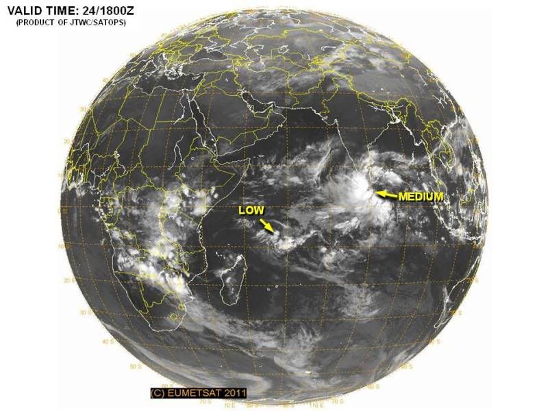
20% inmiddels...ziet er naar uit dat de Azoren er last van gaan krijgen, mogelijk daarna Engelandquote:
Dit systeem in de oost pacific lijkt zich goed te ontwikkelen. Geen bedreiging voor land en nu nog een tropische depressie, maar gaat waarschijnlijk in kracht toenemen tot een orkaan.
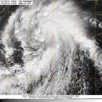
quote:Rare encounter: Tropical Storm Kenneth
A depression south of Mexico has strengthened into Tropical Storm Kenneth, a rare feat for this time of year.
AccuWeather.com Expert Senior Meteorologist Alex Sosnowski recently suggested that the eastern Pacific would have one last hurrah before hurricane season ends with November. That notion came true late Saturday afternoon.
The Atlantic Basin may follow suit in the upcoming days.
Tropical Depression 13-E took shape Saturday afternoon and strengthened into Tropical Storm Kenneth about 24 hours later.
The AccuWeather.com Hurricane Center has the latest statistics on Kenneth.
Not since Hurricane Winnie in 1983 has a tropical storm in the eastern Pacific formed this late in the season. Winnie took shape on Dec. 4 of that year.
It is possible that Kenneth will eventually reach hurricane status as it churns westward through midweek.
No land masses lie in the future path of Kenneth. Only shipping interests will be threatened.
As Kenneth continues to intensify, residents and vacationers along Mexico's southwestern coast may notice an increase in wave action.

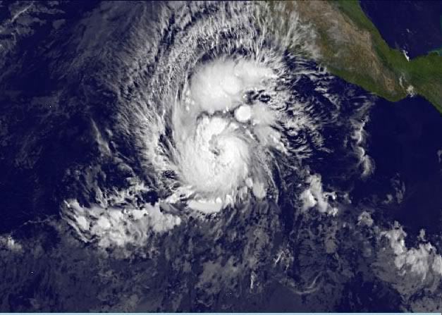
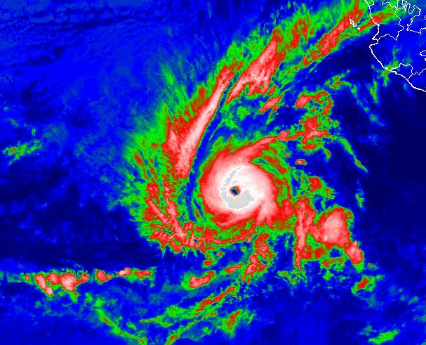
Het maximale windveld van Kenneth is momenteel ruim 200 km/uur, waarbij de windstoten uitschieten tot bijna 250 km/uur. De kerndruk is 957mb, waarmee het een categorie 3 orkaan is geworden. De verwachting is dat kenneth nog verder in kracht zal toenemen waardoor het windveld zal toenemen tot boven de 222 km/uur (wat bij een categorie 4 hoort).
Kenneth heeft nu een perfect oog
Kenneth heeft nu een perfect oog
Kenneth zorgt voor een record. Het is de zwaarste orkaan in de oost pacific zo laat in het seizoen.
quote:Hurricane Kenneth
Hurricane Kenneth is now the strongest hurricane on record to exist in the eastern Pacific basin so late in the hurricane season.
As of Tuesday morning, November 22, Kenneth is a category 4 hurricane with top sustained winds of 145 mph. Fortunately, Kenneth is nowhere near land and will only be a dangerous hazard to marine interests.
This is a series of visible satellite images captured on Tuesday morning by GOES 15 showing a very distinct and symmetric eye of Hurricane Kenneth.
Click here - http://bit.ly/uC7nph - for a much larger and in-depth look at Hurricane Kenneth. _Image courtesy of http://cimss.ssec.wisc.edu_
More info on Kenneth: http://wxch.nl/vKmXlU

The 'eye' of Kenneth
quote:Monster Kenneth breaks record
Hurricane Kenneth formed in the eastern Pacific Ocean early this week, a rare feat for this time of year. What is even more impressive is how strong it has become.
Kenneth, which gained monster Category 4 status, is the strongest hurricane ever so late in the season for the basin.
AccuWeather.com's Jesse Ferrell reports that no other major (Category 3 or greater) hurricanes have been observed in the eastern Pacific during the month of November since records began in the 1800s.
Ferrell has more images and details in his blog.
AccuWeather.com Expert Senior Meteorologist Alex Sosnowski recently suggested that the eastern Pacific would have one last hurrah before hurricane season ends on November 30. That notion came true late Saturday afternoon.
The Atlantic Basin may follow suit in the upcoming days.
Tropical Depression 13-E took shape Saturday afternoon and strengthened into Tropical Storm Kenneth about 24 hours later. During Monday morning, Kenneth became a hurricane. By Tuesday morning, the storm had exploded into a major Category 4 hurricane.
This image was captured from a high resolution animation of the eye of Hurricane Kenneth from CIMSS.
The AccuWeather.com Hurricane Center has the latest statistics on Kenneth.
Not since Hurricane Winnie in 1983 has a tropical storm in the eastern Pacific formed this late in the season. Winnie took shape on Dec. 4 of that year.
According to Western Weather Expert Ken Clark, "Rain and waves from Kenneth will not reach Southern California."
No land masses lie in the projected westward path of Kenneth. However, shipping lanes will be threatened.
According to Expert Senior Meteorologist Alex Sosnowski, "Freighters will want to steer clear of Kenneth when approaching or heading away from the Panama Canal in the eastern Pacific.
As Kenneth remains a powerful storm, residents and vacationers along Mexico's southwestern coast may notice an increase in wave action.


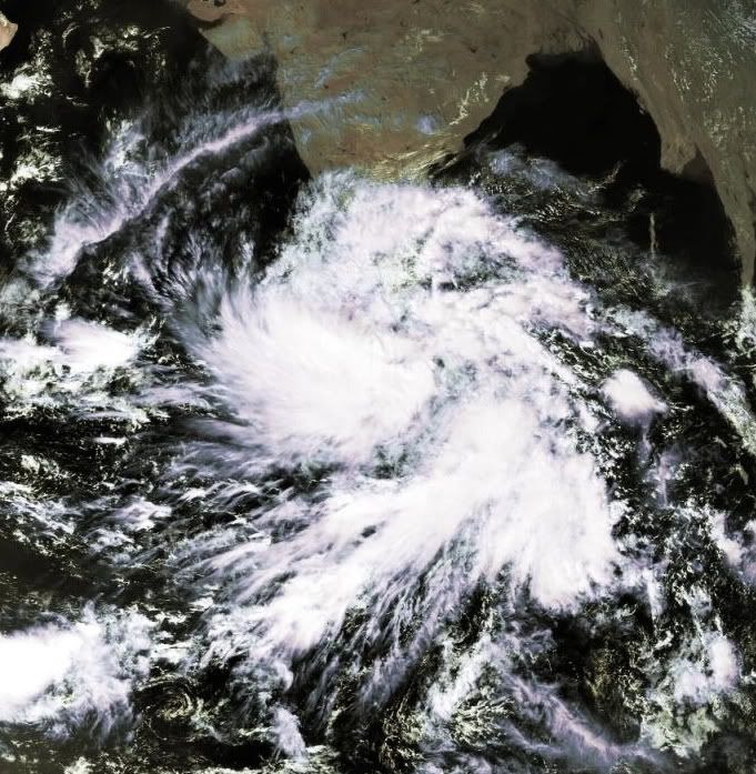
Dit systeem bij India lijkt zich goed te ontwikkelen. GFS laat deze langs de westkust van India trekken in de richting van Pakistan.
quote:The Atlantic Hurricane season ends
The 2011 Atlantic Hurricane Season will end Wednesday on a quiet note, but not after going down in the record books as one of the most active on record.
On Monday, National Oceanic and Atmospheric Administration (NOAA) officials released a list of final statistics for the season, which included a post-storm upgrade of Tropical Storm Nate to hurricane status and the addition of a previously unclassified, unnamed tropical storm.
In all, 19 named tropical systems prowled the Tropical Atlantic Basin this season, with seven achieving hurricane status and three major hurricane status (Category 3 hurricane or stronger).
With 19 storms, 2011 goes in the record books as tied for the third-highest total since records began in 1851 (joining 1887, 1995 and 2010).
The unnamed tropical system, which formed in early September between Bermuda and Nova Scotia, was added to the list after an analysis of past satellite images by NOAA. The agency points out this storm could have gone undetected in the pre-satellite era.
Concerning the number of hurricanes, 2011 was fairly ordinary.
In a typical year, 11 storms are named, with six becoming hurricanes and two major hurricanes.
However, Hurricane Irene stood above the rest in reminding the east coast of the U.S. that it only takes one hurricane to make a memorable season.
On Aug. 27th, Irene became the first hurricane to make landfall in the U.S. mainland since Ike in 2008.
"Irene broke the 'hurricane amnesia' that can develop when so much time lapses between landfalling storms," said Jack Hayes, Ph.D., director of NOAA's National Weather Service.
Irene was responsible for 56 fatalities and $10.1 billion in damage, with homes, bridges and roads still in the process of being rebuilt from North Carolina to New England more than three months later.
Both AccuWeather.com and NOAA's long-range forecast teams correctly predicted a busier-than-normal season.
Ik kreeg toch niet echt het idee dat dit seizoen zo druk was. Oktober en November waren dan ook zeer rustig, daar zal het wel door komen.quote:
Same idea had ik dus ook... maar goed, als er drie zware orkanen landfall maken en ze spreken over een rustig orkaanseizoen is dat voor ons misschien ook vreemd.quote:
[..]
Ik kreeg toch niet echt het idee dat dit seizoen zo druk was. Oktober en November waren dan ook zeer rustig, daar zal het wel door komen.
Vorig jaar was het ook een rustig seizoen, terwijl ze ook zeiden dat het bovengemiddeld was.


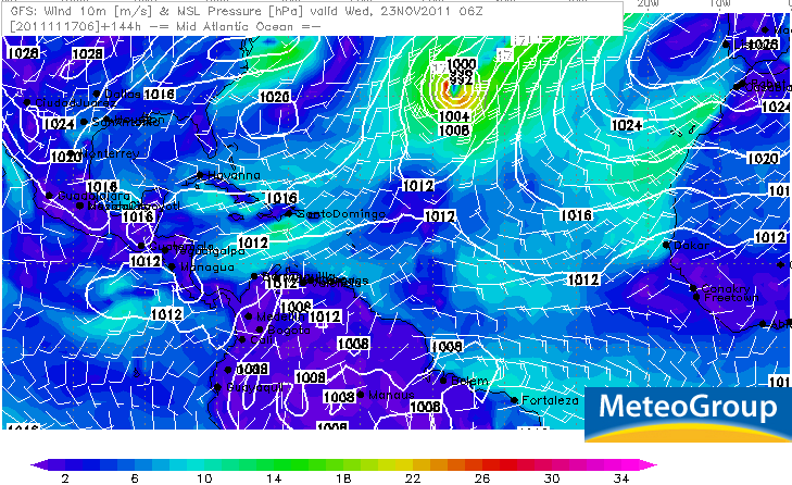
1 model stuur het zelfs naar Siberiequote:Op donderdag 1 december 2011 11:12 schreef Frutsel het volgende:
Zowaar nog een INVEST in de Atlantic....
en die koerst fijn op Europa af
[ afbeelding ]
Lekker met -30


quote:'Cycloon veroorzaakt binnen 4 jaar aardbeving'
Amerikaanse wetenschappers zeggen dat ze bewijs hebben gevonden dat tropische regenstormen worden gevolgd door aardbevingen. Ze suggereren dat de zware regenbuien binnen 4 jaar bevingen veroorzaken.
Onderzoekers van de universiteit van Miami bekeken cyclonen en aardbevingen in Haïti en Taiwan.
'Zware neerslag zorgt voor duizenden aardverschuivingen. De erosie verwijdert grondmateriaal van het oppervlak, wat allerlei bewegingen langs breuklijnen veroorzaakt', zei Shimon Wdowinski, professor of zeegeologie en geofysica donderdag op een congres van de American Geophysical Society in San Francisco.
Voorzichtige prognoses voor 2012:
Bron: PDFquote:We are providing a qualitative discussion of features likely to impact the 2012 Atlantic basin hurricane season rather than a specific numbers forecast. We have suspended issuing quantitative forecasts at this extended-range lead time, since they have not proved skillful over the last 20 years. We attribute the primary reasons for the lack of skill of our early December forecast due to the breakdown of several long-term relationships that worked well in many years of hindcast data, but not in real-time forecasting. We would never have issued a seasonal hurricane forecast that did not show significant skill on many years of hindcast data. In addition, no statistical or dynamical models have shown skill at predicting El Niño – Southern Oscillation (ENSO) at this extended forecast lead time of 9-12 months. This outlook for 2012 will give our assessment of the probability of four potential scenarios for Net Tropical Cyclone (NTC) activity.
We have developed a new way of assessing next year’s activity in terms of two primary physical parameters:
1.
the strength of the Atlantic thermohaline circulation (THC)
2.
the phase of ENSO
We have been in an active era for Atlantic basin tropical cyclones since 1995, and we expect that typical conditions associated with a positive Atlantic Multi-Decadal Oscillation (AMO) and strong thermohaline circulation (THC) to continue. Several forecast models and a qualitative analysis of current conditions in the tropical Pacific indicate that the odds of an El Niño developing this year are somewhat higher than they have been during the past couple of years. In addition, tropical Atlantic sea surface temperatures (SSTs) tend to cool following La Niña events (such as we are currently experiencing), and these will also have to be closely monitored for the upcoming hurricane season. We anticipate that the 2012 Atlantic basin hurricane season will be primarily determined by the strength of the THC/AMO and by the state of ENSO.
We anticipate four possible scenarios with the probability of each as indicated:
1.
THC circulation becomes unusually strong in 2012 and no El Niño event occurs (resulting in a seasonal average net tropical cyclone (NTC) activity of ~ 180) – 15% chance.
2.
THC continues in the above-average condition it has been in since 1995 and no El Niño develops (NTC ~ 140) – 45% chance.
3.
THC continues in above-average condition it has been in since 1995 with the development of a significant El Niño (NTC ~ 75) – 30% chance.
4.
THC becomes weaker and there is the development of a significant El Niño (NTC ~ 40) – 10% chance.
Typically, seasons with the above-listed NTC values have TC activity as follows:
180 NTC – 14-17 named storms, 9-11 hurricanes, 4-5 major hurricanes
140 NTC – 12-15 named storms, 7-9 hurricanes, 3-4 major hurricanes
75 NTC – 8-11 named storms, 3-5 hurricanes, 1-2 major hurricanes
40 NTC – 5-7 named storms, 2-3 hurricanes, 0-1 major hurricanes
quote:Sendong enters Philippine territory, may strengthen
A tropical depression from the east entered Philippine territory Thursday morning and was locally codenamed "Sendong," possibly the last cyclone to enter Philippine territory this year.
The Philippine Atmospheric Geophysical and Astronomical Services Administration said that as of 10 a.m., Sendong was estimated at 840 km east southeast of Hinatuan, Surigao del Sur.
In a post on its Twitter account, PAGASA said Sendong packed maximum winds of 55 kph and is forecast to move west northwest at 30 kph.
"'Sendong' is likely to intensify within the next 24 hours. Estimated rainfall amount is from 10 to 25 mm per hour (moderate to heavy rains) within the 300-km diameter of the tropical depression," it said.
Earlier, PAGASA said it expects only one cyclone to enter or form in Philippine territory this month.
PAGASA said Sendong is not expected to directly affect the country on Thursday, but will make landfall at the Samar-Surigao area between Friday evening and Saturday morning.
Earlier, PAGASA forecaster Sonny Pajarilla said Sendong is expected to stay in Philippine territory during the weekend.
PAGASA's 11 a.m. bulletin said Sendong was expected to be 300 km east southeast of Surigao City Friday morning; and in the vicinity of Iloilo City Saturday morning.
By Sunday morning, it is expected to be 295 km west of Coron, Palawan
twitter:cycloneupdate twitterde op donderdag 15-12-2011 om 14:00:05 IPS forecasting has a potential cyclone forming to the west of Darwin around 21st December and making landfall in WA around 27th December. reageer retweet
 IPS forecasting has a potential cyclone forming to the west of Darwin around 21st December and making landfall in WA around 27th December.
Kan wel eens uitkomen ook... kaartje voor 23 december.quote:twitter:cycloneupdate twitterde op donderdag 15-12-2011 om 14:00:05 IPS forecasting has a potential cyclone forming to the west of Darwin around 21st December and making landfall in WA around 27th December. reageer retweet


quote:Tropical Cyclone Possibility for Australia's Top End
A tropical cyclone could be brewing over warm tropical waters between Australia and Indonesia.
Cyclone formation could take place by Friday over the Arafura or Timor seas off the state of Northern Territory, forecasters at AccuWeather.com believe.
Meteorologists at the Australian Bureau of Meteorology (BoM) have put odds of cyclone formation at "moderate" for Thursday and "high" for Friday.
Depending upon the site its formation and the path taken, a would-be cyclone could pose a threat of high winds and flooding rain to Darwin or points westward along the tropical "Top End" of Australia late in the week.
Offshore waters in the area hold oil and gas production facilities as well as ongoing exploration, whose activities could be disrupted. Vital shipping of minerals from ports along Australia's northwestern shore could also be impacted.
Australia's tropical cyclone season runs from November to April, according to the BoM website. During the cyclone season, there are an average of about 13 such storms in the Australian region, which stretches from the eastern Indian Ocean to the southwestern Pacific Ocean.
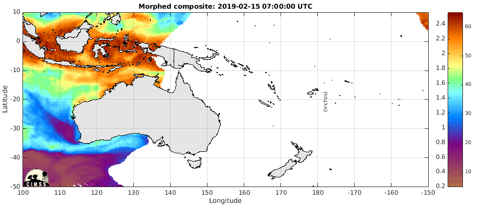
Duidelijk weer een draaiing te zien in de Timorzee (noord Australie) en aan de oostkant van Australie.

Darwin on alert as cyclone develops offshore
quote:Darwin residents are bracing for wild weather on Christmas Day as a cyclone heads toward the Top End coast.
The Bureau of Meteorology has upgraded Darwin from a cyclone watch to a cyclone warning.
It is predicting a tropical low off the Top End coast will develop into a category one cyclone around 4:00am ACST, strengthening into a category two system by 10:00pm.
Gusts of up to 110 kilometres per hour are expected to lash the Territory coastline including the Tiwi Islands.
The cyclone is likely to make landfall around Point Stuart, 200 kilometres from Darwin, on Monday.
The bureau's regional director, Andrew Tupper, says Darwin can still expect some wild conditions on Sunday night.
"As the cyclone approaches the coast on Boxing Day, gale force winds would be expected to develop around the coast," he said.
"We are reasonably confident that the cyclone will pass to the east of Darwin."
On alert
NT Chief Minister Paul Henderson is advising people to be where they need to be by 6:00pm on Sunday.
"We don't want people travelling around in potentially gale force winds," he said.
And Police Commissioner John McRoberts says by now Darwin residents should have completed their cyclone preparations.
"There is no longer opportunities to do a great deal of preparation. Those preparations should be complete," he said.
"The most important thing for people to consider in those warning areas is where you will go if you're not confident that your residence is built to cyclone code.
"I urge everybody in the affected warning area to carefully consider which public shelter you will go to or alternative venue should we eventually move to that in the near future. Of course, if you are leaving Darwin, I urge you to make it known to someone that you have left."
The weather bureau will advise when it is time to move to public emergency shelters.
Homeless shelters in Darwin are expected to open at lunchtime tomorrow.
The cyclone warning covers areas from Dundee Beach to Milingimbi, including the Tiwi Islands and Darwin.
Coastal areas from Milingimbi to Nhulunbuy and inland to Jabiru remain on cyclone watch.
Alistair King from The Arnhem Land Progress Association, which runs stores in remote Northern Territory communities, says they have enough supplies to last for weeks if towns are cut off.
"Many of them have been through it before and they know that preparation is the key," he said.
"They're listening to the news, and they're doing as they're told and they're taking it seriously, and I think that's the main thing."
