WKN Weer, Klimaat en Natuurrampen
Lees alles over het onstuimige weer op onze planeet, volg orkanen en tornado's, zie hoe vulkanen uitbarsten en hoe Moeder Aarde beeft bij een aardbeving. Alles over de verwoestende kracht van onze planeet en tal van andere natuurverschijnselen.


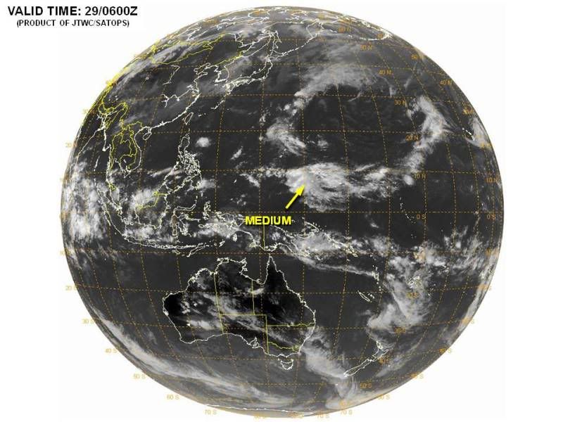
70%
quote:. THUNDERSTORM ACTIVITY HAS INCREASED AND BECOME CONCENTRATED DURING
THE PAST SEVERAL HOURS NEAR THE CENTER OF A LOW PRESSURE AREA IN
THE SOUTHWESTERN CARIBBEAN SEA...LOCATED ABOUT 150 MILES MILES
EAST-SOUTHEAST OF THE NICARAGUAN/HONDURAN BORDER. ENVIRONMENTAL
CONDITIONS ARE GRADUALLY BECOMING MORE CONDUCIVE FOR DEVELOPMENT...
AND A TROPICAL DEPRESSION COULD FORM LATER TODAY OR TONIGHT. THIS
SYSTEM HAS A HIGH CHANCE...70 PERCENT...OF BECOMING A TROPICAL
CYCLONE DURING THE NEXT 48 HOURS AS IT MOVES SLOWLY NORTHWARD AND
THEN NORTHWESTWARD. REGARDLESS OF DEVELOPMENT...LOCALLY HEAVY RAINS
AND GUSTY WINDS SHOULD CONTINUE TO AFFECT PORTIONS OF HONDURAS AND
NICARAGUA THROUGH MONDAY. AN AIR FORCE RESERVE HURRICANE HUNTER
AIRCRAFT IS SCHEDULED TO INVESTIGATE THIS DISTURBANCE THIS
AFTERNOON...IF NECESSARY.


quote:TS RINA FACES SERIOUS OBSTACLES- IF IT OVERCOMES THEM, IT COULD BE A REAL PROBLEM
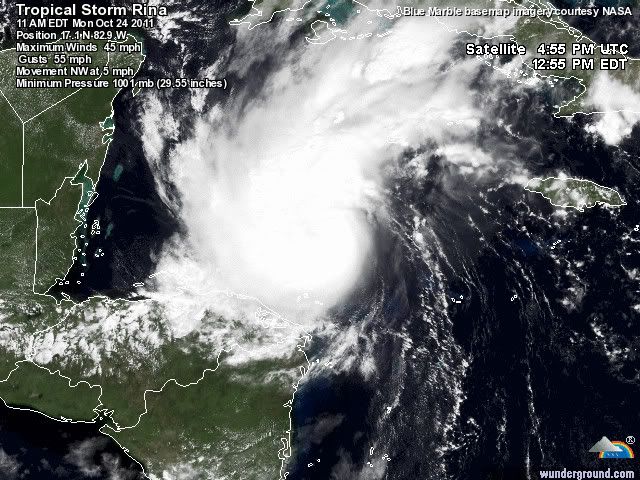
It was exactly six years ago today that we were in the midst of dealing with a powerful hurricane Wilma as it tore through south Florida. At one point, Wilma was the most intense Atlantic hurricane ever recorded. It went on to deal a significant punch to portions of the Yucatan peninsula before moving northeast and in to south Florida where it knocked out power for at least 6 million people, some until near Thanksgiving of that year. My point is- this time of year is climatologically favorable for strong Caribbean hurricanes that can reach land, including Florida. Now, six years later, we have tropical storm Rina in a similar position as Wilma was, tucked in to the northwest Caribbean Sea. Will the final outcome be just as similar or vastly different? Let's take a look at what we know.
First off, the NHC is forecasting Rina to become a hurricane as it approaches the northeast Yucatan later this week. Water temperatures in the region are very warm as is the heat content value. In other words, the water is not only warm at the surface, but also quite deep below the surface so that as the ocean is churned up, more warm water comes to the surface, not cooler water. This provides an incredible amount of heat energy for torpical cyclones and Rina could take advantage of this. On the other hand, there is an obvious lack of vertical instability across the region due to dry air in the atmoshphere. Tropical cyclones need very unstable and moist air to generate the powerful upward motion that leads to convection or thunderstorm activity. I would say that dry air is perhaps a more prolific killer of hurricanes than any other factor. Cold water is a slow process as it has to slowly eat away at away at the energy source. Dry air, especially that is entrained within the circulation itself, can literally deflate a tropical cyclone in a matter of hours, sometimes less. Think back to Irene. It was forecast by some to become an intense hurricane off the North Carolina coast. Instead, dry mid-level air became pulled in to the circulation and down the convection went. Irene never recovered. The NHC mentions this dry air in their latest discussion and if Rina gets involved with that, it will almost certainly mean it cannot strengthen much at all.
On the other hand, if Rina is able to fight off the dry air and create its own moist environment, taking advantage of the very warm water across the region, it could intensify fairly substantially. For what ever reason, this is what the GFDL and HWRF models indicate as both predict a very strong hurricane to materialize. Conversely, the SHIPS intensity model, which is not as robust or dynamic as the GFDL and HWRF models, only shows modest strengthening but not even to hurricane status. Regardless, the NHC's official forecast shows 75 mph in about four days. It is possible that Rina never makes it to that intensity but I caution you too that it is also possible for Rina to be considerably stronger. Remember that intensity forecasts are notoriously prone to errors. This is why it is important to always be ready when a tropical cyclone is heading your way. There was not one model that predicted Ophelia would become a category four hurricane way out in the open Atlantic at 33.8 degrees north latitude. Intensity forecasts were off by as much as 60 knots for Ophelia and it was over only barely warm enough water to even sustain itself. Odds are that Rina will succomb to the hostile October (and seasonal) environment that lies before it. This is not 2005 when everything was perfect from June through January of 2006. So far, the season has produced an overwhelming amount of stable air across much of the tropics. While this could change with Rina, there is little reason to doubt that it will right now.
As far as the track is concerned, a lot depends on intensity. Again, the GFDL and HWRF models show a strong, well developed hurricane coming out of the Caribbean and tracking in to south Florida. The NHC is not buying this scenario right now due to the limiting factors I mentioned above. The global models, specifically the GFS and ECMWF show no impact to Florida. However, interests along the eastern coast of the Yucatan need to follow Rina's progress closely. It is too soon to know with much certainty whether or not the storm will have a direct impact on the region but the current forecast indicates a possible landfall along the northeast coast in about five days. Obviously this can change, and probably will but for now, Rina is a possible threat to land. We'll know more as each day passes and we see how the steering and intensity situation plays out. I wll be very interested to see if the hurricane specific models, the GFDL and HWRF, are correct or if they have lost touch with reality and come no where near being accurate with this situation. It will be an interesting week ahead to be sure.
 Op
Op 
Het is de vraag wat Rina gaat doen. Echt duidelijk is dat nog niet. De modellen weten het ook niet helemaal. GFS laat het systeem nu voor een lange tijd rondtollen in de Caribische Zee.
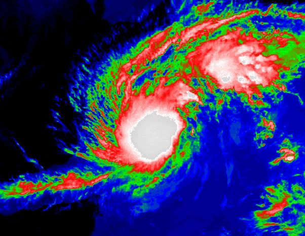
Rina is een tropische storm met een windsnelheid van 72 km/uur. Dit is te vergelijken met een windkracht 8 en bijna een stormkracht 9. De windstoten halen 88 km/uur. De verwachting is dat Rina langzaam in kracht zal toenemen en een categorie 1 zal worden.
Rina is een tropische storm met een windsnelheid van 72 km/uur. Dit is te vergelijken met een windkracht 8 en bijna een stormkracht 9. De windstoten halen 88 km/uur. De verwachting is dat Rina langzaam in kracht zal toenemen en een categorie 1 zal worden.
Rina:


quote:REPORTS FROM AN AIR FORCE RESERVE HURRICANE HUNTER AIRCRAFT INDICATE
THAT THE MAXIMUM SUSTAINED WINDS HAVE INCREASED TO NEAR 75 MPH...
120 KM/H...WITH HIGHER GUSTS. RINA IS A CATEGORY ONE HURRICANE ON
THE SAFFIR-SIMPSON HURRICANE WIND SCALE. ADDITIONAL STRENGTHENING
IS EXPECTED DURING THE NEXT 48 HOURS AND RINA IS FORECAST TO BECOME
A MAJOR HURRICANE BY LATE TUESDAY.
SATELLITE IMAGES AND REPORTS FROM AN AIR FORCE RESERVE HURRICANE
HUNTER AIRCRAFT INDICATE THAT RINA HAS RAPIDLY STRENGTHENED. THE
AIRCRAFT REPORTED PEAK 850 MB FLIGHT-LEVEL WINDS OF 68 KT AND
BELIEVABLE SFMR WINDS AROUND 65 KT. BASED ON THESE DATA THE
INITIAL INTENSITY IS INCREASED TO 65 KT...MAKING RINA THE 6TH
HURRICANE OF SEASON IN THE ATLANTIC BASIN. THIS SPECIAL ADVISORY
HAS BEEN ISSUED TO INCREASE THE INITIAL AND FORECAST INTENSITIES
FROM THE PREVIOUS FORECAST...BUT NO CHANGE TO THE TRACK WAS
REQUIRED.
Doe mee met het voorspellen van het weer!
Weekvoorspelling | Week 12 (invullen tot 16-03 - 11:59)
Maandvoorspelling Maart (Inzendingen gesloten)
Jaarvoorspelling 2025 / 2026
Weekvoorspelling | Week 12 (invullen tot 16-03 - 11:59)
Maandvoorspelling Maart (Inzendingen gesloten)
Jaarvoorspelling 2025 / 2026
Ja wie had dat even gedacht!quote:Op maandag 24 oktober 2011 21:37 schreef aloa het volgende:
[..]
Gaat nog een major hurricane worden ook.
Die Rina zal ons nu wel uitlachen
Doe mee met het voorspellen van het weer!
Weekvoorspelling | Week 12 (invullen tot 16-03 - 11:59)
Maandvoorspelling Maart (Inzendingen gesloten)
Jaarvoorspelling 2025 / 2026
Weekvoorspelling | Week 12 (invullen tot 16-03 - 11:59)
Maandvoorspelling Maart (Inzendingen gesloten)
Jaarvoorspelling 2025 / 2026
Lol pas maar op, Televaag heeft het over een "megaslechtweergebied"
http://www.telegraaf.nl/b(...)Cancn__.html?cid=rss
http://www.telegraaf.nl/b(...)Cancn__.html?cid=rss
Weer of geen weer, altijd actueel www.onweer-online.nl
Zal vanmiddag of vanavond nog wel naar 3 gaanquote:
Ben benieuwd of ze stand houdt na de landfall en dan afwachten wat er in de Golf nog van over is.
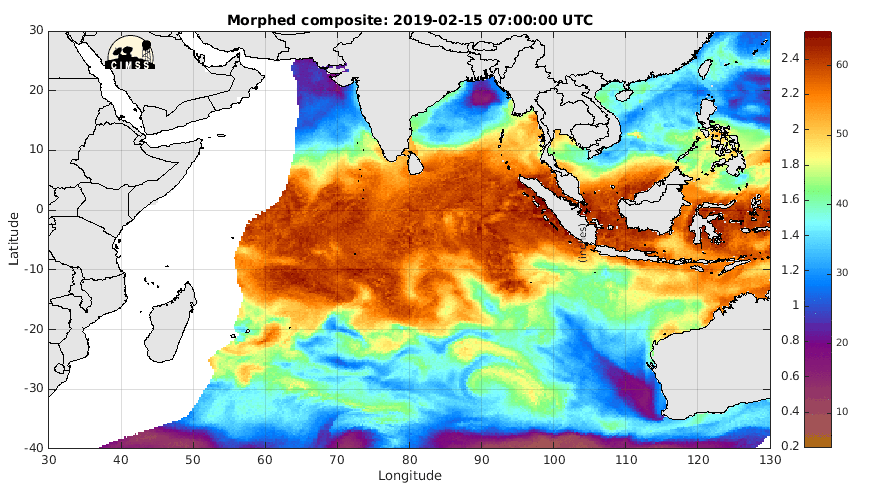
Voor de kust van Oman en Yemen. Ze gaan daar flink wat neerslag krijgen. Over een paar dagen lijkt zich nog een gebied te ontwikkelen aan de westkant van India.
Ben benieuwd, laatste jaren komt daar toch zeker wel een flinke orkaan vandaan.
Nu het Atlantische seizoen voorbij is zal daar de kern van activiteit wel liggen, net als bij Bangladesh enzo
Nu het Atlantische seizoen voorbij is zal daar de kern van activiteit wel liggen, net als bij Bangladesh enzo
Gemiddeld komt er 1 orkaan per jaar voor in de Arabische zee. In het gebied bij India en Bangladesch komen ze iets (maar ook niet veel) vaker voor.quote:Op dinsdag 1 november 2011 13:24 schreef Frutsel het volgende:
Ben benieuwd, laatste jaren komt daar toch zeker wel een flinke orkaan vandaan.
Nu het Atlantische seizoen voorbij is zal daar de kern van activiteit wel liggen, net als bij Bangladesh enzo
Ben benieuwd of dit doorzet.
Nargis (2008) was een april of mei storm dacht ik.. weet niet hoe erg november kan zijn daar. Maar het is wel de actiefste maand samen met mei
Tropical Cyclone Season Begins for Australia
The Australian tropical cyclone season has begun as of the first of November, and it will last through the end of April 2012.
Based upon the historical record, the season normally produces 12 tropical cyclones in the Australian region, according to the Australian Bureau of Meteorology (BoM). A plurality of storms live out their life cycle off northwestern Australian, sometimes making landfall on the rather sparsely settled coast.
Forecasters for the BoM have forecast an above-normal number of tropical cyclones for the 2011-12 season, with an 80 percent likelihood of occurrence. The neutral to borderline La Nina state of the tropical Pacific Ocean, during the Northern Hemisphere summer, was cited as favoring the above-normal storm count.
The sea-surface cooling that marks "La Nina" conditions in the tropical Pacific Ocean tends to boost tropical cyclone incidence in the Australian region.
Last season, there were 11 named tropical cyclones in the Australian region, of which five were rated a "Severe Tropical Cyclone."
The strongest storm was Severe Tropical Cyclone Yasi which, at its height, wielded a 130-mph fury. Yasi's landfall in northeastern Queensland led to one of the most costly storm aftermaths in Australia's history.
Accuweather
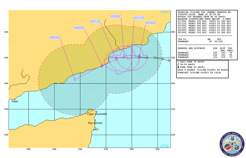
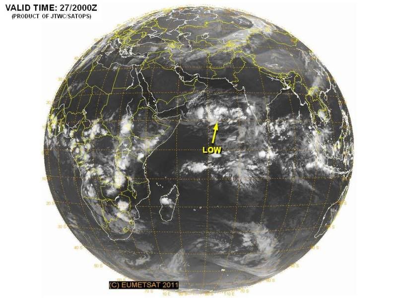
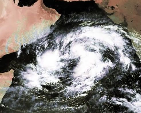
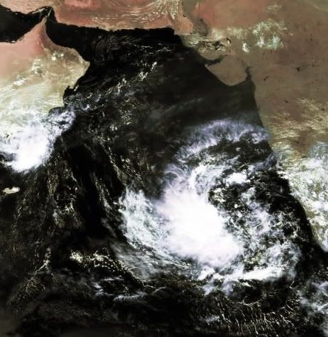
quote:Cyclone Keila soaking Arabia
Tropical Cyclone Keila, an unusual visitor to Arabia, will unleash drenching rain as it hovers near the south coast of Arabia for the next day or so.
Flash flooding will be the greatest storm threat to life and property, as Keila's moderate intensity will preclude widespread high winds over land.
In southwestern Oman, Keila has already triggered rainfall of 50 to 100 mm (2 to 4 inches) in the area of Salalah and the port of Raysut. This amount is comparable to a normal year's rainfall. What is more, as much more rain could pelt the area before the storm dissipates along the coast near the Oman-Yemen border.
Tropical cyclones are rare events along the coast of Oman and Yemen. When they have made landfall, they have historically triggered flash flashing, as happened with severe, destructive Tropical Cyclone Gonu in June 2007.
Another cyclonic storm struck Yemen from the Gulf of Aden in October 2008, resulting in severe flooding.
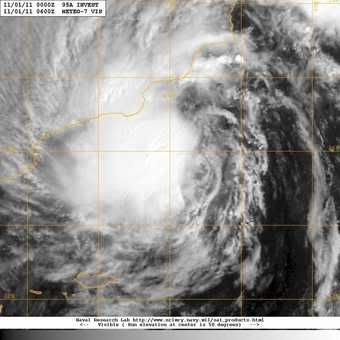
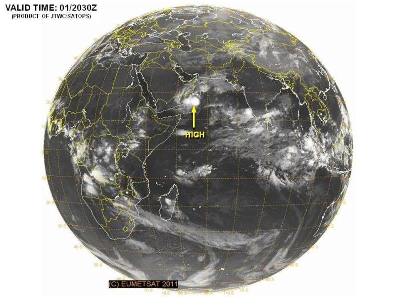
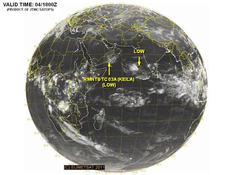
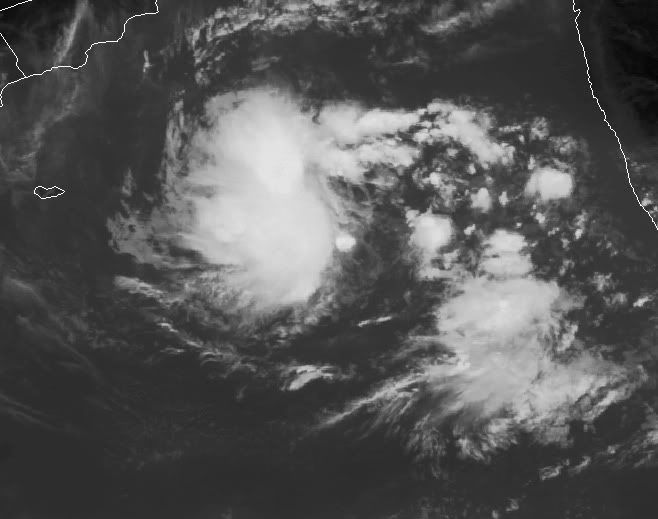
Nieuwe invest in de Arabische zee. Bij Jemen is nog het restant van Keila te zien.
Keila heeft voor 14 doden en 200 gewonden gezorgd in Oman. Er is een enorme hoeveelheid regen gevallen waardoor in sommige gebieden het water bijna 2 meter hoog staat.
Keila heeft voor 14 doden en 200 gewonden gezorgd in Oman. Er is een enorme hoeveelheid regen gevallen waardoor in sommige gebieden het water bijna 2 meter hoog staat.
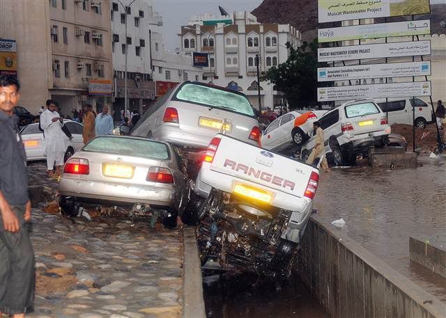
quote:MUSCAT, Oman — The death toll from a tropical storm that swept across Oman has risen to 14 with several bodies turning up in surging floodwaters, officials said on Thursday.
At least 200 people were injured in the cloudburst that lashed the largely desert sultanate on the eastern flanks of the Arabian Peninsula, a location that puts it in the path of seasonal monsoons or cyclones.
"The latest update is that five people who were missing were confirmed dead, bringing the number up to 14," a rescue services spokesman said.
The storm began on Tuesday, flooded many areas and is expected to linger over much of the country until Saturday.
Authorities had to airlift 60 patients out of two hospitals, which temporarily closed because of flood damage. "My estimate is that it will cost no less than 20 million rials ($50 million) to put (the hospitals) right," a doctor said.
"In some parts of the country, the water level was six feet (about 1.80 metres) high," the spokesman said.
Witnesses said cars were swept away as rainwater swamped major motorways. Some drivers scrambled to the rooftops of their cars to escape rising flash floods.
"One valley had everything floating in it, including cars, dead animals and people's personal belongings," eyewitness Saud Al Ghaith told Reuters from his home town of Rostaq, north of the capital Muscat.
Oman was hit last year by Cyclone Phet, which killed about 50 people in different parts of the sultanate.
Voetballende broertjes komen om bij zwaar onweer in Oman
In totaal veertien doden door tropische storm Keila
Storm en hevige regen in het sultanaat Oman hebben aan veertien mensen het leven gekost. Enkelen onder hen verdronken in overstroomde wadi's bij de passage van de tropische storm Keila. De rivierdalen zijn meestal uitgedroogd. In de hoofdstad Muscat gebeurden er gisteren door de hevige neerslag vele ongevallen. Ook moest er in allerijl een ziekenhuis ontruimd worden. Voor vandaag voorspelden de weerdiensten nog felle regenbuien in het zuiden van het land.
Schip
Volgens de lokale media bevonden zich onder de slachtoffers twee broertjes van zes en tien jaar oud. De kinderen speelden voetbal in de buurt van een grote dam die buiten zijn oevers was getreden. De kustwacht redde in de Arabische Zee de 16-koppige bemanning van een klein Indiaas schip, dat door het onweer in nood was geraakt.
HLN


quote:AT 400 AM EST...0900 UTC...THE CENTER OF SUBTROPICAL STORM SEAN WAS
LOCATED NEAR LATITUDE 27.2 NORTH...LONGITUDE 69.4 WEST. THE STORM IS
NEARLY STATIONARY...AND LITTLE MOTION IS EXPECTED TODAY. A SLOW
WESTWARD OR NORTHWESTWARD MOTION IS FORECAST TO BEGIN BY TONIGHT OR
WEDNESDAY.
MAXIMUM SUSTAINED WINDS ARE NEAR 45 MPH...75 KM/H...WITH HIGHER
GUSTS. LITTLE CHANGE IN STRENGTH IS FORECAST DURING THE NEXT 48
HOURS.
WINDS OF 40 MPH EXTEND OUTWARD UP TO 380 MILES...610 KM...PRIMARILY
WEST THROUGH NORTHEAST OF THE CENTER.
THE ESTIMATED MINIMUM CENTRAL PRESSURE IS 1002 MB...29.59 INCHES.