WKN Weer, Klimaat en Natuurrampen
Lees alles over het onstuimige weer op onze planeet, volg orkanen en tornado's, zie hoe vulkanen uitbarsten en hoe Moeder Aarde beeft bij een aardbeving. Alles over de verwoestende kracht van onze planeet en tal van andere natuurverschijnselen.


Welkom! Hier alweer het volgende deel in de reeks Hurricane Season! Alle informatie over het ontstaan van nieuwe orkanen in 2010 vind je hier. En natuurlijk volgen we ze allemaal op de voet! Voor zowel Atlantische, Indische als Pacifische stormen kan je hier terecht
Algemene Info
Met de term 'Hurricane Season' bedoelden we in eerste instantie de periode van 1 juni tot 30 november. Deze periode wordt in de Atlantische Oceaan en de Golf van Mexico gezien als het orkaanseizoen. Echter komen deze gewelddadige stormen overal in de wereld voor en met name in Azië zorgen ze jaarlijks voor duizenden slachtoffers en tienduizenden daklozen. Echter horen we vaak erg weinig over de stormen in Azië en juist meer over die in de VS.
In de laatste jaren zijn Tropische Stormen meer en meer in de media gekomen. Het lijkt ook alsof ze meer en meer slachtoffers maken. Een documentaire over Hurricane Andrew uit 1992, heeft diepe indruk gemaakt en ook zullen kenners orkanen Floyd, Gilbert, Stan en Ivan zich zeker nog herinneren. De catastrofe die "Katrina" met zich meebracht ging de hele wereld over. En dan praten we eigenlijk alleen over de Atlantische stormen en lijken we te vergeten dat er in 2007 meer dan 4000 doden vielen in Bangladesh door orkaan Sidr en orkaan Nargis zorgde voor 80.000 doden in Myanmar alleen al.
Hoewel het Atlantische seizoen pas officieel in juni begint zijn er op andere plekken in de wereld zeker meer orkanen te vinden in de komende maanden. We zullen ook deze dus zeker gaan bespreken. Waarschijnlijk zal de kern van de discussie en de posts gaan over de periode 1 juni tot 30 november. T.z.t. zal er ook wel een NWS-topic worden geopend als een orkaan ook uitgebreid in het nieuws komt.
Orkanen: Hoe ontstaan ze eigenlijk?
Op de site van Wikipedia kan je in het Nederlands nalezen hoe ze ontstaan en wat de belangrijkste energiebron is voor hun verwoestende kracht: het warme zeewater

Ook de BBC heeft er een interessante en leuke animatie over gemaakt.
Ook wordt er op LiveScience in het engels prima uitgelegd hoe ze ontstaan en zich ontwikkelen
Indeling, Kracht en Stormvloed
De stormen worden ingedeeld op 'categorie'. Vaak zijn het eerst tropische stormen" (Tropical Depression, Tropical Storms), die overgaan tot Orkaanstatus (Hurricanes/Tyfoons) Ze worden ingedeeld op windsnelheden via de Saffir-Simpson Schaal.
Door de enorme windkracht van een orkaan wordt het zeewater opgestuwd. Dit zeewater wordt als het ware vooruit geblazen, voor de storm uit. Hoe zwaarder de orkaan des te meer zeewater vooruit wordt geduwd. De stormvloed wordt dan ook gemeten bovenop de reguliere golfslag. Je kan het enigszins vergelijken met een muur van water (tsunami) die vooruit wordt geduwd.
Tropische Depressie: windsnelheden van 38 tot 61 km/u
Tropische Storm: windsnelheden van 62 tot 118 km/u
Orkaan 1e categorie: windsnelheden van 119 tot 153 km/u en een stormvloed van 1 tot 1,5 meter boven normaal
Orkaan 2e categorie: windsnelheden van 154 tot 177 km/u en een stormvloed van 1,5 tot 2,5 meter boven normaal
Orkaan 3e categorie: windsnelhden van 178 tot 209 km/u en een stormvloed van 2,5 tot 3,7 meter boven normaal
Orkaan 4e categorie: windsnelheden van 210-249 km/u en een stormvloed van 3,8 tot 5,5 meter boven normaal
Orkaan 5e categorie: windsnelheden > 250 km/u en een stormvloed van meer dan 5,5 meter boven normaal
TIP: Interactief (film)overzicht van de krachten van orkanen n.a.v. de schaal van Simpson
Waarom hebben orkanen namen?
De Tropische Depressies worden overal ter wereld in de gaten gehouden en zodra de depressies uitgroeien tot orkaan of cycloon, wordt er een naam aan de storm gegeven. Sinds 1950 krijgen ze namen op alfabetische volgorde (met uitzondering van de letters Q, U, X, Y en Z). Mocht een orkaan vernietigend hebben huisgehouden zoals Floyd, Gilbert en bijv. Katrina, dan zal die naam worden vervangen. Soms komt het ook voor dat alle letters van het alfabet gebruikt zijn in één seizoen (zoals 2005), dan zal een volgende storm Alpha gaan heten, gevolgd door Beta etc etc. Voor het orkanenseizoen 2010 zijn de namen als volgt:
Atlantische Stormen 2010
Alex, Bonnie, Colin, Danielle, Earl, Fiona, Gaston, Hermine, Igor, Julia, Karl, Lisa, Matthew, Nicole, Otto, Paula, Richard, Shary, Tomas, Virginie, Walter.
In het Noordoosten van de Pacific ontstaan ook orkanen. Deze zorgen meestal voor weinig schade aan de Amerikaanse/Mexicaanse westkust.
Oost Pacifische Stormen 2010
Agatha, Blas, Celia, Darby, Estelle, Frank, Georgette, Howard, Isis, Javier, Kay, Lester, Madeline, Newton, Orlene, Paine, Roslyn, Seymour, Tina, Virgil, Winifred, Xavier, Yolanda, Zeke
Verder zijn er dan nog de stormen in het Noorden, Zuiden en Westen van de Pacific. Daar worden ze tyfoons en/of cyclonen genoemd. Vooral de stormen in het Noord/Westen komen vaak in het nieuws omdat ze Japan, de Filippijnen, Taiwan en China vaak teisteren, maar ook geheel Zuid Oost Azië kunnen treffen. Meer informatie over de namen van orkanen vind je hier.
Leuk hoor allemaal, maar wanneer zijn die orkaanseizoenen nou precies?
ATLANTISCHE OCEAAN: 1 juni t/m 30 november
NOORD OOST PACIFIC:Begin mei t/m begin november, met piek in augustus/september
NOORD WEST PACIFIC: Begin juli t/m eind november, maar eigenlijk hele jaar door activiteit.
NOORD INDISCHE OCEAAN: april t/m december met pieken in mei en november
ZUID INDISCHE + WEST AUSTRALISCHE OCEAAN: oktober t/m mei met pieken in februari en april
ZUID WEST PACIFIC + OOST AUSTRALISCHE OCEAAN: oktober tot eind april met piek in februari.
Over het algemeen is Mei de rustigste maand en September de zwaarste.
En? Zijn er al verwachtingen en/of voorspellingen voor 2010?
Begin december kwamen de eerste voorspellingen voor 2010 naar buiten. Ze verwachten een boven gemiddeld seizoen. 50 jaar orkaangeschiedenis heeft een zogenaamd gemiddeld orkaanseizoen[/b] gecreëerd. 9,6 stormen met naam, 5,9 groeit uit tot orkaan en 2,3 worden superorkanen (cat 4 of 5) Volgens de decemberverwachting is de verwachting dat er in 2010 elf tot zestien ‘naam-stormen’ zullen ontstaan in de Atlantische Oceaan. Zes tot acht groeien uit tot orkaan en drie tot vijf daarvan zullen superorkanen worden. Deze voorspelling kan je hier of hier nog eens nalezen.
[b]Oude Delen
2004 - Deel 1 en Deel 2
2005 - Deel 1 en Deel 2
2006 - Deel 1 en Deel 2
2007 - Deel 1, Deel 2, Deel 3 en Deel 4
2008 - Deel 1 en Deel 2
2009 - Deel 1 en Deel 2
2010 - Deel 1 , Deel 2 en Deel 3
Enkele Links
1. National Hurricane Centre
2. Carribean Storm Network
3. Hurricanezone
4. Hurricane Track
5. Website met satelietbeelden van de Caribbean en de rest van Amerika
6. Intellicast: Geavanceerde satellietfoto's en gifs van aktuele stormen
7. Tropical Weather Underground
8. Tropical Storm Risico's van dit moment
9. Wikipedia Hurricanes/Tyfonen in het algemeen
10. Alle stormen ter wereld van de laatste jaren in overzicht
11. The StormTrack
12. Orkanensite in de Filipijnen
13. Atlantische Orkanensite
14. Actuele orkanen in Australië en De orkaanindeling in Australië
15. Tropische weersite omgeving Australië
16. Mooie site over Orkanen aan de VS kusten
17. Website van NASA over Hurricanes
Opmerkelijke Wikipedia-Links
-- Hurricane Katrina 2005
-- Cyclone Nargis 2008
-- Hurricane Season 2009 - Wikipedia
-- Hurricane Season 2008 - Wikipedia
-- Hurricane Season 2007 - Wikipedia
-- Hurricane Season 2006 - Wikipedia
-- Hurricane Season 2005 - Wikipedia
-- Hurricane Season 2004 - Wikipedia
Actuele Weerradar in Golf van Mexico

Actuele Water temperatuur.

=====================
Heb je informatie over orkanen of wil je gewoon alle orkanen van 2010 volgen, volg dan dit topic
quote:Tomas zet koers richting Haiti
Tropische storm Tomas zet koers richting Haïti en neemt in kracht toe. Naar verwachting trekt Tomas morgen net langs het land. Er wordt gevreesd voor windstoten tot 120 kilometer per uur en zware regenbuien.
De verwachting is dat er een halve meter regen valt en dat zou voor grote overstromingen kunnen zorgen. In Haïti zitten nog steeds meer dan 1 miljoen mensen in vluchtelingenkampen na de zware aardbeving van afgelopen januari.
De Haïtiaanse regering wil al die mensen evacueren en tijdens de storm in gebouwen onderbrengen. Maar veel Haïtianen weigeren. Ze willen de bezittingen die ze hebben niet verlaten omdat ze bang zijn nog eens alles kwijt te raken.
Cholera
En ook de cholera-epidemie in het land is nog niet onder controle. Het aantal nieuwe gevallen is de laatste dagen weer toegenomen. Deze week zijn 105 mensen overleden.
Hulporganisaties vrezen dat Tomas de cholera-epidemie alleen maar zal verergeren.
Tomas zal niet alleen Haïti treffen, ook in de Dominicaanse Republiek, Jamaica en de Bahama's wordt zwaar weer verwacht.
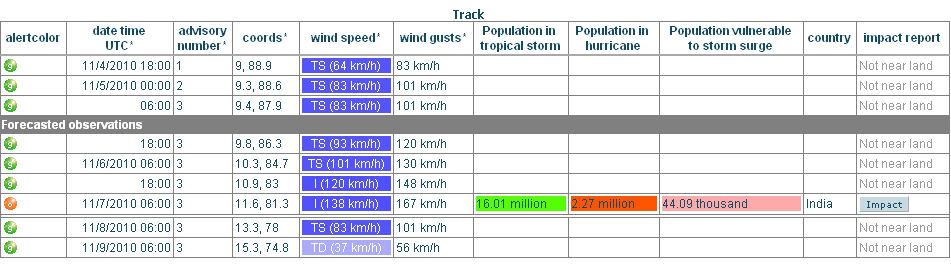
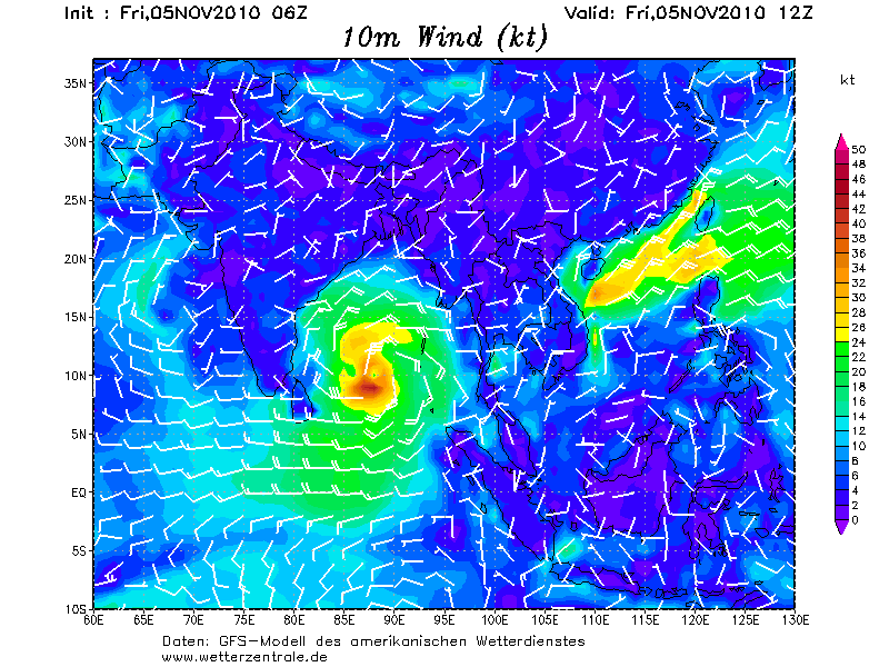
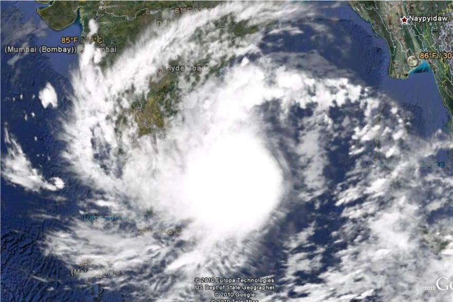
Er lijkt ook weer wat te ontstaan in de Indische Oceaan.
A tropical cyclone could bring damaging wind and flooding rain to eastern India at the end of the week.
As of Wednesday, a tropical weather system, formerly a tropical depression near the Malay Peninsula, was gathering over the Andaman Sea. This weather system will organize into a tropical depression and later, a tropical cyclone, over the open Bay of Bengal by Friday.
The latest information indicates that landfall of a cyclone of tropical storm or even hurricane strength is projected to take place on or about Sunday. It is likely landfall would be in the southeastern state of Andhra Pradesh.
The greatest threat to life and property will stem from torrential rain and flooding, especially near the coast.
Also a threat will be damaging winds and even a flooding storm tide.
This tropical weather system already has a history of adverse weather. It triggered flooding rain over southernmost Thailand on Sunday and Monday.
[ Bericht 3% gewijzigd door #ANONIEM op 04-11-2010 19:16:51 ]

A tropical cyclone could bring damaging wind and flooding rain to eastern India at the end of the week.
As of Wednesday, a tropical weather system, formerly a tropical depression near the Malay Peninsula, was gathering over the Andaman Sea. This weather system will organize into a tropical depression and later, a tropical cyclone, over the open Bay of Bengal by Friday.

The latest information indicates that landfall of a cyclone of tropical storm or even hurricane strength is projected to take place on or about Sunday. It is likely landfall would be in the southeastern state of Andhra Pradesh.
The greatest threat to life and property will stem from torrential rain and flooding, especially near the coast.
Also a threat will be damaging winds and even a flooding storm tide.
This tropical weather system already has a history of adverse weather. It triggered flooding rain over southernmost Thailand on Sunday and Monday.
[ Bericht 3% gewijzigd door #ANONIEM op 04-11-2010 19:16:51 ]
Lijkt weer wat te ontstaan op dinsdag. Even afwachten wat dat gaat worden.quote:Op donderdag 4 november 2010 15:23 schreef Burnie88 het volgende:
Staat nog niks op de kaart toch aloa? Ik ben benieuwd, Thomas wordt ook weer een lachertje, dus hoop nog steeds op een cat. 4 of 5 in de Golf.
http://weather.myfoxtampa(...)s/gfs_caribbean.html

De orkaan in de Indische Oceaan gaat voor veel ellende zorgen in India. Landfall als een categorie 1.
[ Bericht 0% gewijzigd door #ANONIEM op 05-11-2010 12:39:08 ]
[ Bericht 0% gewijzigd door #ANONIEM op 05-11-2010 12:39:08 ]
quote:Jal to intensify further, cross TN, AP coast on Sunday night
The severe cyclonic storm Jal, stationary about 550 kms from Chennai, would further intensify and cross the Tamil Nadu and Andhra Pradesh coast tomorrow night, the regional weather office said here today.
JAL remained stationary and lay centered over southwest Bay of Bengal at about 450 km east-northeast of Trincomalee (Sri Lanka), 550 km east-southeast of Chennai and 700 km southeast of Nellore, they said.
The cyclone would intensify further, move in a west-northwestwards direction and cross north Tamil Nadu and south Andhra Pradesh coasts between Puducherry and Nellore close to Chennai by Sunday night, they said.
Rain or thundershowers would occur at most places with isolated heavy to very heavy rain fall over north coastal Tamil Nadu, Puducherry and south coastal Andhra Pradesh in the next 24 hours, beginning 8.30 AM today.
South coastal Tamil Nadu would witness widespread rain over the next 48 hours, the weather office said.
Wind speed reaching between 60-80 kmph would prevail along and off North Tamil Nadu, Puducherry and south Andhra Pradesh coast from today and it might increase to 120-130 kmph to 140 kmph at the time of landfall, it said.
Sea conditions would be very rough to high. Storm surge may inundate low lying areas of Nellore and Prakasam districts of Andhra Pradesh and Tiruvallur, Chennai and Kanchipuram districts at the time of landfall, it said.
'The system is under constant surveillance and concerned state governments are being informed,' the weather office said.
Sri Lanka is niet meer te zien... daar zal ook veel regen vallen.
Jal is nu een cat 1 en zal zondag landfall maken op India.
[ Bericht 20% gewijzigd door #ANONIEM op 06-11-2010 20:18:40 ]
Jal is nu een cat 1 en zal zondag landfall maken op India.
[ Bericht 20% gewijzigd door #ANONIEM op 06-11-2010 20:18:40 ]


Ontstaat er nou nog iets? Originele plek ook...
http://www.opnaardehorizon.blogspot.com, mijn reisblog over 6 maanden Zuidoost-Azië

Er lijkt weer een systeem te ontstaan ten oosten van India
quote:Last Monday, AccuWeather.com first warned that southeastern India would become the target of another tropical cyclone this week. Signs continue to point toward this scenario unfolding.
The system that bears watching by the AccuWeather.com Hurricane Center is churning over the Bay of Bengal. The system will likely continue to track westward, reaching the southeastern coast of India during the first half of this week.
Prior to moving into India, the system should gain at least tropical depression or storm strength. This system is becoming better organized; however, moderate wind shear (strong winds high in the atmosphere) to the northwest of the system continues to prevent tropical development.
The waters of the Bay of Bengal are more than sufficiently warm enough to support tropical development. Wind shear is expected to decrease slightly over the next 24-48 hours and this will also prove conducive for tropical formation.
Since the exact track of this system is not set in stone, all residents along the southeastern coast of India should remain on alert.
The threat zone includes the same area struck by Tropical Cyclone Jal only a week ago.
At the very least, the system this week will endanger southeastern India with heavy rainfall. As the system's strength increases, so will the threat of damaging winds.

Voor de kust van Somalie lijkt ook weer een storm te ontstaan.
Op de lange termijn gaat deze waarschijnlijk richting India/Pakistan
[ Bericht 37% gewijzigd door #ANONIEM op 02-12-2010 16:26:19 ]
Op de lange termijn gaat deze waarschijnlijk richting India/Pakistan
[ Bericht 37% gewijzigd door #ANONIEM op 02-12-2010 16:26:19 ]
Interessant... voor 2010 werd een boven gemiddeld orkaanseizoen voorspeld... toch leek dat eigenlijk niet zo, want de US werd zo goed als niet getroffen, maar toch waren er aardig wat stormen.
Voor 2011 voorspellen ze nu een zeer agressief orkaanseizoen
Voor 2011 voorspellen ze nu een zeer agressief orkaanseizoen
Lees hier meer over deze voorspellingquote:CSU and TSR predict an extremely active 2011 Atlantic hurricane season
A continuation of the pattern of much above-average Atlantic hurricane activity we've seen since 1995 is on tap for 2011, according to the latest seasonal forecast issued Wednesday by Dr. Phil Klotzbach and Dr. Bill Gray of Colorado State University (CSU). They are calling for 17 named storms, 9 hurricanes, and 5 intense hurricanes. An average season has 10 - 11 named storms, 6 hurricanes, and 2 intense hurricanes. The new forecast is a very aggressive one, since only six seasons since 1851 have had as many as 17 named storms; 19 seasons have had 9 or more hurricanes. The 2011 forecast calls for a much above-average chance of a major hurricane hitting the U.S., both along the East Coast (49% chance, 31% chance is average) and the Gulf Coast (48% chance, 30% chance is average). The Caribbean is forecast to have a 62% chance of seeing at least one major hurricane (42% is average.) Five years with similar pre-season November atmospheric and oceanic conditions were selected as "analogue" years that the 2011 hurricane season may resemble: 2008, 1999, 1989, 1961, and 1956. The average activity for these years was 12 named storms, 7 hurricanes, and 4 major hurricanes.
The forecasters cited several reasons for their forecast of a much above-average season:
1) Unusually warm sea surface temperatures continue in the tropical Atlantic this fall, an indication that the active hurricane period we have been in since 1995 will continue (in technical terms, the positive phase of the Atlantic Multidecadal Oscillation, AMO, will continue.) SSTs in Atlantic Main Development Region (MDR) for hurricanes, from the Caribbean eastwards to the coast of Africa, were at a record high in October (November data are not yet available.)
2) Hurricane activity in the Atlantic is lowest during El Niño years and highest during La Niña or neutral years. This occurs because El Niño events tend to increase westerly upper-level winds over the tropical Atlantic, bringing high wind shear harmful for hurricanes. The CSU team notes that we are currently experiencing moderate to strong La Niña conditions, with an unusual amount of cool water present in the top 300 meters of the Equatorial Pacific Ocean off the coast of South America. Since 1979, only eight years have had similar amounts of cool water in November. The hurricane seasons that followed each of those eight years were unable to transition to El Niño conditions. Thus, the CSU team expects that we will have neutral or La Niña conditions in place for the Atlantic hurricane season of 2011, which should act to keep wind shear values average to below average, enhancing hurricane activity. Of the 16 El Niño/La Niña computer models that made November predictions for the July-August-September 2011 portion of hurricane season (Figure 1), only 4 (25%) predicted that El Niño would arrive.
2011 Atlantic hurricane season forecast from Tropical Storm Risk, Inc.
The British private forecasting firm Tropical Storm Risk, Inc. (TSR), issued their 2011 Atlantic hurricane season forecast on Monday. They are also calling for a very active year: 15.6 named storms, 8.4 hurricanes, and 4 intense hurricanes. TSR predicts a 66% chance of an above-average hurricane season, 22% chance of a near-normal season, and only a 12% chance of a below normal season. TSR bases their December forecast on predictions that sea surface temperatures next fall in the tropical Atlantic will be above about 0.3°C above average, and trade wind speeds will be about 0.7 m/s slower than average. The trade wind speed prediction is based on a forecast for a weak La Niña in August-September 2011.
I like how TSR puts their skill level right next to the forecast numbers: 2% skill above chance at forecasting the number of named storms, 1% skill for hurricanes, and 7% skill for intense hurricanes. That's not much skill, and really, we have to wait until the June 1 forecasts by CSU, NOAA, and TSR to get a forecast with reasonable skill.
Die voorspelling is mooi op tijd.quote:
Interessant... voor 2010 werd een boven gemiddeld orkaanseizoen voorspeld... toch leek dat eigenlijk niet zo, want de US werd zo goed als niet getroffen, maar toch waren er aardig wat stormen.
Voor 2011 voorspellen ze nu een zeer agressief orkaanseizoen
[..]
Lees hier meer over deze voorspelling
Tropische Depressie bij Vietnam

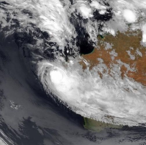
quote:Cyclone Threat to Northwest Australia
Broad tropical low pressure disturbing the Indian Ocean off northwestern Australia will pose a tropical cyclone threat to the region during the next few days.
As of Wednesday, eastern time, the center of tropical low pressure lay about 400 miles, or less than 700 km, off North West Cape, Australia.
Warm surface waters will allow this weather system to organize further as it drifts southeastward. It could hold tropical cyclone status as it bears down on the coast late in the week.
A tropical weather system off northwestern Australia on Dec. 15, 2010. (credit: Navy Research Lab Monterey)
The area most likely to have a landfall by this weather system is rather sparsely settled. Nonetheless, it will be subject to torrential rain and flash flooding as well as damaging winds.
Seas off northwestern Australia yield oil and natural gas, so operators of offshore petroleum structures will be eyeing this weather system.
This evolving weather system may have already played a part in a tragic mishap that happened far to the northwest on Wednesday.
Rough seas whipped up by northwesterly winds spiraling toward this low pressure may have been instrumental in the deadly crash of a boat against rocky shore of Christmas Island.
quote:Vluchtelingenboot slaat stuk op Australisch eiland
Op een Australisch eiland zijn zeker 27 asielzoekers om het leven gekomen, nadat hun schip op de rotsen was stukgeslagen. De vluchtelingen waren van Indonesië op weg naar Christmas Island. Door het slechte weer kon de houten boot niet aanleggen en sloeg hij op de rotsen kapot. Er is weinig meer van de boot over.
Er waren waarschijnlijk zo'n 70 mensen aan boord, die allemaal in zee terechtkwamen. Er konden 42 mensen uit zee worden gehaald. Enkele asielzoekers worden nog vermist.
Ooggetuigen
Vlak na het ongeluk probeerden bewoners van Christmas Island mensen te redden door touwen en reddingsvesten over de kliffen te gooien.
Volgens ooggetuige Simon Prince, die vlak bij de plaats van het ongeluk woont, werd hij wakker van hulpgeroep, waarna hij naar de kliffen rende om te zien wat er aan de hand was.
"Er lagen lichamen in het water, kinderen, allemaal rommel. Dat beeld zal me nog wel een tijd bijblijven."
Irakezen
De asielzoekers zijn waarschijnlijk Irakezen. Vluchtelingen die naar Australië willen, kiezen vaak voor de oversteek naar Christmas Island, omdat die relatief kort is.
nos
[ Bericht 31% gewijzigd door #ANONIEM op 16-12-2010 19:56:55 ]
Tropical Storm TASHA

quote:Weakening Tasha offers brief respite
Authorities are urging motorists to avoid road travel as much as possible in northern Queensland due to flooding from ex tropical cyclone Tasha, despite an easing of the conditions in the state.
The category one system crossed the coast just south of Cairns about 5.30am this morning, but has now weakened into a monsoonal low.
Flash flooding is still predicted in some areas, but Wayne Coutts from Queensland's Emergency Management says conditions are easing.
"There's been flash flooding occurring for the last few hours and probably I'm hoping right at the moment we're on the cusp of the downfall of the rain. So the SES groups are reporting that it's not as heavy," he said.
But Emergency Management Queensland says flooding is the biggest concern for authorities over the next few days with between 100 and 200 mm of rain expected to cause more flooding.
Queensland's Emergency Services Minister, Neil Roberts, says about 2,000 people are affected by power blackouts and the SES is responding to more than 140 calls for help.
"Thankfully there have been no reports of injury, but we have had reports of house damage to at least one home in the mission beach area however," he said.
"There is still heavy rain in the area, lots of roads cut and we expect the rain to continue particularly in the far north over the next few days, and increasing at the system moves into the south-west in the southern parts of Queensland in the next few days as well."