WKN Weer, Klimaat en Natuurrampen
Lees alles over het onstuimige weer op onze planeet, volg orkanen en tornado's, zie hoe vulkanen uitbarsten en hoe Moeder Aarde beeft bij een aardbeving. Alles over de verwoestende kracht van onze planeet en tal van andere natuurverschijnselen.


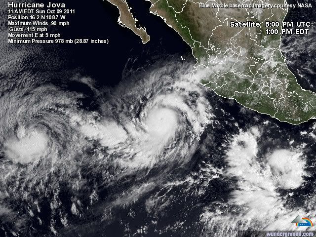

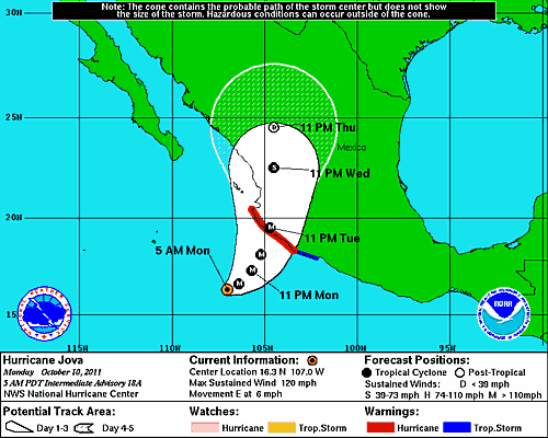
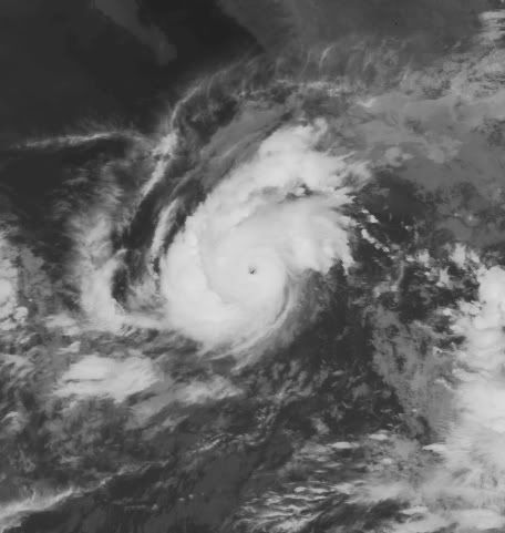
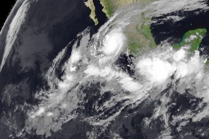
JOVA gaat nog een categorie 4 worden ook.
Momenteel een windsneleheid van 193 km/uur met windstoten tot 241 km/uur.
De orkaan beweegt zich voort met een snelheid van 6 km/uur, de kerndruk is 960 mb.
Inmiddels is er voor een groot gebied een orkaanwaarschuwing uitgegeven.
Momenteel een windsneleheid van 193 km/uur met windstoten tot 241 km/uur.
De orkaan beweegt zich voort met een snelheid van 6 km/uur, de kerndruk is 960 mb.
Inmiddels is er voor een groot gebied een orkaanwaarschuwing uitgegeven.

Eindelijk een verlichtend buitje voor het record droge Mexico en Texas zo te zien. Ze zullen er blij mee zijn.quote:Op maandag 10 oktober 2011 13:55 schreef aloa het volgende:
JOVA gaat nog een categorie 4 worden ook.
Momenteel een windsneleheid van 193 km/uur met windstoten tot 241 km/uur.
De orkaan beweegt zich voort met een snelheid van 6 km/uur, de kerndruk is 960 mb.
Inmiddels is er voor een groot gebied een orkaanwaarschuwing uitgegeven.
Texas gaat er niet veel van meekrijgen.quote:Op maandag 10 oktober 2011 17:08 schreef cynicus het volgende:
[..]
Eindelijk een verlichtend buitje voor het record droge Mexico en Texas zo te zien. Ze zullen er blij mee zijn.
Oh, nou dat zou voor de beleving van de gemiddelde Amerikaan wel eens gunstig kunnen zijn (ik bedoel: laat ze daar nog maar even in de droogte zitten en nog wat records breken). Shocktherapie Is goed voor hun gewaarwording...quote:
Nieuw syteem voor Mexico en Guatemala. Het lijkt erop dat dit geen orkaan gaat worden, maar zal wel voor veel neerslag gaan zorgen.
quote:JOVA kills four in Mexico
At least four people were killed on Wednesday when Hurricane Jova made landfall in western Mexico, officials said. The storm has since weakened to a tropical depression.
All four deaths were reported in the state of Jalisco where Jova made landfall on late Tuesday evening with maximum sustained winds near 100 miles (160 kilometers) per hour, making it a category two hurricane on the five-step Saffir-Simpson scale of intensity.
Two fatalities were reported in the municipality of Cihuatlan where a house collapsed, killing a 21-year-old woman named Norma Irene Rebolledo and her 5-year-old daughter Yolanda Marisol Rebolledo. Cihuatlan is located on the southern coast of Jalisco.
Two other fatalities were reported in the Jose Maria Morelos community, located in the municipality of Tomatlan, where a landslide killed a woman and her 13-year-old son. Tomatlan is located in the northern part of Jalisco.
Access to several communities, including Cihuatlan, La Huerta, Villa Purificacion, Autlan and Cuautitlan de Garcia Barragan was cut off due to water overflowing from the Marabasco River and at least ten connecting creeks.
In Cihuatlan alone, around 5,000 people have been displaced, the municipality’s Secretary General Fermin Alvarez Zamora said. As of Wednesday, more than 1,500 people were living at 70 temporary refugee camps which have been set up in the north and southern regions of Jalisco.
State Civil Protection emergency teams used helicopters to rescue at least 19 people in the affected areas, and it was not immediately clear if the death toll could still rise. Officials said electricity was knocked out in several parts of the states of Jalisco, Colima, Michoacan, Nayartit, and Sinaloa, affecting some 107,000 people.
As of Wednesday afternoon, Jova was located about 20 miles (35 kilometers) east-southeast of Tepic, the capital and largest city of the Mexican state of Nayarit. The system has weakened to a tropical depression with maximum sustained winds near 35 miles (55 kilometers) per hour, with higher gusts.
“Joda has weakened significantly during the past several hours,” said Jack Beven, a senior hurricane specialist at the U.S. National Hurricane Center (NHC). “The central convection has completely dissipated, there are no surface observations of tropical-storm-force winds, and [recent data] showed no tropical-storm-force winds over water west of the center. It is estimated that the cyclone has weakened to a tropical depression, although some gusts to tropical-storm-force are possible in mountainous areas for the next few hours.”
He added: “Although Jova has weakened, inland flooding over Mexico will remain a major concern. Heavy rains due to Jova are likely to continue across portions of western Mexico due to the relatively slow movement of the cyclone and upslope flow into the mountainous terrain. These rains will likely cause dangerous flash floods and mud slides.”
Jova is the ninth named storm of the 2011 Eastern Pacific hurricane season. It was followed by Hurricane Irwin which remains active as a tropical storm, about 415 miles (670 kilometers) south of the southern tip of Baja California, and the system could affect the same area as Jova on Thursday.
According to figures released in May, NOAA’s Climate Prediction Center is expecting a below normal hurricane season in the Eastern Pacific this year. The outlook calls for 9 to 15 named storms, with five to eight becoming hurricanes and one to three expected to become a major hurricane (category 3 or higher).
An average Eastern Pacific hurricane season produces 15 to 16 named storms, with eight to nine becoming hurricanes and four becoming major hurricanes. The Eastern Pacific hurricane season runs from May 15 through November 30, with peak activity from July through September.
quote:Negen doden bij nieuwe tropische storm op de Filipijnen
Bij een nieuw storm op de Filipijnen zijn in het centrum en het zuiden van het land zeker negen mensen om het leven gekomen. Dat heeft de civiele bescherming vandaag meegedeeld. Meer dan 23.000 mensen zijn getroffen door tropische storm Banya, die gisteren aan land kwam.
Volgens de civiele bescherming zijn duizenden reizigers gestrand door het stilleggen van het scheepsverkeer en de annulering van 48 binnenlandse vluchten. Verwacht wordt dat de storm komend weekend over de noordwestelijke provincies en hoofdstad Manila trekt.
Twee weken geleden kwamen 101 mensen om het leven nadat twee tyfoons vlak na elkaar over het noorden en oosten van de Filipijnen waren getrokken. (afp/adv)

Tientallen doden door noodweer Midden-Amerika
PANAMA-STAD (ANP) - Hevig noodweer heeft binnen een etmaal aan meer dan 20 mensen het leven gekost in Guatemala, Nicaragua en El Salvador. Ook Costa Rica en Honduras zijn getroffen door overstromingen.
Dit is woensdag (plaatselijke tijd) vernomen van de autoriteiten van de Midden-Amerikaanse landen. Het zwaarst getroffen is Guatemala, waar zeker 16 doden vielen, onder wie 4 kinderen. Duizenden mensen moesten worden geëvacueerd.
Elsevier
@Accuweatherquote:Deadly Week in the Tropics
It has been a deadly week with Hurricane Jova and once-Tropical Storm Banyan slamming onshore and a short-lived tropical depression unleashing flooding rain.
At the end of Wednesday, Jova was responsible for claiming at least five lives across western Mexico as the depression (T.D. 12-E) took 13 lives in Guatemala.
At least six lives were lost when once-Tropical Storm Banyan slammed the Philippines Monday into Wednesday.
Most of deaths from Jova and T.D. 12-E were at the hands of torrential rain, according to the Associated Press.
Jova's heavy rain drenched western Mexico late Tuesday into Wednesday. More than 11 inches of rain inundated Manzanillo with nearly 14 inches in the neighboring city of Colima.
The inundation triggered flooding and mudslides. One such mudslide in the town of Cihuatlan swept away a home along a hillside, killing a young woman and her daughter.
Also in Cihuatlan, 4 feet of flood waters filled a Red Cross office and forced evacuations.
The Associated Press reports that two other people died after being crushed by a wall of their home in the town of Tomatlan. Jova's rain had softened the wall, leading to its collapse.
Jova officially made landfall near the town of Chamela in the western Mexican state of Jalisco around 11 p.m. Tuesday (PDT, 2 a.m. EDT Wednesday).
A Category 2 hurricane, Jova was producing maximum sustained winds of nearly 100 mph at that time.
Soon after Jova came onshore, Tropical Depression 12-E took shape in the Gulf of Tehuantepec (offshore of southeastern Mexico).
The depression would move inland and weaken to a tropical rainstorm less than 24 hours later, but it had enough time to turn deadly as its heavy rain streamed into southeastern Mexico and neighboring Guatemala.
Guatemalan President Alvara Colom told the Associated Press that at least four of the 13 people that died in his country were electrocuted. Others died in mudslides and raging rivers.
Tapachula, the Mexican city located near the southern border of Guatemala, picked up nearly 4 inches of the depression's rain in 24 hours, ending late Wednesday.
The good news is that the tropical eastern Pacific is much quieter than at this time Wednesday. Irwin is the only tropical system still roaming the waters of the eastern Pacific and will continue to weaken today.
The Atlantic Basin remains void of organized tropical systems, but the AccuWeather.com Hurricane Center is monitoring the potential for that to change next week.
quote:16 killed in Guatemala
At least sixteen people were killed on Wednesday when torrential rains from a tropical depression hit several regions of Guatemala, officials said. The death toll is expected to rise.
Tropical Depression 12-E formed near the Mexico-Guatemala border on early Wednesday morning, about 150 miles (240 kilometers) southeast of Salina Cruz in Mexico, triggering Guatemala’s National Disaster Reduction Coordination Center to activate a nationwide red alert.
The heavy rainfall began on Tuesday night and continued into Wednesday, causing landslides, overflowing rivers, and accidents. The depression is expected to weaken and dissipate on Wednesday evening, forecasters said, but the harsh weather is expected to continue into Thursday.
Among the 16 confirmed deaths in Guatemala, four were electrocuted and one was buried in the municipality of Almolonga in the Quetzaltenango department. Several others died after their homes collapsed, while rescue workers recovered a couple of bodies from a river in Chiquimulilla, a municipality in the Santa Rosa department.
The most affected regions include Quetzaltenango, Santa Rosa, Jutiapa, and Totonicapan, as well as other scattered areas in the country. More than 130,000 people in Guatemala have been affected by the severe weather, but there were no immediate reports of casualties from Mexico.
Guatemalan President Alvaro Colom, who offered his condolences, has called on residents around the country to be extra careful.
Tropical Storm Possible in Gulf This Week
A large area of rain and thunderstorms near the Yucatan Peninsula may become the next tropical storm of this season. Despite uncertainty on the exact development, heavy rain is likely heading toward Florida.
An area of low pressure, a good indicator for possible tropical development, will park itself over the Yucatan through Monday. The low may have a tough time organizing into a tropical depression or storm this week given its close proximity to land. However, warm water across the Gulf of Mexico may be enough to foster tropical development.
No matter what comes of this potential tropical development, it seems heavy rain will target the Southeast, especially Florida, by the middle of this week.
"Regardless of which scenario pans out, much of the Florida peninsula may receive 2 to 4 inches of rain, with locally higher amounts," said Senior Meteorologist Danny Pydynowski.
The leading edge of a widespread heavy rain for Florida could move in as soon as Tuesday and persist into Wednesday.
Although a developing tropical system will remain a concern this week, the peak intensity would likely be a tropical storm. There are no significant indicators that a hurricane is plausible.
Some of the tropical moisture associated with the area of concern near the Yucatan may get pulled into the "wild" storm headed for the Northeast Wednesday.
@Accuweather
A large area of rain and thunderstorms near the Yucatan Peninsula may become the next tropical storm of this season. Despite uncertainty on the exact development, heavy rain is likely heading toward Florida.
An area of low pressure, a good indicator for possible tropical development, will park itself over the Yucatan through Monday. The low may have a tough time organizing into a tropical depression or storm this week given its close proximity to land. However, warm water across the Gulf of Mexico may be enough to foster tropical development.
No matter what comes of this potential tropical development, it seems heavy rain will target the Southeast, especially Florida, by the middle of this week.
"Regardless of which scenario pans out, much of the Florida peninsula may receive 2 to 4 inches of rain, with locally higher amounts," said Senior Meteorologist Danny Pydynowski.

The leading edge of a widespread heavy rain for Florida could move in as soon as Tuesday and persist into Wednesday.
Although a developing tropical system will remain a concern this week, the peak intensity would likely be a tropical storm. There are no significant indicators that a hurricane is plausible.
Some of the tropical moisture associated with the area of concern near the Yucatan may get pulled into the "wild" storm headed for the Northeast Wednesday.
@Accuweather
quote:Tientallen doden door noodweer Midden-Amerika
SAN SALVADOR - Tientallen mensen zijn in Midden-Amerika omgekomen bij overstromingen en aardverschuivingen veroorzaakt door zes dagen van zware regenval. Dat hebben de autoriteiten gezegd. Er is meer regen op komst.
Tientallen doden door noodweer Midden-Amerika
In El Salvador kwamen 24 mensen om toen hun huizen werden bedolven door aardverschuivingen. Mensen die op de flanken van de vulkaan San Salvador wonen zijn geëvacueerd, aldus een regeringswoordvoerder. In 1982 kostten aardverschuivingen daar aan honderden mensen het leven.
In Guatemala, waar zeker 23 mensen zijn omgekomen, heeft de president de noodtoestand uitgeroepen. In Honduras kwamen negen mensen om en zijn meer dan duizend mensen geëvacueerd. In Nicaragua, waar de regen inmiddels afneemt, kostte het noodweer aan vijf mensen het leven.

60% inmiddelsquote:
Tropical Storm Possible in Gulf This Week
@Accuweather


Dit kan wel een gevaarlijk systeem worden in de Caribische zee. 30% nu, maar deze maakt wel kans op orkaankracht.
[ Bericht 37% gewijzigd door #ANONIEM op 21-10-2011 14:31:28 ]
[ Bericht 37% gewijzigd door #ANONIEM op 21-10-2011 14:31:28 ]

Weinig windshear, waardoor het systeem zich goed kan ontwikkelen.
Watertemperatuur ligt rond de 30 graden.
Watertemperatuur ligt rond de 30 graden.
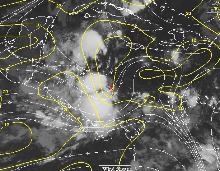
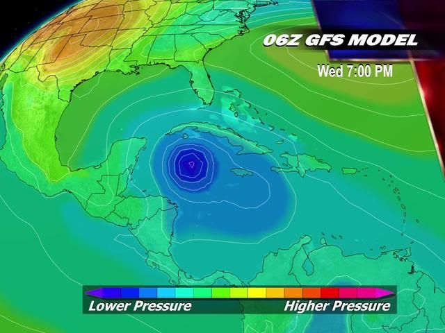
Western Caribbean disturbance 96L growing more organized
A region of disturbed weather in the Western Caribbean (Invest 96L) is bringing heavy rains to coastal Nicaragua, and has the potential to develop into a tropical depression this weekend. Visible satellite loops show that 96L is beginning to show signs of organization. Some rotation is apparent, and the upper-level cirrus clouds streaming away from the center indicate that 96L is establishing an upper-level outflow channel to the east. The heavy thunderstorm activity is quite limited at present, because a large region of dry air to the east of 96L is interfering with development, as seen on water vapor satellite loops. An ASCAT pass at 11:05 am EDT showed no signs of a surface circulation, with surface winds in the 25 - 30 mph range. Surface pressures are slowly falling at San Andres Island, near the center of 96L. Wind shear is a moderate 10 - 20 knots in the region, and is expected remain in the moderate range through Monday. Water temperatures are very warm, 29 - 30°C, and these warm waters extend to great depth.
Forecast for 96L
The moderate wind shear and warm waters should allow some modest development of 96L over the next few days, though this will be slowed by the dry air to the storm's east. The models are quite enthusiastic about developing 96L into a tropical depression, and our top four reliable models for forecasting genesis--the ECMWF, GFS, UKMET, and NOGAPS--have all been predicting formation of a tropical depression by Monday in one or more of their runs over the past day. 96L is in an area of weak steering currents, and will move little over the next three days. On Tuesday and Wednesday, a strong trough of low pressure will be passing over the Eastern U.S., and this trough has the potential to turn 96L northwards into Cuba. This is more likely to happen if 96L is stronger and deeper, and thus able to "feel" the upper-level winds the trough will bring. The 12Z run of the GFS model and 00Z runs of the ECMWF and UKMET models predict 96L will develop into a tropical storm that hits Western Cuba on Wednesday or Thursday, and potentially affecting the Cayman Islands, South Florida, and the Bahamas as well. If 96L remains a weak and shallow system, it is more likely to stay trapped in the Western Caribbean and make landfall in Nicaragua. This is the solution of the NOGAPS model, which has 96L moving ashore on Tuesday over Nicaragua as a weak system. NHC gave 96L a 30% chance of developing into a tropical depression by Sunday in their 8 am Tropical Weather Outlook. A hurricane hunter mission is scheduled to investigate 96L Saturday afternoon.
I'll have a new post on Saturday, but might wait until the afternoon, when the hurricane hunter data becomes available.
Jeff Masters