WKN Weer, Klimaat en Natuurrampen
Lees alles over het onstuimige weer op onze planeet, volg orkanen en tornado's, zie hoe vulkanen uitbarsten en hoe Moeder Aarde beeft bij een aardbeving. Alles over de verwoestende kracht van onze planeet en tal van andere natuurverschijnselen.


Hier is dan het nieuwe topic voor Hurricane Season 2007 voor zowel Atlantische, Indische als Pacifische stormen.
Algemene Info
Met de term 'Hurricane Season' bedoelden we in eerste instante de periode van 1 juni tot 30 november.
Deze periode wordt in het Atlantische basin en de Golf van Mexico gezien als het “Stormen-seizoen Echter komen deze geweldadige stormen overal in de wereld voor en met name in Azie zorgen ze jaarlijks voor honderden slachtoffers en duizenden daklozen. Echter horen we erg weinig over de stormen in Azie en juist meer over die in de VS.
Naar aanleiding van documentairs over Hurricane Andrew 1992 en de newsberichten van de laatste jaren over o.a. Floyd, Stan en Ivan en natuurlijk de catastrofe "Katrina" beginnen we ook voor 2007 met een nieuw topic. Hoewel het Amerikaanse seizoen pas in Juni begint zijn er op andere plekken in de wereld zeker meer orkanen te vinden in de komende maanden. We zullen ook deze dus zeker gaan bespreken. Waarschijnlijk zal de kern van de discussie en de posts gaan over de periode 1-6-2006 t/m 30-11-2006. Daarvoor zal het wel niet storm gaan lopen
Waarschijnlijk zal er t.z.t. ook wel een NWS-topic worden geopend als een orkaan ook uitgebreid in het nieuws.
Hoe ontstaan ze?
op de site van Wikipedia kan je in het Nederlands nalezen hoe ze ontstaan en wat de belangrijkste energiebron is voor hun verwoestende kracht: het warme zeewater http://nl.wikipedia.org/wiki/Orkaan#Ontstaan
De BBC heeft er een interessante en leuke gif over gemaakt (met dank aan Roel)
http://news.bbc.co.uk/2/hi/science/nature/4588149.stm
Ook wordt er op LiveScience in het engels prima uitgelegd hoe ze ontstaan en zich ontwikkelen http://www.livescience.co(...)icane_formation.html
Indeling en Kracht
De stormen worden ingedeeld op categorie. Vaak zijn het eerst "tropische stormen" (Tropical Depression, Tropical Storms), die overgaan op Orkaanstatus (Hurricane) Ze worden ingedeeld op windsnelheden via de Saffire Simpson Schaal
Tropical Depression 24-38 mph winds (38-61 km/u)
Tropical Storm 39-73 mph winds (62-118 km/u)
Hurricane Categorie 1 74-95 mph winds (119-153 km/u) -- 4/5 ft Storm Surge -- Vb. Danny 1997, Stan 2005
Hurricane Categorie 2 96-110 mph winds (154-177 km/u) - 6/8 ft Storm Surge -- Vb. Danielle 2004
Hurricane Categorie 3 111-130 mph winds (178-209 km/u) -- 9/12 ft Storm Surge -- Vb.Fran 1996, Beta 2005
Hurricane Categorie 4 131-155 mph winds (210-249 km/u) -- 13/18 ft Storm Surge -- Vb.Hugo 1989, Frances 2004
Hurricane Categorie 5 > 156 mph winds (meer dan 250 km/u) -- 18ft or more S.S. -- Vb.Andrew 1992, Mitch 1998 en Wilma, Katrina 2005
Namen
De stormen, die vaak gevormd worden op de atlantische oceaan en dan richting de Caribbean of de Oostkust van de VS gaan, krijgen de naam op Alfabetische volgorde. Voor het seizoen 2005 zijn de namen als volgt:
Atlantische Stormen 2007
Andrea, Barry, Chantal, Dean, Erin, Felix, Gabrielle, Humberto, Ingrid, Jerry, Karen, Lorenzo, Melissa, Noel, Olga, Pablo, Rebekah, Sebastien, Tanya, Van, Wendy
In het oosten van de pacific ontstaan ook Hurricanes, ook wel Cylonen en/of Tyfoons genoemd. Deze zorgen vaak voor weinig schade aan de Amerikaanse westkust.
Oost Pacifische Stormen 2007
Alvin, Barbara, Cosme, Dalia, Erick, Flossie, Gil, Henriette, Ivo, Juliette, Kiko, Lorena, Manuel, Narda, Octave, Priscilla, Raymond, Sonia, Tico, Velma, Wallis, Xina, York, Zelda
Verder zijn er dan nog de stormen in het Noorden, Zuiden en Westen van de Pacific. Met name de stormen in het Noord/Westen komen vaak in het nieuws omdat ze Japan, Taiwan en China vaak teisteren, maar ook geheel Zuid Oost Azie kunnen treffen. De namen van deze stormen zijn terug te vinden op
http://www.nhc.noaa.gov/aboutnames.shtml
Wanneer zijn die seizoenen nou precies?
ATLANTIC: 1 mei t/m 30 november
NORTH EAST PACIFIC Begin mei t/m begin November, met piek in Augustus/September
NORTH WEST PACIFIC Begin juli t/m eind November, maar eigenlijk hele jaar door aktiviteit.
NORTH INDIAN April t/m December met pieken in Mei en November
SOUTH INDIAN + WEST AUSTRALIAN Oktober t/m Mei met pieken in Februari en April
SOUTH WEST PACIFIC + EAST AUSTRALIANOktober tot eind April met piek in Februari.
Over het algemeen is Mei de rustigste maand en September de ergste.
Hoe ziet de voorspelling voor 2007 eruit
Volgens Phil Klotzbach en William Gray van CSU wordt 2007 een actief jaar dat ze 'boven gemiddeld' noemen. Deze 'voorlopige' voorspelling deden ze op 8 december 2006. Ze voorspellen dan ook dat er 14 stormen komen die een naam krijgen, waarvan er 7 uitgroeien tot een orkaan. Van deze zeven zijn er 3 van Categorie 3 of hoger.
Verder voorspellen ze dat er 64% kans is dat er een zware orkaan in 2007 het gebied rondom Florida treft en dat er 40% kans is dat een orkaan de Oostkust van de VS aan doet. Vooral dit laatste vrezen de Amerikanen al jaren, want een 'lichte' Categorie 1 of 2 storm zou voor miljarden schade kunnen doen aan de dichtbevolkte oostkust van de VS.
(PS: Vorig jaar zaten beide heren er heel erg naast... )
Oude Delen
2004 - Deel 1 Hurricane Season 2004 en Deel 2 Hurricane Season 2004 -- Part 2
2005 - Deel 1 Tropical Cyclone Season 2005 en Deel 2 Hurricane/Cyclone Season 2005 - Part 2
2006 - Deel 1 [WFL] Hurricane Season 2006 en Deel 2 Hurricane Season 2006 #2
Enkele Links
1. Hurricane Season Special Edition Pagina van CNN van 2006
2. National Hurricane Centre
3. Carribean Storm Network
4. Florida University Hurricane Website
5. Action News from Florida + Webcams
6. Hurricane Track
7. Website met satelietbeelden van de Caribbean en de rest van Amerika
8. Intellicast: Geavanceerde satellietfoto's en gifs van aktuele stormen
9. Data over temperatuur / wind
10. Tropical Storm Risico's van dit moment
11. Actuele Watertemperatuur van dit moment
12. Wikipedia Hurricanes/Tyfonen in het algemeen
13. Overzicht aktuele typhoons in de pacific
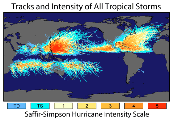
14. Alle stormen ter wereld van de laatste jaren in overzicht
15. The StormTrack
Opmerkelijke Links
-- Hurricane Katrina CNN Special Report of the Killer Hurricane
-- Hurricane Katrina via WikiPedia
-- Hurricane Season 2005 -- Special van CNN
-- Hurricane Season 2004 -- Special van CNN
– Overzicht van Atlantische Stormen uit 2005
-- Spectaculaire Satelietshots van stormen
--Animatie van de alle Atlantische Stormen uit 2004
Openingspost
Klik hier
Actuele Radar in Golf van Mexico

Water temperatuur.

Last Update: 28-05-2007
=====================
Post hier je gegevens, nieuwsberichten, data en/of opmerkelijke zaken over de ‘Hurricanes en Cyclonen’ van 2007
------------------------------------------------------------------
quote:Op donderdag 12 juli 2007 15:30 schreef Frutsel het volgende:
Windspeeds of Tyfoon Man-Yi
[afbeelding]
Typhoon Man-yi formed as a tropical depression in the western Pacific on July 8, 2007, among the islands of Micronesia. The storm gradually built power to typhoon status on July 10. As of July 11, forecasters were calling for Man-Yi to strengthen to Category 4 (Super Typhoon) status, with sustained winds in the storm’s core predicted to reach at least 210 kilometer per hour (131 miles per hour).
This data visualization of the storm shows observations form the QuikSCAT satellite on July 9, 2007, at 20:58 UTC (8:58 a.m. local time, July 10). At this time, Man-Yi appeared as a well-developed storm system, but had not yet reached typhoon status; it’s peak winds were around 110 km/hr (65 mph; 60 knots). The image depicts wind speed in color and wind direction with small barbs. White barbs point to areas of heavy rain.
QuikSCAT measurements of the wind strength of Man-Yi and other tropical cyclones can be slower than actual wind speeds. QuikSCAT’s scatterometer sends pulses of microwave energy through the atmosphere to the ocean surface and measures the energy that bounces back from the wind-roughened surface. The energy of the microwave pulses changes depending on wind speed and direction.
To relate the radar signal to actual wind speed, scientists compare measurements taken from buoys and other ground stations to data the satellite acquired at the same time and place. Because the high wind speeds generated by cyclones are rare, scientists do not have corresponding ground information to know how to translate data from the satellite for wind speeds above 50 knots (about 93 km/hr or 58 mph).
Also, the unusually heavy rain found in a cyclone distorts the microwave pulses in a number of ways, making a conversion to exact wind speed difficult. Instead, the scatterometer provides a nice picture of the relative wind speeds within the storm and shows wind direction.
naamtopic .quote:Op vrijdag 13 juli 2007 04:11 schreef speknek het volgende:
Argh, ik heb al een kaartje gekocht om zondagochtend vanaf Tokyo naar Zuid-Korea te vliegen (en hotel geboekt..), maar ik verwacht dat de vliegtuigen wel aan de grond zullen blijven. Grmbl. Beter blijft die typhoon nog even boven zuid-Japan hangen...
Opm DH : Nu niet meer....
Voorgaande topics (2007)
Game on.
[ Bericht 31% gewijzigd door Frutsel op 15-08-2007 12:00:04 ]
They told me all of my cages were mental, so I got wasted like all my potential.

whehe grmbl. Maar bedankt, was helemaal vergeten dat ie ook een OP had .
They told me all of my cages were mental, so I got wasted like all my potential.
Drugshond? Zou je mij even de OP willen sturen? De OP text in het begin post bestaat niet meer, stond nog op mijn oude domein naam. Of misschien handiger om een wiki hiervan te maken
<a href="https://www.youtube.com/channel/UCPueUwKfPaGH7v48LZlltkg" rel="nofollow" target="_blank">WSDokkum Youtube</a>

Donequote:Op vrijdag 13 juli 2007 09:28 schreef SpeedyGJ het volgende:
Drugshond? Zou je mij even de OP willen sturen? De OP text in het begin post bestaat niet meer, stond nog op mijn oude domein naam. Of misschien handiger om een wiki hiervan te maken
Misschien even in code tags nu moet ik alle links e.d over typen sorry ik ben zelf wat aan de drukke kant momenteelquote:
<a href="https://www.youtube.com/channel/UCPueUwKfPaGH7v48LZlltkg" rel="nofollow" target="_blank">WSDokkum Youtube</a>

Typhoon Man-Yi (down to 110 mph) has passed Okinawa.
Wind gusts were measured to 105 mph and many of the island's households are reported to be without power.
Very destructive winds, storm surge, and high waves will continue to impact nearby islands.
Man-Yi is forecast to recurve rapidly and head just north of east raking the larger islands of southern Japan, although the storm's winds will begin to slacken by then. Huge surf of 25 to 30 feet will pound the southern third of Japan over the next day and a half, causing major problems for boats and coastal structures. Wind damage and flooding rains will be ongoing concerns.
Man-Yi should be very close to Tokyo by early Sunday (U. S. time), but probably will be only a strong tropical storm by that point.
foto van vrijdag 12.00 uur.
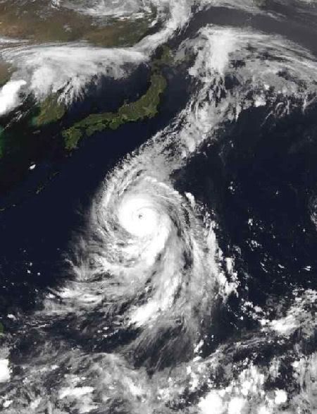
Typhoon Man-Yi
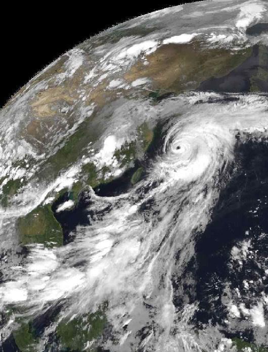
Typhoon Man-Yi was pummeling the Japanese island of Okinawa with winds between 230 and 295 kilometers per hour (125-160 knots, 144-184 miles per hour) and heavy rain on the morning of July 13, 2007, when the Moderate Resolution Imaging Spectroradiometer (MODIS) on NASA’s Terra satellite captured this image. The immense storm covered hundreds of kilometers with spiraling bands of thunderstorms, though it had lost the distinctive cloud-free eye it exhibited the day before.
Typhoons are common in Japan, but powerful typhoons usually strike the island nation later in the year. The Japan Meteorological Agency said that Man-Yi is the fourth typhoon of the 2007 season and may be the most powerful ever observed in the northwest Pacific in July, reported Kyodo News. The Joint Typhoon Warning Center expected the typhoon to strike Kyushu, a southern Japanese island, on July 14, and then curve northeast along the eastern shore of Japan. By the time the storm reaches Tokyo on July 15, it should be degraded to a tropical storm. As of July 13, Typhoon Man-Yi had injured eight and flooded twenty houses in Okinawa, and forced airlines to cancel hundreds of flights, said Kyodo News. The storm was expected to bring heavy rain to Japan’s Pacific coast.
bron:
[ Bericht 45% gewijzigd door #ANONIEM op 13-07-2007 20:09:56 ]
Wind gusts were measured to 105 mph and many of the island's households are reported to be without power.
Very destructive winds, storm surge, and high waves will continue to impact nearby islands.
Man-Yi is forecast to recurve rapidly and head just north of east raking the larger islands of southern Japan, although the storm's winds will begin to slacken by then. Huge surf of 25 to 30 feet will pound the southern third of Japan over the next day and a half, causing major problems for boats and coastal structures. Wind damage and flooding rains will be ongoing concerns.
Man-Yi should be very close to Tokyo by early Sunday (U. S. time), but probably will be only a strong tropical storm by that point.
foto van vrijdag 12.00 uur.

Typhoon Man-Yi
Typhoon Man-Yi was pummeling the Japanese island of Okinawa with winds between 230 and 295 kilometers per hour (125-160 knots, 144-184 miles per hour) and heavy rain on the morning of July 13, 2007, when the Moderate Resolution Imaging Spectroradiometer (MODIS) on NASA’s Terra satellite captured this image. The immense storm covered hundreds of kilometers with spiraling bands of thunderstorms, though it had lost the distinctive cloud-free eye it exhibited the day before.
Typhoons are common in Japan, but powerful typhoons usually strike the island nation later in the year. The Japan Meteorological Agency said that Man-Yi is the fourth typhoon of the 2007 season and may be the most powerful ever observed in the northwest Pacific in July, reported Kyodo News. The Joint Typhoon Warning Center expected the typhoon to strike Kyushu, a southern Japanese island, on July 14, and then curve northeast along the eastern shore of Japan. By the time the storm reaches Tokyo on July 15, it should be degraded to a tropical storm. As of July 13, Typhoon Man-Yi had injured eight and flooded twenty houses in Okinawa, and forced airlines to cancel hundreds of flights, said Kyodo News. The storm was expected to bring heavy rain to Japan’s Pacific coast.
bron:
[ Bericht 45% gewijzigd door #ANONIEM op 13-07-2007 20:09:56 ]

Nieuwe depressie in de East Pacific !
De verwachting is dat de depressie morgenochtend promoveert tot een minimaale tropische storm.
Het lijkt echter geen spectakel te worden.
En nog een nieuwe depressie !!
Ook deze is in de East Pacific !!
[ Bericht 15% gewijzigd door DForce op 14-07-2007 19:15:27 ]
De verwachting is dat de depressie morgenochtend promoveert tot een minimaale tropische storm.

Het lijkt echter geen spectakel te worden.
En nog een nieuwe depressie !!
Ook deze is in de East Pacific !!


[ Bericht 15% gewijzigd door DForce op 14-07-2007 19:15:27 ]
Japan getroffen door krachtige tyfoon
TOKIO - Het zuiden en zuidwesten van Japan zijn zaterdag getroffen door een zware tyfoon, de krachtigste in deze regio sinds 1951. Volgens Japanse media zijn tienduizenden mensen op de vlucht geslagen voor Man-yi. De autoriteiten meldden zeker twee doden en meer dan zestig gewonden.
Volgens het Japanse persbureau Kyodo zal het dodental vrijwel zeker oplopen. De windsnelheden liepen gedurende de dag op tot 215 kilometer per uur. Meteorologen verwachten dat ook andere delen van Japan door Man-yi gegeseld zullen worden, onder meer in de sterk verstedelijkte regio's Tokio en Osaka.
Het vliegverkeer in Japan is ernstig ontregeld. Vele honderden vluchten zijn geschrapt, waardoor naar schatting 60.000 passagiers strandden op verscheidene luchthavens. Bij honderdduizenden mensen viel de stroom uit.
Telegraaf
[ Bericht 22% gewijzigd door #ANONIEM op 14-07-2007 21:03:17 ]
Er komen niet veel orkanen langs Hawaii, volgens mij.quote:Op zaterdag 14 juli 2007 20:56 schreef highway101 het volgende:
Krijgt Hawaii nou vaak echte orkanen? Of vallen ze vaak buiten het hurricane gebied?
Typhoon Man-Yi (winds of 90 mph) is now impacting southern Japan.quote:Hier een artikel van Dinsdag 29 augustus 2006
Topper van de orkanen dit moment is Ioke. Niemand heeft eigenlijk van deze 10 dagen oude orkaan gehoord en dat heeft alles te maken met de koers die ze volgt. Deze supertyphoon trekt op een ongebruikelijke koers over de Grote Oceaan. In korte tijd ontwikkelde Ioke zich van een gewone storm tot een orkaan. Drie dagen later bereikte Ioke het supertyphoon status. Dagenlang al zwalkt Ioke over de Grote Oceaan met maximum winden van 260 km/uur en rukwinden tot 315 km/uur. Donderdag zal Ioke eindelijk iets afzwakken. Op de kaart met de trekroute van Ioke is te zien dat ze precies tussen Hawaii en de Marshall eilanden doortrok. Een hele opluchting vor de eilandbewoners, maar als orkaan ga je roemloos ten onder. Als er geen land bereikt wordt, is er weinig schade en dan heb je zelfs als supertyphoon geen nieuwswaarde.
Man-Yi is now moving northeast, passing just north of east of the larger islands of southern Japan. High surf, heavy rain, and strong gusty winds are now being felt.
A continued track to the northeast will bring impacts through Japan, particularly the south, and southeast coasts. This will bring the storm very close to Tokyo by early Sunday (U. S. time).
Man-Yi will continue to weaken, and will likely be only a strong tropical storm as it impacts areas near Tokyo, but the heavy rain, gusty winds, and high surf will continue.
Closer to home Atlantic Basin remains quiet.
In the eastern Pacific, about 1000 miles west-southwest of Acapulco, Mexico(well west of any land mass) a cluster of thunderstorms has developed into the fifth tropical depression of the season. Roughly 900 miles west of TD-5E is the newly formed sixth tropical depression of the season. Both storms are forecast to strengthen as they move away from the Mexican Coast.
bron:
Ik heb het geplaatst op de frontpage: Man-Yi raast over Japan Als jullie meer informatie hebben kunnen jullie me pm'en of aanspreken op IRC
Thx alot!quote:Op zondag 15 juli 2007 00:05 schreef colourAgga het volgende:
Ik heb het geplaatst op de frontpage: Man-Yi raast over Japan Als jullie meer informatie hebben kunnen jullie me pm'en of aanspreken op IRC
damn hoop dat alles goed gaat daar
vraag me alleen af wat de naam betekend, of eigenlijk wat "Yi" betekend (tenzij man-yi iets compleet anders is)
"man" betekend in ieder geval 10.000
moet k ook meteen denken aan die film jumanji.... jyuman is namelijk 100.000
vraag me alleen af wat de naam betekend, of eigenlijk wat "Yi" betekend (tenzij man-yi iets compleet anders is)
"man" betekend in ieder geval 10.000
moet k ook meteen denken aan die film jumanji.... jyuman is namelijk 100.000
If you want to see a picture of the future, imagine a boot stamping on a human face...forever.
man-yi was een rivier in Hong Kong. Voor alle namen van aziatische typhoons, zie:
http://www.jma.go.jp/jma/(...)p-pub-eg/tyname.html
Ik heb trouwens (in Yokohama en Nagoya) erg weinig gemerkt van deze, het regende maar de treinen reden op tijd (iets wat ze echt niet altijd doen) en vannacht waaide het een beetje.
De gemiddelde herftstorm in Nederland is erger.
http://www.jma.go.jp/jma/(...)p-pub-eg/tyname.html
Ik heb trouwens (in Yokohama en Nagoya) erg weinig gemerkt van deze, het regende maar de treinen reden op tijd (iets wat ze echt niet altijd doen) en vannacht waaide het een beetje.
De gemiddelde herftstorm in Nederland is erger.
Tyfoon gaat Tokyo voorbij
De zware tyfoon die sinds zaterdag over Japan raast, heeft Tokio tegen de verwachtingen in ongemoeid gelaten. De tyfoon Man-Yi kwam zaterdag in het zuiden van Japan aan land en kostte tot nog toe vijf mensen het leven, onder wie twee bejaarden en een 11-jarige jongen.
Zeker tachtig mensen zijn gewond geraakt. Vijftien huizen zijn verwoest en ongeveer vijftienhonderd woningen liepen onder water. Tienduizenden mensen werden geëvacueerd.
De tyfoon trekt nu in afgezwakte vorm met negentig kilometer per uur als een tropische storm in noordelijke richting. Volgens de autoriteiten is Man-Yi is de zwaarste juli-tyfoon ooit gemeten in Japan.

Sorry maar wat is daar nu zo cool aan?quote:Op zaterdag 14 juli 2007 17:25 schreef DForce het volgende:
Nieuwe depressie in de East Pacific !
Er zit denk k teveel poep in je oog want er staat nergens dat ik dat cool vind.quote:Op zondag 15 juli 2007 12:08 schreef Poepoog het volgende:
[..]
Sorry maar wat is daar nu zo cool aan?
quote:Op zondag 15 juli 2007 14:01 schreef DForce het volgende:
[..]
Er zit denk k teveel poep in je oog want er staat nergens dat ik dat cool vind.
quote:
En dit impliceert?quote:Het lijkt echter geen spectakel te worden.
In the eastern Pacific, between 1000 and 2000 miles west-southwest of Acapulco, Mexico, 2 tropical depressions, 5-E and 6-E, have formed. Tropical Depression 6-E has the best chance for becoming a tropical storm. Both depressions are heading westward across the open Pacific and pose no threat to any land mass.
Man-Yi has become extratropical and is racing away from Japan after leaving quite a legacy, especially across the southern end of the island nation.
The typhoon sank a Chinese freighter 400 miles NW of Guam with 9 lost with the ship. Man-Yi would go on to bring Okinawa 105 mph wind gusts with major loss of power. The storm then crossed into Kyushu with 80-90 mph winds and flooding rains and more widespread power outages. The storm's fury would injure 70 people and kill 5 on Kyushu. The typhoon weakened to a tropical storm but still brought 3-4 inches of rain to Tokyo and snarled train, plane, and car travel for several days. The system has now become extratropical and is moving rapidly away from the mainland with a threat only to shipping later today and tonight.
Atlantic Basin remains very quiet.

Orkanen boven Middellandse zee (Telegraaf/Trouw)
AMSTERDAM - Orkanen en andere ernstige tropische stormen gaan het gebied rond de Middellandse zee teisteren. Dat verwachten vooraanstaande Europese klimatologen.
Zware orkanen bereiken Europa nu meestal niet, maar met het veranderende klimaat komt de dreiging veel dichterbij. Als de temperatuur drie graden stijgt breekt de hel los en is de Middellandse zee zelf in staat orkanen te ontwikkelen.
Miguel Angel Gaertner van de universiteit in Toledo denkt dat de toerisme-industrie veel last gaat krijgen van het veranderende weer. Nu duiken typhoons al soms op op plaatsen die de meteorologen niet hadden verwacht. Volgens Gaertner is dat een eerste teken dat het mis gaat.
Als voorbeelden noemt hij de storm Catarina die zuid-Brazilië trof en Vince in de buurt van Madeira.
Volgens mij is de Mediterranean wel wat te klein voor grote orkanen...
Mwoah dat waren uitzonderingen. Kan er nog niet echt wakker van liggen.quote:Als voorbeelden noemt hij de storm Catarina die zuid-Brazilië trof en Vince in de buurt van Madeira.
/ ¦ ¦ / ¦ ¦
Ik vind dat we er dan een nieuwe naam voor moeten bedenken. Cyclonen, tyfonen en orkanen komen al ergens anders voor, dus voor het Middellandse zeegebied moeten we een nieuwe naam gaan bedenken.
Viaductenquote:Op maandag 16 juli 2007 18:29 schreef Eveli het volgende:
Ik vind dat we er dan een nieuwe naam voor moeten bedenken. Cyclonen, tyfonen en orkanen komen al ergens anders voor, dus voor het Middellandse zeegebied moeten we een nieuwe naam gaan bedenken.
Het is al een keer eerder voorgekomen, een orkaan in de middellandse zee. Alleen was die verre van krachtig, maar had wel de typische orkaan structuur verder, met oog en al
Drugs are good mkay?
Tropical Storm Cosme (75 mph) has grown a bit stronger. Cosme is located about 16oo miles ESE of Hilo, Hawaii, and moving toward the WNW at 10 mph.
Tomorrow, Cosme is expected to encounter cooler ocean waters that probably will initiate a gradual weakening trend. As Cosme approaches Hawaii this weekend, it may be nothing more than a depression or weak tropical storm
Tomorrow, Cosme is expected to encounter cooler ocean waters that probably will initiate a gradual weakening trend. As Cosme approaches Hawaii this weekend, it may be nothing more than a depression or weak tropical storm
Dan zal het eerder een tropische depressie of tropische storm geweest zijn, denk ik.quote:Op maandag 16 juli 2007 19:14 schreef Party_P het volgende:
Het is al een keer eerder voorgekomen, een orkaan in de middellandse zee. Alleen was die verre van krachtig, maar had wel de typische orkaan structuur verder, met oog en al
NOAA: La Nina voorlopig afwezig
Het is en blijft opvallend stil, wat Amerika en Orkanen betreft.quote:
NOAA heeft de verwachting uitgesproken dat La Nina voorlopig afwezig is. Daarmee gaat NOAA in tegen eerdere verwachtingen.
Voor de kust van Ecuador en Peru is het kouder dan normaal. Europese weermodellen gingen uit van een middelsterke La Nina. Amerikaanse weermodellen van een zwakkere La Nina. NOAA stelt nu haar verwachtingen bij tot geen La Nina.
Voor de orkaanverwachtingen op de Atlantische Oceaan betekent dit dat de kans op orkanen minder is. In La Nina-jaren zou deze activiteit beduidend minder zijn. Dit is echter geen garantie, want in het recordjaar 2005 bleek ook geen La Nina aanwezig te zijn en was het buitengewoon druk op de Atlantische Oceaan.
Voor dit jaar is een bovengemiddelde orkaanverwachting uitgegeven. Reden is dat we in een actieve periode zitten die in 1995 is begonnen en nog tot 2015/2020 duurt. Tot op dit moment zijn er echter nog maar twee systemen geweest. Andrea ontwikkelde zich in mei, nog voor de officiële start en Barry op de eerste dag van het orkaanseizoen.
idd... verdacht stil... juni is 'normaal'.... maar mag nu wel weer eens beginnen
Al is augustus-september piekmaand...
Al is augustus-september piekmaand...
Cosme downgraded
Once a hurricane, Cosme has weakened to a tropical depression, with sustained winds of 35 mph. In addition to the weaker winds, convection has waned as well. All is not lost for this tropical cyclone, however. It will be entering an area of weaker shear, and some slight regeneration is possible over the next day or two. Overall, though, the depression will continue to the west as a weak system.
Tropical Depression Cosme is expected to pass south of the island of Hawaii (the Big Island) by early this weekend. The system may do nothing more, however, than kick up 10- to 15-foot surf around the island, and increase the trade wind shower activity.
There are no imminent threats of tropical cyclone development in the Atlantic Basin.

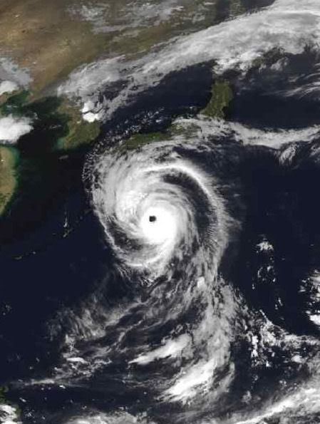
Hurricane Cosme
Hurricane Cosme was the third named storm in the 2007 Eastern Pacific hurricane season. Cosme formed in a common area for hurricanes to start—off the Pacific coast of Mexico—and it tracked north and west. Cosme built power from its initial Tropical Depression state on July 14 to a minimal Category 1 hurricane on July 16.
At 10:45 a.m. local time (19:45 UTC) on July 16, 2007, when the Moderate Resolution Imaging Spectroradiometer (MODIS) on NASA’s Terra satellite captured this image, Hurricane Cosme was at its brief peak as a Category 1 storm. The hurricane had a well-defined spiral shape, but it was relatively small and its central eye was filled with clouds (known as a “closed eye”). Sustained winds were measured at 120 kilometers per hour (75 miles per hour) according to the University of Hawaii’s Tropical Storm Information Center, at the time of this MODIS image.
Conditions for Hurricane Cosme to intensify were poor, and by July 17, it had downgraded back to tropical storm status. The storm was projected to continue on a mostly westward track toward Hawaii, according to the Joint Typhoon Warning Center on July 17, 2007. The forecast at that time called for Cosme to brush the Big Island of Hawaii on July 22 as a tropical storm
Cosme gaat richting Hawaii
Cosme bringing impacts to Hawaii
Tropical Depression Cosme continues on a westward track across the central Pacific, with sustained winds holding at 35 mph.
Cosme is expected to pass south of the Hawaiian Islands, but will be close enough to increase trade winds and trigger some locally heavy showers.
Flash flood watches have been posted for the Big Island, where multiple inches of rainfall are possible over the volcanic peaks.
High and rough surf (waves to between 12 and 16 feet) will also be on the increase.
In the Atlantic Basin, part of a tropical wave is drifting northward from Puerto Rico and the northern Lesser Antilles to interact with an upper-level low northeast of the Bahamas. A surface low could develop and bring showers to Bermuda in a few days.
Overall, shearing winds over the Gulf of Mexico and Caribbean Sea will prevent any development.
En een nieuwe storm ontstaat voor de westkust van Mexico, terwijl de Atlantic/Golf regio verdacht stil blijft
[ Bericht 11% gewijzigd door Frutsel op 23-07-2007 12:06:26 ]
[ Bericht 11% gewijzigd door Frutsel op 23-07-2007 12:06:26 ]
Nog wel ja, maar 1 dikke cat 5 aan land kan de hele stad alweer om zeep helpen, als is daar maar 1 orkaan voor nodig voor dit jaar.
<a href="https://www.youtube.com/channel/UCPueUwKfPaGH7v48LZlltkg" rel="nofollow" target="_blank">WSDokkum Youtube</a>
Zou wel sneu zijn als die dan weer over new orleans zou gaan.quote:Op maandag 23 juli 2007 13:33 schreef SpeedyGJ het volgende:
Nog wel ja, maar 1 dikke cat 5 aan land kan de hele stad alweer om zeep helpen, als is daar maar 1 orkaan voor nodig voor dit jaar.
Drugs are good mkay?
Ik vraag me af he...
Datzelfde kon nu wel eens weer spelen, want er zijn best veel berichten over "Dust-stormen in West Africa in Juni en Juli geweest
Stof- en Zandstormen
===quote:Did Dust Bust the 2006 Hurricane Season Forecasts?
A recent NASA study suggests that tiny dust particles may have foiled forecasts that the 2006 hurricane season would be another active one.
In June and July 2006, there were several significant dust storms over the Sahara Desert in Africa. As this dust traveled westward into the Atlantic, satellite data show that the particles blocked sunlight from reaching the ocean surface, causing ocean waters to cool. These cooler waters may have impeded some storminess since hurricanes rely on warm waters to form.
The 2006 Atlantic hurricane season wrapped up on Nov. 30 with just four tropical storms and five hurricanes, relatively calm compared to the record number of 12 tropical storms and 15 hurricanes in 2005.
While several factors likely contributed to the sharp decrease in the number of storms, "this research is the first to show that dust does have a major effect on seasonal hurricane activity," said lead author William Lau, chief of the Laboratory for Atmospheres at NASA's Goddard Space Flight Center, Greenbelt, Md. "Dust concentrations may play as big a role as other atmospheric conditions, like El Niño, and offer some predictive value, so they should be closely monitored to improve hurricane forecasts."
Other researchers, however, say that atmospheric dust may have had relatively little influence on the 2006 hurricane season compared to the effects of underlying El Niño conditions.
Sea surface temperatures in 2006 across the prime hurricane-breeding regions of the Atlantic and Caribbean were found to be as much as 1 degree Celsius (1.8 degrees Fahrenheit) cooler than in 2005. Most striking was how quickly sea surface temperatures responded to variations in the amount of Saharan dust, Lau said. Following the most significant dust outbreak, which occurred in June and July, ocean waters cooled abruptly in just two weeks, suggesting that the dust had an almost immediate effect.
The dust worked to cool the ocean, but it also warmed the atmosphere by absorbing more of the sun's energy. This temperature difference resulted in a shift in the large-scale atmospheric circulation. As air rose over West Africa and the tropical Atlantic, it sank and became less moist over the western Atlantic and Caribbean. This pattern helped to increase surface winds that enhanced ocean evaporation and churned deeper, colder waters, causing the area of cool seas to expand.
Rest Artikel --> http://www.nasa.gov/missi(...)/hurricane_dust.html
Datzelfde kon nu wel eens weer spelen, want er zijn best veel berichten over "Dust-stormen in West Africa in Juni en Juli geweest
Stof- en Zandstormen
Zou best eens kunnen. Kijken of Augustus nog een orkaan gaat voortbrengen.quote:Op dinsdag 24 juli 2007 08:40 schreef Frutsel het volgende:
Ik vraag me af he...
[..]
===
Datzelfde kon nu wel eens weer spelen, want er zijn best veel berichten over "Dust-stormen in West Africa in Juni en Juli geweest
Stof- en Zandstormen
Momenteel valt er weinig nieuws te melden.

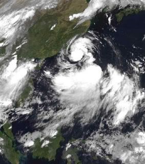
Tropical Storm Dalila
Tropical Storm Dalila was already starting to fade on July 26, 2007, when the QuikSCAT satellite captured this image. The image shows windspeed in color and wind direction with barbs. The white barbs point to areas of intense rain. Dalila was never a big storm and was just declining from its peak when the data used to create this image were captured. High wind speeds—red and purple—are north of the calm region, represented by a green spot, that marks the center of the storm. In a well-organized storm, high winds circle a calm eye like a bull’s eye. Though the wind direction circles the center in neat bands, the storm itself is spread in a horizontal oval instead of a symmetrical circle.
Tropical Storm Dalila was the eighth tropical system to form in the East Pacific during the 2007 season, and the fourth named storm. Dalila formed south of Baja California and arced northwest over cooled waters as it degraded. At the time this image was taken, the storm’s winds blew at 74-83 kilometers per hour (40-45 knots or 46-52 miles per hour) said UNISYS Weather.
05W Is op weg om een categorie 4 te worden.
Als z'n koers iets veranderd gaat ie zo op Tokyo af, als categorie 4.
[ Bericht 15% gewijzigd door #ANONIEM op 28-07-2007 23:40:00 ]
Als z'n koers iets veranderd gaat ie zo op Tokyo af, als categorie 4.

[ Bericht 15% gewijzigd door #ANONIEM op 28-07-2007 23:40:00 ]

T.S. Usagi in Western Pacific
Tropical Storm Usagi has developed in the Western Pacific. The storm is located about 430 miles south-southeast of Iwo To and continues to become better organized. It is expected to strengthen into a typhoon by Monday afternoon (Eastern time) and head in the general direction of Japan bringing rough seas to the East Coast of Japan around the middle of the week. As of 2 am Eastern time, the center of Usagi was located near 18.8 North, 144.8 East. Movement was toward the west around 16 mph. Maximum winds are near 40 mph.
In the Atlantic, a disorganized area of low pressure near the Bahamas continues to move to the north-northeast, and is expected to move into conditions that are more favorable for development over the next few days.
In the Eastern Pacific, a tropical wave about 950 miles south-southwest of Cabo San Lucas (at the southern tip of Baja California) is moving away from the Mexican Coast into the open Pacific and could slowly develop over the next couple of days.
Ziet er mooi uit..... Typhoon Usagi
Tropical Storm Chantal racing northeastward
Tropical Storm Chantal (50 mph) has been christened in the Atlantic and is racing northeastward into open waters. It poses no threat to the U. S. and is expected to become extratropical (non-tropical) tonight before brushing Cape Race, Newfoundland, early tomorrow. The storm probably will end up as part of a large low pressure system near Iceland this weekend.
Another disturbance being monitored in the Atlantic is a tropical wave located about 600 miles east of the Windward Islands. The wave is moving westward at 10 to 15 mph and may be investigated by Air Force Reserve Hurricane Hunters tomorrow. Although convection associated with the disturbance became less organized this morning, the system still has a slight chance of becoming a depression over the next day or so.
In the eastern Pacific, an cluster of thunderstorms centered over 1000 miles southwest of Cabo San Lucas, Mexico, could become a tropical depression over the next day or two as it continues to move westward.
Finally, in the western Pacific, Typhoon Usagi (120 mph) is growing stronger and more dangerous as it swirls northwestward in the Philippine Sea. Usagi is forecast to be very near southern Japan by early Thursday (U. S. time).

The third tropical depression of the Atlantic hurricane season formed around 11:00 p.m. EDT on Monday, July 30 west of Bermuda. Exactly 12 hours later on Tuesday, July 31, at 11:00 a.m. EDT, the storm strengthened into a tropical storm with sustained winds of 40 mph and higher gusts. At that time, the storm was named Tropical Storm Chantal. Chantal was located near latitude 40.2 north and longitude 62.7 west, about 330 miles (530 km) south of Halifax, Nova Scotia and is moving rapidly toward the northeast near 23 mph (37 km/hr). Chantal is not a threat to the United States.
Estimated minimum central pressure is 999 millibars, down from 1007 millibars just five hours before on July 31. A drop in pressure is a sign of strengthening.
Chantal is the cluster of clouds off the U.S. east coast in the top right side of this satellite image. This image was created with data from the Geostationary Operational Environmental Satellite (GOES-12), on July 31 at 14:30 UTC (10:30 a.m. EDT). GOES-12 is operated by the National Oceanic and Atmospheric Administration. This image was created by NASA's GOES Project Science Office at NASA's Goddard Space Flight Center, Greenbelt, Md.
What do the Forecast Models Show?
The National Hurricane Center forecast discussion notes that Chantal is quickly moving into cooler waters, and little additional intensification is expected. Global computer models suggest that Chantal will become the main part of a large powerful low over the northern Atlantic Ocean and a little additional strengthening is shown in a couple days.
Another Atlantic Storm Brewing
Elsewhere, forecasters are eyeing an area of low pressure is centered about 700 miles east of the southern windward islands. This system shows some signs of organization...and it has the potential to become a tropical depression in the next couple of days as it moves westward around 15 mph. Credits: Image - NASA GOES Project/NOAA;Summary - Rob Gutro (derived from NHS reports) Goddard Space Flight Center

Typhoon Usagi
The fourth typhoon of 2007 in the western Pacific, Typhoon Usagi was just southwest of Japan’s Volcano Islands, which include Iwo Jima, on July 31, when the Moderate Resolution Imaging Spectroradiometer (MODIS) flying on NASA’s Aqua satellite captured this image. The storm had become a Category Two storm on the Saffir-Simpson Scale with winds of 167 kilometers per hour (90 knots or 104 miles per hour) and gusts to 200 km/hr (110 knots or 127 mph), according to Unisys Weather. Forecasts from the Joint Typhoon Warning Center predicted that Usagi would strengthen into a Category Four storm and weaken slightly before striking southern Japan on August 2.
The outermost bands of Typhoon Usagi sit over the Volcano Islands in the north and touch the Northern Mariana Islands in the south in this image. Guam is under the outermost fringe in the storm in the lower right corner of the image. Usagi was arcing northeast over the North Pacific, channeling haze ahead of it. The haze casts a dingy white veil on the upper left corner of the image. It probably originated from large wildfires in southeastern Siberia or from industrial pollution in China.
Over 24 gaat Usagi japan treffen met golven van 10 meter hoog en windsnelheden van meer dan 200km/uur. En uiteraard heel veel neerslag.

quote:
Dit kan nog wel wat gaan worden.quote:Eyeing Another Area for Possible Development
Elsewhere, forecasters continue to eye low pressure associated with a tropical wave, located just east of the Windward Islands. While environmental conditions do not appear especially favorable for development, the National Hurricane Center notes that there is still some potential for this system to become a tropical depression during the next day or two as it moves westward near 15 to 20 mph. Storm summary credit: Rob Gutro (derived from NHS reports)/Goddard Space Flight Center
Typhoon Usagi
Typhoon Usagi is forecast to strike Japan at about 08:00 GMT on 2 August. Data supplied by the US Navy and Air Force Joint Typhoon Warning Center suggest that the point of landfall will be near 31.8 N, 132.4 E. Usagi is expected to bring 1-minute maximum sustained winds to the region of around 212 km/h (132 mph). Wind gusts in the area may be considerably higher.
According to the Saffir-Simpson damage scale the potential property damage and flooding from a storm of Usagi's strength (category 4) at landfall includes:
Storm surge generally 4.0-5.5 metres (13-18 feet) above normal.
Curtainwall failures with some complete roof structure failures on small residences.
Shrubs, trees, and all signs are blown down.
Complete destruction of mobile homes.
Extensive damage to doors and windows.
Low-lying escape routes may be cut by rising water 3-5 hours before arrival of the centre of the storm.
Major damage to lower floors of structures near the shore.
Terrain lower than 3 metres (10 feet) above sea level may be flooded requiring massive evacuation of residential areas as far inland as 10 km (6 miles).
There is also the potential for flooding further inland due to heavy rain.
Taifoen Usagi maakt minstens acht doden in Japan
TOKIO 02/08 (BELGA) = Een krachtige wervelstorm is donderdag over het Japanse vasteland getrokken. Met windsnelheden tot 162 kilometer per uur raasde taifoen Usagi over het departement Miyazaki in de in het zuiden gelegen regio Kyushu. Minstens acht mensen raakten gewond. Ruim 200 vluchten en talrijke spoorverbindingen werden afgelast. Bijna tienduizend gezinnen zaten zonder stroom. Twee mannen raakten in Miyazaki gewond toen het dak van een huis afscheurde. De Japanse weerdienst waarschuwde mensen in het bijzonder voor aardverschuivingen. Usagi, de vijfde taifoen van het seizoen, beweegt zich momenteel met een snelheid van 30 kilometer per uur richting noordwesten naar de Japanse Zee. Volgens de berekeningen van meteorologen zou de wervelstorm dan kracht verliezen. Tegen vrijdagmorgen zal volgens de weerdiensten 400 millimeter regen in het zuiden van Japan neerstromen. (HOA)
http://www.knack.be/belga(...)5-article101833.html
Typhoon Usagi hits southern Japan
Usagi is the second major typhoon to hit Japan this season
Eighteen people were injured and thousands sought shelter as Typhoon Usagi struck Japan's southern island of Kyushu.
The typhoon made landfall late on Thursday, bringing winds of up to 180 km/h (110mph).
It cut power to thousands of homes and felled trees. Bullet trains from the main island, Honshu, were suspended.
Usagi is moving northwards, but it has weakened and meteorologists have now downgraded it to a tropical storm.
Television footage showed uprooted trees and flooded rivers. A number of flights were cancelled.
Among the injured was an 81-year-old woman in the southern prefecture of Kagoshima who was blown over and broke her thigh, a local official said.
A postman was injured after wind overturned his van, another official said. Two people were reportedly hurt in falls from roofs.
In the hardest-hit areas, families and the elderly took refuge in municipal shelters.
Usagi, which means rabbit in Japanese, is the second major storm to hit Japan this season.
In July, Typhoon Man-yi left three people dead when it struck Kyushu and neighbouring island Shikoku.
http://news.bbc.co.uk/1/hi/world/asia-pacific/6928931.stm

Typhoon Usagi
Just weeks after taking a beating from Typhoon Man-Yi in mid-July 2007, Japan’s southern islands were visited by Typhoon Usagi in early August. Although not as strong as Man-Yi, Usagi still forced the region to cancel air traffic and ferry services, and it left tens of thousand of homes without power, said news reports.
This image from the Moderate Resolution Imaging Spectroradiometer (MODIS) on NASA’s Terra satellite was captured on August 2, 2007, at 02:10 Universal Coordinated Time (11:10 a.m. local time in Japan). The northwest quadrant of Typhoon Usagi blankets Kyushu, Shikoku, and western Honshu with clouds. The outermost bands of clouds reach South Korea. The eye of the storm was about 55 kilometers (34 miles) off shore of southern Kyushu. Towering thunderstorms along the northern rim of the eye make it seem like the clouds are boiling.
Usagi was the fifth named storm of 2007 in the western Pacific. The storm reached Category 4 status, with maximum sustained winds of 120 knots (222 kilometers per hour, 138 miles per hour), but had weakened to Category 3 status, with winds of 100 knots (185 kilometers per hour, 115 miles per hour) about two hours before this image was captured.
Hallo,
Dit is mijn eerste post in dit forum/topic !
Er is vanacht een nieuwe storm ontstaan in de W.Pacific.
Dit zou weleens een zware storm kunnen worden voor Taiwan & China.
Pabuk is de naam van deze storm.
Dit is mijn eerste post in dit forum/topic !
Er is vanacht een nieuwe storm ontstaan in de W.Pacific.
Dit zou weleens een zware storm kunnen worden voor Taiwan & China.

Pabuk is de naam van deze storm.
Hurricane, Typhoon, Cycloon zijn welkom !
Gaat lekker
Waarom nou nooit eens NL stomme orkanen
Waarom nou nooit eens NL stomme orkanen
<a href="https://www.youtube.com/channel/UCPueUwKfPaGH7v48LZlltkg" rel="nofollow" target="_blank">WSDokkum Youtube</a>
In de E.Pacific & W.Pacific is het seizoen tot nu toe behoorlijk lekker.
Maar in de Atlantische Oceaan is het nog niet veel. Maja hopelijk komt er nog wat vuurwerk.
Maar in de Atlantische Oceaan is het nog niet veel. Maja hopelijk komt er nog wat vuurwerk.
Hurricane, Typhoon, Cycloon zijn welkom !
Tropische storm eist levens in Vietnam (nieuws.nl)
(Novum/AP) - Een tropische storm met windsnelheden tot ruim zeventig kilometer per uur heeft in Vietnam negen slachtoffers geëist. Acht van hen verdronken door plotselinge overstromingen en een werd door een omvallende boom getroffen. Dat hebben de Vietnamese autoriteiten maandag gemeld.
Veertien mensen werden nog vermist. Tot de vermisten horen ook vijf leden van een familie, wier huis werd weggeslagen door een door de hevige regen aangezwollen rivier. In de provincie Daklak viel in vier dagen tijd 62 centimeter regen. Voor de komende dagen is nog meer regen voorspeld.
AUGUST BEGINS FAIRLY QUIET
The Atlantic Basin is still quiet as we make our way through the early part of August. There are a few tropical waves dotting the map but none look like they will develop over the next few days. Even though it is August, we really don't expect to see that dramatic upswing in activity until after the 15th. Between now and then, we might see a little activity pop up but it really is latter August, all of September and a good deal of October that we have to pay the most attention to. For most of you, this is nothing new. You know this. For those wondering where the hurricane season is- just wait a couple of more weeks and I believe we will see a marked increase in tropical storms. Who knows? Maybe we'll be fortunate enough to have very little to deal with again this season. There is no way to tell for sure, just be ready. I will have more here on Monday when I talk about our two newest sponsors of the site- and of course any goings on in the tropics. This weekend will be nice and quiet. (hurricanetrack)
The Atlantic Basin is still quiet as we make our way through the early part of August. There are a few tropical waves dotting the map but none look like they will develop over the next few days. Even though it is August, we really don't expect to see that dramatic upswing in activity until after the 15th. Between now and then, we might see a little activity pop up but it really is latter August, all of September and a good deal of October that we have to pay the most attention to. For most of you, this is nothing new. You know this. For those wondering where the hurricane season is- just wait a couple of more weeks and I believe we will see a marked increase in tropical storms. Who knows? Maybe we'll be fortunate enough to have very little to deal with again this season. There is no way to tell for sure, just be ready. I will have more here on Monday when I talk about our two newest sponsors of the site- and of course any goings on in the tropics. This weekend will be nice and quiet. (hurricanetrack)
yep, volgens de voorspellingen gaat Pabuk Taipei recht raken.... Heb inmiddels een storm waarschuwing per email doorgekregen. Momenteel is er een Red Alert warning voor Taipei = Red Alert (Severe) is CAT 1 or above to between 31% and 100% probability.
Volgens de lokale weerbureau is er momenteel een 45% kans op een Cat1+ hit in Taipei, en een 65% op een TS.
es kijken of ik vrij kan krijgen
Volgens de lokale weerbureau is er momenteel een 45% kans op een Cat1+ hit in Taipei, en een 65% op een TS.
es kijken of ik vrij kan krijgen
Totaal Travel 04-24: 87 reizen, 151 vliegtickets, 58 landen, 6 continenten, 949 reisdagen, 163.804 foto's
Mijn reisfotos!
Mijn reisfotos!
Taiwan word zo goed als zeker geraakt door Pabuk, de vraag is of het nog officieel gaat uitgroeien tot een typhoon. Momenteel is het nog een tropische storm. Verwachting is dat deze net groeit tot een typhoon als hij aan land gaat.
Pabuk is gedurende de nacht iets naar het zuiden gedraaid waardoor Taipei waarschijnlijk gemist gaat worden. Kans blijft aanwezig dat Taipei nog een flinke opzwieper krijgt, TSR schat 35% op typhoon kracht winden in Taipei, en 80% kans op tropische storm wind.
Regen is inmiddels losgebarsten nu de storm dichtbij is....
Over een uur de volgende update. Nog ~24 uur voordat de storm Taiwan gaat bereiken.......
Pabuk is gedurende de nacht iets naar het zuiden gedraaid waardoor Taipei waarschijnlijk gemist gaat worden. Kans blijft aanwezig dat Taipei nog een flinke opzwieper krijgt, TSR schat 35% op typhoon kracht winden in Taipei, en 80% kans op tropische storm wind.
Regen is inmiddels losgebarsten nu de storm dichtbij is....

Over een uur de volgende update. Nog ~24 uur voordat de storm Taiwan gaat bereiken.......
Totaal Travel 04-24: 87 reizen, 151 vliegtickets, 58 landen, 6 continenten, 949 reisdagen, 163.804 foto's
Mijn reisfotos!
Mijn reisfotos!
Black swans matter
Hoewel dit volgens mij een typhoon wordt voor mietjuhs heb ik toch mijn fietstocht door de bergen van Taiwan nog even een paar dagen uitgesteld. Ik wou eigenlijk morgen vetrekken.
"If you want to make God laugh, tell him about your plans"
Mijn reisverslagen
Mijn reisverslagen
Tropical storm threatens Taiwan
regenkaart Tropical Depression 06W
In Vietnam valt de komende uren nog veel regenquote:No tropical development is expected in the Atlantic Basin over the next day or two.
In the eastern Pacific, an area of low pressure contains some limited convection over 875 miles southwest of Cabo San Lucas, Mexico. The system may slowly develop but is no threat to land.
Tropical Storm Pabuk (65 mph), currently located several hundred miles ESE of Taiwan. The storm is moving toward the WNW and is forecast to intensify to typhoon strength before striking Taiwan late Tuesday (U. S. time). Heavy rain and strong winds are likely in Taiwan as Pabuk sweeps in. Flooding rain may be a major problem. After crossing the island, Pabuk should weaken to a tropical storm and punch into mainland China on Wednesay (U. S. time).
A weak tropical depression is producing heavy rain over northern Vietnam and Laos.
regenkaart Tropical Depression 06W
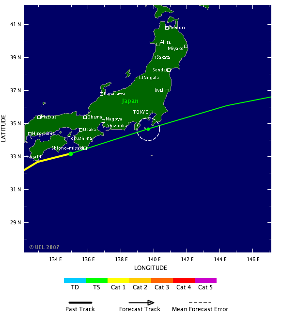
Koers Typhoon PABUK voor 24 uur. Nu een categorie 1.
[ Bericht 7% gewijzigd door #ANONIEM op 07-08-2007 08:55:12 ]

[ Bericht 7% gewijzigd door #ANONIEM op 07-08-2007 08:55:12 ]

Black swans matter
Nou het stelt voorlopig niks voor die typhoon.
Hier (Taipei) alleen een beetje motregen en nauwelijks wind.
Ik has net zo goed kunnen gaan fietsen.
Hier (Taipei) alleen een beetje motregen en nauwelijks wind.
Ik has net zo goed kunnen gaan fietsen.


"If you want to make God laugh, tell him about your plans"
Mijn reisverslagen
Mijn reisverslagen

weinig wind, weet je zeker dat je niet in het oog zit?quote:Op dinsdag 7 augustus 2007 10:30 schreef SeLang het volgende:
Nou het stelt voorlopig niks voor die typhoon.
Hier (Taipei) alleen een beetje motregen en nauwelijks wind.
Ik has net zo goed kunnen gaan fietsen.
[afbeelding]
[afbeelding]
[b]Op maandag 6 september 2010 00:28 schreef tong80 het volgende:[/b]
GVD Wat moet jij een trotse vader zijn :)
:P
GVD Wat moet jij een trotse vader zijn :)
:P
Black swans matter
Dat heb ik serieus een keer meegemaakt een paar jaar geleden. Dat was echt weird; eerst waait het heel hard de ene kant op, dan is het een uurtje ofzo bijna windstil en daarna waait het keihard de andere kant op.quote:Op dinsdag 7 augustus 2007 10:37 schreef Againzender het volgende:
[..]
weinig wind, weet je zeker dat je niet in het oog zit?
"If you want to make God laugh, tell him about your plans"
Mijn reisverslagen
Mijn reisverslagen
Black swans matter
Denk je dat je het hebt gehad, komt er nog een typhoon aan

"If you want to make God laugh, tell him about your plans"
Mijn reisverslagen
Mijn reisverslagen
Kan ik naar je toe komen, laat het gelijk een goeie zijn dan
<a href="https://www.youtube.com/channel/UCPueUwKfPaGH7v48LZlltkg" rel="nofollow" target="_blank">WSDokkum Youtube</a>
kreeg idd weer een waarschuwingsmailtje van TSR, maar dit is een "kleintje" en volgens verwachtingen blijft het een tropische storm. Maar deze gaat wel recht over Taiwan. We zien welquote:Op woensdag 8 augustus 2007 07:21 schreef SeLang het volgende:
Denk je dat je het hebt gehad, komt er nog een typhoon aan
[afbeelding]
Van Pabuk weinig gemerkt behalve een flinke dosis regen, volgende keer beter
Totaal Travel 04-24: 87 reizen, 151 vliegtickets, 58 landen, 6 continenten, 949 reisdagen, 163.804 foto's
Mijn reisfotos!
Mijn reisfotos!
Doden door Tropische Stormen
Vietnam en de Filipijnen worden geteisterd door tropische stormen. In Vietnam zijn minstens 29 mensen om het leven gekomen door de hevigste storm van dit jaar tot dusver, meldden de autoriteiten woensdag.
Zij kwamen om door verdrinking als gevolg van plotselinge overstromingen of door bliksem. Verwacht wordt dat het dodental zal stijgen omdat twaalf mensen nog vermist worden en het nog steeds regent.
Op de Filipijnen veroorzaakte de tropische storm Pabuk aardverschuivingen die aan elf mensen het leven kostten. In het zuidelijk gelegen goudmijnstadje Maco werden maandag tien mensen onder het puin bedolven. Woensdagmorgen veroorzaakte Pabuk, samen met een nieuwe storm die ten noordoosten van de Filipijnen boven zee opstak, hevige regenval in het bergachtige noorden. Een 9-jarige jongen kwam daar eveneens bij een aardverschuiving om. Pabuk raasde later woensdag over de zuidelijke punt van Taiwan, waardoor drieduizend huishoudens zonder stroom kwamen te zitten.
http://www.nieuws.nl/473798
Pabuk made landfall on Tuesday as a minimial typhoon along the southern coast of Taiwan. It is now headed to mainland China near Hong Kong late tonight or early Wednesday (Eastern time). Pabuk is expected to continue to weaken.
Behind Pabuk is newly formed Tropical Storm Wutip. Wutip is headed near the same general path that Pabuk took ahead if it, towards the southern end of Taiwan and then onto mainland China. Wutip is currently not expected to become a typhoon.
In the Eastern Pacific, two clusters of storms--one roughly 1100 miles southwest of Cabo San Lucas, Mexico, the other near the coast of Puerto Vallarta, Mexico--have a slim chance to develop over the next few days.
The Atlantic basin remains quiet.
MORE MODELS SHOWING POTENTIAL DEVELOPMENT OFF OF AFRICA
I wrote earlier today about the GFS computer model and its insistence that we would see a tropical cyclone develop out near Africa in the coming days. Well, we can add the UKMET model from England (it too is a global model) and the Canadian model, though that model often develops storms that never develop. What I am looking for here is a trend and a concensus among more than just one model. That is starting to fall in to place and it will be interesting to see what indeed happens as we approach the weekend. In the longer term, my point of bringing this up is to make you aware that the most active part of the season may be just about to begin. I have heard a lot of talk about it being a quiet season and that it will be that way for the remainder. Well, we can only hope that's the case but the reality is likely to be different than what we hope. I believe we are about to see an increase in development potential and the next several weeks could be quite busy. As the cliche' goes "time will tell". I'll post another update tonight.
I wrote earlier today about the GFS computer model and its insistence that we would see a tropical cyclone develop out near Africa in the coming days. Well, we can add the UKMET model from England (it too is a global model) and the Canadian model, though that model often develops storms that never develop. What I am looking for here is a trend and a concensus among more than just one model. That is starting to fall in to place and it will be interesting to see what indeed happens as we approach the weekend. In the longer term, my point of bringing this up is to make you aware that the most active part of the season may be just about to begin. I have heard a lot of talk about it being a quiet season and that it will be that way for the remainder. Well, we can only hope that's the case but the reality is likely to be different than what we hope. I believe we are about to see an increase in development potential and the next several weeks could be quite busy. As the cliche' goes "time will tell". I'll post another update tonight.
Dodental tropische storm Vietnam loopt verder op
(Novum/AP) - Het dodental ten gevolge van een tropische storm die eerder deze week toesloeg in Centraal-Vietnam is tot zestig opgelopen. Negen mensen worden nog vermist. Aangenomen word dat ook zij zijn omgekomen. Meer dan honderdduizend mensen zijn dakloos geraakt. Dit hebben de autoriteiten vrijdag bekendgemaakt.
Het ging om de hevigste storm van dit jaar. De storm ging gepaard met overstromingen. De provincie Ha Tingh werd het zwaarst getroffen. Daar vielen 22 doden, onder wie acht kinderen.
http://www.nieuws.nl/474107
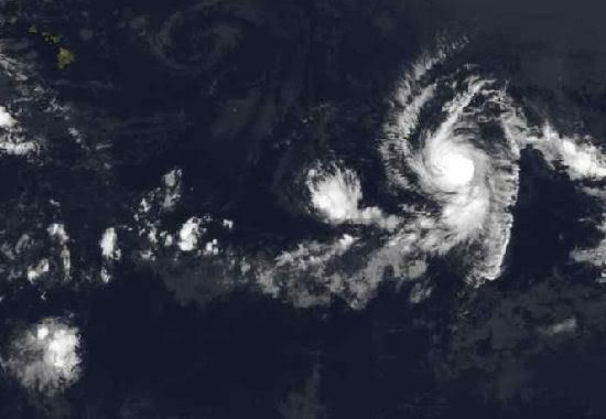
Orkaan Flossie zit nu op een categorie 3 en trekt in de richting van Hawaii.
On August 10, by 11:00 a.m. EDT, Tropical Storm Flossie strengthened into a hurricane in the eastern Pacific Ocean. Hurricane Flossie was headed west toward the big island of Hawaii.
Forecasters noted that satellite imagery indicated that Flossie was strengthening as an eye (center) became more apparent in infrared imagery from the Geostationary Operational Environmental Satellite (GOES). Flossie is located in the lower center of this image, which was taken August 10 at 10:52 a.m. EDT (7:52 a.m. PDT). Looking closely, there is a small dark spot in the middle of Flossie. That dark spot is the eye of the hurricane. The image was created by NASA's GOES Project Science Office at NASA's Goddard Space Flight Center, Greenbelt, Md.
On Friday, August 10 at 15:00 UTC (11:00 a.m. EDT), Flossie was located near 12.7 degrees north latitude and 136.0 west longitude. She was moving west at 12 knots (14 mph) and had a minimum central pressure of 987 millibars. Flossie was a Category 1 hurricane and was packing maximum sustained winds of 65 knots (74 mph) with gusts to 85 knots (97 mph).
The National Hurricane Center noted that slight strengthening is expected during the next 24 hours while Flossie remains over sea surface temperatures greater than 80 degrees Fahrenheit (F). Warm waters of around 80F are needed to continue to power and strengthen hurricanes.
Because sea surface temperatures along the westward forecast track cool, Flossie is expected to gradually weaken beyond 36 to 48 hours. That's good news, because Flossie is expected to pass to the south of the big island Tuesday night, August 14th. She is expected to bring rain and winds to the island as she passes. Image Credit: NOAA/NASA GOES Project; Storm summary: Rob Gutro (derived from NHS reports) Goddard Space Flight Center
We constantly talk about the numbers of tropical storms and hurricanes that form in the Atlantic Basin through the course of hurricane season (June-November).
But perhaps we should look at a statistic that applies more directly to those of us living in the United States, namely U.S. hurricane landfall statistics. After all, you probably care far less about a hurricane that turns into the open north Atlantic than you do about one that is threatening or making landfall on your coastline.
The chart below slows the number of U.S. hurricane landfalls per month since around the start of the satellite era (1965). It clearly indicates that most hurricanes (about 70% of them) hit the U.S. in August and September. October hits equal those of June and July combined.
Of particular interest is the fact that formation of Atlantic Basin tropical storms and hurricanes increases through August, peaks near September 10, then generally falls through the remainder of the season. Late August is historically much more active than early August across "the basin."
But if you count the number of U.S. hurricane landfalls the first 16 versus the last 15 days of August (since 1965) you will find that eight hurricanes hit in the first half of the month and nine, nearly the same number, hit in the second half of the month. This would indicate that a U.S. hurricane strike is nearly as likely in the first half as the second half of August based on this very reliable record.
So when we talk about the season "ramping up" through August, we are talking about the Atlantic Basin as a whole. Just remember for the U.S. coastline there is almost no "ramp up" in hurricane landfalls from the first to second half of August based on the most reliable hurricane record that includes the era of satellites.
bron:
But perhaps we should look at a statistic that applies more directly to those of us living in the United States, namely U.S. hurricane landfall statistics. After all, you probably care far less about a hurricane that turns into the open north Atlantic than you do about one that is threatening or making landfall on your coastline.
The chart below slows the number of U.S. hurricane landfalls per month since around the start of the satellite era (1965). It clearly indicates that most hurricanes (about 70% of them) hit the U.S. in August and September. October hits equal those of June and July combined.
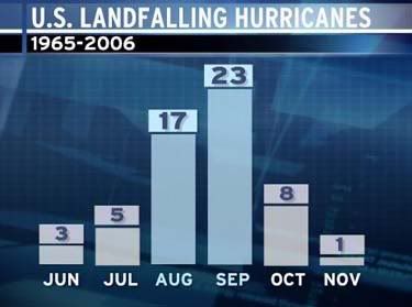
Of particular interest is the fact that formation of Atlantic Basin tropical storms and hurricanes increases through August, peaks near September 10, then generally falls through the remainder of the season. Late August is historically much more active than early August across "the basin."
But if you count the number of U.S. hurricane landfalls the first 16 versus the last 15 days of August (since 1965) you will find that eight hurricanes hit in the first half of the month and nine, nearly the same number, hit in the second half of the month. This would indicate that a U.S. hurricane strike is nearly as likely in the first half as the second half of August based on this very reliable record.
So when we talk about the season "ramping up" through August, we are talking about the Atlantic Basin as a whole. Just remember for the U.S. coastline there is almost no "ramp up" in hurricane landfalls from the first to second half of August based on the most reliable hurricane record that includes the era of satellites.
bron:
NOAA verwacht bovengemiddeld orkaanseizoen
Orkaandeskundigen van NOAA gaan nog steeds uit van een bovengemiddeld orkaanseizoen boven de Atlantische Oceaan. Een eerdere verwachting uit mei is vrijwel gelijk gebleven.
Nog steeds worden 13 tot 16 stormen verwacht, waaruit 3 tot 5 zware orkanen zullen ontstaan. De voorspellers zeggen dat de omstandigheden die waren verwacht, zijn uitgekomen. Het is alleen nu wachten op de eerste krachtige orkanen in het zeegebied.
Dat het nu rustig is op de Atlantische Oceaan is schijn. Tot nog toe zijn er van de 13 tot 16 systemen al drie ontstaan. Volgens de orkaandeskundigen is dat iets boven het gemiddelde. De orkaanactiviteit zal de komende weken sterk toenemen en pieken rond 10 september.
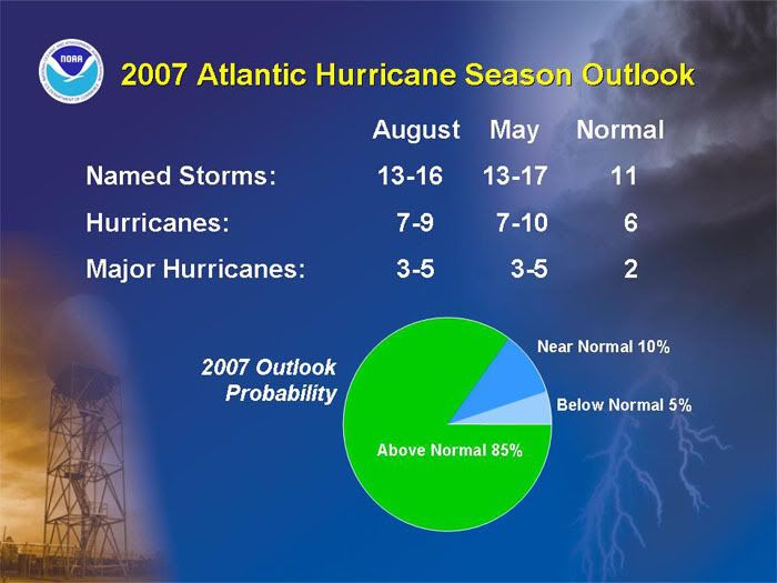
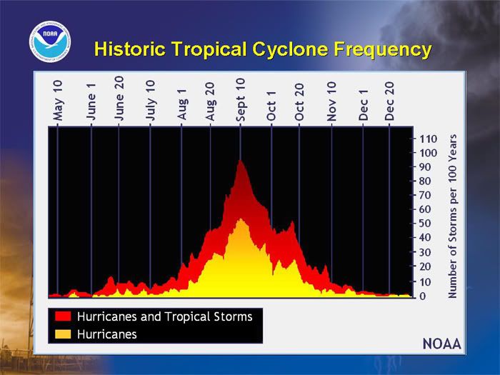
Ik verwacht daar niet veel van. Volgens mij wordt het voor de Atlantic zo'n seizoen als vorig jaar. De Pacific lijkt nu al wel druk.
Het is nog vroeg, maar Tropische Storm Sepat voorspellingen wijzen dat het een grote gaat worden. Voorlopig zal deze groeien tot een cat3 storm, ruim voordat Taiwan wordt bereikt. Voorspelling gaat niet verder in de toekomst, maar meeste typhoons groeien naar mate ze dichter bij land komen. Maar het is nog zeer vroeg, de storm zal Taiwan op zn vroegst over 5 dagen bereiken.quote:
(dat zou kut zijn omdat het dan net mn laatste weekend is in Taiwan )
Totaal Travel 04-24: 87 reizen, 151 vliegtickets, 58 landen, 6 continenten, 949 reisdagen, 163.804 foto's
Mijn reisfotos!
Mijn reisfotos!
Tropical Depression FOUR
Dit lijkt een flinke te worden. Verwachtingen gaan richting 90 KTS als windsnelheid, dat is 166km/h, met stoten tot 110 KTS, 203km/h.
Huidige positie; 800km ten zuidwesten van de Kaapverdische eilanden.
Bestemming: Zuidelijke Caribbean.
Dit lijkt een flinke te worden. Verwachtingen gaan richting 90 KTS als windsnelheid, dat is 166km/h, met stoten tot 110 KTS, 203km/h.
Huidige positie; 800km ten zuidwesten van de Kaapverdische eilanden.
Bestemming: Zuidelijke Caribbean.
/ ¦ ¦ / ¦ ¦
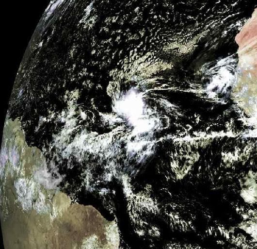
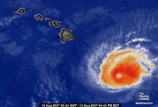
quote:Flossie A Strong Category 3 Storm
By AccuWeather.com Meteorologists Rob Miller and Alex Sosnowski Hurricane Flossie has weakened slightly to a Category 3 storm, with sustained winds of 125 mph . As of 11 a.m. HST Monday, the storm was around 425 miles southeast of Hilo, Hawaii. Hurricane Flossie was located near 15.3 north and 150.6 west and was moving to the west-northwest at 15 mph. The pressure of Flossie is 956 mb or 28.23 inches of mercury. Flossie is a relatively small storm with hurricane-force winds extending about 40 miles from the center and tropical storm-force winds extending 100 miles from the center. Flossie will likely slowly weaken during the balance of Monday and Tuesdayas it starts to encounter some cooler waters as it nears the Hawaiian Islands. The track of the storm has Flossie passing just south of the the Islands late Monday night into Tuesday. This will potentially bring heavy rainfall and gusty winds to the eastern and southern parts of the islands, as well as very rough surf. All interests in Hawaii should keep an eye on this storm as it continues to near the state. Elsewhere in the eastern Pacific Basin, a tropical wave is found near 98 west, mostly south of 17 north. This wave is moving westward at 15 knots. Another wave at 90 west is also moving westward at 15 knots. Satellite images Monday morning show several clusters of strong thunderstorms near these waves, but they remain disorganized at this time. Another tropical wave is found near 107 west and has an embedded 1012 mb (29.88 inches of mercury) low within this wave. This feature is moving west at 10-15 knots. While low pressure is present, this feature remains disorganized at this time. A final wave is found along 129 west, moving westward at 15 knots. Little to no convection is found with this wave.
Flossie Weakened, passes Hawaiian Islands
HONOLULU — Hurricane Flossie weakened to a Category 3 storm Monday with maximum sustained winds of 126 mph as it roared toward Hawaii, but it was expected to pass by the islands.
Forecasters earlier had said cooler weather would weaken the storm to a Category 1 hurricane, with sustained wind of at least 74 mph, by the time it passes about 70 miles south of the Big Island of Hawaii late Tuesday or early Wednesday.
But on Monday forecasters said they now expected a Category 3 hurricane, with little change in strength when it passes the island. Earlier in the day, Flossie had been a Category 4 storm with maximum sustained winds of 140 mph.
"The intensity has remained stronger than what was originally forecast, but the track has been pretty much right on," said Jim Weyman, the National Weather Service's meteorologist in charge in Honolulu.
The Central Pacific Hurricane Center said Flossie "remains a dangerous hurricane with a clear well-defined eye and good outflow. ... It must be noted that Flossie has been surprisingly resilient to cooler ocean temperatures so far."
Hurricane Off Hawaii Coast Upgraded to Category 4 The weather service placed the Big Island under a hurricane watch and a tropical storm warning. A flash flood watch was also issued for the island through Wednesday, with possible flash flooding in areas.
Mayor Harry Kim declared a state of emergency Monday as a precaution. All 56 public school on the Big Island also were closed for Tuesday.
The Big Island is largely rural, with about 150,000 people, and most live in the west or northeast, not the southern portion expected to be hit hardest by the hurricane. Other islands are expected to get much less of the storm's wind and rain.
At 5 p.m. EDT, Flossie was about 425 miles southeast of Hilo, the Central Pacific Hurricane Center said. It was moving west-northwest at about 15 mph.
Meteorologists cautioned that even a slight change of course in the unpredictable storm could take it closer to land.
Emergency workers had mobilized Sunday afternoon to prepare for the potentially devastating hurricane, the mayor said.
"You always prepare for the worst case scenario and hope for the best," Kim said.
Even though the eye of the storm may miss the Hawaiian Islands, Flossie could still bring strong wind and heavy rain, forecasters said.
Officials strongly urged residents statewide to prepare, including having a supply of food, water and disaster plans.
"If Flossie misses us, that's great. But we're still in hurricane season," said Ray Lovell, spokesman for the state Civil Defense Agency.
Parts of the Big Island, home to one of the world's most active volcanoes in Kilauea, likely will experience tropical storm-level winds and at least 10 to 15 inches of rain, Weyman said.
The south shore could see also see waves of 10 to 15 feet, forecasters said, with the surf rising starting late Monday. Waves along the east facing shores could increase to 8 to 12 feet on Tuesday. The island's South Point is the southernmost area of the United States.
The last time a hurricane hit Hawaii was in 1992, when Iniki ravaged Kauai, killing six people and causing $2.5 billion in damage.
Hurricane season runs from June 1 to Nov. 30. In May, forecasters said the Hawaiian Islands and the rest of the central Pacific faced a slightly below-average hurricane season, with just two or three tropical cyclones expected because of lower sea surface temperatures.
The islands get an average of 4.5 tropical cyclones a year; only about one every 15 years is powerful enough to be a hurricane. Last year, the central Pacific had five tropical cyclones after the National Oceanic and Atmospheric Administration predicted two to three.
On July 21, a tropical depression moved past the Big Island, bringing a few inches of rain to the parched island but no major problems. Cosme, the year's first Pacific tropical cyclone, reached hurricane status for a day before it weakened. (Foxnews)
FLOSSIE
[ Bericht 1% gewijzigd door Frutsel op 14-08-2007 10:34:11 ]
HONOLULU — Hurricane Flossie weakened to a Category 3 storm Monday with maximum sustained winds of 126 mph as it roared toward Hawaii, but it was expected to pass by the islands.
Forecasters earlier had said cooler weather would weaken the storm to a Category 1 hurricane, with sustained wind of at least 74 mph, by the time it passes about 70 miles south of the Big Island of Hawaii late Tuesday or early Wednesday.
But on Monday forecasters said they now expected a Category 3 hurricane, with little change in strength when it passes the island. Earlier in the day, Flossie had been a Category 4 storm with maximum sustained winds of 140 mph.
"The intensity has remained stronger than what was originally forecast, but the track has been pretty much right on," said Jim Weyman, the National Weather Service's meteorologist in charge in Honolulu.
The Central Pacific Hurricane Center said Flossie "remains a dangerous hurricane with a clear well-defined eye and good outflow. ... It must be noted that Flossie has been surprisingly resilient to cooler ocean temperatures so far."
Hurricane Off Hawaii Coast Upgraded to Category 4 The weather service placed the Big Island under a hurricane watch and a tropical storm warning. A flash flood watch was also issued for the island through Wednesday, with possible flash flooding in areas.
Mayor Harry Kim declared a state of emergency Monday as a precaution. All 56 public school on the Big Island also were closed for Tuesday.
The Big Island is largely rural, with about 150,000 people, and most live in the west or northeast, not the southern portion expected to be hit hardest by the hurricane. Other islands are expected to get much less of the storm's wind and rain.
At 5 p.m. EDT, Flossie was about 425 miles southeast of Hilo, the Central Pacific Hurricane Center said. It was moving west-northwest at about 15 mph.
Meteorologists cautioned that even a slight change of course in the unpredictable storm could take it closer to land.
Emergency workers had mobilized Sunday afternoon to prepare for the potentially devastating hurricane, the mayor said.
"You always prepare for the worst case scenario and hope for the best," Kim said.
Even though the eye of the storm may miss the Hawaiian Islands, Flossie could still bring strong wind and heavy rain, forecasters said.
Officials strongly urged residents statewide to prepare, including having a supply of food, water and disaster plans.
"If Flossie misses us, that's great. But we're still in hurricane season," said Ray Lovell, spokesman for the state Civil Defense Agency.
Parts of the Big Island, home to one of the world's most active volcanoes in Kilauea, likely will experience tropical storm-level winds and at least 10 to 15 inches of rain, Weyman said.
The south shore could see also see waves of 10 to 15 feet, forecasters said, with the surf rising starting late Monday. Waves along the east facing shores could increase to 8 to 12 feet on Tuesday. The island's South Point is the southernmost area of the United States.
The last time a hurricane hit Hawaii was in 1992, when Iniki ravaged Kauai, killing six people and causing $2.5 billion in damage.
Hurricane season runs from June 1 to Nov. 30. In May, forecasters said the Hawaiian Islands and the rest of the central Pacific faced a slightly below-average hurricane season, with just two or three tropical cyclones expected because of lower sea surface temperatures.
The islands get an average of 4.5 tropical cyclones a year; only about one every 15 years is powerful enough to be a hurricane. Last year, the central Pacific had five tropical cyclones after the National Oceanic and Atmospheric Administration predicted two to three.
On July 21, a tropical depression moved past the Big Island, bringing a few inches of rain to the parched island but no major problems. Cosme, the year's first Pacific tropical cyclone, reached hurricane status for a day before it weakened. (Foxnews)
FLOSSIE

[ Bericht 1% gewijzigd door Frutsel op 14-08-2007 10:34:11 ]
kwestie van tijd voor TD 4 DEAN zal worden....
MIAMI, Florida (AP) -- A tropical depression formed Monday in the far eastern Atlantic, the fourth of the Atlantic hurricane season, meteorologists said.
At 5 p.m. EDT, the depression was centered about 620 miles west-southwest of the southernmost Cape Verde Islands, and moving west near 20 mph, according to the National Hurricane Center. It was still about 1,900 miles east of the Lesser Antilles in the Caribbean.
Its maximum sustained wind speed was about 35 mph, forecasters said. It would be named Tropical Storm Dean if its sustained wind strengthens to at least 39 mph, the threshold for a named storm.
Hurricane forecasters expect this year's hurricane season to be busier than average. Last week, they said up to 16 tropical storms are likely to form, with nine of them becoming hurricanes.
The Atlantic hurricane season runs from June 1 to November 30, but August typically marks the start of the most active period. Last year, there were 10 tropical storms in the Atlantic and just two made landfall in the United States.
[ Bericht 55% gewijzigd door Frutsel op 14-08-2007 10:29:20 ]

misschien komt ie wel nergens aan land, dat ie zo verder naar het noorden met een boogje de oceaan op gaat.
verder nog een stormpje in de Golf van Mexico die op die grens Mexico/USA aan land komt.
Dostojewski: "Je kunt je niet van je eigen gezond verstand overtuigen door je buurman op te sluiten."
waarschuwings briefjes hangen alweer in de lobby, kans is kleind at ie hit, maar het belooft een flinke te worden.quote:Op dinsdag 14 augustus 2007 10:12 schreef Frutsel het volgende:
Sepan
[afbeelding]
Idd...mogelijk weer Taiwan
Totaal Travel 04-24: 87 reizen, 151 vliegtickets, 58 landen, 6 continenten, 949 reisdagen, 163.804 foto's
Mijn reisfotos!
Mijn reisfotos!
kan natuurlijk ook zijn dat ze die in de Golf van Mexico Dean noemen en die andere Erin.
want ze komen ongeveer tegelijkertijd op tropical storm-sterkte.
want ze komen ongeveer tegelijkertijd op tropical storm-sterkte.
Dostojewski: "Je kunt je niet van je eigen gezond verstand overtuigen door je buurman op te sluiten."
verrekquote:Op dinsdag 14 augustus 2007 10:18 schreef Caesu het volgende:
kan natuurlijk ook zijn dat ze die in de Golf van Mexico Dean noemen en die andere Erin.
want ze komen ongeveer tegelijkertijd op tropical storm-sterkte.
daar zit er ook eentje inderdaad
via Hurricanetrack.com
quote:UPDATED: 10:45 am EDT, August 14, 2007
NHC UPGRADES TD#4 TO TS DEAN
Just a quick note to update the fact that TD 4 is now TS Dean. The NHC made the upgrade just a little while ago. Forecast shows Dean becoming a strong hurricane as it passes through the NE Caribbean Sea in about five days. I have updated the tracking maps and will have a full update here later this afternoon, around 5pm ET.
UPDATED: 8:50 am EDT, August 14, 2007
GULF, ATLANTIC AND PACIFIC VERY ACTIVE THIS WEEK
There is now plenty of activity from the central Pacific to the Gulf of Mexico and out in to the east Atlantic. The quiet hurricane season we were enjoying has come to an abrupt end and this is really just the start.
Hurricane Flossie is weakening as it approaches Hawaii but the one time category four hurriane will still bring squally weather and rough seas. The forecast keeps Flossie just south of the string of islands so we don't expect too much of an impact. It could certainly be worse and we saw that back in 1992 when powerful hurricane Iniki lashed portions of the islands. This time around, it is just a close call and that is good news for anyone who lives in or is planning a trip to Hawaii.
Next up is our developing tropical depression in the Gulf of Mexico. Upper level winds are more favorable and it is quite possible that the NHC will upgrade the system to a depression later today. Most computer models develop this in to a tropical storm and move it towards Mexico and Texas. The biggest threat will be heavy rains but if it intensifies quickly enough, there could also be some wind and surge issues as well. The NHC is sending a Hurricane Hunter plane in to the area later today, if conditions continue to warrant, and we will know a lot more at that point.
Out in the east Atlantic is TD #4. It is holding its own and is in no hurry to strengthen right away. It is in a hurry in a literal sense though. The depression is moving very quickly towards the west at over 20 mph. The NHC forecasts the depression to become a tropical storm and then a hurricane as it nears the northern Leeward Islands. This could be quite an interesting situation for folks in the northeast Caribbean Sea as some computer models show the (at that point) hurricane passing through the islands while others miss to the north. It looks like what ever scenario that plays out will do so within about five days- so there is still time to just wait and see what happens. Beyond five days, we get little solid evidence of what the system will do. The key will be, as always, how strong the cyclone is and what the steering currents are like to its north. There is no need to even try to speculate this early as to where this might end up. We have a long, long time to watch and track its progress, which gives a great advantage of allowing us to be prepared, if need be. The rest of the tropics are mostly quiet but we are now in a period when we will likely see a new named storm on a regular basis somewhere in the Atlantic Basin. I will post another update here early this afternoon and again this evening.
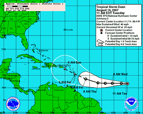
* I intend to live forever, so far so good! *
Orkaan dreigt bij Antillen
AMSTERDAM - Metereologen vrezen dat tropische storm Dean zich richting de Antillen kan ontwikkelen tot de eerste orkaan van het seizoen. Ook bij Hawaii is groot alarm geslagen vanwege orkaan Flossie.
Waar Dean schade gaat aanrichten, is volgens CNN vooralsnog onduidelijk. Orkanen volgen vaak een onnavolgbaar spoor van vernieling. De laatste kaarten wijzen erop dat het centrum kan liggen bij de Dominicaanse republiek. De Nederlandse Antillen zouden volgens die zelfde voorspellingen aan de rand van de gevarenzone liggen
.De tropische storm volgt z'n weg richting de kust van Venezuela. Het slechte weer gaat met een snelheid van ruim dertig kilometer per uur naar de eilandengroep, zo meldt het National Hurricane Center in Miami. Voorlopig is de storm nog 1500 mijl verwijderd van de Antillen. De windsnelheid kan op gaan lopen naar 96 mijl per uur komend weekend. De storm kan zich verder ontwikkelen als het slecht weer gebied over warm water gaat.
Aan de andere kant van Amerika bij Hawaii zijn veel maatregelen genomen tegen de komende orkaan Flossie. De noodtoestand is uitgeroepen en windsnelheden zullen ook tot zo'n 150 kilometer per uur kunnen oplopen. De beroemde surfgolven zullen huizenhoog worden.
Orkaandeskundigen voorspellen dit jaar het drukste Hurricane-seizoen ooit op de Atlantische oceaan. Ze verwachten zestien tropische stormen, waarvan zich waarschijnlijk negen zullen ontwikkelen tot orkaankracht.
Het 'seizoen' loopt meestal van begin juni tot eind november, maar augustus begint het gerommel vaak pas goed.
De Telegraaf
Dean wordt telkens weer wat zuidelijker voorspeld.
hij gaat iig over de Bovenwindse Eilanden nu en daarna over Hispaniola en Cuba of Jamaica.
daarna kan ie nog altijd in Mexico of Amerika aan land komen.
of hij gaat nog verder zuidelijker vlak boven de ABC-eilanden zo naar Honduras/Belize/Yucatan.
hij gaat iig over de Bovenwindse Eilanden nu en daarna over Hispaniola en Cuba of Jamaica.
daarna kan ie nog altijd in Mexico of Amerika aan land komen.
of hij gaat nog verder zuidelijker vlak boven de ABC-eilanden zo naar Honduras/Belize/Yucatan.
Dostojewski: "Je kunt je niet van je eigen gezond verstand overtuigen door je buurman op te sluiten."
Sepat update: Momenteel uitgegroeid tot een categorie 4 typhoon, voorspelling is dat deze over 24 uitgroeid tot een Supertyphoon, een categorie 5!!!!!!!! Max windsnelheid verwacht van 145 knots....
Er is een grote kans dat het zuiden van Taiwan wordt geraakt, waar het nu al last heeft van veel regen en overstromingen. Met deze storm erbij voorspelt het weinig goeds. Taipei lijkt voorlopig veilig te zijn, maar stormen hebben de vervelende eigenschap de voorspellingen niet altijd te volgen.
prachtige oog te zien
Er is een grote kans dat het zuiden van Taiwan wordt geraakt, waar het nu al last heeft van veel regen en overstromingen. Met deze storm erbij voorspelt het weinig goeds. Taipei lijkt voorlopig veilig te zijn, maar stormen hebben de vervelende eigenschap de voorspellingen niet altijd te volgen.


prachtige oog te zien

Totaal Travel 04-24: 87 reizen, 151 vliegtickets, 58 landen, 6 continenten, 949 reisdagen, 163.804 foto's
Mijn reisfotos!
Mijn reisfotos!
Dean is stronger now and has slowed down some since the last advisory. This is important as it needs to consolidate before it can strengthen and by slowing down, it can begin to align itself in the atmosphere- like a cake in an oven. The cake cannot rise if it is bumped or moved. Same thing with a developing hurricane- the air must rise or convect in an even manner to allow pressures to fall and the process to continue feeding back on itself. I think we are starting to see that process begin with Dean and thus the NHC has bumped it up to 50 mph. Dean is likely to be a hurricane within a few days and the fear is that it could be quite strong at some point. When it begins to really crank is the big question. The forecast takes Dean right through the Lesser Antilles and certain islands could be impacted significantly by Dean. I really hope it does not get too strong before passing through the eastern Caribbean. After that point, Dean could just blast its way across the Caribbean, getting stronger along the way. Long range models show and have shown a huge array of possible threats and it is not prudent to dwell on any of them right now. Any impacts beyond the eastern Caribbean will be more than five days away- so there is plenty of time to monitor how things evolve
Wordt een flinke die Dean
[ Bericht 43% gewijzigd door Frutsel op 15-08-2007 08:39:07 ]

Wordt een flinke die Dean
[ Bericht 43% gewijzigd door Frutsel op 15-08-2007 08:39:07 ]
Flossie
Dit is wel vet zeg Een video van Flossie vanuit de ruimte
http://www.cnn.com/video/(...)sot.flossie.space.ap
[ Bericht 17% gewijzigd door Frutsel op 15-08-2007 11:01:31 ]

Dit is wel vet zeg Een video van Flossie vanuit de ruimte
http://www.cnn.com/video/(...)sot.flossie.space.ap
[ Bericht 17% gewijzigd door Frutsel op 15-08-2007 11:01:31 ]
The NHC has begun issuing advisories for TROPICAL DEPRESSION FIVE
A TROPICAL STORM WATCH HAS BEEN ISSUED FORTHE TEXAS COAST FROM FREEPORT SOUTHWARD...AND THE GOVERNMENTOF MEXICO HAS ISSUED A TROPICAL STORM WATCH FOR THE NORTHEAST COASTOF MEXICO FROM RIO SAN FERNANDO NORTHWARD.
Echt spannend lijkt deze niet te gaan worden, overigens.
A TROPICAL STORM WATCH HAS BEEN ISSUED FORTHE TEXAS COAST FROM FREEPORT SOUTHWARD...AND THE GOVERNMENTOF MEXICO HAS ISSUED A TROPICAL STORM WATCH FOR THE NORTHEAST COASTOF MEXICO FROM RIO SAN FERNANDO NORTHWARD.
Echt spannend lijkt deze niet te gaan worden, overigens.
/ ¦ ¦ / ¦ ¦
Mensen, ik zit momenteel op Curacao een aangezien jullie er meer verstabd van hebben dan ik kunnen jullie me vast wel vertellen of het gevaarlijk gaat worden hier...
Signature
Max.
4
Regels
Max.
4
Regels
Vlucht nu het nog kan!quote:Op woensdag 15 augustus 2007 13:49 schreef Joosje112 het volgende:
Mensen, ik zit momenteel op Curacao een aangezien jullie er meer verstabd van hebben dan ik kunnen jullie me vast wel vertellen of het gevaarlijk gaat worden hier...
* I intend to live forever, so far so good! *
Sepat heeft om 18:00 UTC een gemiddelde windsnelheid van 155mph en gusts van 190mph, en mag zich daarom nu officieel een Supertyphoon noemen, een echte categorie 5. Volgens mij eerste van het seizoen.
Totaal Travel 04-24: 87 reizen, 151 vliegtickets, 58 landen, 6 continenten, 949 reisdagen, 163.804 foto's
Mijn reisfotos!
Mijn reisfotos!
hm, dat is dus een kreng om in de gaten te houden....quote:Op woensdag 15 augustus 2007 18:17 schreef ETA het volgende:
Sepat heeft om 18:00 UTC een gemiddelde windsnelheid van 155mph en gusts van 190mph, en mag zich daarom nu officieel een Supertyphoon noemen, een echte categorie 5. Volgens mij eerste van het seizoen.
[b]Op maandag 6 september 2010 00:28 schreef tong80 het volgende:[/b]
GVD Wat moet jij een trotse vader zijn :)
:P
GVD Wat moet jij een trotse vader zijn :)
:P
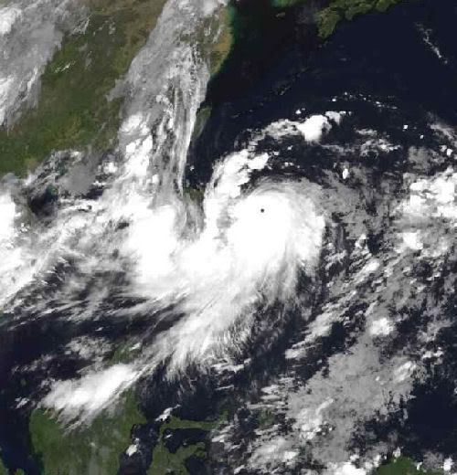
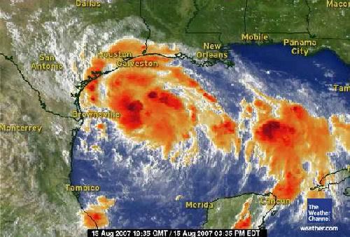
Tropical Storm ERIN... geen orkaan, maar gaat wel voor veel overlast zorgen.
quote:In the Gulf of Mexico, Tropical depression Five took shape last night, and has been upgraded to Tropical Storm Erin at 10 am CT moving northwest toward the southeastern Texas Coast.
Conditions appear favorable for Tropical Storm Erin to be a flooding rain threat into Friday night.
The current forecast track brings this system into the southern Texas Coast on Thursday, but the impacts will be felt along all of the Texas Coast, from Brownsville, through Corpus Christi and Houston, to Lake Charles, LA.
In fact, some showers and thunderstorms well out ahead of Erin, are already on the increase along the Texas Coast and will increase dramatically tonight into Thursday.
Through Thursday evening heavy showers and thunderstorms will bring heavy rainfall of 3 to 5 inches over South Texas, including areas from Brownsville to Corpus Christi, with as much as 2 to 4 inches from Houston to Lake Charles.
Gusty winds will also be on the increase, along with rough surf, especially along the southern Texas Coast. That being said, wind impacts will likely be far less compared to the heavy rain impact.
Meanwhile, our second area of concern, Tropical Storm Dean (60 mph), continues to move quickly west in the Atlantic.
Dean is forecast to become a hurricane by Thursday night or early Friday, and should be threatening the Lesser Antilles as early as Friday. From there, Dean should continue west-northwestward into the Caribbean.
It is too early to tell what, if any, impacts Dean will have on the United States.
Flossie has been downgraded to a tropical storm as of early this morning.
Strong shearing winds are blowing the thunderstorms northeast of the center of circulation and a continued weakening is expected through the day, as Flossie moves west-northwest.
Volgens onderstaande stukje merk je er weinig van op Curacaoquote:Op woensdag 15 augustus 2007 13:49 schreef Joosje112 het volgende:
Mensen, ik zit momenteel op Curacao een aangezien jullie er meer verstabd van hebben dan ik kunnen jullie me vast wel vertellen of het gevaarlijk gaat worden hier...
quote:Voor het zuidelijk gelegen Curacao is de kans (tot en met maandagnacht) dat het tot een orkaan komt, nihil (kleiner dan 0,5 %). De kans dat het tot stormkracht komt is ook al klein: 13%. Voor Sint-Maarten is die laatste waarde een stuk groter: 36%. De kans op orkaankracht is een stuk kleiner met 6%, maar gezien de potentieel verwoestende kracht van dergelijke winden is dit alles toch wel iets om in de gaten te houden. Bovendien vallen, ook als tropische stormen niet tot orkaankracht doorgroeien, er grote hoeveelheden regen.
weer.nl
Gonu was ook een Catogorie 5. In de Arabische Zee.quote:Op woensdag 15 augustus 2007 18:17 schreef ETA het volgende:
Sepat heeft om 18:00 UTC een gemiddelde windsnelheid van 155mph en gusts van 190mph, en mag zich daarom nu officieel een Supertyphoon noemen, een echte categorie 5. Volgens mij eerste van het seizoen.
TROPICS GETTING VERY ACTIVE NOW WITH OUR FIRST HURRICANE CLOSE AT HAND
Dus meer stormen mogelijk vlak na Dean, Erin...
(hurricanetrack)quote:I was just looking at a satellite loop of Dean and noticed how large it seems to have become tonight. Also, the outflow, or the air that is thrown out in a clock-wise fashion at the upper levels of the atmosphere, is impressive. Dean is poised to be a significant hurricane. People in the Lesser Antilles need to be preparing now for Dean and a hurricane watch has been posted accordingly. Let us hope that Dean does not get out of control before reaching the islands of the eastern Caribbean.
I still see the major global models keeping Dean on a southerly track through the Caribbean Sea. This would place Jamaica and the Yucatan very much in harm's way in less than a week. Dean is really moving fast and this will put it in the NW Caribbean sooner rather than later. As I check the latest GFS operational model run come in, it again insists that Dean will stay south of the United States and impact Mexico. Perhaps this will be the fate, perhaps not. Still too early to tell but we may have more clues tomorrow night and Friday as the NOAA G-IV jet is going to sample the environment ahead of Dean for better data input to the global models. So far, they have done pretty well once they stopped flip-flopping. Consistency is the key and the major models are fairly consistent right now.
Erin is about to come ashore in Texas and will be a big rain maker over the next several days. Be careful if you live in that area- pay attention to local information and media reports on flooding conditions, etc. We have to be smart here and not let a tropical storm cause loss of life. Erin should weaken quickly once inland later on Thursday but those rains will likely continue for a couple of more days.
Elsewhere, I see other disturbances about to make their way across the tropical Atlantic and indeed several computer models depict even more development soon. It is going to be quite a hurricane season and perhaps a stark contrast to last year. Be ready! I will have more info and updates here by mid-morning Thursday.
Dus meer stormen mogelijk vlak na Dean, Erin...
Dean upgraded to Hurricane
Hurricane Dean formed in the open Atlantic early Thursday and headed toward the Lesser Antilles in the Caribbean, forecasters said.
Hurricane warnings were issued for the islands of Dominica and St. Lucia by their local governments. Hurricane watches were in effect for the islands of Martinique and Guadeloupe and its dependencies, Saba and St. Eustaties.
At 5 a.m. EDT, Dean was centered about 485 miles east of Barbados and about 590 miles east of Martinique, according to the National Hurricane Center. It was moving west near 24 mph, and was expected to continue the same path for the next 24 hours.
Maximum sustained winds were near 75 mph, above the 74-mph threshold for a hurricane. Dean is a Category 1 hurricane and is expected to strengthen during the next 24 hours, forecasters said.
Out in the Gulf, Shell Oil Co. evacuated 188 people from offshore facilities in the path of Tropical Storm Erin.
A tropical storm warning was posted for the Texas coast from San Luis Pass, about 50 miles southwest of Houston, southward to the border. A tropical storm warning means that tropical storm conditions are expected within 24 hours. A tropical storm watch for northern Mexico was canceled.
Three to 8 inches of rain was possible along the middle Texas coast, the hurricane center said, with a storm surge of up to 3 feet above normal tide levels north of where the center makes landfall.
The U.S. Census Bureau said Wednesday that 4 million people could feel the storm's effects.
A series of storms this summer poured record rainfall across Texas and parts of Oklahoma and Kansas, with one July storm dropping 17 inches of rain in 24 hours. Flooding was widespread across all three states. It brought Texas out of drought status for the first time in more than a decade.
At least 16 deaths have been blamed on flooding since mid-June.
In the Pacific, Flossie was downgraded from a hurricane to a tropical storm after sideswiping Hawaii's Big Island with only intermittent rain and moderate winds.
It was a close call: Flossie approached the biggest and southernmost of the Hawaiian Islands with winds as high as 140 miles per hour earlier in the week, making it a Category 4 storm. If it had made landfall, the powerful hurricane would have been the first to hit the isles since Iniki slammed Kauai in 1992, killing six people.
"The storm that never was," said Karin Funai as she chatted with friends over coffee at the Pahala Town Cafe. "This was nothing."
Hurricane specialists expect this year's Atlantic hurricane season — June 1 to Nov. 30 _to be busier than average, with as many as 16 tropical storms, nine of them strengthening into hurricanes. Ten tropical storms developed in the Atlantic last year, but only two made landfall in the United States.
Tropical Storm Erin
CORPUS CHRISTI, Texas — Some vacationers packed up while others vowed to wait out Tropical Storm Erin and its torrential rainfall as it headed for flood-weary Texas early Thursday.
Erin was not expected to gain hurricane strength before making landfall Thursday morning, which was why some said they wouldn't abandon long-planned trips to the coast.
"It's not a hurricane. I ain't worried. If they say don't evacuate, I'm not going to worry about it," said Matt Sandlin of Amarillo, who was on a beach near Corpus Christi with his family on Wednesday as the wind whipped up and the horizon darkened with clouds. "Unless I see a shark or whale go flying by, I'm good."
Gov. Rick Perry ordered emergency vehicles and personnel, including National Guard troops, to the Harlingen and Corpus Christi areas.
"Because storms have saturated much of our state this summer, many communities in this storm's projected path are at high risk of dangerous flash flooding," Perry said in a statement.
Cameron County Judge Carlos Cascos, the top elected official for the state's southernmost county, urged residents to evacuate trailers and mobile homes on South Padre Island.
Corpus Christi hadn't asked for any evacuations, said Ted Nelson, a city spokesman, and was keeping only a handful of people at the emergency operations center overnight.
"We're just advising folks to review their own personal emergency plans and look around your yard and remove any loose items," he said.
Nelson said that with 3 1/2 months left in the Atlantic hurricane season, the incoming storm was "a nice little wake-up call" for people to make sure they are prepared for more severe weather.
Some weren't taking any chances.
"We came out to get as much beach time in as possible," said John Cullison of the Dallas area, who was vacationing with his family and planned to leave southern Texas Thursday instead of Friday. "After the hurricanes from a few years ago, you have to take it kind of serious."
Erin formed late Tuesday as the fifth depression of the Atlantic hurricane season and was upgraded to a tropical storm Wednesday when its maximum sustained speed hit 40 mph. The threshold for tropical storm status is 39 mph.
At 2 a.m. EDT, the storm was centered about 110 miles southeast of Corpus Christi and about 215 miles south-southwest of Galveston, according to the National Hurricane Center in Miami. Its top wind speed remained at 40 mph.
Erin was moving toward the west-northwest at around 12 mph and was expected to continue following that track for at least 24 hours. Its center was expected to be very near the Texas coast on Thursday morning, the hurricane center said.
Erin was likely too close to land to gain enough wind speed to become a hurricane, with sustained wind of at least 74 mph, said National Weather Service forecaster Tony Abbott in Brownsville. But the center said late Wednesday it could strengthen slightly before landfall.
Isolated tornadoes were possible along the middle Texas Gulf Coast on Thursday, the center said.
Hurricane Dean formed in the open Atlantic early Thursday and headed toward the Lesser Antilles in the Caribbean, forecasters said.
Hurricane warnings were issued for the islands of Dominica and St. Lucia by their local governments. Hurricane watches were in effect for the islands of Martinique and Guadeloupe and its dependencies, Saba and St. Eustaties.
At 5 a.m. EDT, Dean was centered about 485 miles east of Barbados and about 590 miles east of Martinique, according to the National Hurricane Center. It was moving west near 24 mph, and was expected to continue the same path for the next 24 hours.
Maximum sustained winds were near 75 mph, above the 74-mph threshold for a hurricane. Dean is a Category 1 hurricane and is expected to strengthen during the next 24 hours, forecasters said.
Out in the Gulf, Shell Oil Co. evacuated 188 people from offshore facilities in the path of Tropical Storm Erin.
A tropical storm warning was posted for the Texas coast from San Luis Pass, about 50 miles southwest of Houston, southward to the border. A tropical storm warning means that tropical storm conditions are expected within 24 hours. A tropical storm watch for northern Mexico was canceled.
Three to 8 inches of rain was possible along the middle Texas coast, the hurricane center said, with a storm surge of up to 3 feet above normal tide levels north of where the center makes landfall.
The U.S. Census Bureau said Wednesday that 4 million people could feel the storm's effects.
A series of storms this summer poured record rainfall across Texas and parts of Oklahoma and Kansas, with one July storm dropping 17 inches of rain in 24 hours. Flooding was widespread across all three states. It brought Texas out of drought status for the first time in more than a decade.
At least 16 deaths have been blamed on flooding since mid-June.
In the Pacific, Flossie was downgraded from a hurricane to a tropical storm after sideswiping Hawaii's Big Island with only intermittent rain and moderate winds.
It was a close call: Flossie approached the biggest and southernmost of the Hawaiian Islands with winds as high as 140 miles per hour earlier in the week, making it a Category 4 storm. If it had made landfall, the powerful hurricane would have been the first to hit the isles since Iniki slammed Kauai in 1992, killing six people.
"The storm that never was," said Karin Funai as she chatted with friends over coffee at the Pahala Town Cafe. "This was nothing."
Hurricane specialists expect this year's Atlantic hurricane season — June 1 to Nov. 30 _to be busier than average, with as many as 16 tropical storms, nine of them strengthening into hurricanes. Ten tropical storms developed in the Atlantic last year, but only two made landfall in the United States.

Tropical Storm Erin
CORPUS CHRISTI, Texas — Some vacationers packed up while others vowed to wait out Tropical Storm Erin and its torrential rainfall as it headed for flood-weary Texas early Thursday.
Erin was not expected to gain hurricane strength before making landfall Thursday morning, which was why some said they wouldn't abandon long-planned trips to the coast.
"It's not a hurricane. I ain't worried. If they say don't evacuate, I'm not going to worry about it," said Matt Sandlin of Amarillo, who was on a beach near Corpus Christi with his family on Wednesday as the wind whipped up and the horizon darkened with clouds. "Unless I see a shark or whale go flying by, I'm good."
Gov. Rick Perry ordered emergency vehicles and personnel, including National Guard troops, to the Harlingen and Corpus Christi areas.
"Because storms have saturated much of our state this summer, many communities in this storm's projected path are at high risk of dangerous flash flooding," Perry said in a statement.
Cameron County Judge Carlos Cascos, the top elected official for the state's southernmost county, urged residents to evacuate trailers and mobile homes on South Padre Island.
Corpus Christi hadn't asked for any evacuations, said Ted Nelson, a city spokesman, and was keeping only a handful of people at the emergency operations center overnight.
"We're just advising folks to review their own personal emergency plans and look around your yard and remove any loose items," he said.
Nelson said that with 3 1/2 months left in the Atlantic hurricane season, the incoming storm was "a nice little wake-up call" for people to make sure they are prepared for more severe weather.
Some weren't taking any chances.
"We came out to get as much beach time in as possible," said John Cullison of the Dallas area, who was vacationing with his family and planned to leave southern Texas Thursday instead of Friday. "After the hurricanes from a few years ago, you have to take it kind of serious."
Erin formed late Tuesday as the fifth depression of the Atlantic hurricane season and was upgraded to a tropical storm Wednesday when its maximum sustained speed hit 40 mph. The threshold for tropical storm status is 39 mph.
At 2 a.m. EDT, the storm was centered about 110 miles southeast of Corpus Christi and about 215 miles south-southwest of Galveston, according to the National Hurricane Center in Miami. Its top wind speed remained at 40 mph.
Erin was moving toward the west-northwest at around 12 mph and was expected to continue following that track for at least 24 hours. Its center was expected to be very near the Texas coast on Thursday morning, the hurricane center said.
Erin was likely too close to land to gain enough wind speed to become a hurricane, with sustained wind of at least 74 mph, said National Weather Service forecaster Tony Abbott in Brownsville. But the center said late Wednesday it could strengthen slightly before landfall.
Isolated tornadoes were possible along the middle Texas Gulf Coast on Thursday, the center said.


Dean wordt er ééntje om goed in de gaten te houden, het lijkt een actief seizoen te worden in tegenstelling tot vorig jaar.
* I intend to live forever, so far so good! *

Erin is inmiddels een tropische depressie.
Dean wordt sterker in de verwachtingen, met sustained winds van 115 KT (213km/h) en windstoten tot 140 KT (259km/h), wat Dean in de Cat. 4 brengt.
Dean wordt sterker in de verwachtingen, met sustained winds van 115 KT (213km/h) en windstoten tot 140 KT (259km/h), wat Dean in de Cat. 4 brengt.
/ ¦ ¦ / ¦ ¦
als dit uitkomt betekent dat een ramp voor kust Texas/Louisiana en al die olieinstallaties daar.
159 knots 295km/h
http://moe.met.fsu.edu/cgi-bin/gfdltc2.cgi?time=2007081612-dean04l&field=Sea+Level+Pressure&hour=Animation
hangt er dus vanaf of hij over Yucatan gaat of niet.
maar meer modellen gaat uit van noordwestelijke richting dan precies tussen Cuba en Yucatan zo naar Texas/Louisiana.

159 knots 295km/h
http://moe.met.fsu.edu/cgi-bin/gfdltc2.cgi?time=2007081612-dean04l&field=Sea+Level+Pressure&hour=Animation
hangt er dus vanaf of hij over Yucatan gaat of niet.
maar meer modellen gaat uit van noordwestelijke richting dan precies tussen Cuba en Yucatan zo naar Texas/Louisiana.
Dostojewski: "Je kunt je niet van je eigen gezond verstand overtuigen door je buurman op te sluiten."
Taiwan wordt hard getroffen. Als een categorie 4 gaat ie aan land bij Taiwan en vervolgens naar China.
Het zal me niets verbazen, als Hurricane DEAN ook nog een categorie 5 gaat worden.
Het zal me niets verbazen, als Hurricane DEAN ook nog een categorie 5 gaat worden.
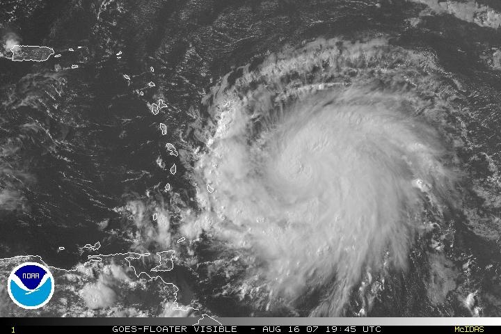
Gisteravond werden we getroffen door een freak storm, je kan het witte plukje zien dat net voor de typhoon uitgaat. Forse regenbuien gepaard met ongelovelijk lange donderslagen. Een voorbode voor de big one Momenteel is het rustig en het zonnetje schijnt, maar over 24 ur gaat het spel beginnen, dan zal Sepat zo goed als zeker aan land komen...quote:Op donderdag 16 augustus 2007 13:58 schreef DrankBakje het volgende:
Sepat
[afbeelding]
Oog is mooi te zien
Zal behoorlijk tekeer gaan in taiwan denk ik.
Een directe hit op Taipei is onwaarschijnlijk, maar zal wel gebukt gaan onder troppische storm kracht winden. Op werk hebben ze inmiddels grote planken voor de ramen geplaatst. Als het mogelijk is zal ik morgen wel wat fotos maken, misschien dat ik nog wat interesante kiekjes kan maken
Inmiddels is Sepat afgezwakt en zal "maar" als een cat 4 aan land komen. Ik word toch lichtelijk nerveus nu ik de satelietbeelden zie, wat een gigantische monster is het:

update:
Meeste tracking sites hebben de verwachte pad van Sepat naar het noorden verschoven. Japanse weerbureau voorspelt dat Taipei toch nog dik in de gevarenzone zit..... Had ik eigenlijk niet echt meer verwacht. Ik denk dat ik toch echt serieuze voorbereidingen moet treffen. Collegas hebben het er ook al over voorbereidingen, en zij hebben toch wel meeste ervaringen met dit soort dingen....

Update 2
Here we go, grote golf grijze wolken drijft nu binnen.....

[ Bericht 15% gewijzigd door ETA op 17-08-2007 06:26:38 ]
Totaal Travel 04-24: 87 reizen, 151 vliegtickets, 58 landen, 6 continenten, 949 reisdagen, 163.804 foto's
Mijn reisfotos!
Mijn reisfotos!
Black swans matter

Zo, ik heb mijn fietstocht door de bergen van midden-Taiwan afgebroken en ben weer veilig terug in Taipei. Hier gebeurt normaal niks, maar in de bergen is het gevaarlijk door aardverschuivingen e.d.
"If you want to make God laugh, tell him about your plans"
Mijn reisverslagen
Mijn reisverslagen
Ben je net op tijd terug Selang Ik hoop dat je beetje hebt genoten van je rit
Taipei Times schrijft:
Taipei Times schrijft:
quote:Weather bureau issues alert for Typhoon Sepat
BATTEN THE HATCHES: If it holds its course, the powerful typhoon could affect the country early today and make landfall in the southeast tonight
STAFF WRITER, WITH CNA
Friday, Aug 17, 2007, Page 1
The Central Weather Bureau followed up its sea warning for Typhoon Sepat yesterday morning with a land warning at 8:30pm last night as the storm continued to approach.
At 8pm, the typhoon was centered 640km southeast of Taitung and was moving northwesterly at 20kph, packing maximum sustained winds of 191kph.
Forecasters said Sepat posed a threat to shipping southeast of Taiwan and in the Bashi Channel.
Lu Kuo-chen (呂國臣), a section chief at the Weather Forecast Center, said the eye of Sepat was clearly visible on satellite pictures, which indicated that it could be very destructive. With a radius of 250km, Sepat covers an area of 196,250km2 -- greater than the area of Taiwan, he said.
If Sepat stays on its current course, the fringe of the typhoon could affect the island early today and possibly make landfall over southeastern Taiwan tonight, the bureau said.
Airlines have canceled some flights and they urged passengers to confirm their flights well ahead of the scheduled departures.
All Uni Air flights to Taitung from Taipei after noon today have been canceled, as has the 8:40pm Kaohsiung to Taipei Uni Air flight, the company said.
All Far Eastern Air Transport flights after noon today have been canceled, the company said.
TransAsia Airways has canceled its afternoon flights to Hualien and Pingtung, as well as its flights to Kaohsiung and Tainan after 6pm, while Mandarin Airlines has canceled its flights to Kaohsiung, Hualien and Makung City today.
This story has been viewed 1141 times.
Totaal Travel 04-24: 87 reizen, 151 vliegtickets, 58 landen, 6 continenten, 949 reisdagen, 163.804 foto's
Mijn reisfotos!
Mijn reisfotos!
ETA, heb je ook foto's gemaakt van die binnendrijvende wolken/lucht?
Ben ik wel benieuwd naar hoe dat zoal gaat daar nu
Sterkte vast.. en zorg dat je d'r veilig doorheen komt
Ben ik wel benieuwd naar hoe dat zoal gaat daar nu
Sterkte vast.. en zorg dat je d'r veilig doorheen komt
Dean struggling to maintain strength
Hurricane Dean has is being maintained as a weak category 2 hurricane with winds of 100 mph and a central pressure of 976 mb, but this may be generous. Judging by satellite imagery, Dean has been weakening and is looking much more ragged than he did this morning. While there is strong outflow in all quadrants, the circulation itself does not look to healthy.
Infrared image of Dean
Not only is Dean's general circulation looking much more ragged, but his eye has also completely disappeared. Despite my utmost effort, I was unable to locate a significant eyewall signature in any of the infrared, water vapor, or microwave imagery. There appears to only be a central dense overcast area.
Why exactly Dean is having so much trouble seems to be the question of the hour. The most obvious culprit that I can come up with is the broad area of dry air to the northwest of Dean.
Water vapor of Dean - Darker blue areas represent dry air
Like a '49er looking for gold, Hurricane Dean is moving westward at a very rapid clip, topping 25 mph at last report. This should enable Dean to get out of the fairly dry air it's in now and move into the Caribbean quickly where factors are more favorable for strengthening. Despite the dry air, it seems as if Dean isn't going to be held down for long. The computer models are quite clear expecting Dean to strengthen. While not all models can properly resolve Dean's intensity due to limited spatial resolution, they nearly all capture the strengthening trend that we expect.
Hurricane Dean has is being maintained as a weak category 2 hurricane with winds of 100 mph and a central pressure of 976 mb, but this may be generous. Judging by satellite imagery, Dean has been weakening and is looking much more ragged than he did this morning. While there is strong outflow in all quadrants, the circulation itself does not look to healthy.

Infrared image of Dean
Not only is Dean's general circulation looking much more ragged, but his eye has also completely disappeared. Despite my utmost effort, I was unable to locate a significant eyewall signature in any of the infrared, water vapor, or microwave imagery. There appears to only be a central dense overcast area.
Why exactly Dean is having so much trouble seems to be the question of the hour. The most obvious culprit that I can come up with is the broad area of dry air to the northwest of Dean.

Water vapor of Dean - Darker blue areas represent dry air
Like a '49er looking for gold, Hurricane Dean is moving westward at a very rapid clip, topping 25 mph at last report. This should enable Dean to get out of the fairly dry air it's in now and move into the Caribbean quickly where factors are more favorable for strengthening. Despite the dry air, it seems as if Dean isn't going to be held down for long. The computer models are quite clear expecting Dean to strengthen. While not all models can properly resolve Dean's intensity due to limited spatial resolution, they nearly all capture the strengthening trend that we expect.
4 Doden door tropische storm in Texas
De tropische storm Erin heeft in de staat Texas vier levens geëist. Het natuurgeweld heeft ook een enorme ravage aangericht.
Houston
In Houston, de grootste stad van Texas, zijn door zware regen overstromingen ontstaan. Erin kwam aan land met een snelheid van 280 kilometer per uur en ging landinwaarts met grote rukwinden.
Zware regenval
Door de zware regenval stortte het dak van een winkel in Houston in. Daarbij kwam een persoon om het leven. Drie anderen overleden bij verkeersongelukken.
============
wacht ff... 280 km/u ?
dat lijkt me toch verdomd sterk? dan was het een cat.5 geweest?
Black swans matter
Ik kwam vanmorgen met de bus vanaf Taichung en toen zag je mooi dat de westkant blauwe lucht was en aan de oostkant allemaal hele mooie wolken. Maar het is dus niet zo dat je een massieve muur van wolken op je af ziet komen ofzo. Het gaat heel geleidelijk.quote:Op vrijdag 17 augustus 2007 08:06 schreef Frutsel het volgende:
ETA, heb je ook foto's gemaakt van die binnendrijvende wolken/lucht?
Vaak is het de dag voordat de typhoon komt juist heel mooi weer met een blauwe lucht en een ontzettend felle zon. Het is net alsof de naderende typhoon het vocht uit de lucht wegtrekt ofzo waardoor je zo'n felle zon krijgt. Gisteren was dat dus ook zo. Ben flink verbrand
Verder is zo'n typhoon meestal niet echt spectaculair. Het is gewoon 1 of 2 dagen kutweer met vooral heel veel regen. Er zijn korte periodes met hele sterke wind. De meeste schade wordt veroorzaakt door instortende berghellingen die wegspoelen door de grote hoeveelheid water. Maar in een stad als Taipei gebeurt er meestal weinig. We hadden wel in 2004 of 2005 een keer binnen 48 uur 1300mm regen in Taipei.
"If you want to make God laugh, tell him about your plans"
Mijn reisverslagen
Mijn reisverslagen
Hey Selang, als ik nu naar buiten kijk, betekend dat de typhoon is aangekomen? Het was plotseling donker buiten en zie geen hol meer door de regen......... kut, had mn camera moeten meenemen vandaag
Totaal Travel 04-24: 87 reizen, 151 vliegtickets, 58 landen, 6 continenten, 949 reisdagen, 163.804 foto's
Mijn reisfotos!
Mijn reisfotos!
Idd. Die 280 km/u slaan nergens op. Anders hadden wij het hier toch echt wel geweten dacht ik zoquote:Op vrijdag 17 augustus 2007 08:28 schreef Frutsel het volgende:
4 Doden door tropische storm in Texas
De tropische storm Erin heeft in de staat Texas vier levens geëist. Het natuurgeweld heeft ook een enorme ravage aangericht.
Houston
In Houston, de grootste stad van Texas, zijn door zware regen overstromingen ontstaan. Erin kwam aan land met een snelheid van 280 kilometer per uur en ging landinwaarts met grote rukwinden.
Zware regenval
Door de zware regenval stortte het dak van een winkel in Houston in. Daarbij kwam een persoon om het leven. Drie anderen overleden bij verkeersongelukken.
============
wacht ff... 280 km/u ?
dat lijkt me toch verdomd sterk? dan was het een cat.5 geweest?
Black swans matter
Ja dat is em.quote:Op vrijdag 17 augustus 2007 10:54 schreef ETA het volgende:
Hey Selang, als ik nu naar buiten kijk, betekend dat de typhoon is aangekomen? Het was plotseling donker buiten en zie geen hol meer door de regen......... kut, had mn camera moeten meenemen vandaag
Ik was net ff buiten ff wat eten, windstil en geen regen. Een kwartiertje later loop ik terug en toen kwam het met bakken uit de hemel. Nu is het weer even rustig. Maar de echt harde wind komt pas als je dichter bij het oog zit (vannacht waarschijnlijk).
"If you want to make God laugh, tell him about your plans"
Mijn reisverslagen
Mijn reisverslagen
Ik zit in Sijhih/Hsichih/XiZhi (romanization ),Taipei county. Tweede "golf" lijkt nu over te trekken, het is weer pikkedonker. Inmiddels waarschuwingberichten over de bedrijfsspeakers, volgens mij is het advies om naar huis te gaan (ik versta nauwelijks chinees ), maar niemand reageert.... anyway, ik ga over 20 minuten ook maar naar huis om nog ff snel wat inkopen te doen. Hopelijk kan ik een taxi pakken, maar dat zit er waarschijnlijk niet in met dit weer....
Overigens hoorde ik wel net dat paar jaar geleden het gebied waar ik nu zit zwaar was overstroomd na een typhoon. Niet erg prettig om te horen aangezien ik op de begane grond woon
Volgens mij staat hier: http://www.cpa.gov.tw/ dat alle scholen en bedrijven dicht gaan vanavond in en rondom taipei.
taipei heeft momenteel het zwaarst qua regen:

Totaal Travel 04-24: 87 reizen, 151 vliegtickets, 58 landen, 6 continenten, 949 reisdagen, 163.804 foto's
Mijn reisfotos!
Mijn reisfotos!
Black swans matter
Ja balen dat het in het weekend is, anders had je een typhoon holidayquote:Op vrijdag 17 augustus 2007 11:41 schreef ETA het volgende:
Volgens mij staat hier: http://www.cpa.gov.tw/ dat alle scholen en bedrijven dicht gaan vanavond in en rondom taipei.
Vorig jaar hadden we niet één typhoon holiday, maar het jaar ervoor 3 of 4
"If you want to make God laugh, tell him about your plans"
Mijn reisverslagen
Mijn reisverslagen
hee orkaan dean komt toch niet dichtbij curacao want daar ga ik maandag heen op vakantie?
Word nu wel bang daarvoor.
Word nu wel bang daarvoor.
Dean zal daar niet echt komen.. daar hoef je je niet druk om te maken. Hooguit wat regen nog.. op maandag want hij komt morgen in dat gebied. Hoe lang blijf je daar op vakantie?quote:Op vrijdag 17 augustus 2007 12:13 schreef sangirl25 het volgende:
hee orkaan dean komt toch niet dichtbij curacao want daar ga ik maandag heen op vakantie?
Word nu wel bang daarvoor.
not at all, 0,5% kans daarop.quote:Op vrijdag 17 augustus 2007 12:13 schreef sangirl25 het volgende:
hee orkaan dean komt toch niet dichtbij curacao want daar ga ik maandag heen op vakantie?
Word nu wel bang daarvoor.
Passion for Christ
Sorry hoor, maar als jij NU geen camera bij je hebt ben je toch echt wel een enorme paardenlul.quote:Op vrijdag 17 augustus 2007 10:54 schreef ETA het volgende:
Hey Selang, als ik nu naar buiten kijk, betekend dat de typhoon is aangekomen? Het was plotseling donker buiten en zie geen hol meer door de regen......... kut, had mn camera moeten meenemen vandaag
het is ondertussen al avond en donker buiten, dus veel zie je niet misschien dat ik morgenochten wel ff op pad ga, maar verwacht eigenlijk niet veel spectaculairs nu de typhoon richting het zuiden is gegaan,quote:Op vrijdag 17 augustus 2007 15:12 schreef Gallard het volgende:
[..]
Sorry hoor, maar als jij NU geen camera bij je hebt ben je toch echt wel een enorme paardenlul.
Totaal Travel 04-24: 87 reizen, 151 vliegtickets, 58 landen, 6 continenten, 949 reisdagen, 163.804 foto's
Mijn reisfotos!
Mijn reisfotos!
Dean wordt toch erg sterk, de verwachtingen gaan richting 130 KT, >136KT is cat 5. 130 KT = 241km/h en de winstoten gaan tot 160 KT, 296km/h. Poor Yucatan...
/ ¦ ¦ / ¦ ¦
holy shit...quote:Op vrijdag 17 augustus 2007 17:05 schreef highway101 het volgende:
Dean wordt toch erg sterk, de verwachtingen gaan richting 130 KT, >136KT is cat 5. 130 KT = 241km/h en de winstoten gaan tot 160 KT, 296km/h. Poor Yucatan...
* I intend to live forever, so far so good! *
nou poor Yucatan...
lijkt dat hij precies door de Straat Yucatán heen gaat en dan zo richting Galveston/Houston.
al die olieplatformen en raffinaderijen stuk.
en door Erin is daar al enorm veel regen gevallen dus grond is compleet verzadigd.
NHC wil hier nog niet voor gaan waarschuwen om geen paniek te veroorzaken.
lijkt dat hij precies door de Straat Yucatán heen gaat en dan zo richting Galveston/Houston.
al die olieplatformen en raffinaderijen stuk.
en door Erin is daar al enorm veel regen gevallen dus grond is compleet verzadigd.
NHC wil hier nog niet voor gaan waarschuwen om geen paniek te veroorzaken.


Dostojewski: "Je kunt je niet van je eigen gezond verstand overtuigen door je buurman op te sluiten."
...DEAN STRENGTHENS TO A MAJOR HURRICANE WITH 125 MPH WINDS...
categorie 3 nu.
vanaf 131 mph is het een categorie 4.
categorie 3 nu.
vanaf 131 mph is het een categorie 4.
Dostojewski: "Je kunt je niet van je eigen gezond verstand overtuigen door je buurman op te sluiten."

quote:Op vrijdag 17 augustus 2007 20:10 schreef Caesu het volgende:
...DEAN STRENGTHENS TO A MAJOR HURRICANE WITH 125 MPH WINDS...
categorie 3 nu.
vanaf 131 mph is het een categorie 4.
klopt toch helemaal niks van.quote:***************************************
Doden in Texas door tropische storm
***************************************
` Door de tropische storm Erin zijn in
de Amerikaanse staat Texas zeven mensen
omgekomen.Er zijn 3 vermisten.De storm
kwam aan land met een snelheid van 280
km per uur en gaat gepaard met zware
regenval.Houston en San Antonio staan
voor een deel onder water.
De eerste orkaan van het seizoen,Dean,
wint in het Caribisch gebied steeds
meer aan kracht.Hij is nu ingeschaald
in 3,de op twee na zwaarste categorie.
Dean is over St.Lucia en Martinique
getrokken,waarbij één dode is gemeld.Nu
bereidt Jamaica zich voor op de komst
van Dean.Op het Mexicaanse eiland
Yucatan kan Dean nog krachtiger worden.
***************************************
kwam met windsnelheid 65km/h uur aan land.
Dostojewski: "Je kunt je niet van je eigen gezond verstand overtuigen door je buurman op te sluiten."
Mogelijk wordt Dean een zware Catogorie 5. Volgens sommige berekeningen zouden er windvlagen van 330km per uur kunnen gaan komen. Op dit moment is Dean een Catogorie 3.
Over slachtoffers in Taiwan door de Typhoon Sepat is nog niets bekend. Sepat is als een Catogorie 3 aan land gegaan. Achter Sepat lijkt zich een nieuwe storm te ontwikkelen.
Ook in de Atlantische Oceaan is weer een redelijk actief gebied ontstaan. Misschien dat daar ook weer een storm uit ontstaan.
Dit is ook het geval in de E.Pacific.
[Update]
Er is zonet de 1st dode gemeld door Dean.
Op St. Lucia is een man de rivier in geblazen en verdronk toen hij een koe wilde redden.
Hij trekt volgens de laatste berichten precies over Jamaica heen. Dat zal binnen 2 dagen gaan
gebeuren. Als een categorie 4
gebeuren. Als een categorie 4

Ja,
Jamaica lijkt er zwaar van langs te krijgen.
De laatste voorspellingen voor Jamaica :
Wind : 241km
Windvlagen : 296km
[Update]
Het dondetal door Orkaan Dean is opgelopen tot 4.
[Update]
Dane is nu een Catogorie 4 !!
[ Bericht 16% gewijzigd door HurricaneTown op 18-08-2007 02:15:23 ]
Jamaica lijkt er zwaar van langs te krijgen.
De laatste voorspellingen voor Jamaica :
Wind : 241km
Windvlagen : 296km
[Update]
Het dondetal door Orkaan Dean is opgelopen tot 4.
[Update]
Dane is nu een Catogorie 4 !!
[ Bericht 16% gewijzigd door HurricaneTown op 18-08-2007 02:15:23 ]
inmiddels ook categorie 4 alweer.quote:REPORTS FROM AN AIR FORCE RESERVE RECONNAISSANCE AIRCRAFT INDICATE
THAT MAXIMUM SUSTAINED WINDS HAVE INCREASED TO AT LEAST 135
MPH...215 KM/HR...WITH HIGHER GUSTS. DEAN IS NOW A CATEGORY FOUR
HURRICANE ON THE SAFFIR-SIMPSON HURRICANE SCALE. SOME ADDITIONAL
STRENGTHENING IS FORECAST DURING THE NEXT 24 HOURS.
ramp voor Jamaica als hij idd recht er overheen gaat.
update:
Dean is razendsnel sterker aan het worden.quote:DATA FROM THE AIR FORCE RESERVE HURRICANE HUNTER AIRCRAFT CURRENTLY
INVESTIGATING HURRICANE DEAN INDICATE THAT MAXIMUM SUSTAINED WINDS
HAVE INCREASED TO 145 MPH...CATEGORY FOUR ON THE SAFFIR-SIMPSON
HURRICANE SCALE.
als het zo door gaat is hij over een uur of twee al een categorie 5 ! (155mph)
dat is dagen eerder dan was voorspeld...
als je op Jamaica woont moet je echt wegwezen.
[ Bericht 20% gewijzigd door Caesu op 18-08-2007 03:42:33 ]
Dostojewski: "Je kunt je niet van je eigen gezond verstand overtuigen door je buurman op te sluiten."
De verwachtingen zijn ook stevig;
170 KT = 315km/h
140 KT = 259km/h = Categorie 5quote:FORECAST VALID 21/0000Z 20.0N 85.5WMAX WIND 140 KT...GUSTS 170 KT.
170 KT = 315km/h
/ ¦ ¦ / ¦ ¦
nee, maar als 'ie dat vlak voor de kust doet dan wordt het wel een puinzooi.quote:Op zaterdag 18 augustus 2007 12:05 schreef Fredo55 het volgende:
Een cat. 5 hurricane zal natuurlijk nooit lang zijn enorme kracht handhaven...
[b]Op maandag 6 september 2010 00:28 schreef tong80 het volgende:[/b]
GVD Wat moet jij een trotse vader zijn :)
:P
GVD Wat moet jij een trotse vader zijn :)
:P
De regen alleen is al genoeg voor een ramp;
20 inch is meer dan een halve meter regen.quote:STORM TOTAL RAINFALL AMOUNTS OF 5 TO 10 INCHES CAN BE EXPECTED OVERJAMAICA...WITH MAXIMUM AMOUNTS OF UP TO 20 INCHES.
/ ¦ ¦ / ¦ ¦
midden volgende week lijken er twee nieuwe stormen/hurricanes te ontstaan.
eentje bij de Bahamas en dan richting Florida.
en eentje die ongeveer dezelfde route als Dean volgt.
eentje bij de Bahamas en dan richting Florida.
en eentje die ongeveer dezelfde route als Dean volgt.

Dostojewski: "Je kunt je niet van je eigen gezond verstand overtuigen door je buurman op te sluiten."
Ff een tvp.
Mijn vriendin is op vakantie naar Mexico, schijnt er dus middenin te zitten..
In het witte rondje zit ze, stadje Cancun te Mexico.:
Mijn vriendin is op vakantie naar Mexico, schijnt er dus middenin te zitten..
In het witte rondje zit ze, stadje Cancun te Mexico.:

D200|D50|50 1.8|18-55|70-300|SB600
The Jamaican government issued a hurricane warning late Saturday morning, meaning hurricane conditions are expected within 24 hours, the U.S. National Hurricane Center said.quote:Op zaterdag 18 augustus 2007 18:09 schreef cyberrobin het volgende:
Ff een tvp.
Mijn vriendin is op vakantie naar Mexico, schijnt er dus middenin te zitten..
In het witte rondje zit ze, stadje Cancun te Mexico.:
[afbeelding]
Forecasters fear Dean will be a destructive Category 5 monster packing 155 mph winds by the time it reaches Jamaica.
Even worse could be yet to come. By Monday, as Dean nears Cancun and other tourist areas along Mexico's eastern Yucatan coast, its sustained winds could be 160 mph, with gusts approaching 200 mph -- wreaking new havoc on an area heavily damaged just two years ago by Hurricane Wilma.
CNN
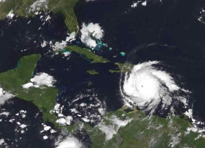
Tja, Cancun is zowieso vrij vaak de pineut. Ik neem aan dat die vriendin van het risico afwist. Tijdens het orkaanseizoen naar Cancun gaan is meestal niet zonder risico's.
/ ¦ ¦ / ¦ ¦
De koers kan nog wel veranderen natuurlijk.
Dean kan ook b.v. tussen cuba en mexico trekken. En daarna richting Texas.
Dean kan ook b.v. tussen cuba en mexico trekken. En daarna richting Texas.

Dean gezien vanuit ISS
Dostojewski: "Je kunt je niet van je eigen gezond verstand overtuigen door je buurman op te sluiten."
Wel ff de foto omdraaien.....quote:
<a href="http://www.vwkweb.nl/" rel="nofollow" target="_blank">Vereniging voor weerkunde en klimatologie</a>
<a href="http://www.estofex.org/" rel="nofollow" target="_blank">ESTOFEX</a>
<a href="http://www.estofex.org/" rel="nofollow" target="_blank">ESTOFEX</a>

Jamaica en de Caymaneilanden worden compleet verwoest morgen en overmorgen.
over het midden van Jamaica incl. Kingston CAT5 hurricane.
ook Haïti krijgt het zwaar. enig pluspuntje is dat hij erg snel gaat dus er valt minder neerslag.
dit gaat over de het GFDL model die een meer noordelijke koers laat zien.quote:THERE COULD BE VERY UNCERTAIN DAYS AHEAD SINCE THE GFDL HAS HAD A VERY
RELIABLE TRACK RECORD.
hurricanes willen nog al eens tegen verwachting in opeens noordelijker of zelfs oostelijker gaan in de Golf van Mexico.
http://www.nhc.noaa.gov/archive/2005/RITA_graphics.shtml
Rita bijvoorbeeld in 2005 leek eerst naar Mexico te gaan, maar kwam uiteindelijk aan land bij de grens Texas/Louisiana.
Dostojewski: "Je kunt je niet van je eigen gezond verstand overtuigen door je buurman op te sluiten."
ze moeten niet ondersteboven foto's makenquote:
today.reuters.co.ukquote:Bush approves emergency declaration before Dean
By Carlos Barria
KINGSTON/CRAWFORD, Texas, (Reuters) - U.S. President George W. Bush on Saturday approved a pre-landfall emergency declaration for Texas in case the state is hit by Hurricane Dean, White House spokesman Gordon Johndroe said.
The emergency declaration, which was requested by the governor of Texas, will allow the federal government to move in people, equipment and supplies now in the event the state is hit by the hurricane, he said.
Hurricane Dean was on the verge of becoming a rare Category 5 storm on Saturday as it took aim at Jamaica, Mexico's Yucatan Peninsula and the oil- and gas-rich Gulf of Mexico after pounding the eastern Caribbean, where it was blamed for at least three deaths.
Millions of people were under storm alerts in some of the most populous areas of the Caribbean, including parts of vulnerable Haiti and its teeming capital, Port-au-Prince, the Dominican Republic, Cuba, and all of mountainous Jamaica, which was in the direct path of the powerful hurricane.
With sustained winds of 150 mph (240 kilometres per hour), Dean was a Category 4 storm, the second highest level on the five-step Saffir-Simpson scale of hurricane intensity.
It was expected to become a Category 5 storm within two days, with sustained winds of more than 155 mph (250 kph).
Jamaica's government urged people to flee low-lying and landslide-prone areas, buses were marshalled to transport evacuees and police and troops were put on alert.
Dostojewski: "Je kunt je niet van je eigen gezond verstand overtuigen door je buurman op te sluiten."

hij komt zondagavond (nederlandse tijd) aan bij Jamaica als CAT5 hurricane.
dus maandagochtend zullen wel de eerste berichten over de aangerichte verwoesting / dodental binnenkomen.
daarna zijn de Caymaneilanden aan de beurt.
nu al krijgt Haïti het zwaar te verduren.
door ontbossing op berghellingen krijg je daar door de regen aardverschuivingen.
in de staat Louisiana (New Orleans) is de noodtoestand gister al uitgeroepen.
quote:With long-range computer models showing Dean turning north after striking Mexico, officials in Texas and Louisiana launched preparations for a possible midweek landfall.
Louisiana Gov. Kathleen Blanco declared a state of emergency Friday and activated the state's emergency response center. Texas Gov. Rick Perry called Dean an imminent threat and took steps to deploy emergency responders to the coast.
quote:The forecast path has the storm making landfall again late Wednesday near the Texas-Mexico border. But because of the unpredictable movements of hurricanes, forecasters cautioned that the storm could strike anywhere in the western Gulf.
Dostojewski: "Je kunt je niet van je eigen gezond verstand overtuigen door je buurman op te sluiten."
jeetje moet je dit zien:
http://www.ssd.noaa.gov/goes/flt/t1/loop-vis.html
dit is Dean de laatste paar uur:
je ziet hem gewoon aantrekken. moet wel een CAT5 zijn nu.
om 21UTC zeiden ze 150mph dus is nu vast wel 155mph.
en hij wordt alleen maar sterker tot Jamaica.
echt wel erg te bedenken dat nu alles daar nog intact is maar morgen om deze tijd wordt alles gesloopt.
[ Bericht 9% gewijzigd door Caesu op 19-08-2007 01:07:33 ]
http://www.ssd.noaa.gov/goes/flt/t1/loop-vis.html
dit is Dean de laatste paar uur:


je ziet hem gewoon aantrekken. moet wel een CAT5 zijn nu.
om 21UTC zeiden ze 150mph dus is nu vast wel 155mph.
en hij wordt alleen maar sterker tot Jamaica.
echt wel erg te bedenken dat nu alles daar nog intact is maar morgen om deze tijd wordt alles gesloopt.
[ Bericht 9% gewijzigd door Caesu op 19-08-2007 01:07:33 ]
Dostojewski: "Je kunt je niet van je eigen gezond verstand overtuigen door je buurman op te sluiten."
Mensen! Nu live metingen van Dean op Google earth:
http://www.weerwoord.be/includes/forum_read.php?id=693998&tid=693964
Kiek daar maar ff. Ze zitten bijna bij 't oog.
http://www.weerwoord.be/includes/forum_read.php?id=693998&tid=693964
Kiek daar maar ff. Ze zitten bijna bij 't oog.
Dat is een flinke stofzuiger....., nice picca's.... En dan over de golf van Mexico waar hij gevangen zit (tussen land).
Dostojewski: "Je kunt je niet van je eigen gezond verstand overtuigen door je buurman op te sluiten."
144MPH of 231km/h met gemiddelde winden. Hoge categorie 4 dus.quote:Op zondag 19 augustus 2007 01:43 schreef i2Them2 het volgende:
Whehe, beetje fout bekeken. Meetingen komen niet verder dan 125 km/h. Cat. 3 dus.
De verwachtingen gaan nog wel naar 259km/h of 161 MPH, Dat is een cat. 5
/ ¦ ¦ / ¦ ¦


Dat zou best. Maar de metingen vanuit het vliegtuig kwamen niet verder dan een cat. 3. Zijn nu touwens weer met een vlucht begonnen.quote:Op zondag 19 augustus 2007 12:36 schreef highway101 het volgende:
[..]
144MPH of 231km/h met gemiddelde winden. Hoge categorie 4 dus.
De verwachtingen gaan nog wel naar 259km/h of 161 MPH, Dat is een cat. 5

Cat. 4quote:Op zondag 19 augustus 2007 12:40 schreef Eveli het volgende:
Jamaica wordt echt vol getroffen door een cat. 5 orkaan. Tenminste, Dean is nu toch cat. 5?
Niet mis zeg een CAT 5, je zou maar op vakantie zijn
<a href="https://www.youtube.com/channel/UCPueUwKfPaGH7v48LZlltkg" rel="nofollow" target="_blank">WSDokkum Youtube</a>
Da's wel een vakantie om nooit te vergetenquote:Op zondag 19 augustus 2007 13:15 schreef SpeedyGJ het volgende:
Niet mis zeg een CAT 5, je zou maar op vakantie zijn
Hij is nu duidelijk cat4, maar dat komt door dat hij een nieuwe eyewall aan het opbouwen is. De oude wordt hierbij verstoten, hij zwakt dus even af. De komende uren zal je zien dat hij zal toenemen in kracht. Goede kans dat hij als cat5 jamaica raakt. Boven jamaica zal hij wat afzwakken, maar het is te klein om echt schade te doen.
Passion for Christ
Die moet ik ook nog een keer kijken ja.quote:Op zondag 19 augustus 2007 12:55 schreef Autoreply het volgende:
Zit net "The day after tomorrow" te kijken, lichte deja-vu's
Life is Music
Een paar platen van Dean (gisteren) vanuit ISS/Shuttle...


<a href="http://www.vwkweb.nl/" rel="nofollow" target="_blank">Vereniging voor weerkunde en klimatologie</a>
<a href="http://www.estofex.org/" rel="nofollow" target="_blank">ESTOFEX</a>
<a href="http://www.estofex.org/" rel="nofollow" target="_blank">ESTOFEX</a>
Die eerste .quote:Op zondag 19 augustus 2007 14:20 schreef -CRASH- het volgende:
Een paar platen van Dean vanuit ISS/Shuttle...
en een media Player Plugin van een filmpje....
[[url=http://www.nasa.gov/images/content/186880main_s118e07919.jpg]afbeelding][/url]
[[url=http://www.nasa.gov/images/content/186888main_s118e07937.jpg]afbeelding][/url]
sjezusquote:Op zondag 19 augustus 2007 14:20 schreef -CRASH- het volgende:
Een paar platen van Dean (gisteren) vanuit ISS/Shuttle...
[[url=http://www.nasa.gov/images/content/186880main_s118e07919.jpg]afbeelding][/url]
[[url=http://www.nasa.gov/images/content/186888main_s118e07937.jpg]afbeelding][/url]
Mooie foto's zijn ditquote:Op zondag 19 augustus 2007 14:20 schreef -CRASH- het volgende:
Een paar platen van Dean (gisteren) vanuit ISS/Shuttle...
[[url=http://www.nasa.gov/images/content/186880main_s118e07919.jpg]afbeelding][/url]
[[url=http://www.nasa.gov/images/content/186888main_s118e07937.jpg]afbeelding][/url]
nu nog 4 dus en straks 5 als hij aan land komt in mexico, zo is de voorspelling. De eerste in dit gebied en gelijk een 5. hoe doet hij het.
Kein gewalt! Wir sind das volk!
Steps taken forwards but sleepwalking back again.
''And the Germans kill the Jews, And the Jews kill the Arabs, And the Arabs kill the hostages
And that is the news.''
Steps taken forwards but sleepwalking back again.
''And the Germans kill the Jews, And the Jews kill the Arabs, And the Arabs kill the hostages
And that is the news.''
Even afgezwakt in windsnelheid, maar de luchtdruk is nog wat gedaald. Dean reorganiseert zich nu om vervolgens met een zelden geziene kracht Jamaica vol te treffen. Het lijkt wel of God dit plaatsje serieus pijn wil doen. Alle elementen zijn aanwezig om deze orkaan zo sterk mogelijk te maken.
Ik hoop voor deze mensen dat er wonderen bestaan, maar ik vrees dat ze daar een nog krachtigere orkaan dan Katrina zullen meemaken vanavond en vannacht.
Ik hoop voor deze mensen dat er wonderen bestaan, maar ik vrees dat ze daar een nog krachtigere orkaan dan Katrina zullen meemaken vanavond en vannacht.
http://www.nhc.noaa.gov/text/refresh/MIAPWSAT4+shtml/191443.shtml :
.quote:AT 1500Z THE CENTER OF HURRICANE DEAN WAS LOCATED NEAR LATITUDE 17.0
NORTH...LONGITUDE 75.1 WEST WITH MAXIMUM SUSTAINED WINDS NEAR 125
KTS...145 MPH...230 KM/HR.
hier de recentste sattelietbeelden (van 15 minuten oud)
elke 15/30 min nieuw beeld.
http://weather.msfc.nasa.gov/cgi-bin/post-goes
oog lijkt hersteld te zijn.
Jamaica Power FM 106
http://amber.streamguys.com:5480/listen.pls
elke 15/30 min nieuw beeld.
http://weather.msfc.nasa.gov/cgi-bin/post-goes

oog lijkt hersteld te zijn.
Jamaica Power FM 106
http://amber.streamguys.com:5480/listen.pls
Dostojewski: "Je kunt je niet van je eigen gezond verstand overtuigen door je buurman op te sluiten."
Jamaica bereidt zich voor op Dean
Jamaica houdt de adem in, want orkaan Dean bereikt over een paar uur de kust.
250 kilometer
Dean heeft de afgelopen dagen zeker zes slachtoffers gemaakt op andere Caribische eilanden. Dit weekend is hij in kracht gegroeid. De windsnelheden bereiken nu 250 kilometer per uur.
Schuilplaats
Met die kracht zal hij Jamaica aan de zuidkant treffen. Dean zal westwaarts over de Jamaicaanse zuidkust razen. De Jamaicaanse regering heeft de bevolking opgeroepen landinwaarts een schuilplaats te zoeken.
Mexico
Daarna trekt hij naar de Mexicaanse provincie Yucatán, om verderop in Mexico definitief aan land te gaan. De uitlopers van Dean troffen dit weekend de Dominicaanse Republiek. Daar vernielde hij een arme wijk.
RTL
Vluchten naar Mexico gecanceld
Het ziet er niet best uit.quote:Op zondag 19 augustus 2007 15:48 schreef Troopy0083 het volgende:
Even afgezwakt in windsnelheid, maar de luchtdruk is nog wat gedaald. Dean reorganiseert zich nu om vervolgens met een zelden geziene kracht Jamaica vol te treffen. Het lijkt wel of God dit plaatsje serieus pijn wil doen. Alle elementen zijn aanwezig om deze orkaan zo sterk mogelijk te maken.
Ik hoop voor deze mensen dat er wonderen bestaan, maar ik vrees dat ze daar een nog krachtigere orkaan dan Katrina zullen meemaken vanavond en vannacht.
Ik had bijna een reisje Jamaica geboekt (voor over enkele weken), maar werd gewaarschuwd voor hurricane-season. Niet geheel onterecht zo blijkt...
Doe maar gewoon, dan doe je al dom genoeg
[quote]Op donderdag 15 januari 2009 11:22 schreef EchtGaaf het volgende:
Ik blijf vinden dat het werk van een CEO zwaar wordt ondergewaardeerd.
[quote]Op donderdag 15 januari 2009 11:22 schreef EchtGaaf het volgende:
Ik blijf vinden dat het werk van een CEO zwaar wordt ondergewaardeerd.
Shit, Hedonism II gaat er ook aanquote:Op zondag 19 augustus 2007 01:20 schreef i2Them2 het volgende:
Mensen! Nu live metingen van Dean op Google earth:
http://www.weerwoord.be/includes/forum_read.php?id=693998&tid=693964
Kiek daar maar ff. Ze zitten bijna bij 't oog.
Bona valetudo melior est quam maximae divitiae
Jamaica Power FM is eruit geknald?
radar Cuba:
http://www.insmet.cu/asp/genesis.asp?TB0=PLANTILLAS&TB1=RADAR&TB2=../Radar/05Pilon/plnMAXw01a.gif
oog is al een beeld.
radar Cuba:
http://www.insmet.cu/asp/genesis.asp?TB0=PLANTILLAS&TB1=RADAR&TB2=../Radar/05Pilon/plnMAXw01a.gif
oog is al een beeld.
Dostojewski: "Je kunt je niet van je eigen gezond verstand overtuigen door je buurman op te sluiten."

Wattuh?quote:Op zondag 19 augustus 2007 19:43 schreef Papabear het volgende:
[..]
Shit, Hedonism II gaat er ook aan
Soort van speeltuin, maar dan voor volwassenenquote:

Bona valetudo melior est quam maximae divitiae
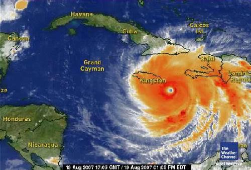
Power FM back up
stroom werd preventief uitgeschakeld in Jamaica zoals ook al aangekondigd.
misschien werken ze nu met een generator.
stroom werd preventief uitgeschakeld in Jamaica zoals ook al aangekondigd.
misschien werken ze nu met een generator.
Dostojewski: "Je kunt je niet van je eigen gezond verstand overtuigen door je buurman op te sluiten."
Nee hoor.quote:Op zondag 19 augustus 2007 19:45 schreef Caesu het volgende:
Jamaica Power FM is eruit geknald?
woef
Djeez zeg.. je zal dat ding voor je kiezen krijgen.
Lijkt me niet heel fijn, eerlijk gezegd
Lijkt me niet heel fijn, eerlijk gezegd
[b]Hobbelicious is back!
[/b]
[/b]
ja, hij deed het al snel weer.quote:
maar kwaliteit wordt steeds slechter.
[ploing]quote:Op zondag 19 augustus 2007 20:26 schreef MissHobje het volgende:
Djeez zeg.. je zal dat ding voor je kiezen krijgen.
Lijkt me niet heel fijn, eerlijk gezegd
idd
oog komt recht op Kingston af!

radar Cuba
GOES Satelite
Dostojewski: "Je kunt je niet van je eigen gezond verstand overtuigen door je buurman op te sluiten."
dubbel
Dostojewski: "Je kunt je niet van je eigen gezond verstand overtuigen door je buurman op te sluiten."
Pling wat een ellende !
Hoeeel slachtoffers zal het gaan kosten.. ik hoop geen..
En al die puinhopen pff.. gaat niet leuk worden dit.
Hoeeel slachtoffers zal het gaan kosten.. ik hoop geen..
En al die puinhopen pff.. gaat niet leuk worden dit.
[b]Hobbelicious is back!
[/b]
[/b]

Geen hoop ik inderdaad... dat word de komende dagen ff duimen..quote:Op zondag 19 augustus 2007 20:53 schreef MissHobje het volgende:
Pling wat een ellende !
Hoeeel slachtoffers zal het gaan kosten.. ik hoop geen..
En al die puinhopen pff.. gaat niet leuk worden dit.
D200|D50|50 1.8|18-55|70-300|SB600

Tering .quote:Op zondag 19 augustus 2007 20:49 schreef Caesu het volgende:
idd
oog komt recht op Kingston af!
[afbeelding]
radar Cuba
GOES Satelite
Waarom is er hier zo weinig aandacht voor op CNN? Ik had gehoopt van die hurricane watchers die midden in de storm staan enzo, net als vorig jaar bij een aantal hurricanes in amerika.
Overigens hoop ik natuurlijk ook op zo min mogelijk slachtoffers en schade, maar ik vrees dat het wel heftig wordt daar.
Overigens hoop ik natuurlijk ook op zo min mogelijk slachtoffers en schade, maar ik vrees dat het wel heftig wordt daar.
Mooi oranje is niet lelijk!
hij is nog niet in de USA.... zal toch een reden zijn. Heb nu BBC1 aanstaan, eens kijken of zij wat nieuws hebben.quote:Op zondag 19 augustus 2007 22:42 schreef rgn het volgende:
Waarom is er hier zo weinig aandacht voor op CNN? Ik had gehoopt van die hurricane watchers die midden in de storm staan enzo, net als vorig jaar bij een aantal hurricanes in amerika.
Overigens hoop ik natuurlijk ook op zo min mogelijk slachtoffers en schade, maar ik vrees dat het wel heftig wordt daar.
[b]Op maandag 6 september 2010 00:28 schreef tong80 het volgende:[/b]
GVD Wat moet jij een trotse vader zijn :)
:P
GVD Wat moet jij een trotse vader zijn :)
:P
Erg vroeg in het seizoen voor zo'n monster
Ben een paar keer in september nog wel naar het caraibisch gebied geweest (w.o. Jamaica en Cancun) en nergens last van gehad. Het hotel in Jamaica waar ik gezeten heb (naast Hedonism II ) zal wel behoorlijk onder vuur komen te liggen ..
Wel waanzinnig mooie foto's trouwens vanuit de spaceshuttle
Ben een paar keer in september nog wel naar het caraibisch gebied geweest (w.o. Jamaica en Cancun) en nergens last van gehad. Het hotel in Jamaica waar ik gezeten heb (naast Hedonism II ) zal wel behoorlijk onder vuur komen te liggen ..
Wel waanzinnig mooie foto's trouwens vanuit de spaceshuttle
I can only please one person per day. Today is not your day. Tomorrow isn't looking too good either.
http://www.nhc.noaa.gov/text/refresh/MIATCPAT4+shtml/192044.shtml
quote:MAXIMUM SUSTAINED WINDS ARE NEAR 145 MPH...230 KM/HR...WITH HIGHER
GUSTS. DEAN IS A CATEGORY FOUR HURRICANE ON THE SAFFIR-SIMPSON
SCALE. FLUCTUATIONS IN INTENSITY ARE COMMON IN MAJOR HURRICANES AND
ARE POSSIBLE DURING THE NEXT 24 HOURS. DEAN HAS THE POTENTIAL TO
BECOME A CATEGORY FIVE HURRICANE IN THE NORTHWESTERN CARIBBEAN SEA
TOMORROW.
HURRICANE FORCE WINDS EXTEND OUTWARD UP TO 60 MILES...95 KM...FROM
THE CENTER...AND TROPICAL STORM FORCE WINDS EXTEND OUTWARD UP TO 205
MILES...335 KM.
niet erg verrassend nieuwsquote:Op zondag 19 augustus 2007 23:20 schreef Roel_Jewel het volgende:
BreakingNewsOn: The National Hurricane Center says hurricane-force winds are hitting Jamaica.
[b]Op maandag 6 september 2010 00:28 schreef tong80 het volgende:[/b]
GVD Wat moet jij een trotse vader zijn :)
:P
GVD Wat moet jij een trotse vader zijn :)
:P
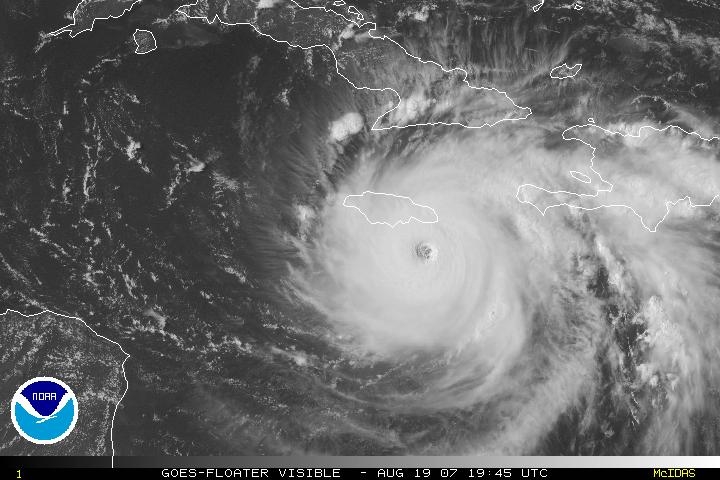

[ Bericht 33% gewijzigd door Caesu op 19-08-2007 23:53:58 ]
Dostojewski: "Je kunt je niet van je eigen gezond verstand overtuigen door je buurman op te sluiten."
En dan te bedenken dat het KNMI hier al een weeralarm afgeeft bij windkracht 6quote:
Bona valetudo melior est quam maximae divitiae
denk dat dat juist erger is in het oog is het mooi weerquote:Op maandag 20 augustus 2007 01:14 schreef Light het volgende:
[..]
Het oog lijkt net ten zuiden van Jamaica langs te trekken... scheelt vast in de schade
Ja, in het oog is het mooi weer, maar dan heb je wel twee keer de eye wall. En ik hoorde op CNN dat die juist voor extreem veel schade zorgt. Ook wel logisch ergens, de windsnelheid neemt eerst af van ca. 240 km/u naar (bijna) 0, en gaat daarna net zo hard weer terug.quote:Op maandag 20 augustus 2007 01:17 schreef hondenfokker het volgende:
[..]
denk dat dat juist erger is in het oog is het mooi weer
Jamaica lijkt er 'goed' vanaf te komen. Naast de materiele schade en de zware overstromingen, geen menselijke slachtoffers.
dat zou erg mooi zijn.quote:Op maandag 20 augustus 2007 08:14 schreef Frutsel het volgende:
Jamaica lijkt er 'goed' vanaf te komen. Naast de materiele schade en de zware overstromingen, geen menselijke slachtoffers.
[b]Op maandag 6 september 2010 00:28 schreef tong80 het volgende:[/b]
GVD Wat moet jij een trotse vader zijn :)
:P
GVD Wat moet jij een trotse vader zijn :)
:P
Ze zijn dus eigenlijk tegelijkertijd wel en niet door het oog van de naald gekropen .quote:Op maandag 20 augustus 2007 01:14 schreef Light het volgende:
[..]
Het oog lijkt net ten zuiden van Jamaica langs te trekken... scheelt vast in de schade
Nederlandse toeristen Mexico waarschijnlijk veilig (Nu.nl)
RIJSWIJK - De honderden Nederlandse toeristen die vakantie vieren in de Mexicaanse badplaatsen Playa del Carmen en Cancún, zullen waarschijnlijk weinig overlast ondervinden van de naderende orkaan Dean.
Als de orkaan de huidige koers voortzet, vallen de toeristische trekpleisters volgens reisorganisatie TUI Nederland buiten het bereik van Dean.
TUI heeft 650 gasten in de twee strandbestemmingen op het Mexicaanse schiereiland Yucatán. Op basis van de huidige voorspellingen zal de orkaan ongeveer 100 kilometer ten zuiden van Playa del Carmen en 150 kilometer ten zuiden van Cancún de kust bereiken.
"De plaatsen zouden daarmee buiten het bereik van de orkaan vallen", aldus een woordvoerster maandag. Naar verwachting bereikt Dean in de nacht van maandag op dinsdag rond 03.00 uur lokale tijd Mexico.
Voorzorg
Volgens TUI zijn er, bij wijze van voorzorg, dan ook nog geen toeristen overgebracht naar orkaanbestendige gebouwen. Mocht de orkaan van koers veranderen, dan kunnen de lokale autoriteiten daar echter alsnog toe over gaan.
Wel onderhoudt TUI via de reisleiding contact met alle Nederlandse toeristen. Ook heeft de organisatie extra medewerkers naar Cancún gestuurd die de plaatselijke reisleiding ondersteunen.
Montego Bay
Het oog van de orkaan trok in de nacht van zondag op maandag vlak langs de zuidkust van Jamaica waar tweehonderd Nederlanders verblijven. Ze zitten voornamelijk in de plaatsen Montego Bay en Ocho Rios in het noorden en Negrill in het noordwesten.
Volgens TUI zijn vrijwel alle accommodaties waar de toeristen verblijven, orkaanbestendig. Volgens de woordvoerster zijn slechts enkele reizigers naar andere hotels overgebracht.
De reisorganisatie heeft nog geen contact met Jamaica gehad. In verband met de orkaan hebben de Jamaicaanse autoriteiten als voorzorgsmaatregel de elektriciteit afgesloten.
Caymans Brace As Hurricane Dean Nears
Authorities in the Cayman Islands imposed a curfew and evacuated tourists as the British territory braced for a brush Monday with Hurricane Dean, which has left a trail of destruction across the Caribbean killing at least eight people.
Dean was expected to pass to the south of the Caymans but the government said it still posed a "significant threat" to the islands. Forecasters said the islands could receive up to 12 inches of rain.
Hundreds of frantic vacationers lined up at ticket counters for special flights home, and many slept on the airport floor. Cayman Islands Gov. Stuart Jack said all but 1,500 tourists had been evacuated from the British territory by Sunday afternoon.
"It's kind of spooky," said George Mitchell, of Detroit, who missed his flight out. "We don't know what to do or where to go. It freaks you out."
The National Hurricane Center in Miami said the first hurricane of the Atlantic season was a powerful Category 4 storm, and could reach the highest level Category 5, with maximum winds greater than 155 mph later Monday.
As of 5 a.m. EDT Monday, Dean was about 115 miles southeast of Grand Cayman and about 495 miles east of Belize City. It was traveling west at about 21 mph, the National Hurricane Center said.
In Mexico, travelers also slept on floors at Cancun's international airport, hoping to get one of the last flights out Monday before Dean was expected to slam into Mexico's Caribbean coast.
Nicolas Martignoles, 27, a teacher from Paris, stretched out on the airport floor with friends, prepared to wait all night. "We came to the airport because we are on standby, but all the flights are full, so we are waiting for another flight tomorrow."
Dean killed at least eight people as it moved across the Caribbean but Jamaica avoided a direct hit when the storm wound up passing to the south Sunday night. (ABC News)
Next named Storm, east of the Bahama's?
As if this weren't enough, there is a slowly developing system well east of the Bahamas that might be our next named storm. The NHC metions that slow development is possible as upper level winds become more favorable. The area forecast discussion from San Juan NWS tonight mentioned that it might indeed be our next storm or hurricane. Current computer models show what ever develops moving westward towards the Bahamas and Florida this week. It's that time of year and we could see quite a bit of activity coming up- be ready. (Hurricane Track)
As if this weren't enough, there is a slowly developing system well east of the Bahamas that might be our next named storm. The NHC metions that slow development is possible as upper level winds become more favorable. The area forecast discussion from San Juan NWS tonight mentioned that it might indeed be our next storm or hurricane. Current computer models show what ever develops moving westward towards the Bahamas and Florida this week. It's that time of year and we could see quite a bit of activity coming up- be ready. (Hurricane Track)
heeft iemand misschien meer informatie over die nieuwe storm bij de bahama's ?
ik ga woensdag namelijk naar punta cana in de dominicaanse republiek.
ik ga woensdag namelijk naar punta cana in de dominicaanse republiek.
De zwarte wolf komt eraan !
quote:Op maandag 20 augustus 2007 12:38 schreef Dentiwan het volgende:
heeft iemand misschien meer informatie over die nieuwe storm bij de bahama's ?
ik ga woensdag namelijk naar punta cana in de dominicaanse republiek.
Gaat om dat gebied rechts van de Bahama's ... geen idee hoe zich dat ontwikkeld en/of welke koers... dat blijft afwachten
hmm ziet er niet best uit... hopen dat we er niet al te veel last van krijgen.
De zwarte wolf komt eraan !
Black swans matter
Ik heb één keer in het oog gezeten.quote:Op maandag 20 augustus 2007 01:29 schreef Light het volgende:
[..]
Ja, in het oog is het mooi weer, maar dan heb je wel twee keer de eye wall. En ik hoorde op CNN dat die juist voor extreem veel schade zorgt. Ook wel logisch ergens, de windsnelheid neemt eerst af van ca. 240 km/u naar (bijna) 0, en gaat daarna net zo hard weer terug.
Dat was niet mooi weer ofzo, maar wel bijna windstil.
Het grappige is dat als dat ding overtrekt eerst de wind keihard de ene kant opgaat, daarna stilte, en daarna keihard de andere kant op.
"If you want to make God laugh, tell him about your plans"
Mijn reisverslagen
Mijn reisverslagen
Hoewel het centrum van orkaan 250km ten noorden van Aruba is vertrokken, werden de stranden geteisterd door enorme golven van soms 5 meter hoog.
Link
Rodgers Beach Aruba
Arubaanse noordkust
Met veel hogere golven dan normaal.
Onderstaande foto's gemaakt op Palm Beach, Aruba.
__
Link
Rodgers Beach Aruba
Arubaanse noordkust
Met veel hogere golven dan normaal.
Onderstaande foto's gemaakt op Palm Beach, Aruba.
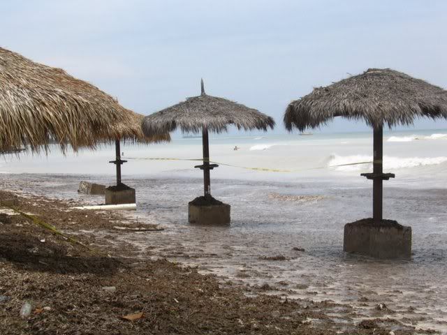
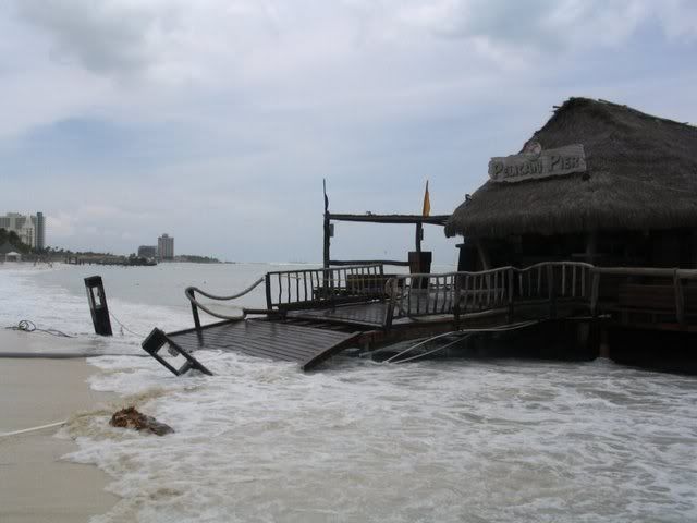


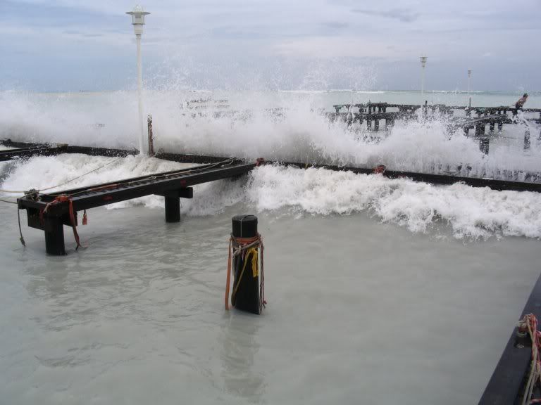
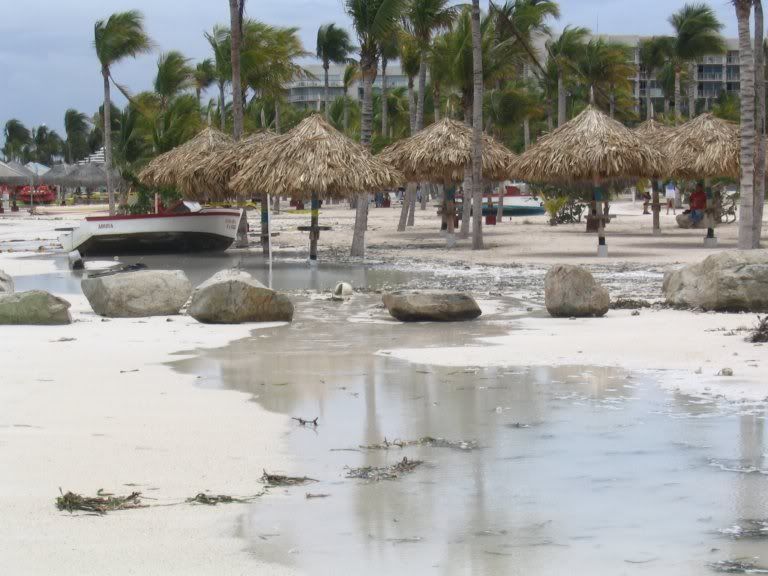
__

dat trekt daar erg snel naar het westen.quote:Op maandag 20 augustus 2007 12:38 schreef Dentiwan het volgende:
heeft iemand misschien meer informatie over die nieuwe storm bij de bahama's ?
ik ga woensdag namelijk naar punta cana in de dominicaanse republiek.
krijgt dan te weinig tijd boven warm water om te ontwikkelen.
kan als een stormpje aan land komen in Florida/S-Carolina.
als hij (Felix) langzamer gaat of zuidelijker kan het wel een hurricane worden.


Dostojewski: "Je kunt je niet van je eigen gezond verstand overtuigen door je buurman op te sluiten."
deze video kwam ik vandaag nog tegen en mooie beelden vanuit de ruimte
On-orbit Video Hurricane Dean
http://megavideo.com/?v=E1EBS1FD
On-orbit Video Hurricane Dean
http://megavideo.com/?v=E1EBS1FD
TVP. Ik woon in zuid-Alabama. Zijn er hier mensen die er wat meer verstand van hebben en mij kunnen vertellen of er een kans is dat Dean van richting veranderd over de Golf van Mexico en richting Alabama komt?
Ik vind het stiekem wel spannend
Ik vind het stiekem wel spannend
Heel indrukwekkend
<a href="https://www.youtube.com/channel/UCPueUwKfPaGH7v48LZlltkg" rel="nofollow" target="_blank">WSDokkum Youtube</a>
dat is denk ik nu wel uit te sluiten.quote:Op maandag 20 augustus 2007 19:09 schreef Lightning_NL het volgende:
TVP. Ik woon in zuid-Alabama. Zijn er hier mensen die er wat meer verstand van hebben en mij kunnen vertellen of er een kans is dat Dean van richting veranderd over de Golf van Mexico en richting Alabama komt?
Ik vind het stiekem wel spannend

maar soms zit NHC er naast.
zoals bij Rita bijvoorbeeld:
http://www.nhc.noaa.gov/archive/2005/RITA_graphics.shtml
Dostojewski: "Je kunt je niet van je eigen gezond verstand overtuigen door je buurman op te sluiten."
http://news.bbc.co.uk/2/hi/americas/6955163.stm
http://www.telegraaf.nl/b(...)co_veilig.html?p=2,1 :quote:Daniel Brown, from the US National Hurricane Center (NHC), said the focus was now on other areas.
"It looks like the biggest threat is going to be for portions of northern Belize and the Yucatan Peninsula coast of Mexico," he said.
At 0800 EDT (1200 GMT) the storm was about 440 miles (710km) east of Belize City, in Belize, which borders Mexico, and moving at nearly 21mph (33km/h).
The hurricane is heading west and is expected to move slightly north-westwards across the Yucatan Peninsula, the NHC said.
After crossing the Yucatan, the storm is forecast to move over the Bay of Campeche in the south-west Gulf of Mexico, before striking Mexico's coast again near Tampico.
Volgens mij spreken beide artikelen elkaar 'enigszins' tegen .......quote:Nederlandse toeristen Mexico veilig
De honderden Nederlandse toeristen die vakantie vieren in de Mexicaanse badplaatsen Playa del Carmen en Cancún zullen waarschijnlijk weinig overlast ondervinden van de naderende orkaan Dean. Als de orkaan de huidige koers voortzet, vallen de toeristische trekpleisters volgens reisorganisatie TUI Nederland buiten het bereik van Dean.
Op basis van de huidige voorspellingen zal de orkaan ongeveer 150 kilometer ten zuiden van Playa del Carmen en 200 kilometer ten zuiden van Cancún de kust bereiken. „De plaatsen zouden daarmee buiten het bereik van de orkaan vallen”, aldus een woordvoerster maandag. Naar verwachting bereikt Dean in de nacht van maandag op dinsdag rond 04.00 uur lokale tijd Mexico. In Nederland is het dan 11.00 uur 's ochtends.
Playa del Carmen en Canún zullen in ieder geval te maken krijgen met hevige regenval en hoge windsnelheden, maar bij de huidige koers niet met winden van orkaansnelheid.
Gaaf .quote:Op maandag 20 augustus 2007 18:39 schreef space2 het volgende:
deze video kwam ik vandaag nog tegen en mooie beelden vanuit de ruimte
On-orbit Video Hurricane Dean
http://megavideo.com/?v=E1EBS1FD
quote:Op maandag 20 augustus 2007 21:43 schreef Roel_Jewel het volgende:
http://news.bbc.co.uk/2/hi/americas/6955163.stm
[..]
http://www.telegraaf.nl/b(...)co_veilig.html?p=2,1 :
[..]
Volgens mij spreken beide artikelen elkaar 'enigszins' tegen .......

waarschijnlijk komt Dean ergens bij Chetumal aan land.
dus minder overlast voor Cancun.
en bijna alle gebouwen daar en zeker de hotels zijn van beton dus die blijven wel staan.
schade zal er vast wel zijn.
ze hebben al verkeerslichten en andere palen etc. neergehaald om te voorkomen die die ergens tegen aan neerstorten.
in Yucatan bereiden ze zich er altijd goed op voor.
als Dean woensdag voor de tweede keer aan land komt bij Tampico kan het erger uitpakken want deze havenstad ligt dichter aan de kust dan Chetumal.
ook veel industrie daar bij Tampico, het is een belangrijke oliehaven.
ligt er natuurlijk ook aan in hoeverre Dean weer aansterkt in de Baai van Campeche.
Dostojewski: "Je kunt je niet van je eigen gezond verstand overtuigen door je buurman op te sluiten."
Radar Cancun
http://smn.cna.gob.mx/radares/rad-canc.jpg (overbelast)
GOES Satellite
http://www.ssd.noaa.gov/goes/flt/t1/loop-vis.html

http://smn.cna.gob.mx/radares/rad-canc.jpg (overbelast)
GOES Satellite

http://www.ssd.noaa.gov/goes/flt/t1/loop-vis.html
Dostojewski: "Je kunt je niet van je eigen gezond verstand overtuigen door je buurman op te sluiten."
Mag die hierna NL ook wel even bezoeken , ik zal em met liefde verwelkomen
<a href="https://www.youtube.com/channel/UCPueUwKfPaGH7v48LZlltkg" rel="nofollow" target="_blank">WSDokkum Youtube</a>
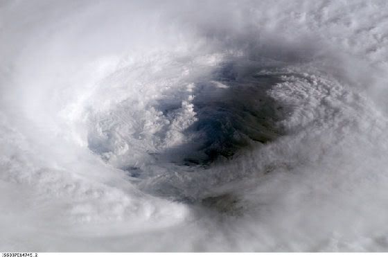
Moet je d'r eens eentje vinden met een 'open' oog, het stadium effect noemen ze dat geloof ik. Ik ga effe op zoek.
Als ik goed onthouden heb wat ik vanmorgen heb gehoord dan waren er "hurricane force winds" tot op 95 km van het oog, en "tropical storm force winds" tot op 300 km. Die 300 km weet ik niet meer zeker, maar tropical storm force winds noemen we hier gewoon windkracht 8. Niet echt strandweer meer dusquote:Op maandag 20 augustus 2007 13:47 schreef Stratos het volgende:
Hoewel het centrum van orkaan 250km ten noorden van Aruba is vertrokken, werden de stranden geteisterd door enorme golven van soms 5 meter hoog.
Stormvloed in goed ABN.quote:Op dinsdag 21 augustus 2007 02:42 schreef Frutsel het volgende:
stormsurge van 6 meter
NHC gaat uit van gemiddeld 260 km/h, stoten ver daarboven. Denk aan ruim 320!
Echter, geven ze aan dat dit een conservatieve indicatie is! De kans is groot dat de wind sterker is dan dit.
Echter, geven ze aan dat dit een conservatieve indicatie is! De kans is groot dat de wind sterker is dan dit.
Ik HAAT mijn toetsenbord.

oog staat op het punt om aan land te komen (satelliet-beeld van kwartier geleden)
er is al schade gemeld op San Pedro, een klein eilandje voor de kust van Belize.
bulletin 8:00:
extra bulletin 8:25:quote:MAXIMUM SUSTAINED WINDS ARE NEAR 160 MPH...260 KM/HR...WITH HIGHER
GUSTS. DEAN IS A POTENTIALLY CATASTROPHIC CATEGORY FIVE HURRICANE
ON THE SAFFIR-SIMPSON HURRICANE SCALE. LITTLE CHANGE IN STRENGTH
IS EXPECTED PRIOR TO LANDFALL. ALTHOUGH SOME WEAKENING IS FORECAST
AS DEAN CROSSES THE YUCATAN PENINSULA...DEAN IS EXPECTED TO
MAINTAIN HURRICANE STRENGTH THROUGHOUT THE NEXT 24 HOURS.
HURRICANE FORCE WINDS EXTEND OUTWARD UP TO 60 MILES...95 KM...FROM
THE CENTER...AND TROPICAL STORM FORCE WINDS EXTEND OUTWARD UP TO 175
MILES...280 KM.
THE MINIMUM CENTRAL PRESSURE ESTIMATED FROM THE AIRCRAFT DATA IS
911 MB...26.90 INCHES.
lagere luchtdruk dus.quote:DROPSONDE DATA FROM THE AIR FORCE RESERVE HURRICANE HUNTER AIRCRAFT
INDICATE THAT THE MINIMUM CENTRAL PRESSURE IN THE EYE OF HURRICANE
DEAN IS NOW 909 MB...26.84 INCHES.
dus windsnelheid zal ook hoger zijn zo vlak voor het aan land komen.
Dostojewski: "Je kunt je niet van je eigen gezond verstand overtuigen door je buurman op te sluiten."
The Weather Radio Broadcast Network geeft Love FM - radiozender Belize door.
voornamelijk Engels maar ook Spaanstalig.
http://www.wrbn.net:9462/listen.pls
voornamelijk Engels maar ook Spaanstalig.
http://www.wrbn.net:9462/listen.pls
Dostojewski: "Je kunt je niet van je eigen gezond verstand overtuigen door je buurman op te sluiten."
Een vliegtuig van NOAA vliegt op dit moment dor de orkaan. Dit is te volgen via google earth (zoek op google naar hurricane recon lankamp, de xml link opent in google earth). Op vliegniveau zit het nu rond 170 knopen. Dat wil zeggen: ongever 270 km/h gemiddeld aan de grond!
Ik HAAT mijn toetsenbord.
.quote:Op dinsdag 21 augustus 2007 08:35 schreef Caesu het volgende:
[afbeelding]
oog staat op het punt om aan land te komen (satelliet-beeld van kwartier geleden)
er is al schade gemeld op San Pedro, een klein eilandje voor de kust van Belize.
bulletin 8:00:
[..]
extra bulletin 8:25:
[..]
lagere luchtdruk dus.
dus windsnelheid zal ook hoger zijn zo vlak voor het aan land komen.
Ben benieuwd wat er overblijft daar ....
quote:I was the person that discovered the HF mechanism for the formation of this high altitude global warming blanket. One of the problems is this blanket is disrupted over the polar regions by the Van Allen radiation effects stirring the air, which goes to accelerate the polar ice melt rates.
This discovery set of a panic in the national lab systems and the US Government due to the projected harm effects due to the strength of storm problems, greater rates of earthquakes, more severe tropical storms, more volcanic activity, and etc.
http://members.aol.com/doewatch/chemtrails.html
We must guard against the aquisition of unwarranted influence, whether sought or unsought, by the military-industrial complex.
We must never let the weight of this combination endanger our liberties or democratic processes.
Eisenhower1961.
We must never let the weight of this combination endanger our liberties or democratic processes.
Eisenhower1961.

oog komt nu aan land. satelliet beeld van 8 minuten oud.
Dostojewski: "Je kunt je niet van je eigen gezond verstand overtuigen door je buurman op te sluiten."
Op CNN hadden ze 't net over landfall over ongeveer 2 a 3 uur. Vraag me af wat ze bedoelen met "landfall", is dan het oog bij 't land? of de gehele storm? of euh?quote:Op dinsdag 21 augustus 2007 09:34 schreef Caesu het volgende:
[afbeelding]
oog komt nu aan land. satelliet beeld van 8 minuten oud.
Verder is er nu eindelijk ook op CNN veel te horen over deze orkaan, was de afgelopen dagen niet echt zo. Er staan weer her en der verslaggevers in de storm, dus dat wordt een paar uurtje mooie televisie straks
Mooi oranje is niet lelijk!
Op dit moment ligt het oog precies boven Banco chinchorro, een koraalrif, naast puerto costa maya.
Ik HAAT mijn toetsenbord.
10 min. geleden.
http://weather.msfc.nasa.gov/cgi-bin/post-goes (zet op quality 100% en klik-zoom op het oog)

http://weather.msfc.nasa.gov/cgi-bin/post-goes (zet op quality 100% en klik-zoom op het oog)
Dostojewski: "Je kunt je niet van je eigen gezond verstand overtuigen door je buurman op te sluiten."
dit is de eerste keer na Andrew 1992 dat een hurricane met CAT5 direct aan land komt.
top 10 Hurricanes
1 Wilma 882 mbar (hPa)
2 Gilbert 888 mbar (hPa)
3 "Labor Day" 892 mbar (hPa)
4 Rita 895 mbar (hPa)
5 Allen 899 mbar (hPa)
6 Katrina 902 mbar (hPa)
7 Camille 905 mbar (hPa)
8 Mitch 905 mbar (hPa)
9 Dean 909 mbar (hPa) misschien maar 903 mbar
10 Ivan 910 mbar (hPa)
huilende en biddende mensen op Love FM Belize.
daarnet was er een hoogzwangere vrouw die naar het ziekenhuis moest in Belize City en vroeg om assistentie.
http://www.wrbn.net:9462/listen.pls
BBC World Service belde net de radiozender op.
[ Bericht 14% gewijzigd door Caesu op 21-08-2007 10:30:01 ]
Dostojewski: "Je kunt je niet van je eigen gezond verstand overtuigen door je buurman op te sluiten."
Geen metingen van de omgeving meer. Is geevacueerd en de stroom is uit voorzorg uit.
Ik HAAT mijn toetsenbord.
Storm DEAN: Observed By Air Force #303
Storm #04 in Atlantic Ocean
Maximum Flight Level Winds Were 162KT (186.3mph 300.0km/h) In NW Quadrant At 2358Z
Estimated Max Surface Winds 145.8KT (167.7mph 270.0km/h) * Misc Remarks:
Date/Time of Recon Report: NaN (NaN)
Position of the center: 18° 17' N 085° 00' W (18.3°N 85.0°W) [See Map]
Minimum Height Measured At Standard Level Of 700mb: 2359m (Normal: 3011)
Surface Winds Were Estimated At: 121KT (139.15MPH 224.1km/h)
Estimated Surface Winds Were Measured 9nm (10.35miles) From Center At Bearing 318°
Maximum Flight Level Winds Near Center Were 156KT (179.4mph 288.9km/h) From 047°
Maximum Flight Level Winds Were Measured 8nm (9.2 miles) From Center At Bearing 318°
Minimum pressure: 914mb (26.99in)
Eye Wall Was Characterized As Being: CLOSED WALL
Eye Form Was Characterized As Being Circular , 16 nm (18.4 mi 29.6km) wide
Center Fix Established Using: Penetration Radar Wind Pressure Temperature
Center Fix Established At Level(s): 700mb
Navigational Accuracy Measured At 0.02nm
Meteorological Accuracy Measured At 2nm
* = Estimated Surface Winds are assumed 90% of Max Flight Level Winds
Ik HAAT mijn toetsenbord.
quote:Maximum sustained winds are near 165 mph...270 km/hr...with higher
gusts. Dean is a category five hurricane on the Saffir-Simpson
scale. Although some weakening is forecast as Dean crosses the
Yucatan Peninsula...Dean is expected to maintain hurricane strength
throughout the next 24 hours.
Hurricane force winds extend outward up to 60 miles...95 km...from
the center...and tropical storm force winds extend outward up to 175
miles...280 km.
The hurricane hunter plane reported a minimum central pressure of
906 mb...26.75 inches...just before landfall.
Storm surge flooding of 12 to 18 feet above normal tide levels along
with large and dangerous battering waves is possible near and to
the north of where Dean made landfall along the East Coast of the
Yucatan Peninsula.
Dean is expected to produce storm total rainfall of 5 to 10 inches
over The Isthmus of Tehuantepec and Yucatan Peninsula of Mexico...
Belize...Guatemala...and northern Honduras...with maximum amounts
of up to 20 inches. These rains could cause life-threatening flash
floods and mud slides.
SOME HISTORIC NOTES ARE IN ORDER HERE. THE 906 MB
CENTRAL PRESSURE IS THE NINTH LOWEST ON RECORD FOR AN ATLANTIC
BASIN HURRICANE...AND THE THIRD LOWEST AT LANDFALL BEHIND THE 1935
LABOR DAY HURRICANE IN THE FLORIDA KEYS AND HURRICANE GILBERT OF
1988 IN CANCUN MEXICO. DEAN IS ALSO THE FIRST CATEGORY FIVE
HURRICANE TO MAKE LANDFALL IN THE ATLANTIC BASIN SINCE ANDREW OF
1992.
Dostojewski: "Je kunt je niet van je eigen gezond verstand overtuigen door je buurman op te sluiten."
Beelden en verslag zijn natuurlijk ook live te volgen op http://www.cnn.com/video (klik op live video).
Op CNN is nu al een tijdje een live uitzending bezig, dus als je up-to-date wilt blijven kun je ook CNN kijken. Ze bellen elke keer met mensen in de buurt en zo af en toe komen er wat beelden voorbij.
Mooi oranje is niet lelijk!
zeker weer van die sensatie reporters die nu in de stromende regen en windstoten verslag staan te doen

Die link doet het nietquote:Op dinsdag 21 augustus 2007 09:51 schreef Caesu het volgende:
http://weather.msfc.nasa.gov/cgi-bin/post-goes (zet op quality 100% en klik-zoom op het oog)
Zie ook http://www.nhc.noaa.gov/text/refresh/MIATCPAT4+shtml/211145.shtml .quote:HURRICANE DEAN HAS BEEN DOWNGRADED TO A CATEGORY 3 STORM, THE NATIONAL HURRICANE CENTER REPORTS
Zoiets? http://www.hurricanecity.com/live1.htmquote:Op dinsdag 21 augustus 2007 14:41 schreef SolidArt het volgende:
Is er geen streaming feed ergens ter plekke?
Presidential elections in Jamaica have been delayed due to damage caused by hurricane Dean, according to the Associated Press.
Dan zie ik alsnog niets waar ik bijvoorbeeld de kwaliteit kan instellen.quote:Op dinsdag 21 augustus 2007 13:48 schreef mostardos het volgende:
[..]
haal "/cgi-bin/post-goes" weg en je ziet het wel.
haal die lijn weg, klik op het plaatje, klik op het middelste plaatje, en daar kan je dan dingen instellen, als je het op 100% hebt neergezet kun je op de kaart klikken en dan krijg je dat gebied.
zo hoop ik dat het iets duidelijker is.
zo hoop ik dat het iets duidelijker is.
A Mean Dean Takes Aim on Mexico's Yucatan
+ Larger view (750Kb)
Hurricane Dean, expected to become a Category Five storm with maximum sustained winds of at least 135 knots (155 miles per hour), steams through the western Caribbean on its way to a projected landfall in Mexico's Yucatan Peninsula. In this August 20 image from NASA's QuikScat satellite, white arrows showing wind direction are superimposed on color images of wind speed.
Image credit: NASA/JPL
Klik voor filmpje download
Tropical Storms, Typhoons, and Hurricanes from the 2007 Season
[ Bericht 7% gewijzigd door -CRASH- op 21-08-2007 17:30:40 ]
<a href="http://www.vwkweb.nl/" rel="nofollow" target="_blank">Vereniging voor weerkunde en klimatologie</a>
<a href="http://www.estofex.org/" rel="nofollow" target="_blank">ESTOFEX</a>
<a href="http://www.estofex.org/" rel="nofollow" target="_blank">ESTOFEX</a>
Dean weakens over Yucatan to Category 2 (CNN)
CHETUMAL, Mexico (CNN) -- Hurricane Dean, weakened to a Category 2 storm, sprinted across Mexico's Yucatan Peninsula on Tuesday, knocking down trees and flooding streets but not inflicting catastrophic damage.
Dean charged ashore before dawn as a monster Category 5 storm but rapidly lost strength as it traversed the peninsula and was downgraded to a Category 2 at 10 a.m. (11 a.m. ET).
Downed power lines and damaged buildings were reported in Mexico and northern Belize, but no casualties.
Streets were flooded outside a hotel in Chetumal, just south of where Dean's center made landfall around 4:30 a.m. (5:30 a.m. ET) with maximum sustained winds of 165 mph (266 kph), according to the National Hurricane Center.
Two hotel workers tried to clear a clogged street drain with a garden rake in an effort to relieve the flooded streets.
The storm's eye passed just south of the resort areas of Cozumel and Cancun, striking a rural and sparsely populated area near Chetumal, the capital of the Mexican state of Quintana Roo.
At 10 a.m. (11 a.m. ET), the weakened hurricane had maximum sustained winds of 105 mph (165 kph) and was 90 miles (150 km) west-northwest of Chetumal, according to the hurricane center. It was moving west at 20 mph (32 kph).
The storm is expected to lose more strength as it passes across the Yucatan, before re-emerging in the Gulf of Mexico. It is forecast to strengthen again and hit central Mexico Wednesday with winds around 100 mph (161 kph)
Electricity was out in Chetumal, where most of the 130,000 residents in the coastal city appeared to have heeded government warnings to seek shelter or evacuate. Watch Dean blow into Chetumal »
Telephones were working in Chetumal, and three radio stations were still broadcasting the location of the storm to residents early Tuesday, Quintana Roo Gov. Felix Arturo Gonzalez Canto told CNN's "American Morning."
"This information is very essential to the people of the area where the hurricane is hitting," Gonzalez Canto said. He said the reports give people "assurance of what's happening and also a lot of tranquillity."
Of the 20,000 tourists in Quintana Roo, about 13,000 had been evacuated as of Monday evening, said Rosario Ortiz Yeladaque, the state's secretary of government.
About 20,000 tourists remained in Cancun hotels. Security guards at the Gran Melia Hotel prevented guests and journalists from going outside into the storm by chaining and barricading exits, according to CNN's Jason Carroll.
Dean is so large -- about the size of Texas -- that its tropical winds and waves affected the entire Yucatan and neighboring Belize to the south.
Jeff Spiegel, owner of the Azul Resort in Amerbergris Caye, Belize, said it was "incredibly windy" and the ocean surge was "very, very high." Most of the docks and piers have been washed away on the western side of his narrow island, he said.
Douglas Podzun, owner of the Corozal Bay Inn, said he traveled outside early Tuesday to rescue a relative and witnessed some of the damage in the northern Belize town of Corozal.
"There are downed power lines, there's a lot of trees down, a lot of streets with roofing laying around that have been blown off of houses, and cars shaking," Podzun said. "[There's] nobody on the street at all, not even the police. The police said if anybody needs help they're on their own because they're not going out anymore."
The Mexican government deployed 4,000 troops Monday, and a state of emergency was declared in the state of Campeche, where residents were bracing for as much as 20 inches of rain in some places.
Mexican President Felipe Calderon, who was in Canada for a trilateral meeting with President Bush and Canadian Prime Minister Stephen Harper, cut short his visit and prepared to return home Tuesday to deal with the storm.
In anticipation of the storm, parts of Belize, including Belize City, were put under a curfew Monday night, and Prime Minister Said Musa froze prices of goods and services to prevent price gouging. People were being evacuated from low-lying, coastal and valley areas to hurricane shelters, the prime minister's office said.
Forecasters do not believe the storm presents a threat to the United States, although officials in Texas continued to make storm preparations just in case Dean's path takes an unexpected turn.
Along the northern Yucatan coast, winds were only expected to reach tropical-storm force, above 39 mph (63 kph).
Meanwhile, in Jamaica, residents cleaned up fallen trees and debris Monday as the island nation started to recover from its brush with Dean on Sunday. See I-Reports of what Dean has done across the Caribbean »
While electric service was still out and most stores were closed, the international airport in Montego Bay reopened Monday night, allowing tourists who had been caught in the storm to begin leaving.
Although parts of Jamaica were pounded with sustained winds of 114 mph (183 kph), the eye of the hurricane passed to the south of the island, sparing its 2.8 million residents from a direct hit. Two deaths were reported in Jamaica, and the storm caused property damage and triggered landslides in some rural areas.
Dean is being blamed for at least seven other deaths in its march across the Caribbean, including two fatalities in Haiti, two in both Martinique and Dominica, and one in St. Lucia.