WKN Weer, Klimaat en Natuurrampen
Lees alles over het onstuimige weer op onze planeet, volg orkanen en tornado's, zie hoe vulkanen uitbarsten en hoe Moeder Aarde beeft bij een aardbeving. Alles over de verwoestende kracht van onze planeet en tal van andere natuurverschijnselen.


Typhoon Usagi
Typhoon Usagi is forecast to strike Japan at about 08:00 GMT on 2 August. Data supplied by the US Navy and Air Force Joint Typhoon Warning Center suggest that the point of landfall will be near 31.8 N, 132.4 E. Usagi is expected to bring 1-minute maximum sustained winds to the region of around 212 km/h (132 mph). Wind gusts in the area may be considerably higher.
According to the Saffir-Simpson damage scale the potential property damage and flooding from a storm of Usagi's strength (category 4) at landfall includes:
Storm surge generally 4.0-5.5 metres (13-18 feet) above normal.
Curtainwall failures with some complete roof structure failures on small residences.
Shrubs, trees, and all signs are blown down.
Complete destruction of mobile homes.
Extensive damage to doors and windows.
Low-lying escape routes may be cut by rising water 3-5 hours before arrival of the centre of the storm.
Major damage to lower floors of structures near the shore.
Terrain lower than 3 metres (10 feet) above sea level may be flooded requiring massive evacuation of residential areas as far inland as 10 km (6 miles).
There is also the potential for flooding further inland due to heavy rain.

Taifoen Usagi maakt minstens acht doden in Japan
TOKIO 02/08 (BELGA) = Een krachtige wervelstorm is donderdag over het Japanse vasteland getrokken. Met windsnelheden tot 162 kilometer per uur raasde taifoen Usagi over het departement Miyazaki in de in het zuiden gelegen regio Kyushu. Minstens acht mensen raakten gewond. Ruim 200 vluchten en talrijke spoorverbindingen werden afgelast. Bijna tienduizend gezinnen zaten zonder stroom. Twee mannen raakten in Miyazaki gewond toen het dak van een huis afscheurde. De Japanse weerdienst waarschuwde mensen in het bijzonder voor aardverschuivingen. Usagi, de vijfde taifoen van het seizoen, beweegt zich momenteel met een snelheid van 30 kilometer per uur richting noordwesten naar de Japanse Zee. Volgens de berekeningen van meteorologen zou de wervelstorm dan kracht verliezen. Tegen vrijdagmorgen zal volgens de weerdiensten 400 millimeter regen in het zuiden van Japan neerstromen. (HOA)
http://www.knack.be/belga(...)5-article101833.html
Typhoon Usagi hits southern Japan
Usagi is the second major typhoon to hit Japan this season
Eighteen people were injured and thousands sought shelter as Typhoon Usagi struck Japan's southern island of Kyushu.
The typhoon made landfall late on Thursday, bringing winds of up to 180 km/h (110mph).
It cut power to thousands of homes and felled trees. Bullet trains from the main island, Honshu, were suspended.
Usagi is moving northwards, but it has weakened and meteorologists have now downgraded it to a tropical storm.
Television footage showed uprooted trees and flooded rivers. A number of flights were cancelled.
Among the injured was an 81-year-old woman in the southern prefecture of Kagoshima who was blown over and broke her thigh, a local official said.
A postman was injured after wind overturned his van, another official said. Two people were reportedly hurt in falls from roofs.
In the hardest-hit areas, families and the elderly took refuge in municipal shelters.
Usagi, which means rabbit in Japanese, is the second major storm to hit Japan this season.
In July, Typhoon Man-yi left three people dead when it struck Kyushu and neighbouring island Shikoku.
http://news.bbc.co.uk/1/hi/world/asia-pacific/6928931.stm

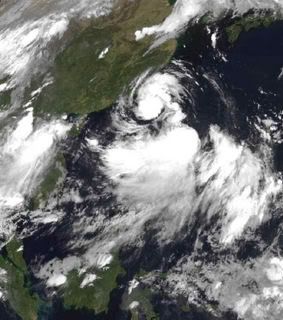
Typhoon Usagi
Just weeks after taking a beating from Typhoon Man-Yi in mid-July 2007, Japan’s southern islands were visited by Typhoon Usagi in early August. Although not as strong as Man-Yi, Usagi still forced the region to cancel air traffic and ferry services, and it left tens of thousand of homes without power, said news reports.
This image from the Moderate Resolution Imaging Spectroradiometer (MODIS) on NASA’s Terra satellite was captured on August 2, 2007, at 02:10 Universal Coordinated Time (11:10 a.m. local time in Japan). The northwest quadrant of Typhoon Usagi blankets Kyushu, Shikoku, and western Honshu with clouds. The outermost bands of clouds reach South Korea. The eye of the storm was about 55 kilometers (34 miles) off shore of southern Kyushu. Towering thunderstorms along the northern rim of the eye make it seem like the clouds are boiling.
Usagi was the fifth named storm of 2007 in the western Pacific. The storm reached Category 4 status, with maximum sustained winds of 120 knots (222 kilometers per hour, 138 miles per hour), but had weakened to Category 3 status, with winds of 100 knots (185 kilometers per hour, 115 miles per hour) about two hours before this image was captured.
Hallo,
Dit is mijn eerste post in dit forum/topic !
Er is vanacht een nieuwe storm ontstaan in de W.Pacific.
Dit zou weleens een zware storm kunnen worden voor Taiwan & China.
Pabuk is de naam van deze storm.
Dit is mijn eerste post in dit forum/topic !
Er is vanacht een nieuwe storm ontstaan in de W.Pacific.
Dit zou weleens een zware storm kunnen worden voor Taiwan & China.

Pabuk is de naam van deze storm.
Hurricane, Typhoon, Cycloon zijn welkom !
Gaat lekker
Waarom nou nooit eens NL stomme orkanen
Waarom nou nooit eens NL stomme orkanen
Doe mee met het voorspellen van het weer!
Weekvoorspelling | Week 12 (invullen tot 16-03 - 11:59)
Maandvoorspelling Maart (Inzendingen gesloten)
Jaarvoorspelling 2025 / 2026
Weekvoorspelling | Week 12 (invullen tot 16-03 - 11:59)
Maandvoorspelling Maart (Inzendingen gesloten)
Jaarvoorspelling 2025 / 2026

In de E.Pacific & W.Pacific is het seizoen tot nu toe behoorlijk lekker.
Maar in de Atlantische Oceaan is het nog niet veel. Maja hopelijk komt er nog wat vuurwerk.
Maar in de Atlantische Oceaan is het nog niet veel. Maja hopelijk komt er nog wat vuurwerk.
Hurricane, Typhoon, Cycloon zijn welkom !
Tropische storm eist levens in Vietnam (nieuws.nl)
(Novum/AP) - Een tropische storm met windsnelheden tot ruim zeventig kilometer per uur heeft in Vietnam negen slachtoffers geëist. Acht van hen verdronken door plotselinge overstromingen en een werd door een omvallende boom getroffen. Dat hebben de Vietnamese autoriteiten maandag gemeld.
Veertien mensen werden nog vermist. Tot de vermisten horen ook vijf leden van een familie, wier huis werd weggeslagen door een door de hevige regen aangezwollen rivier. In de provincie Daklak viel in vier dagen tijd 62 centimeter regen. Voor de komende dagen is nog meer regen voorspeld.
AUGUST BEGINS FAIRLY QUIET
The Atlantic Basin is still quiet as we make our way through the early part of August. There are a few tropical waves dotting the map but none look like they will develop over the next few days. Even though it is August, we really don't expect to see that dramatic upswing in activity until after the 15th. Between now and then, we might see a little activity pop up but it really is latter August, all of September and a good deal of October that we have to pay the most attention to. For most of you, this is nothing new. You know this. For those wondering where the hurricane season is- just wait a couple of more weeks and I believe we will see a marked increase in tropical storms. Who knows? Maybe we'll be fortunate enough to have very little to deal with again this season. There is no way to tell for sure, just be ready. I will have more here on Monday when I talk about our two newest sponsors of the site- and of course any goings on in the tropics. This weekend will be nice and quiet. (hurricanetrack)
The Atlantic Basin is still quiet as we make our way through the early part of August. There are a few tropical waves dotting the map but none look like they will develop over the next few days. Even though it is August, we really don't expect to see that dramatic upswing in activity until after the 15th. Between now and then, we might see a little activity pop up but it really is latter August, all of September and a good deal of October that we have to pay the most attention to. For most of you, this is nothing new. You know this. For those wondering where the hurricane season is- just wait a couple of more weeks and I believe we will see a marked increase in tropical storms. Who knows? Maybe we'll be fortunate enough to have very little to deal with again this season. There is no way to tell for sure, just be ready. I will have more here on Monday when I talk about our two newest sponsors of the site- and of course any goings on in the tropics. This weekend will be nice and quiet. (hurricanetrack)
yep, volgens de voorspellingen gaat Pabuk Taipei recht raken.... Heb inmiddels een storm waarschuwing per email doorgekregen. Momenteel is er een Red Alert warning voor Taipei = Red Alert (Severe) is CAT 1 or above to between 31% and 100% probability.
Volgens de lokale weerbureau is er momenteel een 45% kans op een Cat1+ hit in Taipei, en een 65% op een TS.
es kijken of ik vrij kan krijgen
Volgens de lokale weerbureau is er momenteel een 45% kans op een Cat1+ hit in Taipei, en een 65% op een TS.
es kijken of ik vrij kan krijgen
Totaal Travel 04-24: 87 reizen, 151 vliegtickets, 58 landen, 6 continenten, 949 reisdagen, 163.804 foto's
Mijn reisfotos!
Mijn reisfotos!
Taiwan word zo goed als zeker geraakt door Pabuk, de vraag is of het nog officieel gaat uitgroeien tot een typhoon. Momenteel is het nog een tropische storm. Verwachting is dat deze net groeit tot een typhoon als hij aan land gaat.
Pabuk is gedurende de nacht iets naar het zuiden gedraaid waardoor Taipei waarschijnlijk gemist gaat worden. Kans blijft aanwezig dat Taipei nog een flinke opzwieper krijgt, TSR schat 35% op typhoon kracht winden in Taipei, en 80% kans op tropische storm wind.
Regen is inmiddels losgebarsten nu de storm dichtbij is....
Over een uur de volgende update. Nog ~24 uur voordat de storm Taiwan gaat bereiken.......
Pabuk is gedurende de nacht iets naar het zuiden gedraaid waardoor Taipei waarschijnlijk gemist gaat worden. Kans blijft aanwezig dat Taipei nog een flinke opzwieper krijgt, TSR schat 35% op typhoon kracht winden in Taipei, en 80% kans op tropische storm wind.
Regen is inmiddels losgebarsten nu de storm dichtbij is....

Over een uur de volgende update. Nog ~24 uur voordat de storm Taiwan gaat bereiken.......
Totaal Travel 04-24: 87 reizen, 151 vliegtickets, 58 landen, 6 continenten, 949 reisdagen, 163.804 foto's
Mijn reisfotos!
Mijn reisfotos!
Hoewel dit volgens mij een typhoon wordt voor mietjuhs heb ik toch mijn fietstocht door de bergen van Taiwan nog even een paar dagen uitgesteld. Ik wou eigenlijk morgen vetrekken.
"If you want to make God laugh, tell him about your plans"
Mijn reisverslagen
Mijn reisverslagen
Tropical storm threatens Taiwan
regenkaart Tropical Depression 06W
In Vietnam valt de komende uren nog veel regenquote:No tropical development is expected in the Atlantic Basin over the next day or two.
In the eastern Pacific, an area of low pressure contains some limited convection over 875 miles southwest of Cabo San Lucas, Mexico. The system may slowly develop but is no threat to land.
Tropical Storm Pabuk (65 mph), currently located several hundred miles ESE of Taiwan. The storm is moving toward the WNW and is forecast to intensify to typhoon strength before striking Taiwan late Tuesday (U. S. time). Heavy rain and strong winds are likely in Taiwan as Pabuk sweeps in. Flooding rain may be a major problem. After crossing the island, Pabuk should weaken to a tropical storm and punch into mainland China on Wednesay (U. S. time).
A weak tropical depression is producing heavy rain over northern Vietnam and Laos.
regenkaart Tropical Depression 06W
Koers Typhoon PABUK voor 24 uur. Nu een categorie 1.
[ Bericht 7% gewijzigd door #ANONIEM op 07-08-2007 08:55:12 ]

[ Bericht 7% gewijzigd door #ANONIEM op 07-08-2007 08:55:12 ]

Nou het stelt voorlopig niks voor die typhoon.
Hier (Taipei) alleen een beetje motregen en nauwelijks wind.
Ik has net zo goed kunnen gaan fietsen.
Hier (Taipei) alleen een beetje motregen en nauwelijks wind.
Ik has net zo goed kunnen gaan fietsen.


"If you want to make God laugh, tell him about your plans"
Mijn reisverslagen
Mijn reisverslagen

weinig wind, weet je zeker dat je niet in het oog zit?quote:Op dinsdag 7 augustus 2007 10:30 schreef SeLang het volgende:
Nou het stelt voorlopig niks voor die typhoon.
Hier (Taipei) alleen een beetje motregen en nauwelijks wind.
Ik has net zo goed kunnen gaan fietsen.
[afbeelding]
[afbeelding]
[b]Op maandag 6 september 2010 00:28 schreef tong80 het volgende:[/b]
GVD Wat moet jij een trotse vader zijn :)
:P
GVD Wat moet jij een trotse vader zijn :)
:P
Dat heb ik serieus een keer meegemaakt een paar jaar geleden. Dat was echt weird; eerst waait het heel hard de ene kant op, dan is het een uurtje ofzo bijna windstil en daarna waait het keihard de andere kant op.quote:Op dinsdag 7 augustus 2007 10:37 schreef Againzender het volgende:
[..]
weinig wind, weet je zeker dat je niet in het oog zit?
"If you want to make God laugh, tell him about your plans"
Mijn reisverslagen
Mijn reisverslagen
Denk je dat je het hebt gehad, komt er nog een typhoon aan

"If you want to make God laugh, tell him about your plans"
Mijn reisverslagen
Mijn reisverslagen
Kan ik naar je toe komen, laat het gelijk een goeie zijn dan
Doe mee met het voorspellen van het weer!
Weekvoorspelling | Week 12 (invullen tot 16-03 - 11:59)
Maandvoorspelling Maart (Inzendingen gesloten)
Jaarvoorspelling 2025 / 2026
Weekvoorspelling | Week 12 (invullen tot 16-03 - 11:59)
Maandvoorspelling Maart (Inzendingen gesloten)
Jaarvoorspelling 2025 / 2026
kreeg idd weer een waarschuwingsmailtje van TSR, maar dit is een "kleintje" en volgens verwachtingen blijft het een tropische storm. Maar deze gaat wel recht over Taiwan. We zien welquote:Op woensdag 8 augustus 2007 07:21 schreef SeLang het volgende:
Denk je dat je het hebt gehad, komt er nog een typhoon aan
[afbeelding]
Van Pabuk weinig gemerkt behalve een flinke dosis regen, volgende keer beter
Totaal Travel 04-24: 87 reizen, 151 vliegtickets, 58 landen, 6 continenten, 949 reisdagen, 163.804 foto's
Mijn reisfotos!
Mijn reisfotos!
Doden door Tropische Stormen
Vietnam en de Filipijnen worden geteisterd door tropische stormen. In Vietnam zijn minstens 29 mensen om het leven gekomen door de hevigste storm van dit jaar tot dusver, meldden de autoriteiten woensdag.
Zij kwamen om door verdrinking als gevolg van plotselinge overstromingen of door bliksem. Verwacht wordt dat het dodental zal stijgen omdat twaalf mensen nog vermist worden en het nog steeds regent.
Op de Filipijnen veroorzaakte de tropische storm Pabuk aardverschuivingen die aan elf mensen het leven kostten. In het zuidelijk gelegen goudmijnstadje Maco werden maandag tien mensen onder het puin bedolven. Woensdagmorgen veroorzaakte Pabuk, samen met een nieuwe storm die ten noordoosten van de Filipijnen boven zee opstak, hevige regenval in het bergachtige noorden. Een 9-jarige jongen kwam daar eveneens bij een aardverschuiving om. Pabuk raasde later woensdag over de zuidelijke punt van Taiwan, waardoor drieduizend huishoudens zonder stroom kwamen te zitten.
http://www.nieuws.nl/473798
Pabuk made landfall on Tuesday as a minimial typhoon along the southern coast of Taiwan. It is now headed to mainland China near Hong Kong late tonight or early Wednesday (Eastern time). Pabuk is expected to continue to weaken.
Behind Pabuk is newly formed Tropical Storm Wutip. Wutip is headed near the same general path that Pabuk took ahead if it, towards the southern end of Taiwan and then onto mainland China. Wutip is currently not expected to become a typhoon.
In the Eastern Pacific, two clusters of storms--one roughly 1100 miles southwest of Cabo San Lucas, Mexico, the other near the coast of Puerto Vallarta, Mexico--have a slim chance to develop over the next few days.
The Atlantic basin remains quiet.
MORE MODELS SHOWING POTENTIAL DEVELOPMENT OFF OF AFRICA
I wrote earlier today about the GFS computer model and its insistence that we would see a tropical cyclone develop out near Africa in the coming days. Well, we can add the UKMET model from England (it too is a global model) and the Canadian model, though that model often develops storms that never develop. What I am looking for here is a trend and a concensus among more than just one model. That is starting to fall in to place and it will be interesting to see what indeed happens as we approach the weekend. In the longer term, my point of bringing this up is to make you aware that the most active part of the season may be just about to begin. I have heard a lot of talk about it being a quiet season and that it will be that way for the remainder. Well, we can only hope that's the case but the reality is likely to be different than what we hope. I believe we are about to see an increase in development potential and the next several weeks could be quite busy. As the cliche' goes "time will tell". I'll post another update tonight.
I wrote earlier today about the GFS computer model and its insistence that we would see a tropical cyclone develop out near Africa in the coming days. Well, we can add the UKMET model from England (it too is a global model) and the Canadian model, though that model often develops storms that never develop. What I am looking for here is a trend and a concensus among more than just one model. That is starting to fall in to place and it will be interesting to see what indeed happens as we approach the weekend. In the longer term, my point of bringing this up is to make you aware that the most active part of the season may be just about to begin. I have heard a lot of talk about it being a quiet season and that it will be that way for the remainder. Well, we can only hope that's the case but the reality is likely to be different than what we hope. I believe we are about to see an increase in development potential and the next several weeks could be quite busy. As the cliche' goes "time will tell". I'll post another update tonight.
Dodental tropische storm Vietnam loopt verder op
(Novum/AP) - Het dodental ten gevolge van een tropische storm die eerder deze week toesloeg in Centraal-Vietnam is tot zestig opgelopen. Negen mensen worden nog vermist. Aangenomen word dat ook zij zijn omgekomen. Meer dan honderdduizend mensen zijn dakloos geraakt. Dit hebben de autoriteiten vrijdag bekendgemaakt.
Het ging om de hevigste storm van dit jaar. De storm ging gepaard met overstromingen. De provincie Ha Tingh werd het zwaarst getroffen. Daar vielen 22 doden, onder wie acht kinderen.
http://www.nieuws.nl/474107
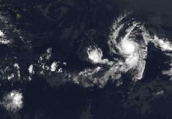
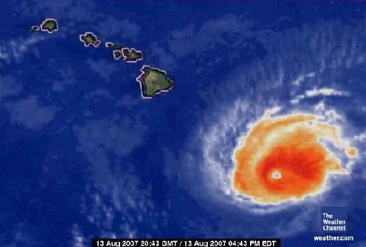
Orkaan Flossie zit nu op een categorie 3 en trekt in de richting van Hawaii.
On August 10, by 11:00 a.m. EDT, Tropical Storm Flossie strengthened into a hurricane in the eastern Pacific Ocean. Hurricane Flossie was headed west toward the big island of Hawaii.
Forecasters noted that satellite imagery indicated that Flossie was strengthening as an eye (center) became more apparent in infrared imagery from the Geostationary Operational Environmental Satellite (GOES). Flossie is located in the lower center of this image, which was taken August 10 at 10:52 a.m. EDT (7:52 a.m. PDT). Looking closely, there is a small dark spot in the middle of Flossie. That dark spot is the eye of the hurricane. The image was created by NASA's GOES Project Science Office at NASA's Goddard Space Flight Center, Greenbelt, Md.
On Friday, August 10 at 15:00 UTC (11:00 a.m. EDT), Flossie was located near 12.7 degrees north latitude and 136.0 west longitude. She was moving west at 12 knots (14 mph) and had a minimum central pressure of 987 millibars. Flossie was a Category 1 hurricane and was packing maximum sustained winds of 65 knots (74 mph) with gusts to 85 knots (97 mph).
The National Hurricane Center noted that slight strengthening is expected during the next 24 hours while Flossie remains over sea surface temperatures greater than 80 degrees Fahrenheit (F). Warm waters of around 80F are needed to continue to power and strengthen hurricanes.
Because sea surface temperatures along the westward forecast track cool, Flossie is expected to gradually weaken beyond 36 to 48 hours. That's good news, because Flossie is expected to pass to the south of the big island Tuesday night, August 14th. She is expected to bring rain and winds to the island as she passes. Image Credit: NOAA/NASA GOES Project; Storm summary: Rob Gutro (derived from NHS reports) Goddard Space Flight Center
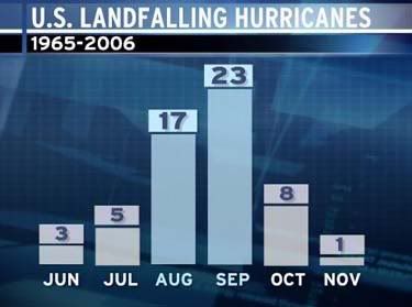
We constantly talk about the numbers of tropical storms and hurricanes that form in the Atlantic Basin through the course of hurricane season (June-November).
But perhaps we should look at a statistic that applies more directly to those of us living in the United States, namely U.S. hurricane landfall statistics. After all, you probably care far less about a hurricane that turns into the open north Atlantic than you do about one that is threatening or making landfall on your coastline.
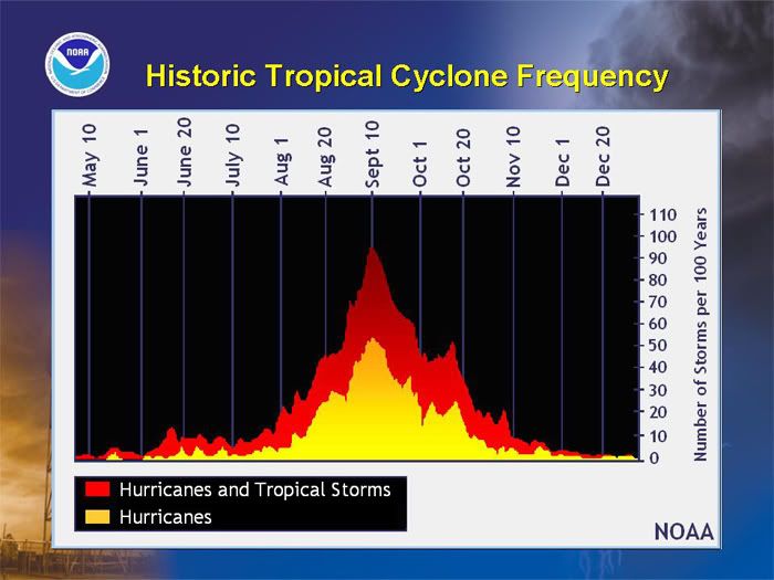
The chart below slows the number of U.S. hurricane landfalls per month since around the start of the satellite era (1965). It clearly indicates that most hurricanes (about 70% of them) hit the U.S. in August and September. October hits equal those of June and July combined.
Of particular interest is the fact that formation of Atlantic Basin tropical storms and hurricanes increases through August, peaks near September 10, then generally falls through the remainder of the season. Late August is historically much more active than early August across "the basin."
But if you count the number of U.S. hurricane landfalls the first 16 versus the last 15 days of August (since 1965) you will find that eight hurricanes hit in the first half of the month and nine, nearly the same number, hit in the second half of the month. This would indicate that a U.S. hurricane strike is nearly as likely in the first half as the second half of August based on this very reliable record.
So when we talk about the season "ramping up" through August, we are talking about the Atlantic Basin as a whole. Just remember for the U.S. coastline there is almost no "ramp up" in hurricane landfalls from the first to second half of August based on the most reliable hurricane record that includes the era of satellites.
bron:
But perhaps we should look at a statistic that applies more directly to those of us living in the United States, namely U.S. hurricane landfall statistics. After all, you probably care far less about a hurricane that turns into the open north Atlantic than you do about one that is threatening or making landfall on your coastline.
The chart below slows the number of U.S. hurricane landfalls per month since around the start of the satellite era (1965). It clearly indicates that most hurricanes (about 70% of them) hit the U.S. in August and September. October hits equal those of June and July combined.
Of particular interest is the fact that formation of Atlantic Basin tropical storms and hurricanes increases through August, peaks near September 10, then generally falls through the remainder of the season. Late August is historically much more active than early August across "the basin."
But if you count the number of U.S. hurricane landfalls the first 16 versus the last 15 days of August (since 1965) you will find that eight hurricanes hit in the first half of the month and nine, nearly the same number, hit in the second half of the month. This would indicate that a U.S. hurricane strike is nearly as likely in the first half as the second half of August based on this very reliable record.
So when we talk about the season "ramping up" through August, we are talking about the Atlantic Basin as a whole. Just remember for the U.S. coastline there is almost no "ramp up" in hurricane landfalls from the first to second half of August based on the most reliable hurricane record that includes the era of satellites.
bron:
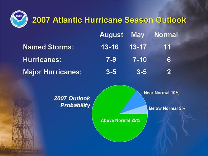
NOAA verwacht bovengemiddeld orkaanseizoen
Orkaandeskundigen van NOAA gaan nog steeds uit van een bovengemiddeld orkaanseizoen boven de Atlantische Oceaan. Een eerdere verwachting uit mei is vrijwel gelijk gebleven.
Nog steeds worden 13 tot 16 stormen verwacht, waaruit 3 tot 5 zware orkanen zullen ontstaan. De voorspellers zeggen dat de omstandigheden die waren verwacht, zijn uitgekomen. Het is alleen nu wachten op de eerste krachtige orkanen in het zeegebied.
Dat het nu rustig is op de Atlantische Oceaan is schijn. Tot nog toe zijn er van de 13 tot 16 systemen al drie ontstaan. Volgens de orkaandeskundigen is dat iets boven het gemiddelde. De orkaanactiviteit zal de komende weken sterk toenemen en pieken rond 10 september.
Ik verwacht daar niet veel van. Volgens mij wordt het voor de Atlantic zo'n seizoen als vorig jaar. De Pacific lijkt nu al wel druk.
Het is nog vroeg, maar Tropische Storm Sepat voorspellingen wijzen dat het een grote gaat worden. Voorlopig zal deze groeien tot een cat3 storm, ruim voordat Taiwan wordt bereikt. Voorspelling gaat niet verder in de toekomst, maar meeste typhoons groeien naar mate ze dichter bij land komen. Maar het is nog zeer vroeg, de storm zal Taiwan op zn vroegst over 5 dagen bereiken.quote:
(dat zou kut zijn omdat het dan net mn laatste weekend is in Taiwan )
Totaal Travel 04-24: 87 reizen, 151 vliegtickets, 58 landen, 6 continenten, 949 reisdagen, 163.804 foto's
Mijn reisfotos!
Mijn reisfotos!
Tropical Depression FOUR
Dit lijkt een flinke te worden. Verwachtingen gaan richting 90 KTS als windsnelheid, dat is 166km/h, met stoten tot 110 KTS, 203km/h.
Huidige positie; 800km ten zuidwesten van de Kaapverdische eilanden.
Bestemming: Zuidelijke Caribbean.
Dit lijkt een flinke te worden. Verwachtingen gaan richting 90 KTS als windsnelheid, dat is 166km/h, met stoten tot 110 KTS, 203km/h.
Huidige positie; 800km ten zuidwesten van de Kaapverdische eilanden.
Bestemming: Zuidelijke Caribbean.
/ ¦ ¦ / ¦ ¦

quote:Flossie A Strong Category 3 Storm
By AccuWeather.com Meteorologists Rob Miller and Alex Sosnowski Hurricane Flossie has weakened slightly to a Category 3 storm, with sustained winds of 125 mph . As of 11 a.m. HST Monday, the storm was around 425 miles southeast of Hilo, Hawaii. Hurricane Flossie was located near 15.3 north and 150.6 west and was moving to the west-northwest at 15 mph. The pressure of Flossie is 956 mb or 28.23 inches of mercury. Flossie is a relatively small storm with hurricane-force winds extending about 40 miles from the center and tropical storm-force winds extending 100 miles from the center. Flossie will likely slowly weaken during the balance of Monday and Tuesdayas it starts to encounter some cooler waters as it nears the Hawaiian Islands. The track of the storm has Flossie passing just south of the the Islands late Monday night into Tuesday. This will potentially bring heavy rainfall and gusty winds to the eastern and southern parts of the islands, as well as very rough surf. All interests in Hawaii should keep an eye on this storm as it continues to near the state. Elsewhere in the eastern Pacific Basin, a tropical wave is found near 98 west, mostly south of 17 north. This wave is moving westward at 15 knots. Another wave at 90 west is also moving westward at 15 knots. Satellite images Monday morning show several clusters of strong thunderstorms near these waves, but they remain disorganized at this time. Another tropical wave is found near 107 west and has an embedded 1012 mb (29.88 inches of mercury) low within this wave. This feature is moving west at 10-15 knots. While low pressure is present, this feature remains disorganized at this time. A final wave is found along 129 west, moving westward at 15 knots. Little to no convection is found with this wave.
Flossie Weakened, passes Hawaiian Islands
HONOLULU — Hurricane Flossie weakened to a Category 3 storm Monday with maximum sustained winds of 126 mph as it roared toward Hawaii, but it was expected to pass by the islands.
Forecasters earlier had said cooler weather would weaken the storm to a Category 1 hurricane, with sustained wind of at least 74 mph, by the time it passes about 70 miles south of the Big Island of Hawaii late Tuesday or early Wednesday.
But on Monday forecasters said they now expected a Category 3 hurricane, with little change in strength when it passes the island. Earlier in the day, Flossie had been a Category 4 storm with maximum sustained winds of 140 mph.
"The intensity has remained stronger than what was originally forecast, but the track has been pretty much right on," said Jim Weyman, the National Weather Service's meteorologist in charge in Honolulu.
The Central Pacific Hurricane Center said Flossie "remains a dangerous hurricane with a clear well-defined eye and good outflow. ... It must be noted that Flossie has been surprisingly resilient to cooler ocean temperatures so far."
Hurricane Off Hawaii Coast Upgraded to Category 4 The weather service placed the Big Island under a hurricane watch and a tropical storm warning. A flash flood watch was also issued for the island through Wednesday, with possible flash flooding in areas.
Mayor Harry Kim declared a state of emergency Monday as a precaution. All 56 public school on the Big Island also were closed for Tuesday.
The Big Island is largely rural, with about 150,000 people, and most live in the west or northeast, not the southern portion expected to be hit hardest by the hurricane. Other islands are expected to get much less of the storm's wind and rain.
At 5 p.m. EDT, Flossie was about 425 miles southeast of Hilo, the Central Pacific Hurricane Center said. It was moving west-northwest at about 15 mph.
Meteorologists cautioned that even a slight change of course in the unpredictable storm could take it closer to land.
Emergency workers had mobilized Sunday afternoon to prepare for the potentially devastating hurricane, the mayor said.
"You always prepare for the worst case scenario and hope for the best," Kim said.
Even though the eye of the storm may miss the Hawaiian Islands, Flossie could still bring strong wind and heavy rain, forecasters said.
Officials strongly urged residents statewide to prepare, including having a supply of food, water and disaster plans.
"If Flossie misses us, that's great. But we're still in hurricane season," said Ray Lovell, spokesman for the state Civil Defense Agency.
Parts of the Big Island, home to one of the world's most active volcanoes in Kilauea, likely will experience tropical storm-level winds and at least 10 to 15 inches of rain, Weyman said.
The south shore could see also see waves of 10 to 15 feet, forecasters said, with the surf rising starting late Monday. Waves along the east facing shores could increase to 8 to 12 feet on Tuesday. The island's South Point is the southernmost area of the United States.
The last time a hurricane hit Hawaii was in 1992, when Iniki ravaged Kauai, killing six people and causing $2.5 billion in damage.
Hurricane season runs from June 1 to Nov. 30. In May, forecasters said the Hawaiian Islands and the rest of the central Pacific faced a slightly below-average hurricane season, with just two or three tropical cyclones expected because of lower sea surface temperatures.
The islands get an average of 4.5 tropical cyclones a year; only about one every 15 years is powerful enough to be a hurricane. Last year, the central Pacific had five tropical cyclones after the National Oceanic and Atmospheric Administration predicted two to three.
On July 21, a tropical depression moved past the Big Island, bringing a few inches of rain to the parched island but no major problems. Cosme, the year's first Pacific tropical cyclone, reached hurricane status for a day before it weakened. (Foxnews)
FLOSSIE
[ Bericht 1% gewijzigd door Frutsel op 14-08-2007 10:34:11 ]
HONOLULU — Hurricane Flossie weakened to a Category 3 storm Monday with maximum sustained winds of 126 mph as it roared toward Hawaii, but it was expected to pass by the islands.
Forecasters earlier had said cooler weather would weaken the storm to a Category 1 hurricane, with sustained wind of at least 74 mph, by the time it passes about 70 miles south of the Big Island of Hawaii late Tuesday or early Wednesday.
But on Monday forecasters said they now expected a Category 3 hurricane, with little change in strength when it passes the island. Earlier in the day, Flossie had been a Category 4 storm with maximum sustained winds of 140 mph.
"The intensity has remained stronger than what was originally forecast, but the track has been pretty much right on," said Jim Weyman, the National Weather Service's meteorologist in charge in Honolulu.
The Central Pacific Hurricane Center said Flossie "remains a dangerous hurricane with a clear well-defined eye and good outflow. ... It must be noted that Flossie has been surprisingly resilient to cooler ocean temperatures so far."
Hurricane Off Hawaii Coast Upgraded to Category 4 The weather service placed the Big Island under a hurricane watch and a tropical storm warning. A flash flood watch was also issued for the island through Wednesday, with possible flash flooding in areas.
Mayor Harry Kim declared a state of emergency Monday as a precaution. All 56 public school on the Big Island also were closed for Tuesday.
The Big Island is largely rural, with about 150,000 people, and most live in the west or northeast, not the southern portion expected to be hit hardest by the hurricane. Other islands are expected to get much less of the storm's wind and rain.
At 5 p.m. EDT, Flossie was about 425 miles southeast of Hilo, the Central Pacific Hurricane Center said. It was moving west-northwest at about 15 mph.
Meteorologists cautioned that even a slight change of course in the unpredictable storm could take it closer to land.
Emergency workers had mobilized Sunday afternoon to prepare for the potentially devastating hurricane, the mayor said.
"You always prepare for the worst case scenario and hope for the best," Kim said.
Even though the eye of the storm may miss the Hawaiian Islands, Flossie could still bring strong wind and heavy rain, forecasters said.
Officials strongly urged residents statewide to prepare, including having a supply of food, water and disaster plans.
"If Flossie misses us, that's great. But we're still in hurricane season," said Ray Lovell, spokesman for the state Civil Defense Agency.
Parts of the Big Island, home to one of the world's most active volcanoes in Kilauea, likely will experience tropical storm-level winds and at least 10 to 15 inches of rain, Weyman said.
The south shore could see also see waves of 10 to 15 feet, forecasters said, with the surf rising starting late Monday. Waves along the east facing shores could increase to 8 to 12 feet on Tuesday. The island's South Point is the southernmost area of the United States.
The last time a hurricane hit Hawaii was in 1992, when Iniki ravaged Kauai, killing six people and causing $2.5 billion in damage.
Hurricane season runs from June 1 to Nov. 30. In May, forecasters said the Hawaiian Islands and the rest of the central Pacific faced a slightly below-average hurricane season, with just two or three tropical cyclones expected because of lower sea surface temperatures.
The islands get an average of 4.5 tropical cyclones a year; only about one every 15 years is powerful enough to be a hurricane. Last year, the central Pacific had five tropical cyclones after the National Oceanic and Atmospheric Administration predicted two to three.
On July 21, a tropical depression moved past the Big Island, bringing a few inches of rain to the parched island but no major problems. Cosme, the year's first Pacific tropical cyclone, reached hurricane status for a day before it weakened. (Foxnews)
FLOSSIE

[ Bericht 1% gewijzigd door Frutsel op 14-08-2007 10:34:11 ]
kwestie van tijd voor TD 4 DEAN zal worden....
MIAMI, Florida (AP) -- A tropical depression formed Monday in the far eastern Atlantic, the fourth of the Atlantic hurricane season, meteorologists said.
At 5 p.m. EDT, the depression was centered about 620 miles west-southwest of the southernmost Cape Verde Islands, and moving west near 20 mph, according to the National Hurricane Center. It was still about 1,900 miles east of the Lesser Antilles in the Caribbean.
Its maximum sustained wind speed was about 35 mph, forecasters said. It would be named Tropical Storm Dean if its sustained wind strengthens to at least 39 mph, the threshold for a named storm.
Hurricane forecasters expect this year's hurricane season to be busier than average. Last week, they said up to 16 tropical storms are likely to form, with nine of them becoming hurricanes.
The Atlantic hurricane season runs from June 1 to November 30, but August typically marks the start of the most active period. Last year, there were 10 tropical storms in the Atlantic and just two made landfall in the United States.
[ Bericht 55% gewijzigd door Frutsel op 14-08-2007 10:29:20 ]

misschien komt ie wel nergens aan land, dat ie zo verder naar het noorden met een boogje de oceaan op gaat.
verder nog een stormpje in de Golf van Mexico die op die grens Mexico/USA aan land komt.
Dostojewski: "Je kunt je niet van je eigen gezond verstand overtuigen door je buurman op te sluiten."
waarschuwings briefjes hangen alweer in de lobby, kans is kleind at ie hit, maar het belooft een flinke te worden.quote:Op dinsdag 14 augustus 2007 10:12 schreef Frutsel het volgende:
Sepan
[afbeelding]
Idd...mogelijk weer Taiwan
Totaal Travel 04-24: 87 reizen, 151 vliegtickets, 58 landen, 6 continenten, 949 reisdagen, 163.804 foto's
Mijn reisfotos!
Mijn reisfotos!
kan natuurlijk ook zijn dat ze die in de Golf van Mexico Dean noemen en die andere Erin.
want ze komen ongeveer tegelijkertijd op tropical storm-sterkte.
want ze komen ongeveer tegelijkertijd op tropical storm-sterkte.
Dostojewski: "Je kunt je niet van je eigen gezond verstand overtuigen door je buurman op te sluiten."
verrekquote:Op dinsdag 14 augustus 2007 10:18 schreef Caesu het volgende:
kan natuurlijk ook zijn dat ze die in de Golf van Mexico Dean noemen en die andere Erin.
want ze komen ongeveer tegelijkertijd op tropical storm-sterkte.
daar zit er ook eentje inderdaad
via Hurricanetrack.com
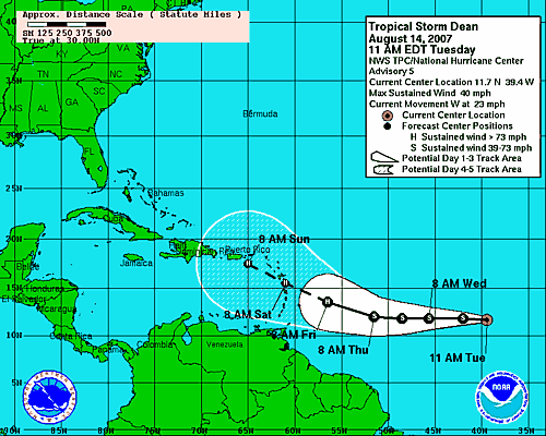
quote:UPDATED: 10:45 am EDT, August 14, 2007
NHC UPGRADES TD#4 TO TS DEAN
Just a quick note to update the fact that TD 4 is now TS Dean. The NHC made the upgrade just a little while ago. Forecast shows Dean becoming a strong hurricane as it passes through the NE Caribbean Sea in about five days. I have updated the tracking maps and will have a full update here later this afternoon, around 5pm ET.
UPDATED: 8:50 am EDT, August 14, 2007
GULF, ATLANTIC AND PACIFIC VERY ACTIVE THIS WEEK
There is now plenty of activity from the central Pacific to the Gulf of Mexico and out in to the east Atlantic. The quiet hurricane season we were enjoying has come to an abrupt end and this is really just the start.
Hurricane Flossie is weakening as it approaches Hawaii but the one time category four hurriane will still bring squally weather and rough seas. The forecast keeps Flossie just south of the string of islands so we don't expect too much of an impact. It could certainly be worse and we saw that back in 1992 when powerful hurricane Iniki lashed portions of the islands. This time around, it is just a close call and that is good news for anyone who lives in or is planning a trip to Hawaii.
Next up is our developing tropical depression in the Gulf of Mexico. Upper level winds are more favorable and it is quite possible that the NHC will upgrade the system to a depression later today. Most computer models develop this in to a tropical storm and move it towards Mexico and Texas. The biggest threat will be heavy rains but if it intensifies quickly enough, there could also be some wind and surge issues as well. The NHC is sending a Hurricane Hunter plane in to the area later today, if conditions continue to warrant, and we will know a lot more at that point.
Out in the east Atlantic is TD #4. It is holding its own and is in no hurry to strengthen right away. It is in a hurry in a literal sense though. The depression is moving very quickly towards the west at over 20 mph. The NHC forecasts the depression to become a tropical storm and then a hurricane as it nears the northern Leeward Islands. This could be quite an interesting situation for folks in the northeast Caribbean Sea as some computer models show the (at that point) hurricane passing through the islands while others miss to the north. It looks like what ever scenario that plays out will do so within about five days- so there is still time to just wait and see what happens. Beyond five days, we get little solid evidence of what the system will do. The key will be, as always, how strong the cyclone is and what the steering currents are like to its north. There is no need to even try to speculate this early as to where this might end up. We have a long, long time to watch and track its progress, which gives a great advantage of allowing us to be prepared, if need be. The rest of the tropics are mostly quiet but we are now in a period when we will likely see a new named storm on a regular basis somewhere in the Atlantic Basin. I will post another update here early this afternoon and again this evening.
* I intend to live forever, so far so good! *
Orkaan dreigt bij Antillen
AMSTERDAM - Metereologen vrezen dat tropische storm Dean zich richting de Antillen kan ontwikkelen tot de eerste orkaan van het seizoen. Ook bij Hawaii is groot alarm geslagen vanwege orkaan Flossie.
Waar Dean schade gaat aanrichten, is volgens CNN vooralsnog onduidelijk. Orkanen volgen vaak een onnavolgbaar spoor van vernieling. De laatste kaarten wijzen erop dat het centrum kan liggen bij de Dominicaanse republiek. De Nederlandse Antillen zouden volgens die zelfde voorspellingen aan de rand van de gevarenzone liggen
.De tropische storm volgt z'n weg richting de kust van Venezuela. Het slechte weer gaat met een snelheid van ruim dertig kilometer per uur naar de eilandengroep, zo meldt het National Hurricane Center in Miami. Voorlopig is de storm nog 1500 mijl verwijderd van de Antillen. De windsnelheid kan op gaan lopen naar 96 mijl per uur komend weekend. De storm kan zich verder ontwikkelen als het slecht weer gebied over warm water gaat.
Aan de andere kant van Amerika bij Hawaii zijn veel maatregelen genomen tegen de komende orkaan Flossie. De noodtoestand is uitgeroepen en windsnelheden zullen ook tot zo'n 150 kilometer per uur kunnen oplopen. De beroemde surfgolven zullen huizenhoog worden.
Orkaandeskundigen voorspellen dit jaar het drukste Hurricane-seizoen ooit op de Atlantische oceaan. Ze verwachten zestien tropische stormen, waarvan zich waarschijnlijk negen zullen ontwikkelen tot orkaankracht.
Het 'seizoen' loopt meestal van begin juni tot eind november, maar augustus begint het gerommel vaak pas goed.
De Telegraaf