WKN Weer, Klimaat en Natuurrampen
Lees alles over het onstuimige weer op onze planeet, volg orkanen en tornado's, zie hoe vulkanen uitbarsten en hoe Moeder Aarde beeft bij een aardbeving. Alles over de verwoestende kracht van onze planeet en tal van andere natuurverschijnselen.


Uit het niets opdoemende massa\'s zand...
"Wie ooit een zand- en stofstorm aan de horizon heeft zien verschijnen weet dat eens en voor altijd", was me verteld voordat ik vertrok naar een van de door droogte en hongersnood geteisterde Sahel-landen in West-Afrika. En inderdaad: zoiets vergeet je nooit. De onvoorstelbare stilte in de woestijn voor de storm, het stralende weer rondom, en dan – plotseling - aan de horizon een gigantische en ondoordringbaar lijkende muur van zand en stof. Veel tijd om te schuilen is er niet. Geen wonder dus dat de dreigend voortrollende wals van zand en stof woestijnreizigers doodsangst inboezemt. Alleen al bij het zien ervan komt het gevoel op verpletterd te worden of te verstikken. Zó compact is het stof, dat zelfs de felle woestijnzon er niet doorheen dringt.
Maar omdat dergelijke zand- en stofstormen meestal door dalende heteluchtmassa\'s worden veroorzaakt, kan de temperatuur evengoed ondraaglijk hoog oplopen. In dit geval tot 52oC. Tegelijkertijd zakte de luchtvochtigheid tot een paar procent. Als je als woestijnreiziger in een langdurige storm belandt, verkeer je ook in zeer groot levensgevaar. Het menselijk lichaam kan als gevolg van de uitdrogende werking van een zandstorm 1 liter vocht per uur verliezen. Als er geen drinkwater beschikbaar is om het vochtverlies aan te vullen, dan is de dood door uitdroging slechts een paar uur veraf. Er zijn lijken in de woestijn gevonden die volledig waren gemummificeerd doordat al het lichaamsvocht tijdens een zandstorm was verdampt.
Verkeer en Stofstormen
Maar misschien is dit wel het vreemdste gezicht: dat midden in de oranje-rode mist van stof auto\'s blijven voortploegen onder het voeren van groot licht. Natuurlijk: het zicht binnen een zware stofstorm is minder dan 200 meter. In het geval van een zeer zware stofstorm zelfs minder dan 50 meter. De meeste motoren in het woestijnverkeer zijn aangepast door speciale luchtfilters. Het vernietigende werk beperkt zich dus voornamelijk tot de buitenkant. Vooral als er sprake is van een echte zandstorm, met tot 2 meter hoogte opspringende zandkorrels, wordt alles langzaam maar zeker gezandstraald. Is de windsnelheid hoog, dan is binnen 48 uur alle lak van de carrosserieën geschuurd. Bovendien zijn de ruiten mat en ondoorzichtig, zodat ze verwijderd moeten worden om verder te kunnen rijden. Gelukkig is dat een uitzondering. De meeste stofstormen, waarbij fijn woestijnstof tot kilometers hoogte kan worden opgestuwd, hebben een doorsnede van 10 tot 20 kilometer en zijn vaak al na een half uur voorbij. Even plotseling als zij is verdwenen, breekt de zon door en beschijnt de achterkant van de stofmuur. Het is dan alsof je met een onderzeeër van onder een wateroppervlak opduikt.
Stofstorm in de Sahel, midden overdag.
Harmattan, Khamsin, Rood Stof?
Dit alles is een zand- en stofstorm op plaatselijke schaal. De fijnste stofdeeltjes blijven nog dagen- tot maandenlang in de atmosfeer zweven. De harmattan, die van de West-Afrikaanse Sahara in zuidelijke richting waait, voert het stof naar de landen aan de Golf van Guinee, waar het verder bijdraagt tot de voortgaande sahellisering. De khamsin, die vanuit Soedan en Egypte in noordwestelijke richting waait, transporteert jaarlijks 25 miljoen ton stof richting Israël. De sirocco, in noordelijke richting waaiend vanaf Algerije en Libië, voert stof tot aan de Alpen en beïnvloedt daar in sterke mate het afsmelten en terugtrekken van de gletsjers. Het rode stof valt op de gletsjers en vormt een dun laagje op het ijs. Daardoor wordt er minder zonlicht teruggekaatst en neemt het ijs meer warmte op.
In Italië veroorzaakt het rode stof - als het tijdens een bui uit de atmosfeer wordt gewassen - opmerkelijke ‘bloedregens’. Ook in Nederland, Engeland en zelfs in Zuid-Zweden komt van tijd tot tijd woestijnstof neer. Maar het record boekte een woestijnstorm uit 1970, die met de noordoostpassaat de gehele Atlantische Oceaan overstak. Dagenlang was toen het luchtverkeer van en naar de eilanden in het Caribische gebied door stof uit de Sahara gestremd. Ook begin 2005 waren de gevolgen van de stofstorm helemaal in Florida te merken.
Begin 2005 trok een gigantische stofstorm vanuit de Sahara over de Atlantische Oceaan. NASA’s Aqua-satelliet legde de gelige stofwolk van bijna 5300 km breedte vast met behulp van de MODIS (Moderate Imaging Resolution Spectroradiometer)
Komen ze overal voor?
Zand- en stofstormen komen natuurlijk niet alleen in de Sahara voor. Een derde deel van alle landoppervlak op aarde bestaat uit woestijnen en halfwoestijnen. Soortgelijke stormen steken dus ook regelmatig de kop op in de woestijnen van Australië, China en Zuid-Rusland, Zuid-Afrika en Zuid-Amerika, en zelfs in de Verenigde Staten. Dáár, in een gebied dat door de Amerikanen de ‘dust-bowl’ wordt genoemd (Kansas en Nebraska) én in de woestijnen in Nevada en Arizona, staan langs sommige autosnelwegen om de 8 km waarschuwingsborden met ‘Blowing dust, reduce speed’ (‘Snelheid verminderen: waaiend stof’).
De zand- en stofstormen in de ‘dustbowl’ hebben de Amerikanen overigens aan zichzelf te danken. In de jaren dertig van de vorige eeuw werd dit gebied door akkerbouw en voortdurend ploegen van de grond zodanig losgewoeld, dat de bodem steeds losser werd en de vruchtbare bovenlaag aan de wind was overgeleverd. Sinds die tijd trad ‘zelfverwoestijning’ op. Als eenmaal het beschermende vegetatiedek er af is, en de grond ligt open en bloot ten prooi aan verwering, dan droogt hij uit en verwaait. Er ontstaat een kuil waarin de wind gaat wervelen en het effect van een boor krijgt. De windkuil wordt steeds groter. Als er meer van dergelijke waaigaten zijn, dan transporteert de wind het geërodeerde materiaal in de vorm van zand en stof van de een naar de ander. Het zand heeft daarbij een schurende werking. Als zo\'n proces eenmaal op gang is gekomen, is het nauwelijks meer tegen te houden.
Stofstorm in Kansas (1935
Zandstormen
Een zandstorm is een harde, droge wind die over een woestijn raast en ervoor zorgt dat zand of stof opwaait. Hierdoor wordt het zicht drastisch belemmerd, soms bijna tot nul. Een dergelijke wind is gewoonlijk het resultaat van luchtstromen die door intense warmte van de grond worden veroorzaakt. Een zandstorm is sterk genoeg om duinen van plaats te doen veranderen.
Zandstorm nadert Al Asad, Irak, vlak voordat de avond valt op 27 April 2005
Simoom is de naam van de woestijnwind in Noord-Afrika en Arabië. Deze wind draagt voor een belangrijk deel bij tot het atmosferische stof in Europa. Haboob is de naam van de zandstormen in het gebied rond Khartoem in Soedan. Zandstormen kunnen ook in andere delen van de wereld voorkomen, bijvoorbeeld in de Verenigde Staten en Australië. Zandstormen komen ook vaak voor op de planeet Mars.
Satellietfoto zandstorm in Burkina Faso
SaharaStof
Saharastof is stof uit de Sahara dat met de regen op aarde terecht komt. Tijdens stof-en zandstormen, die in het woestijngebied voorkomen, kan het stof tot kilometers hoogte in de atmosfeer komen. Wanneer de luchtstroming over een enorme afstand van zuid naar noord is gericht, kan het saharastof zelfs tot boven Nederland en België of nog noordelijker komen. Valt er dan regen, dan kan het stof met de neerslag op het aardoppervlak terechtkomen. Vooral na een licht buitje vinden we het vaak roodbruin gekleurde saharastof terug op voorwerpen als auto\'s, daken en tuinmeubilair.
Saharastof bij de Canarische eilanden op 11-02-2001: NASA
Neerslag met saharastof is al een eeuwenoud verschijnsel. Vroeger kon men het alleen niet verklaren en werd het wel toegeschreven aan insecten die het regenwater roodachtig kleurden. Het stond ook wel bekend als bloedregen of wonderregen. In de landen rond de Middellandse Zee komt het herhaaldelijk voor. In Nederland is saharastof in de twintigste eeuw op zeker vijftien dagen op uitgebreide schaal voorgekomen, steeds bij voor de tijd van het jaar warm weer. Afhankelijk van het brongebied kan de kleur van het stof variëren van lichtgrijs tot rood of bruin. Het bevat verschillende mineralen en is soms al enkele dagen vóór het ons land bereikt op de satellietfoto te zien.
Stofstorm over de Arabische Zee op 10 februari 2007
Stofstorm boven de Perzische Golf op 17 februari 2007
Stofstorm in Libië op 23 februari 2007
Opmerkelijk was de situatie van 12 mei 1998. Door de hitte ontstonden heel lokaal enkele regen- en onweersbuien. De atmosfeer zat vol met stuifmeel afkomstig van bomen en bloeiende grassen en hoog in de atmosfeer zat ook wat stof uit de Sahara; het brongebied van de lucht die ons toen bereikte lag in de Sahara. Het saharastof kan hier en daar met de neerslag naar beneden zijn gekomen, maar de meeste verontreiniging die toen werd aangetroffen was stuifmeel.
Op 4 februari 2000 is op verscheidene plaatsen in Nederland fijn saharastof waargenomen. Onderzoek door de Klimatologische Dienst van het KNMI heeft uitgewezen dat het stof afkomstig was uit Mauritanië, waar op 31 januari een zandstorm woedde. Van daaruit is het boven de Atlantische Oceaan terechtgekomen tot een eind ten westen van Madeira. Vervolgens is het stof naar het noorden afgebogen om vervolgens via het zuiden van Engeland met een zuidwestelijke stroming in Nederland terecht te komen. Het komt zelden voor dat zand uit de Sahara zo\'n lange omweg aflegt, meestal komt het met zuidelijke winden vrijwel recht naar Nederland toe. Door de lange omweg en het langdurige verblijf in de atmosfeer zijn de zwaarste deeltjes onderweg verloren gegaan, zodat het saharastof dat op 4 februari met de neerslag omlaag kwam heel fijnkorrelig was.
=======
Zijn er nieuwsberichten? Heb jij ervaringen met zandstormen, foto\'s geschoten tijdens vakanties of heb je wel eens een laag zand op je auto ontdekt \'s ochtendsvroeg en hebt daar informatie of foto\'s over, post ze vooral hier
Links
Wikipedia over Saharastof
Meer foto\'s van zand-/stofstormen
Alles over Zandstormen via Kennislink
[ Bericht 0% gewijzigd door Frutsel op 28-05-2008 16:33:50 ]
"Wie ooit een zand- en stofstorm aan de horizon heeft zien verschijnen weet dat eens en voor altijd", was me verteld voordat ik vertrok naar een van de door droogte en hongersnood geteisterde Sahel-landen in West-Afrika. En inderdaad: zoiets vergeet je nooit. De onvoorstelbare stilte in de woestijn voor de storm, het stralende weer rondom, en dan – plotseling - aan de horizon een gigantische en ondoordringbaar lijkende muur van zand en stof. Veel tijd om te schuilen is er niet. Geen wonder dus dat de dreigend voortrollende wals van zand en stof woestijnreizigers doodsangst inboezemt. Alleen al bij het zien ervan komt het gevoel op verpletterd te worden of te verstikken. Zó compact is het stof, dat zelfs de felle woestijnzon er niet doorheen dringt.
Maar omdat dergelijke zand- en stofstormen meestal door dalende heteluchtmassa\'s worden veroorzaakt, kan de temperatuur evengoed ondraaglijk hoog oplopen. In dit geval tot 52oC. Tegelijkertijd zakte de luchtvochtigheid tot een paar procent. Als je als woestijnreiziger in een langdurige storm belandt, verkeer je ook in zeer groot levensgevaar. Het menselijk lichaam kan als gevolg van de uitdrogende werking van een zandstorm 1 liter vocht per uur verliezen. Als er geen drinkwater beschikbaar is om het vochtverlies aan te vullen, dan is de dood door uitdroging slechts een paar uur veraf. Er zijn lijken in de woestijn gevonden die volledig waren gemummificeerd doordat al het lichaamsvocht tijdens een zandstorm was verdampt.

Verkeer en Stofstormen
Maar misschien is dit wel het vreemdste gezicht: dat midden in de oranje-rode mist van stof auto\'s blijven voortploegen onder het voeren van groot licht. Natuurlijk: het zicht binnen een zware stofstorm is minder dan 200 meter. In het geval van een zeer zware stofstorm zelfs minder dan 50 meter. De meeste motoren in het woestijnverkeer zijn aangepast door speciale luchtfilters. Het vernietigende werk beperkt zich dus voornamelijk tot de buitenkant. Vooral als er sprake is van een echte zandstorm, met tot 2 meter hoogte opspringende zandkorrels, wordt alles langzaam maar zeker gezandstraald. Is de windsnelheid hoog, dan is binnen 48 uur alle lak van de carrosserieën geschuurd. Bovendien zijn de ruiten mat en ondoorzichtig, zodat ze verwijderd moeten worden om verder te kunnen rijden. Gelukkig is dat een uitzondering. De meeste stofstormen, waarbij fijn woestijnstof tot kilometers hoogte kan worden opgestuwd, hebben een doorsnede van 10 tot 20 kilometer en zijn vaak al na een half uur voorbij. Even plotseling als zij is verdwenen, breekt de zon door en beschijnt de achterkant van de stofmuur. Het is dan alsof je met een onderzeeër van onder een wateroppervlak opduikt.

Stofstorm in de Sahel, midden overdag.
Harmattan, Khamsin, Rood Stof?
Dit alles is een zand- en stofstorm op plaatselijke schaal. De fijnste stofdeeltjes blijven nog dagen- tot maandenlang in de atmosfeer zweven. De harmattan, die van de West-Afrikaanse Sahara in zuidelijke richting waait, voert het stof naar de landen aan de Golf van Guinee, waar het verder bijdraagt tot de voortgaande sahellisering. De khamsin, die vanuit Soedan en Egypte in noordwestelijke richting waait, transporteert jaarlijks 25 miljoen ton stof richting Israël. De sirocco, in noordelijke richting waaiend vanaf Algerije en Libië, voert stof tot aan de Alpen en beïnvloedt daar in sterke mate het afsmelten en terugtrekken van de gletsjers. Het rode stof valt op de gletsjers en vormt een dun laagje op het ijs. Daardoor wordt er minder zonlicht teruggekaatst en neemt het ijs meer warmte op.
In Italië veroorzaakt het rode stof - als het tijdens een bui uit de atmosfeer wordt gewassen - opmerkelijke ‘bloedregens’. Ook in Nederland, Engeland en zelfs in Zuid-Zweden komt van tijd tot tijd woestijnstof neer. Maar het record boekte een woestijnstorm uit 1970, die met de noordoostpassaat de gehele Atlantische Oceaan overstak. Dagenlang was toen het luchtverkeer van en naar de eilanden in het Caribische gebied door stof uit de Sahara gestremd. Ook begin 2005 waren de gevolgen van de stofstorm helemaal in Florida te merken.

Begin 2005 trok een gigantische stofstorm vanuit de Sahara over de Atlantische Oceaan. NASA’s Aqua-satelliet legde de gelige stofwolk van bijna 5300 km breedte vast met behulp van de MODIS (Moderate Imaging Resolution Spectroradiometer)
Komen ze overal voor?
Zand- en stofstormen komen natuurlijk niet alleen in de Sahara voor. Een derde deel van alle landoppervlak op aarde bestaat uit woestijnen en halfwoestijnen. Soortgelijke stormen steken dus ook regelmatig de kop op in de woestijnen van Australië, China en Zuid-Rusland, Zuid-Afrika en Zuid-Amerika, en zelfs in de Verenigde Staten. Dáár, in een gebied dat door de Amerikanen de ‘dust-bowl’ wordt genoemd (Kansas en Nebraska) én in de woestijnen in Nevada en Arizona, staan langs sommige autosnelwegen om de 8 km waarschuwingsborden met ‘Blowing dust, reduce speed’ (‘Snelheid verminderen: waaiend stof’).
De zand- en stofstormen in de ‘dustbowl’ hebben de Amerikanen overigens aan zichzelf te danken. In de jaren dertig van de vorige eeuw werd dit gebied door akkerbouw en voortdurend ploegen van de grond zodanig losgewoeld, dat de bodem steeds losser werd en de vruchtbare bovenlaag aan de wind was overgeleverd. Sinds die tijd trad ‘zelfverwoestijning’ op. Als eenmaal het beschermende vegetatiedek er af is, en de grond ligt open en bloot ten prooi aan verwering, dan droogt hij uit en verwaait. Er ontstaat een kuil waarin de wind gaat wervelen en het effect van een boor krijgt. De windkuil wordt steeds groter. Als er meer van dergelijke waaigaten zijn, dan transporteert de wind het geërodeerde materiaal in de vorm van zand en stof van de een naar de ander. Het zand heeft daarbij een schurende werking. Als zo\'n proces eenmaal op gang is gekomen, is het nauwelijks meer tegen te houden.

Stofstorm in Kansas (1935
Zandstormen
Een zandstorm is een harde, droge wind die over een woestijn raast en ervoor zorgt dat zand of stof opwaait. Hierdoor wordt het zicht drastisch belemmerd, soms bijna tot nul. Een dergelijke wind is gewoonlijk het resultaat van luchtstromen die door intense warmte van de grond worden veroorzaakt. Een zandstorm is sterk genoeg om duinen van plaats te doen veranderen.

Zandstorm nadert Al Asad, Irak, vlak voordat de avond valt op 27 April 2005
Simoom is de naam van de woestijnwind in Noord-Afrika en Arabië. Deze wind draagt voor een belangrijk deel bij tot het atmosferische stof in Europa. Haboob is de naam van de zandstormen in het gebied rond Khartoem in Soedan. Zandstormen kunnen ook in andere delen van de wereld voorkomen, bijvoorbeeld in de Verenigde Staten en Australië. Zandstormen komen ook vaak voor op de planeet Mars.

Satellietfoto zandstorm in Burkina Faso
SaharaStof
Saharastof is stof uit de Sahara dat met de regen op aarde terecht komt. Tijdens stof-en zandstormen, die in het woestijngebied voorkomen, kan het stof tot kilometers hoogte in de atmosfeer komen. Wanneer de luchtstroming over een enorme afstand van zuid naar noord is gericht, kan het saharastof zelfs tot boven Nederland en België of nog noordelijker komen. Valt er dan regen, dan kan het stof met de neerslag op het aardoppervlak terechtkomen. Vooral na een licht buitje vinden we het vaak roodbruin gekleurde saharastof terug op voorwerpen als auto\'s, daken en tuinmeubilair.

Saharastof bij de Canarische eilanden op 11-02-2001: NASA
Neerslag met saharastof is al een eeuwenoud verschijnsel. Vroeger kon men het alleen niet verklaren en werd het wel toegeschreven aan insecten die het regenwater roodachtig kleurden. Het stond ook wel bekend als bloedregen of wonderregen. In de landen rond de Middellandse Zee komt het herhaaldelijk voor. In Nederland is saharastof in de twintigste eeuw op zeker vijftien dagen op uitgebreide schaal voorgekomen, steeds bij voor de tijd van het jaar warm weer. Afhankelijk van het brongebied kan de kleur van het stof variëren van lichtgrijs tot rood of bruin. Het bevat verschillende mineralen en is soms al enkele dagen vóór het ons land bereikt op de satellietfoto te zien.

Stofstorm over de Arabische Zee op 10 februari 2007

Stofstorm boven de Perzische Golf op 17 februari 2007

Stofstorm in Libië op 23 februari 2007
Opmerkelijk was de situatie van 12 mei 1998. Door de hitte ontstonden heel lokaal enkele regen- en onweersbuien. De atmosfeer zat vol met stuifmeel afkomstig van bomen en bloeiende grassen en hoog in de atmosfeer zat ook wat stof uit de Sahara; het brongebied van de lucht die ons toen bereikte lag in de Sahara. Het saharastof kan hier en daar met de neerslag naar beneden zijn gekomen, maar de meeste verontreiniging die toen werd aangetroffen was stuifmeel.
Op 4 februari 2000 is op verscheidene plaatsen in Nederland fijn saharastof waargenomen. Onderzoek door de Klimatologische Dienst van het KNMI heeft uitgewezen dat het stof afkomstig was uit Mauritanië, waar op 31 januari een zandstorm woedde. Van daaruit is het boven de Atlantische Oceaan terechtgekomen tot een eind ten westen van Madeira. Vervolgens is het stof naar het noorden afgebogen om vervolgens via het zuiden van Engeland met een zuidwestelijke stroming in Nederland terecht te komen. Het komt zelden voor dat zand uit de Sahara zo\'n lange omweg aflegt, meestal komt het met zuidelijke winden vrijwel recht naar Nederland toe. Door de lange omweg en het langdurige verblijf in de atmosfeer zijn de zwaarste deeltjes onderweg verloren gegaan, zodat het saharastof dat op 4 februari met de neerslag omlaag kwam heel fijnkorrelig was.

=======
Zijn er nieuwsberichten? Heb jij ervaringen met zandstormen, foto\'s geschoten tijdens vakanties of heb je wel eens een laag zand op je auto ontdekt \'s ochtendsvroeg en hebt daar informatie of foto\'s over, post ze vooral hier
Links
[ Bericht 0% gewijzigd door Frutsel op 28-05-2008 16:33:50 ]
Inderdaad, en ondanks het gevaar lijkt het me geweldig er een te zien/meemaken.quote:Op vrijdag 23 februari 2007 21:11 schreef Maichel het volgende:
Wow, indrukwekkend
Deze is helemaal tof:
http://www.youtube.com/watch?v=SOqma37SaxA
Het valt me op dat ze zo langzaam gaan.
http://www.youtube.com/watch?v=SOqma37SaxA
Het valt me op dat ze zo langzaam gaan.

Dust Storm out of Western Africa
Saharan dust blew off the west coast of Africa and over the Cape Verde Islands on February 28, 2007. The Moderate Resolution Imaging Spectroradiometer (MODIS) on NASA’s Terra satellite took this picture the same day. This image shows a thin veil of dust over the Atlantic Ocean and the Cape Verde Islands. The dust appears thicker near the coast, and some source points for the dust plume appear just east of the shoreline. As the dust reaches the islands, it has thinned somewhat, but still can be detected from space.


On March 2, 2007, a dust storm blew out of Saudi Arabia, northward over the Persian Gulf, and into Iran. The Moderate Resolution Imaging Spectroradiometer (MODIS) on NASA’s Terra satellite took this picture the same day. This image shows the dust plume originating in Saudia Arabia and heading northward, directly over the small nation of Qatar. Over the Persian Gulf, the plume takes on an unusual appearance, with thin tendrils of dust alternating with clear sky. This might result from air currents over the water carving into the dust plume. North of the gulf, the plume mingles with clouds, giving some of them a dingy appearance.
=====
De 'zandhazen' van de VS vallen Iran binnen

On March 10, 2007, thick plumes of dust blew off the west coast of Africa and over the Canary Islands. The Moderate Resolution Imaging Spectroradiometer (MODIS) on NASA’s Aqua satellite took this picture the same day. In this image, the tan dust strikes a strong contrast with the navy blue ocean. The dust plumes are thickest over the Canary Islands, almost thick enough to completely obscure them. North and south of the islands, the dust plumes are thinner. In a few isolated spots, the seawater appears green under the dust. This may result from sediment, shallow water, or both.
Whereas many deserts consist of largely of bedrock and gravel, with just some sand, one-fifth of the Sahara is covered in sand, with dunes rising to 300 meters (1,000 feet) in places. As Saharan dust regularly crosses the Atlantic to the Caribbean, dusting the Canary Islands is a relatively short trip when the easternmost island is just a little over 100 kilometers (60 miles) from the African coast.
BEIJING, China (AP) -- A sandstorm with hurricane-strength wind gusts has derailed a train in China's far west, killing at least four people and injuring another 30, state media says.
The 11-car train had just left a station in Turpan, in the Xinjiang region's east, when it was hit by wind at 2 a.m. Wednesday, the Xinhua News Agency said.
"A strong sandstorm cracked window panes soon after the train left Turpan, and blew some of the cars off the rail when we were trying to plug up the windows," Xinhua quoted passenger Su Chuanyi as saying.
Sandstorms fed by the deserts of Xinjiang and Inner Mongolia blow toward Beijing and the eastern seaboard each spring powered by vigorous winds. Sometimes, the dust blows out across the Pacific, clouding the skies of South Korea and occasionally drifting as far as the western coast of the United States.
At least 100 rescue workers, doctors and police were at the scene of the derailment, which disrupted operations of the Southern Xinjiang Railway, it said.
The train had been running between the capital city of Urumqi and Aksu, in the west
===========
Tis al een 'oud' bericht ( 2 weken) , maar goed..damn, een zandstorm op orkaankracht? Ik zag er dit weekend iets over op CNN... kan daar helaas geen video of verslag van vinden vooralsnog...
The 11-car train had just left a station in Turpan, in the Xinjiang region's east, when it was hit by wind at 2 a.m. Wednesday, the Xinhua News Agency said.
"A strong sandstorm cracked window panes soon after the train left Turpan, and blew some of the cars off the rail when we were trying to plug up the windows," Xinhua quoted passenger Su Chuanyi as saying.
Sandstorms fed by the deserts of Xinjiang and Inner Mongolia blow toward Beijing and the eastern seaboard each spring powered by vigorous winds. Sometimes, the dust blows out across the Pacific, clouding the skies of South Korea and occasionally drifting as far as the western coast of the United States.
At least 100 rescue workers, doctors and police were at the scene of the derailment, which disrupted operations of the Southern Xinjiang Railway, it said.
The train had been running between the capital city of Urumqi and Aksu, in the west


===========
Tis al een 'oud' bericht ( 2 weken) , maar goed..damn, een zandstorm op orkaankracht? Ik zag er dit weekend iets over op CNN... kan daar helaas geen video of verslag van vinden vooralsnog...

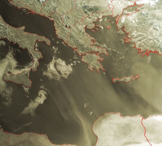
Dust storm out of Northern Africa
A thick streamer of pale dust sweeps across the Mediterranean Sea in this image from the Moderate Resolution Imaging Spectroradiometer (MODIS) on NASA’s Aqua satellite on March 20, 2007. The dust casts a thin beige veil over the lush green vegetation lining the banks of Egypt’s Nile River and its fan-shaped delta. The river of dust passes by the island of Crete (left edge) and reaches the shores of Turkey (top).
bron:
Heb me eens uitgelegt gekregen dat de zandstormen uit de sahara een belangrijke mineralenbron zijn voor het regenwoud van de amazone.
In Baden-Badener Badeseen kann man Baden-Badener baden sehen.


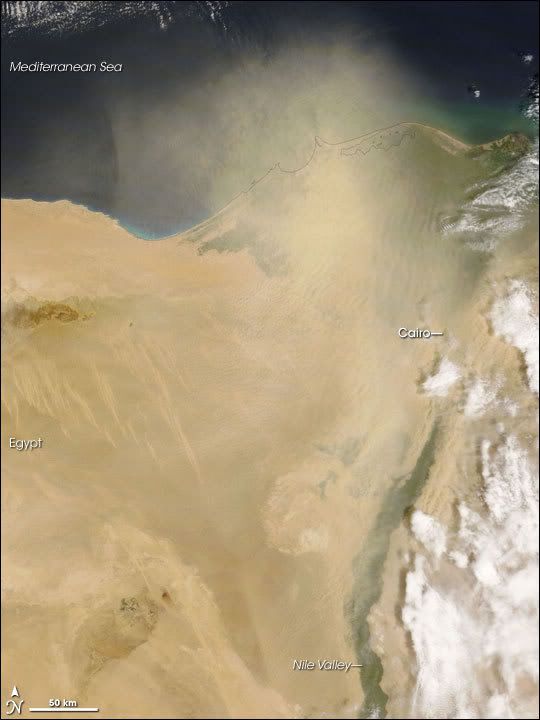
Nile Delta Dust Storm
On April 17, 2007, desert winds whipped up a severe dust storm over Cairo, according to the Associated Press. Poor visibility shut down Cairo’s airport for several hours. At 09:05 UTC the same day, the Moderate Resolution Imaging Spectroradiometer (MODIS) on NASA’s Terra satellite captured this image of dust blowing northward along the Nile and fanning out over the Mediterranean Sea.
In this image, dust partially obscures the view of the Nile well inland from the coastline. The dust grows especially thick near the coast, just west of the Nile Delta. A fine gray outline shows the coastal contour through the dust. Just southeast of the storm is a bank of clouds, potentially associated with the same weather system that kicked up the dust around Cairo.

Dust Storm in the Taklimakan Desert
Another dust storm blew out of the Taklimakan Desert on April 16, 2007. The Moderate Resolution Imaging Spectroradiometer (MODIS) on NASA s Terra satellite took this picture the same day.
This picture shows the western edge of the Taklimakan Desert and the Tien Shan Mountains to the north. Plumes of dust blow northward from the southwestern edge of the desert basin. The dust appears as a beige smudge running up the center of the image. Near the mountains, thin clouds obscure the view of the northern rim of the desert. Brighter and clearer than the clouds are the patches of snow cover on the mountain range.
The Taklimakan Desert sits between the Tien Shan Mountains in the north and Kunlun Mountains in the south. This desert is one of Earth s largest shifting-sand deserts, and it contains heavy concentrations of salt as it has no drainage. Its plentiful sand makes this desert is a regular source of Asian dust storms.

Dust Storm over Saudi Arabia and Iraq
A fast-moving dust storm struck northern Saudi Arabia and Iraq on April 27, 2007. The Moderate Resolution Imaging Spectroradiometer (MODIS) on NASA’s Terra satellite took this picture the same day.
For a satellite sensor to capture a wall of dust over a wide region is relatively rare, but this image captures a dust wall stretching across roughly 450 kilometers (280 miles). In this image, the buff-colored storm advances southward over slightly darker terrain. On its leading edge, the dust wall is distinct. To the north, the dust plume becomes more amorphous.
Terra captured this image at 0800 UTC on April 27. By the time the Aqua satellite passed over the region about an hour and a half later, the storm had advanced noticeably, as a comparison of satellite passes shows.


A dust plume several hundred kilometers across blew off the west coast of Africa on May 9, 2007. The Moderate Resolution Imaging Spectroradiometer (MODIS) on NASA’s Terra satellite took this picture the same day.
This image shows the dust plume fanning out approximately 500 kilometers west of the coast. The plume is thickest in the south, near Cape Verde, although a thin arm of dust stretches out toward the Canary Islands in the north. The thickest part of the plume is tan in color, while the thinnest portion appears ghostly gray. Over land, the dust is not thick enough to block the satellite’s view of the land surface.
Het zand steekt de Oceaan over richting Amerika (als dat al gehaald wordt).
[ Bericht 10% gewijzigd door #ANONIEM op 12-05-2007 00:09:22 ]
[ Bericht 10% gewijzigd door #ANONIEM op 12-05-2007 00:09:22 ]
Stofstorm zorgt voor chaos in India
Een stofstorm heeft donderdagavond in het noorden van India voor chaos gezorgd. Daarbij kwamen zeker 27 mensen om het leven.
De harde wind kwam in eerste instantie als een aangename afkoeling. In het gebied kwam de temperatuur al lange tijd dagelijks boven de 40 graden. Maar de harde wind ging gepaard met veel stof en ontregelde het maatschappelijk leven. Hevige windstoten zorgden ervoor dat bomen omvielen op huizen en enkele inwoners werden daarbij gedood. De hard warme wind zal de komende dagen aanhouden.
Dust Storm over the Persian Gulf
Dust lingered in the skies over the Persian Gulf on May 18, 2007. The Moderate Resolution Imaging Spectroradiometer (MODIS) on NASA’s Aqua satellite took this one day after a dust storm started over Saudi Arabia, Kuwait, Iran, and Iraq. In this image, buff-colored plumes of dust sweep from northwest to southeast over the water.
Dust lingered in the skies over the Persian Gulf on May 18, 2007. The Moderate Resolution Imaging Spectroradiometer (MODIS) on NASA’s Aqua satellite took this one day after a dust storm started over Saudi Arabia, Kuwait, Iran, and Iraq. In this image, buff-colored plumes of dust sweep from northwest to southeast over the water.

Dit vind ik wel heel,heel bizar.quote:Op maandag 26 maart 2007 14:55 schreef Frutsel het volgende:
Stofwolk boven België was Sahara-zand
[afbeelding]

Dust Plume off the Coast of Egypt
Dwarfing the Nile, a river of dust flowed out of the deserts of northern Egypt on May 19, 2007. As the Moderate Resolution Imaging Spectroradiometer (MODIS) on NASA’s Terra satellite passed overhead at 12:05 p.m. local time in Cairo, the sensor captured this image of the dust spreading northward over the Mediterranean Sea from the sandy deserts that span the country. At the margins of the plume, ribbons and ripples of dust are translucent, allowing a glimpse of the desert and water beneath, but in the center, the cloud is opaque, revealing nothing of the surface below.
The part of north-central Egypt hidden by the dust plume is the Qattara Depression, the country’s lowest point. Dipping down to 133 meters below sea level (436 feet), the depression is home to sandy deserts and dry lake beds that occasionally flood. The sand and fine, lake bed sediments are easily lofted into the air by strong winds that scour the area in late winter and early spring.
In the eastern (right-hand) part of the image, the Nile River is lined by narrow ribbons of dull green vegetation. The fan-shaped delta is dotted with tan-colored spots, marking the location of cities and towns. The Nile Valley and Delta make up only a small fraction of the country’s total land area, yet they support almost the entire population.

Smoke Plume over Eastern Canada
In late May, a massive smoke plume hundreds of kilometers across blew eastward over New Brunswick toward the Atlantic Ocean. On May 26, 2007, the Moderate Resolution Imaging Spectroradiometer (MODIS) on NASA’s Terra satellite captured this image at 11:40 a.m. local time. By the time MODIS took this picture, the smoke appeared to have completely detached itself from the source, a large fire burning in southwestern Quebec, beyond the western edge of this image.
In this image, the smoke appears as a gray-beige opaque mass with fuzzy, translucent edges. The plume is thickest in the southwest and diminishes toward the northeast. Just southwest of the plume is a red outline indicating a hotspot—an area where MODIS detected anomalously warm surface temperatures, such as those resulting from fires. This hotspot, however, is not the source for this smoke plume. According to a bulletin from the National Oceanic and Atmospheric Administration, the southwestern Quebec fire (visible in this wider-area view as a semi-circular arrangement of hotspots at image left) was the source.
According to reports from the Canadian Interagency Forest Fire Centre on May 29, that fire was estimated at 63,211 hectares (156,197 acres), and it was classified as “being held.” At the same time, more than 20 wildfires burned in Quebec, news sources reported, and firefighters from other Canadian provinces and the United States had been brought in to provide reinforcements for the area’s firefighters.

Dust Plume over Cape Verde
Dust blew off the west coast of Africa and over Cape Verde on June 17, 2007. The Moderate Resolution Imaging Spectroradiometer (MODIS) on NASA’s Terra satellite captured this image the same day. This picture shows the dust plume, hundreds of kilometers across, billowing over the Atlantic. Dust mingles with clouds over Cape Verde. To the west of the archipelago, clouds predominate.

Fruts dit is een tvp..dit wil ik ff lezen als ik tijd heb..
Love can move you..take you deeper everytime
Love can move you..to a place inside your heart
Love can move you..to a place inside your heart
Hoe komt het dat ze zo langzaam gaan?
In strips zijn zand- en stofstormen altijd heel gewelddadig en hard
In strips zijn zand- en stofstormen altijd heel gewelddadig en hard
Gelukkig ben ik gelukkig.
Treats me like a Cinderella, protects me from the storm like he's my umbrella
Treats me like a Cinderella, protects me from the storm like he's my umbrella
Hier nog een leuke van afgelopen week in Arizona USA
http://news.sky.com/skyne(...),30200-1275589,.html
http://news.sky.com/skyne(...),30200-1275589,.html

JULY 20 - Dust Plume off Western Africa
A thick plume of dust blew off the west coast of northern Africa on July 20, 2007. The Moderate Resolution Imaging Spectroradiometer (MODIS) flying on NASA’s Aqua satellite took this picture the same day. This image shows the beige-tan plume—thick enough to be completely opaque in places—over the Atlantic Ocean. The source of the plume is not obvious in this image, and given the plume’s diffuse shape, it may have originated farther east.
South of the plume, a wave pattern appears. Both airborne dust and clouds can make waves in the atmosphere visible to satellite sensors. The northern portions of these waves are faint, but as they meld with cloud formations in the south, the waves become easier to discern. Just north of the waves, the ocean water takes on a pale green color, which may be due to shallow water, sediment and/or algae.

JULY 16 - Saharan Dust Plume
Saharan dust blew off the west coast of Africa and over the Atlantic on July 16, 2007. The Moderate Resolution Imaging Spectroradiometer (MODIS) flying on NASA’s Terra satellite took this picture the same day. In this image, the dust forms a thick plume of tan that mingles with white clouds over the ocean. After blowing out over the water, the dust swirls back toward land in the south, forming an arc several hundred kilometers across

22 JUNE - Dust Plume off Western Africa
The Saharan dust plume that departed Africa on June 22, 2007, was hovering over the Caribbean Sea five days later. The Moderate Resolution Imaging Spectroradiometer (MODIS) on NASA’s Terra satellite took this picture on June 27, 2007. In this image, the dust appears as a very thin veil of brownish haze over the ocean.
17 JUNE -Dust Plume over Cape Verde
Dust blew off the west coast of Africa and over Cape Verde on June 17, 2007. The Moderate Resolution Imaging Spectroradiometer (MODIS) on NASA’s Terra satellite captured this image the same day. This picture shows the dust plume, hundreds of kilometers across, billowing over the Atlantic. Dust mingles with clouds over Cape Verde. To the west of the archipelago, clouds predominate.
=============
Vraag me af of deze Zandstormen enig effect hebben op de Orkanen in de Atlantische Oceaan richting de Golf (zie --> Hurricane season 2007 deel 2

Dust Storm over Afghanistan
On August 12, 2007, a dust storm formed where the borders of Iran, Afghanistan, and Pakistan meet. The Moderate Resolution Imaging Spectroradiometer (MODIS) flying on NASA’s Terra satellite took this picture the same day. This image shows the pale beige plumes of dust sweeping from the northwest in a counter-clockwise direction. The image also shows some of the source points for the plumes. From source points along the Iran-Afghanistan border, the storm covers part of northern Pakistan.
Coole pics...en mooie teksten erbij
Heb zelf weleens een mini zandstorm meegemaakt. We waren op vakantie op Gran Canaria. En we gingen toen slapen, volgende dag werden we wakker, hele tuin vol met zand, tuinmeubilair was niet meer zichtbaar, het was echt overal, we deden de schuifpui open, zootje zand naar binnen. Was heel apart. Ik was toen 12 ofzo.
Het stelt niet veel voor natuurlijk...maar het was weer eens wat anders
Zandstormen verwoesten deel Chinese Muur
PEKING - Zandstormen hebben tientallen kilometers van de Chinese Muur verwoest. Dat berichtte het persbureau Xinhua woensdag. In de noordoostelijke provincie Gansu is de afgelopen twintig jaar 40 kilometer Muur verdwenen, meldden archeologen.
In het district Minqin van Gansu is het gebied door te intensief landgebruik veranderd in een woestijn. Door zandstormen is de historische structuur ernstig beschadigd, aldus Xinhua. De Muur is 6400 kilometer lang en trekt jaarlijks 10 miljoen bezoekers.
Dit deel van de Chinese Muur was gemaakt van modder en niet van steen en wordt daardoor sneller aangetast, aldus voormalig curator Zhou Shengrui van het Minqin Museum. Elders in het land is de Muur ook aangetast door erosie, maar hier is het veel erger, zei hij.
http://www.telegraaf.nl/b(...)el_Chinese_Muur.html

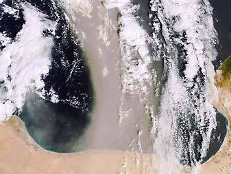
Dust Storm over Bahrain and Qatar
Saudi Arabian dust blew over Bahrain, Qatar, and the Persian Gulf on September 12, 2007. The Moderate Resolution Imaging Spectroradiometer (MODIS) on NASA’s Terra satellite took this picture the same day. In this image, the dust appears as a pale beige arc moving in a clockwise direction. Although the dust is thin along the margins of the plume, near the center of the arc, it is thick enough to almost completely hide the island nation of Bahrain.
Zware zandstorm treft Californië
Een zandstorm heeft in Californië aan vier mensen het leven gekost. De mensen kwamen om het leven door verkeersongelukken.
In de zandstorm daalde het zicht plaatselijk tot nul meter. Hierdoor ontstonden behoorlijk wat aanrijdingen. Vooral Lancaster ten noorden van Los Angeles werd getroffen. De storm ging gepaard met windstoten van 90 kilometer per uur. Het gebied beleeft dit jaar een van de droogste tijden ooit.
vwk
opnieuw stofstorm voor Koeweit
Koeweit is voor de tweede keer in een week getroffen door een stofstorm. Door de stofstorm werden dinsdag drie havens gesloten en raakte het vliegverkeer ontregeld. Stofstormen zijn zeldzaam in de winter.
De stofstormen zijn een gevolg van de droogte. Normaal valt er in de winterperiode enige neerslag, maar de laatste maanden is dit in Koeweit minder voorgekomen. Hierdoor kon gemakkelijk zand en stof uit de woestijn worden aangevoerd.
Stofstormen ontstaan doorgaans in de zomer. Wanneer de shamalwind harder waait dan 25 kilometer per uur, worden zand- en stofdeeltjes meegevoerd. Dinsdag daalde het zicht tot minder dan 300 meter.
vwk
Ik heb eens gelezen dat, omdat de zon niet kan doordringen in zulke stormen, allerlei virussen e.d. kunnen overleven. Als zo'n storm dus een ander continent bereikt, kunnen zo ziektes verspreidt worden. Men vermoedt dat ook BSE op die manier is overgewaaid.
Inderdaad gaat de waarde die wij aan de mening van anderen hechten (...) in de regel bijna elke redelijke bedoeling te boven, zodat het als een soort algemeen verbreide of veeleer aangeboren manie kan worden beschouwd - Schopenhauer
China dust storm hits East Asia
The dust picks up toxins as it passes over Chinese factories
Yellow dust storm
A huge cloud of choking dust is passing over South Korea as the first sand storm of the year blows in from China. South Korea has ordered schools to close and drivers in south-west Japan have been warned about low visibility from the dust clouds.
Every spring brings "yellow dust" storms which blow sand from China's Gobi Desert over the Koreas and Japan.
The dust storms have become more deadly each year as they pass over China's industrial zones picking up toxins.
South Korea blames dozens of deaths every year on the storms, mostly of elderly people and those with respiratory problems.
South Korean authorities advised parents to keep younger children at home to avoid the dust.
"We have advised the closure because kindergarten, primary school students have weaker immune systems," Min Eyu-gi, an education official in the southern city of Busan, told Reuters news agency.
Seasonal winds lasting from late February to April or May combine with dry winter weather to pick up millions of tonnes of sand from China's northern deserts.
The storms turn the sky a yellow colour and coat everything in a layer of fine dust.
The dust picks up toxins as it passes over Chinese factories

Yellow dust storm
A huge cloud of choking dust is passing over South Korea as the first sand storm of the year blows in from China. South Korea has ordered schools to close and drivers in south-west Japan have been warned about low visibility from the dust clouds.
Every spring brings "yellow dust" storms which blow sand from China's Gobi Desert over the Koreas and Japan.
The dust storms have become more deadly each year as they pass over China's industrial zones picking up toxins.
South Korea blames dozens of deaths every year on the storms, mostly of elderly people and those with respiratory problems.
South Korean authorities advised parents to keep younger children at home to avoid the dust.
"We have advised the closure because kindergarten, primary school students have weaker immune systems," Min Eyu-gi, an education official in the southern city of Busan, told Reuters news agency.
Seasonal winds lasting from late February to April or May combine with dry winter weather to pick up millions of tonnes of sand from China's northern deserts.
The storms turn the sky a yellow colour and coat everything in a layer of fine dust.

Dust Storm at White Sands, New Mexico
On March 14, 2008, a dust storm struck southern New Mexico, near the borders with Texas and Mexico. The dust came from White Sands National Monument. At White Sands, pale gypsum sand covers some 715 square kilometers (275 square miles) of desert, providing ample material for storms when strong winds strike.
This image, acquired on March 14 by the Moderate Resolution Imaging Spectroradiometer (MODIS) on NASA’s Aqua satellite, shows the dust storm blowing eastward away from the national park. The white gypsum dunes contrast sharply with the surrounding landscape, and the dust plumes emerging from the park share the same characteristic color. Outside of the park, patches of green attest to the presence of vegetation, but the region is mostly arid, with earth tones predominating.

Dust Plumes over Syria and Iraq
A dust storm struck the Middle East in mid-March 2008, blowing primarily through Syria and Iraq. The Moderate Resolution Imaging Spectroradiometer (MODIS) on NASA’s Aqua satellite took this picture on March 15, 2008.
Clear skies over the Syrian coast and source points of the dust storm in the west indicate that the dust is blowing from west to east in this image. The dust plumes form an arc moving in counter-clockwise direction, barely grazing Jordan, and finally encountering clouds over Iraq

Dust over the Persian Gulf and Saudi Arabia
Dust plumes blew over the Persian Gulf and Saudi Arabia in mid-March 2008. The Moderate Resolution Imaging Spectroradiometer (MODIS) on NASA’s Terra satellite took this picture on March 14, 2008.
In this image, a thick plume of dust blows over Iran, the Persian Gulf, the island nation of Bahrain, and Saudi Arabia. The dust narrowly misses the Qatar Peninsula. Although source points for the plumes are not apparent in this image, the dust appears to blow from the north and move in a clockwise direction to the southwest. West of the most conspicuous dust plume, smaller plumes blow over Saudi Arabia. Clear skies immediately east of these smaller plumes suggest that the plumes originate within Saudi Arabia. Clouds appear over Iran in the upper right corner of this image, and they could be associated with the same weather system that stirred the dust.
Dust Storm off the African West Coast
On March 29, 2008, the Moderate Resolution Imaging Spectroradiometer (MODIS) on NASA’s Terra satellite captured this image of dust storm activity off the west coast of Africa. This image shows the second consecutive day’s dust plume activity off Africa’s coast. In this image, the dust, although thinner than that of the previous day, has spread over a wider range. The dust has both moved farther south, and skirted Cape Verde in the west.
NASA image courtesy Jeff Schmaltz, MODIS Rapid Response team. Caption by Michon Scott.
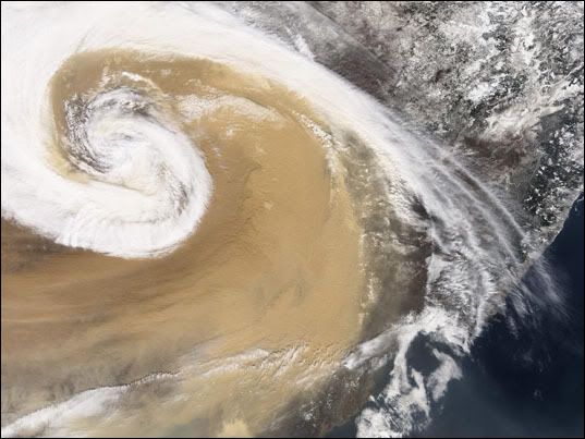
Deze gigantische stofstorm reisde in april 2001 vanuit Azië over de Stille Oceaan naar de Verenigde Staten.Bron: NASA
bron:
bron:

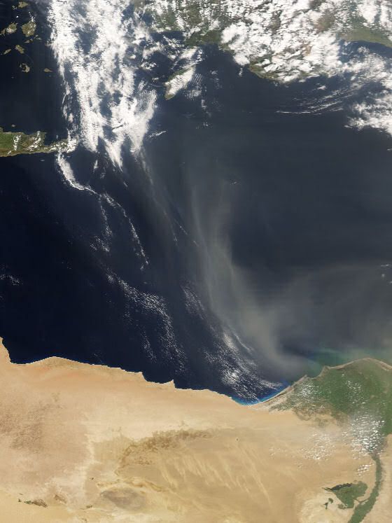
Dust Storm off Egypt
A thick plume of dust blew off the northern coast of Egypt, west of the Nile Delta, and over the Mediterranean Sea on September 25, 2008. The Moderate Resolution Imaging Spectroradiometer (MODIS) on NASA’s Aqua satellite captured this image the same day. In this image, the dust swirls in a counter-clockwise direction toward the northwest. A thinner plume in the east mimics the motion of the larger, thicker plume. Source points for this dust storm are not apparent in this image, but the dust likely arose from the sand seas farther inland in Egypt and/or Libya.
===
toch wel apart zon krul
|
|