WKN Weer, Klimaat en Natuurrampen
Lees alles over het onstuimige weer op onze planeet, volg orkanen en tornado's, zie hoe vulkanen uitbarsten en hoe Moeder Aarde beeft bij een aardbeving. Alles over de verwoestende kracht van onze planeet en tal van andere natuurverschijnselen.


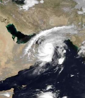
Klopt, Oman wordt niet zo vaak getroffen, kortom, gaat weer wat schade komen
Doe mee met het voorspellen van het weer!
Weekvoorspelling | Week 12 (invullen tot 16-03 - 11:59)
Maandvoorspelling Maart (Inzendingen gesloten)
Jaarvoorspelling 2025 / 2026
Weekvoorspelling | Week 12 (invullen tot 16-03 - 11:59)
Maandvoorspelling Maart (Inzendingen gesloten)
Jaarvoorspelling 2025 / 2026

Ik denk dat deze storm, zeker door de verwachte koers, een igen topic verdiend.
Officiele forecast:
REMARKS:
040900Z POSITION NEAR 19.4N 64.5E.
TROPICAL CYCLONE (TC) 02A (GONU), LOCATED APPROXIMATELY 440 NM
SOUTHEAST OF MUSCAT, OMAN, HAS TRACKED NORTHWESTWARD AT 09 KNOTS
OVER THE PAST 06 HOURS. TRACK REASONING REMAINS THE SAME AS THE
PREVIOUS FORECAST, ALTHOUGH UNCERTAINTY IN THE LATER TAUS REMAINS
AS THE DYNAMIC AIDS CONTINUE TO DIVERGE AFTER TAU 48. TC 02A
CONTINUES TO TRACK NORTHWESTWARD ALONG THE SOUTHWESTERN PERIPHERY
OF A MID-LEVEL STEERING RIDGE ANCHORED OVER CENTRAL INDIA. THE
SYSTEM WILL ENCOUNTER A SECOND RIDGE ANCHORED OVER THE ARABIAN
PENINSULA AS IT CONTINUES TO TRACK NORTHWESTWARD. HOWEVER, A
SERIES OF MID-LATITUDE TROUGHS APPROACHING FROM THE NORTH AND
WEST OF THE THE RIDGE AXIS ARE EXPECTED TO MAINTAIN A WEAKNESS
BETWEEN THE RIDGE CENTERS OVER INDIA AND SAUDI ARABIA, ALLOWING
TC 02A TO TRACK TOWARD THE NORTHEAST COAST OF OMAN THROUGH THE
FORECAST PERIOD. THE NOGAPS AND GFDN NUMERICAL MODELS DEPICT A
STRONG WEAKNESS IN THE RIDGES CAUSED BY ONE OF THE AFOREMENTIONED
MID-LATITUDE TROUGHS BETWEEN TAU 48 AND 72, WHICH WOULD INDICATE
A RECURVATURE SCENARIO THAT WOULD TAKE THE SYSTEM INTO THE GULF
OF OMAN TOWARD THE COAST OF IRAN IN THE EXTENDED PERIOD. EGRR,
GFS, AND AFWA MM5 DEPICT A WEAKER TROUGH, LESS OF A WEAKNESS
IN THE RIDGING AND THEREFORE A MORE WESTWARD TRACK. THE EXACT
TRACK OF THE SYSTEM WILL DEPEND HIGHLY ON THE LOCATION AND MAGNITUDE
OF THIS RIDGE WEAKNESS INDUCED BY THE DEVELOPING MID-LATITUDE
TROUGHS. THIS FORECAST IS BASED ON A CONSENSUS OF THE AVAILABLE
MODELS WITH LESS EMPHASIS TOWARD NOGAPS AND GFDN AT TAU 72 SINCE
THIS IS THE FIRST MODEL RUN THAT IS DEPICTING THE RECURVE SCENARIO.
THE STORM CONTINUES TO REMAIN UNDER AN EXTENSIVE UPPER LEVEL RIDGE
AXIS, WITH LOW VERTICAL WIND SHEAR AND EXCELLENT WESTWARD AND
POLEWARD OUTFLOW. THESE FAVORABLE UPPER LEVEL CONDITIONS HAVE LED
TO RAPID INTENSIFICATION OVER THE PAST 18 HOURS. THE SYSTEM IS
EXPECTED TO WEAKEN SLIGHTLY OVER THE NEXT 24 HOURS AS IT MOVES
OVER LOWER OCEAN HEAT CONTENT, BUT MAINTAINS FAVORABLE UPPER LEVEL
OUTFLOW. TC 02A IS FORECAST TO WEAKEN MORE QUICKLY AFTER TAU 24
DUE TO THE ENTRAINMENT OF DRY AIR FROM THE ARABIAN PENINSULA AND
THEN LAND EFFECTS AFTER LANDFALL NEAR TAU 48. MAXIMUM SIGNIFICANT
WAVE HEIGHT AT 040600Z IS 40 FEET. NEXT WARNINGS AT 041500Z, 042100Z,
050300Z AND 050900Z.//
https://metocph.nmci.navy.mil/jtwc/warnings/io0207web.txt
Deze cycloon (zoals deze genoemd worden in dit deel van de wereld), volgt een aparte route. Normaal ontstaan er al vrij weinig stormen rond de westkust van India. En als deze er al zijn, koersen ze meestal naar het westen of zuidwesten. Of deze verdwijnen al op de oceaan, of ze komen richting Madagaskar / mozambique uit. Meestal sterk verzwakt.
Nu gaat het pad naar het noord westen, in de richting van Oman.
Oman is een woestijnland, waar het aan de kust vochtig heet is. 45 graden komt regelmatig voor. Het binnenland is heet en drooog.
Een belangrijke (belangrijkste) bron van inkomsten is, het is natuurlijk het midden oosten) olie.
Mocht deze storm Oman hard raken, zou dat ook een invloed kunen heben op de olieprijs en daaraan gekoppeld ook de gas en electra prijs.
We zullen dat dan ook vrijwel direct merken aan de pomp.
hierna KAN Gonu verzwakken, maar komt dan misschien weer boven de (warme) Perzische golf uit. daar kan dus ook weer schade ontstaan.
Al met al moeten we de ontwikkelingen goed volgen. Het is een aparte storm met misschien wel grote invloeden.
Ik HAAT mijn toetsenbord.

Central Command van de Amerikanen over álles wat er zo'n beetje in die buurt gebeurt (Irak, Afghanistan, Somalië, Iran etc) zit toch ook daar?
LastFM
03/06 Maccabees - 10/06 Gaslight Anthem - 18/06 Oi Vai Voi - 20/06 Green Beats - 24/06 Ghinzu - 18/07 Extrema Outdoor
03/06 Maccabees - 10/06 Gaslight Anthem - 18/06 Oi Vai Voi - 20/06 Green Beats - 24/06 Ghinzu - 18/07 Extrema Outdoor

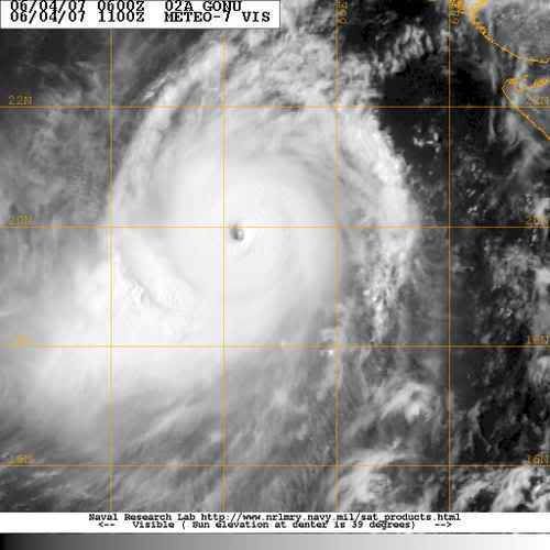
Wow .. Tropical Cyclone Gonu is nu Catogorie 5 !!
Windsnelheden : 260km per uur !
Uitschieters : 313km per uur !

Windsnelheden : 260km per uur !
Uitschieters : 313km per uur !
2007 = Supper orkaan zeisoen !
Cool zou je daar maar in zitten
Doe mee met het voorspellen van het weer!
Weekvoorspelling | Week 12 (invullen tot 16-03 - 11:59)
Maandvoorspelling Maart (Inzendingen gesloten)
Jaarvoorspelling 2025 / 2026
Weekvoorspelling | Week 12 (invullen tot 16-03 - 11:59)
Maandvoorspelling Maart (Inzendingen gesloten)
Jaarvoorspelling 2025 / 2026
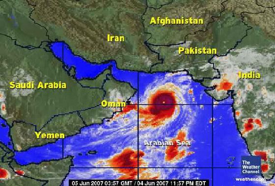
Oman on alert for cyclone - official news agency
DUBAI, June 4 (Reuters) - Gulf oil producer Oman ahead of the expected landfall of a cyclone has called a state of emergency for its army and police and called for people to leave dangerous areas, naming two islands, the official ONA news agency said on Monday.
Oman's weather service warned that the cyclone will have winds of 185-205 km (114-128 miles) per hour cause "very high waves".
Oman is an independent oil exporter pumping around 715,000 barrels per day of crude oil and condensates.
vriend van mij werkt en woont in die regio, volgens mij zijn ze dat niet erg gewend daar Als hij klaagt over orkanen zit hij altijd in Taiwanquote:Op maandag 4 juni 2007 18:52 schreef aloa het volgende:
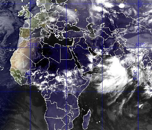
Dat gaat een flinke zandstorm worden
[afbeelding]
[b]Op maandag 6 september 2010 00:28 schreef tong80 het volgende:[/b]
GVD Wat moet jij een trotse vader zijn :)
:P
GVD Wat moet jij een trotse vader zijn :)
:P
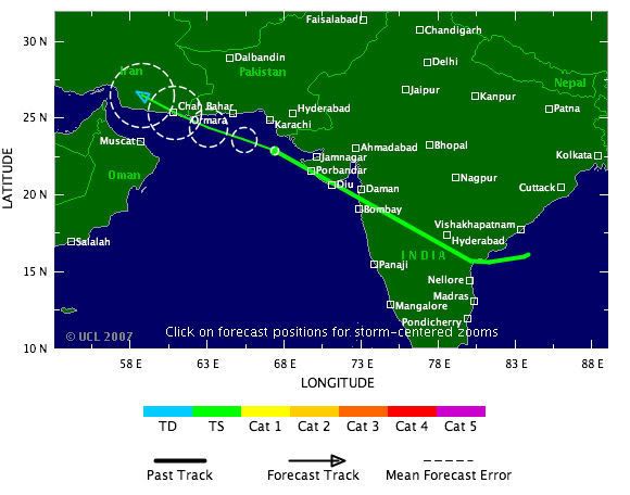
Tropical Cyclone Gonu in Arabian Sea
A powerful tropical cyclone is churning through the Arabian Sea toward Oman and Iran. Tropical Cyclone Gonu, with maximum sustained winds of 160 mph, is the equivalent of a category five hurricane.
Gonu is moving off toward the west-northwest and on its current course it would come very close to the northeast tip of Oman late Tuesday afternoon and evening (U.S. time). Gonu is forecast to weaken some, but would still be the equivalent of a category three hurricane as it passes close to Oman.
The current forecast keeps the eye of Gonu over water as it brushes by Oman and then turns the system toward southern Iran. Should the center remain over water it could hit Iran with maximum winds close to 75 mph.
While tropical storms have hit Oman in the past, they are rare, and there is no record of a hurricane-strength cyclone striking the country. The last tropical storm to smack the nation was in May 2002.
Meanwhile, in the Atlantic and eastern Pacific Basins, there are no imminent threats of tropical cyclone development.
The remnants of Tropical Storm Barry are belting northern New England and Upstate New York with heavy rain and gusty winds this afternoon. While some localized flooding will occur, no major damage is anticipated. New York City's Central Park picked up 3.91 inches of rain due to the remnants of Barry.
Zeer interessant artikel:
http://dutch.wunderground.com/blog/JeffMasters/comment.html?entrynum=690&tstamp=200706
Dit kan dus goed fout gaan.
mensen, ga snel tanken!
http://dutch.wunderground.com/blog/JeffMasters/comment.html?entrynum=690&tstamp=200706
Dit kan dus goed fout gaan.
mensen, ga snel tanken!
Ik HAAT mijn toetsenbord.
De verzakking van Gonu is vrijwel uitgebleven. Climatologisch niet te verklaren, immers is het zeewater momenteel koeler!
Oman heeft nu regen. De zwaarste klappen zijn voor vannacht/ morgenochtend. Daarna is Iran absoluut aan de beurt. Oman cat 3, Iran cat 2...
Maar een groot probleem zal de neerslag zijn.
Oman heeft nu regen. De zwaarste klappen zijn voor vannacht/ morgenochtend. Daarna is Iran absoluut aan de beurt. Oman cat 3, Iran cat 2...
Maar een groot probleem zal de neerslag zijn.
Ik HAAT mijn toetsenbord.
Dat is onzin, want ik woon er. Voorzover ik weet is er alleen wat motregen geweest in eht westen. Maar de rest is wel waar! Mensen zijn al aan het evacueren in Muscat en de scholen zijn gesloten. Het verhaal gaat dat het binnen 4 uur gaat beginnen!quote:Op dinsdag 5 juni 2007 11:35 schreef tweakdsl het volgende:
De verzakking van Gonu is vrijwel uitgebleven. Climatologisch niet te verklaren, immers is het zeewater momenteel koeler!
Oman heeft nu regen. De zwaarste klappen zijn voor vannacht/ morgenochtend. Daarna is Iran absoluut aan de beurt. Oman cat 3, Iran cat 2...
Maar een groot probleem zal de neerslag zijn.
Cool story, Hansel.
Wat gebeurt er?
Er is pasgeleden een Orkaan [of cycloon] gevormd in de Golf van Oman, Cycloon Gonu. Er is veel heisa onstaan en er word druk geevacueerd. De scholen zijn al geslotenen veel mensen die aan de rand van de stad wonen zijn gestopt met werken en proberen nu naar huis te gaan.
Hoe ziet hij eruit?
Nou zo:
Hij draait met zo'n snelheid van 155 Mijlen per uur en beweegt zich met ongeveer 7-10 mph voort.
Wanneer raakt hij Muscat/Oman?
Het gerucht gaat nu dat hij binnen vier uur Muscat zal raken. Officieel wordt het morgenochtend tot en met donderdag of vrijdag.
Wat merk je er zelf van?
ik doe examens en die zijn niet [ ] afgelast maar als je door het weer niet kan komen dan hoeft het niet. Verder zijn de scholen al gesloten [behalve voor mensen die examens doen dan] en gaan er een hoop mensen al naar huis. Ik heb wat fotos genomen van het verkeer dat ongeveer vast staat:
Dat is dus de snelweg die naar de buitenwijken gaat.
De brief van school:
En de wolken [wat hier niet zo veel voorkomt]
En de zee staat al aardig hoog, maar er zijn nog niet zoveel golven.
Waarom doe je dit?
Het leek me leuk/interessant om mensen er actueel van op de hoogte te houden!
Ik geloof je niet, ik wil bewijs!
Het staat al in het nieuws maar hier nog meer plaatjes van Gonu:
http://uploader.ws/upload/200706/image005.jpg
http://uploader.ws/upload/200706/image006.jpg
http://uploader.ws/upload/200706/image002.gif
Nieuwslinks
Link 1
Link 2
Link 3
En ik wacht af wat er gebeuren zal
[ Bericht 11% gewijzigd door wikwakka2 op 05-06-2007 12:17:32 (Meer pics) ]
Er is pasgeleden een Orkaan [of cycloon] gevormd in de Golf van Oman, Cycloon Gonu. Er is veel heisa onstaan en er word druk geevacueerd. De scholen zijn al geslotenen veel mensen die aan de rand van de stad wonen zijn gestopt met werken en proberen nu naar huis te gaan.
Hoe ziet hij eruit?
Nou zo:

Hij draait met zo'n snelheid van 155 Mijlen per uur en beweegt zich met ongeveer 7-10 mph voort.
Wanneer raakt hij Muscat/Oman?
Het gerucht gaat nu dat hij binnen vier uur Muscat zal raken. Officieel wordt het morgenochtend tot en met donderdag of vrijdag.
Wat merk je er zelf van?
ik doe examens en die zijn niet [ ] afgelast maar als je door het weer niet kan komen dan hoeft het niet. Verder zijn de scholen al gesloten [behalve voor mensen die examens doen dan] en gaan er een hoop mensen al naar huis. Ik heb wat fotos genomen van het verkeer dat ongeveer vast staat:

Dat is dus de snelweg die naar de buitenwijken gaat.
De brief van school:

En de wolken [wat hier niet zo veel voorkomt]

En de zee staat al aardig hoog, maar er zijn nog niet zoveel golven.

Waarom doe je dit?
Het leek me leuk/interessant om mensen er actueel van op de hoogte te houden!
Ik geloof je niet, ik wil bewijs!
Het staat al in het nieuws maar hier nog meer plaatjes van Gonu:
http://uploader.ws/upload/200706/image005.jpg
http://uploader.ws/upload/200706/image006.jpg
http://uploader.ws/upload/200706/image002.gif
Nieuwslinks
Link 1
Link 2
Link 3
En ik wacht af wat er gebeuren zal
[ Bericht 11% gewijzigd door wikwakka2 op 05-06-2007 12:17:32 (Meer pics) ]
Cool story, Hansel.
Dat heb ik nog niet eerder gezien, een orkaan in dat gebied. En het is een zware jongen ook nog! Ben benieuwd wel gebied getroffen gaat worden en hoe zwaar.
er wordt geëvacueerd, maar de examens gaan wel door?
Wie verzint dat?
Wie verzint dat?
If you wish to be a success in the world, promise everything, deliver nothing.
Nothing is more difficult, and therefore more precious, than to be able to decide.
Victory belongs to the most persevering
Nothing is more difficult, and therefore more precious, than to be able to decide.
Victory belongs to the most persevering
Idd lichte regen en motregen uit de buitenste banden bewolking.quote:Op dinsdag 5 juni 2007 11:46 schreef wikwakka2 het volgende:
[..]
Dat is onzin, want ik woon er. Voorzover ik weet is er alleen wat motregen geweest in eht westen. Maar de rest is wel waar! Mensen zijn al aan het evacueren in Muscat en de scholen zijn gesloten. Het verhaal gaat dat het binnen 4 uur gaat beginnen!
Maar er komt veel en veel meer. Ik wens je succes! Woon je in Muscat?
Ik HAAT mijn toetsenbord.
Nieuwsbronnen staan er nu ook bij.
En ja de examens gaan gewoon door Dat is nou de Britse mentaliteit.
MASD, werkt uploader.ws niet bij jou dan? Hier werkt ie gewoon.
En ja de examens gaan gewoon door Dat is nou de Britse mentaliteit.
MASD, werkt uploader.ws niet bij jou dan? Hier werkt ie gewoon.
Cool story, Hansel.
delete je cookies en je zult zien dat het niet aan mij ligtquote:Op dinsdag 5 juni 2007 12:19 schreef wikwakka2 het volgende:
Nieuwsbronnen staan er nu ook bij.
En ja de examens gaan gewoon door Dat is nou de Britse mentaliteit.
MASD, werkt uploader.ws niet bij jou dan? Hier werkt ie gewoon.
Long live music.
Kan deze stomr dan ook zoveel water opstuwen dat de opsgespoten eilandjes bij saudie arabie dan overstromen?
Volgens mij bedoel je bij de Emiraten?
Dubai?
Dat denk ik niet. Het gevaar zit suidelijker, buiten de Perzische golf.
Dubai?
Dat denk ik niet. Het gevaar zit suidelijker, buiten de Perzische golf.
Ik HAAT mijn toetsenbord.

Fuck, die crappy huizen die je ziet op doe Google Maps gaan echt helemaal naar de klote
LastFM
03/06 Maccabees - 10/06 Gaslight Anthem - 18/06 Oi Vai Voi - 20/06 Green Beats - 24/06 Ghinzu - 18/07 Extrema Outdoor
03/06 Maccabees - 10/06 Gaslight Anthem - 18/06 Oi Vai Voi - 20/06 Green Beats - 24/06 Ghinzu - 18/07 Extrema Outdoor
In de pacific zijn volgens mij al wat cat. 5 typhoons geweest.quote:Op dinsdag 5 juni 2007 14:07 schreef Catogorie5 het volgende:
Is dit trouwens de 1st Catogorie 5 was het jaar 2007 ?
/ ¦ ¦ / ¦ ¦
Ja die bedoel ik idd in dubaiquote:Op dinsdag 5 juni 2007 12:42 schreef tweakdsl het volgende:
Volgens mij bedoel je bij de Emiraten?
Dubai?
Dat denk ik niet. Het gevaar zit suidelijker, buiten de Perzische golf.
[b]Update[/bold]
We worden geevacueerd Aangezien onze straat tussen twee bergen in ligt moeten we naar een huis op de berg. Zo ook minstens drie andere straten in onze wijk.
Ze verwachten dat het water in onze huizen komt te staan dus alle belangrijke dingen moeten naar boven worden gebracht. Wat een gedoe.
We worden geevacueerd Aangezien onze straat tussen twee bergen in ligt moeten we naar een huis op de berg. Zo ook minstens drie andere straten in onze wijk.
Ze verwachten dat het water in onze huizen komt te staan dus alle belangrijke dingen moeten naar boven worden gebracht. Wat een gedoe.
Cool story, Hansel.
Foto van 18.00 uurquote:Tropical Cyclone Gonu is weakening as it churns toward the Gulf of Oman from the Arabian Sea. As of 8 a.m. EDT, Gonu's maximum sustained winds were down to 120 mph (from 160 mph yesterday).
Gonu is expected to continue weakening as it brushes by the northeast tip of Oman (Ra's al Hadd) over the next several hours. Weakening influences include slightly cooler ocean water, dry air from the Arabian Peninsula and Iran, interaction with land, and increasing vertical wind shear.
The cyclone is forecast to turn northward in the Gulf of Oman and strike the southern coast of Iran (Makran Coast) late tomorrow U. S. time. By the time it makes landfall, winds are expected to be down to 80 mph (a category one equivalent). Flash flooding will be a major threat.
Since 1945, there is no record of any type of tropical cyclone striking Iran.
Is inmiddels gebeurd.quote:Op dinsdag 5 juni 2007 15:36 schreef Party_P het volgende:
Kan dit topic niet gemerged worden met deze: Cyclone Gonu- cat 4/5 naar Oman
Meer info ook --> Hurricane Season 2007- there is BARRY

Tropical Cyclone Gonu
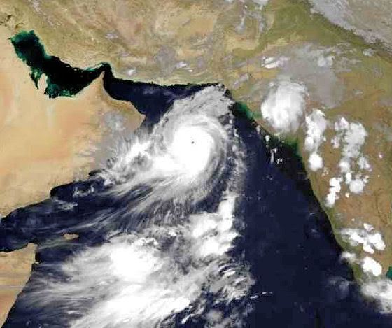
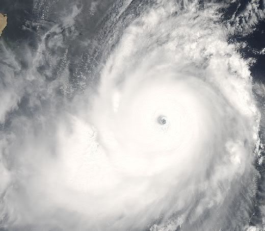
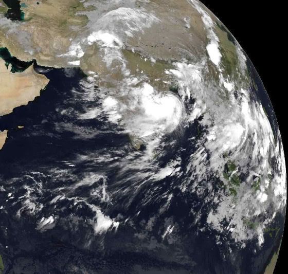
A storm with near-perfect symmetry and a well-defined eye hovering over the warm waters of the Caribbean or in the South Pacific is not unusual, but Tropical Cyclone Gonu showed up in a rather different place: the Arabian Sea. Though rare, cyclones like Gonu are not unheard of in the northern Indian Ocean basin. Most cyclones that form in the region form over the Bay of Bengal, east of India. Those that take shape over the Arabian Sea, west of the Indian peninsula, tend to be small and fizzle out before coming ashore. Cyclone Gonu was a rare exception. According to storm statistics maintained on Unisys Weather, the last storm of this size to form over the Arabian Sea was Cyclone 01A, which tracked northwest along the coast of India between May 21 and May 28, 2001. Unlike Gonu’s forecasted track, Cyclone 01A’s path never brought it ashore.
At 9:35 a.m. local time (06:35 UTC) on June 5, 2007, when the Moderate Resolution Imaging Spectroradiometer (MODIS) on NASA’s Terra satellite captured this image, Tropical Cyclone Gonu was approaching the northeastern shore of Oman. At this time, the powerful storm had reached a dangerous Category 4 status. Sustained winds were measured at 250 kilometers per hour (155 miles per hour) according to the University of Hawaii’s Tropical Storm Information Center, at the time of this MODIS image. The storm has the hallmark tightly wound arms that spiral around a well-defined, circular eye. The eye is surrounded by a wall of towering clouds that cast shadows on the surrounding clouds. Called hot towers, these clouds are a sign of the powerful uplift that feeds the storm. The symmetrical spirals, distinct eye, and towering clouds are all features regularly seen in satellite images of other particularly powerful cyclones, which are also known as typhoons or hurricanes when they form in other parts of the world.
The forecast as of June 5 called for the storm to graze Oman’s shore, but with the center of the storm staying offshore in the Gulf of Oman. The storm’s first landfall was predicted to be in southern Iran. The cooler water along the Oman coast was expected to rob the storm of some of its intensity, and it was predicted to strike the Iranian coast at around Category 1 strength. If, however, the forecast track is not quite right and the storm stays farther from shore over shallower and much warmer waters in the Gulf of Oman, it could make landfall while still packing Category 3 winds. In either case, communities along the Gulf of Oman are poorly prepared for hurricanes, given their rarity, and severe damage to cities and oil platforms is possible due to winds and storm surge.

Dat is al aangekomen!
Er zijn alleen vrij weinig nieuwsberichten. Vanaf nu tot morgen vroeg is Iran aan de beurt.
Er zijn alleen vrij weinig nieuwsberichten. Vanaf nu tot morgen vroeg is Iran aan de beurt.
Ik HAAT mijn toetsenbord.
Sorry voor mijn late reply internet werd vantevoren door het bedrijf al uitgezet, maar uiteindelijk bleek dial up toch te werken.. De storm kwam inderdaad gister nacht om 1 uur 'savonds aan. Wij zaten eerst bij vrienden thuis maar zijn toen er niks gebeurde zijn we maar (als enige in onze straat) naar huis gegaan. Om 1 uur kwam dan eindelijk de storm en het heeft nogal hard gewaaid en geregend. Er zijn vannacht en vanochtend gigantsich veel bomen omgewaaid. Ook kan ik mijn wijk niet meer uit want het water staat op bepaalde plaatsen tot 3 meter hoog! Mijn van vandaag zijn net door de school gecancelled, maar die van morgen moet ik nu vrijdag doen. Een hoop pics komen eraan als ADSL het weer doet. We zitten waarschijnlijk nog voor een dag of 2 vast.
Cool story, Hansel.

Kan ik daaruit concluderen dat het allemaal wel meevalt?quote:Op woensdag 6 juni 2007 17:40 schreef tweakdsl het volgende:
Dat is al aangekomen!
Er zijn alleen vrij weinig nieuwsberichten. Vanaf nu tot morgen vroeg is Iran aan de beurt.
Din jävla kuk!

Oh. Helder.quote:Op woensdag 6 juni 2007 17:57 schreef wikwakka2 het volgende:
Sorry voor mijn late reply internet werd vantevoren door het bedrijf al uitgezet, maar uiteindelijk bleek dial up toch te werken.. De storm kwam inderdaad gister nacht om 1 uur 'savonds aan. Wij zaten eerst bij vrienden thuis maar zijn toen er niks gebeurde zijn we maar (als enige in onze straat) naar huis gegaan. Om 1 uur kwam dan eindelijk de storm en het heeft nogal hard gewaaid en geregend. Er zijn vannacht en vanochtend gigantsich veel bomen omgewaaid. Ook kan ik mijn wijk niet meer uit want het water staat op bepaalde plaatsen tot 3 meter hoog! Mijn van vandaag zijn net door de school gecancelled, maar die van morgen moet ik nu vrijdag doen. Een hoop pics komen eraan als ADSL het weer doet. We zitten waarschijnlijk nog voor een dag of 2 vast.
Din jävla kuk!
http://news.bbc.co.uk/2/hi/middle_east/6722749.stm :
quote:Cyclone hits Gulf state of Oman
A powerful cyclone is passing near the Gulf state of Oman, bringing heavy rains to the capital, Muscat.
Tropical Cyclone Gonu is continuing north-west towards Iran but wind speeds have dropped to about 100mph (175 km/h). Thousands of residents were evacuated from Oman's coast and the offshore island of Masirah. Hundreds have also been evacuated from the Iranian coast. The storm is the most powerful in the region for 60 years.
The US military predicted that Gonu would become a "very weak" tropical cyclone over the next 48-72 hours. But there were predictions that heavy rains could cause flash flooding by the time Gonu reached the south coast of Iran.
High waves
In Oman, people were told to stay indoors, while schools and public buildings were emptied to make room for the evacuees. BBC Gulf correspondent Julia Wheeler says Gonu is bringing both strong winds and waves of up to 12m high (36ft). Low-lying areas have been evacuated. In the island of Masirah, 230km off the coast (140 miles), 7,000 people have left their homes.
In the coastal capital of Muscat, people have been advised to stay indoors and to switch off their power. Schools have been designated as emergency shelters and the international airport is closed. The most powerful part of the storm was expected to hit Oman on Thursday, before moving north across the Gulf to Iran. Hundreds of people living in low-lying areas of Iran have been moved to higher ground amid warnings that the waning storm could bring heavy rain, flash floods and high waves.
An emergency official quoted by the AFP news agency said all people living close to the sea between the towns of Chahbahar and Konarak - a 25km (15 miles) stretch of coast - had been evacuated. Reports say Cyclone Gonu is the strongest to hit the Arabian Peninsula since records started in 1945. While crossing the Indian Ocean on Monday it reached the equivalent of a Category Five hurricane - the highest category available.
Oman getroffen door orkaan Gonu
De orkaan Gonu is woensdag als een zwakke orkaan langs Oman getrokken en onderweg naar Iran. Gonu was de afgelopen dagen tijdelijk een orkaan van de allerhoogste categorie (cat 5) en de zwaarste orkaan sinds 1977 die de kust van Oman bereikte.
Oman kreeg woensdag te maken met forse winstoten tot 150 kilometer per uur. Ook viel er veel neerslag. De golfhoogte liep op tot 6 meter. De autoriteiten evacueerden 11000 werknemers uit het kustgebied. De elektriciteit in de stad Muscat viel uit en al het contact was verbroken. Veel straten in de stad liepen onder en de toegangswegen waren onbegaanbaar.
In de loop van donderdag wordt Iran bereikt. Het is de eerste keer sinds 1945 dat een orkaan in Iran aan land komt. In dat jaar begonnen de officiële statistieken. Waarschijnlijk is het systeem dan alweer alweer afgezwakt tot een tropische storm of een tropische depressie.
[ Bericht 4% gewijzigd door #ANONIEM op 06-06-2007 21:22:38 ]
Doden in Oman door Cycloon (nieuws.nl)
Een cycloon die woensdag het kustgebied van Oman trof, heeft aan zeker twaalf mensen het leven gekost, onder wie enkele reddingswerkers. Meer dan twintigduizend mensen waren uit voorzorg geëvacueerd in verband met de cycloon, Gonu genaamd, en de olie-export kwam vrijwel stil te liggen. Op sommige plaatsen deden zich overstromingen voor, maar de schade bleef over het algemeen beperkt.
Cyclonen komen zelden voor in het Midden-Oosten. Ook in Iran werden in het kustgebied langs de Golf van Oman voorzorgsmaatregelen genomen, maar toen de storm daar donderdag aankwam had hij niet meer de kracht van een cycloon.
Dodental is gestegen naar 15
quote:Dodental Gonu opgelopen tot 15
De tropische depressie Gonu heeft in Oman en Iran aan vijftien mensen het leven gekost. Het systeem lag donderdagavond voor de kust van Iran.
In Oman werd forse schade aangericht. Een deel van de hoofdstad Masqat staat onder water en auto’s werden door wind en water omgekeerd. Tienduizenden kustbewoners werden geëvacueerd. Hetzelfde gebeurde in Iran waar op voorhand al 3 mensen om het leven kwamen. In het zuidwesten van Pakistan vluchtte ook honderden mensen naar hogere gronden.
Plaatjes zeggen meer dan woorden en ze komen er morgenochtend aan! Heb er aardig wat.
Cool story, Hansel.
Volgens mij is het al een stuk meer dan dat. Alhoewel er wel gelukkig snel werd gehandeld. De belangrijkste straten zijn al schoongeveegd en electriciteit doet het weer.quote:Op donderdag 7 juni 2007 22:05 schreef Catogorie5 het volgende:
dodental is gestegen nu naar 23 !
Maar zoals beloofd hier de plaatjes!
[Heb ze maar in een linkje gezet]
En nog wat Youtube filmpjes:
*Youtube filmpje*
*Youtube filmpje [goeie]*
En inmiddels is er al een watertekort. Kraanwater is afgesloten en er staan gigantisch lange rijen bij de supermarkt waar water uitegeeld wordt. [Max 1 doos per persoon]. Gelukkig waren we met z'n drieen. Het schijnt dat de Zee-naar-drinkwater-fabriek totaal gemolt is door de regen. Er zijn al een hoop mensen naar dubai gevlucht omdat daar geen schaarste is.
[ Bericht 11% gewijzigd door wikwakka2 op 08-06-2007 16:38:31 ]
Cool story, Hansel.
quote:Op vrijdag 8 juni 2007 12:30 schreef wikwakka2 het volgende:
[..]
Volgens mij is het al een stuk meer dan dat. Alhoewel er wel gelukkig snel werd gehandeld. De belangrijkste straten zijn al schoongeveegd en electriciteit doet het weer.
Maar zoals beloofd hier de plaatjes!
[Heb ze maar in een linkje gezet]
En nog wat Youtube filmpjes:
*Youtube filmpje*
*Youtube filmpje [goeie]*
En inmiddels is er al een watertekort. Kraanwater is afgesloten en er staan gigantisch lange rijen bij de supermarkt waar water uitegeeld wordt. [Max 1 doos per persoon]. Gelukkig waren we met z'n drieen. Het schijnt dat de Zee-naar-drinkwater-fabriek totaal gemolt is door de regen. Er zijn al een hoop mensen naar dubai gevlucht omdat daar geen schaarste is.
NEEE!
Is dat de mac donalds vlakbij Sultan Center , CCC en die bakker Al bustan? Zo wat staat die onder water dan!
En aan je fotos te zien, zou ik denken dat je heel toevallig in het PDO kamp woont. Ik zie het aan de soort huizen. In dat geval woon je misschien bij mij om de hoek
Is dat de mac donalds vlakbij Sultan Center , CCC en die bakker Al bustan? Zo wat staat die onder water dan!
En aan je fotos te zien, zou ik denken dat je heel toevallig in het PDO kamp woont. Ik zie het aan de soort huizen. In dat geval woon je misschien bij mij om de hoek
Het lijkt er op dat er een tropische depressie voor de kust van Afrika is ontstaan in Atlantische Oceaan !
En ik vind het vreemd dat het nog zo rustig is in de West Pacific !
En ik vind het vreemd dat het nog zo rustig is in de West Pacific !
2007 = Supper orkaan zeisoen !
Nee geen Tropice Depressie maar een Tropical Wave! En misschien eentje van het Cape Verde Type! Die kunnen krachtig worden, maar eerst moeten we zien of de wave zich kan ontwikkelen
...TROPICAL WAVES...
A LARGE TROPICAL WAVE LOCATED ABOUT 415 NM SSE OF THE CAPE VERDE
ISLANDS IS ALONG 21W S OF 14N. THE WAVE IS MOVING JUST N OF DUE
WEST NEAR 20 KT AND REMAINS WELL DEFINED FOR EARLY JUNE. A SFC
LOW IS ALONG THE WAVE AXIS NEAR 9N. ALTHOUGH CLIMATOLOGY IS NOT
ON ITS SIDE...SOME DEVELOPMENT OF THIS SYSTEM IS POSSIBLE OVER
THE NEXT DAY OR SO BEFORE IT ENCOUNTERS UNFAVORABLE UPPER-LEVEL
WINDS AND COOLER WATER TEMPERATURES. THE DEEP CONVECTION
ASSOCIATED WITH THIS SYSTEM HAS DIMINISHED A BIT OVER THE LAST
SEVERAL HOURS...THOUGH SCATTERED MODERATE STILL EXISTS FROM
9N-11N BETWEEN 21W-24W...AND S OF THE LOW FROM 3N-7N BETWEEN
19W-25W.
P.S: Is een andere onderwerp samengevoegd met een ander topic?
Zoals je ziet is de atlantische oceaan al best warm
Hier de Tropical Wave
En nog een
De wave moet zich wel binnen 1 dag ontwikkelen want daarna komt hij in iets koelere wateren
Nog eentje van de wave
In de Pasifische oceaan aan de kant van de VS is er ook een tropical wave die zich misschien kan ontwikkelen
A TROPICAL WAVE IS ALONG 97W N OF 5N MOVING W 10 KT. SCATTERED
MODERATE CONVECTION IS EMBEDDED IN THE ITCZ FROM 91W TO 97W.
CLUSTERS OF SCATTERED MODERATE ISOLATED STRONG CONVECTION ARE
ALSO SEEN BEHIND THE WAVE AXIS N OF 11N BETWEEN 87W AND 97W.
A TROPICAL WAVE IS ALONG 107W N OF 5N MOVING W 10 KT. A 1006 MB
LOW PRES IS ALONG THE WAVE AXIS NEAR 13N. SATELLITE IMAGERY
SHOWS SOME SIGN OF BANDING ON THE WEST SIDE OF THE LOW/WAVE.
DEVELOPMENT OF THIS SYSTEM...IF ANY...IS EXPECTED TO BE SLOW TO
OCCUR.
En het is helemaal niet stil op de Pacific Er zijn niet ALTIJD Cyclonen/Orkanen
[ Bericht 22% gewijzigd door HurriTonie op 10-06-2007 16:49:11 ]
...TROPICAL WAVES...
A LARGE TROPICAL WAVE LOCATED ABOUT 415 NM SSE OF THE CAPE VERDE
ISLANDS IS ALONG 21W S OF 14N. THE WAVE IS MOVING JUST N OF DUE
WEST NEAR 20 KT AND REMAINS WELL DEFINED FOR EARLY JUNE. A SFC
LOW IS ALONG THE WAVE AXIS NEAR 9N. ALTHOUGH CLIMATOLOGY IS NOT
ON ITS SIDE...SOME DEVELOPMENT OF THIS SYSTEM IS POSSIBLE OVER
THE NEXT DAY OR SO BEFORE IT ENCOUNTERS UNFAVORABLE UPPER-LEVEL
WINDS AND COOLER WATER TEMPERATURES. THE DEEP CONVECTION
ASSOCIATED WITH THIS SYSTEM HAS DIMINISHED A BIT OVER THE LAST
SEVERAL HOURS...THOUGH SCATTERED MODERATE STILL EXISTS FROM
9N-11N BETWEEN 21W-24W...AND S OF THE LOW FROM 3N-7N BETWEEN
19W-25W.
P.S: Is een andere onderwerp samengevoegd met een ander topic?
Zoals je ziet is de atlantische oceaan al best warm

Hier de Tropical Wave

En nog een
De wave moet zich wel binnen 1 dag ontwikkelen want daarna komt hij in iets koelere wateren
Nog eentje van de wave
 Nog eentje van de wave
 In de Pasifische oceaan aan de kant van de VS is er ook een tropical wave die zich misschien kan ontwikkelen
A TROPICAL WAVE IS ALONG 97W N OF 5N MOVING W 10 KT. SCATTERED
MODERATE CONVECTION IS EMBEDDED IN THE ITCZ FROM 91W TO 97W.
CLUSTERS OF SCATTERED MODERATE ISOLATED STRONG CONVECTION ARE
ALSO SEEN BEHIND THE WAVE AXIS N OF 11N BETWEEN 87W AND 97W.
A TROPICAL WAVE IS ALONG 107W N OF 5N MOVING W 10 KT. A 1006 MB
LOW PRES IS ALONG THE WAVE AXIS NEAR 13N. SATELLITE IMAGERY
SHOWS SOME SIGN OF BANDING ON THE WEST SIDE OF THE LOW/WAVE.
DEVELOPMENT OF THIS SYSTEM...IF ANY...IS EXPECTED TO BE SLOW TO
OCCUR.

En het is helemaal niet stil op de Pacific Er zijn niet ALTIJD Cyclonen/Orkanen
[ Bericht 22% gewijzigd door HurriTonie op 10-06-2007 16:49:11 ]
Er zijn 2 topics samen gevoegd in --> Cyclone Gon op weg naar Oman, Iran -12 dodenquote:Op zondag 10 juni 2007 16:21 schreef HurriTonie het volgende:
Nee geen Tropice Depressie maar een Tropical Wave! En misschien eentje van het Cape Verde Type! Die kunnen krachtig worden, maar eerst moeten we zien of de wave zich kan ontwikkelen
P.S: Is een andere onderwerp samengevoegd met een ander topic?
Weet nog niet of ik die hierbij in gooi of dat ik hem alleen achter laat
Frutsel Je verlaat een topic We moeten heb eervol voor het fokland begraven. Maar die Cyclone is nu dood. Dus dat is niet nodig. Maar ik zag hier eerst maar 5 pagina's Waarom is dat. Ik loop echt weer achter
ik zie ook maar vijf pagina's?quote:Op zondag 10 juni 2007 16:52 schreef HurriTonie het volgende:
Frutsel Je verlaat een topic We moeten heb eervol voor het fokland begraven. Maar die Cyclone is nu dood. Dus dat is niet nodig. Maar ik zag hier eerst maar 5 pagina's Waarom is dat. Ik loop echt weer achter
misschien je instellingen aangepast? aantal berichten per pagina
[quote]Op zondag 10 juni 2007 16:44 schreef Frutsel het volgende:
[..]
Er zijn tog pas 2 stormen geweest in de WEST PACIFIC !
Dus dan is het nog wel rustig daar !
[..]
Er zijn tog pas 2 stormen geweest in de WEST PACIFIC !
Dus dan is het nog wel rustig daar !
2007 = Supper orkaan zeisoen !
Oh Ik snap het Frutsel ik was net op een andere pc . En Catogorie 2 is niet erg rustig! Het seizoen begint daar in mei en eindigt in november en de piek is pas later.
Euh...quote:Op zondag 10 juni 2007 17:49 schreef Catogorie5 het volgende:
Er zijn tog pas 2 stormen geweest in de WEST PACIFIC !
Dus dan is het nog wel rustig daar !
Heb je het over de WEST-pacific? (dus Japan/Filipijnen?) dat deel begint pas in Juli en vanaf Oktober.
of over de EAST pacific (dus, voor de westkust van de VS), dat seizoen begon in mei, en daar zijn er 2 geweest
Zie de openingspost over waar en wanneer de pieken zijn

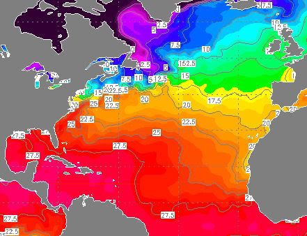
Inderdaad ja. Tussen de 27 en 30 graden. De ideale temperaturen voor orkanen.quote:Op zondag 10 juni 2007 16:21 schreef HurriTonie het volgende:
[afbeelding]
Zoals je ziet is de atlantische oceaan al best warm
kaartje
Tropical Depresion 3 is ontstaan in de oostelijke pacific.
Waarschijnlijk wordt het net een tropische storm en gaat dan weer uitwaaien
INITIAL 11/1600Z 15.7N 110.7W 30 KT
12HR VT 12/0000Z 16.2N 111.6W 35 KT
24HR VT 12/1200Z 17.1N 112.8W 35 KT
36HR VT 13/0000Z 17.7N 114.1W 30 KT
48HR VT 13/1200Z 17.7N 115.5W 25 KT...DISSIPATING
72HR VT 14/1200Z 17.5N 117.5W 20 KT...REMNANT LOW
96HR VT 15/1200Z...DISSIPATED
quote:MetOffice verwacht geen actief orkaanseizoen
Kwamen eerder Amerikaanse onderzoekers met prognoses voor een actief Atlantisch orkaanseizoen 2007, het Engelse MetOffice verwacht een seizoen met een iets minder dan gemiddeld aantal tropische stormen.
Volgens MetOffice is er 70% kans dat er in de periode juli t/m november 7 tot 13 tropische stormen gaan voorkomen, met als meest waarschijnlijke uitkomst 10. Het gemiddeld aantal stormen over deze maanden gedurende 1990-2005 bedroeg 12,4.
Het MetOffice gebruikt voor haar verwachting het zogenaamde GloSea model, ontwikkeld in samenwerking met het ECMWF. Dit is een dynamisch model dat gebruik maakt van de kennis over natuurkundige processen die een rol spelen bij het voorkomen van tropische systemen. De Amerikanen daarentegen gebruiken tot nog toe een statistisch model, dat uitgaat van in het verleden waargenomen correlaties tussen het aantal stormen en externe factoren. Het GloSea model scoorde vorig jaar ook goed, in tegenstelling tot de Amerikaanse prognoses. Die laatste verwachtten na een recordactief 2005 ook een bovengemiddeld actief 2006 seizoen. In werkelijkheid werd een heel gemiddeld Atlantisch orkaanseizoen.
In het huidige seizoen zijn tot nu toe twee (sub)tropische stormen voorgekomen, Andrea en Barry. Deze tellen echter niet mee voor de Engelse prognose, die vanaf juli telt.
Zie verder: link

Tropical Storm 03Bquote:Two areas of concern
Both the Atlantic and Pacific basins remain void of any tropical activity, and no tropical formation is expected in the near term.
This said, an area of showers and thunderstorms affecting northeast Nicaragua and the western Caribbean will clip eastern Honduras later today. While this convection is not associated with any area of low pressure, the tropical moisture will surge northward across the Yucatan and into the Gulf of Mexico this weekend. It is possible that by early next week, this tropical moisture will make it into some pasts of the southern United States.
Meanwhile, a newly formed tropical cyclone in the Indian Ocean could cross southern India and enter the Arabian Sea this weekend.
Groot complex is dit. Het kan India oversteken en daarna in de Arabische Zee terecht komen, waar het zich misschien ontwikkeld tot een orkaan.
[ Bericht 6% gewijzigd door #ANONIEM op 21-06-2007 21:08:29 ]
inderdaadquote:Op vrijdag 22 juni 2007 12:47 schreef Party_P het volgende:
Tjeem daar kan Nederland heeeeel erg vaak in, in die wolkencomplexen
In Zuid-India zijn zeker 45 mensen om het leven gekomen door een tropische storm en hevige regen. Delen van de stad Nandyal staan onder water. Ruim 56.000 mensen moesten hun huis uit. Ook in het zuiden van China valt veel regen.
NOS
NOS
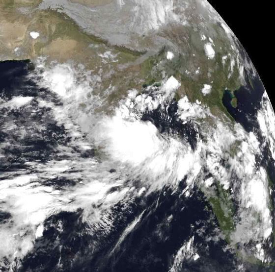
Nieuwe tropische cycloon boven Arabische Zee
De tropische cycloon 03B, die vorige week ontstond ten oosten van India boven de Golf van Bengalen, is inmiddels ten westen van India aangekomen en is opnieuw tot cycloonkracht aangesterkt boven de Arabische Zee.
Cycloon 3B koerst naar het westnoordwesten en zal nog iets kunnen aansterken. Het systeem zal waarschijnlijk dinsdagavond in het uiterste zuidoosten van Iran aan land komen, dicht bij de grens met Pakistan.
Tijdens de overtocht over India was het systeem drastisch afgezwakt en geen cycloon meer. Toch waren de restanten de afgelopen dagen mede debet aan de zware buien die in India en het zuiden van Pakistan honderden mensenlevens hebben gekost.

Tropical Cyclone 03B
Cyclonic storms in the Arabian Sea are rare, but not unheard of. Two tropical cyclones in the space of a month, on the other hand, is quite rare indeed. Unlike its predecessor, Tropical Cyclone Gonu, Cyclone 03B originated on the opposite side of the Indian Peninsula in the Bay of Bengal. At 11:10 a.m. local time (06:10 UTC) on June 25, 2007, when the Moderate Resolution Imaging Spectroradiometer (MODIS) on NASA’s Terra satellite captured this image, Tropical Cyclone 03B was reforming in the Arabian Sea south of the Pakistan coast after having crossed over India. The storm system has a discernable spiraling shape, but does not appear well-formed in this image. The storm has no distinct eye, suggesting that it is not particularly well organized. At the time, sustained winds were measured at 60 kilometers per hour (40 miles per hour) according to the University of Hawaii’s Tropical Storm Information Center.
The storm flooded India’s Andhra Pradesh province, resulting in 45 deaths, according to Weather Underground. It also caused flooding and wind damage in Karachi, Pakistan, where the death toll was around 200, according to BBC News. After crossing land, the storm reached the Arabian Sea and began to reform. As of June 26, forecasts were calling for the storm to gain some organization and power, skirt the Pakistani coast, and make landfall again somewhere near the border between Iran and Pakistan. Storm surge from Cyclone 03B was predicted to be moderately high, even though the storm is not strong, since the offshore waters are shallow, similar to the northern Gulf of Mexico. Because these kinds of storms are rare, coastal communities are particularly vulnerable to storm surge damage.
Doden in Pakistan door cycloon Yemyin
(Novum/AP) - De cycloon Yemyin, die dinsdag toesloeg in het kustgebied van de Pakistaanse provincie Baluchistan, heeft tot dusverre aan zeker twaalf mensen, onder wie vier kinderen, het leven gekost. Duizenden mensen zijn op de vlucht voor het door de storm voortrazende water vast komen te zitten op de daken van huizen en in de toppen van bomen.
Schepen en helikopters van de marine hebben rond de 125 opvarenden van door de storm overvallen schepen gered. Een onbekend aantal opvarenden wordt nog vermist. Dit hebben de autoriteiten woensdag bekendgemaakt. (nieuws.nl)
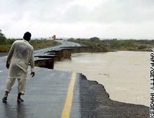
10 drown as cyclone hits Pakistan
A Pakistani man looks at the washed away Coastal Highway hit by Cyclone Yemyin at Aghor Tuesday.
QUETTA, Pakistan (AP) -- Ten people drowned and thousands fled to higher ground as a tropical cyclone lashed Pakistan's coastline with heavy rains and high winds, officials said.
Navy ships rescued 75 people from four floundering vessels Tuesday and were searching for more boats caught in the rough seas with the help of helicopters, said Navy spokesman Lt. Com. Salman Ali.
Cyclone Yemyin hit parts of the coastline of Baluchistan province at about noon with winds of up to 57 miles (91 kilometers) an hour, said Qamaruz Zaman, director-general of the Pakistan Meteorological Department.
Rain-swollen rivers flooded several coastal districts, killing at least 10 people, including four children, said Raziq Bugti, spokesman for the provincial government.
Floods washed away some bridges and part of the main coastal highway, causing lengthy traffic delays. Hundreds of villagers clutching possessions filed past the vehicles in the opposite direction.
In the hills, spillways were opened to release the water pressure on two dangerously full dams, Bugti said.
Relief efforts were hampered with roads and telephone lines severed in nine districts of the province.
Officials said the storm's intensity was decreasing and would subside by evening, but not before dumping heavy rains that could last through the night.
04b
There continue to be no signs of tropical cyclone development in the Atlantic and Pacific Basins. While occasional clusters of thunderstorms do flare up, upper-level winds in the areas favorable for late June development (the Gulf of Mexico, the western Caribbean Sea, the southwest north Atlantic and the Pacific south of Mexico) are too strong to allow any tropical development.
However, an upper low and a tropical wave are bringing locally heavy rainfall to the Bahamas and increasingly to the Florida Peninsula, as tropical moisture increases over that area.
A tropical cyclone with tropical storm strength winds in the Bay of Bengal will move into India, producing another flooding rain event.
bron

Er is een nieuwe storm ontstaan.
Tot nu toe heet hij 04W. Het lijkt een behoorlijk zware storm te worden !
Tot nu toe heet hij 04W. Het lijkt een behoorlijk zware storm te worden !


Ziet er indrukwekkend uit.quote:Op zaterdag 7 juli 2007 16:26 schreef DForce het volgende:
Er is een nieuwe storm ontstaan.
Tot nu toe heet hij 04W. Het lijkt een behoorlijk zware storm te worden !
[afbeelding]
[afbeelding]
Gaat zeker een categorie 1 worden en missichien wel meer.
foto van 15.00 uur 7 juli 2007

Volgens de laatste voorspellingen gaat het een catogorie 4 worden !
En hij lijkt tot nu toe richting de Chineese kust te gaan !
En hij lijkt tot nu toe richting de Chineese kust te gaan !
In de gaten houden dan maar
Doe mee met het voorspellen van het weer!
Weekvoorspelling | Week 12 (invullen tot 16-03 - 11:59)
Maandvoorspelling Maart (Inzendingen gesloten)
Jaarvoorspelling 2025 / 2026
Weekvoorspelling | Week 12 (invullen tot 16-03 - 11:59)
Maandvoorspelling Maart (Inzendingen gesloten)
Jaarvoorspelling 2025 / 2026
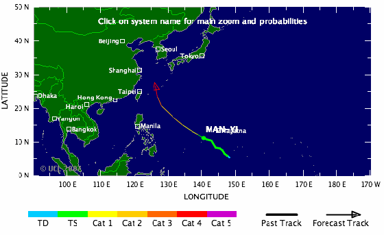
quote:Rather large Tropical Storm Man-Yi (65 mph) is expected to strengthen into a powerful typhoon in the western Pacific. Man-Yi, centered about 275 miles southwest of Guam, is forecast to reach typhoon strength within the next 12 hours.
The storm will move generally northwestward this week, and is predicted to crank up to a 145-mph monster by Friday (U. S. time). By then, Man-Yi could be doing some saber rattling aimed at either Taiwan or Okinawa.
Closer to home, a large low pressure area moving northwestward about 675 miles southwest of Cabo San Lucas, Mexico, still has the potential to develop into a tropical depression over the next day or two. After that, it will encounter a less favorable environment for strengthening.
The tropical Atlantic Basin, meanwhile, remains quiet.
Deze gaat voor veel ellende zorgen
In de East Pacific is een Depressie ontstaan !!
Heel mischien wordt het nog een minimaale tropische storm !!
Niet erg heftig dus ...
Heel mischien wordt het nog een minimaale tropische storm !!


Niet erg heftig dus ...
Tropische storm Man-Yi is dinsdagochtend uitgegroeid tot een volwaardige tyfoon. Dinsdagochtend om 08.00 uur bereikte Man-Yi windsnelheden van 120 kilometer per uur en werden er windstoten van 148 kilometer per uur.
Woensdagnacht om 02.00 bereikte de tyfoon windsnelheden van 148 kilometer per uur met windstoten tot 185 kilometer per uur. Woensdag ligt de tyfoon op open zee en neemt dan nog in kracht toe.
De verwachting is dat Man-Yi zich donderdag ontwikkelt tot een krachtige tyfoon. Hij beweegt zich met 24 kilometer per uur naar het noordwesten. Naar verwachting buigt de storm vrijdag af naar het noord-noordoosten en zal Taiwan schampen. Daarna zal de tyfoon recht afstevenen op de Riukiu eilanden en Japan.
weeronline

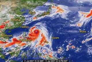
Kan voor Japan nog wel een probleem gaan opleveren idd... ziet er weer 'rood' uit daar op het kaartje
ik zit momenteel in Taiwan... 2 dagen geleden nog lichte zorgen omdat er een kans was dat deze Taiwan als een cat4 ging hitten... Echter buigt deze nu af en gaat bijna zeker Okinawa vol raken als cat 4.......quote:Op woensdag 11 juli 2007 13:21 schreef aloa het volgende:
Tropische storm Man-Yi is dinsdagochtend uitgegroeid tot een volwaardige tyfoon. Dinsdagochtend om 08.00 uur bereikte Man-Yi windsnelheden van 120 kilometer per uur en werden er windstoten van 148 kilometer per uur.
Woensdagnacht om 02.00 bereikte de tyfoon windsnelheden van 148 kilometer per uur met windstoten tot 185 kilometer per uur. Woensdag ligt de tyfoon op open zee en neemt dan nog in kracht toe.
De verwachting is dat Man-Yi zich donderdag ontwikkelt tot een krachtige tyfoon. Hij beweegt zich met 24 kilometer per uur naar het noordwesten. Naar verwachting buigt de storm vrijdag af naar het noord-noordoosten en zal Taiwan schampen. Daarna zal de tyfoon recht afstevenen op de Riukiu eilanden en Japan.
weeronline
Totaal Travel 04-24: 87 reizen, 151 vliegtickets, 58 landen, 6 continenten, 949 reisdagen, 163.804 foto's
Mijn reisfotos!
Mijn reisfotos!
Okinawa wordt vol getroffen.quote:Op woensdag 11 juli 2007 17:30 schreef ETA het volgende:
[..]
ik zit momenteel in Taiwan... 2 dagen geleden nog lichte zorgen omdat er een kans was dat deze Taiwan als een cat4 ging hitten... Echter buigt deze nu af en gaat bijna zeker Okinawa vol raken als cat 4.......
Foto van 15.00 uur vandaag.
Groot oog heeft deze orkaan
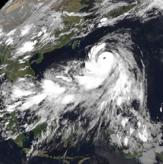
Ik denk dat taiwan nog wel de nodige neerslag krijgt.
Ja zeg doe me een lol......dit is 1 van de weinige topics die tenminste goed info bevat en waar zeer weinig wordt gechat....wees eens blij voor de users die dit bij houden! Petje af voor jullie
Doe mee met het voorspellen van het weer!
Weekvoorspelling | Week 12 (invullen tot 16-03 - 11:59)
Maandvoorspelling Maart (Inzendingen gesloten)
Jaarvoorspelling 2025 / 2026
Weekvoorspelling | Week 12 (invullen tot 16-03 - 11:59)
Maandvoorspelling Maart (Inzendingen gesloten)
Jaarvoorspelling 2025 / 2026

Mischien gaat het kwa regen wel meevallen maar met de wind zeker niet.
windsnelheden : 231km per uur
windvlagen : 278km per uur
Het zou mijn niet verbazen als Man-Yi ook nog een catogorie 5 wordt.
windsnelheden : 231km per uur
windvlagen : 278km per uur
Het zou mijn niet verbazen als Man-Yi ook nog een catogorie 5 wordt.
Idd. GFS onderschat het een beetje .quote:Op donderdag 12 juli 2007 00:32 schreef DForce het volgende:
Mischien gaat het kwa regen wel meevallen maar met de wind zeker niet.
windsnelheden : 231km per uur
windvlagen : 278km per uur
Het zou mijn niet verbazen als Man-Yi ook nog een catogorie 5 wordt.
Op google.com komen de eerste nieuwsberichten ook al binnen.
quote:Man-Yi Strengthens Into Category Four Storm, Heads Toward Japan
Bron : Bloomberg
July 12 (Bloomberg) -- Typhoon Man-Yi strengthened into a Category Four storm with maximum sustained winds of 212 kilometers per hour (132 miles an hour) in the Pacific Ocean as it headed for Okinawa in Japan, U.S. Navy forecasters said.
The center of Man-Yi, the fourth named storm of this year's western Pacific cyclone season, was 751 kilometers south- southeast of Naha, on the island of Okinawa, at 3 a.m. Japan time today, the latest advisory on the U.S. Navy Joint Typhoon Warning Center's Web site said.
Japan is regularly buffeted by tropical cyclones during the northern hemisphere's summer and nine people died when Kyushu was hit by Typhoon Shanshan in September last year. A record 10 tropical storms and typhoons hit the country in 2004, killing more than 60 people and causing billions of dollars of damages.
Man-Yi was moving northwest at 31 kilometers an hour and the storm is forecast to turn more to the north before passing over Okinawa late today or early tomorrow. By then, forecasters expect its maximum sustained winds to reach 230 kilometers an hour.
The storm's winds were gusting to 258 kilometers per hour near its center and typhoon-strength winds of 118 kilometers an hour extend out 101 kilometers from the eye, the Navy said. Waves are as high as 9.5 meters (31 feet) near Man-Yi's center.
The eye of Man-Yi is expected to cross Okinawa and swing northeast, skirting the southern coasts of Kyushu, Shukoku and western Honshu before passing over Tokyo in the early hours of July 15. By then, the storm is expected to weaken, with winds slowing to 138 kilometers per hour.
The typhoon is a Category Four storm, the second-strongest on the five-step Saffir-Simpson scale.
Man-Yi is the name of an old strait in Hong Kong that was dammed and turned into a reservoir, according to the Web site of the Hong Kong Observatory, which lists cyclone names in use in the Pacific.
Windspeeds of Tyfoon Man-Yi
Typhoon Man-yi formed as a tropical depression in the western Pacific on July 8, 2007, among the islands of Micronesia. The storm gradually built power to typhoon status on July 10. As of July 11, forecasters were calling for Man-Yi to strengthen to Category 4 (Super Typhoon) status, with sustained winds in the storm’s core predicted to reach at least 210 kilometer per hour (131 miles per hour).
This data visualization of the storm shows observations form the QuikSCAT satellite on July 9, 2007, at 20:58 UTC (8:58 a.m. local time, July 10). At this time, Man-Yi appeared as a well-developed storm system, but had not yet reached typhoon status; it’s peak winds were around 110 km/hr (65 mph; 60 knots). The image depicts wind speed in color and wind direction with small barbs. White barbs point to areas of heavy rain.
QuikSCAT measurements of the wind strength of Man-Yi and other tropical cyclones can be slower than actual wind speeds. QuikSCAT’s scatterometer sends pulses of microwave energy through the atmosphere to the ocean surface and measures the energy that bounces back from the wind-roughened surface. The energy of the microwave pulses changes depending on wind speed and direction.
To relate the radar signal to actual wind speed, scientists compare measurements taken from buoys and other ground stations to data the satellite acquired at the same time and place. Because the high wind speeds generated by cyclones are rare, scientists do not have corresponding ground information to know how to translate data from the satellite for wind speeds above 50 knots (about 93 km/hr or 58 mph).
Also, the unusually heavy rain found in a cyclone distorts the microwave pulses in a number of ways, making a conversion to exact wind speed difficult. Instead, the scatterometer provides a nice picture of the relative wind speeds within the storm and shows wind direction.