WKN Weer, Klimaat en Natuurrampen
Lees alles over het onstuimige weer op onze planeet, volg orkanen en tornado's, zie hoe vulkanen uitbarsten en hoe Moeder Aarde beeft bij een aardbeving. Alles over de verwoestende kracht van onze planeet en tal van andere natuurverschijnselen.


Hier is dan het eerste deel van Hurricane Season 2009 voor alle tropische stormen ter wereld. Voor zowel Atlantische, Indische als Pacifische stormen kan je hier terecht
Algemene Info
Met de term 'Hurricane Season' bedoelden we in eerste instante de periode van 1 juni tot 30 november.
Deze periode wordt in het Atlantische basin en de Golf van Mexico gezien als het Stormen-seizoen. Echter komen deze geweldadige stormen overal in de wereld voor en met name in Azië zorgen ze jaarlijks voor duizenden slachtoffers en tienduizenden daklozen. Echter horen we vaak erg weinig over de stormen in Azië en juist meer over die in de VS.
In de laatste jaren zijn Tropische Stormen meer en meer in de media gekomen. Het lijkt ook alsof ze meer en meer slachtoffers maken. Een documentaire over Hurricane Andrew uit 1992, heeft diepe indruk gemaakt en ook zullen kenners orkanen Floyd, Gilbert, Stan en Ivan zich zeker nog herinneren. De catastrofe die "Katrina" met zich meebracht ging de hele wereld over. En dan praten we eigenlijk alleen over de Atlantische stormen en lijken we te vergeten dat er in 2007 meer dan 4000 doden vielen in Bangladesh door orkaan Sidr en orkaan Nargis zorgde voor 80.000 doden in Myanmar alleen al.
Hoewel het Atlantische seizoen pas officieel in juni begint zijn er op andere plekken in de wereld zeker meer orkanen te vinden in de komende maanden. We zullen ook deze dus zeker gaan bespreken. Waarschijnlijk zal de kern van de discussie en de posts gaan over de periode 1-6-2008 t/m 30-11-2008. T.z.t. zal er ook wel een NWS-topic worden geopend als een orkaan ook uitgebreid in het nieuws komt.
Orkanen: Hoe ontstaan ze eigenlijk?
op de site van Wikipedia kan je in het Nederlands nalezen hoe ze ontstaan en wat de belangrijkste energiebron is voor hun verwoestende kracht: het warme zeewater
Ook de BBC heeft er een interessante en leuke animatie over gemaakt.
Ook wordt er op LiveScience in het engels prima uitgelegd hoe ze ontstaan en zich ontwikkelen
Indeling en Kracht
De stormen worden ingedeeld op 'categorie'. Vaak zijn het eerst tropische stormen" (Tropical Depression, Tropical Storms), die overgaan op Orkaanstatus (Hurricane/Tyfoons) Ze worden ingedeeld op windsnelheden via de Saffir-Simpson Schaal
Tropical Depression 24-38 mph winds (38-61 km/u)
Tropical Storm 39-73 mph winds (62-118 km/u)
Hurricane Categorie 1 74-95 mph winds (119-153 km/u) -- 4/5 ft Storm Surge -- Vb. Danny 1997, Stan 2005
Hurricane Categorie 2 96-110 mph winds (154-177 km/u) - 6/8 ft Storm Surge -- Vb. Danielle 2004
Hurricane Categorie 3 111-130 mph winds (178-209 km/u) - 9/12 ft Storm Surge - Vb.Fran 1996, Beta 2005
Hurricane Categorie 4 131-155 mph winds (210-249 km/u) - 13/18 ft Storm Surge - Vb.Hugo 1989, Frances 2004
Hurricane Categorie 5 > 156 mph winds (meer dan 250 km/u) -- 18ft or more S.S. -- Vb.Andrew 1992, Mitch 1998 en Wilma, Katrina 2005
TIP: Interactief (film0overzicht van de krachten van orkanen nav de schaal van Simpson
Waarom hebben orkanen namen?
De Tropische Depressies worden overal ter wereld in de gaten gehouden en zodra de depressies uitgroeien tot orkaan of cycloon, wordt er een naam aan de storm gegeven. Sinds 1950 krijgen ze namen op alfabetische volgorde (met uitzondering van de letters Q, U, X, Y en Z). Mocht een orkaan vernietigend hebben huisgehouden zoals Floyd, Gilbert en bijv. Katrina, dan zal die naam worden vervangen. Soms komt het ook voor dat alle letters van het alfabet gebruikt zijn in één seizoen (zoals 2005), dan zal een volgende storm Alpha gaan heten, gevolgd door Beta etc etc. Voor het orkanenseizoen 2009 zijn de namen als volgt:
Atlantische Stormen 2009
Ana, Bill, Claudette, Danny, Erika, Fred, Grace, Henri, Ida, Joaquin, Kate, Larry, Mindy, Nicholas, Odette, Peter, Rose, Sam, Teresa, Victor, Wanda
In het Noordoosten van de pacific ontstaan ook orkanen. Deze zorgen meestal voor weinig schade aan de Amerikaanse/Mexicaanse westkust.
Oost Pacifische Stormen 2009
Andres, Blanca, Carlos, Dolores, Enrique, Felicia, Guillermo, Hilda, Ignacio, Jimena, Kevin, Linda, Marty, Nora, Olaf, Patricia, Rick, Sandra, Terry, Vivian, Waldo, Xina, York, Zelda
Verder zijn er dan nog de stormen in het Noorden, Zuiden en Westen van de Pacific. Daar worden ze tyfoons en/of cyclonen genoemd. Met name de stormen in het Noord/Westen komen vaak in het nieuws omdat ze Japan, de Filipijnen, Taiwan en China vaak teisteren, maar ook geheel Zuid Oost Azie kunnen treffen. Meer informatie over de namen van deze stormenvind je hier.
Leuk hoor, maar wanneer zijn die orkaanseizoenen nou precies?
ATLANTISCHE OCEAAN: 1 juni t/m 30 november
NOORD OOST PACIFIC:Begin mei t/m begin November, met piek in Augustus/September
NOORD WEST PACIFIC: Begin juli t/m eind November, maar eigenlijk hele jaar door aktiviteit.
NOORD INDISCHE OCEAAN: April t/m December met pieken in Mei en November
ZUID INDISCHE + WEST AUSTRALISCHE OCEAAN: Oktober t/m Mei met pieken in Februari en April
ZUID WEST PACIFIC + OOST AUSTRALISCHE OCEAAN: Oktober tot eind April met piek in Februari.
Over het algemeen is Mei de rustigste maand en September de zwaarste.
Ennuh, hoe ziet die voorspelling er voor 2009 dan uit?
50 jaar Hurricane Seizoen hebben een gemiddeld orkaanseizoen gecreëerd. 9,6 stormen krijgen een naam, 5,9 stormen groeien uit tot orkaan en 2,3 orkanen worden superorkanen.(cat 4/5)
Volgens Phil Klotzbach en William Gray van CSU wordt 2009 een relatief druk orkaanseizoen. Volgens hun is er 63 procent kans dat een superorkaan in 2009 de VS kust zal treffen. Meer over de voorspelling voor 2009 en die van 2008 kan je hier lezen
Oude Delen
2004 - Deel 1 en Deel 2
2005 - Deel 1 en Deel 2
2006 - Deel 1 en Deel 2
2007 - Deel 1, Deel 2, Deel 3 en Deel 4
2008 - Deel 1 en Deel 2
Enkele Links
1. National Hurricane Centre
2. Carribean Storm Network
3. Hurricanezone
4. Hurricane Track
5. Website met satelietbeelden van de Caribbean en de rest van Amerika
6. Intellicast: Geavanceerde satellietfoto's en gifs van aktuele stormen
7. Tropical Weather Underground
8. Tropical Storm Risico's van dit moment
9. Wikipedia Hurricanes/Tyfonen in het algemeen
10. Alle stormen ter wereld van de laatste jaren in overzicht
11. The StormTrack
12. Orkanensite in de Filipijnen
13. Atlantische Orkanensite
14. Actuele orkanen in Australië en De orkaanindeling in Australië
15. Tropische weersite omgeving Australië
16. Mooie site over Orkanen aan de VS kusten
17. Website van NASA over Hurricanes
Opmerkelijke Wikipedia-Links
-- Hurricane Katrina 2005
-- Cyclone Nargis 2008
-- Hurricane Season 2008 - Wikipedia
-- Hurricane Season 2007 - Wikipedia
-- Hurricane Season 2006 - Wikipedia
-- Hurricane Season 2005 - Wikipedia
-- Hurricane Season 2004 - Wikipedia
Actuele Weerradar in Golf van Mexico

Actuele Water temperatuur.
=====================
Post hier je gegevens, berichten, data en opmerkelijke zaken over Orkanen, Tyfoons en Hurricanes en van 2009
[ Bericht 0% gewijzigd door Frutsel op 27-08-2009 12:10:19 ]

Nu wel, thxquote:Op maandag 12 januari 2009 22:49 schreef aloa het volgende:
Staat deze site er ook tussen?
Current Tropical Cyclones Australie
Onderstaande link is ook wel handig. In Australie gebruiken ze weer een andere indeling, dan in Amerika of Azie.
categorie/indeling
categorie/indeling

Madagascar wordt weer flink blank gezet
twee van die krengen
[ Bericht 26% gewijzigd door Frutsel op 19-01-2009 15:05:57 ]
Veel schade in Madagascar door Fanele.
Overstromingen en enorme stormschade.
Overstromingen en enorme stormschade.
quote:TROPICAL STORM "ERIC"
Tropical storm "Eric" descended on the regions of Sofia, Sava, Atsinanana, and Analanjirofo in the north-east of Madagascar at 8 am on 19 January 2009, carrying heavy rain and winds at the speed of up to 95 km/h. Landing in the district of Fenerive-Est, "Eric" edged southwards through the districts of Fenoarivo Atsinanana, Sainte-Marie, Vavatenina, Ambositra, Toamasina I, Antsohihy, Mampikony, and Mandritsara,veering off into the Indian Ocean by 2 pm.
According to the preliminary reports received from regional authorities through BNGRC, approximately 1,000 persons remain homeless with another 1,700 persons impacted to varying degrees by the tropical system. BNGRC reports one person dead and 24 injured
Unconfirmed damage has been reported in the agricultural sector: flooded rice paddies, fallen banana trees, destroyed manioc plantations and other vital crops. Some stretches of national roads have been flooded by swollen rivers, making communication difficult and in some cases suspended. Several public buildings, including schools, have been reported damaged to varying degrees.
CYCLONE "FANELE"
Fanele was a type 4 cyclone, descending on the south-east of Madagascar at 4 am on 21 January 2009. Moving through the district of Morondava, some 50 km south of the town of Morondava, the system brought in winds travelling at 150 km/h, reaching in gusts the speed of 210 km/h. Later that day, "Eric" moved south-east, crossing the regions of Menabe, Atsimo-Andrefana, Haute Matsiatra, and Ihorombe, exiting Madagascar on 22 January at 2 am through the regions of Anosy and Atsimo Atsinanana. The arrival of the cyclone was preceded by heavy rainfall threatening the inhabitants of the town of Morondava and the district of Miandrivazo with the prospect of flooding.
Preliminary reports issued by BNGRC's mobile teams dispatched to the impact areas point to over 9,000 persons displaced in the district of Miandrivazo due to flooding. A number of public buildings in the town of Morondava have suffered varying degrees of damage, including the municipal water system which has been reported down. Homeless persons are being assembled in temporary shelter areas under the supervision of the Malagasy Red Cross.
As rapid assessment missions are being dispatched to the impacted areas, more accurate picture of the extent of damage will become available in the next days.
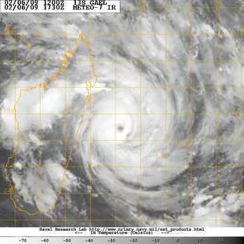

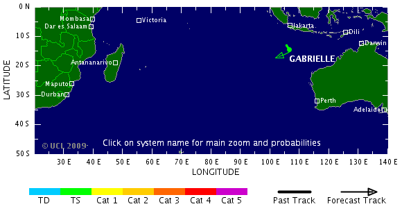
Tropical Cyclone Gael
Tropical Cyclone Gael brushed the islands of Mauritius and Réunion on its westward trek through the southern Indian Ocean in early February 2009. On February 7, the storm hit Category 4 cyclone strength, with sustained winds of 120 knots (138 miles per hour), as it approached the east coast of Madagascar. This image from the Moderate Resolution Imaging Spectroradiometer (MODIS) on NASA’s Terra satellite shows the storm that day, before it veered away from land and headed northeast.

Tropical Cyclone Gael brushed the islands of Mauritius and Réunion on its westward trek through the southern Indian Ocean in early February 2009. On February 7, the storm hit Category 4 cyclone strength, with sustained winds of 120 knots (138 miles per hour), as it approached the east coast of Madagascar. This image from the Moderate Resolution Imaging Spectroradiometer (MODIS) on NASA’s Terra satellite shows the storm that day, before it veered away from land and headed northeast.
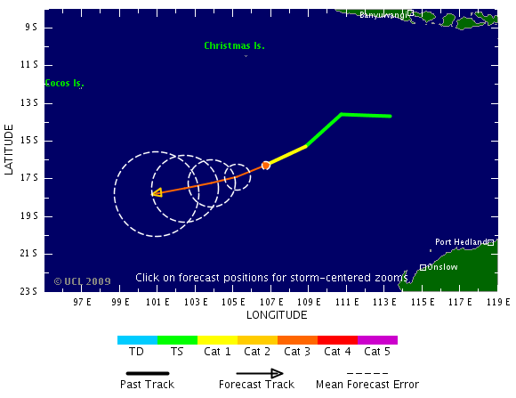
Inmiddels is Hamish een categorie 4
(volgens de schaal in Australie een cat 5)
(volgens de schaal in Australie een cat 5)
quote:Brutal winds as Hamish reaches Cat 5
Cyclone Hamish has now intensified into a Category 5 system, creating winds in excess of 280 kilometres an hour, off the north-east coast of Queensland.
Residents and tourists are preparing to ride out the effects of the cyclone as it moves along the coast.
The outer edge of the massive storm, already 40km/h faster than Cyclone Larry which smashed Innisfail in 2006, will lash islands in the Whitsundays in the next few hours.
It continues moving south-east off the coast, and some islands in its path have been evacuated.
A Category 5 is rated as extremely dangerous and can cause widespread destruction.
Director of the Bureau of Meteorology, Jim Davidson, says the cyclone will bring winds up to 180 kilometres an hour to islands in the Whitsundays.
"If it comes a little closer the damage will be much worse," he said.
Mr Davidson says it will stay at least 200 kilometres off the coast.
"And even if a Category 5 cyclone is that far out, it shouldn't be a serious problem," he said.
Emergency warning signals have been sounded in communities from Bowen to Mackay, but the biggest concern is for islands in the Whitsundays.
Gold Coast man Dan Riddle is on his honeymoon on Hamilton Island, and he and his wife have stocked up on food and water.
"We don't really know what to expect but I guess a heap of rain and bit of wind," he said.
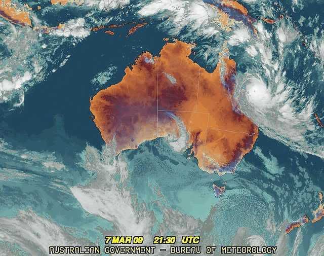
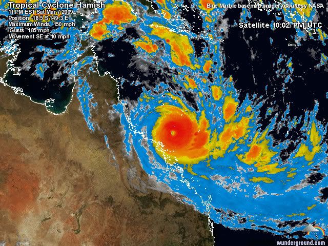

quote:With winds near 130 knots (150 miles per hour), Tropical Cyclone Hamish was a powerful Category 4 storm (on the Saffir-Simpson Scale) as it paralleled the northeast coast of Australia at the end of the first week of March 2009. Initial predictions were that the storm would weaken and come ashore just north of Brisbane on March 9, but instead, the storm veered more east than south, drawing the eye of the still-powerful storm away from land.
This image of Hamish was captured by the Moderate Resolution Imaging Spectroradiometer (MODIS) on NASA’s Aqua satellite on March 9, 2009 at 3:30 Universal Time Coordinated. The storm was compact, with a ring of towering of thunderclouds surrounding the cloud-filled eye. A few hours before this image was taken, Hamish had maximum sustained winds near 110 knots (127 mph), with gusts up to 135 knots (155 mph). Northwest of the storm, the waters around the Great Barrier Reef were bright turquoise, a sign that winds and waves had churned up sediment.
Although the risk of a direct landfall had lessened, the dangers from strong winds and flooding from heavy rainfall and storm surges remained. Thousands of residents of low-lying coastal communities north of Brisbane evacuated their homes, and forecasters warned that the storm’s path and intensity would remain uncertain until Wednesday.
Hamish is precies langs de oostkust van Australie gezakt. Steeds rond de 200 km uit de kust.
Er bestaat een kans dat ie toch nog landfall gaat maken.
Er bestaat een kans dat ie toch nog landfall gaat maken.
quote:"It's running into an upper jet stream that wants to rip the top off the cyclone and push it out to the east," he said.
"But the high in the Tasman with the easterly flow is trying to push the lower half of the cyclone back towards the coast.
"Now that's going to weaken the cyclone and it depends on how much it's weakened by that interaction as to how much is left of the system."
Authorities say the next 24 hours will be the crucial period to see if Hamish turns back closer to the coast.
Mike Shapland from Emergency Management Queensland says it remains unclear what the storm will do.
Mr Shapland says it appears the threat has eased for now but it remains unclear what the storm will do.
"I think we've got a fairly clear space for the next 24 to 48 hours if the bureaus track and estimations come right," he said.
"But really what happens after Wednesday is the question in our minds."

Minder actief hurricaneseizoen verwacht
quote:De eerste verwachtingen voor het Atlantisch orkaanseizoen zien er gunstig uit. In de Atlantische Oceaan en de Caribische Zee worden dit jaar minder tropische orkanen verwacht dan de afgelopen jaren.
Ook in de westelijke Stille Oceaan, dus voor de westkust van Mexico en de VS, worden dit jaar minder tropische cyclonen verwacht. Het Atlantisch orkaanseizoen duurt van juni tot december. De verwachting van de orkaanactiviteit is afkomstig van het Europees Weercentrum ECMWF en geldt voor de eerste helft van het seizoen.
Het geringere aantal tropische stormen en hurricanes hangt onder meer - en op een ingewikkelde manier - samen met La Niña. In een La Niña-jaar - met tijdens het hurricane-seizoen relatief koud zeewater langs de evenaar - ontstaan doorgaans meer hurricanes. Dat houdt verband met de wind op grote hoogte die dan minder sterk is, waardoor de enorme wolkencomplexen zich tot hoog in de atmosfeer kunnen ontwikkelen.
Het ziet er echter naar uit dat de La Niña van de afgelopen periode komende zomer verleden tijd is. Volgens de verwachtingen blijven de temperaturen langs de Afrikaanse westkust, waar de stormen ontstaan, echter voorlopig nog laag. Door dat naijleffect kunnen tropische stormen en hurricanes zich komende zomer moeilijker vormen.
Dat betekent niet dat er hier helemaal geen orkanen zullen langskomen. Normaal telt een seizoen tegenwoordig zo'n 12 tot 16 tropische stormen waarvan er 5 à 10 het orkaanstadium bereiken. Bovendien zeggen de prognoses niets over de schade die ze kunnen aanrichten. Op deze termijn is niet aan te geven hoeveel orkanen land bereiken en hoe zwaar ze worden.
Vorig jaar was bijzonder. In totaal ontstonden er 8 orkanen, waarvan er liefst 6 het vasteland van de Verenigde Staten bereikten, terwijl er 5 uitgroeiden tot een zware orkaan van de hoogste categorieën. Recordjaar is 2005 toen het Atlantisch gebied 14 hurricanes zag passeren.
Bron: KNMI (vwk)

Tropical Cyclone Ilsa was heading west-southwest in the Indian Ocean on March 20, 2009, when the Moderate Resolution Imaging Spectroradiometer (MODIS) on NASA’s Terra satellite captured this image. Ilsa reached Category 3 strength on March 19, but as of March 20, has weakened to Category 2.
Pff...al de zoveelste storm dit jaar die daar de boel lam legtquote:Op dinsdag 7 april 2009 15:08 schreef buachaille het volgende:
Tropische storm Jade heeft huisgehouden in Madagascar.
quote:2009 Atlantic Season prediction
MIAMI (Reuters) - The 2009 Atlantic hurricane season is likely to produce six hurricanes, the noted Colorado State University hurricane forecasting team said on Tuesday.
The storm research team founded by hurricane forecast pioneer William Gray said the six-month season beginning on June 1 would likely see 12 tropical storms and predicted that a weak El Nino event could form during that period.
El Nino, an unusual warming of water in the eastern Pacific Ocean, tends to diminish Atlantic hurricane activity by contributing to strong wind shear that can tear apart nascent storms.
The CSU team lowered its forecast from December, when it predicted the 2009 season would see 14 storms and seven hurricanes.
The 2008 Atlantic season was one of the busiest on record, with 16 tropical storms. Eight of those became hurricanes, with sustained winds of 74 mph or higher.
Last season spawned five hurricanes of Category 3 or higher. A record number of consecutive storms hit the United States.
But Cuba got the worst of last season's destruction. Three major hurricanes hit the Caribbean island, destroying or damaging nearly half a million homes, flattening sugar cane and tobacco fields and causing an estimated $10 billion damage.
The long-term average for the Atlantic hurricane season is about 10 tropical storms and six hurricanes. But experts said a period of heightened Atlantic hurricane activity started around 1995 and was expected to last 25 to 40 years.

quote:Tropical Storm Jade was coming ashore over Madagascar on April 6, 2009, when the Moderate Resolution Imaging Spectroradiometer (MODIS) on NASA’s Aqua satellite captured this photo-like image. The storm formed over the Indian Ocean on April 4, and briefly intensified into a Category 1 cyclone on April 5. The storm weakened before coming ashore. About the time that MODIS captured this image, Jade’s winds were decreasing from about 102 kilometers per hour (63 miles per hour or 55 knots) to 93 km/hr (58 mph or 50 knots).

Oh oh
Hopelijk wint Bijli niet veel meer aan kracht want ik weet vorig jaar nog wel toen Nargis van Birma een zwembad maakte en er 200,000 doden vielen
Hopelijk wint Bijli niet veel meer aan kracht want ik weet vorig jaar nog wel toen Nargis van Birma een zwembad maakte en er 200,000 doden vielen
Bijli is nog steeds een tropische storm. Maar dat was destijds ook zo met Nargis. En die kwam toch uiteindelijk tot een categorie4.
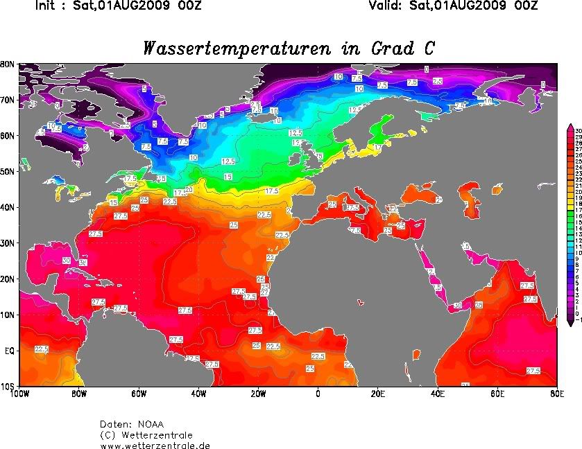
Temperatuur van het water ligt daar rond de 30 graden.
Temperatuur van het water ligt daar rond de 30 graden.
Bangladesh is getroffen door een cycloon.
De kust van Bangladesh is getroffen door een cycloon. Meer dan 200.000 kustbewoners zijn geëvacueerd. Er is veel schade, maar over slachtoffers is nog niets bekend. Bangladesh wordt ieder jaar geteisterd door wervelstormen. Eind 2007 kwamen in Bangladesh 3500 mensen om door de cycloon Sidr.
Bron: Teletekst.
quote:Bangladesh ports reopen after storm crosses coast
Source: Reuters
DHAKA, April 18 (Reuters) - Bangladesh authorities reopened ports on Saturday and hundreds of thousands of people headed home after a cyclonic storm crossed the coast causing less damage than feared, officials said.
The storm, with winds of up to 120 kph (75mph), swept over at least a dozen coastal districts and several offshore islands. Three people were killed in Cox's Bazar and thousands of thatched homes flattened and power supply disrupted.
"Ships sent out of jetties are coming back as normal operations have resumed this morning," an official at the main Chittagong port said.
Disaster management officials said more than three million people evacuated to shelters in Chittagong and Cox's Bazar were returning to their homes.
They said the loss to life and property was minimal because of adequate preparations by the disaster management ministry, the Red Crescent society and other groups experienced in evacuation and rescue efforts.
Storms and cyclones batter Bangladesh almost every year, killing many people and causing huge damage to crops and property.
A devastating cyclone in April 1991 killed around 140,000 people, while Cyclone Sidr swept part of the coast in November 2007 killing around 3,500.
Nasa voorspelt route van cyclonen
Onderzoekers van de Amerikaanse ruimtevaartorganisatie Nasa hebben een veelbelovende nieuwe methode ontwikkeld om de route van cyclonen te voorspellen. Daardoor kan de bevolking in de regio sneller gewaarschuwd en beter geïnformeerd worden.
De aanleiding voor de nieuwe methode was de ongemeen dodelijke cycloon Nargis in mei 2008. Nargis bezorgde wetenschappers hoofdbrekens omdat iedereen voorspeld had dat de cycloon Bangladesh zou treffen. In plaats daarvan week de storm plots scherp af naar het oosten, waar hij in Myanmar meer dan honderdduizend doden eiste.
De wetenschappers namen Nargis als proefkonijn en onderzochten al hun data en voorspellingen opnieuw. Daarvoor gebruikten ze de informatie van Nasa-satellieten, boeien op de oceanen, vliegtuigen en meetstations op land en in de lucht. Ze kwamen tot een nieuw model dat sneller en accurate de route van de cycloon kan voorspelen.
Volgens de onderzoekers is de nieuwe methode bruikbaar voor het nauwkeuriger voorspellen van cyclonen in de Indische Oceaan en in de Golf van Bengalen.
Vooral in die golf is het moeilijk om de route te voorspellen, omdat de kleine oppervlakte en het relatief ondiepe water ervoor zorgen dat een orkaan veel sneller beweegt, waardoor er minder tijd is om de route te voorspellen en de bevolking te waarschuwen.
vwk
[ Bericht 0% gewijzigd door #ANONIEM op 19-04-2009 20:59:57 ]


quote:Tropical Cyclone Bijli came ashore over eastern Bangladesh on April 17, 2009. The storm caused little damage, according to news reports, but did dump heavy rain on Bangladesh and neighboring Burma (Myanmar). This image, made with data captured by the Tropical Rainfall Measuring Mission (TRMM) satellite on April 17, shows the rainfall associated with the storm.
As much as 50 millimeters of rain fell per hour in the regions where rainfall was heaviest, shown in red. Outside the area of concentrated heavy rain, the rainfall was relatively light, as shown by the wide field of blue. The measurements shown in this image are from a variety of sensors on the TRMM satellite. Rain rates in the center of the swath (lighter area) are from the TRMM Precipitation Radar, the first precipitation radar in space, and those in the outer part of the swath are from the TRMM Microwave Imager. The rain rates were overlaid on infrared data from the TRMM Visible Infrared Scanner.
Designed to measure rainfall from space, the Tropical Rainfall Measuring Mission satellite has been in service for over 11 years and continues to provide valuable images and information on tropical cyclones around the tropics using a combination of passive microwave and active radar sensors.
Vier wijzigingen in namenlijst orkanen
Van vier orkanen die in 2008 voor aanzienlijke schade hebben gezorgd, zullen de namen niet meer opnieuw gebruikt worden. Landen die zwaar getroffen zijn door orkanen, kunnen aan de WMO verzoeken om een naam te vervangen.
Voor de Atlantische Oceaan verdwijnen de namen Gustav, Ike en Paloma. De nieuwe namen zijn Gonzalo, Isaias en Paulette. Voor de Oostelijke Pacific wordt de naam Alma vervangen door Amanda.
De nieuwe namen zullen pas in 2014 gebruikt worden. Voor de Atlantische Oceaan en de Oostelijke Pacific elk zijn er zes namenlijsten, die elkaar in een 6-jarige cyclus afwisselen.
vwk
Jaar na ramp zit Birma nog zonder hulp
Honderdduizenden mensen in Birma zitten een jaar na de verwoestende orkaan Nargis nog steeds zonder hulp, zegt de VN. Veel mensen wonen in provisorisch opgebouwde onderkomens.
Nargis trok in mei 2008 een allesvernietigend spoor door de Irrawaddy-Delta. 140.000 mensen verloren daarbij het leven, twee miljoen mensen raakten dakloos.
Oproep
Aanvankelijk weigerde de Birmese junta hulp uit het buitenland, maar de VN zegt dat ze van de autoriteiten nu alle medewerking krijgen.
In februari deed de VN een oproep aan donoren voor ruim 500 miljoen euro aan hulp. Tot nu toe hebben landen wereldwijd nog maar 75 miljoen euro toegezegd.
Dat komt onder meer door het gebrek aan publiciteit. De militaire machthebbers laten nog steeds geen journalisten toe in de Irrawaddy-Delta.
Wederopbouw
Door dat gebrek aan aandacht voelen donorlanden zich volgens de VN niet gedwongen het beloofde geld over te maken.
Ook bestaat er bij potentiële donoren de angst dat giften misbruikt zullen worden door het militaire bewind in Birma.
De hulp bestaat een jaar na dato nog steeds grotendeels uit noodhulp. Wederopbouw is nog nauwelijks begonnen.
nos
20 doden
quote:PHILIPPINES: Storm Dante leaves 20 dead, displaces thousands
MANILA, 4 May 2009 (IRIN) - Tropical storm Dante, which unleashed heavy rains triggering flash floods and landslides, left at least 20 dead and displaced thousands, emergency relief officials said on 4 May.
The storm swirled over Mindoro Island south of Luzon before blowing out into the South China Sea on 2 May. But as it was leaving, a low pressure area gained strength and blew in from the Philippine Sea, hitting the eastern-most island of Catanduanes.
The storm, with winds of up to 95km per hour, was last detected some 270km northeast of Virac in Catanduanes, the state weather bureau said.
The storm dumped rains across large areas in the eastern Bicol region, causing floods and landslides in the provinces of Catanduanes, Sorsogon, Camarines Norte, Camarines Sur and Albay, the Office of Civil Defence (OCD) said.
Thousands displaced
Of the 48,465 people displaced from 17 towns, more than 3,000 are now staying in evacuation centres, mostly schools, while the rest are staying with relatives, the OCD reported.
"There were 20 reported deaths and three are still missing due to a landslide in Magallanes [Sorsogon Province]," the agency said, adding that ferry operations in the area remained suspended and highways and thoroughfares were flooded.
Several bridges were also washed away or damaged by the floods, cutting off many areas to traffic.
The central government in Manila immediately ordered relief operations for the affected areas, with the health department tasked to "pre-position drugs and medicines" against common colds and flu to prevent an outbreak in packed evacuation centres, Defence Secretary Gilbert Teodoro said.
He said police and military forces were also helping in the evacuation and search operations, while an airforce aircraft was conducting assessment flights over the affected areas.
"Help is on its way," said Anthony Golez, a spokesman for President Gloria Arrroyo. "We also have to make sure that there is enough surveillance to make sure there is no outbreak of diseases in evacuation centres."
hlnquote:Noodweer Filipijnen eist twintig levens
Het dodental na de tropische storm in het noordoosten van de Filipijnen is opgelopen tot zeker twintig. Magallanes werd het zwaarst getroffen door de orkaan, die het afgelopen weekeinde een ravage aanrichtte in het verarmde gebied. Door grondverschuivingen werden twaalf huizen bedolven.
In de provincie Albay keerden vandaag enkele van de 45.000 bewoners die daar zaterdag werden geëvacueerd naar hun woningen terug.
Hoewel de Filipijnen zo'n twintig keer per jaar geconfronteerd worden met orkanen, vinden die meestal pas vanaf juni plaats. Dat er nu al begin mei zo'n zware tropische storm woedde, heeft volgens regionaal rampencoördinator Bernardo Alejandro mogelijk te maken met klimaatveranderingen. (novum/ap/bdr)
Typhoon lashes northern Philippines, 15 killed 08 May 2009 08:49:37 GMT
Source: Reuters
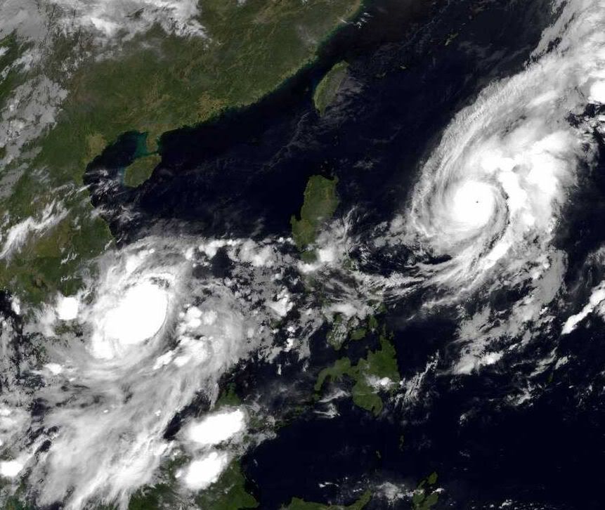
MANILA, May 8 (Reuters) - Fifteen people were killed, including a 10-year-old girl, when a typhoon pounded the northern Philippines, triggering mudslides and tearing roofs off houses before weakening, officials said on Friday. Typhoon Chan-Hom, the fifth to hit the Philippines this year, destroyed roads and bridges and felled power lines in several provinces on the main island, Luzon.
Thirteen villagers were killed in landslides in northern Ifugao province, a mountainous area on Luzon famous for its rice terraces, Ifugao Governor Teodoro Baguilat told Reuters by phone.
Downgraded to a tropical storm, Chan-Hom crossed the northern Philippines early on Friday and is now headed towards China.
Forecast second quarter national rice production was cut by more than 1 percent after Typhoon Kujira hit the central Philippines last weekend, killing 27 people.
Source: Reuters
MANILA, May 8 (Reuters) - Fifteen people were killed, including a 10-year-old girl, when a typhoon pounded the northern Philippines, triggering mudslides and tearing roofs off houses before weakening, officials said on Friday. Typhoon Chan-Hom, the fifth to hit the Philippines this year, destroyed roads and bridges and felled power lines in several provinces on the main island, Luzon.
Thirteen villagers were killed in landslides in northern Ifugao province, a mountainous area on Luzon famous for its rice terraces, Ifugao Governor Teodoro Baguilat told Reuters by phone.
Downgraded to a tropical storm, Chan-Hom crossed the northern Philippines early on Friday and is now headed towards China.
Forecast second quarter national rice production was cut by more than 1 percent after Typhoon Kujira hit the central Philippines last weekend, killing 27 people.
Minstens 30 doden door tyfoon Chan-Hom op Filipijnen
Verschillende noordelijke provincies van de Filipijnen zijn de voorbije dagen getroffen door een krachtige tyfoon. De dodentol is inmiddels opgelopen tot minstens dertig doden. Verder zijn er nog zeven vermisten. Hulpploegen zijn uitgestuurd naar de getroffen gebieden.
Volgens de Nationale Raad voor Rampencoördinatie (NDCC) zijn meer dan 60.000 mensen getroffen door tyfoon Chan-Hom. De meeste dodelijke slachtoffers vielen in de provincies Pangasinan en Ifugao, waar 24 doden zijn geteld.
Ruim 6.300 mensen werden overgebracht naar opvangcentra. De schade aan de infrastructuur en gewassen is aanzienlijk. (belga/jv)
bron:

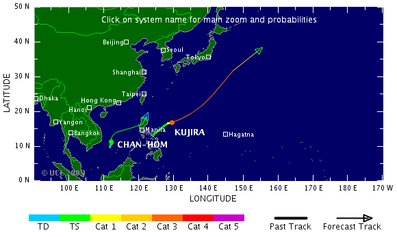
quote:Within a week’s time, the northern Philippines island of Luzon was hit by two tropical cyclones. On May 2 and May 3, 2009, Tropical Storm Kujira inundated parts of southern Luzon in the northeast-central Philippines with torrential rains. On May 7, Typhoon Chan-hom (known locally as "Emong") made landfall on the northwest coast of Luzon, bringing strong winds, heavy rains and yet more flooding to the beleaguered island. The distribution of rain from the two storms is shown in this image.
The image is based on data from the Tropical Rainfall Measuring Mission (TRMM) satellite, which was launched in November 1997 with the objective of measuring rainfall over the Tropics. In addition to making direct rainfall measurements, TRMM data are used to calibrate rainfall estimates from other satellites. This image was made with such TRMM-calibrated data from the near-real time Multi-satellite Precipitation Analysis (TMPA) between May 1 and May 10.
The most extreme rainfall totals, located over southern Luzon, are associated with Tropical Storm Kujira. The storm lingered over the region, dumping 600 millimeters or more (about 24 inches) of rain, shown in dark blue. After pulling away from the island, Kujira developed into a powerful typhoon. The fast-moving Typhoon Chan-hom roared ashore over northern Luzon on May 7, where it dropped about 150 mm (6 inches) of rain (green). The large difference in rainfall between the two storms was due to the difference in their forward motion and not their intensity—Kujira was a slow-moving tropical storm at the time, while Chan-hom was a fast-moving typhoon.
The two storms together left at least 63 people dead, reported the AFP wire service on May 10. Most of the fatalities occurred as a result of landslides and floods. Additional images of the two storms are available on the TRMM web site.
Krijgen we nu al de eerste tropische storm in de Golfregio?
Het 'officiële seizoen' begint pas op 1 juni

NOAA: verwacht een normaal hurricane seizoen
OAA (National Oceanic and atmospheric Administration) verwacht een orkaanseizoen die voldoet aan het klimatologisch gemiddelde.
De laatste jaren was het orkaanseizoen vrij actief met als meest opvallende jaar 2005 toen een groot aantal hurricanes het levenslicht zagen. De meeste bekendheid kreeg
hurricane Katrine die enorme schade aanrichte in New - Orleans. NOAA gaat uit van 14 tropische stormen waarvan een aantal uit zullen groeien tot een hurricane. Voorlopig
gaat men er van uit dat er 1 a 3 mayor hurricanes zullen ontstaan. Dit zijn Orkanen die vallen in de categorie 3 of meer op een schaal van 5. Het seizoen start op 1 juni. Dat het seizoen iets minder actief zal zijn wordt o.a. veroorzaakt door de mogelijk opkomst van een El Nino.
vwk
quote:Aila moves towards coast
The cyclonic storm 'Aila' over north Bay and adjoining west central Bay moved northwards over the same area.
The storm is likely to intensify further and move in a northerly direction and cross West Bengal-Khulna coast by afternoon or evening.
It was centred at 9am on Monday about 435 km southwest of Chittagong port, 405 km southwest of Cox's Bazaar port and 285 km southsouthwest of Mongla port, said a special weather bulletin issued Monday morning said.
Maximum sustained wind speed within 54 km of the storm centre is about 70 kph rising to 90 kph in gusts or squalls. Sea will remain very rough, the bulletin said.
Maritime port of Mongla has been advised to keep hoisted danger signal number seven.
The coastal districts of Bhola, Barisal, Patuakhali, Barguna, Pirozpur, Jhalokathhi, Bagerhat, Khulna, Satkhira, Jessore and their offshore islands and chars will be under danger signal number seven.
Maritime ports of Chittagong and Cox's Bazaar have been advised to keep hoisted danger signal number six.
The coastal districts of Cox's Bazaar, Chittagong, Noakhali, Feni, laxmipur, Comilla, Chandpur and their offshore islands and chars will be under danger signal number six.
Under the influence of the storm, the coastal districts of Khulna, Bagerhat, Borguna, Satkhira, Barisal, Patuakhali, Bhola, pirozpur, Jhalokathhi, Laxmipur, Noakhali, Feni, Chandpur, Chittagong, Cox's Bazaar and their offshore islands and chars are likely to experience heavy to very heavy rain accompanied by squally winds of speed up to 90 kph with the passage of the storm.
The low-lying areas of the coastal districts of Khulna, Bagerhat, Borguna, Satkhira, Barisal, Patuakhali, Bhola, Pirozpur, Jhalokathhi, Laxmipur, Noakhali, Feni, Chandpur, Chittagong, Cox's Bazaar and their offshore islands and chars are likely to be inundated by storm surge of height of six to eight feet above normal astronomical tide.
All fishing boats and trawlers over north Bay have been advised to remain in shelter till further notice.
River traffic halted
The weather has forced suspension of ferry movement since 8am Sunday on all rivers routes, Patuakhali river port official Md Shahidul Mia said.
Fishermen are coming back from the sea because of high tide, said general secretary of fish traders committee Nimai Chandra from Kuakata.
The rivers in the costal areas are flowing in high tide because of the depression in the bay, said Ahsan Azim from Charkajal.
It had been raining sporadically in the coastal areas of Patuakhali since Saturday midnight, our correspondent said.
Barguna wary
The people of the coastal southern district of Barguna, hit by cyclone Sidr in late 2007, are living in constant fear on the news that a depression in the Bay of Bengal has deepened and still intensifying.
Our correspondent says it has been raining sporadically since Saturday midnight and the sun has remained behind the clouds.
Hundreds of fishing trawlers have returned to Pathorghata, Noli and Taltoli from the Bay until Sunday afternoon, said president of Barguna District Trawler Owners' Association Golam Mostafa Chowdhury.
"We will start calling people to shelter buildings through megaphones as soon as the level of the signal is increased," said the team leader of cyclone preparation activities and member of Borguna Red Crescent Unit Zakir Hossain Miraj.
Filmpje RTL: Ravage na Cycloon Aila in Bangladesh en Indiaquote:Aila maakt zeker 28 doden in India en Bangladesh
Na de doortocht van de cycloon Aila zijn in het oosten van India en buurland Bangladesh zeker 28 doden geteld. In de miljoenenmetropool Calcutta (Kolkata) alsook in andere delen van de deelstaat West-Bengalen lieten 19 mensen het leven. In Bangladesh kwamen negen mensen om het leven. Er zijn nog tientallen vermisten.
De cycloon kwam met windsnelheden tot 120 kilometer per uur aan land en zorgde voor aanzienlijke schade. Alleen in India werden zo'n 110.000 mensen uit hun huizen verdreven. Het leven in Calcutta viel maandag stil. De autoriteiten hadden de kustbewoners 's morgens voor de cycloon gewaarschuwd. De tropische storm vormde zich boven de Golf van Bengalen. In Bangladesh ligt de passage van cycloon Sidr in november 2007 nog vers in het geheugen: die eiste toen aan ongeveer 4.000 mensen het leven, tienduizenden personen raakten dakloos. (BEH)
http://www.rtl.nl/compone(...)22/Tue11.cycloon.xml
Cycloon Aila eist ruim 70 levens in India en Bangladesh
Eigen topic gegeven
[ Bericht 37% gewijzigd door Frutsel op 26-05-2009 12:23:05 ]

Tropical Storm Aila struck southern Bangladesh and eastern India on May 27, 2009. The New York Times reported that floods and mudslides killed at least 191 people and left hundreds of thousands more homeless. As of May 27, the death toll was expected to rise.
The Moderate Resolution Imaging Spectroradiometer (MODIS) on NASA’s Terra satellite captured this true-color image of Aila on May 25, 2009, the same day that the storm temporarily strengthened to a Category 1 cyclone. Aila almost completely fills this scene, stretching from the Bay of Bengal deep into India, Bangladesh, and Burma (Myanmar). On May 25, Aila’s wind speeds ranged from 74 kilometers per hour (46 miles per hour or 40 knots) to 120 kilometers per hour (75 miles per hour or 65 knots).
According to the Associated Press, some 2.3 million people were affected by Aila, many of them stranded in flooded villages. Storm surges in Bangladesh flooded agricultural areas with salty water. Home to roughly 25,000 residents, the coastal island Nijhum Dwip was reported to be completely submerged. As of May 27, 2009, many rural villages had not yet been reached by relief workers, and the death toll was expected to rise significantly as search and rescue efforts continued.
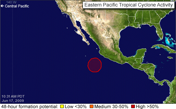
Rustig begin van het seizoen... ik las ergens dat 19 juni het record is dat op zijn laatst op de Oost Pacific zich een storm ontwikkelde. Dat lijken we net niet te gaan halen
In het Atlantische basin verwachten we pas eind juni de eerste ontwikkelingen, aldus lange termijn modellen
In het Atlantische basin verwachten we pas eind juni de eerste ontwikkelingen, aldus lange termijn modellen
Hopelijk een rustig seizoen dit jaarquote:Op woensdag 17 juni 2009 09:12 schreef Frutsel het volgende:
Rustig begin van het seizoen... ik las ergens dat 19 juni het record is dat op zijn laatst op de Oost Pacific zich een storm ontwikkelde. Dat lijken we net niet te gaan halen
[ afbeelding ]
In het Atlantische basin verwachten we pas eind juni de eerste ontwikkelingen, aldus lange termijn modellen

http://www.usatoday.com/w(...)rricane-season_N.htm
quote:Hurricane season off to a typically slow start
The first month of the Atlantic hurricane season ended with a whimper Tuesday: No named tropical storms or hurricanes formed in June.
However, that's not unusual, as the average date of the first named storm doesn't occur until July 10, according to Dennis Feltgen, a meteorologist at the National Hurricane Center in Miami. Feltgen also reports that the average date of the first Atlantic hurricane is Aug. 14.
Since the naming of storms began in 1953, the latest an Atlantic storm has formed was Anita on Aug. 29, 1977. On average, based on records that go back to 1851, a tropical storm forms every other June in the Atlantic basin, which also encompasses the Gulf of Mexico and the Caribbean Sea.
The National Oceanographic and Atmospheric Administration predicted in May that there would be nine to 14 named storms in the Atlantic this year, of which four to seven could become hurricanes, including one to three major hurricanes (Category 3, 4 or 5).
A quiet June doesn't necessarily presage a quiet remainder to the season, reminds Feltgen. In 2004, a year that had 15 named storms — including Charley, Frances, Ivan and Jeanne — the first storm didn't form until July 31.
In the eastern Pacific basin, Hurricane Andres was the only named storm to form in June. It grazed the west coast of Mexico on June 22, killing one person.
No storms or hurricanes are forecast to form in either the Atlantic or Pacific basins for at least the next two days, reports the center.
Het is inderdaad rustig, maar er kunnen nog genoeg orkanen ontstaan in de Atlantische Oceaan.quote:A quiet June doesn't necessarily presage a quiet remainder to the season, reminds Feltgen. In 2004, a year that had 15 named storms — including Charley, Frances, Ivan and Jeanne — the first storm didn't form until July 31.
Het blijft rustig
quote:Tropical Atlantic and Pacific quiet
In the Atlantic basin, a tropical wave that passed through the southern Antilles yesterday may help to enhance some showers and thunderstorms the the western Caribbean Sea today and tomorrow.
Another tropical wave currently crossing the central tropical Atlantic will reach the Antilles by this weekend bringing showers there.
None of these areas are expected to show any tropical organization, and no tropical development is expected over the next few days.
Meanwhile, a flow of tropical moisture over central and southern Florida will bring more downpours today into Friday, but should taper a bit this weekend. The typical afternoon chance of showers and thunderstorms will continue however.
In the eastern Pacific basin, no tropical development is expected in the near term.
Hurricanetrack praat voornamelijk over de Pacific, geeft Atlantisch weinig kansquote:UPDATED: 12:50 pm EDT, July 1, 2009
MAJOR OUTBREAK OF DRY, STABLE AIR IN EAST ATLANTIC AS EAST PACIFIC IS ABOUT TO POP
SAL is back. In this case, the Saharan Air Layer. It is a blast of warm, dusty and very stable air that comes off of Africa and extends out in to the Atlantic. Check out the link below from the CMISS site. It shows very clearly the strong SAL outbreak. You can track its progress over the coming days as the air mass migrates westward. What does it mean for tropical development? A solid cap placed on convection in the east Atlantic- at least for now. While there is a forecast for less than average dust outbreaks over the Atlantic, we can expect to see bursts like the one today. It is fascinating to see and modern satellite technology allows easy tracking of these large scale features.
The Atlantic Basin is and will be very quiet for many days to come. No worries at all for coastal areas for this coming big weekend.
In the east Pacific, all is quiet for now but it appears that several areas of development may pop up in the coming days. The ECMWF model in particular is showing a string of storms developing in about 3 to 10 days. The good news is that it would appear that these potential developments would be far off the coast of Mexico and moving generally away from land. It is amazing to see computer model forecasts for something that is not there now, but very well could be several days out. We'll see. The east Pacific is primed for development right now so it would make sense at least.
Het is een saaie boel de laaste weken als het gaat om tropische stormen. 
mischien stilte voor de storm?
mischien stilte voor de storm?

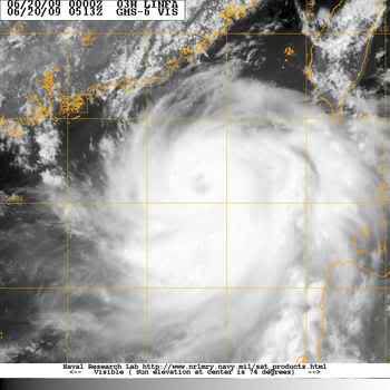
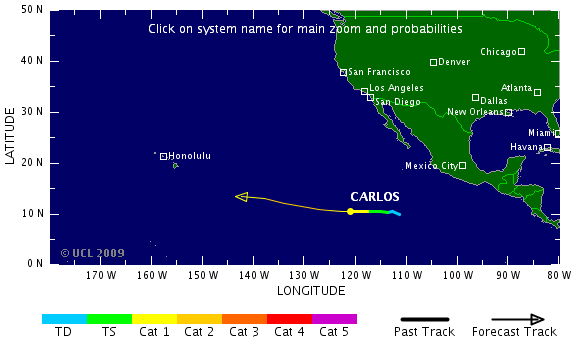
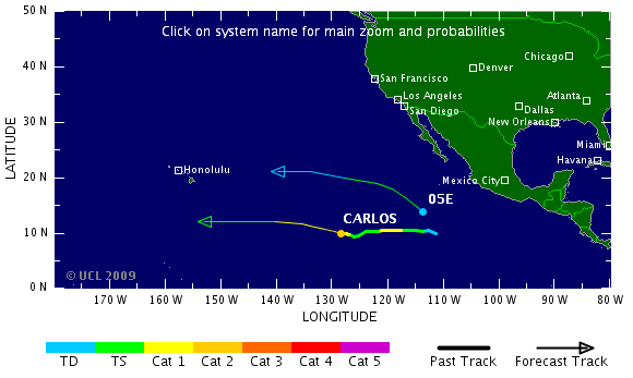
quote:BreakingNews BULLETIN -- TROPICAL STORM CARLOS STRENGTHENS INTO A CATEGORY ONE HURRICANE OFF MEXICO. less than a minute ago
Carlos gaat nog sterker worden ook.
Misschien dat Hawai er nog wat van mee gaat krijgen.
[ Bericht 1% gewijzigd door #ANONIEM op 12-07-2009 21:21:54 ]
Misschien dat Hawai er nog wat van mee gaat krijgen.
[ Bericht 1% gewijzigd door #ANONIEM op 12-07-2009 21:21:54 ]
quote:Carlos stronger; new depression forms
Carlos became the 2nd eastern Pacific hurricane of the 2009 season for roughly a day this past weekend. The tropical cyclone weakened later Sunday into early Monday into a tropical storm.
Early Tuesday morning, an eye feature began to appear and Carlos became a hurricane once again.
Maximum sustained winds are up to 105 miles per hour in a very small area near the center of circulation. Carlos is a tiny hurricane, with tropical storm force winds only extending about 45 miles from the center.
Carlos about 1525 miles west-southwest of Cabo San Lucas, Mexico remains only a threat to marine interests and is expected to remain that way over the next 5 days.
The hurricane is moving to the west near 6 miles per hour, and a general west or west-northwest motion is expected to continue. This westbound track may bring Carlos in shearing winds in a few days that could quickly weaken the tropical cyclone.
A much larger circulation closer to the Mexican West Coast (but far enough away not to be a threat to land) has become Tropical Depression 5-E as of Tuesday evening.
The depression is located about 680 miles south-southwest of Cabo San Lucas, Mexico, with maximum sustained winds near 35 miles per hour. The depression could become a tropical storm sometime on Wednesday. If it does so, it would be called Dolores.
The depression is moving west-northwest around 10 miles per hour, with a general west-northwest motion expected over the next few days.
The Atlantic Basin remains quiet.
wie weetquote:UPDATED: 10:15 am EDT, July 17, 2009
TROPICAL WAVES IN ATLANTIC GETTING A LITTLE MORE ACTIVE
We are about a month away from the real meat of the hurricane season getting started. Signs of that are starting to appear as we see the tropical waves in the eastern Atlantic beginning to get a little stronger. One such wave is being "outlooked" by the NHC as having a low chance of development. It has by far the most impressive look to it of the season but has a long way to go before it would develop fully. Conditions are still quite hostile across much of the deep tropics and the Caribbean Sea. None the less, we'll obviously monitor it as it tracks steadily westward over the next week to 10 days. It won't go away, the energy will remain even if it does not develop right away. Where that energy ends up is important. The farther west these things make it before blossoming, then the closer they are to land areas.
quote:Two Atlantic waves
The tropics are quiet around the globe once again now that what's left of Molave is raining itself out over southern China and northern Vietnam.
In the eastern Caribbean, the tropical wave that brought heavy storms to the islands has been sheared apart. The showers have diminished and the tropical wave is now barely discernible in the wind flow.
The second wave, 700 miles east of the Windward Islands, remains disorganized as it heads westward. It will bring more rain to parts of the Lesser Antilles early week.
quote:Typhoon Molave weakens to tropical depression, bringing heavy rain to south China
GUANGZHOU, July 19 (Xinhua) -- Typhoon Molave weakened into a tropical depression Sunday afternoon after it landed in south China's Guangdong Province early Sunday and then entered neighboring Guangxi.
The storm made landfall in Nan'ao Town in Shenzhen City at 12:50 a.m. with winds of up to 145 km per hour at its center.
From 8 a.m. to 2 p.m. Sunday, downpours drenched Zhanjiang, Maoming, Jiangmen and Yangjiang in Guangdong, with 13 hydrological stations reporting precipitation of more than 100 mm, the Guangdong Hydrological Bureau said.
As of 5 p.m., no casualties were reported in Guangdong.
Maritime rescuers successfully pulled a stranded vessel off Shantou, Guangdong, to Haimen Port of Shantou amid high winds and saved seven crew members on it at 9:30 a.m. Sunday.
The storm left Guangdong and entered Guangxi Zhuang Autonomous Region at 1:40 p.m. and downgraded into a tropical depression at 3p.m. in Wuzhou City.
The National Meteorological Center forecast Sunday afternoon rainstorms would sweep parts of Guangdong, Guangxi, Yunnan and Guizhou Sunday night to Monday.

Vooralsnog niets dusquote:Even though we are seeing a more active pattern with the emergence of stronger tropical waves in the Atlantic, thee is still no reason to be concerned that any of them will develop. The main reason is hostile upper level winds. While we are seeing a flare up of convection with the tropical wave about to move through the Windward Islands, and this will certainly bring its share of squally weather to the region, upper level winds will not allow for much more organization. This is fairly typical of this time of the year as we are still several weeks away from the start to the rapid ramp up in expected activity.
Another area to at least monitor over the coming days is a large and complex weather pattern well off the Southeast coast. It is a combination of mid to upper level energy interacting with a tropical wave and its heat and energy. All of this spells plenty of convection over the southwest Atlantic but nothing seems to be consolidating in to a surface low pressure. If you're heading to the Bahamas, depending on where you are, there is a chance of off and on showers and thunderstorms as this mess of weather persists over the week ahead. It should all lift out by the weekend.
Eerste 'naam-storm' wordt straks pas augustus ofzo

quote:Though Typhoon Molave was still a tropical storm when it moved across the northern tip of Luzon, the largest of the Philippine Islands, on July 17 and July 18, 2009, its drenching rains caused widespread flooding. By July 20, the clouds had cleared enough to give the Moderate Resolution Imaging Spectroradiometer (MODIS) on NASA’s Terra satellite this view of the flooded island. The lower image, from July 15, 2009, shows the Cagayan River system in northern Luzon before the storm came ashore.
Both images contain a mixture of infrared light and visible light to increase the contrast between water and land. In this type of image, water is black. Sediment-laden water tends to be dark blue. The lush, plant-covered land of the tropical island is bright green, while clouds are pale blue and white.
In the wake of the storm, dark pools of water mark the land along the length of the Cagayan River and its tributaries. The flooding is most pronounced near the shore. Another sign of flooding is the plume of sediment that flows from the mouth of the Cagayan River. Floods sweep soil off the land and carry it into rivers and the ocean. The river plume contains more sediment than it had on July 15.
According to the AFP news service, Typhoon Molave caused at least three deaths in the Philippines. Much of the damage came from widespread flooding throughout Luzon. About 95,000 people were evacuated from their homes outside Manila in southern Luzon as a result of flooding, reported the AFP news.


quote:On July 17, 2009, when NASA’s QuikSCAT satellite captured the data used to make this image, Tropical Storm Molave hung over the northern Philippines, drenching the islands with heavy rain and causing widespread flooding. The image shows the structure of winds within the strengthening storm. Purple and red depict the highest wind speeds, while blues and greens point to calmer winds. Barbs indicate the direction of the wind, and white barbs indicate areas of heavy rain. The calm eye of the storm is a circle of blue surrounded by yellow and red. The strongest winds are close to the center on the east side of the storm.
QuikSCAT measures wind speeds over the ocean by sending pulses of microwave energy through the atmosphere to the ocean and measuring the energy that bounces back from the wind-roughened surface. The energy of the microwave pulses changes depending on wind speed and direction, giving scientists a way to monitor wind around the world. About the time that QuikSCAT acquired this image of Tropical Storm Molave over the Philippines, the Joint Typhoon Warning Center estimated the storm’s maximum sustained winds to be about 110 kilometers per hour (70 miles per hour or 60 knots).
quote:A new tropical disturbance has formed north of the central Bahama Islands, about 600 miles east of Miami. The thunderstorm activity is not yet very intense, but does cover a moderately large area. This morning's QuikSCAT pass showed winds of 20 - 25 mph, and no evidence of a circulation trying to form. This region is under about 20 - 25 knots of wind shear, and has the potential for some slow development over the next few days as it moves slowly northwards. The GFS and ECMWF models hint at the possibility that this system may attempt to organize into a tropical depression by Friday, off the coast of North Carolina.
quote:UPDATED: 8:30 am EDT, July 22, 2009
COMPUTER MODELS POINTING TOWARDS LOW PRESSURE AREA DEVELOPING OFF SOUTHEAST COAST SOON
As I mentioned in yesterday's evening post, I am increasingly confident that we will see a low pressure area form somewhere off the Southeast coast- probably later tomorrow. It is originating from what has been a somewhat complex weather pattern over the SW Atlantic. Arriving on the scene shortly is a tropical wave that will add energy to the system. Several of the global computer models indicate that a surface low will form and strengthen as it moves roughly parallel to the East Coast. It appears that it will be far enough off shore to keep the weather from being too adversely affected but boating interests should be aware of this developing situation. The NHC is showing a low chance of development as of now but I believe this will go up later today. If the low is tropical in nature, with a warm core and defined banding features, it could very well get a name- our first of the season. We'll have watch as this system evolves but it does not look to be a significant threat to land- more just an interesting feature to track. I'll post an update later this afternoon.
Die in de Golfregio/Caraiben wordt dus niets. Misschien dan voor de oostkust?
quote:NON-TROPICAL STORM LASHING NEW ENGLAND TONIGHT
Thought I would post a quick update on the non-tropical storm that is affecting a good deal of New England tonight. Checking the latest wind readings- I see wind gusting to 31mph in Montauk with an air pressure reading of 1009 mb. Elsewhere, in Bridgeport, CT, heavy rain is falling with winds steady at 20-25 mph out of the northeast. This is all due to a potent storm that has some of its energy derived from the tropical wave that emerged from Africa many days ago. This wave became quite active in the central Atlantic and looked like it might develop enough to become a tropical cyclone. It did not quite make it but the resulting ocean storm is packing quite a punch for late July! I was in this very region last September tracking hurricane Kyle and believe me, this will be quite a different story than Kyle- or any event of this nature in many years. The storm should pass quickly in to Canada tomorrow but not before dumping very heavy rains and bringing gusty winds and coastal flooding to the remainder of New England
Nog steeds rustig in de Atlantische Oceaan
quote:The Atlantic basin remains quiet.
Three tropical waves are spaced out from the western Caribbean to the far eastern Atlantic. Little, if any, shower and thunderstorm activity is associated with these features and development is not expected.
The middle tropical wave is approaching the Windward Islands. Some showers and clouds are possible over these islands.
At this time, it appears the Atlantic Basin will not see its first named storm before August 1st. This is not too uncommon, as about 25% of the time the first named storm does not occur until August. The last time this happened was 2004 when Alex was named on the first day in August.
No tropical cyclone development is expected in the eastern Pacific. The two features being monitored yesterday remain disorganized.
quote:As far as the tropics go- we will end July without any issues what so ever. All is quiet and should remain that way for another week to perhaps 10 days. After the first week of August, I see a pattern change in the upper level wind flow that could allow for organized deep convection to begin flaring up in the Atlantic Basin. The tropical waves over Africa are strong and robust but the atmosphere over the eastern Atlantic has not been favorable to allow them to develop. There are signs in the longer range modeling that suggest this will change for a time beginning close to mid-August. For now, no problems exist in either the Atlantic or the east Pacific- so far so good.
quote:TROPICAL STORMS AND HURRICANES LIKELY TO BE SCARCE FOR A WHILE
From the looks of things, we will not see any tropical storms or hurricanes anytime soon. The pattern is still simply not conducive for any significant development. We are seeing quite a robust line of tropical waves emerge from the coast of Africa but hostile upper level winds and other factors are keeping them in check and not allowing them to grow and develop. I see nothing in the long range computer models to suggest a change anytime soon. After about August 10 or so, there may be a period of more favorable conditions but this remains to be seen
Hmmm er was toch een lage zeewatertemperatuur in de Atlantische oceaan ter hoogte van de evenaar toch?
Lage zeewatertemperatuur = minder kans op orkanen?
Lage zeewatertemperatuur = minder kans op orkanen?
Drugs are good mkay?
Meerdere oorzaken hebben d'r invoed op... maar dat is er idd één 
Maar je moet dan naar het water kijken vanaf de westkust van Afrika naar de Golf van Mexico, want daar zullen ze ontstaan. Daar is ook de wind van belang, bijv op de straalstroom enzo
Maar je moet dan naar het water kijken vanaf de westkust van Afrika naar de Golf van Mexico, want daar zullen ze ontstaan. Daar is ook de wind van belang, bijv op de straalstroom enzo
Iddquote:
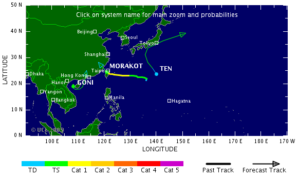
Morakot
Deze gaat nog flink wat ellende brengen in China.
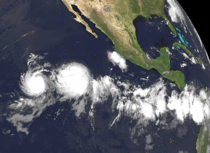
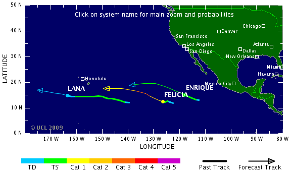
Tropical Strom Felicia is inmiddels ook ontstaan, naast Enrique aan de Pacifische oostkust
Maar niet lang meer:quote:Op dinsdag 4 augustus 2009 17:03 schreef Frutsel het volgende:
[..]
Idd


Eastern Pacific storms, monitoring Atlantic
There are two active systems in the eastern Pacific which are no threat to land.
Tropical storm Enrique with top sustained winds of 60 mph is located just over 730 miles southwest of Cabo San Lucas, Mexico. Enrique is forecast to strengthen some, but stay just below hurricane status as it moves to the west-northwest in the open Pacific.
Just to the west of Enrique, is Tropical Storm Felicia. Felicia is forecast to strengthen gradually and should become a hurricane over the next couple of days. The system is located around 1200 miles southwest of Cabo San Lucas, Mexico and is no threat to land.
The Atlantic Basin remains quiet overall. However there is one area of interest well out in the eastern Atlantic.
An area of low pressure is located well southwest of the Cape Verde Islands between 30 and 40 west longitude. There continues to be some persistent convection and it will be monitored for slow development while moving off to the west.
So far we've had one tropical depression in May this season and no named storms.
In the Western Pacific, weak Tropical Storm Goni (50 mile per hour sustained winds) is forecast to move into the Mainland China Coast later today (Eastern time). Locally heavy rain appears to be the biggest threat from this cyclone.
Another tropical storm is located well east of Taiwan, named Morakot (50 mile per hour sustained winds). Although the track of this system is uncertain, it is expected to become a minimal typhoon on Wednesday (Eastern time) and head towards mainland China's Coast late in the week or over the weekend.
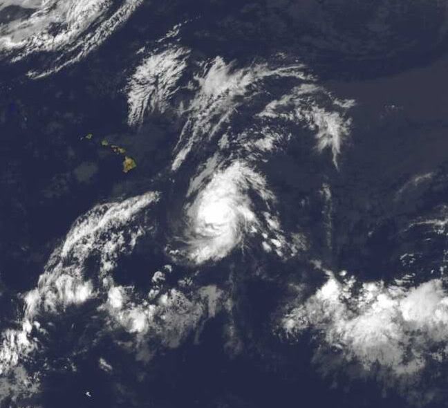
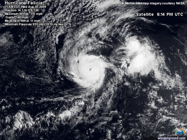
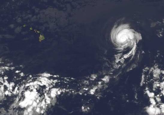
Felicia is inmiddels een caegorie 1 geworden (en wordt nog sterker) en gaat volgens de voorspelling richting Hawai.
Felicia is de krachtigste storm van dit seizoen tot nu toe, volgens mij.
Althans, aan de US West/Eastcoast dan
Het Atlantische Basin komt ook in beweging...quote:DEEP TROPICAL CONVECTION ON THE INCREASE AS PATTERN READIES FOR DEVELOPMENT
Things are changing. The east Pacific is getting quite active and the reasons for it are coming east with time. Right now we have TS Enrique and TD 8-E in the waters well off the coast of Mexico- neither system poses an immediate threat to land. What it appears to indicate however, is that a more favorable pattern is migrating west to east and should be in the Atlantic Basin within the next few days. We are already seeing a very impressive tropical wave far out in the east Atlantic that has the NHC calling for a low chance of development. Some of the computer models pop in and out with latching on to this feature as it moves steadily west. Water temps are certainly warm enough but upper level conditions and even the moisture content of the atmosphere may limit development for a while longer. None the less, as we progress through the next week to 10 days, I expect that we will see a gradual increase in the chances of getting a named storm somewhere in the Atlantic Basin.
Met cat5 over Hawai heen straksquote:Op woensdag 5 augustus 2009 12:52 schreef Frutsel het volgende:
Felicia is de krachtigste storm van dit seizoen tot nu toe, volgens mij.
[..]
Die 2 gaan gewoon samen straks en vormen samen 1 mega orkaan die over hawai trektquote:Op woensdag 5 augustus 2009 20:33 schreef aloa het volgende:
Felicia is al een cat 3 met een duidelijk oog.
[ afbeelding ]
Hmm..begin van de week leek Morakot gewoon een TS te worden, maar nu zelfs een Cat.3 Hurricane. Taiwan krijgt de volle laag

Morakotquote:NASA's Aqua satellite captured an infrared image that showed a huge cyclone named Morakot tracking through the East China Sea, on the way to a landfall in mainland China. Morakot is a large storm with maximum sustained winds near 69 mph (60 knots), just 5 mph shy of a category one hurricane strength. It's currently located in the East China Sea, near 23.2 north and 130.4 east. That's about 300 miles southeast of Okinawa, Japan. Its moving west near 14 mph. The Atmospheric Infrared Sounder is an instrument used in tropical storm research that flies on Aqua. AIRS provides visible, infrared and microwave images of tropical storms. AIRS also measures cloud top temperature and pressure and the profile of water vapor as functions of height. Infrared imagery shows the temperature of the cloud tops which gives a hint about the power of the thunderstorms in a tropical cyclone. The colder the clouds are, the higher they are, and the more powerful the thunderstorms are that make up the cyclone. Morakot will keep moving westward, and it will remain in warm sea surface temperatures and low wind shear over the next 72 hours, which will enable it to maintain its strength. Morakot's forecast track takes the center north of Taiwan and predicts a landfall almost directly between Hong Kong and Shanghai on August 6.

Hmzquote:
[ afbeelding ]
Hmm..begin van de week leek Morakot gewoon een TS te worden, maar nu zelfs een Cat.3 Hurricane. Taiwan krijgt de volle laag
[ afbeelding ]
[..]
Morakot
[ afbeelding ]
Ziet er naar uit dat dat de eerste wordt iddquote:A VERY ACTIVE PATTERN APPEARS LIKELY AS WE GET DEEPER IN TO AUGUST
Even though it has been a very quiet hurricane season for the Atlantic, things are about to change and in a hurry. First up however, is TS Felicia in the Pacific. The good news, and it really is considering how strong Felicia was recently, is that the storm is on its way down in terms of overall impacts to Hawaii. The latest forecast track from the CPHC shows Felicia passing to the north of the Big Island with the storm quickly fading while it does so. Effects should be quite minimal with the exception of increased seas along the north facing beaches. Not sure if they are filming LOST out there now or not (huge fan here), but it could make for some incredible sunsets coming up. Other than that, Hawaii will not sustain any serious negative impacts from Felicia.
In the Atlantic, the pattern change to a more favorable environment seems to be well on its way. We have what looks to be a developing depression way out near the Cape Verde Islands and even more energy lining up over Africa. These next two weeks or so could very well be the most active part of the hurricane season if forecasts for a hostile peak in September hold true. The long range computer models are latching on and developing multiple systems over the next several days. This is all very much expected and is by no means a surpise- even in the face of such a slow start to the season. There is absolutely nothing to be alarmed about right now. The season is coming to life and people all along the coastal areas of the U.S. and adjacent land masses should simply pay attention and be ready to act if one of these potential developments poses a problem down the road. It's all about being aware. We are very busy these days and life moves fast. The tropics can change just as fast but still give us plenty of warning. So far, we are looking really good this season- the hope is that it continues. But hope alone will not prepare people for what may lie ahead.
bronquote:Tientallen doden door tyfoons in Oost-Azië
In het Verre Oosten zijn zeker 42 mensen omgekomen toen de regio werd getroffen door tyfoons. Dat meldden de autoriteiten in de verschillende landen maandag. Tientallen mensen worden nog vermist.
De meeste doden vielen op Taiwan. Daar verloren door tyfoon Morakot zeker 23 mensen het leven, terwijl nog 56 mensen worden vermist. In het weekeinde viel op het eiland een recordhoeveelheid regen (250 centimeter).
Het weg- en treinverkeer ondervinden grote hinder van overstromingen en aardverschuivingen. Op veel plaatsen is de elektriciteit uitgevallen.
Tropische storm
In China is Morakot afgezwakt tot een tropische storm. Er kwamen hier minstens zes mensen om. De autoriteiten hadden in de kustprovincies uit voorzorg meer dan een miljoen mensen geëvacueerd.
In Japan zijn zeker dertien mensen omgekomen door overstromingen en aardverschuivingen, die zijn veroorzaakt door de nadering van de tyfoon Etau. Achttien mensen worden vermist. De hevige wervelstorm zal vermoedelijk dinsdag op volle kracht over Japan trekken. Er zijn 50.000 mensen geëvacueerd.
quote:UPDATED: 8:10 pm EDT, August 10, 2009
I do not have much in the way of new information tonight since nothing dramatic has really taken place since this morning. In the Pacific, Felicia is still winding down and should pass through Hawaii without much fanfare. In fact, the storm is basically just a swirl of low clouds with sparse convection at best.
In the Atlantic, we'll be watching 99L way out near the Cape Verde Islands for slow development. It could take a while and of course, there is no guarantee it will ever really get cranking. However, its energy will remain in tact even though it may not become a tropical cylcone right away. We must always watch these kinds of features as the progresses steadily westward. Elsewhere, tropical waves at around 47 west and 62 west also bear close monitoring as they too try and organize slowly. The pattern is becoming more and more favorable for us to see perhaps several named storms over the coming two to three weeks. Nothing out there just yet but it's getting close.

wat ben je dan laat met je tvpquote:
TVP.... Blijft een boeiende topicreeks dit
Hoewel er nu wel 4 systemen in wording zijn, ben benieuwd of daar ook een orkaan uitkomt. Maar tot nog toe hebben ze het gelukkig rustig.
Eastern Pacific heeft aardig wat voor de kiezen gehad hoor, alleen niet aan land 
BTW: Heel 'DE' als subforum blijft boeiendquote:
TVP.... Blijft een boeiende topicreeks dit
Hmm... hij maakt zich duidelijk zorgen over het systeem dat zich nu nog aan het ontwikkelen is dus. En dat elke 'run' die hij uitvoert er uit ziet dat er een flinke orkaan kan ontstaan en dat vooral mensen in de "Lesser Antilles" de komende tien tot veertien dagen hun ogen open moeten houden.quote:UPDATED: 9:15 am EDT, August 12, 2009
TROPICS GOING TO BE BIG NEWS OVER THE NEXT WEEK TO 10 DAYS
It is time to pay closer attention to the Atlantic Basin and its growing areas of concern. I say concern because it is time to take notice of what is going on out there and be prepared for it. I am not talking about just the United States either- remember, we have quite a few land masses out there in the Basin. Here's what we have...
TD2 should become a tropical storm later today if it is not one already. It is not of much concern right now and should avoid the Lesser Antilles as it moves west over the next five days. Beyond that time period, we will just have to see if it survives a trip through some stronger upper level winds before worrying where it ends up. There's plenty of time to monitor its progress and thus far, it looks to remain fairly weak.
The other developing story will be a new tropical cyclone taking shape right now off the coast of Africa. The GFS computer model in particular has been remarkably consistent with its forecast of a long-track system in the Atlantic. The tropical wave that would be "the one" is now off the coast of western Africa and is already looking better organized as each hour passes. It should become a tropical depression within the next two days and rapidly strengthen beyond that. My first concern is for the Lesser Antilles. From the looks of the steering patterns, an almost due-west track seems likely for this system once it gets going. This would put it in the vicinity of the Windwards and Leewards in about a week- maybe less. I figured people would want as much notice as possible just in case the computer modeling is even close to spot on. Run after run after run of the GFS shows this system plowing through the eastern Caribbean. Perhaps the model will be wrong, but it did a similar job of accurately forecasting the genesis and track of powerful hurricane Dean in 2007. So if you live in or are planning a trip to the Lesser Antilles and surrounding region, pay close attention to the tropics from now on. We have the luxury of seeing the possible future with computer guidance and related technology, there should be no suprises in this day and age.
Lastly, a tropical wave crossing the Antilles now should continue generally WNW and in to the Gulf of Mexico early next week. We'll see if it blossoms and develops more. This is where model guidance is tough because some show development, others do not. It is a feature to watch until it interacts with land and dies away. Its passage through the Caribbean will bring sporadic showers and thunderstorms but otherwise not much more than that.

Ben benieuwd wat er met dat ding op de atlantische oceaan gaat gebeuren. En voor de kust van West-Afrika nog een mooi frontje.
's Avonds een man, overdags rustig an
Lesser Antilles.. Ik zit op Curacao dus ik ga zeker mijn ogen open houden.
Ik zit bij de landmacht en ze gingen er vanuit dat er geen orkaan zou komen, maar mocht er eentje komen dan moeten wij hulp gaan bieden..
Mogen ze ons snel even alvast gaan voorbereiden voor de zekerheid..
Ik zit bij de landmacht en ze gingen er vanuit dat er geen orkaan zou komen, maar mocht er eentje komen dan moeten wij hulp gaan bieden..
Mogen ze ons snel even alvast gaan voorbereiden voor de zekerheid..
Volgende week woensdag zit die bij domicaanse republiek/cuba als het zo doorgaat....laat ik nou net volgende week woensdag een tussenlanding hebben op cuba, hahaquote:
Drugs are good mkay?
Denk dat TD 2 niet zover komt... d'r komt er nog eentje achteraan die eind volgende week problemen kan gaan geven.quote:
[..]
Volgende week woensdag zit die bij domicaanse republiek/cuba als het zo doorgaat....laat ik nou net volgende week woensdag een tussenlanding hebben op cuba, haha
Nja hij kan aan kracht winnenquote:Op donderdag 13 augustus 2009 14:27 schreef Frutsel het volgende:
[..]
Denk dat TD 2 niet zover komt... d'r komt er nog eentje achteraan die eind volgende week problemen kan gaan geven.
Drugs are good mkay?
Inmiddels heeft het NHC Tropical Despression 2 gedeclasseerd en is dus van de kaart verdwenen als 'Tropisch' ... Helaasch dus... maar zoals ik zei.. het gebied daar achter, dat wordt interessant om te volgen, dat wordt de eerste 'naam-storm' van het seizoenquote:
Boven hispaniola ligt ook nog een lekker gebied wat een kleine kans heeft om uit te groeien tot meer. Dan helpt die temperatuur in elk geval welquote:
De golf van Mexico is al aardig opgewarmd naar een dikke 30-32 graden
Guillermo is inmiddels een orkaan
Een drie zelfsquote:
En de tweede is er nu ook
[ afbeelding ]
Er komt er misschien dus nog één achteraanquote:ANA, BILL AND 91L ALL KEEPING US PLENTY BUSY
There is quite a lot going on tonight as the tropics have sprung to life in grand fashion. We have TS Ana, TS Bill and now 91L in the eastern Gulf of Mexico- plus a new tropical wave off of Africa that could develop over the next few days.
First, let's discuss the system in the Gulf. It is in association with a tropical wave that we have tracked for the last week or so. It is now trying to flare up in a small area just to the west of Florida. Tampa radar can clearly see a counter-clockwise spin to the feature out over the open Gulf. Hopefully it will move inland later tomorrow or Monday before much more organization can take place. But, let's remember Humberto two years ago off the Texas coast. It was small and was able to ramp up very quickly. Do not be suprised to see this do something similar- perhaps not that dramatic but there is a chance that this becomes a tropical depression or even a tropical storm before reaching the coast along the Florida Panhandle or nearby. We'll watch it closely and people visiting/living in the area need to be ready for a quick change to the weather as this system comes rolling in. It will have squally weather with gusty winds and rough seas. It will be interesting to see what the NHC says about it tomorrow morning.
Meanwhile, Ana is struggling to keep its existence going against dry air and a fairly quick forward pace. Odds favor this one falling short of its potential which is great news for areas to its west. This is not say that nothing will happen but the intensity forecast is looking better with each update. Still, people in the northern Leewards through Puerto Rico and Hispaniola should pay close attention to the future progress of Ana. Remember- rain fall can be deadly if too much falls too soon or over terrain that cannot handle it.
Bill continues to demonstrate to us that it will become a powerful hurricane over the next few days. It is large and steadily getting better organized over the deep tropical Atlantic. The latest forecast suggests more good news for the islands of the NE Caribbean as Bill should pass by to the north and east. The models are trending towards a more northwesterly course towards the five day time period. How much so and then what happens after that remains to be seen. Obviously, we will keep up with the latest model runs to see what guidance they can provide.
Farther east and off the west coast of Africa we are monitoring another tropical wave with potential for development as it too moves west. Things will be quite busy over the next several days with a lot of information coming out of many sources.
Hmm ik ga woensdag landen op Cuba en dan is tropische storm ANA daar precies, weet iemand hoe dat zit met landen als er zulk slecht weer is?
Het is een tussenstop naar mexico
Het is een tussenstop naar mexico
Drugs are good mkay?
Bill kan wel eens een hele grote hurricane gaan worden.. Cat. 3 of 4 is niet uit te sluiten. Zelfs 5 is mogelijk, maar dat is maar 2%.
's Avonds een man, overdags rustig an
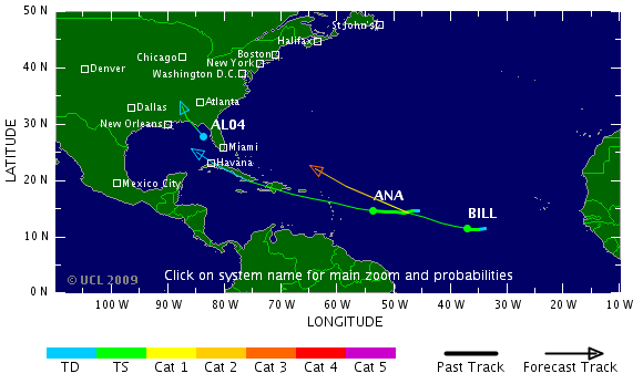
Ana duikt de Golf van Mexico ook nog in. Het water is daar meer dan 30 graden. Ik ben benieuwd of ie daar nog gaat aansterken.
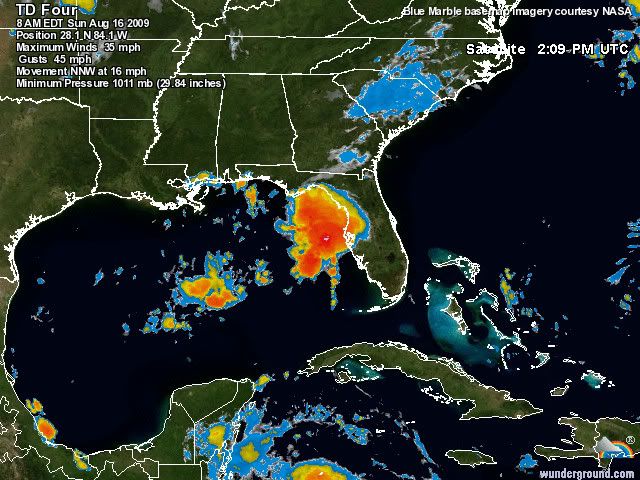
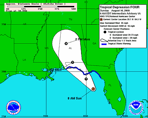
quote:Tropical Depression 4 (35 mile per hour winds) developed from an area of low pressure off of Florida's West Coast early this morning. As of 8 a.m. Sunday morning, T.D. 4 was located about 125 miles south-southeast of Apalachicola, Florida. It is forecast to become a tropical storm later today (at which time it would become Tropical Storm Claudette), and make landfall late this afternoon or this evening.
Tropical storm warnings extend from the Alabama/Florida border eastward to the Suwannee River, Florida. This means that tropical storm conditions are expected somewhere in this area within the next 24 hours.
Heavy rain, locally 3 to 5 inches or more, is possible over the Florida Panhandle over the next 24 to 36 hours, with heavy rain spreading inland across portions of the Southeastern U.S. over the next couple of days.
Bill wordt een monster. Ana gaat hopelijk kracht winnen in de Golf van Mexico. Spektakel gegarandeerd.
Nu al veel overlast in V.S. door Claudette. Heel veel regen.
Nu al veel overlast in V.S. door Claudette. Heel veel regen.
's Avonds een man, overdags rustig an

Leuk plaatje idd, kunnen we wel gebruiken, maar is het geen fictie/photoshop?
Om welke orkanen zou het hier gaan en wanneer dan? Of is dit een plaatje van 3 orkaantjes Andrew in één?
Om welke orkanen zou het hier gaan en wanneer dan? Of is dit een plaatje van 3 orkaantjes Andrew in één?
Dat laatste; zie ook de titel van die afbeelding.quote:
Leuk plaatje idd, kunnen we wel gebruiken, maar is het geen fictie/photoshop?
Om welke orkanen zou het hier gaan en wanneer dan? Of is dit een plaatje van 3 orkaantjes Andrew in één?
Om vervolgens door te reizen via het kanaal op naar NL om daat een leuk stormpje en water te gevenquote:Op maandag 17 augustus 2009 17:07 schreef Burnie88 het volgende:
Wel jammer dat Bill afbuigt naar het noordwesten...
Haha, ja windkracht 7 en een zondagmiddag regen. Ik wil dat ding in de mexicaanse golf zien gaan en uit zien groeien tot een snoeiharde cat. 5quote:Op maandag 17 augustus 2009 18:37 schreef Co_OL het volgende:
[..]
Om vervolgens door te reizen via het kanaal op naar NL om daat een leuk stormpje en water te geven
Maar het seizoen is wel echt begonnen nu. Ik hoorde dat er al weer een 4e stormfront zat aan te komen?
's Avonds een man, overdags rustig an
jij hebt liever dood en verderf in de Dominicaanse Republiek, Haiti en vervolgens Florida?quote:
Wel jammer dat Bill afbuigt naar het noordwesten...
Vind ik wel spectaculair ja. En ik ben niet de enige op dit topic die er zo over denkt denk ik.. Hoe extremer de storm, hoe mooier om te volgen. Is ook met tornado-outbreaks enz. het geval.quote:Op maandag 17 augustus 2009 19:53 schreef Frutsel het volgende:
[..]
jij hebt liever dood en verderf in de Dominicaanse Republiek, Haiti en vervolgens Florida?
Maar uiteraard zijn slachtoffers nooit 'gaaf' of 'mooi'.
[ Bericht 7% gewijzigd door Burnie88 op 17-08-2009 22:45:14 ]
's Avonds een man, overdags rustig an

Is er eigenlijk ooit in de geschiedenis een orkaan in Nederland voorgekomen? Als dat überhaupt mogelijk is  .
.
quote:Op maandag 17 augustus 2009 22:35 schreef 0100 het volgende:
Is er eigenlijk ooit in de geschiedenis een orkaan in Nederland voorgekomen? Als dat überhaupt mogelijk is
knmiquote:Orkaankracht 12 wordt in ons land zelden bereikt en als het gebeurt dan heeft de wind meestal maar korte tijd die enorme kracht. De laatste keer dat op een enkele plaats aan onze kust eventjes windkracht 12 is gemeten was 16 december 1979. Ook in de nacht van 2 op 3 januari 1976 werd in IJmuiden windkracht 12 gemeten, maar toen is op verscheidene andere plaatsen enkele uren achtereen een gemiddelde windsnelheid van 115 km/u gemeten, net iets onder orkaankracht. Op 7 september 1944 registreerde Vlissingen gemiddeld over een uur een windsnelheid van 122 km/u. Voor zover bekend is dat de enige storm geweest ooit, waarin de windmeter geruime tijd op windkracht 12 stond.
Mooie site
www.stormpulse.com
Leuk ook dat als je het tabje clouds aanzet je precies alle wolken ziet opgelijnd vanaf Egypte tot Florida
www.stormpulse.com
Leuk ook dat als je het tabje clouds aanzet je precies alle wolken ziet opgelijnd vanaf Egypte tot Florida
Im a bad man....but i forgive myself
Luck is for losers
Luck is for losers
Hmm... worst-case-nightmare is toch wel dat zo'n storm de noordoost kust van de VS zou raken, dan loopt heel manhatten onderquote:UPDATED: 10:55 pm EDT, August 17, 2009
NO MAJOR CHANGES FOR CATEGORY TWO HURRICANE BILL
This will be kind of short since there are no earth-shattering changes in the forecast for Bill. Top winds are now 100 mph and are expected to easily go higher and make Bill a solid category three hurricane. It is interesting too that the NHC mentions the fact that computer models suggest that Bill will grow in size as well- covering more ocean. That should be amazing to see- hopefully not at the expense of it hitting land somewhere.
So what about that? Where is Bill headed? The NHC continues to project a track more to the north over time as a break in the large ridge of high pressure over the Atlantic allows Bill to slip in- like water finding its way in to a crack in a large rock. From there, it is possible that Bill could turn east of north and never affect land or it could turn too late and clip Bermuda, the East Coast of the U.S. and/or the Canadian Maritimes. None of the models are really reliable enough to project that far in to the future to determine where Bill will end up. I will say this, if it makes it past 70 west longitude, then it would have to turn east of north to miss the East Coast of the U.S.- right now, the 5 day plot is 68.5 or 1.5 degrees east of that essential spot (in my mind). So as you can see, every degree west that this thing tracks is critical down the road. Folks in Bermuda, the U.S. East Coast and particularly the Canadian Maritimes should stay on top of this. I am sure you would even without me saying so- but this is an August hurricane with potential to deal quite a punch should it hit land.
Leuke site iddquote:
Mooie site
www.stormpulse.com
Leuk ook dat als je het tabje clouds aanzet je precies alle wolken ziet opgelijnd vanaf Egypte tot Florida
Heb hem ff in de OP als linkje toegevoegd, thx!
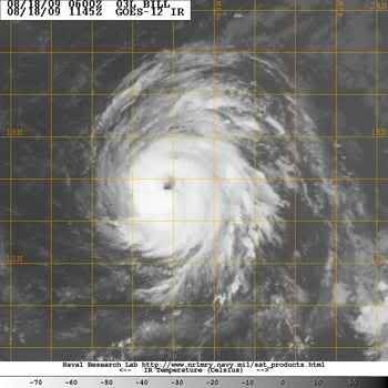
Kan best wel ja. De koers van de modellen wordt ook steeds naar het westen bijgesteld.quote:Op dinsdag 18 augustus 2009 11:57 schreef Frutsel het volgende:
[..]
Hmm... worst-case-nightmare is toch wel dat zo'n storm de noordoost kust van de VS zou raken, dan loopt heel manhatten onder
Hij koerst nu zo'n beetje richting New Foundland.
Ana (restanten) laat veel regen achter op Cuba. Ik ben benieuwd of die weer tot tropische storm terugkeerd, als ze in de Golf van Mexico komt.
[ Bericht 4% gewijzigd door #ANONIEM op 18-08-2009 19:47:13 ]
[ Bericht 4% gewijzigd door #ANONIEM op 18-08-2009 19:47:13 ]
Mazzel voor de oostkust dus, althans, zo ziet het eruit. Goeie surfgolven dusquote:UPDATED: 10:30 am EDT, August 18, 2009
FORECAST FOR BILL LOOKS GOOD FOR THE U.S. BUT NOT SO MUCH PERHAPS FOR BERMUDA- REMNANTS OF ANA KICKING BACK TO LIFE AS WELL
Things are looking better and better in regards to hurricnae Bill and its possible impact on the United States. The forecast models are showing a high probability that Bill will turn north and then northeast away from the East Coast later in the week. It should also miss the Lesser Antilles as well but will bring increased surf there. Speaking of surf, this should be a surfer's dream come true for the East Coast as Bill is likely to pass between Bermuda and Cape Hatteras. More on that in a day or two. The real threat appears to be to the island of Bermuda and people there need to obviously keep a close eye on the future progress of Bill. It is forecast to be a major hurricane and a large one at that. Once past Bermuda, we'll have to see how close it cuts to the Canadian Maritimes. But unless something unexpected happens, I see no way for Bill to get over to 70 degrees west or more and affect the U.S. East Coast.
We are also watching the remnants of Ana as they pass over and around Cuba and the Bahamas today. There is a considerable flare up of convection and once in to the SE Gulf, this could have a chance to come back. Remember how quickly Claudette ramped up- let that be a guide to what could happen with former Ana if conditions favor. Either way, squally weather is on the way to south Florida and the Keys as this wave passes through en route to the Gulf of Mexico.

Shitzooi... Bill zal de komende 2 dagen nog krachtiger worden (cat. 4!), maar daarna zal hij naar het noordwesten afbuigen en in kracht afnemen voordat hij de oostkust van de VS bereikt. Dus ik denk dat hij als een cat. 1 of tropische storm aan land zal komen.
De 'leewerd islands' (o.i.d.) zijn zwaar de lul. Daar gaat de orkaan recht overheen de komende uren.
De 'leewerd islands' (o.i.d.) zijn zwaar de lul. Daar gaat de orkaan recht overheen de komende uren.
's Avonds een man, overdags rustig an
Het gaat hard met Bill! Nu al cat.2. Cat. 5 is niet ondenkbaar met 10% binnen 48 uur. Heftig!
's Avonds een man, overdags rustig an
Je bedoeld 3 of 4? Bill was toch al een tijdje cat 2?quote:
Het gaat hard met Bill! Nu al cat.2. Cat. 5 is niet ondenkbaar met 10% binnen 48 uur. Heftig!
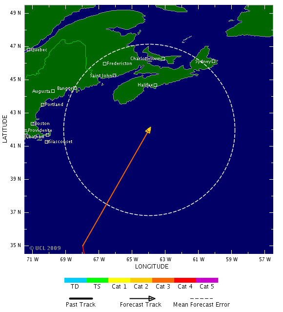
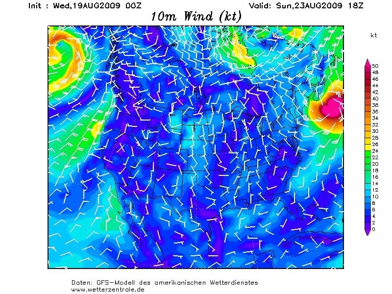
Inmiddels is een nieuw potentieel gebied vanuit Afrika overgestoken met potentie op meer. Volgens het ECMWF model, het enige model dat Bill al vroeg liet afbuigen naar het noorden en daarmee dus gelijk had, gaat ook dit systeem uitgroeien tot een orkaan en komt het systeem veel meer naar het Westen dan Bill. Eens zien of ze nu weer gelijk krijgen. Zo ja, dan kan het Caraibisch gebied zich op gaan maken voor de allereerste echte problemen van dit jaar.


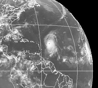
Afwachten dus... nog onzeker wat ie precies gaat doenquote:BILL NOW UP TO 140 MPH- A CATEGORY FOUR - WITH ROOM TO CONTINUE STRENGTHENING BUT WILL IT HIT LAND?
Bill has ramped up its intensity since yesterday and is now a sold category four hurricane. Top winds are near 140 mph and are forecast to reach a little higher. It will not be until Bill interacts with an upper level trough and cooler sea surface temps that it will begin to weaken. For now, it will continue to generate enormous waves and send them out across the Atlantic.
Obviously everyone wants to know where Bill is headed. For now, it looks very promising that it will not directly impact the Lesser Antilles as it should move past their latitude later today. Bermuda is seemingly next in line to have to potentially deal with Bill but the latest track models have shifted west even more- taking Bill WEST of Bermuda and closer to the NC Outer Banks.
One of the models, the UKMET, puts Bill at 70.7W and 32.8N over the weekend as the hurricane feels the effects of a rather deep low pressure area carved out in the upper atmosphere. This will more than likely turn Bill north and then northeast. The big issue is when this happens and how sharp a turn away from the coast Bill will have.
Other models are out near 68W and keep the hurricane far enough off New England to spare them a direct hit. However, Bill will likely grow in size and could still bring strong winds and dangerous seas to the Northeast and the Canadian Maritimes. I would be most concerned about Nova Scotia and Newfoundland right now but Cape Cod and vicinity is within the 5-day cone of uncertainty. It is still possible for Bill to adversely affect New England or even points south. The key will be the next 48 hours and how far west Bill gets before it stops gaining longitude. If it gets back as far as 72 or 73 west at 35 north, then we are in for some major problems along the U.S. coast. As it stands now, the odds still favor a good miss but those odds are dwindling just a little with each passing day.
Die hoge golven... hoe hoog zou dat zijn??
Ik lees overal tussen een 6 meter en 12 meterquote:Op woensdag 19 augustus 2009 15:00 schreef Frutsel het volgende:
[..]
Die hoge golven... hoe hoog zou dat zijn??
Bovenop de normale golfhoogte?quote:
[..]
Ik lees overal tussen een 6 meter en 12 meter

Qua golfhoogte... hier zie je de zwelling in de golven door Bill
https://www.fnmoc.navy.mil/ww3_cgi/cgi-bin/ww3_loop.cgi?color=w&area=natl&prod=swl_wav_ht
https://www.fnmoc.navy.mil/ww3_cgi/cgi-bin/ww3_loop.cgi?color=w&area=natl&prod=swl_wav_ht
Bill's big wavesquote:
Large swells from Bill will begin impacting the U.S. East coast from Florida to Maine beginning Friday night or Saturday morning. Seas will build to 5 - 10 feet in the offshore waters from central Florida northwards to South Carolina, and to 10 - 15 feet from North Carolina to Cape Cod. Near shore, waves will be about 40% less. This will cause a significant coastal erosion event along some portions of the coast. The latest run of the NOAA Wavewatch III model suggests that significant wave heights near Bill's center will reach 50 feet on Sunday. Since maximum wave height is typically about a factor of 1.9 greater than the significant wave height (which is the average trough-to-crest height of the top 1/3 largest waves), a few huge waves near Bill's center may reach 95 feet high.
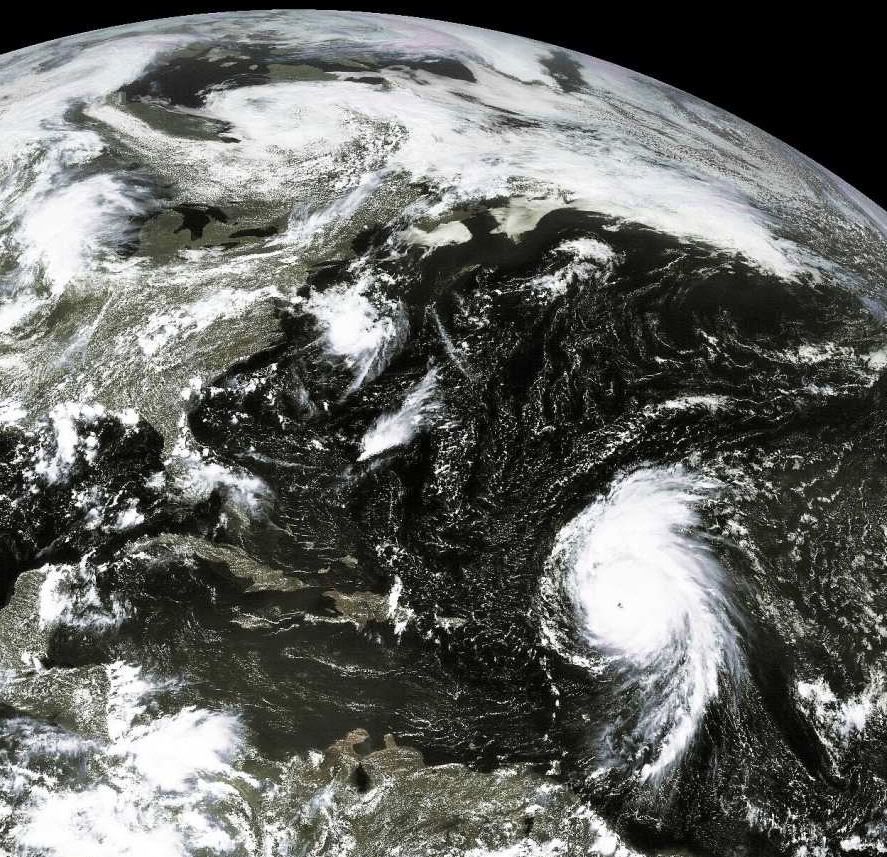

95 feet is bijna 30 meterquote:Op woensdag 19 augustus 2009 23:28 schreef Co_OL het volgende:
[..]
Bill's big waves
Large swells from Bill will begin impacting the U.S. East coast from Florida to Maine beginning Friday night or Saturday morning. Seas will build to 5 - 10 feet in the offshore waters from central Florida northwards to South Carolina, and to 10 - 15 feet from North Carolina to Cape Cod. Near shore, waves will be about 40% less. This will cause a significant coastal erosion event along some portions of the coast. The latest run of the NOAA Wavewatch III model suggests that significant wave heights near Bill's center will reach 50 feet on Sunday. Since maximum wave height is typically about a factor of 1.9 greater than the significant wave height (which is the average trough-to-crest height of the top 1/3 largest waves), a few huge waves near Bill's center may reach 95 feet high.
en dat van alleen wind, geen aardbeving of zo. Gelukkig hebben ze dan ook niet de diepgang van een tsunami, want dan zou het een echte ravage worden.quote:
Bill inmiddels gedowngrade naar Cat.3 lees ik net
quote:BILL FORECAST TO MAKE LANDFALL IN NOVA SCOTIA AFTER PASSING FAIRLY CLOSE TO NEW ENGLAND- BUT HOW CLOSE?
There is not a lot of new info tonight, nothing unexpected, concerning Bill. The latest forecast brings the hurricane inland over Nova Scotia Sunday and then Newfoundland on Monday. This would likely be a very bad event for them as Bill will pass over very warm water even as it turns north in a couple of days. People in the Canadian Maritimes need to begin thinking about their hurricane preparedness plans now. This has the potential of being a severe event for that region.
First Bill must pass Bermuda and should do so to the west- hopefully enough so that the worst effects are kept over the ocean. From there, it all depends on how far north and west Bill tracks before fading east towards the Maritimes. Only a small portion of New England is within the cone of uncertainty now which is good news. I think we have about 48 more hours until we will know whether or not New England will have to deal with hurricane conditions or just a breezy day. One thing is certain, large and dangerous waves are heading for land. Surfers will like this but everyone should be very careful out there. Please be sure to monitor your LOCAL beach conditions- when in doubt, ask a lifeguard or call your local NWS office. I'll have more here tomorrow morning and will decide at that point whether or not we will be taking a trip to Cape Cod for a meeting with Bill this weekend
Als Bill bij Nova Scotia aankomt is het ws een tropische storm geworden... Zal wel mee gaan vallen dus Maarrrr hoe zit het met Bermuda?
Bermuda krijgt, aldus de laatste berichten, niet de volle laag, maar zeker wel enkele uitwassen van de storm. Laat staan, metershoge golven 
Ik denk dat een gedeelte van de Oostkust van de U.S. ook het nodige gaat mee krijgen. New York etc...daar gaat ie bijna net zo rakelings langs als langs Bermuda.quote:Op donderdag 20 augustus 2009 11:16 schreef Frutsel het volgende:
Bermuda krijgt, aldus de laatste berichten, niet de volle laag, maar zeker wel enkele uitwassen van de storm. Laat staan, metershoge golven
Mwah... manhattan zit vast te wachten op golfjes van 30 mquote:
[..]
Ik denk dat een gedeelte van de Oostkust van de U.S. ook het nodige gaat mee krijgen. New York etc...daar gaat ie bijna net zo rakelings langs als langs Bermuda.
lijkt me vrij nihili die kansquote:
Zou het nog kunnen dat Bill zich bedenkt en alsnog over de golf van mexico gaat?
Ik hoop op het nieuwe onweersfront boven Afrika.. Bill is wel een gave orkaan, maar de trekrichting is gewoon jammer. Misschien krijgen wij over een week of 2 nog wel een laatste vleugje van Bill mee in Europa.
's Avonds een man, overdags rustig an
quote:Bill's waves
Hurricane Bill is generating huge waves, thanks to its enormous size and major hurricane intensity. Bill passed about 75 miles southwest of Buoy 41044 this morning, and the buoy recorded sustained winds of 67 mph, gusting to 92 mph, with a significant wave height (the height of the average 1/3 highest waves) of 38.8 feet. Output from NOAA's Wavewatch III model suggests that significant wave heights near Bill's center will peak at 50 feet by Saturday. Large swells from Bill will reach Bermuda this afternoon, increasing seas to 5 - 9 feet, according to the Bermuda Weather Service. Seas will increase to 10 - 20 feet on Friday and 20 - 30 feet on Saturday as Bill makes its closest approach to the island.
In the U.S., Bill's swells will reach New York's Long Island on Friday afternoon, and seas will build to 7 - 10' on Saturday and 12 - 16' on Sunday in the near shore waters. By Friday night, Bill's swells will be affecting the entire U.S. East Coast from Florida to Cape Cod. Maximum sea heights in near shore waters over the weekend will be about 7' from Florida to South Carolina, 11 - 14' along the North Carolina coast, 8 - 11' along the mid-Atlantic coast, and 10 - 11' along the coast of Maine. The highest waves along the U.S. coast will occur at Cape Cod, Massachusetts, where waves of 18 - 23' are being forecast by NOAA for Sunday. Bill's high waves are going to cause millions of dollars in erosion damage and create very dangerous rip currents and swimming conditions along the coast.
quote:AMAZING FORECAST FOR BILL SO FAR BUT THE EFFECTS WILL BE WIDESPREAD
The NHC has done quite an incredible job with the forecast for Bill. It has not pulled any suprises and seems to be following pretty much what was predicted by the folks in Miami. The hope is, obviously, that this will continue and Bill will not have the kind of impact that it is capable of. None the less, [b]the effects from Bill will be felt far and wide and I am not kidding about this.
Huge waves will impact Bermuda soon followed by a great deal of the Atlantic side of North America. In some place that typically have erosion problems, ocean overwash is coming. Houses and other structures already too close to the water will be in even more peril. All of this without the hurricane making a direct hit. It is that kind of hurricane that we are dealing with. For folks in Bermuda, Bill will pass well to the west but its huge size will still spread rain and wind with flooding storm surge-like wave action. I have not seen an Atlantic hurricane like this in a long time.
Once past the latitude of Bermuda, Bill should start to turn more northward and then east of north. When this happens is so critical to what effects are felt in New England and the Canadian Maritimes. So far, the NHC track has remained well offshore of New England but even there, large waves will do damage to the coastline.
Bill is een rare orkaan... Als hij landfall maakt in Nova Scotia is het nog steeds een categorie 1 als ik het goed zie. Is er ooit wel eens een orkaan categorie 1 in Canada geweest? En wij krijgen volgende week donderdag en vrijdag ook rotweer, zelfs als hij in Ierland / Noord Engeland aan land komt schijnt het nog een (sub)tropische storm te zijn!
Jep, Hurricane Kyle vorig jaar nogquote:
Bill is een rare orkaan... Als hij landfall maakt in Nova Scotia is het nog steeds een categorie 1 als ik het goed zie. Is er ooit wel eens een orkaan categorie 1 in Canada geweest? En wij krijgen volgende week donderdag en vrijdag ook rotweer, zelfs als hij in Ierland / Noord Engeland aan land komt schijnt het nog een (sub)tropische storm te zijn!
40.000 huishoudens zonder stroom, 10 miljoen dollar schade
Hurricane Kyle
quote:Orkaan Bill in Canada
MIAMI - De orkaan Bill heeft maandagochtend de kust van de provincie Newfoundland in het uiterste oosten van Canada bereikt. Dat heeft het Amerikaanse orkanencentrum in Miami gemeld. De stormwind trekt nu over het zuidoostelijke deel van Newfoundland
De golven die met de hevige wind gepaard gingen, hebben in de staat Maine in het noordoosten van de Verenigde Staten een meisje van 7 jaar het leven gekost. President Barack Obama stelde zondag zijn vakantie op het eiland Martha's Vineyard voor de Amerikaanse oostkust enkele uren uit, totdat de orkaan was voorbijgetrokken.
Bill is de eerste Atlantische orkaan van dit jaar. De wervelstorm valt in categorie 1 van de zogeheten Saffir-Simpsonschaal, die wordt gebruikt om de kracht van orkanen te meten. Dat betekent dat de orkaan zwak is en lichte schade aanricht. Vorige week was Bill nog een orkaan van de vierde categorie, het op een na hoogste niveau.
Gaat Bill de hele tocht terug over de Atlantic overleven als Tropische storm?
Dan gaan we d'r vast nog iets van meekrijgen? Ierland in elk geval

quote:NOW THAT BILL IS GONE, WHAT'S NEXT?
The NHC is no longer issuing advisories on Bill as the system has transformed in to a non-tropical type of ocean storm. The one-time category four hurricane certainly left its mark throughout the western Atlantic Basin and will be remembered for a while to come I am sure. So what's next?
It is still only late August and we have a lot of hurricane season left to deal with. In fact, there is likely more activity brewing now that could impact the weekend ahead. A large area of clouds, showers and thunderstorms is slowly organizing a few hundred miles east of the Lesser Antilles. This is associated with a tropical wave that flared up several days ago and then died off.
Now that Bill has cleared the pattern, the tropics are conducive for development again. A look at the usual global computer models suggests that we will see the development of a tropical depression somewhere near the Bahamas in about 72 hours- maybe less. None of the models show the system getting very strong which is good news.
As is always the case, we'll just have to watch and see how things unfold with the upper air pattern and steering currents. I would say it is a safe bet that unsettled weather will be the rule in the SW Atlantic by mid-week. Water temps in the region are very warm and mostly undisturbed so there is potential for tropical cyclone formation in this region. Also of note, the GFS, which handled the genesis of Bill to near perfection, is showing another Cape Verde system getting organized over the next 3-5 days. Other models are not as aggressive as the GFS but its run to run consistency is picking up a little.
We would expect to see development just about anywhere in the Atlantic at this point so it is nothing to be alarmed about. We remain in an active pulse period with favorable conditions in many areas. Just keep aware of the latest goings on and we'll keep posting new info as it comes in
quote:Dodental in Taiwan blijft oplopen
TAIPEI - De tyfoon Morakot, die Taiwan eerder deze maand trof, heeft inmiddels aan 376 mensen het leven gekost. Meer dan 250 mensen worden nog altijd vermist. Dat heeft de Taiwanese regering dinsdag gezegd.
Maandag ging Taiwan nog uit van 292 doden en bijna vierhonderd vermisten. Bijna alle slachtoffers komen uit het zuidelijke dorp Hsiaolin, dat tijdens het noodweer werd bedolven onder een modderstroom.
Op de puinhopen zal een herdenkingspark worden aangelegd. Het dorp zelf zal niet worden opgegraven, maakte de burgemeester maandag bekend.

quote:Tropical wave (92L) with an increasing amount of heavy thunderstorm activity is located a few hundred miles northeast of Puerto Rico, and is tracking west-northwest at 20 mph. Recent visible satellite imagery shows some increased organization of the storm, with upper-level outflow on the north side and a hint of a surface circulation trying to form near 22N 62W. However, the disturbance is moving underneath an upper-level cold-cored low pressure system, and this upper-level low is generating 20 - 30 knots of wind shear due the strong upper-level winds from the west. The upper low is also dumping cold, dry air into 92L, and this is retarding development of the storm. Dry air is getting ingested into 92L's thunderstorms and creating strong downdrafts that are robbing 92L of heat and moisture. These downdrafts are creating surface arc clouds that spread out from where the downdraft hits the ocean surface (Figure 1). Nevertheless, 92L appears determined to become a tropical depression over the next day or two, and NHC is giving 92L a high (greater than 50% chance) of developing into a tropical depression by Thursday morning

HURRICANE DANNY!
En das dus geen grapje
Deze trekt ook weer richting de oostkust van Amerika. Ik ben benieuwd of het ook zo'n zware wordt als Bill was.quote:Op dinsdag 25 augustus 2009 16:12 schreef Frutsel het volgende:
[..]
[ afbeelding ]
HURRICANE DANNY!
En das dus geen grapje
[ Bericht 0% gewijzigd door #ANONIEM op 25-08-2009 18:51:27 ]
Idd... weer de oostkustquote:92L CLOSE TO BECOMING A DEPRESSION AND MOST LIKELY A TROPICAL STORM
The first good visible satellite photos of 92L show that it has developed a low level circulation but lacks deep thunderstorms all the way around that center. Strong winds are blowing the convection off to the west but this is likely to let up just enough to allow this to become our next named storm: Danny. The Hurricane Hunters are out there now investigating and we may have a new storm to track within the next couple of hours. The forecast from the various computer models is interesting to say the least. It is possible that this system will have a direct impact on the North Carolina coast and then farther north this weekend. The UKMET, ECMWF and Canadian CMC all show this coming far enough west to either clip Cape Hatteras or maybe go just west of there as it heads northward. People from the NC coast all the way to New England need to be watching this closely- a weekend tropical storm threat in late August is nothing to take lightly. In fact, some of the intensity guidance strongly suggests that this could make it to hurricane strength WHILE MOVING NORTH past the NC Outer Banks. Water temps are very warm all the way up to just off the coast of New York- so it would not suprise me at all to see this become a serious threat to the East Coast. How much so remains tough to call right now.
En daar is Danny. En weer gaat die TS/Orkaan de verkeerde kant op. Helaas.
's Avonds een man, overdags rustig an
Hij gaat wel erg dicht langs de Oostkust.
Straks hebben we een Landfall tussen Washington en New York.
Straks hebben we een Landfall tussen Washington en New York.
quote:People living along or planning to visit the East Coast this weekend will need to pay close attention to newly formed Tropical Storm Danny. Danny is expected to track near the coast of the mid-Atlantic and New England Friday night into the weekend.
Tropical Storm Danny formed late Wednesday morning to the east of the Bahamas, making it the fourth named storm of the 2009 Atlantic Hurricane Season. Danny will track northwestward through Thursday, staying east of the Bahamas.
The storm will then take a turn more toward the north Friday before curving to the northeast over the weekend. This path puts areas from the North Carolina coast to New England at risk.
As the storm moves over warmer waters and into weaker wind shear Thursday into Friday, it is expected to strengthen into a hurricane by the early part of the weekend.
The forecast path released by the AccuWeather.com Hurricane Center continues to show Danny passing just east of the Outer Banks of North Carolina Friday night before strengthening into a hurricane and making landfall over Long Island or southeastern New England late Saturday or Saturday night.
There is still a chance that Danny tracks farther west, moving over the Outer Banks. There is also a chance the storm heads farther to the east like Bill, missing New England and never making landfall along the East Coast.

Dat onweerscomplex ten westen van Afrika dooft al uit volgens mij.. Maar die andere 2 complexen zien er goed uit. Ben benieuwd .
's Avonds een man, overdags rustig an
Handig die knip tool in Windows 7 (vista)quote:
Danny ten westen van Afrika ook nog niks en is nu toch een naam geworden
Danny zal denk ik niet aan land gaan. Gelukkig ook maar. Zie je het al voor je een Cat. 3 of hoger die vol New York raakt. 
Dat geval wat nog bij Afrika is kan nog wel gevaarlijk worden.
Gelukkig leeft het seizoen nu weer een beetje maar het is wel een rustig jaar. ( tot nu toe )
Volgend jaar ligt El Nino toch in Atlantic?
Dat wordt nog leuk dan.
Dat geval wat nog bij Afrika is kan nog wel gevaarlijk worden.
Gelukkig leeft het seizoen nu weer een beetje maar het is wel een rustig jaar. ( tot nu toe )
Volgend jaar ligt El Nino toch in Atlantic?
Dat wordt nog leuk dan.
Als ik dat pad zo zie...krijgt Manhattan dan een cat.1 hurricane?
Hij gaat er nu nog redelijk langs... maar d'r zal zeker overlast komen en als hij nog meer naar links afbuigt richting Boston/NY wordt het echt een drama daar
Een cat.1 storm daar kan je vergelijken met een cat.3 storm in Miami.
Hij gaat er nu nog redelijk langs... maar d'r zal zeker overlast komen en als hij nog meer naar links afbuigt richting Boston/NY wordt het echt een drama daar
Een cat.1 storm daar kan je vergelijken met een cat.3 storm in Miami.
Tot nu toe zal hij alleen er net langs gaan. En de windfield zal rechts van de storm liggen dus niet over Amerika.quote:Op donderdag 27 augustus 2009 10:47 schreef Frutsel het volgende:
Als ik dat pad zo zie...krijgt Manhattan dan een cat.1 hurricane?
Hij gaat er nu nog redelijk langs... maar d'r zal zeker overlast komen en als hij nog meer naar links afbuigt richting Boston/NY wordt het echt een drama daar
Een cat.1 storm daar kan je vergelijken met een cat.3 storm in Miami.
Hoe zit het met het getijde dan?
De zogeheten Stormsurge + een hoogtij kan dan toch nog behoorlijke overlast veroorzaken lijkt me?
De zogeheten Stormsurge + een hoogtij kan dan toch nog behoorlijke overlast veroorzaken lijkt me?
Ja het water kan tuurlijk wel een probleem worden. Maar zullen wel zien. Hopelijk gaat hij niet aan land.quote:Op donderdag 27 augustus 2009 11:44 schreef Frutsel het volgende:
Hoe zit het met het getijde dan?
De zogeheten Stormsurge + een hoogtij kan dan toch nog behoorlijke overlast veroorzaken lijkt me?
el Nino is er nu... en heeft een negatief effect op orkanen. Dit jaar veel minder orkanen door El Nino.quote:
Volgend jaar ligt El Nino toch in Atlantic?
Dat wordt nog leuk dan.
Zie hier of
El Niño: Terug van weggeweest?
quote:The worst effects from Danny will be in the Northeast Saturday, where it will interact with a storm arriving from the Midwest. The two systems will combine forces to ruin outdoor plans for the second weekend in a row.
Danny, at present, is a weaker and much slower-moving tropical system compared to Big Bill last weekend. However, Danny will strengthen, causing wind, waves and rain to increase as he moves northward on a path closer to the coast compared to Bill.
AccuWeather.com Meteorologists expect Danny curve to the northeast this weekend. A track to the east of Cape Hatteras, N.C. is anticipated early Saturday morning. However, he could still pass very close to or right over Cape Cod, Nantucket or Martha's Vineyard, Mass. Saturday evening.
Most of the rain and thunderstorms that occur Friday over the mid-Atlantic will be from the Midwest storm, rather than Danny. Rain from the Midwest storm and Danny will not reach New England until Friday night.
The combination of Danny and the storm approaching from the Midwest will bring locally heavy rain and a flooding threat to portions of New England and the northern part of the mid-Atlantic Friday night into Saturday.
Increasing winds will lead to building waves, beach erosion and dangerous rip currents that can last through Sunday from the Outer Banks of North Carolina to Nova Scotia and Newfoundland.
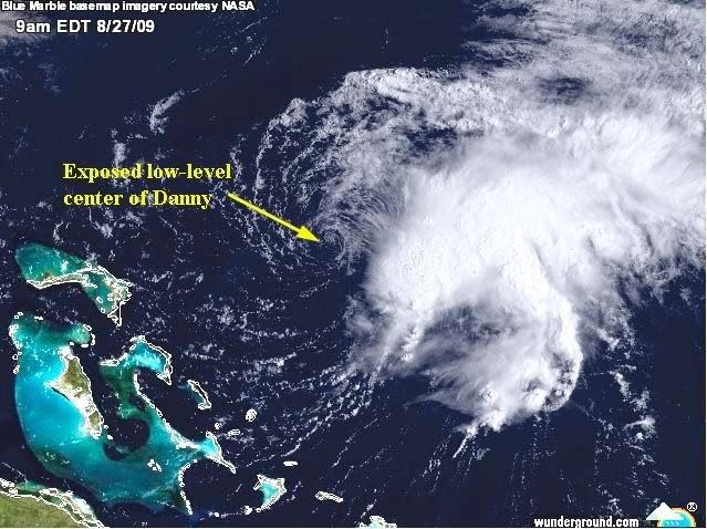
Invest 94
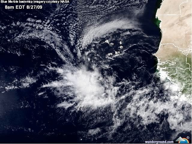
Danny dooft uit
quote:I THINK IT IS PRETTY MUCH ALL OVER FOR DANNY- GREAT NEWS FOR THE EAST COAST
A quick update here after looking over some of the very latest data on Danny. I think the NHC is right on track with forecasting what will amount to be a very weak tropical storm moving roughly parallel to the East Coast of the U.S. It will probably induce some pretty good rains as all of the energy from the tropics and the upper level support coming in from the Midwest all combine/interact this weekend. There will be some waves and the threat of rip currents once again so please be careful out there. Otherwise, Danny will most likely go down as a major underachiever- which ends up spelling great news for residents and visitors to the East Coast. It could transition in to quite the summertime Nor'easter and folks in Nova Scotia should be ready for some foul weather this weekend. Our attention will quickly turn to 94L which has all the makings of becoming our next named storm- but it poses absolutely no threat to land areas anytime soon.
Een categorie gaat het blijkbaar niet meer worden.quote:
94L lijkt ook weer dezelfde kant optegaan. Kan nog alle kanten op natuurlijk.
Ik ben ook benieuwd naar dat gebied ten oosten van de Antillen.
's Avonds een man, overdags rustig an
quote:Hurricane Jimena will threaten Cabo San Lucas and southern Baja California, Mexico, with hurricane conditions late Monday through Tuesday. Jimena has quickly become a large and powerful hurricane, reaching Category 4 strength Sunday morning. She was located about 515 miles south-southeast of the southern tip of Baja California. Winds had increased to 135 mph.
Squalls associated with Jimena will continue to affect the southwestern Mexican state of Jalisco. The weather in Cabo San Lucas and the rest of the southern Baja California will be hot and mostly dry today. Conditions will deteriorate on Monday. The outer rain bands will begin to affect the southern Baja. Hurricane-force winds will develop Tuesday. Winds over 100 mph are possible in Cabo San Lucas and the rest of the southern Baja Tuesday afternoon and Tuesday night.
In addition to the powerful winds, very heavy rain is also expected. The southern Baja is basically a desert, so heavy rain can quickly lead to flash flooding. A storm surge of more than 10 feet is possible as well.
Orkaan Jimena raast op Mexicaanse kusten af
Jimena, een orkaan van categorie 4 en dus "extreem gevaarlijk", heeft in de Stille Oceaan nog aan kracht gewonnen en bevindt zich momenteel op 400 km van de Mexicaanse kusten die hij dinsdag mogelijk bereikt, meldt de nationale meteorologische dienst van Mexico.
Tot 270 kilometer per uur
Jimena brengt rukwinden mee van 220 km/h en windstoten tot 270 km/h. Als Jimena op deze koers blijft, bereikt de orkaan dinsdagochtend mogelijk de Pacifische kust van de Mexicaanse deelstaat Neder-Californië. De meteorologische dienst waarschuwt de bevolking dan ook voor overstromingsgevaar en grondverschuivingen. (belga/vsv)

Wervelstorm trekt richting Tokyo
De wervelstorm Krovanh, die ontstaan is boven de Stille Oceaan, wordt vergezeld van rukwinden tot 80 knopen (144km/h). Vanochtend bevond hij zich bij het Japanse eiland Chichi-Jima en nu begeeft hij zich dus richting noordnoordwesten met een snelheid van 30 km/h.
Hoge golven
Volgens het instituut zou de cycloon maandagnamiddag Tokyo naderen. Het instituut voorspelt dan ook felle regen over de hoofdstad en waarschuwt voor harde wind en hoge golven.Krovanh zou Japan, dat vandaag een nieuw Lagerhuis kiest, een aantal uren na het sluiten van de stembussen moeten bereiken. (afp/eb)

PREPARATIONS TO PROTECT LIFE AND PROPERTY SHOULD BE RUSHED
TO COMPLETION.
Dat klinkt niet goed. Wat een monster is dit zeg!
TO COMPLETION.
Dat klinkt niet goed. Wat een monster is dit zeg!
's Avonds een man, overdags rustig an
Stevig beestje, is dit juist niet iets zeldzaams (tegenover de golf van Mexico) een CAT-5. Ik kan me zoiets niet voor de geest halen qua trajectorie.
http://en.wikipedia.org/w(...)5_Pacific_hurricanesquote:Op dinsdag 1 september 2009 00:31 schreef Drugshond het volgende:
Stevig beestje, is dit juist niet iets zeldzaams (tegenover de golf van Mexico) een CAT-5. Ik kan me zoiets niet voor de geest halen qua trajectorie.
http://en.wikipedia.org/wiki/Hurricane_Linda_(1997)

quote:Orkaan Jimena op weg naar Mexico
LOS CABOS - Orkaan Jimena is in de nacht van maandag op dinsdag aangezwollen tot een storm van categorie vijf, de zwaarste schaal om de kracht van orkanen te meten. Dat heeft het Amerikaanse orkanencentrum in Miami gemeld.
Jimena is met windsnelheden van 250 kilometer per uur op weg naar Mexico, maar zal naar verwachting niet meer zo sterk zijn als de storm dinsdagavond aan land komt. Dat gebeurt vermoedelijk in Baja California.
Toeristen in dat gebied besluiten veelvuldig hun vakantie vroegtijdig af te breken. De vakantiegangers vrezen dagen vast te zullen zitten zodra de orkaan aan land komt. De autoriteiten hebben de inwoners van het gebied opgeroepen zich zo goed mogelijk voor te bereiden op de komst van Jimena. Tienduizend mensen zijn geëvacueerd.
Overstromingen
Er wordt naast de stevige wind ook veel regen voorspeld. Door de droogte van de afgelopen tijd kan de grond de regenval waarschijnlijk niet aan, waardoor ook gewaarschuwd wordt voor overstromingen.
De haven van Cabo San Lucas is uit voorzorg gesloten, hoewel de orkaan daar waarschijnlijk niet overheen zal razen. Ook is een top van de de Organisatie voor Economische Samenwerking en Ontwikkeling (OECD) verplaatst van Los Cabos naar Mexico-Stad.
Het is nu weer een 4, maar het was gisteravond een 5 volgens mij. Dat was de verwachting ook, dat ie iets af zou zwakken voordat het land bereikt werd.
Volgens Wunderground is het nog steeds een categorie5. (155 mph = categorie5).
Wel precies op het randje, maar het is een cat 5.
[ Bericht 30% gewijzigd door #ANONIEM op 01-09-2009 15:31:58 ]
Wel precies op het randje, maar het is een cat 5.
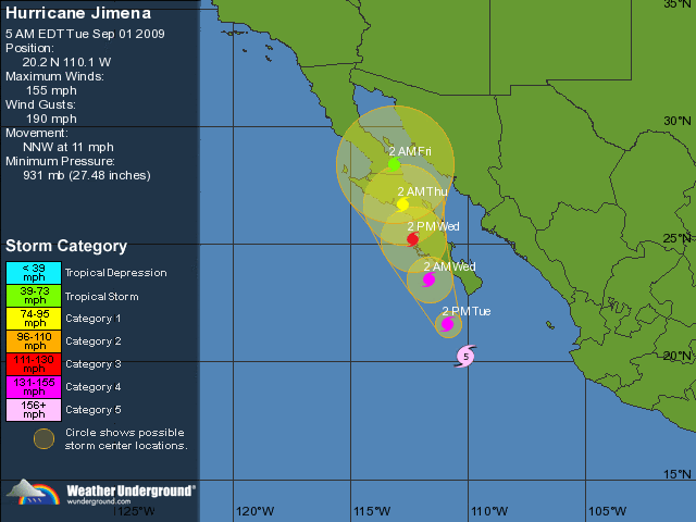
[ Bericht 30% gewijzigd door #ANONIEM op 01-09-2009 15:31:58 ]
Jep...El Nino heerst ook in de Atlantic... niet in de Pacificquote:
El Niño was ongunstig voor orkanen toch
Ook niet in de golf van mexico?quote:Op dinsdag 1 september 2009 15:38 schreef Frutsel het volgende:
[..]
Jep...El Nino heerst ook in de Atlantic... niet in de Pacific
Ik zeg het net wat krom 
El Nino slaat toe in de Pacific, daardoor zijn er minder orkanen in de Atlantische Oceaan en het Caraibische Gebied.
El Nino zelf komt niet voor in de Atlantische oceaan, maar is een Pacifisch verschijnsel dat de Atlantische oceaan beïnvloed. Eigenlijk beinvloedt het het weer overal ter wereld wel iets
El Niño: Terug van weggeweest?
Tijdens een el-nino is het water aan de westkust van Zuid Amerika en Noord Amerika warmer dus meer kans op orkanen. Tijdens non-el-nino jaren is dat effect dus veel minder aan de westkust, terwijl de Atlantic dan meer kans heeft op warmer zeewater en dus meer orkanen daar.
Ach de Noordzee is ook de Atlantic, dus de Golf van Mexico ook.quote:
Het was de zomer van 1969
Ik weet het nog zo goed
Het fietsenhok was leeg
Ik weet het nog zo goed
Het fietsenhok was leeg
Noordzee is 18 a 19 graden, golf van Mexico 32+quote:Op dinsdag 1 september 2009 16:40 schreef Fappie het volgende:
[..]
Ach de Noordzee is ook de Atlantic, dus de Golf van Mexico ook.
Ik ben op zoek geweest naar een beetje aardige webcam/stream maar helaas vrij weinig boeiends kunnen vinden.
http://www.cabovillas.com/campage.asp?id=2 heeft wel een aardig plaatje maar deze refreshed bijna niet.
http://www.cabovillas.com/campage.asp?id=2 heeft wel een aardig plaatje maar deze refreshed bijna niet.
Always & Never
Even copy paste van een Mexicaanse nieuwssite:
Baja California Sur en emergencia por el huracán ‘Jimena’
México, 1 Sep (Notimex).- Ante el inminente impacto del ciclón tropical ‘Jimena’ en las próximas 24 horas, la Coordinación General de Protección Civil emitió una declaratoria de emergencia para los municipios de Los Cabos, La Paz y Comondú, en Baja California Sur.
El organismo dependiente de la Secretaría de Gobernación, informó en un comunicado que ante el posible impacto del fenómeno natural, se activaron los recursos del fondo revolvente del Fondo de Desastres Naturales (Fonden), para brindar ayuda inmediata a la población damnificada.
A partir de esta declaratoria, solicitada por el gobierno estatal, las autoridades contarán con los recursos del Fonden para atender las necesidades alimenticias, de abrigo y de salud de la población que resulte afectada.
Voor degenen die geen Spaans kunnen in het kort: De autoriteiten hebben een speciaal fonds opgericht om paraat te staan aan de provincie Baja California Sur tijdens en na de orkaan die binnen 24 uur aan land komt. Het overheidsorgaan belooft directe hulp in de vorm van voedsel, tijdelijke huisvesting en medicijnen voor alle getroffen gebieden.
Nou, dat gaat absoluut spoken daar.
Met een Cat 3 aan land......
ff een google maps linkje erbij gezocht.
http://maps.google.nl/?ie=UTF8&ll=24.856534,-112.005615&spn=4.365412,6.932373&t=h&z=7
Kan alleen nog geen webcam erbij vinden.
ff een google maps linkje erbij gezocht.
http://maps.google.nl/?ie=UTF8&ll=24.856534,-112.005615&spn=4.365412,6.932373&t=h&z=7
Kan alleen nog geen webcam erbij vinden.
Het kon nog weleens druk gaan worden in de Atlantische Oceaan.
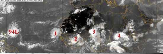
quote:Elsewhere in the tropics
It's September, the most active month for hurricane activity in the Northern Hemisphere. There's every indication that the 2009 Atlantic hurricane season will have an active first half of September, since SSTs are 0.5 - 1.0°C above average, wind shear is near average, and the African monsoon is sending a long parade of African waves spinning off the coast of Africa. An IR satellite image from noon today shows this activity well (Figure 2). We can see a line-up of five African waves stretching from the Lesser Antilles to eastern Africa. The GFS model develops the waves numbered "2" and "3" into tropical depressions next week, and the waves labeled "1" and "4" also have a chance to develop into tropical depressions, as well. The wave labeled "1" is mentioned on NHC's Tropical Weather Outlook as having a low (less than 30%) chance of developing into a tropical depression by Thursday. This wave is under a moderate 10 - 15 knots of wind shear, and is over sufficiently warm waters (27 - 28°C) that some development may occur this week. The wave is far enough north that it will be hampered by dry air from the Sahara Desert.
quote:LOS CABOS, Mexico — Hurricane Jimena weakened to a Category 2 storm as it bore down on the coast of Mexico's Baja California peninsula.
Jimena's maximum sustained winds decreased late Tuesday to near 110 mph and the National Hurricane Center in Miami said it was expected to weaken further before making landfall Wednesday.
Jimena's change in status came a day after the hurricane brushed passed the resort towns at the southern tip of the Baja California, lashing them with driving rain and winds.
Despite the pummeling by the fringes of the then-Category 3 hurricane, the Mexican peninsula's biggest resort, Los Cabos, appeared to be escaping major damage beyond power outages and mud-choked roads.
Dozens of people evacuated from the Los Congrejos shantytown huddled in darkened rooms at a school after electricity failed during the storm. Trying to calm squalling babies and ignore hunger, the evacuees waited for dawn, and a chance to look at what the hurricane did to their homes made of plastic sheeting, wood and tar paper.
"Instead of giving out a few sheets of roofing every year, they should give us materials to build real houses — wood, or even bricks," said Paulino Hernandez, an out-of-work mason who sought haven at the school. "Every year it's the same thing: They (officials) give out a few sheets of roofing, and the next year it has to be replaced" when a hurricane comes.


quote:Aanzienlijke schade door Jimena
De orkaan Jimena heeft op het Mexicaanse schiereiland Neder-Californië aanzienlijke schade aangericht en mogelijk ook een eerste slachtoffer gemaakt. De civiele bescherming meldt dat een visser vermist is opgegeven.
"Er is een persoon vermist opgegeven in de gemeente San Buto", op ongeveer 200 km ten noorden van de zone waar de orkaan gisteren de kust bereikte, aldus een woordvoerder van de civiele bescherming. "Het gaat om een visser die sinds dinsdag niet meer gezien is. Het is niet duidelijk of hij door een stortvloed is meegevoerd of dat hij zich op zee bevond."
De orkaan heeft tientallen huizen verwoest. Meerdere dorpen en steden kwamen zonder stroom te zitten, telefoonverkeer was op veel plaatsen onmogelijk en meerdere dorpen zijn door overstromingen van de buitenwereld afgesneden. (afp/adv)
quote:What is Erika gonna do
I cannot recall a more interesting situation as far as the future of a tropical storm like we are seeing with Erika right now. The NHC is continuing advisories on the poorly organized storm but looking at satellite pictures alone, you would think it was a well developed hurricane. The issue is, according to the latest discussions from the NHC, dry air and strong winds at just the right layers of the atmosphere.
These negative parameters are just enough to keep Erika firmly in check and may weaken it enough to be downgraded to a well defined tropical wave again. However, it is worth noting that the GFDL and HWRF models insist that Erika will become a major hurricane over the next five days as it travels just north of the Greater Antilles and towards the Bahamas.
What I do not understand is how these modern and seemingly reliable models can depict such a contrasting solution to what the NHC is forecasting: dissipation. Their reasoning has more to do with increasing strong winds aloft than anything- enough so that the official forecast calls for Erika to basically fade away as it travels west-northwest.
Yet, the GFDL and HWRF show robust intensification in to a strong hurricane along almost the same path that the NHC plots. So who will be right? The models or the humans? Computers are machines designed by people and so they are certainly prone to making mistakes- as we humans are. So it is likely that the human interpretation of the real world will win out and Eika will in fact die off and be of little concern to anyone. That is what seems most likely but it is not a guarantee. The old "what if?" keeps creeping in to my mind and believe me, Mike, Jesse and I have all talked about it at great length between yesterday and right now. Heck, even the Navy's NOGAPS model shows Erika making a comeback over a week from now with a strong storm or hurricane parked off the North Carolina coast.
So you see the dilemma that is inherent to this situation. I do not want to create something out of nothing when the people in charge of the forecasts present compelling evidence as to why this thing will die off. But so far, it is still there and looking fairly healthy considering the hostile environment. One thing is certain- unsettled weather will rule the picture over the Lesser Antilles and spread towards Puerto Rico today and tomorrow. Without this even having a name would not limit the heavy rains and gusty winds that are in store for much of the northeast Caribbean

quote:the center of Erika is exposed as a low-level swirl moving out ahead
of the waning deep convection over the Leeward Islands. The Air
Force Reserve reconnaissance hurricane hunter aircraft found a
minimum pressure of 1007 mb...but were unable to find any winds to
support tropical storm status. As a result...Erika is downgraded to
a tropical depression on this advisory.
The initial motion estimate is 280/10...well to the south of the
previous official forecast track and the majority of all the model
guidance. Since Erika should move with the low-level flow...the
shallow BAM model was followed closely for the new forecast track.
This forecast turns Erika toward the west-northwest...taking the
cyclone or its remnant low south of Puerto Rico and over Hispaniola
...Where the low-level center will likely dissipate over the rugged
terrain in 48 hours.
The official forecast assumes that Erika will have a difficult time
sustaining any deep convection as it moves into an environment of
increasing shear and dry air in the lower to mid-troposphere. Erika
is maintained as a tropical depression through 12 hours...and is
forecast to be a remnant low by 24 hours....although this could
occur sooner if the convection east of the low-level center over
the Leeward Islands continues to weaken. It is also possible that
the center of Erika could become poorly defined and the cyclone
could devolve into a tropical wave at any time. Even if Erika loses
tropical cyclone status...its remnants could produce heavy rainfall
over the Greater Antilles.
Forecast positions and Max winds
initial 03/2100z 16.7n 65.3w 30 kt
12hr VT 04/0600z 17.2n 66.8w 30 kt
24hr VT 04/1800z 18.1n 68.6w 25 kt...remnant low
36hr VT 05/0600z 18.9n 70.3w 20 kt...remnant low
48hr VT 05/1800z 19.5n 72.2w 20 kt...dissipating inland
72hr VT 06/1800z...dissipated
$$
forecaster Brennan
Er lijkt weer iets aan te komen vanaf Afrika.. Eens kijken of dit nu eens naar het westen gaat i.p.v. noorden.
's Avonds een man, overdags rustig an
tja... misschien dat dat Fred wordt, maar de condities zijn ongunstig om een lang leven te leidenquote:Weak season, but why?
The experts said that the hurricane season would likely be a weak one. So far, they have been spot on. Only hurricane Bill, which did become a category four, was much of a threat to anyone. Everything else has been about as poor as you could ever see from the tropics. But why has it been like this? One year ago we were tracking hurricane Ike which would go on to become a top-5 hurricane in United States' history. It came on the heels of hurricane Gustav which itself set records for wind speeds in Cuba. How can things be so dramatically different the very next year? Some blame it purely on El Nino but that is too simple. There are other larger forces at work here including cooler than normal sea surface temps in portions of the Atlantic where they need to be warmer in order to promote an unstable environment in which thunderstorms can develop and sustain. There is also a lot of sinking, dry air evident in the deep tropics, this too adds to the hostile conditions and goes strongly against development of tropical cyclones. Add to that what appears to be a weaker than normal Bermuda High, which allows strong upper level energy to dig off and near the East Coast, and you have the makings of a paltry hurricane season. Erika is a classic example of this even though some of the computer models insisted it would become a powerful hurricane. Those computer models are wrong, Erika is no longer a concern except for some rain associated with the low pressure trough that created it in the first place.
So what lies ahead for the rest of the season? It is only September 4 and yes, a lot can happen in the next six weeks or so that remains in the traditional meat of the season. We do see a few tropical waves across the eastern Atlantic that are moving westward in stealth mode- meaning they are essentially naked of any deep convection. They too will probably reach 50W longitude and begin to flare up, only to be snuffed out by hostile conditions. Of course, we know better than to completely dismiss the rest of the season as there is time for one to get through and ruin everything. In my opinion, the odds are against that happening but since we do not know for sure what lies ahead, we'll keep an eye out just in case
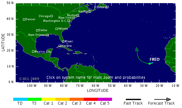
Behoorlijke pluk in de Golf van Mexico nu zelf. Heeft misschien ook nog wel potentie om te ontwikkelen tot Grace
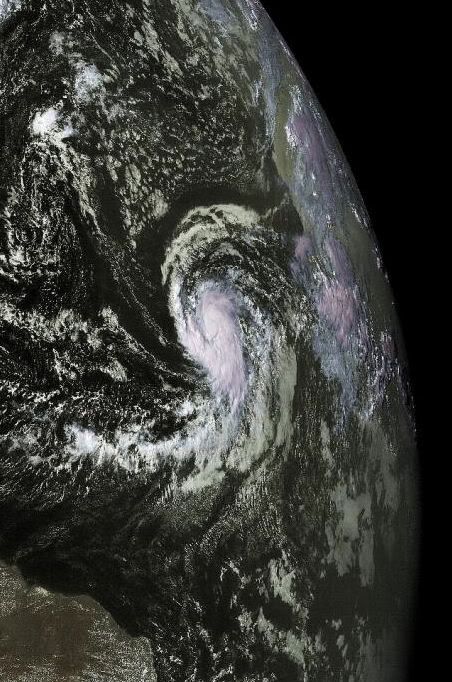
Zozo, Fred is inmiddels al cat. 3! Kan nog cat. 4 worden binnen 12 uur.
's Avonds een man, overdags rustig an
Uiteindelijk alleen maar goed nieuws natuurlijk als zowel Fred als Linda het land niet raken. Echter wil je stiekem natuurlijk ook mooie plaatjes zien. Maar van zowel Fred als Linda hoeven we niks bijzonders te verwachten denk ik. Hoogstwaarschijnlijk dat we van Fred in een latere vorm nog wat troep over ons land gaan krijgen.

Eind september misschien dus weer wat meer aktiviteit voor de Atlantische Oceaan/Golfregioquote:Meanwhile, hurricane Fred continues to move slowly in the eastern Atlantic as it also weakens due to fairly hostile conditions. The interesting the thing about Fred is that the GFS model in particular, which goes out to 384 hours on each run, shows Fred's remnant low pressure area coming all the way back to Florida in about 10-11 days. It shows up as a tropical wave really with not much energy but it is there. It would be quite remarkable if it were to hold together enough to be of concern.
One reason I am interested in this a little more than usual is due to a pattern change that appears to be coming. Right now, most of the Atlantic is quite unfavorable for tropical storm formation. This is due to strong winds in the upper layers of the atmosphere as well as sinking, converging air. To get tropical storms and hurricanes, you need to see air in the upper levels that is diverging or spreading out as we would see with a large upper anticylone.
The latest GFS MJO forecast, which goes out to 15 days, indicates that the current negative pattern will cease and switch to one that is quite a bit more favorable- right at the end of the month and in to early October. This has to be watched closely as it is my belief, based on looking at longer range models, that the Caribbean Sea and Gulf of Mexico could get more active in the coming weeks.
It makes sense too climatologically as we begin to shift away from the eastern Atlantic and focus more on the western Basin towards the end of September. Let me be clear- there are no indications that a hurricane is in the works for any location. As I talk about often, these are just pieces of a large puzzle that we try to put together to figure out the picture of what may lie ahead in the tropics. What I see is the chance of a more favorable development pattern evolving. Whether or not anything actually happens during that pattern remains to be seen.