WKN Weer, Klimaat en Natuurrampen
Lees alles over het onstuimige weer op onze planeet, volg orkanen en tornado's, zie hoe vulkanen uitbarsten en hoe Moeder Aarde beeft bij een aardbeving. Alles over de verwoestende kracht van onze planeet en tal van andere natuurverschijnselen.


quote:As far as the tropics go- we will end July without any issues what so ever. All is quiet and should remain that way for another week to perhaps 10 days. After the first week of August, I see a pattern change in the upper level wind flow that could allow for organized deep convection to begin flaring up in the Atlantic Basin. The tropical waves over Africa are strong and robust but the atmosphere over the eastern Atlantic has not been favorable to allow them to develop. There are signs in the longer range modeling that suggest this will change for a time beginning close to mid-August. For now, no problems exist in either the Atlantic or the east Pacific- so far so good.
quote:TROPICAL STORMS AND HURRICANES LIKELY TO BE SCARCE FOR A WHILE
From the looks of things, we will not see any tropical storms or hurricanes anytime soon. The pattern is still simply not conducive for any significant development. We are seeing quite a robust line of tropical waves emerge from the coast of Africa but hostile upper level winds and other factors are keeping them in check and not allowing them to grow and develop. I see nothing in the long range computer models to suggest a change anytime soon. After about August 10 or so, there may be a period of more favorable conditions but this remains to be seen

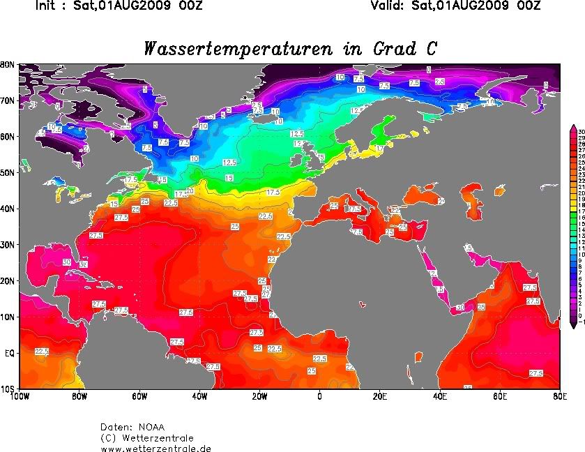
Hmmm er was toch een lage zeewatertemperatuur in de Atlantische oceaan ter hoogte van de evenaar toch?
Lage zeewatertemperatuur = minder kans op orkanen?
Lage zeewatertemperatuur = minder kans op orkanen?
Drugs are good mkay?
Meerdere oorzaken hebben d'r invoed op... maar dat is er idd één 
Maar je moet dan naar het water kijken vanaf de westkust van Afrika naar de Golf van Mexico, want daar zullen ze ontstaan. Daar is ook de wind van belang, bijv op de straalstroom enzo
Maar je moet dan naar het water kijken vanaf de westkust van Afrika naar de Golf van Mexico, want daar zullen ze ontstaan. Daar is ook de wind van belang, bijv op de straalstroom enzo
Iddquote:
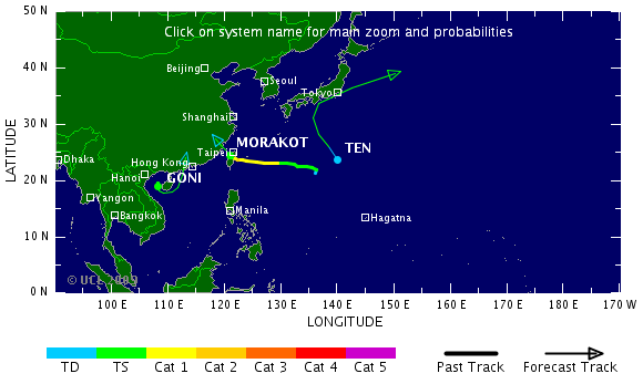
Morakot
Deze gaat nog flink wat ellende brengen in China.
Tropical Strom Felicia is inmiddels ook ontstaan, naast Enrique aan de Pacifische oostkust
Maar niet lang meer:quote:Op dinsdag 4 augustus 2009 17:03 schreef Frutsel het volgende:
[..]
IddMaar de Atlantische Oceaan blijft rustig


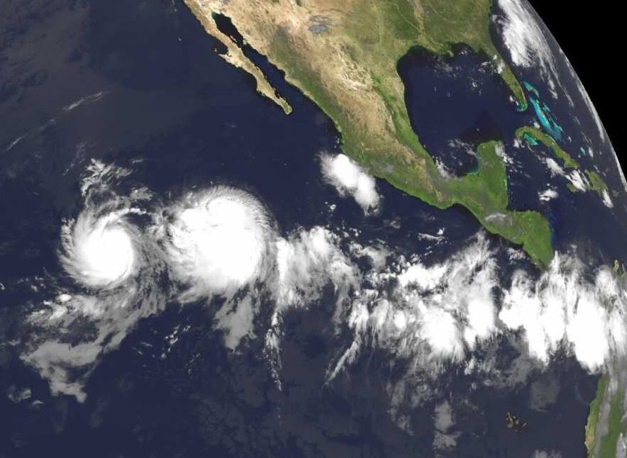
Eastern Pacific storms, monitoring Atlantic
There are two active systems in the eastern Pacific which are no threat to land.
Tropical storm Enrique with top sustained winds of 60 mph is located just over 730 miles southwest of Cabo San Lucas, Mexico. Enrique is forecast to strengthen some, but stay just below hurricane status as it moves to the west-northwest in the open Pacific.
Just to the west of Enrique, is Tropical Storm Felicia. Felicia is forecast to strengthen gradually and should become a hurricane over the next couple of days. The system is located around 1200 miles southwest of Cabo San Lucas, Mexico and is no threat to land.
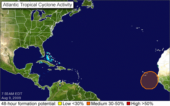
The Atlantic Basin remains quiet overall. However there is one area of interest well out in the eastern Atlantic.
An area of low pressure is located well southwest of the Cape Verde Islands between 30 and 40 west longitude. There continues to be some persistent convection and it will be monitored for slow development while moving off to the west.
So far we've had one tropical depression in May this season and no named storms.
In the Western Pacific, weak Tropical Storm Goni (50 mile per hour sustained winds) is forecast to move into the Mainland China Coast later today (Eastern time). Locally heavy rain appears to be the biggest threat from this cyclone.
Another tropical storm is located well east of Taiwan, named Morakot (50 mile per hour sustained winds). Although the track of this system is uncertain, it is expected to become a minimal typhoon on Wednesday (Eastern time) and head towards mainland China's Coast late in the week or over the weekend.
There are two active systems in the eastern Pacific which are no threat to land.
Tropical storm Enrique with top sustained winds of 60 mph is located just over 730 miles southwest of Cabo San Lucas, Mexico. Enrique is forecast to strengthen some, but stay just below hurricane status as it moves to the west-northwest in the open Pacific.
Just to the west of Enrique, is Tropical Storm Felicia. Felicia is forecast to strengthen gradually and should become a hurricane over the next couple of days. The system is located around 1200 miles southwest of Cabo San Lucas, Mexico and is no threat to land.
The Atlantic Basin remains quiet overall. However there is one area of interest well out in the eastern Atlantic.
An area of low pressure is located well southwest of the Cape Verde Islands between 30 and 40 west longitude. There continues to be some persistent convection and it will be monitored for slow development while moving off to the west.
So far we've had one tropical depression in May this season and no named storms.
In the Western Pacific, weak Tropical Storm Goni (50 mile per hour sustained winds) is forecast to move into the Mainland China Coast later today (Eastern time). Locally heavy rain appears to be the biggest threat from this cyclone.
Another tropical storm is located well east of Taiwan, named Morakot (50 mile per hour sustained winds). Although the track of this system is uncertain, it is expected to become a minimal typhoon on Wednesday (Eastern time) and head towards mainland China's Coast late in the week or over the weekend.

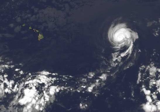
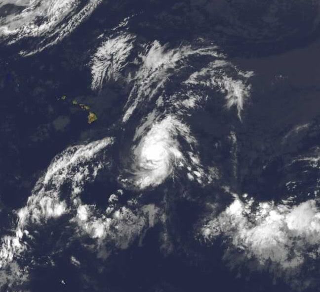
Felicia is inmiddels een caegorie 1 geworden (en wordt nog sterker) en gaat volgens de voorspelling richting Hawai.
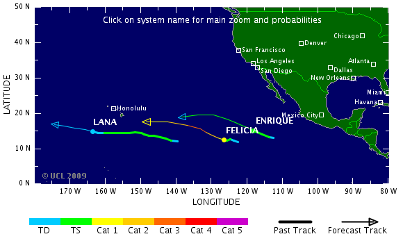
Felicia is de krachtigste storm van dit seizoen tot nu toe, volgens mij.
Althans, aan de US West/Eastcoast dan
Het Atlantische Basin komt ook in beweging...quote:DEEP TROPICAL CONVECTION ON THE INCREASE AS PATTERN READIES FOR DEVELOPMENT
Things are changing. The east Pacific is getting quite active and the reasons for it are coming east with time. Right now we have TS Enrique and TD 8-E in the waters well off the coast of Mexico- neither system poses an immediate threat to land. What it appears to indicate however, is that a more favorable pattern is migrating west to east and should be in the Atlantic Basin within the next few days. We are already seeing a very impressive tropical wave far out in the east Atlantic that has the NHC calling for a low chance of development. Some of the computer models pop in and out with latching on to this feature as it moves steadily west. Water temps are certainly warm enough but upper level conditions and even the moisture content of the atmosphere may limit development for a while longer. None the less, as we progress through the next week to 10 days, I expect that we will see a gradual increase in the chances of getting a named storm somewhere in the Atlantic Basin.
Met cat5 over Hawai heen straksquote:Op woensdag 5 augustus 2009 12:52 schreef Frutsel het volgende:
Felicia is de krachtigste storm van dit seizoen tot nu toe, volgens mij.
[..]
Die 2 gaan gewoon samen straks en vormen samen 1 mega orkaan die over hawai trektquote:Op woensdag 5 augustus 2009 20:33 schreef aloa het volgende:
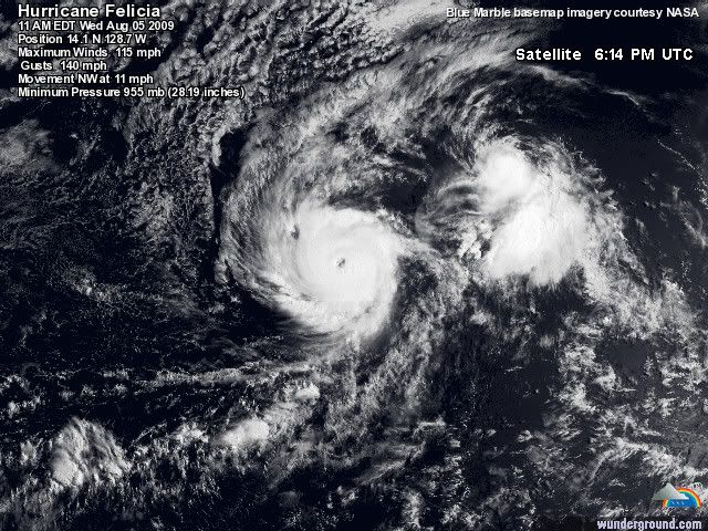
Felicia is al een cat 3 met een duidelijk oog.
[ afbeelding ]
Hmm..begin van de week leek Morakot gewoon een TS te worden, maar nu zelfs een Cat.3 Hurricane. Taiwan krijgt de volle laag

Morakotquote:NASA's Aqua satellite captured an infrared image that showed a huge cyclone named Morakot tracking through the East China Sea, on the way to a landfall in mainland China. Morakot is a large storm with maximum sustained winds near 69 mph (60 knots), just 5 mph shy of a category one hurricane strength. It's currently located in the East China Sea, near 23.2 north and 130.4 east. That's about 300 miles southeast of Okinawa, Japan. Its moving west near 14 mph. The Atmospheric Infrared Sounder is an instrument used in tropical storm research that flies on Aqua. AIRS provides visible, infrared and microwave images of tropical storms. AIRS also measures cloud top temperature and pressure and the profile of water vapor as functions of height. Infrared imagery shows the temperature of the cloud tops which gives a hint about the power of the thunderstorms in a tropical cyclone. The colder the clouds are, the higher they are, and the more powerful the thunderstorms are that make up the cyclone. Morakot will keep moving westward, and it will remain in warm sea surface temperatures and low wind shear over the next 72 hours, which will enable it to maintain its strength. Morakot's forecast track takes the center north of Taiwan and predicts a landfall almost directly between Hong Kong and Shanghai on August 6.

Hmzquote:Op donderdag 6 augustus 2009 11:03 schreef Frutsel het volgende:
[ afbeelding ]
Hmm..begin van de week leek Morakot gewoon een TS te worden, maar nu zelfs een Cat.3 Hurricane. Taiwan krijgt de volle laag
[ afbeelding ]
[..]
Morakot
[ afbeelding ]