WKN Weer, Klimaat en Natuurrampen
Lees alles over het onstuimige weer op onze planeet, volg orkanen en tornado's, zie hoe vulkanen uitbarsten en hoe Moeder Aarde beeft bij een aardbeving. Alles over de verwoestende kracht van onze planeet en tal van andere natuurverschijnselen.


quote:As far as the tropics go- we will end July without any issues what so ever. All is quiet and should remain that way for another week to perhaps 10 days. After the first week of August, I see a pattern change in the upper level wind flow that could allow for organized deep convection to begin flaring up in the Atlantic Basin. The tropical waves over Africa are strong and robust but the atmosphere over the eastern Atlantic has not been favorable to allow them to develop. There are signs in the longer range modeling that suggest this will change for a time beginning close to mid-August. For now, no problems exist in either the Atlantic or the east Pacific- so far so good.
quote:TROPICAL STORMS AND HURRICANES LIKELY TO BE SCARCE FOR A WHILE
From the looks of things, we will not see any tropical storms or hurricanes anytime soon. The pattern is still simply not conducive for any significant development. We are seeing quite a robust line of tropical waves emerge from the coast of Africa but hostile upper level winds and other factors are keeping them in check and not allowing them to grow and develop. I see nothing in the long range computer models to suggest a change anytime soon. After about August 10 or so, there may be a period of more favorable conditions but this remains to be seen

Hmmm er was toch een lage zeewatertemperatuur in de Atlantische oceaan ter hoogte van de evenaar toch?
Lage zeewatertemperatuur = minder kans op orkanen?
Lage zeewatertemperatuur = minder kans op orkanen?
Drugs are good mkay?
Meerdere oorzaken hebben d'r invoed op... maar dat is er idd één 
Maar je moet dan naar het water kijken vanaf de westkust van Afrika naar de Golf van Mexico, want daar zullen ze ontstaan. Daar is ook de wind van belang, bijv op de straalstroom enzo
Maar je moet dan naar het water kijken vanaf de westkust van Afrika naar de Golf van Mexico, want daar zullen ze ontstaan. Daar is ook de wind van belang, bijv op de straalstroom enzo
Iddquote:
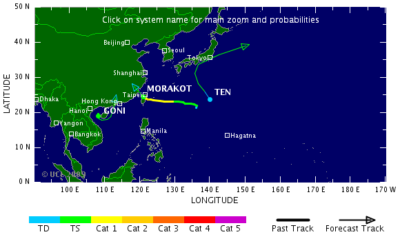
Morakot
Deze gaat nog flink wat ellende brengen in China.
Tropical Strom Felicia is inmiddels ook ontstaan, naast Enrique aan de Pacifische oostkust
Maar niet lang meer:quote:Op dinsdag 4 augustus 2009 17:03 schreef Frutsel het volgende:
[..]
IddMaar de Atlantische Oceaan blijft rustig


Eastern Pacific storms, monitoring Atlantic
There are two active systems in the eastern Pacific which are no threat to land.
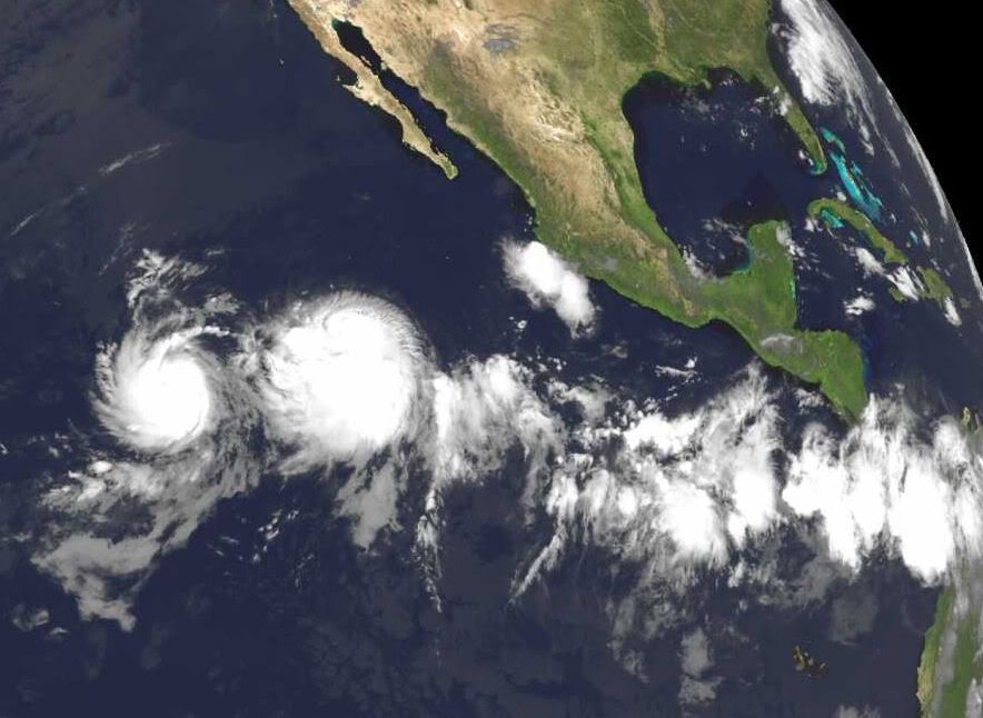
Tropical storm Enrique with top sustained winds of 60 mph is located just over 730 miles southwest of Cabo San Lucas, Mexico. Enrique is forecast to strengthen some, but stay just below hurricane status as it moves to the west-northwest in the open Pacific.
Just to the west of Enrique, is Tropical Storm Felicia. Felicia is forecast to strengthen gradually and should become a hurricane over the next couple of days. The system is located around 1200 miles southwest of Cabo San Lucas, Mexico and is no threat to land.
The Atlantic Basin remains quiet overall. However there is one area of interest well out in the eastern Atlantic.
An area of low pressure is located well southwest of the Cape Verde Islands between 30 and 40 west longitude. There continues to be some persistent convection and it will be monitored for slow development while moving off to the west.
So far we've had one tropical depression in May this season and no named storms.
In the Western Pacific, weak Tropical Storm Goni (50 mile per hour sustained winds) is forecast to move into the Mainland China Coast later today (Eastern time). Locally heavy rain appears to be the biggest threat from this cyclone.
Another tropical storm is located well east of Taiwan, named Morakot (50 mile per hour sustained winds). Although the track of this system is uncertain, it is expected to become a minimal typhoon on Wednesday (Eastern time) and head towards mainland China's Coast late in the week or over the weekend.
There are two active systems in the eastern Pacific which are no threat to land.
Tropical storm Enrique with top sustained winds of 60 mph is located just over 730 miles southwest of Cabo San Lucas, Mexico. Enrique is forecast to strengthen some, but stay just below hurricane status as it moves to the west-northwest in the open Pacific.
Just to the west of Enrique, is Tropical Storm Felicia. Felicia is forecast to strengthen gradually and should become a hurricane over the next couple of days. The system is located around 1200 miles southwest of Cabo San Lucas, Mexico and is no threat to land.
The Atlantic Basin remains quiet overall. However there is one area of interest well out in the eastern Atlantic.
An area of low pressure is located well southwest of the Cape Verde Islands between 30 and 40 west longitude. There continues to be some persistent convection and it will be monitored for slow development while moving off to the west.
So far we've had one tropical depression in May this season and no named storms.
In the Western Pacific, weak Tropical Storm Goni (50 mile per hour sustained winds) is forecast to move into the Mainland China Coast later today (Eastern time). Locally heavy rain appears to be the biggest threat from this cyclone.
Another tropical storm is located well east of Taiwan, named Morakot (50 mile per hour sustained winds). Although the track of this system is uncertain, it is expected to become a minimal typhoon on Wednesday (Eastern time) and head towards mainland China's Coast late in the week or over the weekend.

Felicia is inmiddels een caegorie 1 geworden (en wordt nog sterker) en gaat volgens de voorspelling richting Hawai.
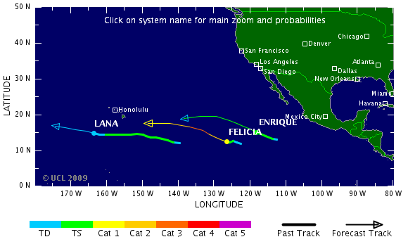
Felicia is de krachtigste storm van dit seizoen tot nu toe, volgens mij.
Althans, aan de US West/Eastcoast dan
Het Atlantische Basin komt ook in beweging...quote:DEEP TROPICAL CONVECTION ON THE INCREASE AS PATTERN READIES FOR DEVELOPMENT
Things are changing. The east Pacific is getting quite active and the reasons for it are coming east with time. Right now we have TS Enrique and TD 8-E in the waters well off the coast of Mexico- neither system poses an immediate threat to land. What it appears to indicate however, is that a more favorable pattern is migrating west to east and should be in the Atlantic Basin within the next few days. We are already seeing a very impressive tropical wave far out in the east Atlantic that has the NHC calling for a low chance of development. Some of the computer models pop in and out with latching on to this feature as it moves steadily west. Water temps are certainly warm enough but upper level conditions and even the moisture content of the atmosphere may limit development for a while longer. None the less, as we progress through the next week to 10 days, I expect that we will see a gradual increase in the chances of getting a named storm somewhere in the Atlantic Basin.
Met cat5 over Hawai heen straksquote:Op woensdag 5 augustus 2009 12:52 schreef Frutsel het volgende:
Felicia is de krachtigste storm van dit seizoen tot nu toe, volgens mij.
[..]
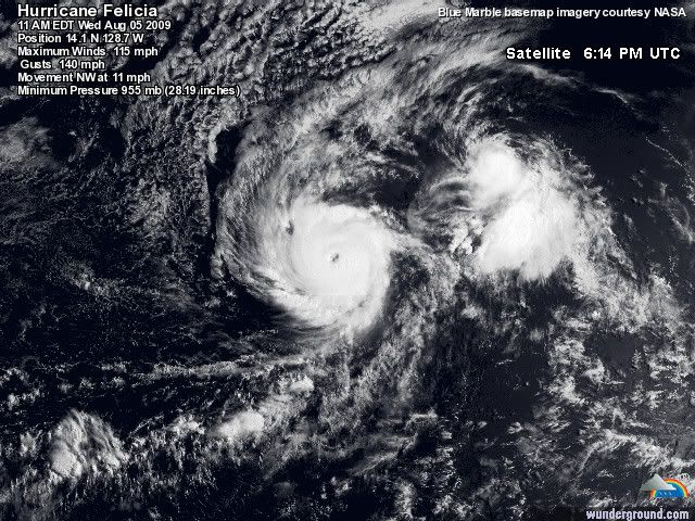
Die 2 gaan gewoon samen straks en vormen samen 1 mega orkaan die over hawai trektquote:Op woensdag 5 augustus 2009 20:33 schreef aloa het volgende:
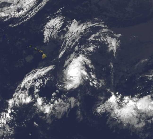
Felicia is al een cat 3 met een duidelijk oog.
[ afbeelding ]
Hmm..begin van de week leek Morakot gewoon een TS te worden, maar nu zelfs een Cat.3 Hurricane. Taiwan krijgt de volle laag

Morakotquote:NASA's Aqua satellite captured an infrared image that showed a huge cyclone named Morakot tracking through the East China Sea, on the way to a landfall in mainland China. Morakot is a large storm with maximum sustained winds near 69 mph (60 knots), just 5 mph shy of a category one hurricane strength. It's currently located in the East China Sea, near 23.2 north and 130.4 east. That's about 300 miles southeast of Okinawa, Japan. Its moving west near 14 mph. The Atmospheric Infrared Sounder is an instrument used in tropical storm research that flies on Aqua. AIRS provides visible, infrared and microwave images of tropical storms. AIRS also measures cloud top temperature and pressure and the profile of water vapor as functions of height. Infrared imagery shows the temperature of the cloud tops which gives a hint about the power of the thunderstorms in a tropical cyclone. The colder the clouds are, the higher they are, and the more powerful the thunderstorms are that make up the cyclone. Morakot will keep moving westward, and it will remain in warm sea surface temperatures and low wind shear over the next 72 hours, which will enable it to maintain its strength. Morakot's forecast track takes the center north of Taiwan and predicts a landfall almost directly between Hong Kong and Shanghai on August 6.

Hmzquote:Op donderdag 6 augustus 2009 11:03 schreef Frutsel het volgende:
[ afbeelding ]
Hmm..begin van de week leek Morakot gewoon een TS te worden, maar nu zelfs een Cat.3 Hurricane. Taiwan krijgt de volle laag
[ afbeelding ]
[..]
Morakot
[ afbeelding ]
Ziet er naar uit dat dat de eerste wordt iddquote:A VERY ACTIVE PATTERN APPEARS LIKELY AS WE GET DEEPER IN TO AUGUST
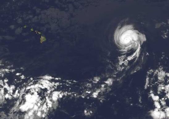
Even though it has been a very quiet hurricane season for the Atlantic, things are about to change and in a hurry. First up however, is TS Felicia in the Pacific. The good news, and it really is considering how strong Felicia was recently, is that the storm is on its way down in terms of overall impacts to Hawaii. The latest forecast track from the CPHC shows Felicia passing to the north of the Big Island with the storm quickly fading while it does so. Effects should be quite minimal with the exception of increased seas along the north facing beaches. Not sure if they are filming LOST out there now or not (huge fan here), but it could make for some incredible sunsets coming up. Other than that, Hawaii will not sustain any serious negative impacts from Felicia.
In the Atlantic, the pattern change to a more favorable environment seems to be well on its way. We have what looks to be a developing depression way out near the Cape Verde Islands and even more energy lining up over Africa. These next two weeks or so could very well be the most active part of the hurricane season if forecasts for a hostile peak in September hold true. The long range computer models are latching on and developing multiple systems over the next several days. This is all very much expected and is by no means a surpise- even in the face of such a slow start to the season. There is absolutely nothing to be alarmed about right now. The season is coming to life and people all along the coastal areas of the U.S. and adjacent land masses should simply pay attention and be ready to act if one of these potential developments poses a problem down the road. It's all about being aware. We are very busy these days and life moves fast. The tropics can change just as fast but still give us plenty of warning. So far, we are looking really good this season- the hope is that it continues. But hope alone will not prepare people for what may lie ahead.
bronquote:Tientallen doden door tyfoons in Oost-Azië
In het Verre Oosten zijn zeker 42 mensen omgekomen toen de regio werd getroffen door tyfoons. Dat meldden de autoriteiten in de verschillende landen maandag. Tientallen mensen worden nog vermist.
De meeste doden vielen op Taiwan. Daar verloren door tyfoon Morakot zeker 23 mensen het leven, terwijl nog 56 mensen worden vermist. In het weekeinde viel op het eiland een recordhoeveelheid regen (250 centimeter).
Het weg- en treinverkeer ondervinden grote hinder van overstromingen en aardverschuivingen. Op veel plaatsen is de elektriciteit uitgevallen.
Tropische storm
In China is Morakot afgezwakt tot een tropische storm. Er kwamen hier minstens zes mensen om. De autoriteiten hadden in de kustprovincies uit voorzorg meer dan een miljoen mensen geëvacueerd.
In Japan zijn zeker dertien mensen omgekomen door overstromingen en aardverschuivingen, die zijn veroorzaakt door de nadering van de tyfoon Etau. Achttien mensen worden vermist. De hevige wervelstorm zal vermoedelijk dinsdag op volle kracht over Japan trekken. Er zijn 50.000 mensen geëvacueerd.
quote:UPDATED: 8:10 pm EDT, August 10, 2009
I do not have much in the way of new information tonight since nothing dramatic has really taken place since this morning. In the Pacific, Felicia is still winding down and should pass through Hawaii without much fanfare. In fact, the storm is basically just a swirl of low clouds with sparse convection at best.
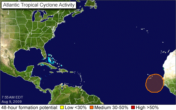
In the Atlantic, we'll be watching 99L way out near the Cape Verde Islands for slow development. It could take a while and of course, there is no guarantee it will ever really get cranking. However, its energy will remain in tact even though it may not become a tropical cylcone right away. We must always watch these kinds of features as the progresses steadily westward. Elsewhere, tropical waves at around 47 west and 62 west also bear close monitoring as they too try and organize slowly. The pattern is becoming more and more favorable for us to see perhaps several named storms over the coming two to three weeks. Nothing out there just yet but it's getting close.

wat ben je dan laat met je tvpquote:
TVP.... Blijft een boeiende topicreeks dit
Hoewel er nu wel 4 systemen in wording zijn, ben benieuwd of daar ook een orkaan uitkomt. Maar tot nog toe hebben ze het gelukkig rustig.
Eastern Pacific heeft aardig wat voor de kiezen gehad hoor, alleen niet aan land 
BTW: Heel 'DE' als subforum blijft boeiendquote:
TVP.... Blijft een boeiende topicreeks dit
Hmm... hij maakt zich duidelijk zorgen over het systeem dat zich nu nog aan het ontwikkelen is dus. En dat elke 'run' die hij uitvoert er uit ziet dat er een flinke orkaan kan ontstaan en dat vooral mensen in de "Lesser Antilles" de komende tien tot veertien dagen hun ogen open moeten houden.quote:UPDATED: 9:15 am EDT, August 12, 2009
TROPICS GOING TO BE BIG NEWS OVER THE NEXT WEEK TO 10 DAYS
It is time to pay closer attention to the Atlantic Basin and its growing areas of concern. I say concern because it is time to take notice of what is going on out there and be prepared for it. I am not talking about just the United States either- remember, we have quite a few land masses out there in the Basin. Here's what we have...
TD2 should become a tropical storm later today if it is not one already. It is not of much concern right now and should avoid the Lesser Antilles as it moves west over the next five days. Beyond that time period, we will just have to see if it survives a trip through some stronger upper level winds before worrying where it ends up. There's plenty of time to monitor its progress and thus far, it looks to remain fairly weak.
The other developing story will be a new tropical cyclone taking shape right now off the coast of Africa. The GFS computer model in particular has been remarkably consistent with its forecast of a long-track system in the Atlantic. The tropical wave that would be "the one" is now off the coast of western Africa and is already looking better organized as each hour passes. It should become a tropical depression within the next two days and rapidly strengthen beyond that. My first concern is for the Lesser Antilles. From the looks of the steering patterns, an almost due-west track seems likely for this system once it gets going. This would put it in the vicinity of the Windwards and Leewards in about a week- maybe less. I figured people would want as much notice as possible just in case the computer modeling is even close to spot on. Run after run after run of the GFS shows this system plowing through the eastern Caribbean. Perhaps the model will be wrong, but it did a similar job of accurately forecasting the genesis and track of powerful hurricane Dean in 2007. So if you live in or are planning a trip to the Lesser Antilles and surrounding region, pay close attention to the tropics from now on. We have the luxury of seeing the possible future with computer guidance and related technology, there should be no suprises in this day and age.
Lastly, a tropical wave crossing the Antilles now should continue generally WNW and in to the Gulf of Mexico early next week. We'll see if it blossoms and develops more. This is where model guidance is tough because some show development, others do not. It is a feature to watch until it interacts with land and dies away. Its passage through the Caribbean will bring sporadic showers and thunderstorms but otherwise not much more than that.

Ben benieuwd wat er met dat ding op de atlantische oceaan gaat gebeuren. En voor de kust van West-Afrika nog een mooi frontje.
's Avonds een man, overdags rustig an
Lesser Antilles.. Ik zit op Curacao dus ik ga zeker mijn ogen open houden.
Ik zit bij de landmacht en ze gingen er vanuit dat er geen orkaan zou komen, maar mocht er eentje komen dan moeten wij hulp gaan bieden..
Mogen ze ons snel even alvast gaan voorbereiden voor de zekerheid..
Ik zit bij de landmacht en ze gingen er vanuit dat er geen orkaan zou komen, maar mocht er eentje komen dan moeten wij hulp gaan bieden..
Mogen ze ons snel even alvast gaan voorbereiden voor de zekerheid..
Volgende week woensdag zit die bij domicaanse republiek/cuba als het zo doorgaat....laat ik nou net volgende week woensdag een tussenlanding hebben op cuba, hahaquote:
Drugs are good mkay?
Denk dat TD 2 niet zover komt... d'r komt er nog eentje achteraan die eind volgende week problemen kan gaan geven.quote:
[..]
Volgende week woensdag zit die bij domicaanse republiek/cuba als het zo doorgaat....laat ik nou net volgende week woensdag een tussenlanding hebben op cuba, haha
Nja hij kan aan kracht winnenquote:Op donderdag 13 augustus 2009 14:27 schreef Frutsel het volgende:
[..]
Denk dat TD 2 niet zover komt... d'r komt er nog eentje achteraan die eind volgende week problemen kan gaan geven.
Drugs are good mkay?
Inmiddels heeft het NHC Tropical Despression 2 gedeclasseerd en is dus van de kaart verdwenen als 'Tropisch' ... Helaasch dus... maar zoals ik zei.. het gebied daar achter, dat wordt interessant om te volgen, dat wordt de eerste 'naam-storm' van het seizoenquote:
Boven hispaniola ligt ook nog een lekker gebied wat een kleine kans heeft om uit te groeien tot meer. Dan helpt die temperatuur in elk geval welquote:
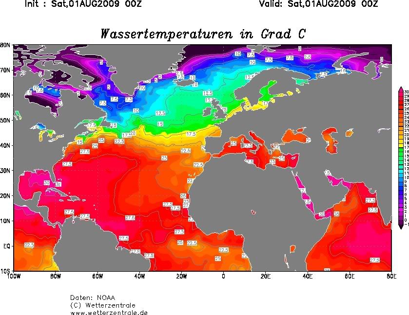
De golf van Mexico is al aardig opgewarmd naar een dikke 30-32 graden
Guillermo is inmiddels een orkaan