WKN Weer, Klimaat en Natuurrampen
Lees alles over het onstuimige weer op onze planeet, volg orkanen en tornado's, zie hoe vulkanen uitbarsten en hoe Moeder Aarde beeft bij een aardbeving. Alles over de verwoestende kracht van onze planeet en tal van andere natuurverschijnselen.


Krijgen we nu al de eerste tropische storm in de Golfregio?
Het 'officiële seizoen' begint pas op 1 juni


NOAA: verwacht een normaal hurricane seizoen
OAA (National Oceanic and atmospheric Administration) verwacht een orkaanseizoen die voldoet aan het klimatologisch gemiddelde.
De laatste jaren was het orkaanseizoen vrij actief met als meest opvallende jaar 2005 toen een groot aantal hurricanes het levenslicht zagen. De meeste bekendheid kreeg
hurricane Katrine die enorme schade aanrichte in New - Orleans. NOAA gaat uit van 14 tropische stormen waarvan een aantal uit zullen groeien tot een hurricane. Voorlopig
gaat men er van uit dat er 1 a 3 mayor hurricanes zullen ontstaan. Dit zijn Orkanen die vallen in de categorie 3 of meer op een schaal van 5. Het seizoen start op 1 juni. Dat het seizoen iets minder actief zal zijn wordt o.a. veroorzaakt door de mogelijk opkomst van een El Nino.
vwk
quote:Aila moves towards coast
The cyclonic storm 'Aila' over north Bay and adjoining west central Bay moved northwards over the same area.
The storm is likely to intensify further and move in a northerly direction and cross West Bengal-Khulna coast by afternoon or evening.
It was centred at 9am on Monday about 435 km southwest of Chittagong port, 405 km southwest of Cox's Bazaar port and 285 km southsouthwest of Mongla port, said a special weather bulletin issued Monday morning said.
Maximum sustained wind speed within 54 km of the storm centre is about 70 kph rising to 90 kph in gusts or squalls. Sea will remain very rough, the bulletin said.
Maritime port of Mongla has been advised to keep hoisted danger signal number seven.
The coastal districts of Bhola, Barisal, Patuakhali, Barguna, Pirozpur, Jhalokathhi, Bagerhat, Khulna, Satkhira, Jessore and their offshore islands and chars will be under danger signal number seven.
Maritime ports of Chittagong and Cox's Bazaar have been advised to keep hoisted danger signal number six.
The coastal districts of Cox's Bazaar, Chittagong, Noakhali, Feni, laxmipur, Comilla, Chandpur and their offshore islands and chars will be under danger signal number six.
Under the influence of the storm, the coastal districts of Khulna, Bagerhat, Borguna, Satkhira, Barisal, Patuakhali, Bhola, pirozpur, Jhalokathhi, Laxmipur, Noakhali, Feni, Chandpur, Chittagong, Cox's Bazaar and their offshore islands and chars are likely to experience heavy to very heavy rain accompanied by squally winds of speed up to 90 kph with the passage of the storm.
The low-lying areas of the coastal districts of Khulna, Bagerhat, Borguna, Satkhira, Barisal, Patuakhali, Bhola, Pirozpur, Jhalokathhi, Laxmipur, Noakhali, Feni, Chandpur, Chittagong, Cox's Bazaar and their offshore islands and chars are likely to be inundated by storm surge of height of six to eight feet above normal astronomical tide.
All fishing boats and trawlers over north Bay have been advised to remain in shelter till further notice.
River traffic halted
The weather has forced suspension of ferry movement since 8am Sunday on all rivers routes, Patuakhali river port official Md Shahidul Mia said.
Fishermen are coming back from the sea because of high tide, said general secretary of fish traders committee Nimai Chandra from Kuakata.
The rivers in the costal areas are flowing in high tide because of the depression in the bay, said Ahsan Azim from Charkajal.
It had been raining sporadically in the coastal areas of Patuakhali since Saturday midnight, our correspondent said.
Barguna wary
The people of the coastal southern district of Barguna, hit by cyclone Sidr in late 2007, are living in constant fear on the news that a depression in the Bay of Bengal has deepened and still intensifying.
Our correspondent says it has been raining sporadically since Saturday midnight and the sun has remained behind the clouds.
Hundreds of fishing trawlers have returned to Pathorghata, Noli and Taltoli from the Bay until Sunday afternoon, said president of Barguna District Trawler Owners' Association Golam Mostafa Chowdhury.
"We will start calling people to shelter buildings through megaphones as soon as the level of the signal is increased," said the team leader of cyclone preparation activities and member of Borguna Red Crescent Unit Zakir Hossain Miraj.
Filmpje RTL: Ravage na Cycloon Aila in Bangladesh en Indiaquote:Aila maakt zeker 28 doden in India en Bangladesh
Na de doortocht van de cycloon Aila zijn in het oosten van India en buurland Bangladesh zeker 28 doden geteld. In de miljoenenmetropool Calcutta (Kolkata) alsook in andere delen van de deelstaat West-Bengalen lieten 19 mensen het leven. In Bangladesh kwamen negen mensen om het leven. Er zijn nog tientallen vermisten.
De cycloon kwam met windsnelheden tot 120 kilometer per uur aan land en zorgde voor aanzienlijke schade. Alleen in India werden zo'n 110.000 mensen uit hun huizen verdreven. Het leven in Calcutta viel maandag stil. De autoriteiten hadden de kustbewoners 's morgens voor de cycloon gewaarschuwd. De tropische storm vormde zich boven de Golf van Bengalen. In Bangladesh ligt de passage van cycloon Sidr in november 2007 nog vers in het geheugen: die eiste toen aan ongeveer 4.000 mensen het leven, tienduizenden personen raakten dakloos. (BEH)
http://www.rtl.nl/compone(...)22/Tue11.cycloon.xml
Cycloon Aila eist ruim 70 levens in India en Bangladesh
Eigen topic gegeven
[ Bericht 37% gewijzigd door Frutsel op 26-05-2009 12:23:05 ]

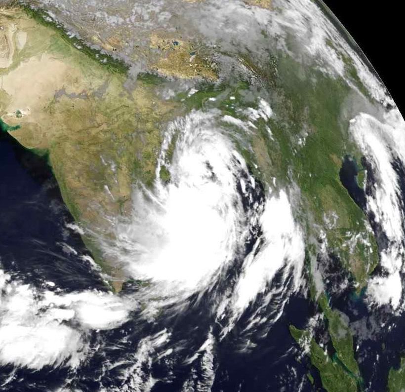
Tropical Storm Aila struck southern Bangladesh and eastern India on May 27, 2009. The New York Times reported that floods and mudslides killed at least 191 people and left hundreds of thousands more homeless. As of May 27, the death toll was expected to rise.
The Moderate Resolution Imaging Spectroradiometer (MODIS) on NASA’s Terra satellite captured this true-color image of Aila on May 25, 2009, the same day that the storm temporarily strengthened to a Category 1 cyclone. Aila almost completely fills this scene, stretching from the Bay of Bengal deep into India, Bangladesh, and Burma (Myanmar). On May 25, Aila’s wind speeds ranged from 74 kilometers per hour (46 miles per hour or 40 knots) to 120 kilometers per hour (75 miles per hour or 65 knots).
According to the Associated Press, some 2.3 million people were affected by Aila, many of them stranded in flooded villages. Storm surges in Bangladesh flooded agricultural areas with salty water. Home to roughly 25,000 residents, the coastal island Nijhum Dwip was reported to be completely submerged. As of May 27, 2009, many rural villages had not yet been reached by relief workers, and the death toll was expected to rise significantly as search and rescue efforts continued.
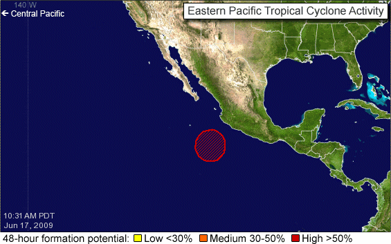
Rustig begin van het seizoen... ik las ergens dat 19 juni het record is dat op zijn laatst op de Oost Pacific zich een storm ontwikkelde. Dat lijken we net niet te gaan halen
In het Atlantische basin verwachten we pas eind juni de eerste ontwikkelingen, aldus lange termijn modellen
In het Atlantische basin verwachten we pas eind juni de eerste ontwikkelingen, aldus lange termijn modellen
Hopelijk een rustig seizoen dit jaarquote:Op woensdag 17 juni 2009 09:12 schreef Frutsel het volgende:
Rustig begin van het seizoen... ik las ergens dat 19 juni het record is dat op zijn laatst op de Oost Pacific zich een storm ontwikkelde. Dat lijken we net niet te gaan halen
[ afbeelding ]
In het Atlantische basin verwachten we pas eind juni de eerste ontwikkelingen, aldus lange termijn modellen


http://www.usatoday.com/w(...)rricane-season_N.htm
quote:Hurricane season off to a typically slow start
The first month of the Atlantic hurricane season ended with a whimper Tuesday: No named tropical storms or hurricanes formed in June.
However, that's not unusual, as the average date of the first named storm doesn't occur until July 10, according to Dennis Feltgen, a meteorologist at the National Hurricane Center in Miami. Feltgen also reports that the average date of the first Atlantic hurricane is Aug. 14.
Since the naming of storms began in 1953, the latest an Atlantic storm has formed was Anita on Aug. 29, 1977. On average, based on records that go back to 1851, a tropical storm forms every other June in the Atlantic basin, which also encompasses the Gulf of Mexico and the Caribbean Sea.
The National Oceanographic and Atmospheric Administration predicted in May that there would be nine to 14 named storms in the Atlantic this year, of which four to seven could become hurricanes, including one to three major hurricanes (Category 3, 4 or 5).
A quiet June doesn't necessarily presage a quiet remainder to the season, reminds Feltgen. In 2004, a year that had 15 named storms — including Charley, Frances, Ivan and Jeanne — the first storm didn't form until July 31.
In the eastern Pacific basin, Hurricane Andres was the only named storm to form in June. It grazed the west coast of Mexico on June 22, killing one person.
No storms or hurricanes are forecast to form in either the Atlantic or Pacific basins for at least the next two days, reports the center.
Het is inderdaad rustig, maar er kunnen nog genoeg orkanen ontstaan in de Atlantische Oceaan.quote:A quiet June doesn't necessarily presage a quiet remainder to the season, reminds Feltgen. In 2004, a year that had 15 named storms — including Charley, Frances, Ivan and Jeanne — the first storm didn't form until July 31.
Het blijft rustig
quote:Tropical Atlantic and Pacific quiet
In the Atlantic basin, a tropical wave that passed through the southern Antilles yesterday may help to enhance some showers and thunderstorms the the western Caribbean Sea today and tomorrow.
Another tropical wave currently crossing the central tropical Atlantic will reach the Antilles by this weekend bringing showers there.
None of these areas are expected to show any tropical organization, and no tropical development is expected over the next few days.
Meanwhile, a flow of tropical moisture over central and southern Florida will bring more downpours today into Friday, but should taper a bit this weekend. The typical afternoon chance of showers and thunderstorms will continue however.
In the eastern Pacific basin, no tropical development is expected in the near term.

Hurricanetrack praat voornamelijk over de Pacific, geeft Atlantisch weinig kansquote:UPDATED: 12:50 pm EDT, July 1, 2009
MAJOR OUTBREAK OF DRY, STABLE AIR IN EAST ATLANTIC AS EAST PACIFIC IS ABOUT TO POP
SAL is back. In this case, the Saharan Air Layer. It is a blast of warm, dusty and very stable air that comes off of Africa and extends out in to the Atlantic. Check out the link below from the CMISS site. It shows very clearly the strong SAL outbreak. You can track its progress over the coming days as the air mass migrates westward. What does it mean for tropical development? A solid cap placed on convection in the east Atlantic- at least for now. While there is a forecast for less than average dust outbreaks over the Atlantic, we can expect to see bursts like the one today. It is fascinating to see and modern satellite technology allows easy tracking of these large scale features.
The Atlantic Basin is and will be very quiet for many days to come. No worries at all for coastal areas for this coming big weekend.
In the east Pacific, all is quiet for now but it appears that several areas of development may pop up in the coming days. The ECMWF model in particular is showing a string of storms developing in about 3 to 10 days. The good news is that it would appear that these potential developments would be far off the coast of Mexico and moving generally away from land. It is amazing to see computer model forecasts for something that is not there now, but very well could be several days out. We'll see. The east Pacific is primed for development right now so it would make sense at least.
Het is een saaie boel de laaste weken als het gaat om tropische stormen. 
mischien stilte voor de storm?
mischien stilte voor de storm?

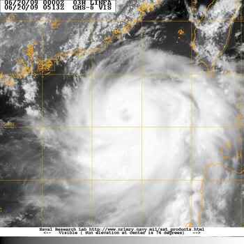
quote:BreakingNews BULLETIN -- TROPICAL STORM CARLOS STRENGTHENS INTO A CATEGORY ONE HURRICANE OFF MEXICO. less than a minute ago
Carlos gaat nog sterker worden ook.
Misschien dat Hawai er nog wat van mee gaat krijgen.
[ Bericht 1% gewijzigd door #ANONIEM op 12-07-2009 21:21:54 ]
Misschien dat Hawai er nog wat van mee gaat krijgen.
[ Bericht 1% gewijzigd door #ANONIEM op 12-07-2009 21:21:54 ]
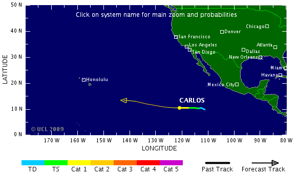
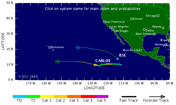
quote:Carlos stronger; new depression forms
Carlos became the 2nd eastern Pacific hurricane of the 2009 season for roughly a day this past weekend. The tropical cyclone weakened later Sunday into early Monday into a tropical storm.
Early Tuesday morning, an eye feature began to appear and Carlos became a hurricane once again.
Maximum sustained winds are up to 105 miles per hour in a very small area near the center of circulation. Carlos is a tiny hurricane, with tropical storm force winds only extending about 45 miles from the center.
Carlos about 1525 miles west-southwest of Cabo San Lucas, Mexico remains only a threat to marine interests and is expected to remain that way over the next 5 days.
The hurricane is moving to the west near 6 miles per hour, and a general west or west-northwest motion is expected to continue. This westbound track may bring Carlos in shearing winds in a few days that could quickly weaken the tropical cyclone.
A much larger circulation closer to the Mexican West Coast (but far enough away not to be a threat to land) has become Tropical Depression 5-E as of Tuesday evening.
The depression is located about 680 miles south-southwest of Cabo San Lucas, Mexico, with maximum sustained winds near 35 miles per hour. The depression could become a tropical storm sometime on Wednesday. If it does so, it would be called Dolores.
The depression is moving west-northwest around 10 miles per hour, with a general west-northwest motion expected over the next few days.
The Atlantic Basin remains quiet.
wie weetquote:UPDATED: 10:15 am EDT, July 17, 2009
TROPICAL WAVES IN ATLANTIC GETTING A LITTLE MORE ACTIVE
We are about a month away from the real meat of the hurricane season getting started. Signs of that are starting to appear as we see the tropical waves in the eastern Atlantic beginning to get a little stronger. One such wave is being "outlooked" by the NHC as having a low chance of development. It has by far the most impressive look to it of the season but has a long way to go before it would develop fully. Conditions are still quite hostile across much of the deep tropics and the Caribbean Sea. None the less, we'll obviously monitor it as it tracks steadily westward over the next week to 10 days. It won't go away, the energy will remain even if it does not develop right away. Where that energy ends up is important. The farther west these things make it before blossoming, then the closer they are to land areas.

quote:Two Atlantic waves
The tropics are quiet around the globe once again now that what's left of Molave is raining itself out over southern China and northern Vietnam.
In the eastern Caribbean, the tropical wave that brought heavy storms to the islands has been sheared apart. The showers have diminished and the tropical wave is now barely discernible in the wind flow.
The second wave, 700 miles east of the Windward Islands, remains disorganized as it heads westward. It will bring more rain to parts of the Lesser Antilles early week.
quote:Typhoon Molave weakens to tropical depression, bringing heavy rain to south China
GUANGZHOU, July 19 (Xinhua) -- Typhoon Molave weakened into a tropical depression Sunday afternoon after it landed in south China's Guangdong Province early Sunday and then entered neighboring Guangxi.
The storm made landfall in Nan'ao Town in Shenzhen City at 12:50 a.m. with winds of up to 145 km per hour at its center.
From 8 a.m. to 2 p.m. Sunday, downpours drenched Zhanjiang, Maoming, Jiangmen and Yangjiang in Guangdong, with 13 hydrological stations reporting precipitation of more than 100 mm, the Guangdong Hydrological Bureau said.
As of 5 p.m., no casualties were reported in Guangdong.
Maritime rescuers successfully pulled a stranded vessel off Shantou, Guangdong, to Haimen Port of Shantou amid high winds and saved seven crew members on it at 9:30 a.m. Sunday.
The storm left Guangdong and entered Guangxi Zhuang Autonomous Region at 1:40 p.m. and downgraded into a tropical depression at 3p.m. in Wuzhou City.
The National Meteorological Center forecast Sunday afternoon rainstorms would sweep parts of Guangdong, Guangxi, Yunnan and Guizhou Sunday night to Monday.

Vooralsnog niets dusquote:Even though we are seeing a more active pattern with the emergence of stronger tropical waves in the Atlantic, thee is still no reason to be concerned that any of them will develop. The main reason is hostile upper level winds. While we are seeing a flare up of convection with the tropical wave about to move through the Windward Islands, and this will certainly bring its share of squally weather to the region, upper level winds will not allow for much more organization. This is fairly typical of this time of the year as we are still several weeks away from the start to the rapid ramp up in expected activity.
Another area to at least monitor over the coming days is a large and complex weather pattern well off the Southeast coast. It is a combination of mid to upper level energy interacting with a tropical wave and its heat and energy. All of this spells plenty of convection over the southwest Atlantic but nothing seems to be consolidating in to a surface low pressure. If you're heading to the Bahamas, depending on where you are, there is a chance of off and on showers and thunderstorms as this mess of weather persists over the week ahead. It should all lift out by the weekend.
Eerste 'naam-storm' wordt straks pas augustus ofzo

quote:Though Typhoon Molave was still a tropical storm when it moved across the northern tip of Luzon, the largest of the Philippine Islands, on July 17 and July 18, 2009, its drenching rains caused widespread flooding. By July 20, the clouds had cleared enough to give the Moderate Resolution Imaging Spectroradiometer (MODIS) on NASA’s Terra satellite this view of the flooded island. The lower image, from July 15, 2009, shows the Cagayan River system in northern Luzon before the storm came ashore.
Both images contain a mixture of infrared light and visible light to increase the contrast between water and land. In this type of image, water is black. Sediment-laden water tends to be dark blue. The lush, plant-covered land of the tropical island is bright green, while clouds are pale blue and white.
In the wake of the storm, dark pools of water mark the land along the length of the Cagayan River and its tributaries. The flooding is most pronounced near the shore. Another sign of flooding is the plume of sediment that flows from the mouth of the Cagayan River. Floods sweep soil off the land and carry it into rivers and the ocean. The river plume contains more sediment than it had on July 15.
According to the AFP news service, Typhoon Molave caused at least three deaths in the Philippines. Much of the damage came from widespread flooding throughout Luzon. About 95,000 people were evacuated from their homes outside Manila in southern Luzon as a result of flooding, reported the AFP news.


quote:On July 17, 2009, when NASA’s QuikSCAT satellite captured the data used to make this image, Tropical Storm Molave hung over the northern Philippines, drenching the islands with heavy rain and causing widespread flooding. The image shows the structure of winds within the strengthening storm. Purple and red depict the highest wind speeds, while blues and greens point to calmer winds. Barbs indicate the direction of the wind, and white barbs indicate areas of heavy rain. The calm eye of the storm is a circle of blue surrounded by yellow and red. The strongest winds are close to the center on the east side of the storm.
QuikSCAT measures wind speeds over the ocean by sending pulses of microwave energy through the atmosphere to the ocean and measuring the energy that bounces back from the wind-roughened surface. The energy of the microwave pulses changes depending on wind speed and direction, giving scientists a way to monitor wind around the world. About the time that QuikSCAT acquired this image of Tropical Storm Molave over the Philippines, the Joint Typhoon Warning Center estimated the storm’s maximum sustained winds to be about 110 kilometers per hour (70 miles per hour or 60 knots).
quote:A new tropical disturbance has formed north of the central Bahama Islands, about 600 miles east of Miami. The thunderstorm activity is not yet very intense, but does cover a moderately large area. This morning's QuikSCAT pass showed winds of 20 - 25 mph, and no evidence of a circulation trying to form. This region is under about 20 - 25 knots of wind shear, and has the potential for some slow development over the next few days as it moves slowly northwards. The GFS and ECMWF models hint at the possibility that this system may attempt to organize into a tropical depression by Friday, off the coast of North Carolina.
quote:UPDATED: 8:30 am EDT, July 22, 2009
COMPUTER MODELS POINTING TOWARDS LOW PRESSURE AREA DEVELOPING OFF SOUTHEAST COAST SOON
As I mentioned in yesterday's evening post, I am increasingly confident that we will see a low pressure area form somewhere off the Southeast coast- probably later tomorrow. It is originating from what has been a somewhat complex weather pattern over the SW Atlantic. Arriving on the scene shortly is a tropical wave that will add energy to the system. Several of the global computer models indicate that a surface low will form and strengthen as it moves roughly parallel to the East Coast. It appears that it will be far enough off shore to keep the weather from being too adversely affected but boating interests should be aware of this developing situation. The NHC is showing a low chance of development as of now but I believe this will go up later today. If the low is tropical in nature, with a warm core and defined banding features, it could very well get a name- our first of the season. We'll have watch as this system evolves but it does not look to be a significant threat to land- more just an interesting feature to track. I'll post an update later this afternoon.
Die in de Golfregio/Caraiben wordt dus niets. Misschien dan voor de oostkust?
quote:NON-TROPICAL STORM LASHING NEW ENGLAND TONIGHT
Thought I would post a quick update on the non-tropical storm that is affecting a good deal of New England tonight. Checking the latest wind readings- I see wind gusting to 31mph in Montauk with an air pressure reading of 1009 mb. Elsewhere, in Bridgeport, CT, heavy rain is falling with winds steady at 20-25 mph out of the northeast. This is all due to a potent storm that has some of its energy derived from the tropical wave that emerged from Africa many days ago. This wave became quite active in the central Atlantic and looked like it might develop enough to become a tropical cyclone. It did not quite make it but the resulting ocean storm is packing quite a punch for late July! I was in this very region last September tracking hurricane Kyle and believe me, this will be quite a different story than Kyle- or any event of this nature in many years. The storm should pass quickly in to Canada tomorrow but not before dumping very heavy rains and bringing gusty winds and coastal flooding to the remainder of New England
Nog steeds rustig in de Atlantische Oceaan
quote:The Atlantic basin remains quiet.
Three tropical waves are spaced out from the western Caribbean to the far eastern Atlantic. Little, if any, shower and thunderstorm activity is associated with these features and development is not expected.
The middle tropical wave is approaching the Windward Islands. Some showers and clouds are possible over these islands.
At this time, it appears the Atlantic Basin will not see its first named storm before August 1st. This is not too uncommon, as about 25% of the time the first named storm does not occur until August. The last time this happened was 2004 when Alex was named on the first day in August.
No tropical cyclone development is expected in the eastern Pacific. The two features being monitored yesterday remain disorganized.