WKN Weer, Klimaat en Natuurrampen
Lees alles over het onstuimige weer op onze planeet, volg orkanen en tornado's, zie hoe vulkanen uitbarsten en hoe Moeder Aarde beeft bij een aardbeving. Alles over de verwoestende kracht van onze planeet en tal van andere natuurverschijnselen.


Ik ben ook benieuwd naar dat gebied ten oosten van de Antillen.
's Avonds een man, overdags rustig an
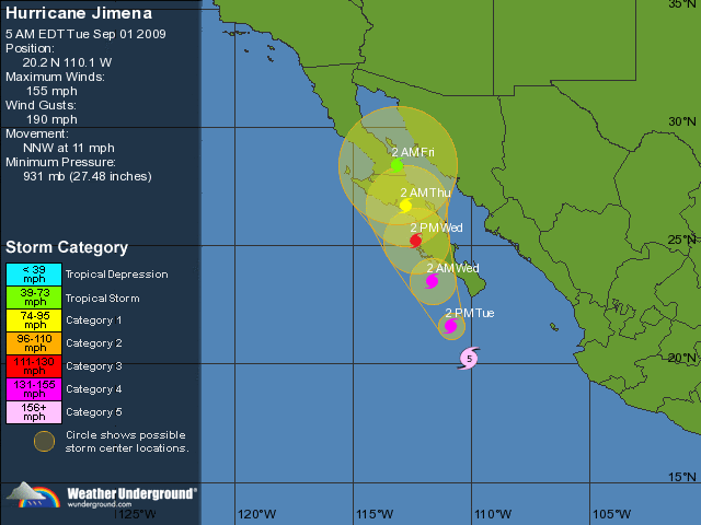
quote:Hurricane Jimena will threaten Cabo San Lucas and southern Baja California, Mexico, with hurricane conditions late Monday through Tuesday. Jimena has quickly become a large and powerful hurricane, reaching Category 4 strength Sunday morning. She was located about 515 miles south-southeast of the southern tip of Baja California. Winds had increased to 135 mph.
Squalls associated with Jimena will continue to affect the southwestern Mexican state of Jalisco. The weather in Cabo San Lucas and the rest of the southern Baja California will be hot and mostly dry today. Conditions will deteriorate on Monday. The outer rain bands will begin to affect the southern Baja. Hurricane-force winds will develop Tuesday. Winds over 100 mph are possible in Cabo San Lucas and the rest of the southern Baja Tuesday afternoon and Tuesday night.
In addition to the powerful winds, very heavy rain is also expected. The southern Baja is basically a desert, so heavy rain can quickly lead to flash flooding. A storm surge of more than 10 feet is possible as well.
Orkaan Jimena raast op Mexicaanse kusten af
Jimena, een orkaan van categorie 4 en dus "extreem gevaarlijk", heeft in de Stille Oceaan nog aan kracht gewonnen en bevindt zich momenteel op 400 km van de Mexicaanse kusten die hij dinsdag mogelijk bereikt, meldt de nationale meteorologische dienst van Mexico.
Tot 270 kilometer per uur
Jimena brengt rukwinden mee van 220 km/h en windstoten tot 270 km/h. Als Jimena op deze koers blijft, bereikt de orkaan dinsdagochtend mogelijk de Pacifische kust van de Mexicaanse deelstaat Neder-Californië. De meteorologische dienst waarschuwt de bevolking dan ook voor overstromingsgevaar en grondverschuivingen. (belga/vsv)

Wervelstorm trekt richting Tokyo
De wervelstorm Krovanh, die ontstaan is boven de Stille Oceaan, wordt vergezeld van rukwinden tot 80 knopen (144km/h). Vanochtend bevond hij zich bij het Japanse eiland Chichi-Jima en nu begeeft hij zich dus richting noordnoordwesten met een snelheid van 30 km/h.
Hoge golven
Volgens het instituut zou de cycloon maandagnamiddag Tokyo naderen. Het instituut voorspelt dan ook felle regen over de hoofdstad en waarschuwt voor harde wind en hoge golven.Krovanh zou Japan, dat vandaag een nieuw Lagerhuis kiest, een aantal uren na het sluiten van de stembussen moeten bereiken. (afp/eb)

PREPARATIONS TO PROTECT LIFE AND PROPERTY SHOULD BE RUSHED
TO COMPLETION.
Dat klinkt niet goed. Wat een monster is dit zeg!
TO COMPLETION.
Dat klinkt niet goed. Wat een monster is dit zeg!
's Avonds een man, overdags rustig an
Stevig beestje, is dit juist niet iets zeldzaams (tegenover de golf van Mexico) een CAT-5. Ik kan me zoiets niet voor de geest halen qua trajectorie.
http://en.wikipedia.org/w(...)5_Pacific_hurricanesquote:Op dinsdag 1 september 2009 00:31 schreef Drugshond het volgende:
Stevig beestje, is dit juist niet iets zeldzaams (tegenover de golf van Mexico) een CAT-5. Ik kan me zoiets niet voor de geest halen qua trajectorie.
http://en.wikipedia.org/wiki/Hurricane_Linda_(1997)

quote:Orkaan Jimena op weg naar Mexico
LOS CABOS - Orkaan Jimena is in de nacht van maandag op dinsdag aangezwollen tot een storm van categorie vijf, de zwaarste schaal om de kracht van orkanen te meten. Dat heeft het Amerikaanse orkanencentrum in Miami gemeld.
Jimena is met windsnelheden van 250 kilometer per uur op weg naar Mexico, maar zal naar verwachting niet meer zo sterk zijn als de storm dinsdagavond aan land komt. Dat gebeurt vermoedelijk in Baja California.
Toeristen in dat gebied besluiten veelvuldig hun vakantie vroegtijdig af te breken. De vakantiegangers vrezen dagen vast te zullen zitten zodra de orkaan aan land komt. De autoriteiten hebben de inwoners van het gebied opgeroepen zich zo goed mogelijk voor te bereiden op de komst van Jimena. Tienduizend mensen zijn geëvacueerd.
Overstromingen
Er wordt naast de stevige wind ook veel regen voorspeld. Door de droogte van de afgelopen tijd kan de grond de regenval waarschijnlijk niet aan, waardoor ook gewaarschuwd wordt voor overstromingen.
De haven van Cabo San Lucas is uit voorzorg gesloten, hoewel de orkaan daar waarschijnlijk niet overheen zal razen. Ook is een top van de de Organisatie voor Economische Samenwerking en Ontwikkeling (OECD) verplaatst van Los Cabos naar Mexico-Stad.
Het is nu weer een 4, maar het was gisteravond een 5 volgens mij. Dat was de verwachting ook, dat ie iets af zou zwakken voordat het land bereikt werd.
Volgens Wunderground is het nog steeds een categorie5. (155 mph = categorie5).
Wel precies op het randje, maar het is een cat 5.
[ Bericht 30% gewijzigd door #ANONIEM op 01-09-2009 15:31:58 ]
Wel precies op het randje, maar het is een cat 5.
[ Bericht 30% gewijzigd door #ANONIEM op 01-09-2009 15:31:58 ]
Jep...El Nino heerst ook in de Atlantic... niet in de Pacificquote:Op dinsdag 1 september 2009 15:34 schreef Tokamak het volgende:
El Niño was ongunstig voor orkanen toch?
Ook niet in de golf van mexico?quote:Op dinsdag 1 september 2009 15:38 schreef Frutsel het volgende:
[..]
Jep...El Nino heerst ook in de Atlantic... niet in de Pacific
Ik zeg het net wat krom 
El Nino slaat toe in de Pacific, daardoor zijn er minder orkanen in de Atlantische Oceaan en het Caraibische Gebied.
El Nino zelf komt niet voor in de Atlantische oceaan, maar is een Pacifisch verschijnsel dat de Atlantische oceaan beïnvloed. Eigenlijk beinvloedt het het weer overal ter wereld wel iets
El Niño: Terug van weggeweest?
Tijdens een el-nino is het water aan de westkust van Zuid Amerika en Noord Amerika warmer dus meer kans op orkanen. Tijdens non-el-nino jaren is dat effect dus veel minder aan de westkust, terwijl de Atlantic dan meer kans heeft op warmer zeewater en dus meer orkanen daar.
Ach de Noordzee is ook de Atlantic, dus de Golf van Mexico ook.quote:
Het was de zomer van 1969
Ik weet het nog zo goed
Het fietsenhok was leeg
Ik weet het nog zo goed
Het fietsenhok was leeg
Noordzee is 18 a 19 graden, golf van Mexico 32+quote:Op dinsdag 1 september 2009 16:40 schreef Fappie het volgende:
[..]
Ach de Noordzee is ook de Atlantic, dus de Golf van Mexico ook.
Ik ben op zoek geweest naar een beetje aardige webcam/stream maar helaas vrij weinig boeiends kunnen vinden. 
http://www.cabovillas.com/campage.asp?id=2 heeft wel een aardig plaatje maar deze refreshed bijna niet.
http://www.cabovillas.com/campage.asp?id=2 heeft wel een aardig plaatje maar deze refreshed bijna niet.
Always & Never
Even copy paste van een Mexicaanse nieuwssite:
Baja California Sur en emergencia por el huracán ‘Jimena’
México, 1 Sep (Notimex).- Ante el inminente impacto del ciclón tropical ‘Jimena’ en las próximas 24 horas, la Coordinación General de Protección Civil emitió una declaratoria de emergencia para los municipios de Los Cabos, La Paz y Comondú, en Baja California Sur.
El organismo dependiente de la Secretaría de Gobernación, informó en un comunicado que ante el posible impacto del fenómeno natural, se activaron los recursos del fondo revolvente del Fondo de Desastres Naturales (Fonden), para brindar ayuda inmediata a la población damnificada.
A partir de esta declaratoria, solicitada por el gobierno estatal, las autoridades contarán con los recursos del Fonden para atender las necesidades alimenticias, de abrigo y de salud de la población que resulte afectada.
Voor degenen die geen Spaans kunnen in het kort: De autoriteiten hebben een speciaal fonds opgericht om paraat te staan aan de provincie Baja California Sur tijdens en na de orkaan die binnen 24 uur aan land komt. Het overheidsorgaan belooft directe hulp in de vorm van voedsel, tijdelijke huisvesting en medicijnen voor alle getroffen gebieden.
Nou, dat gaat absoluut spoken daar.
Met een Cat 3 aan land......
ff een google maps linkje erbij gezocht.
http://maps.google.nl/?ie=UTF8&ll=24.856534,-112.005615&spn=4.365412,6.932373&t=h&z=7
Kan alleen nog geen webcam erbij vinden.
ff een google maps linkje erbij gezocht.
http://maps.google.nl/?ie=UTF8&ll=24.856534,-112.005615&spn=4.365412,6.932373&t=h&z=7
Kan alleen nog geen webcam erbij vinden.

Het kon nog weleens druk gaan worden in de Atlantische Oceaan.
quote:Elsewhere in the tropics
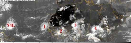
It's September, the most active month for hurricane activity in the Northern Hemisphere. There's every indication that the 2009 Atlantic hurricane season will have an active first half of September, since SSTs are 0.5 - 1.0°C above average, wind shear is near average, and the African monsoon is sending a long parade of African waves spinning off the coast of Africa. An IR satellite image from noon today shows this activity well (Figure 2). We can see a line-up of five African waves stretching from the Lesser Antilles to eastern Africa. The GFS model develops the waves numbered "2" and "3" into tropical depressions next week, and the waves labeled "1" and "4" also have a chance to develop into tropical depressions, as well. The wave labeled "1" is mentioned on NHC's Tropical Weather Outlook as having a low (less than 30%) chance of developing into a tropical depression by Thursday. This wave is under a moderate 10 - 15 knots of wind shear, and is over sufficiently warm waters (27 - 28°C) that some development may occur this week. The wave is far enough north that it will be hampered by dry air from the Sahara Desert.
quote:LOS CABOS, Mexico — Hurricane Jimena weakened to a Category 2 storm as it bore down on the coast of Mexico's Baja California peninsula.
Jimena's maximum sustained winds decreased late Tuesday to near 110 mph and the National Hurricane Center in Miami said it was expected to weaken further before making landfall Wednesday.
Jimena's change in status came a day after the hurricane brushed passed the resort towns at the southern tip of the Baja California, lashing them with driving rain and winds.
Despite the pummeling by the fringes of the then-Category 3 hurricane, the Mexican peninsula's biggest resort, Los Cabos, appeared to be escaping major damage beyond power outages and mud-choked roads.
Dozens of people evacuated from the Los Congrejos shantytown huddled in darkened rooms at a school after electricity failed during the storm. Trying to calm squalling babies and ignore hunger, the evacuees waited for dawn, and a chance to look at what the hurricane did to their homes made of plastic sheeting, wood and tar paper.
"Instead of giving out a few sheets of roofing every year, they should give us materials to build real houses — wood, or even bricks," said Paulino Hernandez, an out-of-work mason who sought haven at the school. "Every year it's the same thing: They (officials) give out a few sheets of roofing, and the next year it has to be replaced" when a hurricane comes.


quote:Aanzienlijke schade door Jimena
De orkaan Jimena heeft op het Mexicaanse schiereiland Neder-Californië aanzienlijke schade aangericht en mogelijk ook een eerste slachtoffer gemaakt. De civiele bescherming meldt dat een visser vermist is opgegeven.
"Er is een persoon vermist opgegeven in de gemeente San Buto", op ongeveer 200 km ten noorden van de zone waar de orkaan gisteren de kust bereikte, aldus een woordvoerder van de civiele bescherming. "Het gaat om een visser die sinds dinsdag niet meer gezien is. Het is niet duidelijk of hij door een stortvloed is meegevoerd of dat hij zich op zee bevond."
De orkaan heeft tientallen huizen verwoest. Meerdere dorpen en steden kwamen zonder stroom te zitten, telefoonverkeer was op veel plaatsen onmogelijk en meerdere dorpen zijn door overstromingen van de buitenwereld afgesneden. (afp/adv)
quote:What is Erika gonna do
I cannot recall a more interesting situation as far as the future of a tropical storm like we are seeing with Erika right now. The NHC is continuing advisories on the poorly organized storm but looking at satellite pictures alone, you would think it was a well developed hurricane. The issue is, according to the latest discussions from the NHC, dry air and strong winds at just the right layers of the atmosphere.
These negative parameters are just enough to keep Erika firmly in check and may weaken it enough to be downgraded to a well defined tropical wave again. However, it is worth noting that the GFDL and HWRF models insist that Erika will become a major hurricane over the next five days as it travels just north of the Greater Antilles and towards the Bahamas.
What I do not understand is how these modern and seemingly reliable models can depict such a contrasting solution to what the NHC is forecasting: dissipation. Their reasoning has more to do with increasing strong winds aloft than anything- enough so that the official forecast calls for Erika to basically fade away as it travels west-northwest.
Yet, the GFDL and HWRF show robust intensification in to a strong hurricane along almost the same path that the NHC plots. So who will be right? The models or the humans? Computers are machines designed by people and so they are certainly prone to making mistakes- as we humans are. So it is likely that the human interpretation of the real world will win out and Eika will in fact die off and be of little concern to anyone. That is what seems most likely but it is not a guarantee. The old "what if?" keeps creeping in to my mind and believe me, Mike, Jesse and I have all talked about it at great length between yesterday and right now. Heck, even the Navy's NOGAPS model shows Erika making a comeback over a week from now with a strong storm or hurricane parked off the North Carolina coast.
So you see the dilemma that is inherent to this situation. I do not want to create something out of nothing when the people in charge of the forecasts present compelling evidence as to why this thing will die off. But so far, it is still there and looking fairly healthy considering the hostile environment. One thing is certain- unsettled weather will rule the picture over the Lesser Antilles and spread towards Puerto Rico today and tomorrow. Without this even having a name would not limit the heavy rains and gusty winds that are in store for much of the northeast Caribbean

quote:the center of Erika is exposed as a low-level swirl moving out ahead
of the waning deep convection over the Leeward Islands. The Air
Force Reserve reconnaissance hurricane hunter aircraft found a
minimum pressure of 1007 mb...but were unable to find any winds to
support tropical storm status. As a result...Erika is downgraded to
a tropical depression on this advisory.
The initial motion estimate is 280/10...well to the south of the
previous official forecast track and the majority of all the model
guidance. Since Erika should move with the low-level flow...the
shallow BAM model was followed closely for the new forecast track.
This forecast turns Erika toward the west-northwest...taking the
cyclone or its remnant low south of Puerto Rico and over Hispaniola
...Where the low-level center will likely dissipate over the rugged
terrain in 48 hours.
The official forecast assumes that Erika will have a difficult time
sustaining any deep convection as it moves into an environment of
increasing shear and dry air in the lower to mid-troposphere. Erika
is maintained as a tropical depression through 12 hours...and is
forecast to be a remnant low by 24 hours....although this could
occur sooner if the convection east of the low-level center over
the Leeward Islands continues to weaken. It is also possible that
the center of Erika could become poorly defined and the cyclone
could devolve into a tropical wave at any time. Even if Erika loses
tropical cyclone status...its remnants could produce heavy rainfall
over the Greater Antilles.
Forecast positions and Max winds
initial 03/2100z 16.7n 65.3w 30 kt
12hr VT 04/0600z 17.2n 66.8w 30 kt
24hr VT 04/1800z 18.1n 68.6w 25 kt...remnant low
36hr VT 05/0600z 18.9n 70.3w 20 kt...remnant low
48hr VT 05/1800z 19.5n 72.2w 20 kt...dissipating inland
72hr VT 06/1800z...dissipated
$$
forecaster Brennan
Er lijkt weer iets aan te komen vanaf Afrika.. Eens kijken of dit nu eens naar het westen gaat i.p.v. noorden.
's Avonds een man, overdags rustig an

tja... misschien dat dat Fred wordt, maar de condities zijn ongunstig om een lang leven te leidenquote:Weak season, but why?
The experts said that the hurricane season would likely be a weak one. So far, they have been spot on. Only hurricane Bill, which did become a category four, was much of a threat to anyone. Everything else has been about as poor as you could ever see from the tropics. But why has it been like this? One year ago we were tracking hurricane Ike which would go on to become a top-5 hurricane in United States' history. It came on the heels of hurricane Gustav which itself set records for wind speeds in Cuba. How can things be so dramatically different the very next year? Some blame it purely on El Nino but that is too simple. There are other larger forces at work here including cooler than normal sea surface temps in portions of the Atlantic where they need to be warmer in order to promote an unstable environment in which thunderstorms can develop and sustain. There is also a lot of sinking, dry air evident in the deep tropics, this too adds to the hostile conditions and goes strongly against development of tropical cyclones. Add to that what appears to be a weaker than normal Bermuda High, which allows strong upper level energy to dig off and near the East Coast, and you have the makings of a paltry hurricane season. Erika is a classic example of this even though some of the computer models insisted it would become a powerful hurricane. Those computer models are wrong, Erika is no longer a concern except for some rain associated with the low pressure trough that created it in the first place.
So what lies ahead for the rest of the season? It is only September 4 and yes, a lot can happen in the next six weeks or so that remains in the traditional meat of the season. We do see a few tropical waves across the eastern Atlantic that are moving westward in stealth mode- meaning they are essentially naked of any deep convection. They too will probably reach 50W longitude and begin to flare up, only to be snuffed out by hostile conditions. Of course, we know better than to completely dismiss the rest of the season as there is time for one to get through and ruin everything. In my opinion, the odds are against that happening but since we do not know for sure what lies ahead, we'll keep an eye out just in case
Behoorlijke pluk in de Golf van Mexico nu zelf. Heeft misschien ook nog wel potentie om te ontwikkelen tot Grace
Zozo, Fred is inmiddels al cat. 3! Kan nog cat. 4 worden binnen 12 uur.
's Avonds een man, overdags rustig an
Uiteindelijk alleen maar goed nieuws natuurlijk als zowel Fred als Linda het land niet raken. Echter wil je stiekem natuurlijk ook mooie plaatjes zien. Maar van zowel Fred als Linda hoeven we niks bijzonders te verwachten denk ik. Hoogstwaarschijnlijk dat we van Fred in een latere vorm nog wat troep over ons land gaan krijgen.

Eind september misschien dus weer wat meer aktiviteit voor de Atlantische Oceaan/Golfregioquote:Meanwhile, hurricane Fred continues to move slowly in the eastern Atlantic as it also weakens due to fairly hostile conditions. The interesting the thing about Fred is that the GFS model in particular, which goes out to 384 hours on each run, shows Fred's remnant low pressure area coming all the way back to Florida in about 10-11 days. It shows up as a tropical wave really with not much energy but it is there. It would be quite remarkable if it were to hold together enough to be of concern.
One reason I am interested in this a little more than usual is due to a pattern change that appears to be coming. Right now, most of the Atlantic is quite unfavorable for tropical storm formation. This is due to strong winds in the upper layers of the atmosphere as well as sinking, converging air. To get tropical storms and hurricanes, you need to see air in the upper levels that is diverging or spreading out as we would see with a large upper anticylone.
The latest GFS MJO forecast, which goes out to 15 days, indicates that the current negative pattern will cease and switch to one that is quite a bit more favorable- right at the end of the month and in to early October. This has to be watched closely as it is my belief, based on looking at longer range models, that the Caribbean Sea and Gulf of Mexico could get more active in the coming weeks.
It makes sense too climatologically as we begin to shift away from the eastern Atlantic and focus more on the western Basin towards the end of September. Let me be clear- there are no indications that a hurricane is in the works for any location. As I talk about often, these are just pieces of a large puzzle that we try to put together to figure out the picture of what may lie ahead in the tropics. What I see is the chance of a more favorable development pattern evolving. Whether or not anything actually happens during that pattern remains to be seen.