WKN Weer, Klimaat en Natuurrampen
Lees alles over het onstuimige weer op onze planeet, volg orkanen en tornado's, zie hoe vulkanen uitbarsten en hoe Moeder Aarde beeft bij een aardbeving. Alles over de verwoestende kracht van onze planeet en tal van andere natuurverschijnselen.


Hier is dan het nieuwe topic voor Hurricane Season 2008 voor zowel Atlantische, Indische als Pacifische stormen.
Algemene Info
Met de term 'Hurricane Season' bedoelden we in eerste instante de periode van 1 juni tot 30 november.
Deze periode wordt in het Atlantische basin en de Golf van Mexico gezien als het Stormen-seizoen. Echter komen deze geweldadige stormen overal in de wereld voor en met name in Azië zorgen ze jaarlijks voor duizenden slachtoffers en tienduizenden daklozen. Echter horen we vaak erg weinig over de stormen in Azië en juist meer over die in de VS.
In de laatste jaren zijn Tropische Stormen meer en meer in de media gekomen. Het lijkt ook alsof ze meer en meer slachtoffers maken. Een documentaire over Hurricane Andrew uit 1992, heeft diepe indruk gemaakt en ook zullen kenners orkanen Floyd, Gilbert, Stan en Ivan zich zeker nog herinneren. De catastrofe die "Katrina" met zich meebracht ging de hele wereld over. En dan praten we eigenlijk alleen over de Atlantische stormen en lijken we te vergeten dat er vorig jaar 4000 doden vielen in Bangladesh door orkaan Sidr.
Hoewel het Atlantische seizoen pas officieel in juni begint zijn er op andere plekken in de wereld zeker meer orkanen te vinden in de komende maanden. We zullen ook deze dus zeker gaan bespreken. Waarschijnlijk zal de kern van de discussie en de posts gaan over de periode 1-6-2008 t/m 30-11-2008. T.z.t. zal er ook wel een NWS-topic worden geopend als een orkaan ook uitgebreid in het nieuws komt.
Orkanen: Hoe ontstaan ze eigenlijk?
op de site van Wikipedia kan je in het Nederlands nalezen hoe ze ontstaan en wat de belangrijkste energiebron is voor hun verwoestende kracht: het warme zeewater http://nl.wikipedia.org/wiki/Orkaan#Ontstaan
Ook de BBC heeft er een interessante en leuke animatie over gemaakt. Ook wordt er op LiveScience in het engels prima uitgelegd hoe ze ontstaan en zich ontwikkelen
Indeling en Kracht
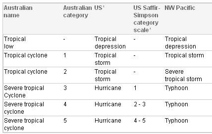
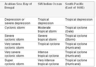
De stormen worden ingedeeld op 'categorie'. Vaak zijn het eerst tropische stormen" (Tropical Depression, Tropical Storms), die overgaan op Orkaanstatus (Hurricane/Tyfoons) Ze worden ingedeeld op windsnelheden via de Saffir-Simpson Schaal
Tropical Depression 24-38 mph winds (38-61 km/u)
Tropical Storm 39-73 mph winds (62-118 km/u)
Hurricane Categorie 1 74-95 mph winds (119-153 km/u) -- 4/5 ft Storm Surge -- Vb. Danny 1997, Stan 2005
Hurricane Categorie 2 96-110 mph winds (154-177 km/u) - 6/8 ft Storm Surge -- Vb. Danielle 2004
Hurricane Categorie 3 111-130 mph winds (178-209 km/u) - 9/12 ft Storm Surge - Vb.Fran 1996, Beta 2005
Hurricane Categorie 4 131-155 mph winds (210-249 km/u) - 13/18 ft Storm Surge - Vb.Hugo 1989, Frances 2004
Hurricane Categorie 5 > 156 mph winds (meer dan 250 km/u) -- 18ft or more S.S. -- Vb.Andrew 1992, Mitch 1998 en Wilma, Katrina 2005
Namen
De stormen, die vaak gevormd worden op de atlantische oceaan en dan richting de Caribbean of de Oostkust van de VS gaan, krijgen de naam op Alfabetische volgorde. Voor het seizoen 2005 zijn de namen als volgt:
Atlantische Stormen 2008
Arthur, Bertha, Cristobal, Dolly, Edouard, Fay, Gustav, Hanna, Ike, Josephine, Kyle, Laura, Marco, Nana, Omar, Paloma, Rene, Sally, Teddy, Vicky, Wilfred
In het oosten van de pacific ontstaan ook Hurricanes, ook wel Cylonen en/of Tyfoons genoemd. Deze zorgen vaak voor weinig schade aan de Amerikaanse westkust.
Oost Pacifische Stormen 2008
Alma, Boris, Cristina, Douglas, Elida, Fausto, Genevieve, Hernan, Iselle, Julio, Karina, Lowell, Marie, Norbert, Odile, Polo, Rachel, Simon, Trudy, Vance, Winnie, Xavier, Yolanda, Zeke
Verder zijn er dan nog de stormen in het Noorden, Zuiden en Westen van de Pacific. Met name de stormen in het Noord/Westen komen vaak in het nieuws omdat ze Japan, de Filipijnen, Taiwan en China vaak teisteren, maar ook geheel Zuid Oost Azie kunnen treffen. Meer informatie en de namen van deze stormen zijn hier terug te vinden.
Wanneer zijn die seizoenen nou precies?
ATLANTIC: 1 juni t/m 30 november
NORTH EAST PACIFIC Begin mei t/m begin November, met piek in Augustus/September
NORTH WEST PACIFIC Begin juli t/m eind November, maar eigenlijk hele jaar door aktiviteit.
NORTH INDIAN April t/m December met pieken in Mei en November
SOUTH INDIAN + WEST AUSTRALIAN Oktober t/m Mei met pieken in Februari en April
SOUTH WEST PACIFIC + EAST AUSTRALIANOktober tot eind April met piek in Februari.
Over het algemeen is Mei de rustigste maand en September de zwaarste.
Hoe ziet de voorspelling voor 2008 eruit
Volgens Phil Klotzbach en William Gray van CSU wordt 2008 een gemiddeld orkaanseizoen. Volgens hun ontstaan er 13 stormen die een naam krijgen, waarvan er 3 orkanen worden van categorie 3 of hoger. Ze verwachten een seizoen, redelijk gelijk aan de stormen van 2007. De voorspelling werd op 8 december 2007 gedaan.
Meer hierover kan je hier lezen.
Oude Delen
2004 - Deel 1 en Deel 2
2005 - Deel 1 en Deel 2
2006 - Deel 1 en Deel 2
2007 - Deel 1, Deel 2, Deel 3 en Deel 4
Enkele Links
1. National Hurricane Centre
2. Carribean Storm Network
3. Hurricanezone
4. Hurricane Track
5. Website met satelietbeelden van de Caribbean en de rest van Amerika
6. Intellicast: Geavanceerde satellietfoto's en gifs van aktuele stormen
7. Tropical Weather Underground
8. Tropical Storm Risico's van dit moment
9. Wikipedia Hurricanes/Tyfonen in het algemeen
10. Alle stormen ter wereld van de laatste jaren in overzicht
11. The StormTrack
12. Orkanensite in de Filipijnen
Opmerkelijke Links
Hurricane Season Special Edition Pagina van CNN van 2006
-- Hurricane Katrina CNN Special Report of the Killer Hurricane
-- Hurricane Katrina via WikiPedia
-- Hurricane Season 2005 -- Special van CNN
-- Hurricane Season 2004 -- Special van CNN
– Overzicht van Atlantische Stormen uit 2005
-- Spectaculaire Satelietshots van stormen
--Animatie van de alle Atlantische Stormen uit 2004
Openingspost
volgt nog
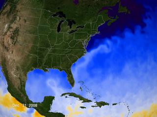
Actuele Radar in Golf van Mexico

Water temperatuur.

=====================
Post hier je gegevens, berichten, data en opmerkelijke zaken over Orkanen, Tyfoons en Hurricanes en van 2008.
[ Bericht 0% gewijzigd door Frutsel op 24-07-2008 09:43:45 ]

Mooie uitgebreide OP 
Op zaterdag 15 augustus 2009 23:05 schreef eer-ik het volgende:
Ik vind je sig nogal denigrerend.
Ik vind je sig nogal denigrerend.
quote:La Nina brews destructive cyclones off Australia 03 Jan 2008 04:15:30 GMT
Source: Reuters
By Michael Perry
SYDNEY, Jan 3 (Reuters) - A mature La Nina now exists over the Pacific and could produce up to 13 cyclones in Australia's current storm season, along with increased rainfall over the drought-hit nation, weather officials said on Thursday.
Every 30 years Australia's cyclone season, from November to April, reaches a peak and some forecasters say 2008 may become a peak storm season due to La Nina, which produces colder than average seas along the equator forcing warmer waters around Australia's northern coastline and fuelling cyclones.
Australia's northeast coast has been hit by one cyclone and is currently being battered by a severe storm with cyclonic winds, generating huge waves which closed scores of beaches, and caused coastal flooding and the evacuation of tourists.
A second cyclone is expected to form in the next few days in the Gulf of Carpentaria in northern Australia. Only two cyclones developed off the northeast coast last season.
Australia's northwest coast was last week buffeted by a cyclone, temporarily halting offshore oil and gas production.
"Now that La Nina is fully established one would think an above average cyclone season would probably occur," said Jim Davidson, regional director with the government's Bureau of Meteorology in the tropical Australian state of Queensland.
"Probably 12 or 13 (cyclones) in the Australian region," Davidson told Reuters on Thursday.
Australia's National Climate Centre said a weak La Nina over the Pacific had strengthened and was now a "mature event".
"A La Nina event is firmly established in the Pacific, strengthening over the past month and contributing to the enhanced eastern Australian rainfall since November," said the Centre's latest La Nina report released on Wednesday.
bron
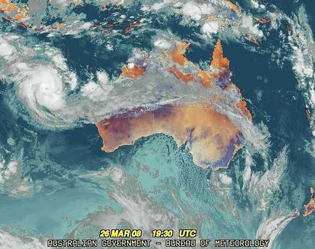
Voor de kust van Darwin ( Australie ) is op dit moment een tropical low. Er wordt verwacht dat dit systeem binnen 12 uur zal uitgroeien tot een tropische storm. Het lijkt dus zeker wel een heftig seizoen te gaan worden daar in Australie.
Maar als er in de Atlantische Oceaan vorig jaar niet zo veel windshear was dan waren er denk ik wel 25 stormen of meer geweest.
Maar als er in de Atlantische Oceaan vorig jaar niet zo veel windshear was dan waren er denk ik wel 25 stormen of meer geweest.

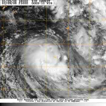
Tropical Cyclone Melanie
Tropical Cyclone Melanie had an impressive appearance on December 30, 2007, as the storm swirled off the coast of Western Australia. Fortunately, the storm, which had sustained winds of 125 kilometers per hour (70 miles per hour), did not come ashore, and it brought only moderate storm conditions to the sparsely populated coast.
The Moderate Resolution Imaging Spectroradiometer (MODIS) on NASA’s Aqua satellite acquired this photo-like image at 2:10 p.m. local time (6:10 UTC) on December 20, 2007. The storm had basic spiral structure, with long arms of cloud wrapping around its center in a clockwise direction (characteristic of Southern Hemisphere cyclones). However, the storm system lacked a distinct eye, one indicator that it was not a powerful storm.
bron:
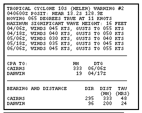
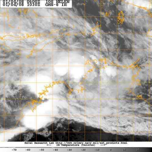

Cyclone Helen gaat veel neerslag achterlaten. Er wordt rond de 18 cm verwacht en golven rond de 5 meter...
[ Bericht 0% gewijzigd door #ANONIEM op 04-01-2008 13:16:12 ]
quote:Cyclone Helen due to hit NT coast
Email Print Normal font Large font January 4, 2008 - 7:24PM
Territorians were preparing for a night of fierce winds and violent rain across the Top End, as tropical cyclone Helen edges closer to the coast.
Gale force winds are expected to hit the Darwin region about 9pm (CST) on Friday night, with police calling on locals to make final preparations to their homes and stay indoors.
A cyclone warning has been declared for the capital and the Tiwi Islands, as well as all coastal communities between the remote Aboriginal community of Wadeye - otherwise known as Port Keats - and Cape Hotham.
Residents have been told to expect winds of up to 130km/h.
Meteorologist Gordon Jackson, from the Darwin Forecast Centre, said the cyclone would touch land - the point when winds are at their most intense - about 100km south-west of Darwin late on Friday night or early on Saturday.
As of 3.30pm, he said Helen was 225km west south-west of Darwin tracking at 16km/h.
"It is a Category 1 right now but we expect it to turn into a Category 2 over the next six hours," he told AAP.
"It's extremely unlikely it will reach a Category 3 before it crosses the coast."
Darwin has not been affected by a cyclone for a number of years although the infamous Cyclone Tracy devastated the city and killed 49 people on Christmas Eve in 1974.
There are concerns of major flooding across the Top End, including Wadeye, Daly River, Katherine and Adelaide River, 100km south of Darwin.
"There is going to be a lot of rainfall associated with the cyclone crossing the coast and there is a very good chance that there will be flooding in the low-lying areas and streams rising," said Todd Smith, duty forecaster at Darwin's cyclone warning centre.
Schools and day care centres within a 50km radius of Darwin were shut earlier on Friday. The cyclone warning also prompted the immediate closure of the Botanic Gardens, the Territory Wildlife Park and The Window on the Wetlands Visitor Centre on the Adelaide River floodplain.
Compass Resources has halted construction of a new mine at Batchelor, south of Darwin.
NT Police Commissioner Paul White urged people who intended to leave Darwin to escape the cyclone to do so immediately, although he added it was not a call to evacuate the city.
"I'm pleased with the level of preparations so far and urge all people in the areas likely to be affected to continue preparations," Comm White said in a statement.
"Those members of the public who as part of their cyclone plan would be leaving Darwin should start their journeys out of Darwin as soon as possible."
Nightcliff Jetty was closed, while Darwin's harbour has locked down containers and floating pontoons, with commercial ships asked to leave the port.
Public shelters will be opened in and around Darwin from 6pm (CST).
Cyclone Helen is expected to weaken to below cyclone intensity over land on Friday, but it may redevelop in the Gulf of Carpentaria on Sunday.
A cyclone warning was cancelled for Kalumburu in Western Australia late on Friday, and a cyclone watch was declared for coastal and island communities from Elcho Island to Numbulwar.
[ Bericht 0% gewijzigd door #ANONIEM op 04-01-2008 13:16:12 ]
Cyclone Helen is een categorie 2, (Tropische storm volgens de Saffir Simpson schaal) zal over land afzwakken om vervolgens te herstellen boven de the Gulf of Carpentaria
[ Bericht 1% gewijzigd door #ANONIEM op 04-01-2008 13:48:14 ]
quote:At 6:30 pm CST Tropical Cyclone Helen, Category 2 was estimated to be
95 kilometres west of Daly River Mouth and
185 kilometres west southwest of Darwin and
moving east at 15 kilometres per hour.
The cyclone is expected to cross the coast near Daly River Mouth in the next few
hours. Tropical Cyclone Helen is expected to weaken below cyclone intensity over
land tomorrow, but may continue to move east and redevelop in the Gulf of
Carpentaria on Sunday.
DESTRUCTIVE WINDS with gusts to 130 kilometres per hour are expected to affect
coastal and island communities between Darwin and Daly River Mouth in the next
few hours.
GALES with gusts to 100 kilometres per hour are currently being experienced on
parts of the coast between Darwin and Port Keats, and may extend to Cape Hotham
and the Tiwi Islands later tonight. These conditions are expected to continue
for the next 6 to 12 hours.
GALES with gusts to 100 kilometers per hour may affect coastal and island
communities between Elcho Island and Numbulwar, including Nhulunbuy and Groote
Eylandt, on Sunday if the system redevelops in the Gulf of Carpentaria.
Heavy rain is expected to cause flooding over the Top End.
[ Bericht 1% gewijzigd door #ANONIEM op 04-01-2008 13:48:14 ]
De schalen die in verschillende gebieden (anders) wordt gebruikt
[ Bericht 39% gewijzigd door #ANONIEM op 04-01-2008 13:44:54 ]
[ Bericht 39% gewijzigd door #ANONIEM op 04-01-2008 13:44:54 ]
Tropische storm Helen neemt boven land nog in kracht toe.
temperatuur water Australie
temperatuur water Australie
quote:The Bureau of Meteorology says Tropical Cyclone Helen has not weakened, despite being over land for a few hours.
A cyclone warning is current for coastal and island communities from Port Keats to Cape Hotham, including Darwin and the Tiwi Islands.
A cyclone watch is current for coastal and island communities from Elcho Island to Numbulwar, including Nhulunbuy and Groote Eylandt.
The category two system is estimated to be 100 kilometres south-south-west of Darwin and moving east at 18 kilometres per hour.
Cyclone Helen crossed the coast near Channel Point about 11:00pm (ACDT) and is currently situated between Channel Point and Adelaide River.
The bureau says because the cyclone kept its structure so well, the strong winds might extend through Adelaide River over the next few hours.
Power out, gale force winds as Cyclone Helen batters NT
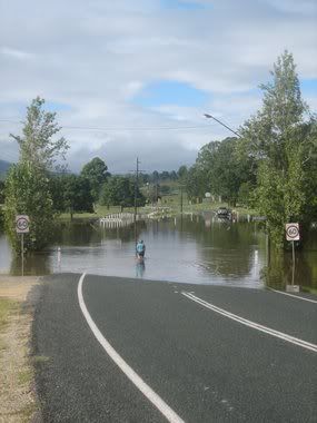
Evacuaties Australië na overstromingen
SYDNEY - De Australische autoriteiten hebben zaterdag in het oosten van het land vijfhonderd mensen geëvacueerd wegens overstromingen als gevolg van zware regenval.
Veel mensen zaten vast in hun huizen, caravans en auto's. Het noodweer is een uitloper van de cycloon Helen, die inmiddels is afgezwakt tot een zware storm.
De afgelopen week zijn rivieren in Queensland en New South Wales buiten hun oevers getreden. Voor zover bekend zijn er geen gewonden of doden.
Nu.nl
[ Bericht 6% gewijzigd door #ANONIEM op 05-01-2008 11:12:43 ]
Duizenden Australiërs ingesloten door hoogwater
CANBERRA - Duizenden Australiërs in de deelstaten New South Wales en Queensland zijn ingesloten geraakt door grootschalige overstromingen als gevolg van aanhoudend noodweer.
De schade loopt in de miljoenen, melden Australische kranten in hun maandagedities.
Afgesloten
De autoriteiten hebben al gezegd dat sommige gemeenschappen waarschijnlijk nog dagen van de buitenwereld afgesloten zullen zijn.
Wegen zijn verwoest en bruggen zijn weggeslagen. In sommige districten is de noodtoestand van kracht om zo de komst van federale hulp te kunnen versnellen.

van deze site http://www.fvalk.com/day_image.htmquote:Op maandag 7 januari 2008 20:34 schreef Frutsel het volgende:
Waar haalde je die foto's ook alweer vandaan Aloa?
Hmm... komt me niet bekend voorquote:Op maandag 7 januari 2008 21:30 schreef aloa het volgende:
[..]
van deze site http://www.fvalk.com/day_image.htm
misschien bedoelde je dezequote:Op maandag 7 januari 2008 21:32 schreef Frutsel het volgende:
[..]
Hmm... komt me niet bekend voorThx
wereldkaart
Bangladesh to build 2,000 cyclone shelters in 2008
DHAKA, Jan 8 (Reuters) - Bangladesh, still struggling to overcome the devastating effects of cyclone Sidr late last year, will build 2,000 new storm shelters in 2008.
"Some 2,000 new cyclone shelters will be built in 15 low-lying coastal districts, which had been trampled by the Nov. 15 cyclone," Food and Disaster Management Secretary Mohammad Ayub Miah told Reuters on Tuesday.
The worst cyclone since 1991 killed more than 3,300 people, made millions homeless and washed away around 1 million tonnes of rice, the country's main staple food.
The disaster-prone south Asian country of more than 140 million people currently has around 1,500 shelters, each capable of offering refuge to up to 5,000 people on average, officials said.
During storms and floods, people also take shelter in high-rise buildings, including schools.
Aid agencies say Bangladesh has made huge strides in reducing death tolls from the cyclones that batter its coastline every year due to improved preparedness measures.
These include advance warnings, quick removal of people from disaster areas and better rescue and relief operations.
Bangladesh's worst cyclone in 1991 killed around 140,000 people. (Reporting by Ruma Paul; writing by Anis Ahmed; Editing by Alex Richardson) (Bron: Reuters)

Cyclone Helen hits Northern Australia
A variety of weather phenomena combined to deliver heavy rains to parts of Australia in the first week of January 2008, bringing a mixture of drought relief as well as some severe flooding. A substantial amount of rain along the northern coastline was due to Cyclone Helen, which formed in the southeastern Timor Sea area (image left) off the western coast of the Northern Territory.
This image shows rainfall totals across northern Australia between January 1-8, 2008, based on data from near-real-time, Multi- satellite Precipitation Analysis (MPA) at NASA Goddard Space Flight Center. The MPA is based in part on data from the Tropical Rainfall Measuring Mission (TRMM) satellite. The highest rainfall totals for the period (shown in dark red) are over 500 millimeters (~20 inches) in the eastern Gulf of Carpentaria (right of center). Over land, a broad area of 100 millimeters (~4 inches) extends from the northern coastline of Western Australia across the Northern Territory and into the York Peninsula in the east (green areas).
Even before Cyclone Helen, the northern coastline of Australia was already experiencing wet weather due to the interaction of monsoon rains with the Madden-Julian Oscillation (MJO). The MJO is a periodic atmospheric disturbance during which a large area of thunderstorms bubbles up in the Indian Ocean and slowly drifts eastward into the Pacific over the course of 30–60 days. The most recent MJO event was moving into the western Pacific Ocean in early January.
bron:
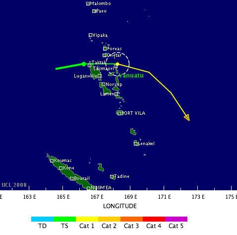
Tropical Storm FUNA
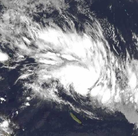
quote:Tropical storm Funa is forecast to strike Vanuatu as a tropical cyclone at about 06:00 GMT on 17 January. Data supplied by the US Navy and Air Force Joint Typhoon Warning Center suggest that the point of landfall will be near 14.8 S, 168.2 E. Funa is expected to bring 1-minute maximum sustained winds to the region of around 120 km/h (74 mph). Wind gusts in the area may be considerably higher.
According to the Saffir-Simpson damage scale the potential property damage and flooding from a storm of Funa's strength (category 1) at landfall includes:
Storm surge generally 1.2-1.5 metres (4-5 feet) above normal.
No real damage to building structures.
Damage primarily to unanchored mobile homes, shrubbery, and trees.
Some damage to poorly constructed signs.
Some coastal road flooding and minor pier damage.
There is also the potential for flooding further inland due to heavy rain.

Tropical storm Fame is forecast to strike Madagascar as a tropical cyclone at about 18:00 GMT on 27 January. Data supplied by the US Navy and Air Force Joint Typhoon Warning Center suggest that the point of landfall will be near 15.9 S, 44.1 E. Fame is expected to bring 1-minute maximum sustained winds to the region of around 120 km/h (74 mph). Wind gusts in the area may be considerably higher.
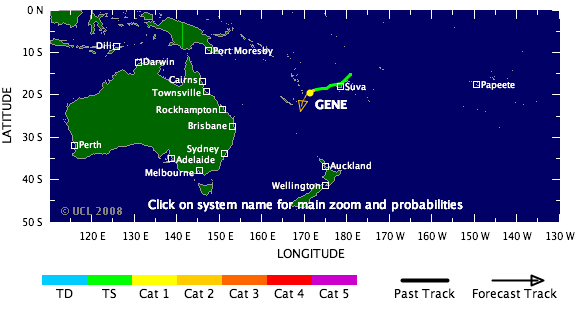
Twee doden door tropische storm Fiji
De tropische storm Gene is dinsdag over Fiji getrokken. Daarbij zijn twee mensen om het leven gekomen.
Gene is dwars over de eilanden getrokken en zorgde voor windstoten tot 140 kilometer per uur. Huizen raakten beschadigd en elektriciteitsleidingen knapten af. Twee mensen werden geëlektrocuteerd, toen ze in aanraking kwamen met stroomvoerende delen.
Gene is ondertussen uitgegroeid tot een orkaan en onderweg naar New Caledonia.
www.vwkweb.nl
[ Bericht 49% gewijzigd door #ANONIEM op 29-01-2008 22:16:59 ]
De tropische storm Gene is dinsdag over Fiji getrokken. Daarbij zijn twee mensen om het leven gekomen.
Gene is dwars over de eilanden getrokken en zorgde voor windstoten tot 140 kilometer per uur. Huizen raakten beschadigd en elektriciteitsleidingen knapten af. Twee mensen werden geëlektrocuteerd, toen ze in aanraking kwamen met stroomvoerende delen.
Gene is ondertussen uitgegroeid tot een orkaan en onderweg naar New Caledonia.
www.vwkweb.nl
quote:Cyclone pummels Madagascar, kills two
29 Jan 2008 16:59:38 GMT
Source: Reuters
ANTANANARIVO, Jan 29 (Reuters) - A cyclone has killed two people in Madagascar and caused widespread damage to the world's fourth largest island, a senior relief official said on Tuesday.
"(Cyclone) Fame has killed two people, a child in Majunga, carried away by the waters, and a man," said Jean Rakotomalala, executive secretary of the Malagasy government's National Office of Disasters and Risk Management.
"The material damage is enormous in all four districts of Melaky region," he told journalists.
The cyclone hit the Indian Ocean island's west coast on Sunday, leaving several hundred families in need of emergency assistance. It has since moved on.
Last year, six cyclones hit the island killing at least 150 people and destroying homes and crops in Madagascar's worst season on record. (Reporting by Fanja Saholiarisoa; Writing by Ed Harris; Editing by Ana Nicolaci da Costa)
[ Bericht 49% gewijzigd door #ANONIEM op 29-01-2008 22:16:59 ]


Warmer oceaanwater leidt tot meer orkanen
Een nieuwe studie wijst uit dat bij stijging van de temperatuur van het oceaanwater in het ontstaans-gebied van orkanen, er meer orkanen ontstaan. Binnenkort wordt de studie in Nature gepubliceerd.
Slechts de stijging van 1 graad Fahrenheit (ca. 0.56 graden Kelvin of Celsius)is oorzaak van het ontstaan van 50% meer orkanen.
Klimaatwetenschappers weten uiteraard al lang dat orkanen hun energie vanuit het warme oceaanwater putten, dus des te warmer het water is des te meer orkanen er zijn en des te krachtiger ze zijn. In de studie is gekeken naar de relatie tussen voorkomen en sterkte van orkanen enerzijds
en watertemperatuur anderzijds. Het zou kunnen helpen verklaren waarom in de afgelopen 12 jaar
de frequentie en sterkte van orkanen toegenomen is.
Mark Saunders concentreerde zich op de watertemperatuur in een band die zich uitstrekt van rond Puerto Rico en de noordkust van Zuid-Amerika oostwaarts naar de kust van Afrika. hij bestudeerde de gegevens vanaf 1950 tot nu en hij keek naar orkaanactiviteit vanaf 1965.
De gemiddelde watertemperatuur in die regio is 81 graden Fahrenheit, gevonden werd het volgende verband, iedere graad Fahrenheit verhoging resulteert in:
- een verhoging in aantal orkanen met windsnelheden boven 110 miles/uur met 45 %
- het absolute aantal (dus ongeachte de sterkte) neemt toe met 36%
- het aantal tropische stormen neemt toe met 31 %
Een voorbeeld: 2005 was het meest actieve orkanenseizoen tot nu toe geregistreerd,en het Atlantische water in het ontstaansgebied was de warmste in de meetreeks, 1.4 graden Fahrenheit boven normaal.
Dat seizoen werd er een nieuw recordaantal van 28 tropische stormen en 13 orkanen geboekt.
In 1971, toen het water het koelst was, waren er 13 stormen en 6 orkanen, in 2005 was de activiteit meer dan tweemaal zo hoog.
De verbanden lijken opvallend maar nog niet iedereen is overtuigd:
Chris Landsea (what's in a name) van National Oceanic and Atmospheric Administration wiens studies de verbanden tussen warmer klimaat en toename van orkanen niet ondersteunen, vond dat Saunder's studie niet ver genoeg terug gaat in tijd om natuurlijke cyclische fenomenen uit te sluiten als (mede-)veroorzakers van dat wat Saunder's claimt statistisch waargenomen en berekend te hebben.
www.vwkweb.nl
[ Bericht 0% gewijzigd door #ANONIEM op 31-01-2008 20:54:32 ]
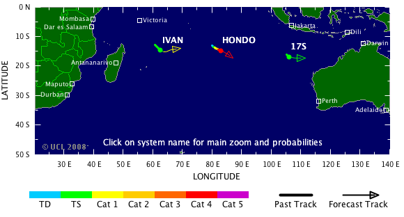
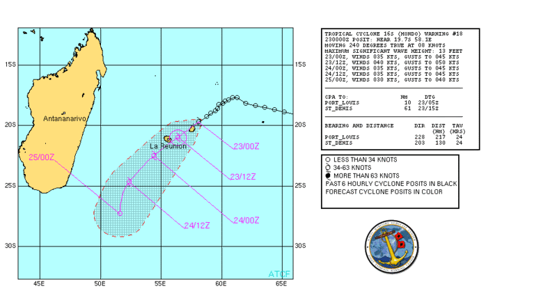
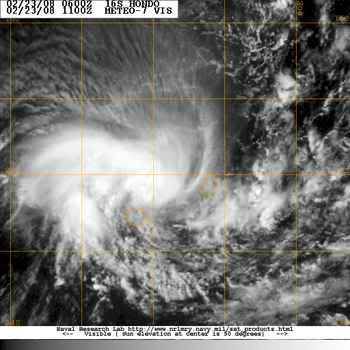
Hondo is een categorie4 geworden.
Geen enkel land is in zicht voor deze orkaan..
Geen enkel land is in zicht voor deze orkaan..
quote:Zware orkaan Hondo levert geen gevaar op
Woensdag is in de Indische Oceaan de orkaan Hondo in kracht toegenomen tot categorie 4.
De orkaan zorgt voor weinig gevaar. Met een snelheid van 7 kilometer per uur is het ruim 1350 kilometer verwijderd van het eiland Diego Garcia. Verder is er geen enkel eiland in de buurt te vinden. De komende dagen komt Hondo in koud water en neemt het systeem in kracht af.
www.vwkweb.nl
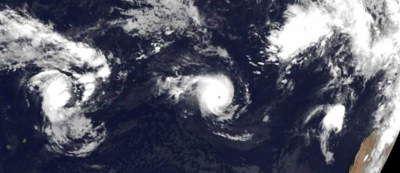

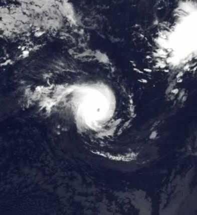
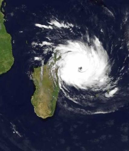
Cyclone Hondo
Cyclone Hondo was a powerful Category 4 storm when the Moderate Resolution Imaging Spectroradiometer (MODIS) on NASA’s Aqua satellite captured this photo-like image on the afternoon of February 7, 2008. The storm’s power is evident in its symmetric shape and well-defined eye. When MODIS took the image at 7:55 UTC, Hondo had winds of 220 kilometers per hour (140 miles per hour or 120 knots) with gusts to 270 km/hr (170 mph or 145 knots), said the Joint Typhoon Warning Center. The storm was traveling southeast across the southern Indian Ocean, far from any populated region.
Tropical Cyclone IVAN gaat nog flink in kracht toenemen.
Hondo komt in kouder water en verzwakt tot tropische depressie.
Hondo komt in kouder water en verzwakt tot tropische depressie.
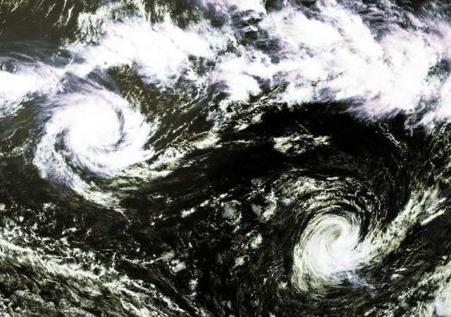
Tropical Cyclone IVAN gaat recht op Madagascar af. (als cat. 1)
Tropical Storm NICHOLAS trekt richting Australie als cat.1
Tropical Storm NICHOLAS trekt richting Australie als cat.1
Hoeveel Cyclonen zal Madagascar nog krijgen dit seizoen...
IVAN gaat als een categorie 3 op het eiland af.
Neerslagverwachting rond de 22 centimeter.
IVAN gaat als een categorie 3 op het eiland af.
Neerslagverwachting rond de 22 centimeter.

quote:Very intense tropical cyclone Ivan struck Madagascar as an intense tropical cyclone at about 06:00 GMT on 17 February. Data supplied by the US Navy and Air Force Joint Typhoon Warning Center suggest that the point of landfall was near 17.1 S, 49.7 E. Ivan brought 1-minute maximum sustained winds to the region of around 185 km/h (114 mph). Wind gusts in the area may have been considerably higher.
According to the Saffir-Simpson damage scale the potential property damage and flooding from a storm of Ivan's strength (category 3) at landfall includes:
Storm surge generally 2.7-3.7 metres (9-12 feet) above normal.
Some structural damage to small residences and utility buildings with a minor amount of curtainwall failures.
Damage to shrubbery and trees with foliage blown off trees and large trees blown down.
Mobile homes and poorly constructed signs are destroyed.
Low-lying escape routes are cut by rising water 3-5 hours before arrival of the centre of the storm.
Flooding near the coast destroys smaller structures with larger structures damaged by battering from floating debris.
Terrain continuously lower than 1.5 metres (5 feet) above mean sea level may be flooded inland 13 km (8 miles) or more.
Evacuation of low-lying residences within several blocks of the shoreline may be required.
There is also the potential for flooding further inland due to heavy rain.
The information above is provided for guidance only and should not be used to make life or death decisions or decisions relating to property. Anyone in the region who is concerned for their personal safety or property should contact their official national weather agency or warning centre for advice.
Cyclone hits Madagascar, threatens Mozambique
ANTANANARIVO, Feb 18 (Reuters) - At least 11 people are thought to have died after Madagascar was hit by Cyclone Ivan, a senior humanitarian official said on Monday, and the storm is also threatening Mozambique.
Ivan, one of the largest cyclones ever to hit Madagascar, was packing winds of more than 125 mph (200 kph) when it hit the Indian Ocean island's east coast, causing the collapse of a hotel where nine people were sheltering.
"One of the victims called her father in Antananarivo on Sunday at 0830 (0530 GMT). Since then we have heard nothing," Jean Rakotomalala, executive secretary of the National Office of Disasters and Risk Management, told journalists.
His office later confirmed two more deaths in another district.
Rakotomalala said he had been unable to contact eight eastern districts, while strong rain hit the entire country, prompting fears of flooding also in the capital, Antananarivo.
"Cyclone Ivan is one of the strongest storms to have hit the Big Island," he said.
Last year, six cyclones killed 150 people on Madagascar, destroying homes and crops in the island's worst season on record.
The world's fourth largest island is prone to frequent cyclones and tropical storms. This season's first cyclone, Cyclone Fame, killed at least 13 people.
Madagascar is the world's largest producer of vanilla and 85 percent of its population were living on less than $2 per day in 2005, according to official data.
Mozambique's National Meteorological Institute (INAM) said Ivan, a category 4 storm, had strengthened over the Indian Ocean and was likely to cause damage when it reached the coast.
"We are monitoring the situation very closely before we issue an alert," INAM said in a statement.
INAM said Ivan had gathered winds of up to 90 mph (150 kph) and could strengthen further.
Mozambique, Zambia, Zimbabwe and Malawi have been lashed by heavy rain for weeks, causing rivers to burst their banks and forcing thousands of villagers to flee flooded homes.
Mozambique's worst disaster in recent memory occurred in 2000-2001 when a series of cyclones worsened widespread flooding in southern and central parts of the country, killing 700 people and driving close to half a million from their homes.
Coral Bay on cyclone red alert
THE West Australian Pilbara town of Exmouth emerged largely unscathed from battering by tropical cyclone Nicholas which has now veered away from the tourist centre.
But residents around Coral Bay have been put on red alert, warning them to remain indoors, as the weakening cyclone bears down.
Exmouth had been placed on red alert today with residents taking shelter from potentially destructive winds.
But the town withstood it well.
By 9pm (WDT) last night the category two cyclone was about 60km south-west and 90km north of Coral Bay, moving south at 11km/h, the Bureau of Meteorology (BOM) said.
The cyclone is very close to the coast, and although it is weakening, has wind gusts of up to 130km/h, which are expected to affect western coastal areas between North West Cape and Coral Bay.
Gales of up to 100km/h are affecting North West Cape now, and are expected to move south towards Coral Bay overnight. They could extend further south to Carnarvon tomorrow.
Higher-than normal tides are expected on the southern side of Exmouth Gulf and over west coastal parts between Coral Bay and North West Cape tonight, with very rough seas and possible flooding.
Fire and Emergency Services Authority West Pilbara district manager Peter Cameron said Exmouth emerged with no structural damage and minor power cuts caused by falling tree branches.
Wind gusts had reached about 110km/h earlier, but the town was well prepared for the onslaught and suffered no substantial damage.
"We have them (cyclones) every year and our communities are very well prepared. Our structures are rated to cyclone standards," he said.
"The system is weakening, so the destructive winds are decreasing."
Coral Bay is home to about 150 people, Mr Cameron said.
In 1999, Exmouth was hit by the strongest winds ever recorded on the Australian mainland, with severe tropical cyclone Vance generating a 267km/h blast that caused structural damaged to 10 per cent of buildings.

Madagascar zwaar getroffen door cycloon
Het dodental van een cycloon die zondag Madagascar trof is donderdag gestegen tot 26. De meeste doden vielen door overstromingen die door de cycloon werden veroorzaakt. De storm zelf kostte aan twee mensen het leven.
Veertienduizend mensen zijn hun huis kwijtgeraakt en veel rijstvelden zijn beschadigd. Sommige gebieden die zijn getroffen zijn nog altijd niet toegankelijk. Op Sainte Marie, een eiland voor de noordoostkust, zou 80 procent van de gebouwen zijn verwoest. Het eiland zit zonder water en stroom, zei een bewoner. De regering zal het buitenland waarschijnlijk om hulp vragen.
De cycloon, Ivan geheten, was de tweede van dit seizoen. Madagascar, het op drie na grootste eiland ter wereld, wordt geregeld getroffen door cyclonen en gevreesd wordt dat dit door het broeikaseffect nog erger zal worden.
Op zaterdag 15 augustus 2009 23:05 schreef eer-ik het volgende:
Ik vind je sig nogal denigrerend.
Ik vind je sig nogal denigrerend.
Madagascar
As Madagascar continued to recover from destruction brought by cyclone Fame in late December 2007, another cyclone - Ivan - hit the island on 17 February. With winds of up to 230 kilometres per hour, Ivan caused major damage and many casualties, especially in the country's east.
According to the latest figures released by the National Office of Disaster Preparedness, 44 people were killed by Ivan, with 478 people injured and 17 still unaccounted for. In all, 210,852 were directly affected, with 147,719 left homeless. Approximately 15,880 hectares of rice paddy was also destroyed along with more than 40,000 hectares of other crops.
Malagasy Red Cross volunteers were mobilized as soon alert about the cyclone was first raised on 15 February. Sensitization campaigns took place before the cyclone made landfall, with volunteers going house-to-house to tell local communities how to act before, during and after the storm.
After Ivan hit, the same volunteers were also involved in emergency operations and in evaluating the storm's damage. Other more specialised teams also went into action to conduct more detailed evaluations. A total of 140 volunteers were mobilized by Malagasy Red Cross in seven districts in the eastern part of the country.
Besides evaluating damages, the Malagasy Red Cross also received extra help from the French Red Cross which mobilized its regional intervention platform in the Indian Ocean (PIROI) to provide major logistical support. Twelve tonnes of material was sent from the main centre on La Reunion Island, including tarpaulins, tool kits, generators, water tablets and other emergency items.
Some of these supplies were sent to Sainte Marie to help local communities and authorities begin to recover. The city of Sainte Marie, on the country's east coast, was one of the regions most severely hit by cyclone Ivan with 14 people injured, 16, 530 affected people, 9,626 losing their homes. There are also a total of 186 flooded houses and 3,464 roofless houses. Other supplies will be distributed in other areas following the outcome of ongoing assessments.
Also in the eastern part of the country, the Malagasy president made a donation of 8 millions of ariary (about 4,700 Swiss francs) to Malagasy Red Cross local branches along with 20 tonnes of rice. Thanks to this, the Red Cross has been able to distribute emergency items to 1,207 families, with each family receiving 16 kilograms of rice, 500 grams of salt, 1.5 litres of oil, two bars of soap, a candles and a lighter.
In other areas, including in the western part of the island, the Red Cross helped with medical screening of affected people as well as housing and helping to distribute food being provided by other agencies.
The International Federation of Red Cross and Red Crescent Societies will shortly release funds from its Disaster Relief Emergency Fund to support Malagasy Red Cross in its emergency operation.
bron

Orkanen brengen landbouw zware slag toe in Madagascar
Op het tropische eiland Madagascar is het aantal slachtoffers als gevolg van de orkanen Fame en Ivan, die daar sinds het begin van het jaar lelijk hebben huisgehouden, na bijgestelde cijfers van de rampenbestrijdingsdienst gestegen tot meer dan 100 doden en 580 gewonden. Minstens 177 mensen, de meesten van hen in het gebied aan de zwaar getroffen oostkust en de havenstad Tamatave, worden nog vermist. Wegens de slechte informatiedoorstroming uit de afgesneden gebieden kunnen die aantallen nog verder oplopen.
De voedselvoorziening van de 500.000 daklozen over heel het land is zorgwekkend. Tweehonderdduizend hectare landbouwgronden zijn overstroomd en de oogsten vernield. In totaal hebben de wervelstormen met windsnelheden van boven de 200 kilometer per uur meer dan 133.000 woningen, hutten en vele hotelaccommodaties vernield. Rond de 2.000 scholen, overheidsgebouwen of bruggen liepen schade op.
Het Wereldvoedselprogramma, Care International, UNICEF, lokale hulporganisaties en vele donorlanden hebben onder andere geld, levensmiddelen, tenten en geneesmiddelen ter beschikking gesteld.(KS)
bron:
Deze cycloon brengt regenhoeveelheden met zich mee van zo'n 16 centimeter en golven van meer dan 6 meter hoog.quote:Tropical cyclone Jokwe is forecast to strike Mozambique at about 00:00 GMT on 8 March. Data supplied by the US Navy and Air Force Joint Typhoon Warning Center suggest that the point of landfall will be near 16.4 S, 40.8 E. Jokwe is expected to bring 1-minute maximum sustained winds to the region of around 175 km/h (109 mph). Wind gusts in the area may be considerably higher.

Tropical Cyclone Jokwe
The compact Tropical Cyclone Jokwe had just skimmed past northern Madagascar and was moving south into the Mozambique Channel when the Moderate Resolution Imaging Spectroradiometer (MODIS) on NASA’s Aqua satellite captured this photo-like image on March 7, 2008. Loose bands of clouds circle a tightly packed core and a small, but defined eye that resembles a pin prick in a field of white. Though small, the cyclone was expected to bring winds and heavy rain to coastal Mozambique as it tracked south along the shore. At the time MODIS acquired this image on the afternoon of March 7, Jokwe had winds estimated at 160 kilometers per hour (100 miles per hour or 85 knots) with gusts to 190 km/hr (120 mph or 105 knots), said the Joint Typhoon Warning Center.
Jokwe follows in the wake of powerful Cyclone Ivan, which devastated Madagascar between February 17 and February 19, 2008. As of February 29, the death toll from Cyclone Ivan had surpassed 80, reported Reuters. Fortunately, Jokwe’s path did not take the storm over parts of Madagascar affected by Ivan.
Cyclone Jokwe flays Mozambique, one killed
Source: Reuters
MAPUTO, March 9 (Reuters) - Tropical cyclone Jokwe lashed nothern Mozambique on Sunday, killing at least one person and destroying over 500 homes, a meteorological official said.
Mussa Mustafa, head of Mozambique's National Meteorological Institute, said the cyclone which swept through part of Madagascar last week, is expected to intensify by Monday.
"Our (meteorological) colleagues in the coastal district of Angoche reported that one person died when his house collapsed, and we also have a number of houses which have been extensively damaged there", Mustafa told Reuters.
Radio Mozambique reported that scores of people have fled their homes in the northern Nampula Province and national television broadcast footage of electricity pylons brought down by strong winds of up to 200 kph (125 miles).
Mustafa said the risk of renewed flooding was small because the rains would hit coastal areas and flow into the ocean.
Tens of thousands of people in Mozambique were forced to flee their homes earlier this year in what the United Nations said could be the worst floods in memory, engulfing farmland and wrecking roads and bridges. Last month Cyclone Ivan smashed Madagascar, killing more than 80 people and leaving over 200,000 homeless, but lost steam before striking Mozambique. (Reporting by Charles Mangwiro, writing by Marius Bosch)
Tropical Cyclone Jokwe
Tropical Cyclone Jokwe grazed along the southern coast of Madagascar on the morning of March 11, 2008, when it was observed by the Moderate Resolution Imaging Spectroradiometer (MODIS) on NASA’s Terra satellite. Days before, the tropical cyclone careened back and forth on a curved arc down the Mozambique Channel between mainland Africa and Madagascar, bringing strong winds and rain to both Madagascar and coastal Mozambique.
MODIS acquired this image on March 11 at 10:35 a.m. local time (7:35 UTC). In this photo-like view, Cyclone Jokwe is a small but tightly wound spiral off the south-western coast of Madagascar, with a distinct but cloud-filled (“closed”) eye. According to the Joint Typhoon Warning Center, Jokwe had sustained winds of around 150 kilometers per hour (90 miles per hour), very roughly the same as it had been for the previous five days. However, as of March 11, forecasters were expecting the storm to weaken as it cleared the southern end of Madagascar and traveled over cooler waters.

Cyclone heads to Mozambique tourist area and Madagascar
Source: Reuters
MAPUTO, March 13 (Reuters) - The tropical cyclone that has lashed parts of Mozambique, killing 10 people, is expected to hit the southern tourist region of the country before gathering speed on its way to Madagascar, authorities said on Thursday.
Cyclone Jokwe struck ferociously last Friday, displacing 55,000 people, destroying electricity pylons and uprooting trees in the northern Nampula province.
"It is too dangerous for shipping. It is now over the Mozambique channel on its current course and is likely to strike both Mozambique and Madagascar again," Mussa Mustafa, head of the National Institute of Meteorology, said in an interview.
He said the cyclone was headed for the southern provinces of the country and would make landfall in Madagascar on Monday.
Tourism operators in the southern Mozambique's district of Vilankulo are bracing themselves for the high-speed cyclone.
Ray Monson, manager of Casa Rex lodge, told Reuters he was preparing for the storm to avoid being caught off guard.
"We are monitoring the cyclone and keeping our clients updated, it is still far from here but anything can happen, this time we are more prepared than before", he said by telephone.
In February last year, Cyclone Favio killed 10 people, destroyed infrastructure in the area and shut down businesses.
Earlier this week, the director of Mozambique's National Institute of Disaster Management said Jokwe with its 200 mph winds was more dangerous than Favio. Jokwe has already killed 10 people and has not yet crossed the entire region.
The mayor of Vilanculo, Sulemane Amugi, said the town was taking the necessary steps to avoid unnecessary destruction.
"We are alerting tourists operators particularly those on the beach side to stay clear of the sea on Friday. We have also instructed fishermen not to go into the waters, but we are hoping that it will loose strength before reaching the coast." (Editing by Phumza Macanda and Mary Gabriel)
Tropical Storm 25S is Tropical Storm LOLA geworden.
Gaat nog steeds de kant van madagascar op.
Koers kan altijd nog anders worden uiteraard.
Gaat nog steeds de kant van madagascar op.
Koers kan altijd nog anders worden uiteraard.


Fasten your seatbelts, it's gonna be a bumpy hurricane season.!
That's the latest word from a team of Colorado State University forecasters, who predict the nation's Atlantic coast will experience a hurricane season "well above average."
"Current oceanic and atmospheric trends indicate that we will likely have an active Atlantic basin hurricane season," said William Gray, who heads the university's forecast team.
The forecasters predict at least 15 named storms will form in the Atlantic basin between June 1 and Nov. 30.
Eight of the storms are predicted to become hurricanes, and of those eight, four are expected to develop into intense or major hurricanes with sustained winds of 111 mph or greater.
"Based on our latest forecast, the probability of a major hurricane making landfall along the U.S. coastline is 69 percent compared with the last-century average of 52 percent," said Phil Klotzbach, a member of the forecast team. "We are calling for a very active hurricane season this year, but not as active as the 2004 and 2005 seasons."
The 2005 season — the year of Katrina, Rita, Wilma, Dennis and Emily — caused a record $128 billion in damage, with at least 2,280 reported deaths.
The 2004 season was one of the deadliest, with at least 3,100 deaths and more than $50 billion in damage.
The Colorado State team reported that current conditions in the Atlantic basin are very favorable for an active hurricane season. The current warm sea surface temperatures in the Atlantic are likely to continue in the tropical and North Atlantic during 2008.
Additionally, the team expects neutral or weak La Nina conditions in the tropical Pacific, which, combined with a predicted warm north and tropical Atlantic, is a recipe for enhanced Atlantic basin hurricane activity.
These factors are similar to conditions that occurred during the 1950, 1989, 1999, and 2000 seasons. The average of these four seasons had well above-average activity, and Klotzbach and Gray predict the 2008 season will have similar activity.
The hurricane forecast team's probabilities for a major hurricane making landfall in the U.S. are:
— A 69 percent chance that at least one major hurricane will make landfall on the U.S. coastline (the long-term average probability is 52 percent).
— A 45 percent chance that a major hurricane will make landfall on the East Coast, including the Florida Peninsula (the long-term average is 31 percent).
— A 44 percent chance that a major hurricane will make landfall on the Gulf Coast from the Florida Panhandle west to Brownsville, Texas (the long-term average is 30 percent).
The team also predicted above-average major hurricane landfall risk in the Caribbean.
"The United States was quite fortunate over the last two years in that we had only one hurricane landfall (Humberto, in 2007)," Klotzbach said. "None of the four major hurricanes that formed in 2006 and 2007 made U.S. landfall."
The Colorado State hurricane forecast team cautioned against reading too much into the hurricane seasons of 2004 and 2005.
"The activity of these two years was unusual, but within the natural bounds of hurricane variation," Gray said.
(Bron)
Een storm die waarschijnlijk richting Vietnam trekt.
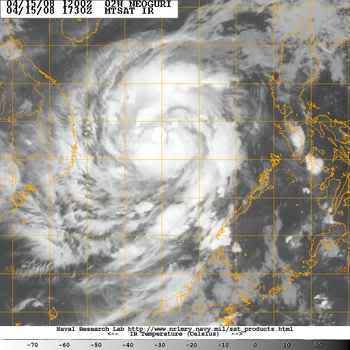
Tropical Storm 02W in de N.W. Pacific.
[ Bericht 8% gewijzigd door #ANONIEM op 15-04-2008 21:25:45 ]
Tropical Storm 02W in de N.W. Pacific.
quote:Tropical storm 02W is forecast to strike the Philippines at about 12:00 GMT on 14 April. Data supplied by the US Navy and Air Force Joint Typhoon Warning Center suggest that the point of landfall will be near 9.2 N, 119.0 E. 02W is expected to bring 1-minute maximum sustained winds to the region of around 64 km/h (40 mph). Wind gusts in the area may be considerably higher.
[ Bericht 8% gewijzigd door #ANONIEM op 15-04-2008 21:25:45 ]
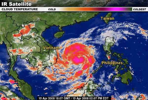
Vietnam gaat geen last krijgen van NEOGURI.
China gaat nu de volle laag krijgen.
Momenteel koerst de cat1 recht op het eiland Hainan af.
China gaat nu de volle laag krijgen.
Momenteel koerst de cat1 recht op het eiland Hainan af.
niet echt gerelateerd aan het 2008 seizoen, maar voor orkaan-junkies wel interessant om te weten:
Professor Kerry Emanuel, de orkaanexpert die in 1985 als een van de eersten een verband legde tussen orkanen en global warming en in 2005 weken voor Katrina een onderzoek publiceerde waarin zijn hypothese "bewezen" werd, heeft nu een nieuw onderzoek gepubliceerd met hele andere conclusies.
De publicatie van Emanuel zelf hier
edit: quote uit de samenvatting toegevoegd
[ Bericht 5% gewijzigd door Ared op 17-04-2008 13:42:44 ]
Professor Kerry Emanuel, de orkaanexpert die in 1985 als een van de eersten een verband legde tussen orkanen en global warming en in 2005 weken voor Katrina een onderzoek publiceerde waarin zijn hypothese "bewezen" werd, heeft nu een nieuw onderzoek gepubliceerd met hele andere conclusies.
quote:A new technique for deriving hurricane climatologies from global data, applied to climate models, indicates that global warming should reduce the global frequency of hurricanes, though their intensity may increase in some locations.
Artikel met wat achtergrondinformatie en samenvatting voor leken in de Houston Chronicles hierquote:It is noteworthy that simulated global tropical cyclone power dissipation increases by more than 60% in simulations driven by NCAR–NCEP reanalysis over the period of 1980–2006, consistent with deductions from best-track data, while global power dissipation increases somewhat more than that over the next 200 yr in simulations driven by climate models undergoing global warming. This suggests either that the greater part of the large global increase in power dissipation over the past 27 yr cannot be ascribed to global warming, or that there is some systematic deficiency in our technique or in global models that leads to the underprediction of the response of tropical cyclones to global warming.
De publicatie van Emanuel zelf hier
edit: quote uit de samenvatting toegevoegd
[ Bericht 5% gewijzigd door Ared op 17-04-2008 13:42:44 ]
Whehe... ben zelf lid van dat blad. En Kerry Emanuels "Atmospheric Convection" ligt op mijn bureau.
Onderzoek naar klimaatvariabiliteit en het effect daarvan op orkanen (en andersom) staat nog ontzettend in de kinderschoenen. Zowel dit verhaal als Emanuels voorgaande verhaal moet dus niet als iets definitiefs worden gezien, maar eerder als een gedachtesprongetje in een discussie. Temeer daar de hoeveelheid data nou niet echt overhoudt; slechts tientallen orkanen per jaar over een halve eeuw met enorme fluctuaties erin, dat maakt het lastig om een trend te ontdekken.
Het pleit overigens voor Emanuel dat hij genuanceerd van mening durft te veranderen.
bron:quote:Waar blijven de orkanen?
Sinds de ramp in New Orleans als gevolg van orkaan Katrina woedt er in Amerika een hevig debat over de vraag of er meer of krachtigere orkanen zullen komen door de opwarming van de aarde. Dat debat is nog onbeslist.
Na de zeer actieve orkaanjaren 2004 en 2005 voorspelden onderzoekers van de Colorado State University (waaronder de beroemde orkaanvoorspeller William Gray) dat ook 2006 en 2007 zeer actieve jaren zouden worden. Die voorspelling kwam echter niet uit. Het was zelfs opvallend rustig.
Met zulke grote verschillen tussen de orkaanseizoenen is het lastig iets te weten te komen over langjarige veranderingen. Volgens de huidige stand van kennis kan het aantal orkanen in een warmer klimaat zowel toe- als afnemen.
Critici wijzen er intussen op dat het vooral de alarmerende artikelen zijn die de aandacht krijgen. Politicoloog Roger Pielke jr constateerde op zijn weblog Prometheus dat een vakpublicatie over orkanen in juli 2007 in twee dagen tijd 79 nieuwsartikelen opleverde, terwijl een artikel over hetzelfde onderwerp in topblad Nature een paar maanden later slechts drie berichten genereerde. Het eerste artikel constateerde dat de opwarming van de aarde meer en krachtiger orkanen zal opleveren; het tweede juist het tegenovergestelde.
Typhoon NEOGURI is nu een categorie 2.
Typhoon Neoguri was nearing its peak strength on April 17, 2008, when the Moderate Resolution Imaging Spectroradiometer (MODIS) on NASA’s Aqua satellite captured this image at 1:30 p.m. local time (05:50 UTC). The first typhoon of the 2008 season in the western Pacific, Neoguri was a relatively weak Category 2 storm. Despite its small size, it was well formed with distinct bands of clouds circling a clear eye. A few hours after this image was taken, Neoguri had winds estimated at 160 kilometers per hour (98 miles per hour or 85 knots) with gusts to 195 km/hr (120 mph or 105 knots). The storm was forecast to weaken as it moved over the South China Sea to eastern Hainan and mainland China. The Joint Typhoon Warning Center predicted that the storm would come ashore over southern China on April 19.
bron:
[ Bericht 48% gewijzigd door #ANONIEM op 17-04-2008 21:20:49 ]
Typhoon Neoguriquote:Typhoon Neoguri is forecast to strike China at about 06:00 GMT on 18 April. Data supplied by the US Navy and Air Force Joint Typhoon Warning Center suggest that the point of landfall will be near 18.6 N, 111.3 E. Neoguri is expected to bring 1-minute maximum sustained winds to the region of around 148 km/h (92 mph). Wind gusts in the area may be considerably higher.

Typhoon Neoguri was nearing its peak strength on April 17, 2008, when the Moderate Resolution Imaging Spectroradiometer (MODIS) on NASA’s Aqua satellite captured this image at 1:30 p.m. local time (05:50 UTC). The first typhoon of the 2008 season in the western Pacific, Neoguri was a relatively weak Category 2 storm. Despite its small size, it was well formed with distinct bands of clouds circling a clear eye. A few hours after this image was taken, Neoguri had winds estimated at 160 kilometers per hour (98 miles per hour or 85 knots) with gusts to 195 km/hr (120 mph or 105 knots). The storm was forecast to weaken as it moved over the South China Sea to eastern Hainan and mainland China. The Joint Typhoon Warning Center predicted that the storm would come ashore over southern China on April 19.
bron:
[ Bericht 48% gewijzigd door #ANONIEM op 17-04-2008 21:20:49 ]
quote:
Niet volgens Wikipedia,quote:Na de zeer actieve orkaanjaren 2004 en 2005 voorspelden onderzoekers van de Colorado State University (waaronder de beroemde orkaanvoorspeller William Gray) dat ook 2006 en 2007 zeer actieve jaren zouden worden. Die voorspelling kwam echter niet uit. Het was zelfs opvallend rustig.
Opvallend rustig is inderdaad niet waar. (2007 dan)quote:
2006 hebben ze totaal verkeerd voorspeld. (dat was wel een rustig seizoen)
De voorspelling van 2007 zag er een stuk beter uit.
China typhoon weakens, 18 fishermen missing
BEIJING, April 19 (Reuters) - Typhoon Neoguri has weakened into a tropical storm after slamming into the southern Chinese island province of Hainan, with 18 fishermen reported missing, state media said on Saturday.
The storm forced the cancellation of 76 flights, caused a power black-out in Hainan's northeastern city of Wenchang, and is now moving into Guangdong province, Xinhua news agency said.
Guangdong flood control authorities said residents in low-lying areas and dangerous houses had all been evacuated to safety, it reported. About 20,000 boats in Guangdong had returned to port.
Though 38 fisherman who had sought shelter in reefs around the Paracel Islands in the South China Sea had been rescued, another 18 from the same group were still missing, Xinhua said.
"All the three boats were damaged and the 38 rescued fishermen swam to reefs and stayed there until being found by a rescue ship," Zhang Jie, vice director of the Hainan Maritime Safety Administration, was quoted as saying.
Chinese scientists have blamed global warming for increasing weather extremes, including devastating typhoons, snow storms, floods and drought, which they say are likely to get worse.
Typhoons, known in the West as hurricanes, are cyclonic storms which draw strength from the warm waters of the South China Sea and regularly target the Philippines, Japan, China, Taiwan and Hong Kong over the summer, sometimes with catastrophic effect.
The typhoon season usually starts in May. (Reporting by Ben Blanchard; Editing by Jeremy Laurence)
reuters
vorig jaar zat er een opmerkelijk groot verschil tussen rekenmethodes. Als je het aantal stormen bekijkt, was het een gemiddeld seizoen. Als je de ACE bekijkt, was het het rustigste seizoen sinds 1977.quote:Op vrijdag 18 april 2008 21:04 schreef aloa het volgende:
Opvallend rustig is inderdaad niet waar. (2007 dan)
2006 hebben ze totaal verkeerd voorspeld. (dat was wel een rustig seizoen)
De voorspelling van 2007 zag er een stuk beter uit.
bron
Een normaal aantal stormen, maar veel die zwak en geen lang leven hadden.quote:Op zaterdag 19 april 2008 12:56 schreef Ared het volgende:
[..]
vorig jaar zat er een opmerkelijk groot verschil tussen rekenmethodes. Als je het aantal stormen bekijkt, was het een gemiddeld seizoen. Als je de ACE bekijkt, was het het rustigste seizoen sinds 1977.
bron
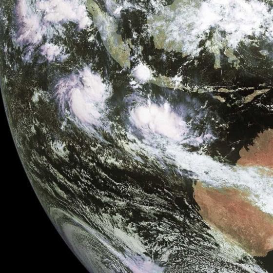
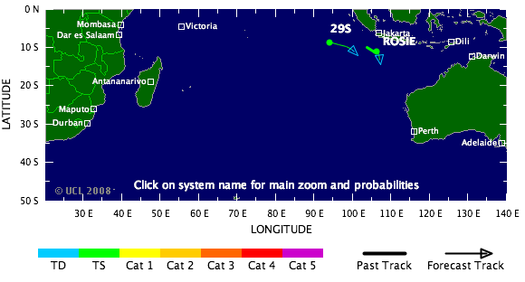
quote:AccuWeather.com sees Atlantic hurricane above normal in '08
AccuWeather.com said Friday it expects warm La Ninca weather conditions to produce a slightly above average number of Atlantic hurricanes in 2008, and increasing the chance for U.S. landfall. "In some areas where hurricanes normally form - the central and eastern tropical Atlantic - ocean water temperatures are near or below normal," said meteorologist Joe Bastardi. "This should limit the number of storms, so we do not expect a near record high number like in the 2005 season. However, considering other factors, the number of storms should be slightly higher than historical averages."

NARGIS gaat waarschijnlijk Birma of Bangladesch treffen.
Het ziet er niet goed uit voor die landen.
kaartje 72uur
Het ziet er niet goed uit voor die landen.
kaartje 72uur

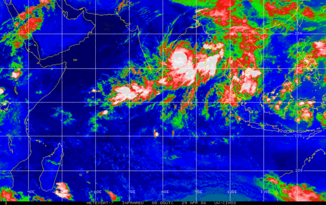

Storm raast over Virginia: minstens 200 gewonden
Bij een zware storm die over de Amerikaanse staat Virginia woedde, zijn gisteren zeker meer dan 200 mensen gewond geraakt. Gouverneur Timothy M. Kaine heeft in sommige delen van de staat de noodtoestand uitgeroepen.
De meeste slachtoffers vielen in Suffolk waar ongeveer 200 mensen gewond raakten. Het Sentara Obici Hospital werd ook getroffen door de storm, maar bleef operationeel. Volgens Dana Woodson, woordvoerster van de stad, zijn vele huizen vernietigd. "Vooral de buurt rond het hospitaal en het stadscentrum zijn zwaar getroffen.
In Colonial Heights, ten zuiden van Richmond, vielen 18 gewonden. Daar blies de storm auto's omver en werden verschillende huizen beschadigd.
http://hln.be/hln/nl/960/(...)s-200-gewonden.dhtml
=============
GOVERNOR KAINE DECLARES STATEWIDE EMERGENCY TO COORDINATE RESPONSE TO SEVERE WEATHER
RICHMOND, Va. — Governor Timothy M. Kaine today declared a state of emergency in the Commonwealth of Virginia, directing state agencies to take all necessary actions to aid in the response to widespread damage from this afternoon’s severe weather.
A declaration of emergency allows the Governor to immediately deploy state personnel, equipment and other emergency response resources, and to coordinate state and local response to the event.
Strong winds and possible tornadoes caused damage in multiple localities. The cities of Colonial Heights and Suffolk were two areas that were severely affected.
Agencies assisting include the Virginia departments of Emergency Management, Marine Resources and Transportation and the Virginia State Police. Other agencies are on standby if needed.
http://www.vaemergency.co(...)808gov_emergency.cfm
Bij een zware storm die over de Amerikaanse staat Virginia woedde, zijn gisteren zeker meer dan 200 mensen gewond geraakt. Gouverneur Timothy M. Kaine heeft in sommige delen van de staat de noodtoestand uitgeroepen.
De meeste slachtoffers vielen in Suffolk waar ongeveer 200 mensen gewond raakten. Het Sentara Obici Hospital werd ook getroffen door de storm, maar bleef operationeel. Volgens Dana Woodson, woordvoerster van de stad, zijn vele huizen vernietigd. "Vooral de buurt rond het hospitaal en het stadscentrum zijn zwaar getroffen.
In Colonial Heights, ten zuiden van Richmond, vielen 18 gewonden. Daar blies de storm auto's omver en werden verschillende huizen beschadigd.


http://hln.be/hln/nl/960/(...)s-200-gewonden.dhtml
=============
GOVERNOR KAINE DECLARES STATEWIDE EMERGENCY TO COORDINATE RESPONSE TO SEVERE WEATHER
RICHMOND, Va. — Governor Timothy M. Kaine today declared a state of emergency in the Commonwealth of Virginia, directing state agencies to take all necessary actions to aid in the response to widespread damage from this afternoon’s severe weather.
A declaration of emergency allows the Governor to immediately deploy state personnel, equipment and other emergency response resources, and to coordinate state and local response to the event.
Strong winds and possible tornadoes caused damage in multiple localities. The cities of Colonial Heights and Suffolk were two areas that were severely affected.
Agencies assisting include the Virginia departments of Emergency Management, Marine Resources and Transportation and the Virginia State Police. Other agencies are on standby if needed.
http://www.vaemergency.co(...)808gov_emergency.cfm
Op zaterdag 15 augustus 2009 23:05 schreef eer-ik het volgende:
Ik vind je sig nogal denigrerend.
Ik vind je sig nogal denigrerend.
quote:Tornado's houden weer huis in VS
WSHINGTON- Tornado's hebben vrijdag in de Amerikaanse staat Arkansas dood en verderf gezaaid. Reddingsdiensten vonden tot dusver drie lijken. Een van de slachtoffers is een meisje van vijftien jaar. Zij lag te slapen toen een ontwortelde boom op haar huis viel.
De meteorologische dienst meldde ook tornado's in Texas, Oklahoma en Kansas.
Bij vele tienduizenden mensen viel de stroom uit. Eerder deze week richtten tornado's al grote schade aan in Virginia. Honderden mensen raakten toen gewond door de 'twisters'.
Life is Music
quote:Teen Dead After Line of Tornadoes Hits Four States
Damage in Midwest as 19 Storms Hit; Storm System Moving East
Nineteen tornadoes swept through four Midwestern states overnight, leaving at least six people dead, according to The Associated Press, and a string of damage to homes and buildings.
weather
A 15-year-old girl in the northwest Arkansas town of Siloam Springs died when a tree fell through the bedroom where she was sleeping, according to The Associated Press.
Police say a 10-year-old boy was rescued from the same room and taken to an area hospital, where he was in good condition and expected to be released.
The line of storms extended through Kansas, Oklahoma, Missouri and Arkansas and is moving toward Illinois, where thunderstorm watches are in effect.
Storm chasers and residents caught video of storms in Kansas and other areas worthy of the "Wizard of Oz."
Related
Hurricane-force winds, hail and heavy rain moving through Missouri left hundreds of Kansas City-area homes and businesses damaged and some destroyed.
No serious injuries have been reported. About 40,000 customers were without power across the metro area, Kansas City Power & Light reported.
Authorities in Oklahoma were assessing damage today after two rounds of severe thunderstorms raked across parts of the state. The first round of storms produced at least two tornadoes Thursday night, causing some damage but no injuries.
The National Weather Service said a trained spotter saw a tornado touch down in central Arkansas as a series of storms began rolling through the state. More than 5,000 customers of Entergy Arkansas lost power. No injuries have been reported.
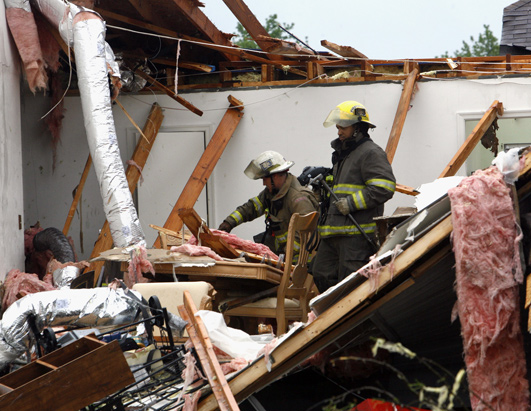
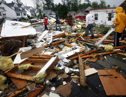
Op zaterdag 15 augustus 2009 23:05 schreef eer-ik het volgende:
Ik vind je sig nogal denigrerend.
Ik vind je sig nogal denigrerend.

Tornado's zijn wat anders als Hurricanes hoor, tornado's hebben een eigen topic 
Cyclone Nargis
On May 1, 2008, Typhoon Nargis hovered over the Bay of Bengal, having become a very severe cyclonic storm. A report issued by the U.S. Navy Joint Typhoon Warning Center at 15:00 UTC (approximately 9:00 p.m. local time) stated that the storm had intensified significantly over the previous six hours and was expected to come ashore in Myanmar (Burma) in the evening of May 2.
The Moderate Resolution Imaging Spectroradiometer (MODIS) on NASA’s Terra satellite acquired this image at 4:40 UTC (10:40 a.m. local time) on May 2, 2008. In this image, the sprawling storm spirals over the bay, between India in the west and Myanmar in the east. Bangladesh lies directly north of the storm. The storm appears to skirt the Andaman Islands in the southeast.
On May 1, Nargis had sustained winds of 90 knots, which would make it a Category 3 hurricane on the Saffir-Simpson hurricane scale, used to rank hurricanes in the United States. According to Voice of America News, even though the storm was predicted to make landfall in Myanmar, the cyclone’s proximity to Bangladesh caused serious concern in that nation as well, where memories lingered of the devastating Tropical Cyclone Sidr, which struck in 2007.
Just north of Nargis, along the coast of Bangladesh, are the Mouths of the Ganges—home to the Sundarbans, a massive mangrove forest. Mangrove forests can provide some protection to coastal regions during severe cyclones
Cyclone Nargis

On May 1, 2008, Typhoon Nargis hovered over the Bay of Bengal, having become a very severe cyclonic storm. A report issued by the U.S. Navy Joint Typhoon Warning Center at 15:00 UTC (approximately 9:00 p.m. local time) stated that the storm had intensified significantly over the previous six hours and was expected to come ashore in Myanmar (Burma) in the evening of May 2.
The Moderate Resolution Imaging Spectroradiometer (MODIS) on NASA’s Terra satellite acquired this image at 4:40 UTC (10:40 a.m. local time) on May 2, 2008. In this image, the sprawling storm spirals over the bay, between India in the west and Myanmar in the east. Bangladesh lies directly north of the storm. The storm appears to skirt the Andaman Islands in the southeast.
On May 1, Nargis had sustained winds of 90 knots, which would make it a Category 3 hurricane on the Saffir-Simpson hurricane scale, used to rank hurricanes in the United States. According to Voice of America News, even though the storm was predicted to make landfall in Myanmar, the cyclone’s proximity to Bangladesh caused serious concern in that nation as well, where memories lingered of the devastating Tropical Cyclone Sidr, which struck in 2007.
Just north of Nargis, along the coast of Bangladesh, are the Mouths of the Ganges—home to the Sundarbans, a massive mangrove forest. Mangrove forests can provide some protection to coastal regions during severe cyclones
Het is een behoorlijk grote catastrophe, die typhoon Nargis, volgens Nu.nl:
quote:Dodental Myanmar loopt op tot 10.000
Uitgegeven: 5 mei 2008 14:38
Laatst gewijzigd: 5 mei 2008 17:23
Het dodental in Myanmar als gevolg van de cycloon Nargis bedraagt volgens voorlopige cijfers van de regering van Myanmar 10.000. Nog eens 3000 mensen worden vermist. Dat zei een diplomaat maandag na een bijeenkomst met de Myanmarese minister van Buitenlandse Zaken Nyan Win.
"Het bevestigde getal is 3934 doden, 41 gewonden en 2879 vermisten in de districten Yangon en Ayeyarwaddy'', meldde de staatszender MRTV. Het officiële dodental is daarmee dramatisch gestegen. Tot nu toe waren 351 doden gemeld.
De cycloon richtte grote verwoestingen aan rond Yangon, de belangrijkste stad van het land. Vijf districten in het zuiden van het land zijn tot rampgebied uitgeroepen. Hier woont bijna de helft van de in totaal 53 miljoen inwoners van Myanmar, het vroegere Birma.
Het dodental zal waarschijnlijk stijgen als reddingswerkers de afgelegen gebieden weten te bereiken.
Verenigde Naties
De Verenigde Naties meldden eerder dat er honderdduizenden mensen dakloos zijn geworden en zonder schoon drinkwater zitten. In grote delen van het rampgebied is de elektriciteit uitgevallen en zitten mensen zonder schoon drinkwater.
Wervelstorm Nargis, met windstoten tot ruim 240 kilometer per uur, trok een spoor van vernielingen door het land. Wegen zijn geblokkeerd door puin en omgewaaide bomen. Bovendien wordt de bewegingsvrijheid van buitenlandse hulporganisaties door het militaire bewind beperkt.
Rellen gevangenis
In de beruchte Insein-gevangenis in Yangon, de belangrijkste stad van Myanmar, zijn zeker 36 gevangenen doodgeschoten tijdens rellen die uitbraken na de verwoestende cycloon Nargis. Dat meldde de doorgaans welingelichte Myanmarese mensenrechtenorganisatie AAPPB maandag vanuit de Thaise hoofdstad Bangkok.
Door de wervelstorm werden de daken van veel cellen afgerukt. Bewakers dreven circa duizend gevangenen daarna samen in een grote hal, waar vuurtjes werden gestookt om het warm te krijgen.
Toen vervolgens door zware rookwolken chaos en paniek uitbraken, openden militairen en agenten het vuur. Zeker zeventig gevangenen zouden gewond zijn geraakt.
Noodhulp
Verscheidene internationale hulporganisaties en de Verenigde Naties praten in Thailand over noodhulp. Thailand zelf heeft een transportvliegtuig met 9 ton voedsel en medicijnen naar het buurland gestuurd.
Europese Commissie
De Europese Commissie heeft maandag 2 miljoen euro voor noodhulp vrijgemaakt voor slachtoffers van de cycloon Nargis in Myanmar.
"Elk uur worden de berichten uit Myanmar grimmiger en grimmiger'', zei EU-commissaris Louis Michel. ,,Dit is een vreselijke ramp die snel en effectieve humanitaire hulp vereist.''
Rode Kruis
Het Nederlandse Rode Kruis opent gironummer 7447 voor de slachtoffers van de cycloon Myanmar in Birma. Dat heeft de organisatie maandag bekendgemaakt.
Huidige trend atmosf. CO2 Mauna Loa: 411 ppm ,10 jaar geleden: 387 ppm , 25 jaar geleden: 358 ppm
Even een eigen topic gegeven --> 10.000 doden in Myanmar na cycloon Nargis
Overigens heb ik net gehoord dat DE topics nu ook in NWS mogen voorkomen en andersom en naast elkaar blijven bestaan. Schroom dus niet om een DE topic dat in NWS staat, ook hier te openen.
Overigens heb ik net gehoord dat DE topics nu ook in NWS mogen voorkomen en andersom en naast elkaar blijven bestaan. Schroom dus niet om een DE topic dat in NWS staat, ook hier te openen.


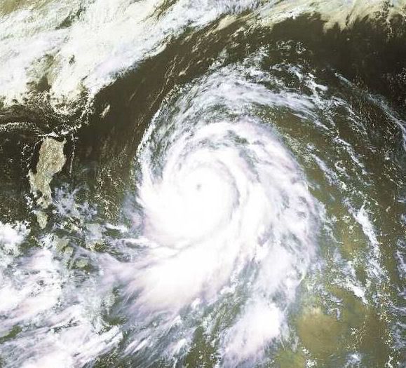
Tropical Storm OPHELIA
Tropical storm Ophelia is forecast to strike the United States as a hurricane at about 12:00 GMT on 14 May. Data supplied by the US National Hurricane Center suggest that the point of landfall will be near 33.7 N, 77.8 W. Ophelia is expected to bring 1-minute maximum sustained winds to the region of around 120 km/h (74 mph). Wind gusts in the area may be considerably higher.
Tropical storm Ophelia is forecast to strike the United States as a hurricane at about 12:00 GMT on 14 May. Data supplied by the US National Hurricane Center suggest that the point of landfall will be near 33.7 N, 77.8 W. Ophelia is expected to bring 1-minute maximum sustained winds to the region of around 120 km/h (74 mph). Wind gusts in the area may be considerably higher.
Dean, Felix, Noel worden niet meer gebruikt als naam voor een toekomstige orkaan.
[ Bericht 3% gewijzigd door #ANONIEM op 14-05-2008 07:58:39 ]
quote:Dean, Felix, Noel retired from hurricane name list
(CNN) -- Three names -- Dean, Felix and Noel -- were permanently retired from the list of Atlantic hurricane names after storms bearing those monikers in 2007 caused damage in the Caribbean, Central America, Mexico and elsewhere, the National Oceanic and Atmospheric Administration said Tuesday.
Members of the organization voted to remove the names during its regional hurricane committee meeting, NOAA said in a written statement. "These names will not be used again because of the widespread destruction caused by these storms."
The list of tropical storm names recycles every six years. In 2013, the three names will be replaced with Dorian, Fernand and Nestor.
Although no storm in 2007 compared to historic hurricanes such as Andrew or Katrina, a storm doesn't have to be major to have its name retired. In 2001, for instance, Tropical Storm Allison, which never reached hurricane status, had its name retired after it dumped more than 3 feet of rain on Houston, Texas.
Since tropical storms were first named in 1953, 70 names have been retired, officials said.
[ Bericht 3% gewijzigd door #ANONIEM op 14-05-2008 07:58:39 ]
Categorie 1 Typhoon HALONG gaat voor overlast zorgen op de filipijnen.
[ Bericht 23% gewijzigd door #ANONIEM op 17-05-2008 11:05:02 ]
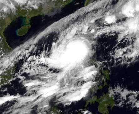
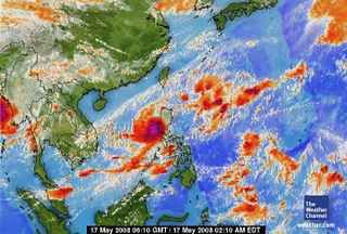
[ Bericht 23% gewijzigd door #ANONIEM op 17-05-2008 11:05:02 ]
quote:Tropische storm Halong bedreigd Filipijnen.
De tropische storm Halong trekt via de Zuid-Chinese zee richting Filipijnen.
Men verwacht dat deze morgenvroeg het noordelijke eiland Luzon zal treffen, wat ongetwijfeld zal leiden tot zware regenval en aan de westkust worden windsnelheden verwacht van meer dan 130km/u.
Weervoorspellers waarschuwen voor een sterke stormvloedkering rond de noordelijke kusten en verwachten op grote schaal overstromingen in de laaggelegen gebieden. Ook in de hoofdstad Manilla wordt zware regenval verwacht.
Volgens de laatste berichten heeft de tropische storm reeds de kusten bereikt en grote delen van het eiland zitten zonder stroomvoorzieningen.
De voorbije week werden er al duizenden mensen geëvacueerd na grootschalige overstromingen in het zuidelijk deel van de Filipijnen.
vwk
12 doden bij noodweer in Filipijnen
Twaalf mensen zijn omgekomen en negen gewond geraakt door zware storm en regen in de Filipijnen.
De tropische storm Halong kwam zaterdag met windsnelheden van 105 kilometer per uur aan land op het noordelijke eiland Luzon.
Vier mensen werden dodelijk getroffen door metalen platen die van huizen werden afgeblazen. Zo'n drieduizend huizen werden vernietigd, bomen werden ontworteld en elektriciteitsmasten werden omver geblazen, waardoor stroom en telefoon uitvielen
De boven land afgezwakte storm zal naar verwachting dinsdag ten zuiden van de Japanse hoofdstad Tokyo langstrekken. Daar wordt vooral veel regen verwacht.
bron:
Bericht uit de [url=http://www.nrc.nl/wetenschap/article1094465.ece/Cycloongevaar_neemt_af_door_opwarmingNRC[/url]
quote:Cycloongevaar neemt af door opwarming
Rotterdam, 20 mei. Het aantal tropische cyclonen boven Caribisch gebied zal onder invloed van het broeikaseffect eerder afnemen dan toenemen. Ook zullen waarschijnlijk minder cyclonen dan vroeger de Amerikaanse kust treffen.
Die verwachting wordt uitgesproken door onderzoekers van de Amerikaanse National Oceanic and Atmospheric Administration (NOAA) in het tijdschrift Nature Geoscience (18 mei). Dat het aantal cyclonen na 1980 is toegenomen en de komende eeuw vermoedelijk juist zal afnemen, komt volgens de onderzoekers doordat de Atlantische Oceaan eerder en sneller opwarmde dan de andere oceanen op aarde.
Dit staat haaks op de populaire opvatting dat de cycloonactiviteit door de huidige opwarming wordt versterkt (zoals ook Al Gore aanneemt). De NOAA-onderzoekers, onder leiding van Thomas Knutson, ontwierpen een regionaal computermodel dat redelijk in staat bleek het voorkomen van cyclonen en zware stormen tussen 1980 en 2006 te reconstrueren. Het aantal cyclonen nam in die periode trendmatig toe, maar vertoonde van jaar tot jaar grote verschillen: soms één cycloon en soms wel elf. Het model wist deze afwisseling na te bootsten.
Werd het nieuwe model ‘geladen’ met klimatologische gegevens zoals die voor de huidige eeuw worden voorzien, dan bleek het aantal cyclonen in het Caribische gebied beduidend af te nemen. Vooral onder de zwakkere cyclonen was dat opvallend. De zeldzame extreem zware cyclonen kunnen juist wat vaker voorkomen. Ook kan de hoeveelheid regen die in en rond cyclonen valt flink toenemen.
Hoe overtuigend het nieuwe model is, wordt niet duidelijk. Het bleek niet in staat de extreem zware cyclonen van de afgelopen 25 jaar te reconstrueren. Maar de uitkomst stemt verrassend overeen met die van een model van Kerry Emanuel, waarover in maart in het Bulletin of the American Meteorological Society is gepubliceerd. Dat voorspelde eveneens minder cyclonen, maar lokaal wel zwaardere. Kerry Emanuel van het MIT in Boston was de man die drie weken vóór orkaan Katrina in Nature (4 augustus 2005) op grond van simpele statistiek voorspelde dat cyclonen steeds zwaarder zouden worden. Die trend dacht hij te hebben waargenomen. Maar de meet-reeks is pijnlijk kort: cyclonen worden pas sinds 1970 door satellieten gesignaleerd. Of de onmiskenbare toename van de laatste 25 jaar een bijzonderheid is en of die samenhangt met het broeikaseffect staat niet vast.
Tropische storm eist drie doden in Nicaragua
In Nicaragua zijn drie mensen om het leven gekomen als gevolg van de tropische storm Alma, de eerste storm van het seizoen in de Oost-Pacific.
Alma kwam vroeger dan verwacht aan land, waardoor de storm niet uitgroeide tot een orkaan. Voor dat geval hadden de autoriteiten in Nicaragua een plan klaar liggen om duizenden mensen te evacueren. Nu bleven de meeste inwoners van het kustgebied bleven gewoon in hun huis. De storm veroorzaakte wel stroomonderbrekingen en overstromingen.
Ook Honduras en El Salvador hebben met overstromingen te kampen door de hevige regenval.
vwk
quote:Atlantic season's 1st tropical storm forms near Belize
Bron: CNN
MIAMI, Florida (CNN) -- Tropical Storm Arthur, the first named storm of the 2008 Atlantic season, formed Saturday near the coast of Belize but was already over land and was expected to weaken later in the day, the U.S. National Hurricane Center said.
As of 2 p.m. ET, the center of Arthur was located about 50 miles (80 km) north-northwest of Belize City, Belize, and about 185 miles (300 km) southwest of Cozumel, Mexico. Its winds were near 40 mph (65 km/hr) with higher gusts.
The storm was moving west-northwest at near 8 mph (13 km/hr), forecasters said. "On this track, the center of circulation will be moving over Yucatan today and early Sunday," the hurricane center said in an advisory.
The storm's strongest winds were northeast and east of the center. Tropical-storm-force winds extended outward up to 260 miles (415 km), mainly to the northeast of the center, forecasters said.
The government of Belize issued a tropical storm warning for the nation's coast, and the government of Mexico issued a tropical storm warning from Cabo Catoche south to the border with Belize.
A tropical storm warning means tropical storm conditions are expected within the warning area -- in this case, within the next six to 12 hours.
The storm was forecast to dump up to 10 inches of rain over Belize, up to 15 inches in isolated areas, the hurricane center said.
The 2008 Atlantic hurricane season begins Sunday.
On Thursday, Tropical Storm Alma, the first one of the year in the eastern Pacific, formed near the west coast of Central America, according to the National Weather Service. The storm was downgraded to a tropical depression and dissipated over the high terrain of Central America.
The federal government's National Oceanic and Atmospheric Administration predicted this month that the Atlantic season would be more active than normal, with up to 16 named storms and up to five major hurricanes of Category 3 or above.
The noted Colorado State University hurricane forecasting team predicted this year that there would be 15 named storms, eight hurricanes and four major hurricanes.
The team calculated a 69 percent chance that at least one major hurricane will make landfall on the U.S. coast.
A survey released this week found that 50 percent of 1,100 adults surveyed in Atlantic and U.S. Gulf Coast states did not have disaster plans or survival kits.
advertisement
"Nearly one in three said they would not prepare their home until a storm is within 24 hours of landfall," Bill Read, director of the National Hurricane Center, said Thursday.
"Now is the time to buy all that stuff," he said upon the release of the survey by polling firm Mason-Dixon.
quote:Eerste Atlantische tropische storm: Arthur
Net ten oosten van Belize is vanmiddag Arthur ontstaan, de eerste tropische storm van het Atlantische orkaanseizoen 2008.
Arthur trekt naar het westnoordwesten, en zal weldra boven land zijn. In afgezwakte vorm zal het dan het Mexicaanse schiereiland Yucatan oversteken. Wanneer het daarna weer boven zee komt, kan het systeem wellicht opnieuw aansterken tot een storm.
vwk
quote:Tropical storm Arthur struck Mexico at about 03:00 GMT on 1 June. Data supplied by the US National Hurricane Center suggest that the point of landfall was near 18.4 N, 89.5 W. Arthur brought 1-minute maximum sustained winds to the region of around 64 km/h (40 mph). Wind gusts in the area may have been considerably higher.
[ Bericht 44% gewijzigd door #ANONIEM op 01-06-2008 14:31:23 ]
Typhoon Nakri
Typhoon Nakri was swirling in the western Pacific Ocean as a powerful Category 4 storm when the Moderate Resolution Imaging Spectroradiometer (MODIS) on NASA’s Terra satellite viewed it on May 29, 2008. The storm had sustained wind speeds of 230 kilometers per hour (145 miles per hour), making it a Super Typhoon, according to the University of Hawaii’s Tropical Storm Information Center.
MODIS shows the storm with a clear, but irregularly shaped eye, which is not expected to hold together, lessening the power of the storm. As of May 29, the Joint Typhoon Warning Center was projecting that the super typhoon would not maintain its strength for long. High-altitude winds were projected to pull the storm apart, and cooler sea surface temperatures were expected in its path. The typhoon was well away from most land, and forecasters were not expecting it to make landfall.
99A.INVEST kon weleens gaan uitgroeien tot Tropische Storm of meer.
De storm is nu 30kts (55km/uur) en bevindt zich in de Indische Oceaan
De storm is nu 30kts (55km/uur) en bevindt zich in de Indische Oceaan
quote:Tyfoon Fengshen bij Fillipijnen
Vandaag raast de Tyfoon Fengshen over de Fillipijnen en er wordt verwacht dat deze zich morgen ook nog boven de Fillipijnen bevindt.
Er werd eerder verwacht dat de Tropische storm Fengshen de Fillipijnen zou vermijden. Maar Fengshen bevindt zich dan toch vandaag boven De Fillipijnen. Deze zorgt daar heftige regenval op de eilanden, die mogelijk tot overstromingen of modderstromen gaan leiden, afhankelijk van hoelang de storm over de eilanden raast.
Inmiddels heeft de storm windsnelheden van 128.7 km/u met windstoten van 152.9 km/u en is dus uitgegroeid tot een Tyfoon van categorie 1. Er wordt verwacht dat de Tyfoon naar een noordoostelijke richting afbuigt richting Japan. Zondagochtend bereikt de Tyfoon mogelijk windsnelheden van 150-177 km/u(categorie 2), maar gelukkig bevindt de Tyfoon zich, volgens de voorspellingen, dan boven zee)Fillipijnen-zee. Wel moeten boten en schepen voor hoge golven oppassen die zijn ontstaan als gevolg van de hoge windsnelheden.

http://weernieuws.weeronl(...)j_fillipijnen/8/2220
Op zaterdag 15 augustus 2009 23:05 schreef eer-ik het volgende:
Ik vind je sig nogal denigrerend.
Ik vind je sig nogal denigrerend.
Tyfoon Filipijnen eist zeker 12 levensquote:Tyfoon Filipijnen eist zeker 12 levens
Op de Filipijnen zijn zeker twaalf doden gevallen bij de doortocht van tyfoon Fengshen. Duizenden mensen zijn op de vlucht geslagen voor overstromingen en aardverschuivingen.
Bij de overstroming van de rivier de Risao, in de zuidelijke provincie Maquindanao, zijn tien mensen verdronken en worden nog acht anderen vermist. In het zuiden van het land zijn twee mensen om het leven gekomen bij aardverschuivingen, ook worden er nog vier personen vermist.
De tyfoon trok gisteren over naar het noordoosten van de Filipijnen met windsnelheden van 140 kilometer per uur. Er zijn meer dan 200.000 mensen geëvacueerd.
Op zaterdag 15 augustus 2009 23:05 schreef eer-ik het volgende:
Ik vind je sig nogal denigrerend.
Ik vind je sig nogal denigrerend.
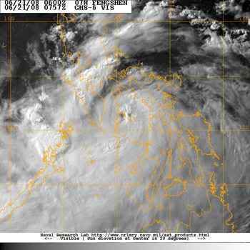
Doden en geëvacueerden door tyfoon Filipijnen
MANILLA - Zeker veertien mensen zijn op de Filipijnen om het leven gekomen door overstromingen en aardverschuivingen na de tyfoon Fensghen.
Tyfoon Filipijnen
In de provincie Iloilo in het midden van het land zijn 30.000 mensen naar de daken van hun huizen gevlucht.
De burgemeester van de stad Iloilo zei dat de mensen zaterdag naar de daken vluchtten, nadat door toedoen van Fensghen een dam was bezweken. Hulpverleners vrezen dat door de overstroming na het breken van de dam veel mensen zijn omgekomen.
Maguindanao
In de zuidelijke provincie Maguindanao trad de rivier Upi buiten zijn oevers. Tien mensen verdronken, aldus een legerwoordvoerder. Acht mensen worden vermist.
Modderlawine
In de zuidelijke stad Cotabato vielen twee doden door een modderlawine. Op het eiland Negros vielen ook twee doden door het noodweer.
nu.nl (c) ANP
Veerboot zinkt voor kust Filipijnen
Voor de kust van de Filipijnen is een veerboot door de orkaan Fengshen in de problemen geraakt. De autoriteiten zeggen dat het schip met ongeveer 700 mensen aan boord bijna is gezonken.
Inmiddels zouden er zeker vier doden uit het water zijn gehaald. Volgens de autoriteiten sprongen de passagiers in rubberboten, nadat de kapitein het schip had verlaten. Door de hoge golven is het voor de kustwacht moeilijk om de veerboot te bereiken.
Door Fengshen, een orkaan van de laagste categorie, zijn op de Filipijnen zeker 59 mensen om het leven gekomen. Fengshen is nu op weg naar Taiwan.
nos
Veerboot zinkt voor Filipijnse kust
Honderden doden door tyfoon Filipijnen
MANILLA - Honderden mensen zijn op de Filipijnen om het leven gekomen door de zware tyfoon Fengshen. Het Rode Kruis van de Aziatische eilandengroep in de Grote Oceaan sprak zondag over 229 bevestigde slachtoffers.
Honderden opvarenden van een gekapseisde veerboot worden vermist. Media spreken over de grootste natuurramp ooit in het land.
De meeste doden op land vielen door overstromingen en aardverschuivingen als gevolg van de wervelwind, die windsnelheden van ruim 170 kilometer bereikte. Omvangrijke gebieden kwamen blank te staan, duizenden huizen werden vernield. Honderdduizenden inwoners raakten dakloos.
Regio
Een functionaris van het Rode Kruis zei dat alleen al in de regio Iloilo op het centraal gelegen eiland Panay 101 mensen zijn omgekomen. Ongeveer 30.000 mensen werden geëvacueerd. Zondag zakte het water. Daardoor konden voertuigen gebieden bereiken die eerder waren overstroomd.
In Iloilo en aangrenzende districten is de elektriciteit uitgevallen. Ook de telefoonverbindingen werken niet meer. Bestuurders zeiden dat het nog wel een week zal duren voordat de bevolking weer over stroom kan beschikken.
Overlevenden
Reddingwerkers hadden tot zondagavond vier overlevenden gevonden van de ramp met de veerboot Princess of the Stars die zaterdag voor de kust van de Filipijnen zonk als gevolg van de tyfoon.
De meesten van de ongeveer zevenhonderd passagiers en 120 bemanningsleden werden nog vermist. Zes lichamen van opvarenden zijn aangespoeld.
Golven
Het schip raakte in de problemen door enorme golven. De Princess of the Stars zond zaterdagavond een noodsignaal uit. Reddingwerkers zagen een gat in de romp van het half gezonken schip.
De Filipijnse president Gloria Arroyo eist opheldering over de omstandigheden waaronder de veerboot uitvoer. Ze wil weten waarom de Princess of the Stars vrijdag uit Manilla mocht vertrekken, toen de tyfoon al delen van het land teisterde.
nu.nl
http://www.nzherald.co.nz/category/story.cfm?c_id=68&objectid=10517717quote:China tornado wrecks 650 homes, kills one
2:45PM Sunday June 22, 2008
BEIJING - A tornado in China tore up 650 houses in just five minutes and damaged nearly 1000, state media said on Sunday, but only one person died.
The tornado touched down in the eastern province of Anhui on Saturday, causing 18.5 million yuan ($3.6 million) in losses.
Forty-five people, including eight seriously wounded, were taken to hospital after the tornado hit in Lingbi county, Xinhua news agency said.
One 76-year-old villager died on the way to hospital.
More than 20,000 people were "affected" by the tornado and 950 were relocated, Xinhua said.
Op zaterdag 15 augustus 2009 23:05 schreef eer-ik het volgende:
Ik vind je sig nogal denigrerend.
Ik vind je sig nogal denigrerend.

Een tornado is iets anders dan een orkaan.quote:Op maandag 23 juni 2008 11:50 schreef OA het volgende:
[..]
http://www.nzherald.co.nz/category/story.cfm?c_id=68&objectid=10517717
En dit is tenslotte het orkanen topic.

Heb ik vaker fout gedaan...quote:Op maandag 23 juni 2008 18:07 schreef aloa het volgende:
[..]
Een tornado is iets anders dan een orkaan.
En dit is tenslotte het orkanen topic.
Op zaterdag 15 augustus 2009 23:05 schreef eer-ik het volgende:
Ik vind je sig nogal denigrerend.
Ik vind je sig nogal denigrerend.
PHILIPPINES: Typhoon Fengshen death toll rises to 224
reuters
MANILA, 23 June 2008 (IRIN) - Typhoon Fengshen moved out of the Philippines on 23 June towards China, leaving at least 224 dead, hundreds missing and thousands homeless, according to the Philippine National Red Cross and Office of Civil Defence. Heavy rains and winds of up to 195km an hour caused landslides, flash floods and storm surges.
The number of fatalities exludes the passengers and crew of the MV Princess of Stars, which sank off Romblon Island in the Visayas. The ferry, bound for Cebu Island, Central Visayas, was carrying more than 800 people. Four bodies were washed ashore, while about 30 survivors were found. The rest remain unaccounted for, according to National Disaster Coordinating Council (NDCC) spokesman Anthony Golez.
"Our priority now is the relief and rescue operations for the victims of the typhoon, including those who are in the sunken ship," Golez told IRIN.
The island region of Western Visayas was worst hit and is the priority area for relief and rescue operations, Golez said.
"Last Saturday and Sunday [21 and 22 June], the province was one big sea," said Governor Sally Perez of Antique province in Western Visayas, where 34 people were found dead and 70 are still missing. Perez is the chief of the provincial disaster coordinating council.
In other areas, the water was reportedly as high as a double-storey house. In Iloilo, Western Visayas, about 30,000 residents reportedly climbed on to rooftops to flee the rushing water from an overflowing dam.
Aerial assessment
Golez said the government flew two C-130 planes to the area on 23 June to assess the damage and provide relief supplies. The strong winds had prevented the earlier delivery of goods by helicopter. Authorities say that only after the aerial assessment would they know the full extent of the damage.
"The priority is feeding our hungry people," Perez told IRIN. She added that they did not have sufficient clothing or medicines.
"We need drinking water, rice, noodles, blankets, and clothes," added Iloilo Congressman Raul Gonzalez Jr. "At the height of the typhoon on Saturday [21 June], the local government began distributing rice but it was spoiled by the torrential rain before it could be delivered by truck. Even the National Food Authority warehouse [where government-distributed rice is kept] was under water."
Many other areas of the country were under water. Typhoon Fengshen passed over central Luzon - the "rice granary" of the Philippines - on its way out of the country. Several provinces in the region were still submerged on 23 June, and fatal flash floods and landslides were reported in several parts of Mindanao on 21 June.
The Department of Agriculture reported that damage to crops had reached nearly P555 million (US$12.6 million), affecting an estimated 246,000 hectares of rice farms.
Antique province alone estimated a loss of P100 million, said Perez. "About 2,000 hectares of agricultural land is now unusable," she said.
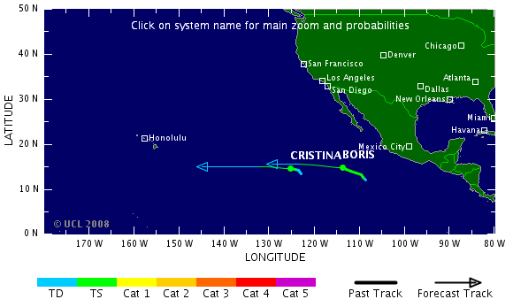
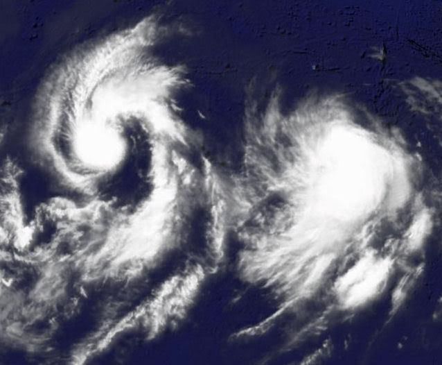
Boris & Cristina
In the eastern Pacific, Tropical Storm Cristina (40 mph) is weakening and Tropical Storm Boris (70 mph) may briefly flare to minimal hurricane strength before beginning to weaken as they both continue to move westward far away from land.
Boris is located about 735 miles southwest of Cabo San Lucas, Mexico; Cristina is centered roughly 1345 miles west-southwest of Cabo San Lucas.
Both storms are forecast to weaken as they edge westward.
A broad area of disturbed weather several hundred miles south of the Gulf of Tehuantepec could develop slowly as it moves west-northwestward over the next several days.
In the Atlantic Basin, there are no areas of concern.
bron
Douglas off western Mexican Coast
Boris
Boris has weakened back to a tropical storm tonight. Boris is centered about 1235 miles west-southwest of Cabo San Lucas, Mexico, and is forecast to move slowly westward and weaken with time.
Meanwhile, Tropical Storm Douglas (40 mph) has been christened off the west coast of Mexico. The storm, moving toward the northwest, is located about 345 miles south-southeast of Cabo San Lucas, and is forecast to strengthen slowly over the next 24 hours.
No warnings or watches have been posted along the Mexican west coast, but heavy rain associated with Douglas could affect areas between Lazaro Cardenas and Puerto Vallarta tonight.
The forecast calls for Douglas to parallel the coast as it moves up toward the Baja. All interests in the Southern Baja and mariners off the west coast will need to monitor Douglas closely the next several days.
In the eastern Atlantic, a well defined low pressure center is located about 330 miles southeast of the Cape Verde Islands and is swirling toward the west. Environmental conditions appear favorable for slow development of this disturbance, and it could become a tropical depression within the next day or two as it continues westward. Development in this area is rare, but not unprecedented, at this time of year.
Boris

Boris has weakened back to a tropical storm tonight. Boris is centered about 1235 miles west-southwest of Cabo San Lucas, Mexico, and is forecast to move slowly westward and weaken with time.
Meanwhile, Tropical Storm Douglas (40 mph) has been christened off the west coast of Mexico. The storm, moving toward the northwest, is located about 345 miles south-southeast of Cabo San Lucas, and is forecast to strengthen slowly over the next 24 hours.
No warnings or watches have been posted along the Mexican west coast, but heavy rain associated with Douglas could affect areas between Lazaro Cardenas and Puerto Vallarta tonight.
The forecast calls for Douglas to parallel the coast as it moves up toward the Baja. All interests in the Southern Baja and mariners off the west coast will need to monitor Douglas closely the next several days.
In the eastern Atlantic, a well defined low pressure center is located about 330 miles southeast of the Cape Verde Islands and is swirling toward the west. Environmental conditions appear favorable for slow development of this disturbance, and it could become a tropical depression within the next day or two as it continues westward. Development in this area is rare, but not unprecedented, at this time of year.
Toekomstig Tropical Storm Bertha in de Atlantische Oceaan.
T.D. 2 forms in the Atlantic
Tropical Depression 2 (winds 35 mph) has formed 250 miles SSE of the Cape Verde Islands in the far eastern Atlantic. It is forecast to become Tropical Storm Bertha later today as it moves toward the west-northwest.
Also in the Atlantic, an area of showers and thunderstorms is moving through the Windward Islands with some gusty winds and locally heavy rain.
Meanwhile in the eastern Pacific, minimal Tropical Storm Douglas (40 mph), located about 230 miles south of Cabo San Lucas, will likely weaken to a tropical depression later today as its movement turns more westerly.
Tropical Storm Boris, also in the eastern Pacific and located 1270 miles west-southwest of Cabo San Lucas, Mexico, will continue to weaken and could become a tropical depression by tonight as its movement turns west-southwestward.
Na een tijdje nauwelijks tropische stormen of orkanen, begint het ineens tot leven te komen.
Tropische Storm Bertha bij de Kaapverdische eilanden
Tropische Storm Bertha bij de Kaapverdische eilanden
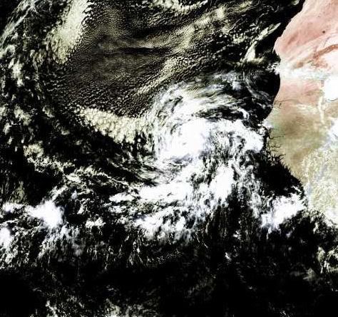

Komt er nog een herhaling vanquote:Op vrijdag 4 juli 2008 23:00 schreef Frutsel het volgende:
Gisteravond indrukwekkende docu over Nargis op National Geo
Orkaan Bertha is een feit (cat. 1). Waarschijnlijk komt ze niet aan land. Ben benieuwd wat we dit jaar te verwerken krijgen aan orkanen (woon in Cancun en werk op de Caribische eilanden)  Eén ding weet ik wel, ik ga NIET in mijn huis schuilen als er een orkaan komt. Ik woon in een hoog, erg smal gebouw zonder buren naast me (alleen boven en onder). Dat vertrouw ik niet, dus ik heb al afgesproken met een vriendin dat ik bij haar en haar familie ga schuilen

Bertha is een categorie3 geworden.
"Major" Hurricane Bertha
Hurricane Bertha (120 mph) intensified rapidly on Monday.
Bertha, as of 5 a.m. EDT, was centered about 1035 miles SE of Bermuda and moving toward the NW at 10 mph.
The hurricane may grow in size as it moves to higher latitudes.
It still appears as if Bertha will eventually take a more northerly course and miss the East Coast of the U.S. Bermuda, however, could be threatened. Residents of the island are advised to pay close attention to the hurricane's progress.
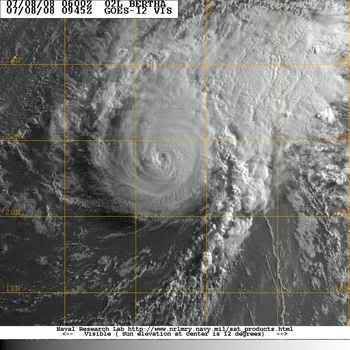
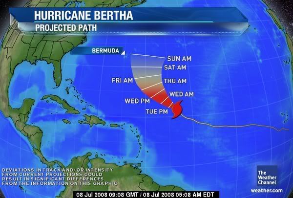
Wow. Dat was nou niet echt voorzien, geloof ik. Bewijst maar weer dat we nog geen donder van die dingen snappen.
Two named storms
Category 1 Hurricane Bertha (winds of 80 mph) is centered about 215 miles southeast of Bermuda, creeping northward at around 2 miles per hour. This very slow movement will continue into Monday. Then Bertha's track should gradually veer northeastward and then eastward with steady weakening.
Bermuda is experiencing high surf on the order of 16 to 22 feet along south and southeast facing beaches. Increased surf is also impacting the East Coast of the United States, especially now from the Outer Banks northward, with 3 to 7 foot waves. Dangerous rip currents are also occurring.
In the eastern Pacific, Tropical Storm Elida has formed, located 270 miles south-southeast of Acapulco, Mexico. It is currently moving west northwest, away for the western Mexico Coast; little impact to land is expected.
An area of low pressure was also located about 200 miles south of Cabo San Lucas, Mexico. It is possible this could develop into a tropical depression, as it moves slowly off to the west.
Bertha weakened from a hurricane to a tropical storm Sunday as it hovered near Bermuda. Forecasters say it might still deal a glancing blow to the Atlantic island.
Bertha's outer bands were expected to brush the island in the coming days.
Over the weekend, most tourists chose to hang out in pools and walk along the beach instead of battle the storm-whipped surf and rip currents along Bermuda's southern coast. Signs were posted announcing that beaches are closed.
"You can go out and swim if you like, but lifeguards will not come out and get you," said Darnell Joell, a bartender at Coco Reef resort.
Lifeguards at Horseshoe Beach blocked the shoreline with bright red tape and turned tourists away. Many lingered, however, taking pictures of the crashing waves.
The U.S. National Hurricane Center said the storm's maximum sustained winds decreased to near 65 miles per hour. Bertha was centered about about 180 miles southeast of Bermuda.
The center said Bertha was moving northwest at about 2 miles per hour. The center of the storm is expected to pass slowly not far to the southeast and east of Bermuda, dumping 2-4 inches of rain on the island. The center's hurricane tracking map showed Bertha sideswiping Bermuda on Monday, a day later than earlier forecasts.
Many tourists were largely unconcerned.
"It's not really going to hit that hard," said Eilif Kenny, 21, who was visiting from Ireland. "If it was ... I'd be under the bed."
Bertha became the Atlantic season's first hurricane on July 7 and has vacillated between a Category 1 and 2 storm.
Meanwhile, Tropical Storm Elida swirled off Mexico's Pacific coast, about 250 miles southwest of Acapulco.
The hurricane center said Elida was headed farther out to sea. It had sustained winds of nearly 65 mph on Sunday morning and was traveling west-northwest at 16 mph.
cnn

Hurricane Bertha
Tropical Storm Bertha swept past Bermuda on July 14, 2008. The storm system had fallen from hurricane strength, but it still packed winds of 100 kilometers per hour (55 miles per hour) around the storm center. The island of Bermuda is no stranger to severe storms, and had battened down in preparation. There were widespread power outages, but no serious damage or injuries were reported, according to the Associated Press on July 15. Rip tides and surf were unusually strong not only in Bermuda, but along much of the east coast of the United States, due to the winds and waves from the storm system.
This natural-color satellite image, obtained by the Moderate Resolution Imaging Spectroradiometer (MODIS) on NASA’s Terra satellite shows Tropical Storm Bertha as it appeared at 12:05 p.m. local time (15:05 UTC) on July 14, 2008. The storm system shows the hallmark spiral shape of a tropical storm system and remnants of a central eye, but its appearance was more ragged than a well-formed hurricane. As of July 15, forecasters at the National Hurricane Center were anticipating that the storm system would move away from Bermuda and rebuild in strength slightly to reach Category 1 hurricane status once again.
Momenteel zijn er 4 systemen aktief, waarvan Tropical cyclone KALMAEGI het meeste gevaar oplevert.
Kans is groot dat er zich eerdaags weer een storm in de Atlantische Oceaan ontwikkeld.
Kans is groot dat er zich eerdaags weer een storm in de Atlantische Oceaan ontwikkeld.
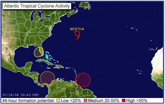
Ligt het aan mij of lijkt het ook ten zuiden van Cuba en zuidwesten van de Dominicaanse republiek te broeien?
Het kon inderdaad weleens druk gaan worden in de Caribbean.quote:Op donderdag 17 juli 2008 09:48 schreef Frutsel het volgende:
[ afbeelding ]
Ligt het aan mij of lijkt het ook ten zuiden van Cuba en zuidwesten van de Dominicaanse republiek te broeien?

Fausto en Elida gaan langs elkaar, die moeten gewoon mergen tot een 'superstorm'
BTW: Onderste lijn is Fausto, bovenste is Elida
Bertha schrijft geschiedenis
De tropische storm Bertha gaat de geschiedenis in als het langstlevende systeem op de Atlantische Oceaan in juli.
Bertha die op 3 juli ontstond voor de kust van Afrika leeft alweer 14 dagen en versloeg daarmee “storm nummer 2” uit 1916. Dit systeem leefde 12 dagen. Het systeem trekt naar IJsland, waar het de komende week voor storm zal zorgen. Tegelijkertijd wordt er dan warmte uit het zuiden onze richting opgestuwd.
Bertha heeft toch nog indirect voor één dode gezorgd. Langs de oostkust van de Verenigde Staten kwamen gevaarlijke stromingen voor, waarbij één persoon verdronk.
vwk
Die dikke Bertha gaat ons weer nog behoorlijk op de schop gooien volgende weekquote:Op donderdag 17 juli 2008 22:33 schreef aloa het volgende:
Bertha schrijft geschiedenis
De tropische storm Bertha gaat de geschiedenis in als het langstlevende systeem op de Atlantische Oceaan in juli.
Bertha die op 3 juli ontstond voor de kust van Afrika leeft alweer 14 dagen en versloeg daarmee “storm nummer 2” uit 1916. Dit systeem leefde 12 dagen. Het systeem trekt naar IJsland, waar het de komende week voor storm zal zorgen. Tegelijkertijd wordt er dan warmte uit het zuiden onze richting opgestuwd.
Bertha heeft toch nog indirect voor één dode gezorgd. Langs de oostkust van de Verenigde Staten kwamen gevaarlijke stromingen voor, waarbij één persoon verdronk.
vwk
* I intend to live forever, so far so good! *
Hurricane Isabel heeft het langer volgehouden dacht ik toch...
Drie weken
http://www.hurricaneville.com/isabel.html
Drie weken
http://www.hurricaneville.com/isabel.html
A tropical storm lashed Taiwan on Friday, killing at least seven people, an emergency official told CNN.
Another six were hurt and six more were missing, according to the official at the island's Central Response Center.
The missing included a husband and wife who were swept away by fast-rising creek water, officials said.
Tropical Storm Kalmaegi dumped heavy rain on central and southern Taiwan, causing problems in places such as Taichung, a city in central Taiwan.
The eye of the storm left Taiwan on Friday, but storm clouds lingered, and forecasters warned of heavy rain and the possibility of mudslides in central and southern regions of the island, particularly in mountainous areas.
Flooding was reported in many low-lying areas, particularly in southern Taiwan, according to the island's Central News Agency. It published a photo of knee-deep water on a highway in Kaohsiung County. Flood waters rose to the height of two stories in one city, officials said.
Officials said that water was cut off from more than 650,000 households because of flooding in Tainan county, also in southern Taiwan, The Associated Press reported. Watch how high the flooding reaches »
Forecasters expect the storm to hit coastal areas of southeastern China late Friday, prompting authorities to plan for possible flooding in Zhejiang and Fujian provinces, according to China's state-run Xinhua news agency.
Boats and ships from those provinces have been ordered back to port, the agency said.
CHARLESTON, S.C. — A storm off the Southeast coast that sent bands of rain into Georgia and South Carolina developed into a tropical depression late Friday night, the National Hurricane Center said.
The hurricane center issued a tropical storm warning from South Santee River, S.C., to the North Carolina/Virginia border, including Pamlico Sound. That means tropical storm conditions are expected within the warning area within the next 24 hours.
A tropical storm watch was issued from north of Edisto Beach, S.C., to South Santee River, and from north of Cape Hatteras to Oregon Inlet, meaning tropical storm conditions are possible within the watch area, generally within 36 hours.
At 11 p.m., the center of the tropical depression about 45 miles southeast of Charleston and about 295 miles southwest of Cape Hatteras. Movement was to the northeast at about 5 mph, and the hurricane center expected the storm to continue that movement for the next two days, keeping the storm close to the coast.
Maximum sustained winds were near 30 mph with higher gusts. Forecasters called for some strengthening in the next 24 hours, and said the depression could become a tropical storm on Saturday.
Meteorologist Jonathan Lamb of the National Weather Service in Charleston said most of the rain remained offshore and, even if the storm deepened, it would not cause too many problems.
"Even if it did develop and stayed off the coast, the impacts on the Charleston and Savannah areas would be relatively low," he said. "It wouldn't be anything near a hurricane or anything like that."
He said the storm could bring occasional showers and thundershowers, some heavy at times.
A tropical depression has winds of 38 mph or less. It becomes a tropical storm with winds sustained at 39 mph.
If the system develops into a tropical storm, it would be named Cristobal, the third named in the 2008 Atlantic Hurricane season.
Zo, over een weekje zit ik in het vliegtuig naar de Filippijnen.... Midden in Typhoonseizoen (wat een timing!!!)
Hopelijk gebeurt er niets, maar blijf er een maand.
Héél misschien ooggetuigeverslag... als ik zin heb om een internetcafé in te duiken én als er wat gebeurd.
links:
www.typhoon2000.com
www.pagasa.dost.gov.ph
Hopelijk gebeurt er niets, maar blijf er een maand.
Héél misschien ooggetuigeverslag... als ik zin heb om een internetcafé in te duiken én als er wat gebeurd.
links:
www.typhoon2000.com
www.pagasa.dost.gov.ph
Ik ben een eckte rapnegert
Mooie beelden van Fausto trouwens:
http://satelliet.weeronline.nl/midden_amerika/mexico/97
[ Bericht 28% gewijzigd door Gummibeer79 op 20-07-2008 15:33:28 ]
http://satelliet.weeronline.nl/midden_amerika/mexico/97
[ Bericht 28% gewijzigd door Gummibeer79 op 20-07-2008 15:33:28 ]
Ik ben een eckte rapnegert
MIAMI — Tropical Storm Dolly has formed in the western Caribbean sea.
The National Hurricane center issued a tropical storm warning Sunday for the Yucatan Peninsula of Mexico from the border with Belize to Campeche (kam-PAY'-chay), Mexico.
At 11:45 a.m. eastern time, the center of the storm was about 270 miles east of Chetumal (chay-too-MAHL'), Mexico, and 230 miles southeast of Cozumel. Maximum sustained winds are about 45 miles per hour.
Dolly is moving toward the northeast at 17 miles per hour, and forecasters expect it to continue moving in this direction for the next two days.
This is the fourth tropical storm of the Atlantic hurricane season, which runs through the end of November.
Tropical storm Dolly, daar zit ik momenteel middenin Kwam ik vanochtend achter  Had net al een berichtje gezet in het Mexico topic in TRV, zal het ff copy pasten.
Hahaha Ik ben gisteren met een vriendin naar het strand geweest in een dorpje een half uur van Cancun (Puerto Morelos) en het begon ineens heel hard te waaien, om een uur of 3 's middags. Daarna begon het te stortregenen. Hmmm gezellig dagje strand. Wij weer naar Cancun gereden, beetje geshopt in een van de vele shoppingmalls, en om 6 uur 's avonds was ik thuis. Het bleef maar stortregenen. Ik zat gisteravond nog heerlijk een boek te lezen, had mijn raam open, en het begon me ineens toch te waaien! Hmm, dacht ik, ik doe het raam maar dicht.
Ik naar bed, paar keer wakker geworden van de regen, regen en nog eens regen, vanochtend tussen 2 buien door naar mijn werk gegaan. Nu zit ik op kantoor, en heeft iedereen het over de tropische storm Ooooh, dus daarom waaide het zo hard gisteravond
Trouwens, dat waaien duurde niet lang (uurtje of 3). Wat we nu hebben is regen, regen, regen. Maar het waait niet meer Tropische storm klinkt heel ernstig, dit is vergelijkbaar met een dagje hondeweer in Nederland, alleen dan een stuk warmer Alles functioneert nog gewoon hoor, de bussen rijden, de winkels zijn open, en ik zit op mijn werk Over een dag zal het wel weer blauwe lucht en zon zijn.
Hahaha
Ik naar bed, paar keer wakker geworden van de regen, regen en nog eens regen, vanochtend tussen 2 buien door naar mijn werk gegaan. Nu zit ik op kantoor, en heeft iedereen het over de tropische storm Ooooh, dus daarom waaide het zo hard gisteravond
Trouwens, dat waaien duurde niet lang (uurtje of 3). Wat we nu hebben is regen, regen, regen. Maar het waait niet meer
Best een groot 'stormpje'...quote:Hurricane Dolly aims for Texas
MIAMI, Florida (CNN) -- A hurricane watch has been issued Monday for the Texas coast from Brownsville northward to Port O'Connor as Tropical Storm Dolly heads northwest and moves over the warm waters of the Gulf of Mexico.
Tropical Storm Dolly, here at 5:15 a.m. ET Monday, could become a hurricane by Tuesday, forecasters say.
1 of 2 A hurricane watch means that hurricane conditions are possible within the watch area within the next day and a half.
A tropical storm watch also has been issued along the Texas coast from north of Port O'Connor to San Luis Pass. A tropical storm watch means that tropical storm conditions are possible within the watch area.
At 11 a.m. ET Monday, the storm was about 55 miles (about 90 kilometers) north-northeast of Progreso, Mexico. The National Hurricane Center said the storm is moving west-northwest at about 18 mph (30 kph). Maximum sustained winds are close to 50 mph (85 kph).
On this track, Dolly will be approaching the coast of the western Gulf of Mexico by Wednesday.
By Tuesday, Dolly could become a hurricane, the hurricane center reported.
The government of Mexico has issued a hurricane watch from Rio San Fernando Mexico northward to the U.S. border and a tropical storm watch from La Pecan Mexico northward to Rio San Fernando.
A tropical storm warning also remains in effect from the Mexico-Belize border northward to the city of Campeche on the opposite side of the Yucatan Peninsula. The tourist resort of Cancun is included in the warning. Two to four inches of rain are expected along the northern part of the peninsula.
Meanwhile, forecasters dropped warnings for the North Carolina coast after Tropical Storm Cristobal began turning away from land. Storm warnings that had been posted for the North Carolina coast were lifted Sunday
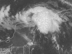
Kom op met die foto's... we want LIVE REPORTS!quote:Op maandag 21 juli 2008 19:05 schreef Vogue het volgende:
Tropical storm Dolly, daar zit ik momenteel middenin
Hahaha
Ik naar bed, paar keer wakker geworden van de regen, regen en nog eens regen, vanochtend tussen 2 buien door naar mijn werk gegaan. Nu zit ik op kantoor, en heeft iedereen het over de tropische storm Ooooh, dus daarom waaide het zo hard gisteravond
Trouwens, dat waaien duurde niet lang (uurtje of 3). Wat we nu hebben is regen, regen, regen. Maar het waait niet meer
http://www.fd.nl/csFdArti(...)ropische_storm_Dollyquote:Oliereus Shell evacueert honderden personeelsleden uit de westelijke Golf van Mexico in verband met de tropische storm Dolly. Dolly bereikt naar verwachting woensdag het vaste land in het zuiden van Texas.
Zondag werden al 125 mensen door Shell weggehaald. Maandag wil het olieconcern nog eens 60 werknemers evacueren. De productie zal waarschijnlijk niet worden geraakt, aldus Shell.
Dolly is de eerste tropische storm die de golf aandoet in het Atlantische orkaanseizoen van 2008. Volgens projecties van het U.S. National Hurricane Center passeert de storm langs het schiereiland Yucatan, vlak bij Mexico's grootste olieveld, waar Petroleos Mexicanos dagelijks ongeveer 1 miljoen vaten ruwe olie per dag produceert.
Eerste orkaan van 2008 boven Atlantische Oceaan 7 juli 2008
Een overzicht van het Atlantisch orkaanseizoen 2007 (wikipedia)
Behalve het gevaar voor de olieproductie, bedreigt Dolly ook een aantal belangrijke toeristische bestemmingen in het gebied, zoals de stad Cancún en het eiland Cozumel. De autoriteiten in de Mexicaanse deelstaat Quintana Roo raden mensen in een kuststrook van ongeveer honderd kilometer aan de regio te verlaten.
In Guatemala zorgde Dolly de afgelopen dagen voor zware regenval en aardverschuivingen. Volgens meteorologen trekt de storm in de loop van de week aan tot orkaankracht.
[ Bericht 5% gewijzigd door Frutsel op 22-07-2008 11:34:08 ]
I Ask for so Little. Just Fear Me, Love Me, Do as I Say, and I Will Be Your Slave.
User van NWS zei: Maak van internet een schoner riool! YES WE CAN!
User van NWS zei: Maak van internet een schoner riool! YES WE CAN!
2008 is behoorlijk heftig begonnen, vooral in het Atlantisch gebied. Staatje van ACE (cumulatieve orkaan energie):
Basin - 2008 ACE - CLIMO ACE - % of NORM
Western Pacific - 67.0 - 63.4 - 104%
Eastern Pacific - 30.1 - 31.9 - 94%
North Atlantic - 31.8 - 5.1 - 622%
North Indian - 14 - 6.4 - 219%
Northern Hemisphere - 143.3 - 106.8 - 134%
Southern Hemisphere - 225 - 236 - 95%
bron
Pacific redelijk normaal, Indische Oceaan flink boven gemiddeld (o.a. Nargis) en Noord Atlantisch op 622% van wat gebruikelijk is voor deze tijd van het jaar!
Kijken we even naar het vooruitzicht van de specialisten uit mei, zien we het volgende:
Hm, op dit tempo gaan we die voorspelling volledig om zeep helpen, en de echt actieve maanden moeten volgens dit rapport nog komen. Blijkt maar weer hoe moeilijk het is om dit goed te voorspellen (of hoe weinig we er van snappen...)
Basin - 2008 ACE - CLIMO ACE - % of NORM
Western Pacific - 67.0 - 63.4 - 104%
Eastern Pacific - 30.1 - 31.9 - 94%
North Atlantic - 31.8 - 5.1 - 622%
North Indian - 14 - 6.4 - 219%
Northern Hemisphere - 143.3 - 106.8 - 134%
Southern Hemisphere - 225 - 236 - 95%
bron
Pacific redelijk normaal, Indische Oceaan flink boven gemiddeld (o.a. Nargis) en Noord Atlantisch op 622% van wat gebruikelijk is voor deze tijd van het jaar!
Kijken we even naar het vooruitzicht van de specialisten uit mei, zien we het volgende:
bronquote:Allowing for uncertainties, we estimate a 60%-70% chance of occurrence for each of the following ranges of activity:
12-16 named storms,
6-9 Hurricanes,
2-5 Major Hurricanes,
An ACE range 100%-210% of the median
These likely ranges have been observed in about two-thirds of past seasons having similar climate conditions to those expected this year. They do not represent the total ranges of activity seen in those past seasons.
Most of the 2008 activity is expected to take place during August through October (ASO), the peak months of the Atlantic hurricane season.
Hm, op dit tempo gaan we die voorspelling volledig om zeep helpen, en de echt actieve maanden moeten volgens dit rapport nog komen. Blijkt maar weer hoe moeilijk het is om dit goed te voorspellen (of hoe weinig we er van snappen...)
quote:Texas en Mexico maken zich op voor orkaan Dolly
BROWNSVILLE - Honderduizenden Texanen en Mexicanen maken zich op voor de orkaan Dolly. De autoriteiten in Mexico hebben meer dan 20.000 mensen geëvacueerd.
De zware storm komt naar verwachting rond het middaguur aan in het grensgebied tussen de Verenigde Staten en Mexico.
Dolly is een orkaan van de eerste en minst zware categorie en geldt als zwak. Meteorologen zijn evenwel bang voor zware regenval tot 25 centimeter. Dat kan overstromingen veroorzaken.
Boortorens
Een aantal oliemaatschappijen, waaronder Shell, heeft personeel van boortorens in de Golf van Mexico gehaald. De Amerikaanse luchtmacht verplaatst meer dan honderd toestellen van een militair vliegveld naar bases elders in Texas en New Mexico.
Dolly is de tweede orkaan van dit jaar. Het orkanenseizoen (juni tot eind november) wordt volgens voorspellers actiever dan gemiddeld.
quote:Affected Population
Up to 1.57 million people can be affected by wind speeds of hurricane strength or above. In addition, 16.28 thousand people are living in coastal areas below 5m and can therefore be affected by storm surge.
Affected Country (provinces) (population)
Mexico (Tamaulipas) (2272724), United States (Texas) (17677900).
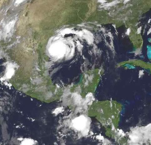
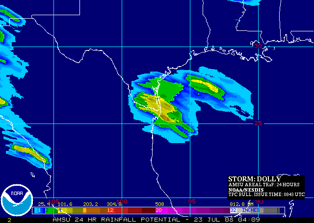
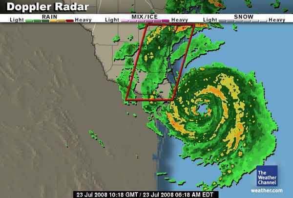
quote:Hurricane Dolly intensifies as landfall nears
Hurricane Dolly has strengthened further early this morning and now is packing maximum sustained winds of 85 mph; a formidable category one hurricane.
With its slow movement over the Gulf of Mexico, Hurricane Dolly remains over the warm waters allowing it to further intensify this morning. Attaining category two status before landfall is not out of the question. It is expected to make landfall along the northern Mexico or southern Texas Gulf Coast by midday.
As of 4 a.m. CDT, the center of Hurricane Dolly was located about 65 miles east-southeast of Brownsville, Texas. Dolly is sluggishly moving toward the northwest at just 9 mph. The storm's pressure, measured by the Air Force Hurricane Hunter reconnaissance plane, has now fallen to 976 mb.
Hurricane warnings have been issued from Rio San Fernando in Mexico northward to Corpus Christi, Texas. Tropical storm warnings surround the hurricane warning area, with tropical storm warnings in effect in Mexico between Le Pesca and Rio San Fernando (where a hurricane watch is also in effect), and between Corpus Christi and San Luis Pass in Texas.
The outer rain bands of Hurricane Dolly are now rotating onshore along the far South Texas coastline. This is just the beginning and conditions will only continue to deteriorate this morning as Dolly's center of circulation approaches.
Nasty squalls of tropical downpours and tropical storm-force winds have already begun to impact South Texas. The eyewall of Hurricane Dolly, where the most intense winds and rainfall is located, is only just 50 to 60 miles away from the shoreline.
Hurricane-force winds and lashing rainfall will be experienced by the Brownsville area, including S. Padre Island, and in neighboring parts of Mexico within the next several hours.
Waves will grow in height through the morning hours as Dolly makes landfall; crashing and punishing the shoreline.
The expected storm surge, from Corpus Christi south to South Padre Island, is forecast to range from 3 to 5 feet.
The intense winds of Dolly will be damaging and in some cases destructive. However, because of the very slow forward movement of Dolly, it is quite possible that the most life-threatening impact from Dolly will be the flooding rainfall.
Forecast amounts are expected to be in the 6 to 12 inch range in locations south of Corpus Christi through Brownsville and into northern Mexico. A few spots, especially in the northern Mexican mountains, could get as much as 15. Flooding is almost a guarantee for several locations impacted by Dolly.
If you live in or are visiting a beach area of south Texas, heed the advice of local officials with regard to evacuations. Preparations for tropical storm force and hurricane force winds along with flooding rains should already be complete.
Elsewhere in the Atlantic, Tropical Storm Cristobal is beginning to lose its tropical characteristics. As of 11 p.m. EDT, the center of Cristobal was about 230 miles east of Halifax, Nova Scotia.
Maximum sustained winds have decreased to 50 miles per hour. The storm is expected to become fully extratropical on Wednesday morning and continue to weaken as it races by Nova Scotia and Newfoundland.
A well-developed tropical low, that emerged from the African coast just east of the Cape Verde Islands, is also being monitored. The low has the potential for further development as it moves westward over the next couple of days.
In the eastern Pacific, Tropical Storm Genevieve has maximum sustained winds of 65 mph. Genevieve is located 415 miles southwest of Manzanillo, Mexico, and is expected to very gradually strengthen on Wednesday as it moves to the west. It may reach minimal hurricane strength by Wednesday or Thursday as it churns just south of cooler water churned up by former Hurricane Fausto.
Speaking of Fausto, it is now just a remnant low and continuing to dissipate. For the latest on the tropics, stay tuned to The Weather Channel or view updates here on weather.com.
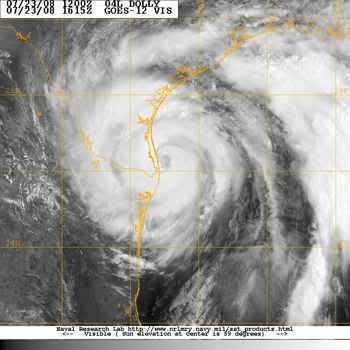
Jeetje zeg, wat kan dat snel gaan he! En zo zie je maar weer wat voor een groot land Mexico is, hier in Yucatan schijnt de zon alweer ruim een dag, en we hadden nauwelijks wind toen Dolly hier overheen trok. Als we een echte hurricane krijgen zal ik zsm foto's posten 
Hoop dat Dolly niet teveel schade aanricht in het noorden, en in de US.
Hoop dat Dolly niet teveel schade aanricht in het noorden, en in de US.
Orkaan Dolly bereikt Texasquote:Met windsnelheden van 160 kilometer per uur heeft orkaan Dolly woensdag het toeristeneiland South Padre Island vlak voor het vasteland van de Amerikaanse staat Texas bereikt. Dat meldden Amerikaanse media.
Verslaggevers in het getroffen gebied maakten melding van rondvliegende dakpannen en uithangborden. De krachtige wind gaat gepaard met zware regenval. Dolly zal de komende uren in westelijke richting over het uiterste zuiden van Texas langs de grens met Mexico trekken. In totaal hebben honderdduizenden Texanen en Mexicanen zich opgemaakt voor de orkaan, die woensdag in kracht toenam tot de categorie 2. De autoriteiten in Mexico lieten meer dan 20.000 mensen evacueren.
Meteorologen zijn bang voor zware regenval tot 25 centimeter, wat tot overstromingen kan leiden. Een aantal oliemaatschappijen, waaronder Shell, haalde personeel van boortorens in de Golf van Mexico. De Amerikaanse luchtmacht verplaatste meer dan honderd toestellen van een militair vliegveld naar bases elders in Texas en New Mexico.
Dolly is de tweede orkaan van dit jaar. Het orkanenseizoen (juni tot eind november) wordt volgens voorspellers actiever dan gemiddeld.
I Ask for so Little. Just Fear Me, Love Me, Do as I Say, and I Will Be Your Slave.
User van NWS zei: Maak van internet een schoner riool! YES WE CAN!
User van NWS zei: Maak van internet een schoner riool! YES WE CAN!
quote:Ravage in Texas en Mexico na Dolly
AUSTIN - De orkaan Dolly heeft woensdagavond (plaatselijke tijd) een spoor van vernielingen achtergelaten in de Amerikaanse staat Texas en in het noordoosten van Mexico.
In de Mexicaanse stad Matamoros zaten honderdduizenden mensen door Dolly zonder drinkwater. In het zuiden van Texas kwamen meer dan 120.000 huishoudens zonder stroom te zitten.
Een 17-jarige jongen raakte gewond op een eiland voor de kust van Texas. Hij werd door de orkaan van een balkon geblazen en viel van de zevende verdieping.
Overstromingen
Dolly zorgde ook voor overvloedige regenval in de getroffen gebieden. Gevreesd wordt dat dit de komende dagen overstromingen veroorzaakt, wanneer al het regenwater uitkomt in de grensrivier de Rio Grande.
Inmiddels is Dolly afgezwakt tot een tropische storm. De schade wordt geschat op ongeveer 1 miljard dollar (ongeveer 635 miljoen euro).
waarom ga je midden in een orkaan op een balkon op de zevende verdieping staan 
trouwens wel opvallend dat er "gewond" staat, en niet "morsdood".
trouwens wel opvallend dat er "gewond" staat, en niet "morsdood".
quote:Doden door Dolly in Mexico
AUSTIN - Zeker twee mensen in Mexico zijn gedood door de orkaan Dolly. Een visser verdronk, een andere man werd geëlektrocuteerd door een geknapte stroomkabel. Meerdere collega's van de visser gelden als vermist.
De hevige storm trok in de nacht van woensdag op donderdag een spoor van vernielingen in het noordoosten van Mexico en in de aangrenzende Amerikaanse staat Texas. De schade wordt geschat op zeker 1 miljard dollar (ongeveer 635 miljoen euro).
Hulpverlening
In het zuiden van Texas kwamen meer dan 120.000 huishoudens zonder stroom te zitten. De autoriteiten riepen voor veertien regio's de noodtoestand uit om hulpverlening te bespoedigen.
Dolly veroorzaakte ook overvloedige regenval. Gevreesd wordt dat dit de komende dagen overstromingen veroorzaakt, wanneer al het regenwater uitkomt in de grensrivier Rio Grande.
Dolly zwakte inmiddels af tot een tropische storm.
Doden en duizenden daklozen door storm Fay
SANTO DOMINGO - Zeker vijf mensen zijn zaterdag in de Dominicaanse Republiek en Haïti omgekomen door zware regenval bij het passeren van de tropische storm Fay.
Door verwoestingen aan huizen werden in de Dominicaanse Republiek ongeveer 12.000 mensen dakloos.
De autoriteiten in de Dominicaanse Republiek lieten weten dat 2300 huizen zijn verwoest en dat zeventien plaatsen van de buitenwereld zijn afgesloten. Zowel in Haïti als in de Dominicaanse Republiek worden enkele mensen vermist.
Het Amerikaanse Nationaal Orkaancentrum NHC in Florida meldde dat Fay zich zondagmorgen om 5.00 uur (Nederlandse tijd) 280 kilometer ten zuidoosten van Camaguey op Cuba bevond. De storm bereikt Cuba in de loop van zondag. Uit voorzorg hebben de Cubaanse autoriteiten evacuaties gelast uit kustgebieden die onder dreigen te lopen
Fay, de eerste storm dit jaar die een beetje dicht bij mij in de buurt komt (noort florida). Laat maar komen 
Pak je kite-surf-spullen maar en als je ze niet hebt dan kan je ze vast wel van deze gast lenenquote:Op dinsdag 19 augustus 2008 02:59 schreef devzero het volgende:
Fay, de eerste storm dit jaar die een beetje dicht bij mij in de buurt komt (noort florida). Laat maar komen

Wat een sukkel
Hij heeft het wel overleefd, maar hij ligt wel in het ziekenhuis
“Never assume you will win, never feel safe, never feel confident, never send a "We got this!" text, never take anything for granted, never pose for a picture late in the game, always expect the worst while rooting for the best.”
Allemachtig, die maakt echt een klap.quote:Op dinsdag 19 augustus 2008 18:34 schreef PirE het volgende:
[..]
Pak je kite-surf-spullen maar en als je ze niet hebt dan kan je ze vast wel van deze gast lenen
Wat een sukkel
Hij heeft het wel overleefd, maar hij ligt wel in het ziekenhuis
Kite surfen zit er voorlopig niet in voor dit persoon.
Volgens de verwachting komt het zaterdag morgen vlak bij mij in de buurt, maar dan zal het hooguit een depressie zijn met veel regen. Jammer, want dat kite vliegen lijkt me wel tofquote:Op dinsdag 19 augustus 2008 18:34 schreef PirE het volgende:
Pak je kite-surf-spullen maar en als je ze niet hebt dan kan je ze vast wel van deze gast lenen

Tropical Storm Fay
Tropical Storm Fay came ashore on the Florida Peninsula near Naples, the same area struck in 2005 by Hurricane Wilma. Unlikely Wilma, Fay came ashore without reaching hurricane status, though its heavy rains brought concerns about potential flooding, as well as strong storm surge. Just days before, Fay had caused several deaths in the Dominican Republic, as well as flash floods in Cuba and Haiti. On August 18, forecasters had predicted that Fay would intensify enough to become a Category One Hurricane. This was expected to happen just as the storm was making its first landfall in Florida, crossing the Key Islands. However, the storm merely retained a steady strength as it crossed from Cuba to the Gulf of Mexico. With 95 kilometer per hour (60 mile per hour) winds and a storm surge between 60 to 120 centimeters (two to four feet) above normal, Fay merited tropical storm warnings from the National Hurricane Center throughout much of southern Florida.
This photo-like image was made from data collected by the Moderate Resolution Imaging Spectroradiometer (MODIS) on NASA’s Terra satellite captured this image of the storm at 12:15 p.m. local time (16:15 UTC) on August 19. Fay had made second landfall on the Florida Peninsula just a few hours earlier and was travelling gradually up the length of the state. Despite failing to reach minimal hurricane strength, Fay here looks more like a hurricane than it did the previous day when the storm had a less intense spiral structure and lacked a central eye, something clearly visible in this image. Within hours of this image being acquired, several tropical storm warnings along the east coast of Florida were rescinded, but new warnings to the north were being issued, including hurricane warnings on the Atlantic Coast north of the storm. Forecasters at the National Hurricane Center now believed the storm would reach the Atlantic Ocean and rebuild to hurricane status off the coast, then turn westward to come ashore a third time in Florida near the border with Georgia.
quote:Fay looks like it could be a 'boomerang storm'
FORT PIERCE, Florida (CNN) -- Tropical Storm Fay moved just off the east coast of Florida early Wednesday after spawning at least seven tornadoes that ripped across sections of the state, the National Hurricane Center reported.
The storm is expected to make a small loop into the Atlantic and strengthen into a hurricane before paying a return visit to Florida, likely making landfall somewhere in the Jacksonville or St. Augustine area, according to the hurricane center.
"This storm is going to be with us for a while," said Florida Gov. Charlie Crist. "Looks like it could be a boomerang storm."
A hurricane watch has been issued for Florida's east coast, from north of Flagler Beach to Altamaha Sound.
Fay weakened throughout the evening as its maximum sustained winds dropped to near 50 mph (85 km/hr), with higher gusts, forecasters said.
As of 2 a.m., the center of the storm was about 5 miles (10 km) northwest of Sebastian and about 15 miles (25 km) south-southeast of Melbourne, the National Hurricane Center said. Fay was traveling north-northeast at 7 mph (11 km/hr).
cnn

[ Bericht 3% gewijzigd door Frutsel op 20-08-2008 14:09:02 ]
Typhoon NURI gaat China en de Filipijnen hard treffen.
quote:Affected Population
Up to 4.79 million people can be affected by wind speeds of hurricane strength or above. In addition, 0.83 million people are living in coastal areas below 5m and can therefore be affected by storm surge.
Affected Country (provinces) (population)
China (Guangdong) (69623060), Philippines (Cordillera Administrative Region) (1146000), Philippines (Cagayan Valley) (2341000), Philippines (Ilocos) (3551000).
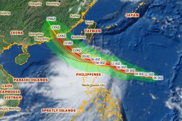
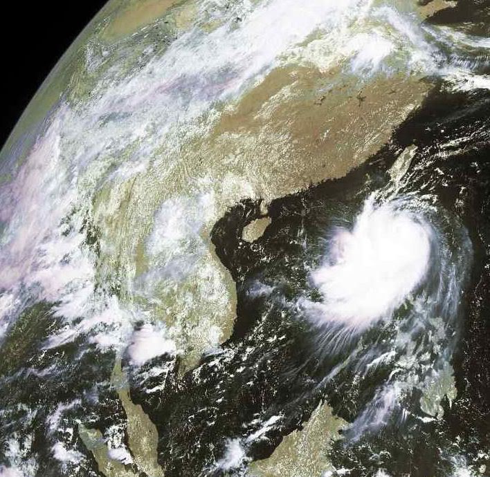
Nuri zou nu zo ongeveer aan land moeten komen?
[b]Op maandag 6 september 2010 00:28 schreef tong80 het volgende:[/b]
GVD Wat moet jij een trotse vader zijn :)
:P
GVD Wat moet jij een trotse vader zijn :)
:P
quote:Meanwhile, in the Atlantic Basin, there are a couple of systems being monitored for further tropical development.
One system is located in the southeast Caribbean Sea. Additional development of this disturbance is possible over the next couple of days as it moves toward the west or west-northwest at 10 to 15 mph. The other system being watched is located about 525 miles east-northeast of the Leeward Islands. Some slow development of this disturbance is possible over the next or two as it plows toward the west-northwest or northwest at about 15 mph. In the eastern Pacific, Tropical Storm Julio (50 mph) is headed toward the southern Baja Peninsula of Mexico. As of 8 a.m. PDT, Julio was located about 35 miles south of Cabo San Lucas, Mexico, and was moving toward the north-northwest at 13 mph. Some slight strengthening of Julio is possible before its center reaches southern Baja California this afternoon or tonight.
Tropical storm warnings extend southward from Punta Abreojos on the west coast of the Baja Peninsula, and from Mulege southward on the east coast. Tropical storm watches are in effect on the west coast north of Punta Abreojos to El Pocito, and on the east coast north of Mulege to Bahia San Juan Baustista.
quote:The rains from Tropical Depression Fay will continue to threaten flooding in the Deep South today. The center of Fay (currently located near the border of southeast Mississippi and southwest Alabama) is expected to drift slowly westward for another 24 hours or so. Gusty--but not damaging--winds will persist over much of Louisiana, Mississippi, Alabama, Georgia, and the Florida Panhandle.
The heaviest rain today will splash down north and west of Fay's center over northern Alabama, northern and western Mississippi, southwest Tennessee and over the lower Mississippi River Valley. Flood watches are widespread.
Gustav op weg naar Haïti, Cuba (Golf van Mexico?).


Dostojewski: "Je kunt je niet van je eigen gezond verstand overtuigen door je buurman op te sluiten."
het is al weer een hurricane.quote:HURRICANE GUSTAV TROPICAL CYCLONE UPDATE
NWS TPC/NATIONAL HURRICANE CENTER MIAMI FL AL072008
220 AM EDT TUE AUG 26 2008
REPORTS FROM AN AIR FORCE HURRICANE HUNTER AIRCRAFT INDICATE THAT
GUSTAV HAS BECOME A HURRICANE WITH MAXIMUM WINDS NEAR 80 MPH...130
KM/HR. THIS CHANGE WILL BE REFLECTED IN THE 5 AM EDT ADVISORY.
erg gevaarlijke route gaat ie volgen.
eerste haïti wat altijd zwaar lijdt doordat alles wegspoeld door teveel houtkap.
dan cuba en daarna golf van mexico ergens tussen texas-florida aan land als CAT4-5?
Dostojewski: "Je kunt je niet van je eigen gezond verstand overtuigen door je buurman op te sluiten."
quote:PORT-AU-PRINCE, Haiti — Gustav continued to gain strength after becoming a hurricane early Tuesday and forecasters said it could become a Category 2 hurricane before hitting Haiti's southern coast.
The fast-forming storm was also on track to hit Cuba.
The National Hurricane Center in Miami said the hurricane's maximum sustained winds were near 85 mph with higher gusts. A Category 2 hurricane has winds of 96 mph or higher.
Haitians were told to prepare for evacuations as the storm formed Monday in the Caribbean. Haiti upgraded storm warnings to hurricane warnings along much of its coast as Gustav closed in from the south. A warning means hurricane conditions are expected within 24 hours.
Haitians were told to prepare for evacuations as the storm formed Monday in the Caribbean. Haiti upgraded storm warnings to hurricane warnings along much of its coast as Gustav closed in from the south.
Forecasters said storm preparations in Haiti should be rushed to completion and that floods and landslides were possible across its southern peninsula. The forecasts suggested Gustav's eye could pass near the capital of Port-au-Prince, home to nearly 3 million people
At 5 a.m. EDT Tuesday, the hurricane was centered about 100 miles south-southeast of Port-au-Prince and was moving toward the northwest near 9 mph.
On Monday, Carnival Cruise Lines diverted one of its ships to a Mexican port instead of Montego Bay, Jamaica, to avoid the storm, company spokesman Vance Gulliksen said. Other cruise lines said they were closely tracking its path.
After passing over Haiti, Gustav was expected to hit Cuba's southeastern tip Wednesday.
The commander of the Guantanamo military base in Cuba, where the U.S. holds about 265 men, many suspected of belonging to Al Qaeda or the Taliban, ordered U.S. military personnel to prepare for a hit late Tuesday or early Wednesday.
"We're monitoring the track of ... Gustav and reviewing our destructive weather plans and procedures," said Army Maj. Richard Morehouse, a spokesman for detention operations at the base.
Vulnerable to high winds are dozens of tents pitched on an abandoned runway where those attending war-crimes trials for alleged terrorists are housed. No hearings are scheduled this week.
Morehouse told The Associated Press the lockups housing all detainees "are capable of withstanding hurricane force winds and rain."
Haitians were told to stay on alert for evacuations and to avoid crossing flooded rivers, the cause of nearly all 23 deaths on the greater island of Hispaniola during Tropical Storm Fay earlier this month.
The agricultural ministry, already dealing with a food crisis and fighting to raise national production, advised farmers to put livestock in safe locations. All maritime activities also were suspended until further notice.
Dominican authorities also issued warnings and advised small boats to remain in port, even on the north side of the island of 17 million people.
Meanwhile, two other storms were lashing the southeastern U.S. and Mexico's Pacific coast.
The remnants of Fay brought heavy rain and winds from Georgia to Louisiana. Floridians were still mopping up floodwaters from a storm that stuck around for a week and made a historic four landfalls, dumping more than 30 inches of rain along the central Atlantic coast.
The National Weather Service said the vestiges of Fay would deluge northern Georgia with 3 inches to 5 inches of rain expected in the Atlanta area and up to 8 inches in northeast Georgia. In Alabama, flash flood and tornado warnings were posted.
In Mexico, Tropical Depression Julio dumped rain on the central Baja California peninsula before heading toward the northern Gulf of California.
The hurricane center said late Monday that Julio was downgraded from a tropical storm to a tropical depression. The Mexican government lifted all tropical storm warnings.
Julio caused little major damage but forecasters said it could drench the U.S. Southwest with rain in the coming days.
The National Hurricane Center said Julio was located about 40 miles southeast of Bahia de Los Angeles in Baja California, Mexico, and was moving north-northwest at near 7 mph (Bron: FOX
Nuri heeft inderdaad gezorgd voor flink wat regen in Manila (maar had een paraplu, dus viel wel mee) en heeft daarna gezorgd dat het een bende was op HongKong Airport met uitgevallen vluchten, vertragingen e.d.quote:Op dinsdag 19 augustus 2008 22:15 schreef Frutsel het volgende:
Nuri gaat voor heel wat overlast zorgen denk ik
[ afbeelding ]
Gelukkig viel het bij mij mee, slechts 3 uur vertraging. Maar anderen zaten er dus al van de dag ervoor.
Ik ben een eckte rapnegert
gevaarljike koers, zo vlak onder Cuba langs.... en hoe 'ie daarna verder gaat, wie weet..quote:Op dinsdag 26 augustus 2008 15:01 schreef Frutsel het volgende:
Gustav kon wel eens een zeer gevaarlijke storm worden...
[ afbeelding ]
Wordt het straks weer New Orleans?
[b]Op maandag 6 september 2010 00:28 schreef tong80 het volgende:[/b]
GVD Wat moet jij een trotse vader zijn :)
:P
GVD Wat moet jij een trotse vader zijn :)
:P
Sneu dat de FEMA nog bestaat en Bush nog president is als het zou gebeurenquote:Op dinsdag 26 augustus 2008 15:01 schreef Frutsel het volgende:
Gustav kon wel eens een zeer gevaarlijke storm worden...
[ afbeelding ]
Wordt het straks weer New Orleans?
Gustav Explodes Into a Hurricane in Less Than a Day, Targets Haiti
At 8:00 a.m. EDT the center of Hurricane Gustav was located near latitude 17.5 north and longitude 72.0 west or about 75 miles south-southeast of port au prince haiti and about 265 miles southeast of Guantanamo, Cuba. Maximum sustained winds have increased to near 90 mph with higher gusts. Gustav is a category one hurricane on the Saffir-Simpson scale. The hurricane could become a category two hurricane before landfall in Haiti later today.
Gustav is moving toward the northwest near 9 mph and this motion is expected to continue today with a turn toward the west-northwest and a decrease in forward speed forecast on Wednesday. On this track this hurricane should move over southwestern Haiti later today and near or just south of eastern Cuba on Wednesday, Aug. 27. The latest minimum central pressure reported by an Air Force Reserve reconnaissance aircraft is 981 millibars.
Gustav is going to be a big rainmaker, like Fay. He's expected to produce total rainfall accumulations of 4 to 7 inches over southern Hispaniola and Jamaica, with isolated maximum amounts of up to 15 inches possible. These rains may produce fife-threatening flash floods and mud slides. Coastal storm surge flooding of 2 to 4 feet above normal tide levels can be expected near and to the east of where the center makes landfall.
The AIRS images show the temperature of the cloud tops or the surface of the Earth in cloud-free regions. The lowest temperatures (in purple) are associated with high, cold cloud tops that make up the top of Hurricane Gustav. The AIRS data creates an accurate 3-D map of atmospheric temperature, water vapor and clouds, all of which are helpful to forecasters.
The infrared signal of the AIRS instrument does not penetrate through clouds. Where there are no clouds the AIRS instrument reads the infrared signal from the surface of the ocean waters, revealing warmer temperatures in orange and red.
Gustav Forecast to be a Major Hurricane in the Gulf
After Gustav crosses Haiti and enters the Gulf of Mexico, he's forecast to be over extremely warm waters with relatively light shear (winds that tear a storm apart). The National Hurricane Center's official intensity forecast now calls for Gustav to be a major hurricane in the northwestern Caribbean Sea. Most indications are that Gustav will be an extremely dangerous hurricane in the northwestern Caribbean Sea in a few days.
Wij kregen vandaag een officiele waarschuwing via sms (doet de overheid hier automatisch in noodgevallen of orkanen). Gustav wordt hier vanuit Cancun zéér scherp in de gaten gehouden. Dit gaat een grote storm worden! Wij verwachten hier dat er alleen regen komt, maar je weet het nooit, zodra ze over land gaan wijken ze vaak af van koers. En linkse oranje depressie, kan ook nog wel eens problemen op gaan leveren. Het is de laatste weken abnormaal warm geweest, bijna te warm om fatsoenlijk buiten te lopen. Iedereen klaagde erover. Zou dat een voorbode zijn voor wat komen gaat?
Gelukkig ben ik net verhuisd naar een orkaanveilig appartement
Gelukkig ben ik net verhuisd naar een orkaanveilig appartement
En het oog is aan land gegaan in Haïti:
THE EYE OF HURRICANE GUSTAV MADE LANDFALL ON THE SOUTHWEST PENINSULA
OF HAITI ABOUT 10 MILES...16 KM...WEST OF JACMEL...SHORTLY AFTER
100 PM EDT...1700 UTC.
THE EYE OF HURRICANE GUSTAV MADE LANDFALL ON THE SOUTHWEST PENINSULA
OF HAITI ABOUT 10 MILES...16 KM...WEST OF JACMEL...SHORTLY AFTER
100 PM EDT...1700 UTC.
Ik zou op blijven letten ja! Het is een beetje 50/50: GFDL voorspelt herrie in de VS, maar de modellen van de UK MetOffice en het ECMWF voorspellen dat die baan geblokkeerd wordt(blijft) en dan is Yucatan maar weer eens de pineut.quote:Op dinsdag 26 augustus 2008 21:44 schreef Vogue het volgende:
Wij kregen vandaag een officiele waarschuwing via sms (doet de overheid hier automatisch in noodgevallen of orkanen). Gustav wordt hier vanuit Cancun zéér scherp in de gaten gehouden. Dit gaat een grote storm worden! Wij verwachten hier dat er alleen regen komt, maar je weet het nooit, zodra ze over land gaan wijken ze vaak af van koers. En linkse oranje depressie, kan ook nog wel eens problemen op gaan leveren. Het is de laatste weken abnormaal warm geweest, bijna te warm om fatsoenlijk buiten te lopen. Iedereen klaagde erover. Zou dat een voorbode zijn voor wat komen gaat?
Gelukkig ben ik net verhuisd naar een orkaanveilig appartement
hij is bijna hurricane af nu. nog net geen tropische storm weer.
maar Gustav kan overal naar toe nog.
[ Bericht 4% gewijzigd door Caesu op 26-08-2008 23:15:26 ]
maar Gustav kan overal naar toe nog.
[ Bericht 4% gewijzigd door Caesu op 26-08-2008 23:15:26 ]
Dostojewski: "Je kunt je niet van je eigen gezond verstand overtuigen door je buurman op te sluiten."
Zal wel loslopen..... vlak voor het aan land gaan zakt het bijna altijd 2 schalen down.quote:Op woensdag 27 augustus 2008 09:29 schreef Frutsel het volgende:
Ik zal straks eens een eigen topic gaan aanmaken... dit kon wel eens fout gaan
Van C3 naar C1...
Katrina was boven de golf van Mexico een dikke C5+ (Rita was zelfs nog sterker). Maar boven land was het een dikke C2/C3.
Klopt, maar je ziet ook wel dat ze het als cat.3 inschalen maar het warme zeewater doet ineens beter zijn best... voor je het weet wordt het toch een cat.4 en gaat ie als 3 aan land... en New Orleans loopt denk ik al onder bij een Cat 1quote:Op woensdag 27 augustus 2008 09:42 schreef Drugshond het volgende:
[..]
Zal wel loslopen..... vlak voor het aan land gaan zakt het bijna altijd 2 schalen down.
Van C3 naar C1...
Katrina was boven de golf van Mexico een dikke C5+ (Rita was zelfs nog sterker). Maar boven land was het een dikke C2/C3.
Ben benieuwd... maar qua trajectorie en kracht is nog te veel onduidelijk.quote:Op woensdag 27 augustus 2008 09:54 schreef Frutsel het volgende:
[..]
Klopt, maar je ziet ook wel dat ze het als cat.3 inschalen maar het warme zeewater doet ineens beter zijn best... voor je het weet wordt het toch een cat.4 en gaat ie als 3 aan land... en New Orleans loopt denk ik al onder bij een Cat 1
Fay floods Florida
Tropical Storm Fay spent six days zig-zagging across Florida and dumping heavy rain on the entire state between August 19 and August 24, 2008. By August 25, when the Moderate Resolution Imaging Spectroradiometer (MODIS) on NASA’s Terra satellite captured the top image, floods inundated much of Florida. The worst of the flooding was along the St. Johns River in central Florida, which reached 10.95 feet near Lake Harney on August 26 and water levels were still rising, said the National Weather Service. The river floods when water levels reach 8.5 feet.
Too small to be visible the previous month, the swollen river paints a wide black ribbon down the bright green plant-covered landscape in the top image. Tiny clouds, pale blue and white in this type of image, dot the skies in both images. The large image, which includes a broader area, shows additional flooding around Lake Okeechobee.
The St. Johns River lines the east coast of Florida near Cape Canaveral, home to NASA’s Kennedy Space Center. Tropical Storm Fay closed the center between August 19 and August 21, but caused only minor damage to the facilities and no damage to space hardware, according to initial assessments.
En de volgende storm, Hanna, staat op de kaart:

[b]Op maandag 6 september 2010 00:28 schreef tong80 het volgende:[/b]
GVD Wat moet jij een trotse vader zijn :)
:P
GVD Wat moet jij een trotse vader zijn :)
:P
Ja, en er zijn nog 3 andere systemen actief! Gustav vormt nog steeds een behoorlijk gevaar voor ons. Je merkt er desalniettemin niets van dat er een orkaan / TS in de buurt is, de zon schijnt en de lucht is blauw, as usual
Hanna zou wel eens een fishspinner kunnen blijken, maar een dubbele penetratie van Florida zit duidelijk ook nog in de mogelijkheden.
Gustav is overigens vanochtend spontaan een stukje naar het zuiden versprongen. Zit de belhamel ineens net onder Jamaica.
Gustav is overigens vanochtend spontaan een stukje naar het zuiden versprongen. Zit de belhamel ineens net onder Jamaica.
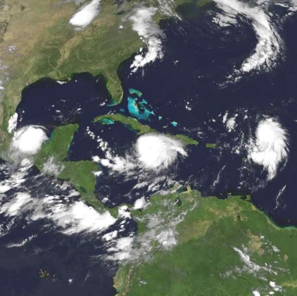
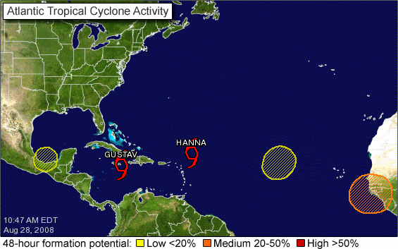
quote:MIAMI — The National Hurricane Center says Tropical Storm Hanna has formed northeast of the northern Leeward Islands in the Atlantic.
The eighth tropical storm of the Atlantic season had top sustained winds near 40 mph Thursday. Its center was about 305 miles northeast of the northern Leeward Islands and was moving toward the west-northwest near 12 mph.
Hanna could produce rainfall of 1 to 4 inches across parts of the Leeward Islands. It's too soon to say if Hanna will affect the U.S.

1 to 4 inches is een flinke regenbui, niet meer.quote:Op vrijdag 29 augustus 2008 00:03 schreef Frutsel het volgende:
Hanna could produce rainfall of 1 to 4 inches across parts of the Leeward Islands. It's too soon to say if Hanna will affect the U.S.
http://www.foxnews.com/story/0,2933,411862,00.htmlquote:he National Guard was scheduled to begin convoying supplies and troops into New Orleans on Friday, while some nursing homes and hospitals planned to start moving patients further inland and the state began moving 9,000 inmates from coastal lockups.
An evacuation order for New Orleans was likely, Mayor Ray Nagin said, but not before Saturday Meanwhile, residents of areas further south could be told to leave starting Friday, Gov. Bobby Jindal said.
http://afp.google.com/article/ALeqM5h_pRg8PjsWyfviUQrPDgGKV_FnoQquote:NEW ORLEANS (AFP) — Authorities began busing people out of areas of New Orleans on Friday ahead of the possible landfall of Tropical Storm Gustav, forecast to hit the region as a powerful hurricane early Tuesday.
Officials in Saint Charles parish, in western New Orleans, have been busing out residents who want to leave the city.
While the Friday evacuations are voluntary, authorities in Saint Charles and the five other New Orleans parishes are planning mandatory evacuations starting noon Saturday if Gustav remains on the same path.
Parish officials "are extremely concerned about storm surge flooding" that Gustav would cause, noting that "the entire parish remains at risk.
"All residents should be taking steps to secure their homes and prepare for evacuation NOW," read a statement from the office of Parish President V.J. St. Pierre.
Dostojewski: "Je kunt je niet van je eigen gezond verstand overtuigen door je buurman op te sluiten."
quote:Gustav wordt orkaan
MIAMI - De tropische storm Gustav is in het Caribisch gebied boven zee in kracht toegenomen en tot een orkaan uitgegroeid. Dat heeft het Amerikaanse National Hurricane Center (NHC) vrijdag laten weten.
Uit observaties vanuit de lucht blijkt dat Gustav nu windsnelheden tot 120 kilometer per uur bereikt. Daarmee is hij een orkaan van de eerste en laagste categorie op de zogeheten Saffir-Simpsonschaal, die vijf schalen kent.
Gustav heeft inmiddels zeker 78 levens geëist en grote verwoestingen aangericht op Haïti, de Dominicaanse republiek en Jamaïca. De orkaan stevent vrijdag af op de Kaaimaneilanden en zal zaterdag het westen van Cuba bereiken.
Gebied
De Kaaimaneilanden is Brits overzees gebied en ligt op 800 kilometer van Florida en 300 kilometer van Jamaïca.
De 40.000 inwoners van het vakantie- en belastingparadijs hebben de luiken gesloten van woningen en resorts en blijven zoveel mogelijk binnen in afwachting van Gustav.
Derde categorie
Gustav zal naar verwachting een orkaan van de derde categorie zijn als hij waarschijnlijk dinsdag het Amerikaanse vasteland bereikt.
Dat meldden functionarissen van de Amerikaanse rampenbestrijdingsdienst FEMA vrijdag.
http://www.nola.com/hurri(...)sh_plans_lockdo.htmlquote:St. Bernard Parish plans "lockdown"
by Leslie Williams, The Times Picayune
Friday August 29, 2008, 8:35 PM
St. Bernard Parish President Craig Taffaro Jr. announced late Friday night that he plans to call a mandatory evacuation for his parish at 4 p.m. Saturday, which will be followed immediately by a "lockdown" to prevent anyone from entering the parish.
Anyone who does not comply with the mandatory evacuation will be required to remain in his or her house, he said.
Traveling within the parish will not be allowed. And anyone arrested for violating the multi-day curfew will be sent to Angola, not the parish prison, he said.
Only when the threat of Gustav has passed will anyone be allowed to return, beginning with first responders, Taffaro said.
Exceptions will occur for residents who may want to leave after the 4 p.m. deadline, but that's it, he said.
The mandatory evacuation will be called unless the storm "stalls out," Taffaro said. Residents are being ordered to leave "for their protection" from gale force winds, he said.
Bush en Cheney waren gepland maandagavond te spreken op de Republican National Convention.
maar waarschijnlijk laten ze zich niet zien daar, ook niet via de satelliet.

daar komt McCain dan goed vanaf op die manier.
Dostojewski: "Je kunt je niet van je eigen gezond verstand overtuigen door je buurman op te sluiten."
Huh, Angola het land in Afrika? Ik snap het niet volgens mij.quote:And anyone arrested for violating the multi-day curfew will be sent to Angola, not the parish prison, he said.
het is een gevangenis (state prison):
http://www.corrections.state.la.us/lsp/
vernoemd naar een plantage op die plek, en die slaven kwamen uit Angola.
http://www.corrections.state.la.us/lsp/
vernoemd naar een plantage op die plek, en die slaven kwamen uit Angola.
Dostojewski: "Je kunt je niet van je eigen gezond verstand overtuigen door je buurman op te sluiten."
die gevangenis ligt niet zo gek ver van de kust.
en aan drie kanten omgeven door de mississippi rivier, die toch al vaak overstroomt.
dus zo moeten wel een goed evacuatie-plan hebben voor het geval gustav daar precies langs komt.
de gevangenis in new orleans zelf wordt daar al naar toe ge-evacueerd, het zal al wel druk worden.
en aan drie kanten omgeven door de mississippi rivier, die toch al vaak overstroomt.
dus zo moeten wel een goed evacuatie-plan hebben voor het geval gustav daar precies langs komt.
de gevangenis in new orleans zelf wordt daar al naar toe ge-evacueerd, het zal al wel druk worden.
Dostojewski: "Je kunt je niet van je eigen gezond verstand overtuigen door je buurman op te sluiten."
NOS TTquote:***************************************
Gustav groeit naar categorie 4
***************************************
` Vanwege de naderende orkaan Gustav
heeft de Amerikaanse president Bush de
noodtoestand afgekondigd in Louisiana
en Texas.Daardoor kan de hulpverlening
vanuit Washington worden geregeld.
Bush wil voorkomen dat de hulpverlening
weer misloopt,zoals drie jaar geleden
toen Katrina het gebied rond New
Orleans trof.Langs de Golfkust vielen
toen 1800 doden.
Gustav is de afgelopen uren snel in
kracht toegenomen en het Hurricane
Centre heeft hem nu ingeschaald als een
orkaan met kracht 4 met windsnelheden
van meer dan 230 kilometer per uur.De
orkaan komt dinsdag in de VS aan land.
***************************************

Dostojewski: "Je kunt je niet van je eigen gezond verstand overtuigen door je buurman op te sluiten."
TT aangepast zodat het duidelijker is dat je in het andere topic over Gustav kunt praten: Orkaan Gustav (cat.5) op ramkoers met New Orleans
Hier over evt. andere (aankomende) orkanen / tropische stormen.
Hier over evt. andere (aankomende) orkanen / tropische stormen.
Op nu.nl las ik dat Gustav zwaarder zal zijn dan Katrina... Hold on to your seats!
* I intend to live forever, so far so good! *
Dat lijkt me sterk. Katrina was een Cat 5 toch?quote:Op zondag 31 augustus 2008 10:58 schreef IkWilbert het volgende:
Op nu.nl las ik dat Gustav zwaarder zal zijn dan Katrina... Hold on to your seats!
Drugs are good mkay?
Categorie 6 bestaat idd niet, maar daarom kan Gustav wel zwaarder worden dan Katrina. Heeft gewoon te maken met hogere windsnelheden, meer neerslag, hogere stormvloed e.d.
Ja ok, als uit Gustav meer regen komt is de ravage misschien nog wel groter ja.quote:Op zondag 31 augustus 2008 22:05 schreef Eveli het volgende:
Categorie 6 bestaat idd niet, maar daarom kan Gustav wel zwaarder worden dan Katrina. Heeft gewoon te maken met hogere windsnelheden, meer neerslag, hogere stormvloed e.d.
Drugs are good mkay?
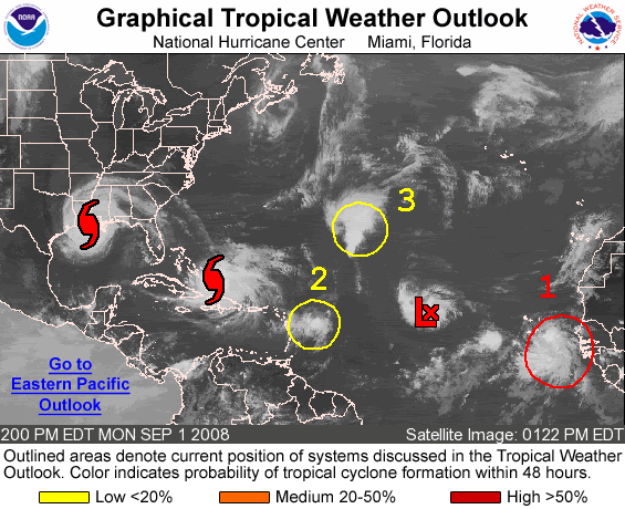

Ike is er nu ook al.
http://euler.atmos.colost(...)tic/track_early3.png
http://euler.atmos.colost(...)intensity_early3.png
http://euler.atmos.colost(...)tic/track_early3.png
http://euler.atmos.colost(...)intensity_early3.png
Dostojewski: "Je kunt je niet van je eigen gezond verstand overtuigen door je buurman op te sluiten."
Ike gaat recht op de GOM af
Ga er maar vanuit dat deze vanaf zaterdag gaat toenemen.
[ Bericht 48% gewijzigd door Drugshond op 02-09-2008 04:01:51 ]
Ga er maar vanuit dat deze vanaf zaterdag gaat toenemen.
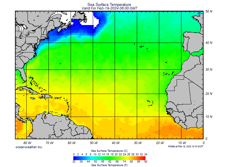

[ Bericht 48% gewijzigd door Drugshond op 02-09-2008 04:01:51 ]


quote:PROVIDENCIALES, Turks and Caicos — Hurricane Hanna was moving little early Tuesday as its rains continued to affect the Bahamas along with the Turks and Caicos Islands.
The hurricane also threatened to hit the southeast United States later in the week.
Meanwhile, Tropical Storm Ike was headed toward the Caribbean and another tropical depression emerged as a new threat in the Atlantic, according to the National Hurricane Center in Miami.
Hanna, with maximum sustained winds near 80 mph, lingered for much of Monday near Mayaguana and nearby islands in the southeast Bahamas.
There were no immediate reports of injuries or major damage, but emergency teams were standing by and would begin assessing the situation once the storm has cleared, said Stephen Russell, interim director of the Bahamas National Emergency Management Agency.
"I'm quite certain there is going to be damage, particularly in Mayaguana," he said.
Hanna also was bringing strong winds, heavy rain and pounding surf to nearby islands, including Inagua and Crooked Island, and Turks and Caicos Islands to the south
"Right now, the uncertainty is such that it could hit anywhere from Miami to the outer banks of North Carolina," said Jessica Schauer Clark, a meteorologist at the U.S. National Hurricane Center. "So people really need to keep an eye on it."
Ike was approaching behind Hanna with maximum sustained winds near 50 mph (85 kph). Ike was centered about 1,235 miles (1,985 kilometers) east of the Leeward Islands and moving west near 15 mph (24 kph) early Tuesday. The tropical storm was expected to gain strength over the next two days.
And behind Ike, a new tropical depression formed early Tuesday with maximum sustained winds near 35 mph. The depression was forecast to strengthen and the hurricane center said it would likely become a tropical storm later in the day. The depression was centered about 170 miles south-southeast of the southernmost Cape Verde Islands off the coast of Africa.
NASA was not taking any chances — it announced a delay of at least a day in the planned move of the space shuttle Atlantis from an assembly building at Florida's Kennedy Space Center to the launch pad. The move had been scheduled for Tuesday in preparation for an October mission to the Hubble Space Telescope.
Florida state officials also were keeping nervous watch on Hanna and the weather behind it, careful not to overextend the assistance it provides to other Gulf Coast states dealing with Gustav.
"The storm's on top of us right now and it's blowing really hard," said Miguel Campbell, a mechanic with the Bahamas Electricity Corp. on Mayaguana, where some 300 people were hunkered down.
Hanna's winds and rain reached all the way to Haiti, where thousands remain homeless in the wake of Gustav, which was downgraded to a tropical depression as it moved over Louisiana early Tuesday.
In Puerto Rico, authorities said one man from Colombia was killed and a woman from Brazil was missing after they were swept away in a river swollen with rain from Hanna. The two were students at the University of Puerto Rico on a trip to the island's east.
The European Union said Monday it would give $2.9 million to help the recovery from Gustav, which killed 94 people. The money will pay for clean water, food, medical care, shelter and basic household items in Haiti, Cuba, Jamaica and the Dominican Republic. In Haiti, 8,000 people are in temporary housing after high winds and floods destroyed homes and farms.

Wij hebben de dans ontsprongen. Geen zuchtje wind gehad in Cancun, het enige dat we hebben meegekregen was hoog water, waardoor de stranden voor de helft waren weggevaagd (zand was weg, er lagen kale rotsen ipv een zandstrand).
Ziet er lekker uit, 3 tropische stormen op een rijtje en een depressie in de US.
Ziet er lekker uit, 3 tropische stormen op een rijtje en een depressie in de US.
traffic jam 
Dostojewski: "Je kunt je niet van je eigen gezond verstand overtuigen door je buurman op te sluiten."
Ike kan gevaarlijk worden.... Een run laat zien dat hij kan uitgroeien tot een CAT-4 boven Cuba
Ook zijn trajectorie is nog steeds richting GOM.
Ook zijn trajectorie is nog steeds richting GOM.
Lekker heb je net Gustav gehad... komt Ike er ook nog eens aan....quote:Op woensdag 3 september 2008 03:06 schreef Drugshond het volgende:
Ike kan gevaarlijk worden.... Een run laat zien dat hij kan uitgroeien tot een CAT-4 boven Cuba
Ook zijn trajectorie is nog steeds richting GOM.
en dan lopen we hier te klagen over 't weer
To deny our impulses would deny the very thing that make us human.
Het is maar één run...quote:Op woensdag 3 september 2008 03:06 schreef Drugshond het volgende:
Ike kan gevaarlijk worden.... Een run laat zien dat hij kan uitgroeien tot een CAT-4 boven Cuba
Ook zijn trajectorie is nog steeds richting GOM.
* I intend to live forever, so far so good! *
Misschien gaat Josephine de oostkust van de VS wel treffen....
In NYC wachten ze ook al tijden op zon scenario... waar de meeste mensen verwachten dat het koude zeewater dat niet mogelijk moet kunnen maken... maar het verleden spreekt tegen ze
In NYC wachten ze ook al tijden op zon scenario... waar de meeste mensen verwachten dat het koude zeewater dat niet mogelijk moet kunnen maken... maar het verleden spreekt tegen ze
HANNA...25 doden op Haiti
quote:De tropische storm Hanna heeft op Haiti aan 19 mensen het leven gekost. Het zwaarst gestroffen is Gonaives in het midden van het land. President Preval vraagt om internationale hulp.
Door de orkaan Gustav kwamen in het Caribisch gebied 90 mensen om, van wie op Haiti zeker 60,en in de VS acht. De schade in Louisiana wordt geschat op vier à tien miljard dollar.
Gustav heeft vorige week op Cuba een snelheidsrecord gevestigd: hij raasde met 340 kilometer per uur over het westen van het land. Het vorige record werd in 1953 gevestigd in Mexico met een windsnelheid van 286 km per uur.
nos
quote:Storms swirl in Atlantic, deadly floods hit Haiti
NASSAU, Sept 2 (Reuters) - Heavy rains flooded parts of Haiti with head-high water on Tuesday and sent walls of mud down the hillsides, killing at least 25 people as Tropical Storm Hanna swirled over the Bahamas and took aim at the southeastern United States.
A new tropical storm, Josephine, formed off Africa behind Tropical Storm Ike. Both were moving westward just as Hurricane Gustav dissipated after slamming into the U.S. Gulf Coast near New Orleans.
The flurry of Atlantic storms underscored predictions for a busier than normal hurricane season and was worrisome news for U.S. oil and natural gas producers in the Gulf of Mexico, millions of people living in the Caribbean and on U.S. coasts, and farmers fearing flooded fields.
The U.S. government has forecast 14 to 18 tropical storms will form during the six-month season that began on June 1, more than the historical average of 10. Josephine was already the 10th, forming before the statistical peak of the season on Sept. 10.
By Tuesday night, Hanna was bearing down on Great Inagua Island with 65 mph (100 kph) winds, the U.S. National Hurricane Center said.
It was expected to strengthen back into a Category 1 hurricane on the five-step Saffir-Simpson scale of intensity, with winds of at least 74 mph (119 kph) on Wednesday or Thursday.
Hanna dumped torrential rains on the southeastern Bahamas, the Turks and Caicos islands, Haiti and the Dominican Republic.
In Haiti, heavy rains caused severe flooding in the northern port city of Gonaives, where thousands of people died four years ago during a similar catastrophe.
"The city is flooded and there are parts where the water gets to 2 meters (6.5 feet)," said civil protection director Alta Jean-Baptiste. "A lot of people have been climbing onto the tops of their houses since last night to escape the flooding."
Authorities said flooding and mudslides from the storm killed at least 25 people across Haiti, including 12 in low-lying Gonaives and three in the nearby town of Gros Morne.
FLORIDA EMERGENCY
Hanna was nearly stationary but was forecast to turn northwest on a track that would take it near the Bahamian capital of Nassau and near the U.S. East Coast on Thursday. It was likely to come ashore at the end of the week somewhere between northern Florida and the Carolinas.
Although the official forecast kept it over water as it skirted the Florida coast, state Gov. Charlie Crist declared a state of emergency.
Tropical Storm Ike headed west after forming on Monday between Africa and the Caribbean and appeared likely to become a hurricane that would threaten the Caribbean islands and possibly the United States.
It was too early to say where Ike might go but the storm drew the attention of energy companies running the 4,000 offshore platforms in the Gulf of Mexico that provide the United States with a quarter of its crude oil and 15 percent of its natural gas.
Ike was about 930 miles (1,500 km) east-northeast of the Leeward Islands and moving west at 17 mph (28 kph) late on Tuesday. Its top sustained winds had strengthened to 65 mph (100 kph) and were expected to reach hurricane strength of 74 mph (119 kph) on Wednesday.
Josephine swirled over the far eastern Atlantic about 180 miles (290 km) west-southwest of the Cape Verde Islands. It was moving west at 12 mph (19 kph), with top sustained winds of near 50 mph (85 kph), and could become a hurricane on Wednesday. (Additional reporting by Joseph Guyler Delva in Port-au-Prince; Writing by Tom Brown and Jane Sutton; Editing by Eric Walsh)
Hanna kan nog wel eens de oceaan over steken, England over en daarna een leuk stormpje in NL achter latenquote:Op woensdag 3 september 2008 10:27 schreef Frutsel het volgende:
Rare koers die Hanna ineens maakt of nie?
Tja, we zitten idd midden in het seizoen
Of Hanna als categorie 1quote:Op woensdag 3 september 2008 08:34 schreef Frutsel het volgende:
Misschien gaat Josephine de oostkust van de VS wel treffen....
In NYC wachten ze ook al tijden op zon scenario... waar de meeste mensen verwachten dat het koude zeewater dat niet mogelijk moet kunnen maken... maar het verleden spreekt tegen ze
Meet me in Montauk.... Nou ja, met dat stuk dat Hanna over land gaat in Carolina, zal er niet heel veel meer in zitten tegen de tijd dat ze in New England aankomt. En Josephine zit voorlopig wel op Clementine scenario lijken te zitten, maar die komt nog een stevige stroom de andere kant op tegen voor ze bij de VS zit. Die gaat dus Bertha 2 worden, denk ik.
Laat die nazomer hier maar komen
Laat die nazomer hier maar komen
Daar zat ik ook al aan te denken. Mag van mij.quote:Op woensdag 3 september 2008 20:17 schreef thijsdetweede het volgende:
Die gaat dus Bertha 2 worden, denk ik.
Laat die nazomer hier maar komen
Zolang ze maar uit Cuba wegblijven. Ik moet er nog langs in september!
Sex is not the answer. Sex is the question. 'Yes' is the answer.
Nu ook op foto verkrijgbaar
Nu ook op foto verkrijgbaar
Volgens de voorspelling ligt IKE als categorie 3 op 8 september voor de kust van Cuba.quote:Op woensdag 3 september 2008 20:51 schreef Keios het volgende:
Zolang ze maar uit Cuba wegblijven. Ik moet er nog langs in september!
Niet te zeggen. Als Ike Hanna achterna gaat en richting Georgia en Carolina gaat, is de kans iets minder groot. Steekt de klootzak Florida of Cuba over richting Golf van Mexico: Dan is alles mogelijk.
Maar goed, Wilma was ook een haveloos stormpje, 12 uur voordat ze onverwacht de diepste hurricane allertijden werd.
Maar goed, Wilma was ook een haveloos stormpje, 12 uur voordat ze onverwacht de diepste hurricane allertijden werd.
Denk het wel..... Nu wel na de update...quote:Op woensdag 3 september 2008 23:13 schreef Co_OL het volgende:
Gaat deze nog cat5 halen?
[ afbeelding ]
De Bahamas gaan plat.
[ Bericht 2% gewijzigd door Drugshond op 04-09-2008 04:30:05 ]
Hanna wordt nu overigens voorspeld voor New York (en eigenlijk de gehele oostkust tot in Canada aan toe), Tot nu toe als Cat1/Tropische storm. En wellicht dat er zomaar eens een restant naar Europa kan trekken omdat hij nergens het land in voorspeld wordt
Boh dit kan een heel leuk seizoen worden...
Boh dit kan een heel leuk seizoen worden...
Dat dus.quote:Op donderdag 4 september 2008 00:01 schreef thijsdetweede het volgende:
Maar goed, Wilma was ook een haveloos stormpje, 12 uur voordat ze onverwacht de diepste hurricane allertijden werd.
Voorlopig durft het NHC nog niet te veel zinnigs over Ike te zeggen, behalve dat het monster grofweg de track van Hanna blijft volgen. Er zijn wat ongustige omstandigheden op komst voor Ike, maar het kan zelfs zo zijn dat het gewoon een Big Bully is en zich nergens wat van aan gaat trekken.
Hanna zal wel de standaard route voor eastcoast hurricanes gaan volgen: Langs de kust van de VS, veel regen op de US Open, nog een laatste landfall als (Sub-)Tropical Storm in NewFoundland, en dan met de straalstroom mee naar Europa, gedissipeerd als gewoon lagedrukgebied.quote:Op donderdag 4 september 2008 09:37 schreef Tokamak het volgende:
Hanna wordt nu overigens voorspeld voor New York (en eigenlijk de gehele oostkust tot in Canada aan toe), Tot nu toe als Cat1/Tropische storm. En wellicht dat er zomaar eens een restant naar Europa kan trekken omdat hij nergens het land in voorspeld wordt
Boh dit kan een heel leuk seizoen worden...
Als je naar de globale circulaties in de atmosfeer kijkt, zijn er eigenlijk maar een paar wegen die die orkanen kunnen volgen.
Een Cat1 storm voor de kust van NY kan een ramp worden
Interessante docu over gezien, ik meldde het al eerder in dit topic dat ze daar al jaren bang voor zijn... tis vaker gebeurd dus "it can and will happen again"
Ike 
Cat 4 al?
Kan bijna een eigen topic krijgen
Interessante docu over gezien, ik meldde het al eerder in dit topic dat ze daar al jaren bang voor zijn... tis vaker gebeurd dus "it can and will happen again"
Ike
Cat 4 al?
Kan bijna een eigen topic krijgen
quote:Nieuwe orkaan Ike wint snel aan kracht
MIAMI/PORT-AU-PRINCE - De wervelstorm die na de inmiddels uitgewaaide orkaan Gustav is ontstaan, Ike, is boven de Atlantische Oceaan in kracht toegenomen tot de categorie drie.
Ike heeft daarmee windsnelheden van 185 kilometer per uur, volgens meldingen woensdag van het Amerikaanse National Hurricane Center.
Ike is woensdag erg snel van categorie één naar drie gegaan. De wervelstorm trekt waarschijnlijk begin volgende week langs de Bahamas.
Het is niet duidelijk hoe lang de orkaan zo krachtig blijft en welke richting die in noordwestelijke richting precies zal opgaan.
Hanna
Westelijker raast nog steeds de tropische storm Hanna. De autoriteiten in de Haïtiaanse hoofdstad Port-au-Prince meldden woensdag dat Hanna meer dan zestig levens heeft geëist.
Ongeveer eenderde van deze slachtoffers vond de dood in de derde stad van het land, Gonaïves. Het is een van de vele plaatsen in Haïti die te kampen heeft met overstromingen.
Gustav
Eerder geselde 'Gustav' het straatarme Haïti. Daarbij zijn circa tachtig doden gevallen.
Hanna trekt donderdag over de Bahamas en dan naar de zuidoostkust van de Verenigde Staten. Het kan als orkaan zaterdag de kust van de Verenigde Staten bereiken. Ike is nog circa duizend kilometer van de Bovenwindse Eilanden verwijderd.
Verder naar het oosten is er een tropische storm ontstaan die naam Josephine heeft gekregen, maar die zwakt inmiddels af. Het is de tiende tropische storm dit seizoen dat 1 juni begon.
Stormen
De Amerikaanse autoriteiten vrezen dat ze dit jaar in het zuidoosten en zuiden met veertien tot achttien stormen te maken krijgen. Een gemiddeld seizoen telt tien zulke stormen.
Een dramatisch record was het seizoen van 2005 toen naast de verwoestende orkaan Katrina nog 27 stormen tekeer gingen.
Nieuw op dit forum
Maar Hanna heeft al voor meer dan 90 doden gezorgd op Haiti.
En die Ike wordt helemaal erg als die ergens land gaat.
Maar Hanna heeft al voor meer dan 90 doden gezorgd op Haiti.
En die Ike wordt helemaal erg als die ergens land gaat.
-
Ik ben benieuwd hoeveel orkanen er nog zullen komen dit jaar. Ben bang dat het er nog wel wat zullen zijn.
quote:Op donderdag 4 september 2008 21:25 schreef TreyZ het volgende:
Maar Hanna heeft al voor meer dan 90 doden gezorgd op Haiti.
Hanna heeft met haar getreuzel wel de oceaan behoorlijk wat kouder gemaakt... Dat zal Ike wel relatief onder de duim houden.
Josephine is een mooie naam voor een orkaan, of mag ik dat niet zeggen. 
Ik wacht nog tot mijn naam voorbij komt, wat zal dat verwoestend zijn.
Ik wacht nog tot mijn naam voorbij komt, wat zal dat verwoestend zijn.
Life is Music
Josephine is sowieso een mooie naam, niks voor dat geweld.
"We meet every day at the same cafe, six-thirty and no one knows she'll be there."
Daar zou ik voorlopig nog niet al te zeker van zijn....
quote:IT CANNOT BE SAID ENOUGH THAT FIVE-DAY TRACK FORECASTS
CAN HAVE SIGNIFICANT ERRORS...AND COMBINED WITH THE FACT THAT THE
MODEL SPREAD IS STILL NOTABLE BEYOND 72 HOURS...ONE SHOULD NOT
FOCUS ON THE EXACT TRACK.
die rooi ook anders (nu althans)quote:Op vrijdag 5 september 2008 14:22 schreef Drugshond het volgende:
De blauwe lijn = Bijzonder gevaarlijk.
rood misschien nog wel gevaarlijker: blijft langer boven of dichtbij het warme zeewater, dus zal minder kracht verliezen
Ik ben een eckte rapnegert
quote:Tropical Storm Josephine
The outer bands of Tropical Storm Josephine cover the Cape Verde Islands off the west coast of Africa in this photo-like image captured on September 4, 2008. The Moderate Resolution Imaging Spectroradiometer (MODIS) on NASA’s Terra satellite captured the image at 11:20 a.m. local time (12:20 UTC). At that time, the storm had winds estimated between 83 and 93 km/hr (52 and 58 mph or 45 and 50 knots). The weak storm consists of loose bands of clouds roughly arranged in a circular shape in this image. Josephine was forecast to weaken slightly as it moved west across the Atlantic Ocean.

quote:Hurricane Ike
A hurricane’s structure is visible not only in its clouds in photo-like images, but also in its rainfield. This image, captured by the Tropical Rainfall Measuring Mission (TRMM) satellite on September 4, 2008, at 7:35 a.m. EDT, shows rainfall in Hurricane Ike. At the time, the storm was a dangerous Category 4 hurricane with sustained winds estimated at 230 kilometers per hour (144 miles per hour or 125 knots), according to the National Hurricane Center. A complete ring of rain circles a calm eye. Additional bands of heavy rain spiral out from the center of the storm. Ike was moving west over the Atlantic towards the Bahamas.
TRMM is a joint mission between NASA and the Japan Aerospace Exploration Agency (JAXA) designed to monitor and study tropical rainfall.


quote:Hurricane Hanna
Tropical Storm Hanna continued to plow through the Caribbean Sea on September 2, 2008, bringing strong surf and heavy rains to the island of Hispaniola (home to Haiti and the Dominican Republic) before heading to the Bahamas. This image of the storm was captured by the Moderate Resolution Imaging Spectroradiometer (MODIS) on NASA’s Aqua satellite. The storm was ragged and sprawling, with no distinct eye. The center of circulation was evident in the bright ball of clouds north of Hispaniola, however. Forecasts as of September 3 were uncertain as to whether the storm would regain hurricane status in coming days.
The high-resolution image provided above is at MODIS’ full spatial resolution (level of detail) of 250 meters per pixel. The MODIS Rapid Response System provides this image at additional resolutions.


Ike komt wel erg dicht hier in de buurt. Als ik de lijn een beetje doortrek, dan komt ie volgende week vrijdag hier in de buurt aan land.
Een van de enge dingen die Ike zou kunnen doen, is een eind langs de kust van de vs trekken, en zo een behoorlijk hoge storm surge creeeren. De forecast van Ike lijkt een stuk meer op Katrina dan Gustav deed.
Hoewel de kans natuurlijk niet zo groot is dat Ike ook landfall in Louisiana zou maken.
Hoewel de kans natuurlijk niet zo groot is dat Ike ook landfall in Louisiana zou maken.
blijft veel boven zee, dat steeds warmer wordt, dan kan het een knoeper worden....quote:Op vrijdag 5 september 2008 17:56 schreef Co_OL het volgende:
Update ziet er niet goed uit Ike!
[ afbeelding ]
[b]Op maandag 6 september 2010 00:28 schreef tong80 het volgende:[/b]
GVD Wat moet jij een trotse vader zijn :)
:P
GVD Wat moet jij een trotse vader zijn :)
:P
Precies waar ik aan dacht met de laatste update.....quote:Op vrijdag 5 september 2008 20:47 schreef thijsdetweede het volgende:
Een van de enge dingen die Ike zou kunnen doen, is een eind langs de kust van de vs trekken, en zo een behoorlijk hoge storm surge creeeren. De forecast van Ike lijkt een stuk meer op Katrina dan Gustav deed.
Hoewel de kans natuurlijk niet zo groot is dat Ike ook landfall in Louisiana zou maken.
Zie hoe groot die onzekerheid is, er is nog weinig van te zeggen op deze termijn. Sowieso is het een potentieel (zeer) gevaarlijke orkaan, maar waar ie aan land gaat is een coin flip.
Dat is dan weer goed nieuwsquote:
Ik ben tot een uur of 18 weg vandaag, als het topic dan vol is dan kunnen er twee topics gemaakt worden:
- Ike
- Hurricane Season 2008
Rond dat tijdstip kan ik dan kijken of er nog iets aan de OPs moet gebeuren.
- Ike
- Hurricane Season 2008
Rond dat tijdstip kan ik dan kijken of er nog iets aan de OPs moet gebeuren.

Straks krijg je misschien weer bericht voor evacuatie voor Ike in New Orleans die niemand dan meer serieus neemt door Gustav. En zal je zien dat het dan wel een voltreffer word. Zal de natuur echt zo gemeen zijn?
Aan mijn uitspraken kunnen geen rechten worden verleend. Echter wel ontleend (mits de theorie klopt).
Tegen de natuur kan je niks doen die gaat dr gang wel!quote:Op zaterdag 6 september 2008 10:43 schreef Flyduck het volgende:
Straks krijg je misschien weer bericht voor evacuatie voor Ike in New Orleans die niemand dan meer serieus neemt door Gustav. En zal je zien dat het dan wel een voltreffer word. Zal de natuur echt zo gemeen zijn?
Het ziet er wel erg gevaarlijk uit weer voor New Orleans :S

whehe,quote:Op zaterdag 6 september 2008 12:54 schreef Party_P het volgende:
[..]
Sorry maar we hebben al een Hanna in Europa
[ afbeelding ]
Maar, ik kijk er wel naar uit. Misschien nog iets meer naar het oosten zou nog leuker zijn.
Ik ben een eckte rapnegert

Tegen de tijd dat ie bij ierland is is of enorm afgezwakt of al geeneens een tropische storm meer te noemen.quote:Op zaterdag 6 september 2008 10:31 schreef Roel_Jewel het volgende:
[..]
Yup:
Afbeelding
Laat ik nou vanaf dinsdag in het westen van Ierland zitten. Wordt gezellig dus
We zullen 't zienquote:Op zaterdag 6 september 2008 16:52 schreef Hertog_Martin het volgende:
[..]
Tegen de tijd dat ie bij ierland is is of enorm afgezwakt of al geeneens een tropische storm meer te noemen.
Tegen die tijd is Hanna zeker extra-tropical. Maar als het NHC over 5 dagen een "S" bij Ierland neerzet, verwachten ze wel dat er TS-achtige windsnelheden gemeten kunnen worden. Ongehoord is dat allemaal niet: Zo hadden we in fabeled 2005 orkaan Vince die landfall maakte in Spanje als tropische depressie, en komen er bijna ieder jaar wel remnant lows langs in Europa. Bertha nog, afgelopen juli.
Vorig jaar ook een vlak langs portugal. Kwestie van tijd voordat portugal er een aan land krijgt of is dta niet mogelijk vanwege dingen als zeetemperatuur daar?quote:Op zaterdag 6 september 2008 17:11 schreef thijsdetweede het volgende:
Tegen die tijd is Hanna zeker extra-tropical. Maar als het NHC over 5 dagen een "S" bij Ierland neerzet, verwachten ze wel dat er TS-achtige windsnelheden gemeten kunnen worden. Ongehoord is dat allemaal niet: Zo hadden we in fabeled 2005 orkaan Vince die landfall maakte in Spanje als tropische depressie, en komen er bijna ieder jaar wel remnant lows langs in Europa. Bertha nog, afgelopen juli.
Vince bewijst dat het mogelijk zou kunnen zijn
Maar 2005 was wel heel bijzonder, en bij Vince snapten de heren van het NHC er ook weinig van. Een beetje een freak storm.
De zaken die tegen een serieuze orkaan op Iberia spreken zijn sowieso de zeewatertemperatuur, maar ook de algehele atmosferische stroming: Vanaf Afrika naar het westen, langs de oostkust van de VS met de golfstroom naar boven, en met de straalstroom weer naar Europa. Eventueel nog naar het zuiden van Europa naar Afrika. Zo'n orkaan zou dus eigenlijk de hele tijd tegen de wind in moeten knokken. Een plaatje van de stormtracks van 2004:
Hurricane Season 2008 #2: Hanna gaat N-Amerikaanse kust af
[ Bericht 25% gewijzigd door ItaloDancer op 07-09-2008 12:40:57 ]


[ Bericht 25% gewijzigd door ItaloDancer op 07-09-2008 12:40:57 ]
Life is Music