WKN Weer, Klimaat en Natuurrampen
Lees alles over het onstuimige weer op onze planeet, volg orkanen en tornado's, zie hoe vulkanen uitbarsten en hoe Moeder Aarde beeft bij een aardbeving. Alles over de verwoestende kracht van onze planeet en tal van andere natuurverschijnselen.


Tropische storm eist drie doden in Nicaragua
In Nicaragua zijn drie mensen om het leven gekomen als gevolg van de tropische storm Alma, de eerste storm van het seizoen in de Oost-Pacific.
Alma kwam vroeger dan verwacht aan land, waardoor de storm niet uitgroeide tot een orkaan. Voor dat geval hadden de autoriteiten in Nicaragua een plan klaar liggen om duizenden mensen te evacueren. Nu bleven de meeste inwoners van het kustgebied bleven gewoon in hun huis. De storm veroorzaakte wel stroomonderbrekingen en overstromingen.
Ook Honduras en El Salvador hebben met overstromingen te kampen door de hevige regenval.
vwk

quote:Atlantic season's 1st tropical storm forms near Belize
Bron: CNN
MIAMI, Florida (CNN) -- Tropical Storm Arthur, the first named storm of the 2008 Atlantic season, formed Saturday near the coast of Belize but was already over land and was expected to weaken later in the day, the U.S. National Hurricane Center said.
As of 2 p.m. ET, the center of Arthur was located about 50 miles (80 km) north-northwest of Belize City, Belize, and about 185 miles (300 km) southwest of Cozumel, Mexico. Its winds were near 40 mph (65 km/hr) with higher gusts.
The storm was moving west-northwest at near 8 mph (13 km/hr), forecasters said. "On this track, the center of circulation will be moving over Yucatan today and early Sunday," the hurricane center said in an advisory.
The storm's strongest winds were northeast and east of the center. Tropical-storm-force winds extended outward up to 260 miles (415 km), mainly to the northeast of the center, forecasters said.
The government of Belize issued a tropical storm warning for the nation's coast, and the government of Mexico issued a tropical storm warning from Cabo Catoche south to the border with Belize.
A tropical storm warning means tropical storm conditions are expected within the warning area -- in this case, within the next six to 12 hours.
The storm was forecast to dump up to 10 inches of rain over Belize, up to 15 inches in isolated areas, the hurricane center said.
The 2008 Atlantic hurricane season begins Sunday.
On Thursday, Tropical Storm Alma, the first one of the year in the eastern Pacific, formed near the west coast of Central America, according to the National Weather Service. The storm was downgraded to a tropical depression and dissipated over the high terrain of Central America.
The federal government's National Oceanic and Atmospheric Administration predicted this month that the Atlantic season would be more active than normal, with up to 16 named storms and up to five major hurricanes of Category 3 or above.
The noted Colorado State University hurricane forecasting team predicted this year that there would be 15 named storms, eight hurricanes and four major hurricanes.
The team calculated a 69 percent chance that at least one major hurricane will make landfall on the U.S. coast.
A survey released this week found that 50 percent of 1,100 adults surveyed in Atlantic and U.S. Gulf Coast states did not have disaster plans or survival kits.
advertisement
"Nearly one in three said they would not prepare their home until a storm is within 24 hours of landfall," Bill Read, director of the National Hurricane Center, said Thursday.
"Now is the time to buy all that stuff," he said upon the release of the survey by polling firm Mason-Dixon.
quote:Eerste Atlantische tropische storm: Arthur
Net ten oosten van Belize is vanmiddag Arthur ontstaan, de eerste tropische storm van het Atlantische orkaanseizoen 2008.
Arthur trekt naar het westnoordwesten, en zal weldra boven land zijn. In afgezwakte vorm zal het dan het Mexicaanse schiereiland Yucatan oversteken. Wanneer het daarna weer boven zee komt, kan het systeem wellicht opnieuw aansterken tot een storm.
vwk
quote:Tropical storm Arthur struck Mexico at about 03:00 GMT on 1 June. Data supplied by the US National Hurricane Center suggest that the point of landfall was near 18.4 N, 89.5 W. Arthur brought 1-minute maximum sustained winds to the region of around 64 km/h (40 mph). Wind gusts in the area may have been considerably higher.
[ Bericht 44% gewijzigd door #ANONIEM op 01-06-2008 14:31:23 ]
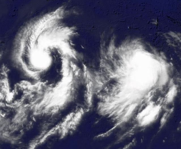
Typhoon Nakri
Typhoon Nakri was swirling in the western Pacific Ocean as a powerful Category 4 storm when the Moderate Resolution Imaging Spectroradiometer (MODIS) on NASA’s Terra satellite viewed it on May 29, 2008. The storm had sustained wind speeds of 230 kilometers per hour (145 miles per hour), making it a Super Typhoon, according to the University of Hawaii’s Tropical Storm Information Center.
MODIS shows the storm with a clear, but irregularly shaped eye, which is not expected to hold together, lessening the power of the storm. As of May 29, the Joint Typhoon Warning Center was projecting that the super typhoon would not maintain its strength for long. High-altitude winds were projected to pull the storm apart, and cooler sea surface temperatures were expected in its path. The typhoon was well away from most land, and forecasters were not expecting it to make landfall.
99A.INVEST kon weleens gaan uitgroeien tot Tropische Storm of meer.
De storm is nu 30kts (55km/uur) en bevindt zich in de Indische Oceaan
De storm is nu 30kts (55km/uur) en bevindt zich in de Indische Oceaan

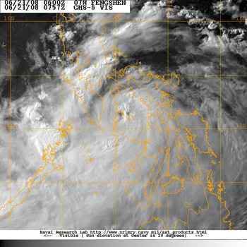
quote:Tyfoon Fengshen bij Fillipijnen
Vandaag raast de Tyfoon Fengshen over de Fillipijnen en er wordt verwacht dat deze zich morgen ook nog boven de Fillipijnen bevindt.
Er werd eerder verwacht dat de Tropische storm Fengshen de Fillipijnen zou vermijden. Maar Fengshen bevindt zich dan toch vandaag boven De Fillipijnen. Deze zorgt daar heftige regenval op de eilanden, die mogelijk tot overstromingen of modderstromen gaan leiden, afhankelijk van hoelang de storm over de eilanden raast.
Inmiddels heeft de storm windsnelheden van 128.7 km/u met windstoten van 152.9 km/u en is dus uitgegroeid tot een Tyfoon van categorie 1. Er wordt verwacht dat de Tyfoon naar een noordoostelijke richting afbuigt richting Japan. Zondagochtend bereikt de Tyfoon mogelijk windsnelheden van 150-177 km/u(categorie 2), maar gelukkig bevindt de Tyfoon zich, volgens de voorspellingen, dan boven zee)Fillipijnen-zee. Wel moeten boten en schepen voor hoge golven oppassen die zijn ontstaan als gevolg van de hoge windsnelheden.

http://weernieuws.weeronl(...)j_fillipijnen/8/2220
Op zaterdag 15 augustus 2009 23:05 schreef eer-ik het volgende:
Ik vind je sig nogal denigrerend.
Ik vind je sig nogal denigrerend.
Tyfoon Filipijnen eist zeker 12 levensquote:Tyfoon Filipijnen eist zeker 12 levens
Op de Filipijnen zijn zeker twaalf doden gevallen bij de doortocht van tyfoon Fengshen. Duizenden mensen zijn op de vlucht geslagen voor overstromingen en aardverschuivingen.
Bij de overstroming van de rivier de Risao, in de zuidelijke provincie Maquindanao, zijn tien mensen verdronken en worden nog acht anderen vermist. In het zuiden van het land zijn twee mensen om het leven gekomen bij aardverschuivingen, ook worden er nog vier personen vermist.
De tyfoon trok gisteren over naar het noordoosten van de Filipijnen met windsnelheden van 140 kilometer per uur. Er zijn meer dan 200.000 mensen geëvacueerd.
Op zaterdag 15 augustus 2009 23:05 schreef eer-ik het volgende:
Ik vind je sig nogal denigrerend.
Ik vind je sig nogal denigrerend.
Doden en geëvacueerden door tyfoon Filipijnen
MANILLA - Zeker veertien mensen zijn op de Filipijnen om het leven gekomen door overstromingen en aardverschuivingen na de tyfoon Fensghen.
Tyfoon Filipijnen
In de provincie Iloilo in het midden van het land zijn 30.000 mensen naar de daken van hun huizen gevlucht.
De burgemeester van de stad Iloilo zei dat de mensen zaterdag naar de daken vluchtten, nadat door toedoen van Fensghen een dam was bezweken. Hulpverleners vrezen dat door de overstroming na het breken van de dam veel mensen zijn omgekomen.
Maguindanao
In de zuidelijke provincie Maguindanao trad de rivier Upi buiten zijn oevers. Tien mensen verdronken, aldus een legerwoordvoerder. Acht mensen worden vermist.
Modderlawine
In de zuidelijke stad Cotabato vielen twee doden door een modderlawine. Op het eiland Negros vielen ook twee doden door het noodweer.
nu.nl (c) ANP
Veerboot zinkt voor kust Filipijnen
Voor de kust van de Filipijnen is een veerboot door de orkaan Fengshen in de problemen geraakt. De autoriteiten zeggen dat het schip met ongeveer 700 mensen aan boord bijna is gezonken.
Inmiddels zouden er zeker vier doden uit het water zijn gehaald. Volgens de autoriteiten sprongen de passagiers in rubberboten, nadat de kapitein het schip had verlaten. Door de hoge golven is het voor de kustwacht moeilijk om de veerboot te bereiken.
Door Fengshen, een orkaan van de laagste categorie, zijn op de Filipijnen zeker 59 mensen om het leven gekomen. Fengshen is nu op weg naar Taiwan.
nos
Veerboot zinkt voor Filipijnse kust
Honderden doden door tyfoon Filipijnen
MANILLA - Honderden mensen zijn op de Filipijnen om het leven gekomen door de zware tyfoon Fengshen. Het Rode Kruis van de Aziatische eilandengroep in de Grote Oceaan sprak zondag over 229 bevestigde slachtoffers.
Honderden opvarenden van een gekapseisde veerboot worden vermist. Media spreken over de grootste natuurramp ooit in het land.
De meeste doden op land vielen door overstromingen en aardverschuivingen als gevolg van de wervelwind, die windsnelheden van ruim 170 kilometer bereikte. Omvangrijke gebieden kwamen blank te staan, duizenden huizen werden vernield. Honderdduizenden inwoners raakten dakloos.
Regio
Een functionaris van het Rode Kruis zei dat alleen al in de regio Iloilo op het centraal gelegen eiland Panay 101 mensen zijn omgekomen. Ongeveer 30.000 mensen werden geëvacueerd. Zondag zakte het water. Daardoor konden voertuigen gebieden bereiken die eerder waren overstroomd.
In Iloilo en aangrenzende districten is de elektriciteit uitgevallen. Ook de telefoonverbindingen werken niet meer. Bestuurders zeiden dat het nog wel een week zal duren voordat de bevolking weer over stroom kan beschikken.
Overlevenden
Reddingwerkers hadden tot zondagavond vier overlevenden gevonden van de ramp met de veerboot Princess of the Stars die zaterdag voor de kust van de Filipijnen zonk als gevolg van de tyfoon.
De meesten van de ongeveer zevenhonderd passagiers en 120 bemanningsleden werden nog vermist. Zes lichamen van opvarenden zijn aangespoeld.
Golven
Het schip raakte in de problemen door enorme golven. De Princess of the Stars zond zaterdagavond een noodsignaal uit. Reddingwerkers zagen een gat in de romp van het half gezonken schip.
De Filipijnse president Gloria Arroyo eist opheldering over de omstandigheden waaronder de veerboot uitvoer. Ze wil weten waarom de Princess of the Stars vrijdag uit Manilla mocht vertrekken, toen de tyfoon al delen van het land teisterde.
nu.nl
http://www.nzherald.co.nz/category/story.cfm?c_id=68&objectid=10517717quote:China tornado wrecks 650 homes, kills one
2:45PM Sunday June 22, 2008
BEIJING - A tornado in China tore up 650 houses in just five minutes and damaged nearly 1000, state media said on Sunday, but only one person died.
The tornado touched down in the eastern province of Anhui on Saturday, causing 18.5 million yuan ($3.6 million) in losses.
Forty-five people, including eight seriously wounded, were taken to hospital after the tornado hit in Lingbi county, Xinhua news agency said.
One 76-year-old villager died on the way to hospital.
More than 20,000 people were "affected" by the tornado and 950 were relocated, Xinhua said.
Op zaterdag 15 augustus 2009 23:05 schreef eer-ik het volgende:
Ik vind je sig nogal denigrerend.
Ik vind je sig nogal denigrerend.

Een tornado is iets anders dan een orkaan.quote:Op maandag 23 juni 2008 11:50 schreef OA het volgende:
[..]
http://www.nzherald.co.nz/category/story.cfm?c_id=68&objectid=10517717
En dit is tenslotte het orkanen topic.

Heb ik vaker fout gedaan...quote:Op maandag 23 juni 2008 18:07 schreef aloa het volgende:
[..]
Een tornado is iets anders dan een orkaan.
En dit is tenslotte het orkanen topic.
Op zaterdag 15 augustus 2009 23:05 schreef eer-ik het volgende:
Ik vind je sig nogal denigrerend.
Ik vind je sig nogal denigrerend.
PHILIPPINES: Typhoon Fengshen death toll rises to 224
reuters
MANILA, 23 June 2008 (IRIN) - Typhoon Fengshen moved out of the Philippines on 23 June towards China, leaving at least 224 dead, hundreds missing and thousands homeless, according to the Philippine National Red Cross and Office of Civil Defence. Heavy rains and winds of up to 195km an hour caused landslides, flash floods and storm surges.
The number of fatalities exludes the passengers and crew of the MV Princess of Stars, which sank off Romblon Island in the Visayas. The ferry, bound for Cebu Island, Central Visayas, was carrying more than 800 people. Four bodies were washed ashore, while about 30 survivors were found. The rest remain unaccounted for, according to National Disaster Coordinating Council (NDCC) spokesman Anthony Golez.
"Our priority now is the relief and rescue operations for the victims of the typhoon, including those who are in the sunken ship," Golez told IRIN.
The island region of Western Visayas was worst hit and is the priority area for relief and rescue operations, Golez said.
"Last Saturday and Sunday [21 and 22 June], the province was one big sea," said Governor Sally Perez of Antique province in Western Visayas, where 34 people were found dead and 70 are still missing. Perez is the chief of the provincial disaster coordinating council.
In other areas, the water was reportedly as high as a double-storey house. In Iloilo, Western Visayas, about 30,000 residents reportedly climbed on to rooftops to flee the rushing water from an overflowing dam.
Aerial assessment
Golez said the government flew two C-130 planes to the area on 23 June to assess the damage and provide relief supplies. The strong winds had prevented the earlier delivery of goods by helicopter. Authorities say that only after the aerial assessment would they know the full extent of the damage.
"The priority is feeding our hungry people," Perez told IRIN. She added that they did not have sufficient clothing or medicines.
"We need drinking water, rice, noodles, blankets, and clothes," added Iloilo Congressman Raul Gonzalez Jr. "At the height of the typhoon on Saturday [21 June], the local government began distributing rice but it was spoiled by the torrential rain before it could be delivered by truck. Even the National Food Authority warehouse [where government-distributed rice is kept] was under water."
Many other areas of the country were under water. Typhoon Fengshen passed over central Luzon - the "rice granary" of the Philippines - on its way out of the country. Several provinces in the region were still submerged on 23 June, and fatal flash floods and landslides were reported in several parts of Mindanao on 21 June.
The Department of Agriculture reported that damage to crops had reached nearly P555 million (US$12.6 million), affecting an estimated 246,000 hectares of rice farms.
Antique province alone estimated a loss of P100 million, said Perez. "About 2,000 hectares of agricultural land is now unusable," she said.
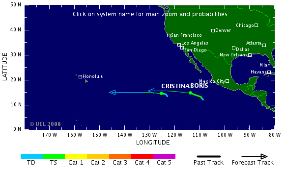
Boris & Cristina
In the eastern Pacific, Tropical Storm Cristina (40 mph) is weakening and Tropical Storm Boris (70 mph) may briefly flare to minimal hurricane strength before beginning to weaken as they both continue to move westward far away from land.
Boris is located about 735 miles southwest of Cabo San Lucas, Mexico; Cristina is centered roughly 1345 miles west-southwest of Cabo San Lucas.
Both storms are forecast to weaken as they edge westward.
A broad area of disturbed weather several hundred miles south of the Gulf of Tehuantepec could develop slowly as it moves west-northwestward over the next several days.
In the Atlantic Basin, there are no areas of concern.
bron
Douglas off western Mexican Coast
Boris
Boris has weakened back to a tropical storm tonight. Boris is centered about 1235 miles west-southwest of Cabo San Lucas, Mexico, and is forecast to move slowly westward and weaken with time.
Meanwhile, Tropical Storm Douglas (40 mph) has been christened off the west coast of Mexico. The storm, moving toward the northwest, is located about 345 miles south-southeast of Cabo San Lucas, and is forecast to strengthen slowly over the next 24 hours.
No warnings or watches have been posted along the Mexican west coast, but heavy rain associated with Douglas could affect areas between Lazaro Cardenas and Puerto Vallarta tonight.
The forecast calls for Douglas to parallel the coast as it moves up toward the Baja. All interests in the Southern Baja and mariners off the west coast will need to monitor Douglas closely the next several days.
In the eastern Atlantic, a well defined low pressure center is located about 330 miles southeast of the Cape Verde Islands and is swirling toward the west. Environmental conditions appear favorable for slow development of this disturbance, and it could become a tropical depression within the next day or two as it continues westward. Development in this area is rare, but not unprecedented, at this time of year.
Boris

Boris has weakened back to a tropical storm tonight. Boris is centered about 1235 miles west-southwest of Cabo San Lucas, Mexico, and is forecast to move slowly westward and weaken with time.
Meanwhile, Tropical Storm Douglas (40 mph) has been christened off the west coast of Mexico. The storm, moving toward the northwest, is located about 345 miles south-southeast of Cabo San Lucas, and is forecast to strengthen slowly over the next 24 hours.
No warnings or watches have been posted along the Mexican west coast, but heavy rain associated with Douglas could affect areas between Lazaro Cardenas and Puerto Vallarta tonight.
The forecast calls for Douglas to parallel the coast as it moves up toward the Baja. All interests in the Southern Baja and mariners off the west coast will need to monitor Douglas closely the next several days.
In the eastern Atlantic, a well defined low pressure center is located about 330 miles southeast of the Cape Verde Islands and is swirling toward the west. Environmental conditions appear favorable for slow development of this disturbance, and it could become a tropical depression within the next day or two as it continues westward. Development in this area is rare, but not unprecedented, at this time of year.
Toekomstig Tropical Storm Bertha in de Atlantische Oceaan.
T.D. 2 forms in the Atlantic
Tropical Depression 2 (winds 35 mph) has formed 250 miles SSE of the Cape Verde Islands in the far eastern Atlantic. It is forecast to become Tropical Storm Bertha later today as it moves toward the west-northwest.
Also in the Atlantic, an area of showers and thunderstorms is moving through the Windward Islands with some gusty winds and locally heavy rain.
Meanwhile in the eastern Pacific, minimal Tropical Storm Douglas (40 mph), located about 230 miles south of Cabo San Lucas, will likely weaken to a tropical depression later today as its movement turns more westerly.
Tropical Storm Boris, also in the eastern Pacific and located 1270 miles west-southwest of Cabo San Lucas, Mexico, will continue to weaken and could become a tropical depression by tonight as its movement turns west-southwestward.
Na een tijdje nauwelijks tropische stormen of orkanen, begint het ineens tot leven te komen.
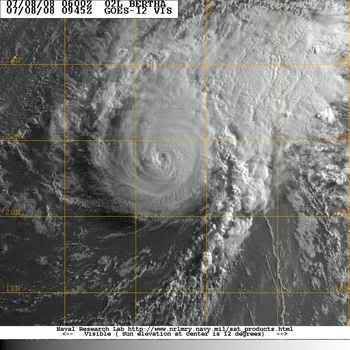
Tropische Storm Bertha bij de Kaapverdische eilanden
Tropische Storm Bertha bij de Kaapverdische eilanden

Komt er nog een herhaling vanquote:Op vrijdag 4 juli 2008 23:00 schreef Frutsel het volgende:
Gisteravond indrukwekkende docu over Nargis op National Geo
Orkaan Bertha is een feit (cat. 1). Waarschijnlijk komt ze niet aan land. Ben benieuwd wat we dit jaar te verwerken krijgen aan orkanen (woon in Cancun en werk op de Caribische eilanden)  Eén ding weet ik wel, ik ga NIET in mijn huis schuilen als er een orkaan komt. Ik woon in een hoog, erg smal gebouw zonder buren naast me (alleen boven en onder). Dat vertrouw ik niet, dus ik heb al afgesproken met een vriendin dat ik bij haar en haar familie ga schuilen

Bertha is een categorie3 geworden.
"Major" Hurricane Bertha
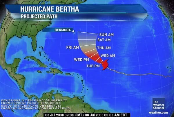
Hurricane Bertha (120 mph) intensified rapidly on Monday.
Bertha, as of 5 a.m. EDT, was centered about 1035 miles SE of Bermuda and moving toward the NW at 10 mph.
The hurricane may grow in size as it moves to higher latitudes.
It still appears as if Bertha will eventually take a more northerly course and miss the East Coast of the U.S. Bermuda, however, could be threatened. Residents of the island are advised to pay close attention to the hurricane's progress.
"Major" Hurricane Bertha
Hurricane Bertha (120 mph) intensified rapidly on Monday.
Bertha, as of 5 a.m. EDT, was centered about 1035 miles SE of Bermuda and moving toward the NW at 10 mph.
The hurricane may grow in size as it moves to higher latitudes.
It still appears as if Bertha will eventually take a more northerly course and miss the East Coast of the U.S. Bermuda, however, could be threatened. Residents of the island are advised to pay close attention to the hurricane's progress.
Wow. Dat was nou niet echt voorzien, geloof ik. Bewijst maar weer dat we nog geen donder van die dingen snappen.
Two named storms
Category 1 Hurricane Bertha (winds of 80 mph) is centered about 215 miles southeast of Bermuda, creeping northward at around 2 miles per hour. This very slow movement will continue into Monday. Then Bertha's track should gradually veer northeastward and then eastward with steady weakening.
Bermuda is experiencing high surf on the order of 16 to 22 feet along south and southeast facing beaches. Increased surf is also impacting the East Coast of the United States, especially now from the Outer Banks northward, with 3 to 7 foot waves. Dangerous rip currents are also occurring.
In the eastern Pacific, Tropical Storm Elida has formed, located 270 miles south-southeast of Acapulco, Mexico. It is currently moving west northwest, away for the western Mexico Coast; little impact to land is expected.
An area of low pressure was also located about 200 miles south of Cabo San Lucas, Mexico. It is possible this could develop into a tropical depression, as it moves slowly off to the west.
Bertha weakened from a hurricane to a tropical storm Sunday as it hovered near Bermuda. Forecasters say it might still deal a glancing blow to the Atlantic island.
Bertha's outer bands were expected to brush the island in the coming days.
Over the weekend, most tourists chose to hang out in pools and walk along the beach instead of battle the storm-whipped surf and rip currents along Bermuda's southern coast. Signs were posted announcing that beaches are closed.
"You can go out and swim if you like, but lifeguards will not come out and get you," said Darnell Joell, a bartender at Coco Reef resort.
Lifeguards at Horseshoe Beach blocked the shoreline with bright red tape and turned tourists away. Many lingered, however, taking pictures of the crashing waves.
The U.S. National Hurricane Center said the storm's maximum sustained winds decreased to near 65 miles per hour. Bertha was centered about about 180 miles southeast of Bermuda.
The center said Bertha was moving northwest at about 2 miles per hour. The center of the storm is expected to pass slowly not far to the southeast and east of Bermuda, dumping 2-4 inches of rain on the island. The center's hurricane tracking map showed Bertha sideswiping Bermuda on Monday, a day later than earlier forecasts.
Many tourists were largely unconcerned.
"It's not really going to hit that hard," said Eilif Kenny, 21, who was visiting from Ireland. "If it was ... I'd be under the bed."
Bertha became the Atlantic season's first hurricane on July 7 and has vacillated between a Category 1 and 2 storm.
Meanwhile, Tropical Storm Elida swirled off Mexico's Pacific coast, about 250 miles southwest of Acapulco.
The hurricane center said Elida was headed farther out to sea. It had sustained winds of nearly 65 mph on Sunday morning and was traveling west-northwest at 16 mph.
cnn

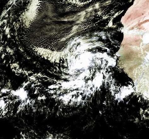
Hurricane Bertha
Tropical Storm Bertha swept past Bermuda on July 14, 2008. The storm system had fallen from hurricane strength, but it still packed winds of 100 kilometers per hour (55 miles per hour) around the storm center. The island of Bermuda is no stranger to severe storms, and had battened down in preparation. There were widespread power outages, but no serious damage or injuries were reported, according to the Associated Press on July 15. Rip tides and surf were unusually strong not only in Bermuda, but along much of the east coast of the United States, due to the winds and waves from the storm system.
This natural-color satellite image, obtained by the Moderate Resolution Imaging Spectroradiometer (MODIS) on NASA’s Terra satellite shows Tropical Storm Bertha as it appeared at 12:05 p.m. local time (15:05 UTC) on July 14, 2008. The storm system shows the hallmark spiral shape of a tropical storm system and remnants of a central eye, but its appearance was more ragged than a well-formed hurricane. As of July 15, forecasters at the National Hurricane Center were anticipating that the storm system would move away from Bermuda and rebuild in strength slightly to reach Category 1 hurricane status once again.
Momenteel zijn er 4 systemen aktief, waarvan Tropical cyclone KALMAEGI het meeste gevaar oplevert.
Kans is groot dat er zich eerdaags weer een storm in de Atlantische Oceaan ontwikkeld.
Kans is groot dat er zich eerdaags weer een storm in de Atlantische Oceaan ontwikkeld.
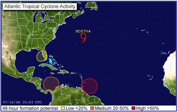
Ligt het aan mij of lijkt het ook ten zuiden van Cuba en zuidwesten van de Dominicaanse republiek te broeien?
Het kon inderdaad weleens druk gaan worden in de Caribbean.quote:Op donderdag 17 juli 2008 09:48 schreef Frutsel het volgende:
[ afbeelding ]
Ligt het aan mij of lijkt het ook ten zuiden van Cuba en zuidwesten van de Dominicaanse republiek te broeien?

Fausto en Elida gaan langs elkaar, die moeten gewoon mergen tot een 'superstorm'
BTW: Onderste lijn is Fausto, bovenste is Elida
Bertha schrijft geschiedenis
De tropische storm Bertha gaat de geschiedenis in als het langstlevende systeem op de Atlantische Oceaan in juli.
Bertha die op 3 juli ontstond voor de kust van Afrika leeft alweer 14 dagen en versloeg daarmee “storm nummer 2” uit 1916. Dit systeem leefde 12 dagen. Het systeem trekt naar IJsland, waar het de komende week voor storm zal zorgen. Tegelijkertijd wordt er dan warmte uit het zuiden onze richting opgestuwd.
Bertha heeft toch nog indirect voor één dode gezorgd. Langs de oostkust van de Verenigde Staten kwamen gevaarlijke stromingen voor, waarbij één persoon verdronk.
vwk
Die dikke Bertha gaat ons weer nog behoorlijk op de schop gooien volgende weekquote:Op donderdag 17 juli 2008 22:33 schreef aloa het volgende:
Bertha schrijft geschiedenis
De tropische storm Bertha gaat de geschiedenis in als het langstlevende systeem op de Atlantische Oceaan in juli.
Bertha die op 3 juli ontstond voor de kust van Afrika leeft alweer 14 dagen en versloeg daarmee “storm nummer 2” uit 1916. Dit systeem leefde 12 dagen. Het systeem trekt naar IJsland, waar het de komende week voor storm zal zorgen. Tegelijkertijd wordt er dan warmte uit het zuiden onze richting opgestuwd.
Bertha heeft toch nog indirect voor één dode gezorgd. Langs de oostkust van de Verenigde Staten kwamen gevaarlijke stromingen voor, waarbij één persoon verdronk.
vwk
* I intend to live forever, so far so good! *
Hurricane Isabel heeft het langer volgehouden dacht ik toch...
Drie weken
http://www.hurricaneville.com/isabel.html
Drie weken
http://www.hurricaneville.com/isabel.html
A tropical storm lashed Taiwan on Friday, killing at least seven people, an emergency official told CNN.
Another six were hurt and six more were missing, according to the official at the island's Central Response Center.
The missing included a husband and wife who were swept away by fast-rising creek water, officials said.
Tropical Storm Kalmaegi dumped heavy rain on central and southern Taiwan, causing problems in places such as Taichung, a city in central Taiwan.
The eye of the storm left Taiwan on Friday, but storm clouds lingered, and forecasters warned of heavy rain and the possibility of mudslides in central and southern regions of the island, particularly in mountainous areas.
Flooding was reported in many low-lying areas, particularly in southern Taiwan, according to the island's Central News Agency. It published a photo of knee-deep water on a highway in Kaohsiung County. Flood waters rose to the height of two stories in one city, officials said.
Officials said that water was cut off from more than 650,000 households because of flooding in Tainan county, also in southern Taiwan, The Associated Press reported. Watch how high the flooding reaches »
Forecasters expect the storm to hit coastal areas of southeastern China late Friday, prompting authorities to plan for possible flooding in Zhejiang and Fujian provinces, according to China's state-run Xinhua news agency.
Boats and ships from those provinces have been ordered back to port, the agency said.
CHARLESTON, S.C. — A storm off the Southeast coast that sent bands of rain into Georgia and South Carolina developed into a tropical depression late Friday night, the National Hurricane Center said.
The hurricane center issued a tropical storm warning from South Santee River, S.C., to the North Carolina/Virginia border, including Pamlico Sound. That means tropical storm conditions are expected within the warning area within the next 24 hours.
A tropical storm watch was issued from north of Edisto Beach, S.C., to South Santee River, and from north of Cape Hatteras to Oregon Inlet, meaning tropical storm conditions are possible within the watch area, generally within 36 hours.
At 11 p.m., the center of the tropical depression about 45 miles southeast of Charleston and about 295 miles southwest of Cape Hatteras. Movement was to the northeast at about 5 mph, and the hurricane center expected the storm to continue that movement for the next two days, keeping the storm close to the coast.
Maximum sustained winds were near 30 mph with higher gusts. Forecasters called for some strengthening in the next 24 hours, and said the depression could become a tropical storm on Saturday.
Meteorologist Jonathan Lamb of the National Weather Service in Charleston said most of the rain remained offshore and, even if the storm deepened, it would not cause too many problems.
"Even if it did develop and stayed off the coast, the impacts on the Charleston and Savannah areas would be relatively low," he said. "It wouldn't be anything near a hurricane or anything like that."
He said the storm could bring occasional showers and thundershowers, some heavy at times.
A tropical depression has winds of 38 mph or less. It becomes a tropical storm with winds sustained at 39 mph.
If the system develops into a tropical storm, it would be named Cristobal, the third named in the 2008 Atlantic Hurricane season.
Zo, over een weekje zit ik in het vliegtuig naar de Filippijnen.... Midden in Typhoonseizoen (wat een timing!!!)
Hopelijk gebeurt er niets, maar blijf er een maand.
Héél misschien ooggetuigeverslag... als ik zin heb om een internetcafé in te duiken én als er wat gebeurd.
links:
www.typhoon2000.com
www.pagasa.dost.gov.ph
Hopelijk gebeurt er niets, maar blijf er een maand.
Héél misschien ooggetuigeverslag... als ik zin heb om een internetcafé in te duiken én als er wat gebeurd.
links:
www.typhoon2000.com
www.pagasa.dost.gov.ph
Ik ben een eckte rapnegert
Mooie beelden van Fausto trouwens:
http://satelliet.weeronline.nl/midden_amerika/mexico/97
[ Bericht 28% gewijzigd door Gummibeer79 op 20-07-2008 15:33:28 ]
http://satelliet.weeronline.nl/midden_amerika/mexico/97
[ Bericht 28% gewijzigd door Gummibeer79 op 20-07-2008 15:33:28 ]
Ik ben een eckte rapnegert