WKN Weer, Klimaat en Natuurrampen
Lees alles over het onstuimige weer op onze planeet, volg orkanen en tornado's, zie hoe vulkanen uitbarsten en hoe Moeder Aarde beeft bij een aardbeving. Alles over de verwoestende kracht van onze planeet en tal van andere natuurverschijnselen.


quote:Tropical Storm Josephine
The outer bands of Tropical Storm Josephine cover the Cape Verde Islands off the west coast of Africa in this photo-like image captured on September 4, 2008. The Moderate Resolution Imaging Spectroradiometer (MODIS) on NASA’s Terra satellite captured the image at 11:20 a.m. local time (12:20 UTC). At that time, the storm had winds estimated between 83 and 93 km/hr (52 and 58 mph or 45 and 50 knots). The weak storm consists of loose bands of clouds roughly arranged in a circular shape in this image. Josephine was forecast to weaken slightly as it moved west across the Atlantic Ocean.

quote:Hurricane Ike
A hurricane’s structure is visible not only in its clouds in photo-like images, but also in its rainfield. This image, captured by the Tropical Rainfall Measuring Mission (TRMM) satellite on September 4, 2008, at 7:35 a.m. EDT, shows rainfall in Hurricane Ike. At the time, the storm was a dangerous Category 4 hurricane with sustained winds estimated at 230 kilometers per hour (144 miles per hour or 125 knots), according to the National Hurricane Center. A complete ring of rain circles a calm eye. Additional bands of heavy rain spiral out from the center of the storm. Ike was moving west over the Atlantic towards the Bahamas.
TRMM is a joint mission between NASA and the Japan Aerospace Exploration Agency (JAXA) designed to monitor and study tropical rainfall.


quote:Hurricane Hanna
Tropical Storm Hanna continued to plow through the Caribbean Sea on September 2, 2008, bringing strong surf and heavy rains to the island of Hispaniola (home to Haiti and the Dominican Republic) before heading to the Bahamas. This image of the storm was captured by the Moderate Resolution Imaging Spectroradiometer (MODIS) on NASA’s Aqua satellite. The storm was ragged and sprawling, with no distinct eye. The center of circulation was evident in the bright ball of clouds north of Hispaniola, however. Forecasts as of September 3 were uncertain as to whether the storm would regain hurricane status in coming days.
The high-resolution image provided above is at MODIS’ full spatial resolution (level of detail) of 250 meters per pixel. The MODIS Rapid Response System provides this image at additional resolutions.


Ike komt wel erg dicht hier in de buurt. Als ik de lijn een beetje doortrek, dan komt ie volgende week vrijdag hier in de buurt aan land.
Een van de enge dingen die Ike zou kunnen doen, is een eind langs de kust van de vs trekken, en zo een behoorlijk hoge storm surge creeeren. De forecast van Ike lijkt een stuk meer op Katrina dan Gustav deed.
Hoewel de kans natuurlijk niet zo groot is dat Ike ook landfall in Louisiana zou maken.
Hoewel de kans natuurlijk niet zo groot is dat Ike ook landfall in Louisiana zou maken.
blijft veel boven zee, dat steeds warmer wordt, dan kan het een knoeper worden....quote:Op vrijdag 5 september 2008 17:56 schreef Co_OL het volgende:
Update ziet er niet goed uit Ike!
[ afbeelding ]
[b]Op maandag 6 september 2010 00:28 schreef tong80 het volgende:[/b]
GVD Wat moet jij een trotse vader zijn :)
:P
GVD Wat moet jij een trotse vader zijn :)
:P

Precies waar ik aan dacht met de laatste update.....quote:Op vrijdag 5 september 2008 20:47 schreef thijsdetweede het volgende:
Een van de enge dingen die Ike zou kunnen doen, is een eind langs de kust van de vs trekken, en zo een behoorlijk hoge storm surge creeeren. De forecast van Ike lijkt een stuk meer op Katrina dan Gustav deed.
Hoewel de kans natuurlijk niet zo groot is dat Ike ook landfall in Louisiana zou maken.
Zie hoe groot die onzekerheid is, er is nog weinig van te zeggen op deze termijn. Sowieso is het een potentieel (zeer) gevaarlijke orkaan, maar waar ie aan land gaat is een coin flip.
Dat is dan weer goed nieuwsquote:
Ik ben tot een uur of 18 weg vandaag, als het topic dan vol is dan kunnen er twee topics gemaakt worden:
- Ike
- Hurricane Season 2008
Rond dat tijdstip kan ik dan kijken of er nog iets aan de OPs moet gebeuren.
- Ike
- Hurricane Season 2008
Rond dat tijdstip kan ik dan kijken of er nog iets aan de OPs moet gebeuren.

Straks krijg je misschien weer bericht voor evacuatie voor Ike in New Orleans die niemand dan meer serieus neemt door Gustav. En zal je zien dat het dan wel een voltreffer word. Zal de natuur echt zo gemeen zijn?
Aan mijn uitspraken kunnen geen rechten worden verleend. Echter wel ontleend (mits de theorie klopt).
Tegen de natuur kan je niks doen die gaat dr gang wel!quote:Op zaterdag 6 september 2008 10:43 schreef Flyduck het volgende:
Straks krijg je misschien weer bericht voor evacuatie voor Ike in New Orleans die niemand dan meer serieus neemt door Gustav. En zal je zien dat het dan wel een voltreffer word. Zal de natuur echt zo gemeen zijn?
Het ziet er wel erg gevaarlijk uit weer voor New Orleans :S

whehe,quote:Op zaterdag 6 september 2008 12:54 schreef Party_P het volgende:
[..]
Sorry maar we hebben al een Hanna in Europa
[ afbeelding ]
Maar, ik kijk er wel naar uit. Misschien nog iets meer naar het oosten zou nog leuker zijn.
Ik ben een eckte rapnegert

Tegen de tijd dat ie bij ierland is is of enorm afgezwakt of al geeneens een tropische storm meer te noemen.quote:Op zaterdag 6 september 2008 10:31 schreef Roel_Jewel het volgende:
[..]
Yup:
Afbeelding
Laat ik nou vanaf dinsdag in het westen van Ierland zitten. Wordt gezellig dus.
We zullen 't zienquote:Op zaterdag 6 september 2008 16:52 schreef Hertog_Martin het volgende:
[..]
Tegen de tijd dat ie bij ierland is is of enorm afgezwakt of al geeneens een tropische storm meer te noemen.
Tegen die tijd is Hanna zeker extra-tropical. Maar als het NHC over 5 dagen een "S" bij Ierland neerzet, verwachten ze wel dat er TS-achtige windsnelheden gemeten kunnen worden. Ongehoord is dat allemaal niet: Zo hadden we in fabeled 2005 orkaan Vince die landfall maakte in Spanje als tropische depressie, en komen er bijna ieder jaar wel remnant lows langs in Europa. Bertha nog, afgelopen juli.
Vorig jaar ook een vlak langs portugal. Kwestie van tijd voordat portugal er een aan land krijgt of is dta niet mogelijk vanwege dingen als zeetemperatuur daar?quote:Op zaterdag 6 september 2008 17:11 schreef thijsdetweede het volgende:
Tegen die tijd is Hanna zeker extra-tropical. Maar als het NHC over 5 dagen een "S" bij Ierland neerzet, verwachten ze wel dat er TS-achtige windsnelheden gemeten kunnen worden. Ongehoord is dat allemaal niet: Zo hadden we in fabeled 2005 orkaan Vince die landfall maakte in Spanje als tropische depressie, en komen er bijna ieder jaar wel remnant lows langs in Europa. Bertha nog, afgelopen juli.
Vince bewijst dat het mogelijk zou kunnen zijn 
Maar 2005 was wel heel bijzonder, en bij Vince snapten de heren van het NHC er ook weinig van. Een beetje een freak storm.
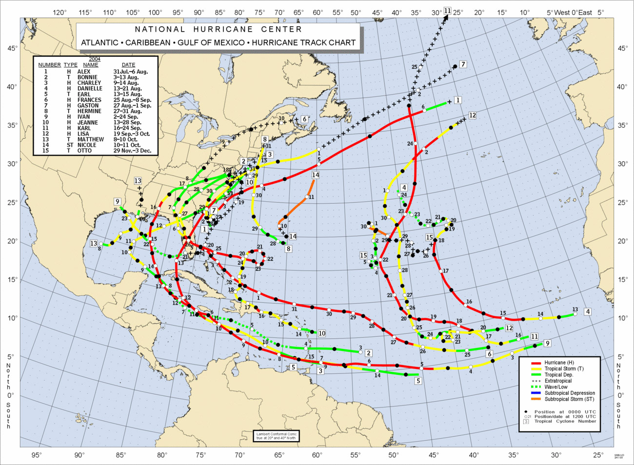
De zaken die tegen een serieuze orkaan op Iberia spreken zijn sowieso de zeewatertemperatuur, maar ook de algehele atmosferische stroming: Vanaf Afrika naar het westen, langs de oostkust van de VS met de golfstroom naar boven, en met de straalstroom weer naar Europa. Eventueel nog naar het zuiden van Europa naar Afrika. Zo'n orkaan zou dus eigenlijk de hele tijd tegen de wind in moeten knokken. Een plaatje van de stormtracks van 2004:
Maar 2005 was wel heel bijzonder, en bij Vince snapten de heren van het NHC er ook weinig van. Een beetje een freak storm.
De zaken die tegen een serieuze orkaan op Iberia spreken zijn sowieso de zeewatertemperatuur, maar ook de algehele atmosferische stroming: Vanaf Afrika naar het westen, langs de oostkust van de VS met de golfstroom naar boven, en met de straalstroom weer naar Europa. Eventueel nog naar het zuiden van Europa naar Afrika. Zo'n orkaan zou dus eigenlijk de hele tijd tegen de wind in moeten knokken. Een plaatje van de stormtracks van 2004: