WKN Weer, Klimaat en Natuurrampen
Lees alles over het onstuimige weer op onze planeet, volg orkanen en tornado's, zie hoe vulkanen uitbarsten en hoe Moeder Aarde beeft bij een aardbeving. Alles over de verwoestende kracht van onze planeet en tal van andere natuurverschijnselen.


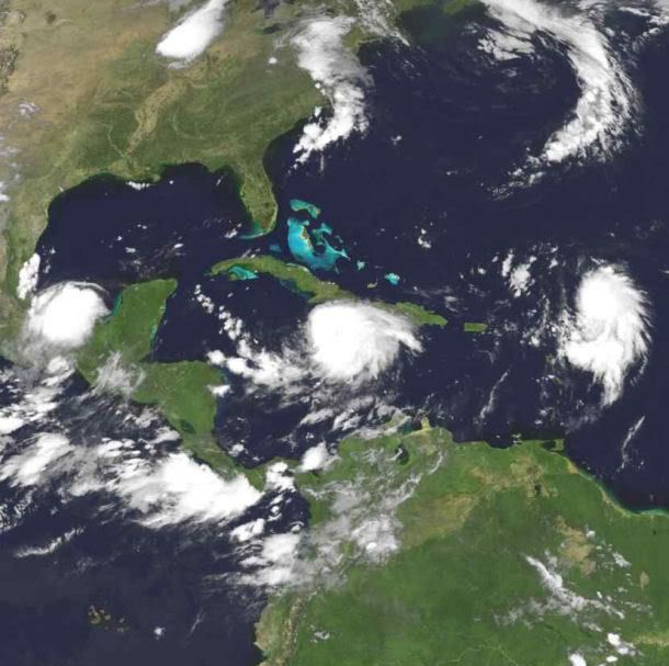
Klopt, maar je ziet ook wel dat ze het als cat.3 inschalen maar het warme zeewater doet ineens beter zijn best... voor je het weet wordt het toch een cat.4 en gaat ie als 3 aan land... en New Orleans loopt denk ik al onder bij een Cat 1quote:Op woensdag 27 augustus 2008 09:42 schreef Drugshond het volgende:
[..]
Zal wel loslopen..... vlak voor het aan land gaan zakt het bijna altijd 2 schalen down.
Van C3 naar C1...
Katrina was boven de golf van Mexico een dikke C5+ (Rita was zelfs nog sterker). Maar boven land was het een dikke C2/C3.
Ben benieuwd... maar qua trajectorie en kracht is nog te veel onduidelijk.quote:Op woensdag 27 augustus 2008 09:54 schreef Frutsel het volgende:
[..]
Klopt, maar je ziet ook wel dat ze het als cat.3 inschalen maar het warme zeewater doet ineens beter zijn best... voor je het weet wordt het toch een cat.4 en gaat ie als 3 aan land... en New Orleans loopt denk ik al onder bij een Cat 1Die zijn nog altijd niet hersteld
Fay floods Florida
Tropical Storm Fay spent six days zig-zagging across Florida and dumping heavy rain on the entire state between August 19 and August 24, 2008. By August 25, when the Moderate Resolution Imaging Spectroradiometer (MODIS) on NASA’s Terra satellite captured the top image, floods inundated much of Florida. The worst of the flooding was along the St. Johns River in central Florida, which reached 10.95 feet near Lake Harney on August 26 and water levels were still rising, said the National Weather Service. The river floods when water levels reach 8.5 feet.
Too small to be visible the previous month, the swollen river paints a wide black ribbon down the bright green plant-covered landscape in the top image. Tiny clouds, pale blue and white in this type of image, dot the skies in both images. The large image, which includes a broader area, shows additional flooding around Lake Okeechobee.
The St. Johns River lines the east coast of Florida near Cape Canaveral, home to NASA’s Kennedy Space Center. Tropical Storm Fay closed the center between August 19 and August 21, but caused only minor damage to the facilities and no damage to space hardware, according to initial assessments.
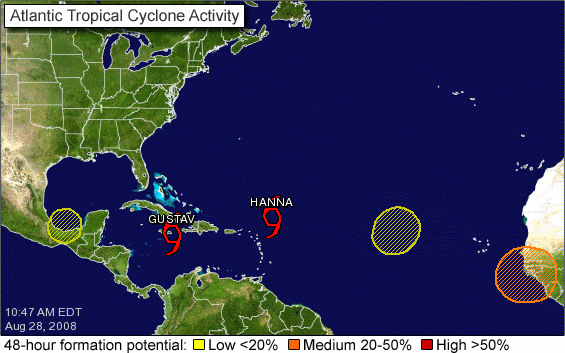
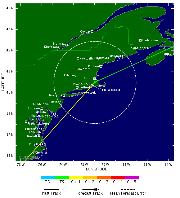
En de volgende storm, Hanna, staat op de kaart:

[b]Op maandag 6 september 2010 00:28 schreef tong80 het volgende:[/b]
GVD Wat moet jij een trotse vader zijn :)
:P
GVD Wat moet jij een trotse vader zijn :)
:P
Ja, en er zijn nog 3 andere systemen actief! Gustav vormt nog steeds een behoorlijk gevaar voor ons. Je merkt er desalniettemin niets van dat er een orkaan / TS in de buurt is, de zon schijnt en de lucht is blauw, as usual 
Hanna zou wel eens een fishspinner kunnen blijken, maar een dubbele penetratie van Florida zit duidelijk ook nog in de mogelijkheden.
Gustav is overigens vanochtend spontaan een stukje naar het zuiden versprongen. Zit de belhamel ineens net onder Jamaica.
Gustav is overigens vanochtend spontaan een stukje naar het zuiden versprongen. Zit de belhamel ineens net onder Jamaica.
quote:MIAMI — The National Hurricane Center says Tropical Storm Hanna has formed northeast of the northern Leeward Islands in the Atlantic.
The eighth tropical storm of the Atlantic season had top sustained winds near 40 mph Thursday. Its center was about 305 miles northeast of the northern Leeward Islands and was moving toward the west-northwest near 12 mph.
Hanna could produce rainfall of 1 to 4 inches across parts of the Leeward Islands. It's too soon to say if Hanna will affect the U.S.


1 to 4 inches is een flinke regenbui, niet meer.quote:Op vrijdag 29 augustus 2008 00:03 schreef Frutsel het volgende:
Hanna could produce rainfall of 1 to 4 inches across parts of the Leeward Islands. It's too soon to say if Hanna will affect the U.S.
http://www.foxnews.com/story/0,2933,411862,00.htmlquote:he National Guard was scheduled to begin convoying supplies and troops into New Orleans on Friday, while some nursing homes and hospitals planned to start moving patients further inland and the state began moving 9,000 inmates from coastal lockups.
An evacuation order for New Orleans was likely, Mayor Ray Nagin said, but not before Saturday Meanwhile, residents of areas further south could be told to leave starting Friday, Gov. Bobby Jindal said.
http://afp.google.com/article/ALeqM5h_pRg8PjsWyfviUQrPDgGKV_FnoQquote:NEW ORLEANS (AFP) — Authorities began busing people out of areas of New Orleans on Friday ahead of the possible landfall of Tropical Storm Gustav, forecast to hit the region as a powerful hurricane early Tuesday.
Officials in Saint Charles parish, in western New Orleans, have been busing out residents who want to leave the city.
While the Friday evacuations are voluntary, authorities in Saint Charles and the five other New Orleans parishes are planning mandatory evacuations starting noon Saturday if Gustav remains on the same path.
Parish officials "are extremely concerned about storm surge flooding" that Gustav would cause, noting that "the entire parish remains at risk.
"All residents should be taking steps to secure their homes and prepare for evacuation NOW," read a statement from the office of Parish President V.J. St. Pierre.
Dostojewski: "Je kunt je niet van je eigen gezond verstand overtuigen door je buurman op te sluiten."
quote:Gustav wordt orkaan
MIAMI - De tropische storm Gustav is in het Caribisch gebied boven zee in kracht toegenomen en tot een orkaan uitgegroeid. Dat heeft het Amerikaanse National Hurricane Center (NHC) vrijdag laten weten.
Uit observaties vanuit de lucht blijkt dat Gustav nu windsnelheden tot 120 kilometer per uur bereikt. Daarmee is hij een orkaan van de eerste en laagste categorie op de zogeheten Saffir-Simpsonschaal, die vijf schalen kent.
Gustav heeft inmiddels zeker 78 levens geëist en grote verwoestingen aangericht op Haïti, de Dominicaanse republiek en Jamaïca. De orkaan stevent vrijdag af op de Kaaimaneilanden en zal zaterdag het westen van Cuba bereiken.
Gebied
De Kaaimaneilanden is Brits overzees gebied en ligt op 800 kilometer van Florida en 300 kilometer van Jamaïca.
De 40.000 inwoners van het vakantie- en belastingparadijs hebben de luiken gesloten van woningen en resorts en blijven zoveel mogelijk binnen in afwachting van Gustav.
Derde categorie
Gustav zal naar verwachting een orkaan van de derde categorie zijn als hij waarschijnlijk dinsdag het Amerikaanse vasteland bereikt.
Dat meldden functionarissen van de Amerikaanse rampenbestrijdingsdienst FEMA vrijdag.
http://www.nola.com/hurri(...)sh_plans_lockdo.htmlquote:St. Bernard Parish plans "lockdown"
by Leslie Williams, The Times Picayune
Friday August 29, 2008, 8:35 PM
St. Bernard Parish President Craig Taffaro Jr. announced late Friday night that he plans to call a mandatory evacuation for his parish at 4 p.m. Saturday, which will be followed immediately by a "lockdown" to prevent anyone from entering the parish.
Anyone who does not comply with the mandatory evacuation will be required to remain in his or her house, he said.
Traveling within the parish will not be allowed. And anyone arrested for violating the multi-day curfew will be sent to Angola, not the parish prison, he said.
Only when the threat of Gustav has passed will anyone be allowed to return, beginning with first responders, Taffaro said.
Exceptions will occur for residents who may want to leave after the 4 p.m. deadline, but that's it, he said.
The mandatory evacuation will be called unless the storm "stalls out," Taffaro said. Residents are being ordered to leave "for their protection" from gale force winds, he said.
Bush en Cheney waren gepland maandagavond te spreken op de Republican National Convention.
maar waarschijnlijk laten ze zich niet zien daar, ook niet via de satelliet.

daar komt McCain dan goed vanaf op die manier.
Dostojewski: "Je kunt je niet van je eigen gezond verstand overtuigen door je buurman op te sluiten."
Huh, Angola het land in Afrika? Ik snap het niet volgens mij.quote:And anyone arrested for violating the multi-day curfew will be sent to Angola, not the parish prison, he said.
het is een gevangenis (state prison):
http://www.corrections.state.la.us/lsp/
vernoemd naar een plantage op die plek, en die slaven kwamen uit Angola.
http://www.corrections.state.la.us/lsp/
vernoemd naar een plantage op die plek, en die slaven kwamen uit Angola.
Dostojewski: "Je kunt je niet van je eigen gezond verstand overtuigen door je buurman op te sluiten."
die gevangenis ligt niet zo gek ver van de kust.
en aan drie kanten omgeven door de mississippi rivier, die toch al vaak overstroomt.
dus zo moeten wel een goed evacuatie-plan hebben voor het geval gustav daar precies langs komt.
de gevangenis in new orleans zelf wordt daar al naar toe ge-evacueerd, het zal al wel druk worden.
en aan drie kanten omgeven door de mississippi rivier, die toch al vaak overstroomt.
dus zo moeten wel een goed evacuatie-plan hebben voor het geval gustav daar precies langs komt.
de gevangenis in new orleans zelf wordt daar al naar toe ge-evacueerd, het zal al wel druk worden.
Dostojewski: "Je kunt je niet van je eigen gezond verstand overtuigen door je buurman op te sluiten."

NOS TTquote:***************************************
Gustav groeit naar categorie 4
***************************************
` Vanwege de naderende orkaan Gustav
heeft de Amerikaanse president Bush de
noodtoestand afgekondigd in Louisiana
en Texas.Daardoor kan de hulpverlening
vanuit Washington worden geregeld.
Bush wil voorkomen dat de hulpverlening
weer misloopt,zoals drie jaar geleden
toen Katrina het gebied rond New
Orleans trof.Langs de Golfkust vielen
toen 1800 doden.
Gustav is de afgelopen uren snel in
kracht toegenomen en het Hurricane
Centre heeft hem nu ingeschaald als een
orkaan met kracht 4 met windsnelheden
van meer dan 230 kilometer per uur.De
orkaan komt dinsdag in de VS aan land.
***************************************

Dostojewski: "Je kunt je niet van je eigen gezond verstand overtuigen door je buurman op te sluiten."
TT aangepast zodat het duidelijker is dat je in het andere topic over Gustav kunt praten: Orkaan Gustav (cat.5) op ramkoers met New Orleans
Hier over evt. andere (aankomende) orkanen / tropische stormen.
Hier over evt. andere (aankomende) orkanen / tropische stormen.
Op nu.nl las ik dat Gustav zwaarder zal zijn dan Katrina... Hold on to your seats!
* I intend to live forever, so far so good! *
Dat lijkt me sterk. Katrina was een Cat 5 toch?quote:Op zondag 31 augustus 2008 10:58 schreef IkWilbert het volgende:
Op nu.nl las ik dat Gustav zwaarder zal zijn dan Katrina... Hold on to your seats!
Drugs are good mkay?
Categorie 6 bestaat idd niet, maar daarom kan Gustav wel zwaarder worden dan Katrina. Heeft gewoon te maken met hogere windsnelheden, meer neerslag, hogere stormvloed e.d.
Ja ok, als uit Gustav meer regen komt is de ravage misschien nog wel groter ja.quote:Op zondag 31 augustus 2008 22:05 schreef Eveli het volgende:
Categorie 6 bestaat idd niet, maar daarom kan Gustav wel zwaarder worden dan Katrina. Heeft gewoon te maken met hogere windsnelheden, meer neerslag, hogere stormvloed e.d.
Drugs are good mkay?
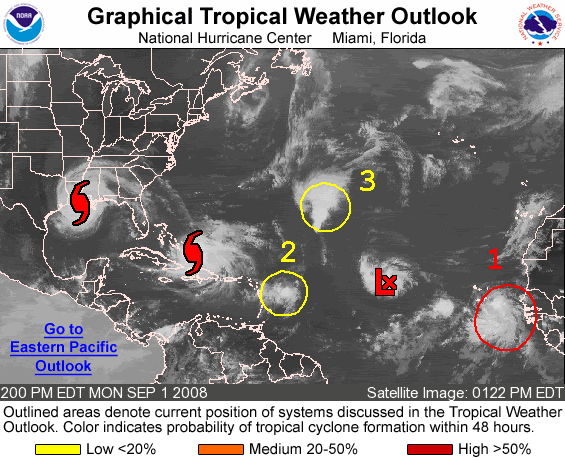

Ike is er nu ook al.
http://euler.atmos.colost(...)tic/track_early3.png
http://euler.atmos.colost(...)intensity_early3.png
http://euler.atmos.colost(...)tic/track_early3.png
http://euler.atmos.colost(...)intensity_early3.png
Dostojewski: "Je kunt je niet van je eigen gezond verstand overtuigen door je buurman op te sluiten."
Ike gaat recht op de GOM af
Ga er maar vanuit dat deze vanaf zaterdag gaat toenemen.
[ Bericht 48% gewijzigd door Drugshond op 02-09-2008 04:01:51 ]
Ga er maar vanuit dat deze vanaf zaterdag gaat toenemen.

[ Bericht 48% gewijzigd door Drugshond op 02-09-2008 04:01:51 ]


quote:PROVIDENCIALES, Turks and Caicos — Hurricane Hanna was moving little early Tuesday as its rains continued to affect the Bahamas along with the Turks and Caicos Islands.
The hurricane also threatened to hit the southeast United States later in the week.
Meanwhile, Tropical Storm Ike was headed toward the Caribbean and another tropical depression emerged as a new threat in the Atlantic, according to the National Hurricane Center in Miami.
Hanna, with maximum sustained winds near 80 mph, lingered for much of Monday near Mayaguana and nearby islands in the southeast Bahamas.
There were no immediate reports of injuries or major damage, but emergency teams were standing by and would begin assessing the situation once the storm has cleared, said Stephen Russell, interim director of the Bahamas National Emergency Management Agency.
"I'm quite certain there is going to be damage, particularly in Mayaguana," he said.
Hanna also was bringing strong winds, heavy rain and pounding surf to nearby islands, including Inagua and Crooked Island, and Turks and Caicos Islands to the south
"Right now, the uncertainty is such that it could hit anywhere from Miami to the outer banks of North Carolina," said Jessica Schauer Clark, a meteorologist at the U.S. National Hurricane Center. "So people really need to keep an eye on it."
Ike was approaching behind Hanna with maximum sustained winds near 50 mph (85 kph). Ike was centered about 1,235 miles (1,985 kilometers) east of the Leeward Islands and moving west near 15 mph (24 kph) early Tuesday. The tropical storm was expected to gain strength over the next two days.
And behind Ike, a new tropical depression formed early Tuesday with maximum sustained winds near 35 mph. The depression was forecast to strengthen and the hurricane center said it would likely become a tropical storm later in the day. The depression was centered about 170 miles south-southeast of the southernmost Cape Verde Islands off the coast of Africa.
NASA was not taking any chances — it announced a delay of at least a day in the planned move of the space shuttle Atlantis from an assembly building at Florida's Kennedy Space Center to the launch pad. The move had been scheduled for Tuesday in preparation for an October mission to the Hubble Space Telescope.
Florida state officials also were keeping nervous watch on Hanna and the weather behind it, careful not to overextend the assistance it provides to other Gulf Coast states dealing with Gustav.
"The storm's on top of us right now and it's blowing really hard," said Miguel Campbell, a mechanic with the Bahamas Electricity Corp. on Mayaguana, where some 300 people were hunkered down.
Hanna's winds and rain reached all the way to Haiti, where thousands remain homeless in the wake of Gustav, which was downgraded to a tropical depression as it moved over Louisiana early Tuesday.
In Puerto Rico, authorities said one man from Colombia was killed and a woman from Brazil was missing after they were swept away in a river swollen with rain from Hanna. The two were students at the University of Puerto Rico on a trip to the island's east.
The European Union said Monday it would give $2.9 million to help the recovery from Gustav, which killed 94 people. The money will pay for clean water, food, medical care, shelter and basic household items in Haiti, Cuba, Jamaica and the Dominican Republic. In Haiti, 8,000 people are in temporary housing after high winds and floods destroyed homes and farms.

Wij hebben de dans ontsprongen. Geen zuchtje wind gehad in Cancun, het enige dat we hebben meegekregen was hoog water, waardoor de stranden voor de helft waren weggevaagd (zand was weg, er lagen kale rotsen ipv een zandstrand).
Ziet er lekker uit, 3 tropische stormen op een rijtje en een depressie in de US.
Ziet er lekker uit, 3 tropische stormen op een rijtje en een depressie in de US.
traffic jam 
Dostojewski: "Je kunt je niet van je eigen gezond verstand overtuigen door je buurman op te sluiten."
Ike kan gevaarlijk worden.... Een run laat zien dat hij kan uitgroeien tot een CAT-4 boven Cuba
Ook zijn trajectorie is nog steeds richting GOM.
Ook zijn trajectorie is nog steeds richting GOM.
Lekker heb je net Gustav gehad... komt Ike er ook nog eens aan....quote:Op woensdag 3 september 2008 03:06 schreef Drugshond het volgende:
Ike kan gevaarlijk worden.... Een run laat zien dat hij kan uitgroeien tot een CAT-4 boven Cuba
Ook zijn trajectorie is nog steeds richting GOM.
en dan lopen we hier te klagen over 't weer
To deny our impulses would deny the very thing that make us human.
Het is maar één run...quote:Op woensdag 3 september 2008 03:06 schreef Drugshond het volgende:
Ike kan gevaarlijk worden.... Een run laat zien dat hij kan uitgroeien tot een CAT-4 boven Cuba
Ook zijn trajectorie is nog steeds richting GOM.
* I intend to live forever, so far so good! *
Misschien gaat Josephine de oostkust van de VS wel treffen....
In NYC wachten ze ook al tijden op zon scenario... waar de meeste mensen verwachten dat het koude zeewater dat niet mogelijk moet kunnen maken... maar het verleden spreekt tegen ze
In NYC wachten ze ook al tijden op zon scenario... waar de meeste mensen verwachten dat het koude zeewater dat niet mogelijk moet kunnen maken... maar het verleden spreekt tegen ze
HANNA...25 doden op Haiti
quote:De tropische storm Hanna heeft op Haiti aan 19 mensen het leven gekost. Het zwaarst gestroffen is Gonaives in het midden van het land. President Preval vraagt om internationale hulp.
Door de orkaan Gustav kwamen in het Caribisch gebied 90 mensen om, van wie op Haiti zeker 60,en in de VS acht. De schade in Louisiana wordt geschat op vier à tien miljard dollar.
Gustav heeft vorige week op Cuba een snelheidsrecord gevestigd: hij raasde met 340 kilometer per uur over het westen van het land. Het vorige record werd in 1953 gevestigd in Mexico met een windsnelheid van 286 km per uur.
nos
quote:Storms swirl in Atlantic, deadly floods hit Haiti
NASSAU, Sept 2 (Reuters) - Heavy rains flooded parts of Haiti with head-high water on Tuesday and sent walls of mud down the hillsides, killing at least 25 people as Tropical Storm Hanna swirled over the Bahamas and took aim at the southeastern United States.
A new tropical storm, Josephine, formed off Africa behind Tropical Storm Ike. Both were moving westward just as Hurricane Gustav dissipated after slamming into the U.S. Gulf Coast near New Orleans.
The flurry of Atlantic storms underscored predictions for a busier than normal hurricane season and was worrisome news for U.S. oil and natural gas producers in the Gulf of Mexico, millions of people living in the Caribbean and on U.S. coasts, and farmers fearing flooded fields.
The U.S. government has forecast 14 to 18 tropical storms will form during the six-month season that began on June 1, more than the historical average of 10. Josephine was already the 10th, forming before the statistical peak of the season on Sept. 10.
By Tuesday night, Hanna was bearing down on Great Inagua Island with 65 mph (100 kph) winds, the U.S. National Hurricane Center said.
It was expected to strengthen back into a Category 1 hurricane on the five-step Saffir-Simpson scale of intensity, with winds of at least 74 mph (119 kph) on Wednesday or Thursday.
Hanna dumped torrential rains on the southeastern Bahamas, the Turks and Caicos islands, Haiti and the Dominican Republic.
In Haiti, heavy rains caused severe flooding in the northern port city of Gonaives, where thousands of people died four years ago during a similar catastrophe.
"The city is flooded and there are parts where the water gets to 2 meters (6.5 feet)," said civil protection director Alta Jean-Baptiste. "A lot of people have been climbing onto the tops of their houses since last night to escape the flooding."
Authorities said flooding and mudslides from the storm killed at least 25 people across Haiti, including 12 in low-lying Gonaives and three in the nearby town of Gros Morne.
FLORIDA EMERGENCY
Hanna was nearly stationary but was forecast to turn northwest on a track that would take it near the Bahamian capital of Nassau and near the U.S. East Coast on Thursday. It was likely to come ashore at the end of the week somewhere between northern Florida and the Carolinas.
Although the official forecast kept it over water as it skirted the Florida coast, state Gov. Charlie Crist declared a state of emergency.
Tropical Storm Ike headed west after forming on Monday between Africa and the Caribbean and appeared likely to become a hurricane that would threaten the Caribbean islands and possibly the United States.
It was too early to say where Ike might go but the storm drew the attention of energy companies running the 4,000 offshore platforms in the Gulf of Mexico that provide the United States with a quarter of its crude oil and 15 percent of its natural gas.
Ike was about 930 miles (1,500 km) east-northeast of the Leeward Islands and moving west at 17 mph (28 kph) late on Tuesday. Its top sustained winds had strengthened to 65 mph (100 kph) and were expected to reach hurricane strength of 74 mph (119 kph) on Wednesday.
Josephine swirled over the far eastern Atlantic about 180 miles (290 km) west-southwest of the Cape Verde Islands. It was moving west at 12 mph (19 kph), with top sustained winds of near 50 mph (85 kph), and could become a hurricane on Wednesday. (Additional reporting by Joseph Guyler Delva in Port-au-Prince; Writing by Tom Brown and Jane Sutton; Editing by Eric Walsh)
Hanna kan nog wel eens de oceaan over steken, England over en daarna een leuk stormpje in NL achter latenquote:Op woensdag 3 september 2008 10:27 schreef Frutsel het volgende:
Rare koers die Hanna ineens maakt of nie?
Tja, we zitten idd midden in het seizoen

Of Hanna als categorie 1quote:Op woensdag 3 september 2008 08:34 schreef Frutsel het volgende:
Misschien gaat Josephine de oostkust van de VS wel treffen....
In NYC wachten ze ook al tijden op zon scenario... waar de meeste mensen verwachten dat het koude zeewater dat niet mogelijk moet kunnen maken... maar het verleden spreekt tegen ze
Meet me in Montauk.... Nou ja, met dat stuk dat Hanna over land gaat in Carolina, zal er niet heel veel meer in zitten tegen de tijd dat ze in New England aankomt. En Josephine zit voorlopig wel op Clementine scenario lijken te zitten, maar die komt nog een stevige stroom de andere kant op tegen voor ze bij de VS zit. Die gaat dus Bertha 2 worden, denk ik.
Laat die nazomer hier maar komen
Laat die nazomer hier maar komen
Daar zat ik ook al aan te denken. Mag van mij.quote:Op woensdag 3 september 2008 20:17 schreef thijsdetweede het volgende:
Die gaat dus Bertha 2 worden, denk ik.
Laat die nazomer hier maar komen