WKN Weer, Klimaat en Natuurrampen
Lees alles over het onstuimige weer op onze planeet, volg orkanen en tornado's, zie hoe vulkanen uitbarsten en hoe Moeder Aarde beeft bij een aardbeving. Alles over de verwoestende kracht van onze planeet en tal van andere natuurverschijnselen.


Madagascar
As Madagascar continued to recover from destruction brought by cyclone Fame in late December 2007, another cyclone - Ivan - hit the island on 17 February. With winds of up to 230 kilometres per hour, Ivan caused major damage and many casualties, especially in the country's east.
According to the latest figures released by the National Office of Disaster Preparedness, 44 people were killed by Ivan, with 478 people injured and 17 still unaccounted for. In all, 210,852 were directly affected, with 147,719 left homeless. Approximately 15,880 hectares of rice paddy was also destroyed along with more than 40,000 hectares of other crops.
Malagasy Red Cross volunteers were mobilized as soon alert about the cyclone was first raised on 15 February. Sensitization campaigns took place before the cyclone made landfall, with volunteers going house-to-house to tell local communities how to act before, during and after the storm.
After Ivan hit, the same volunteers were also involved in emergency operations and in evaluating the storm's damage. Other more specialised teams also went into action to conduct more detailed evaluations. A total of 140 volunteers were mobilized by Malagasy Red Cross in seven districts in the eastern part of the country.
Besides evaluating damages, the Malagasy Red Cross also received extra help from the French Red Cross which mobilized its regional intervention platform in the Indian Ocean (PIROI) to provide major logistical support. Twelve tonnes of material was sent from the main centre on La Reunion Island, including tarpaulins, tool kits, generators, water tablets and other emergency items.
Some of these supplies were sent to Sainte Marie to help local communities and authorities begin to recover. The city of Sainte Marie, on the country's east coast, was one of the regions most severely hit by cyclone Ivan with 14 people injured, 16, 530 affected people, 9,626 losing their homes. There are also a total of 186 flooded houses and 3,464 roofless houses. Other supplies will be distributed in other areas following the outcome of ongoing assessments.
Also in the eastern part of the country, the Malagasy president made a donation of 8 millions of ariary (about 4,700 Swiss francs) to Malagasy Red Cross local branches along with 20 tonnes of rice. Thanks to this, the Red Cross has been able to distribute emergency items to 1,207 families, with each family receiving 16 kilograms of rice, 500 grams of salt, 1.5 litres of oil, two bars of soap, a candles and a lighter.
In other areas, including in the western part of the island, the Red Cross helped with medical screening of affected people as well as housing and helping to distribute food being provided by other agencies.
The International Federation of Red Cross and Red Crescent Societies will shortly release funds from its Disaster Relief Emergency Fund to support Malagasy Red Cross in its emergency operation.
bron

Orkanen brengen landbouw zware slag toe in Madagascar
Op het tropische eiland Madagascar is het aantal slachtoffers als gevolg van de orkanen Fame en Ivan, die daar sinds het begin van het jaar lelijk hebben huisgehouden, na bijgestelde cijfers van de rampenbestrijdingsdienst gestegen tot meer dan 100 doden en 580 gewonden. Minstens 177 mensen, de meesten van hen in het gebied aan de zwaar getroffen oostkust en de havenstad Tamatave, worden nog vermist. Wegens de slechte informatiedoorstroming uit de afgesneden gebieden kunnen die aantallen nog verder oplopen.
De voedselvoorziening van de 500.000 daklozen over heel het land is zorgwekkend. Tweehonderdduizend hectare landbouwgronden zijn overstroomd en de oogsten vernield. In totaal hebben de wervelstormen met windsnelheden van boven de 200 kilometer per uur meer dan 133.000 woningen, hutten en vele hotelaccommodaties vernield. Rond de 2.000 scholen, overheidsgebouwen of bruggen liepen schade op.
Het Wereldvoedselprogramma, Care International, UNICEF, lokale hulporganisaties en vele donorlanden hebben onder andere geld, levensmiddelen, tenten en geneesmiddelen ter beschikking gesteld.(KS)
bron:
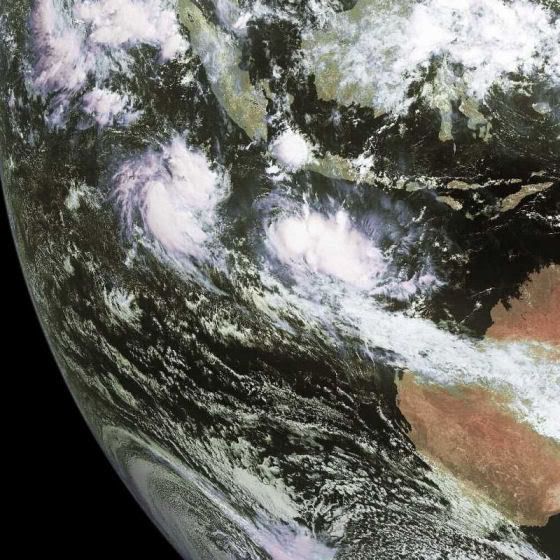
Deze cycloon brengt regenhoeveelheden met zich mee van zo'n 16 centimeter en golven van meer dan 6 meter hoog.quote:Tropical cyclone Jokwe is forecast to strike Mozambique at about 00:00 GMT on 8 March. Data supplied by the US Navy and Air Force Joint Typhoon Warning Center suggest that the point of landfall will be near 16.4 S, 40.8 E. Jokwe is expected to bring 1-minute maximum sustained winds to the region of around 175 km/h (109 mph). Wind gusts in the area may be considerably higher.

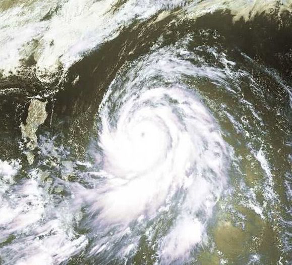
Tropical Cyclone Jokwe
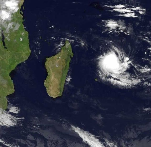
The compact Tropical Cyclone Jokwe had just skimmed past northern Madagascar and was moving south into the Mozambique Channel when the Moderate Resolution Imaging Spectroradiometer (MODIS) on NASA’s Aqua satellite captured this photo-like image on March 7, 2008. Loose bands of clouds circle a tightly packed core and a small, but defined eye that resembles a pin prick in a field of white. Though small, the cyclone was expected to bring winds and heavy rain to coastal Mozambique as it tracked south along the shore. At the time MODIS acquired this image on the afternoon of March 7, Jokwe had winds estimated at 160 kilometers per hour (100 miles per hour or 85 knots) with gusts to 190 km/hr (120 mph or 105 knots), said the Joint Typhoon Warning Center.
Jokwe follows in the wake of powerful Cyclone Ivan, which devastated Madagascar between February 17 and February 19, 2008. As of February 29, the death toll from Cyclone Ivan had surpassed 80, reported Reuters. Fortunately, Jokwe’s path did not take the storm over parts of Madagascar affected by Ivan.

Cyclone Jokwe flays Mozambique, one killed
Source: Reuters
MAPUTO, March 9 (Reuters) - Tropical cyclone Jokwe lashed nothern Mozambique on Sunday, killing at least one person and destroying over 500 homes, a meteorological official said.
Mussa Mustafa, head of Mozambique's National Meteorological Institute, said the cyclone which swept through part of Madagascar last week, is expected to intensify by Monday.
"Our (meteorological) colleagues in the coastal district of Angoche reported that one person died when his house collapsed, and we also have a number of houses which have been extensively damaged there", Mustafa told Reuters.
Radio Mozambique reported that scores of people have fled their homes in the northern Nampula Province and national television broadcast footage of electricity pylons brought down by strong winds of up to 200 kph (125 miles).
Mustafa said the risk of renewed flooding was small because the rains would hit coastal areas and flow into the ocean.
Tens of thousands of people in Mozambique were forced to flee their homes earlier this year in what the United Nations said could be the worst floods in memory, engulfing farmland and wrecking roads and bridges. Last month Cyclone Ivan smashed Madagascar, killing more than 80 people and leaving over 200,000 homeless, but lost steam before striking Mozambique. (Reporting by Charles Mangwiro, writing by Marius Bosch)
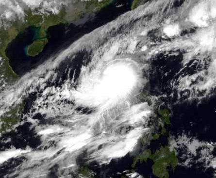
Tropical Cyclone Jokwe
Tropical Cyclone Jokwe grazed along the southern coast of Madagascar on the morning of March 11, 2008, when it was observed by the Moderate Resolution Imaging Spectroradiometer (MODIS) on NASA’s Terra satellite. Days before, the tropical cyclone careened back and forth on a curved arc down the Mozambique Channel between mainland Africa and Madagascar, bringing strong winds and rain to both Madagascar and coastal Mozambique.
MODIS acquired this image on March 11 at 10:35 a.m. local time (7:35 UTC). In this photo-like view, Cyclone Jokwe is a small but tightly wound spiral off the south-western coast of Madagascar, with a distinct but cloud-filled (“closed”) eye. According to the Joint Typhoon Warning Center, Jokwe had sustained winds of around 150 kilometers per hour (90 miles per hour), very roughly the same as it had been for the previous five days. However, as of March 11, forecasters were expecting the storm to weaken as it cleared the southern end of Madagascar and traveled over cooler waters.

Cyclone heads to Mozambique tourist area and Madagascar
Source: Reuters
MAPUTO, March 13 (Reuters) - The tropical cyclone that has lashed parts of Mozambique, killing 10 people, is expected to hit the southern tourist region of the country before gathering speed on its way to Madagascar, authorities said on Thursday.
Cyclone Jokwe struck ferociously last Friday, displacing 55,000 people, destroying electricity pylons and uprooting trees in the northern Nampula province.
"It is too dangerous for shipping. It is now over the Mozambique channel on its current course and is likely to strike both Mozambique and Madagascar again," Mussa Mustafa, head of the National Institute of Meteorology, said in an interview.
He said the cyclone was headed for the southern provinces of the country and would make landfall in Madagascar on Monday.
Tourism operators in the southern Mozambique's district of Vilankulo are bracing themselves for the high-speed cyclone.
Ray Monson, manager of Casa Rex lodge, told Reuters he was preparing for the storm to avoid being caught off guard.
"We are monitoring the cyclone and keeping our clients updated, it is still far from here but anything can happen, this time we are more prepared than before", he said by telephone.
In February last year, Cyclone Favio killed 10 people, destroyed infrastructure in the area and shut down businesses.
Earlier this week, the director of Mozambique's National Institute of Disaster Management said Jokwe with its 200 mph winds was more dangerous than Favio. Jokwe has already killed 10 people and has not yet crossed the entire region.
The mayor of Vilanculo, Sulemane Amugi, said the town was taking the necessary steps to avoid unnecessary destruction.
"We are alerting tourists operators particularly those on the beach side to stay clear of the sea on Friday. We have also instructed fishermen not to go into the waters, but we are hoping that it will loose strength before reaching the coast." (Editing by Phumza Macanda and Mary Gabriel)
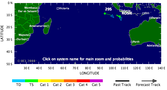
Tropical Storm 25S is Tropical Storm LOLA geworden.
Gaat nog steeds de kant van madagascar op.
Koers kan altijd nog anders worden uiteraard.
Gaat nog steeds de kant van madagascar op.
Koers kan altijd nog anders worden uiteraard.


Fasten your seatbelts, it's gonna be a bumpy hurricane season.!
That's the latest word from a team of Colorado State University forecasters, who predict the nation's Atlantic coast will experience a hurricane season "well above average."
"Current oceanic and atmospheric trends indicate that we will likely have an active Atlantic basin hurricane season," said William Gray, who heads the university's forecast team.
The forecasters predict at least 15 named storms will form in the Atlantic basin between June 1 and Nov. 30.
Eight of the storms are predicted to become hurricanes, and of those eight, four are expected to develop into intense or major hurricanes with sustained winds of 111 mph or greater.
"Based on our latest forecast, the probability of a major hurricane making landfall along the U.S. coastline is 69 percent compared with the last-century average of 52 percent," said Phil Klotzbach, a member of the forecast team. "We are calling for a very active hurricane season this year, but not as active as the 2004 and 2005 seasons."
The 2005 season — the year of Katrina, Rita, Wilma, Dennis and Emily — caused a record $128 billion in damage, with at least 2,280 reported deaths.
The 2004 season was one of the deadliest, with at least 3,100 deaths and more than $50 billion in damage.
The Colorado State team reported that current conditions in the Atlantic basin are very favorable for an active hurricane season. The current warm sea surface temperatures in the Atlantic are likely to continue in the tropical and North Atlantic during 2008.
Additionally, the team expects neutral or weak La Nina conditions in the tropical Pacific, which, combined with a predicted warm north and tropical Atlantic, is a recipe for enhanced Atlantic basin hurricane activity.
These factors are similar to conditions that occurred during the 1950, 1989, 1999, and 2000 seasons. The average of these four seasons had well above-average activity, and Klotzbach and Gray predict the 2008 season will have similar activity.
The hurricane forecast team's probabilities for a major hurricane making landfall in the U.S. are:
— A 69 percent chance that at least one major hurricane will make landfall on the U.S. coastline (the long-term average probability is 52 percent).
— A 45 percent chance that a major hurricane will make landfall on the East Coast, including the Florida Peninsula (the long-term average is 31 percent).
— A 44 percent chance that a major hurricane will make landfall on the Gulf Coast from the Florida Panhandle west to Brownsville, Texas (the long-term average is 30 percent).
The team also predicted above-average major hurricane landfall risk in the Caribbean.
"The United States was quite fortunate over the last two years in that we had only one hurricane landfall (Humberto, in 2007)," Klotzbach said. "None of the four major hurricanes that formed in 2006 and 2007 made U.S. landfall."
The Colorado State hurricane forecast team cautioned against reading too much into the hurricane seasons of 2004 and 2005.
"The activity of these two years was unusual, but within the natural bounds of hurricane variation," Gray said.
(Bron)
Een storm die waarschijnlijk richting Vietnam trekt.
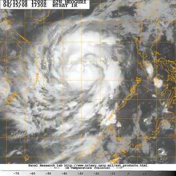
Tropical Storm 02W in de N.W. Pacific.
[ Bericht 8% gewijzigd door #ANONIEM op 15-04-2008 21:25:45 ]
Tropical Storm 02W in de N.W. Pacific.
quote:Tropical storm 02W is forecast to strike the Philippines at about 12:00 GMT on 14 April. Data supplied by the US Navy and Air Force Joint Typhoon Warning Center suggest that the point of landfall will be near 9.2 N, 119.0 E. 02W is expected to bring 1-minute maximum sustained winds to the region of around 64 km/h (40 mph). Wind gusts in the area may be considerably higher.
[ Bericht 8% gewijzigd door #ANONIEM op 15-04-2008 21:25:45 ]
Vietnam gaat geen last krijgen van NEOGURI.
China gaat nu de volle laag krijgen.
Momenteel koerst de cat1 recht op het eiland Hainan af.
China gaat nu de volle laag krijgen.
Momenteel koerst de cat1 recht op het eiland Hainan af.
niet echt gerelateerd aan het 2008 seizoen, maar voor orkaan-junkies wel interessant om te weten:
Professor Kerry Emanuel, de orkaanexpert die in 1985 als een van de eersten een verband legde tussen orkanen en global warming en in 2005 weken voor Katrina een onderzoek publiceerde waarin zijn hypothese "bewezen" werd, heeft nu een nieuw onderzoek gepubliceerd met hele andere conclusies.
De publicatie van Emanuel zelf hier
edit: quote uit de samenvatting toegevoegd
[ Bericht 5% gewijzigd door Ared op 17-04-2008 13:42:44 ]
Professor Kerry Emanuel, de orkaanexpert die in 1985 als een van de eersten een verband legde tussen orkanen en global warming en in 2005 weken voor Katrina een onderzoek publiceerde waarin zijn hypothese "bewezen" werd, heeft nu een nieuw onderzoek gepubliceerd met hele andere conclusies.
quote:A new technique for deriving hurricane climatologies from global data, applied to climate models, indicates that global warming should reduce the global frequency of hurricanes, though their intensity may increase in some locations.
Artikel met wat achtergrondinformatie en samenvatting voor leken in de Houston Chronicles hierquote:It is noteworthy that simulated global tropical cyclone power dissipation increases by more than 60% in simulations driven by NCAR–NCEP reanalysis over the period of 1980–2006, consistent with deductions from best-track data, while global power dissipation increases somewhat more than that over the next 200 yr in simulations driven by climate models undergoing global warming. This suggests either that the greater part of the large global increase in power dissipation over the past 27 yr cannot be ascribed to global warming, or that there is some systematic deficiency in our technique or in global models that leads to the underprediction of the response of tropical cyclones to global warming.
De publicatie van Emanuel zelf hier
edit: quote uit de samenvatting toegevoegd
[ Bericht 5% gewijzigd door Ared op 17-04-2008 13:42:44 ]
Whehe... ben zelf lid van dat blad. En Kerry Emanuels "Atmospheric Convection" ligt op mijn bureau.
Onderzoek naar klimaatvariabiliteit en het effect daarvan op orkanen (en andersom) staat nog ontzettend in de kinderschoenen. Zowel dit verhaal als Emanuels voorgaande verhaal moet dus niet als iets definitiefs worden gezien, maar eerder als een gedachtesprongetje in een discussie. Temeer daar de hoeveelheid data nou niet echt overhoudt; slechts tientallen orkanen per jaar over een halve eeuw met enorme fluctuaties erin, dat maakt het lastig om een trend te ontdekken.
Het pleit overigens voor Emanuel dat hij genuanceerd van mening durft te veranderen.
bron:quote:Waar blijven de orkanen?
Sinds de ramp in New Orleans als gevolg van orkaan Katrina woedt er in Amerika een hevig debat over de vraag of er meer of krachtigere orkanen zullen komen door de opwarming van de aarde. Dat debat is nog onbeslist.
Na de zeer actieve orkaanjaren 2004 en 2005 voorspelden onderzoekers van de Colorado State University (waaronder de beroemde orkaanvoorspeller William Gray) dat ook 2006 en 2007 zeer actieve jaren zouden worden. Die voorspelling kwam echter niet uit. Het was zelfs opvallend rustig.
Met zulke grote verschillen tussen de orkaanseizoenen is het lastig iets te weten te komen over langjarige veranderingen. Volgens de huidige stand van kennis kan het aantal orkanen in een warmer klimaat zowel toe- als afnemen.
Critici wijzen er intussen op dat het vooral de alarmerende artikelen zijn die de aandacht krijgen. Politicoloog Roger Pielke jr constateerde op zijn weblog Prometheus dat een vakpublicatie over orkanen in juli 2007 in twee dagen tijd 79 nieuwsartikelen opleverde, terwijl een artikel over hetzelfde onderwerp in topblad Nature een paar maanden later slechts drie berichten genereerde. Het eerste artikel constateerde dat de opwarming van de aarde meer en krachtiger orkanen zal opleveren; het tweede juist het tegenovergestelde.
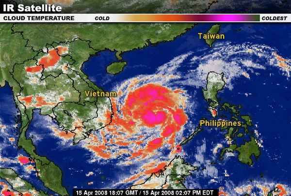
Typhoon NEOGURI is nu een categorie 2.
Typhoon Neoguri was nearing its peak strength on April 17, 2008, when the Moderate Resolution Imaging Spectroradiometer (MODIS) on NASA’s Aqua satellite captured this image at 1:30 p.m. local time (05:50 UTC). The first typhoon of the 2008 season in the western Pacific, Neoguri was a relatively weak Category 2 storm. Despite its small size, it was well formed with distinct bands of clouds circling a clear eye. A few hours after this image was taken, Neoguri had winds estimated at 160 kilometers per hour (98 miles per hour or 85 knots) with gusts to 195 km/hr (120 mph or 105 knots). The storm was forecast to weaken as it moved over the South China Sea to eastern Hainan and mainland China. The Joint Typhoon Warning Center predicted that the storm would come ashore over southern China on April 19.
bron:
[ Bericht 48% gewijzigd door #ANONIEM op 17-04-2008 21:20:49 ]
Typhoon Neoguriquote:Typhoon Neoguri is forecast to strike China at about 06:00 GMT on 18 April. Data supplied by the US Navy and Air Force Joint Typhoon Warning Center suggest that the point of landfall will be near 18.6 N, 111.3 E. Neoguri is expected to bring 1-minute maximum sustained winds to the region of around 148 km/h (92 mph). Wind gusts in the area may be considerably higher.

Typhoon Neoguri was nearing its peak strength on April 17, 2008, when the Moderate Resolution Imaging Spectroradiometer (MODIS) on NASA’s Aqua satellite captured this image at 1:30 p.m. local time (05:50 UTC). The first typhoon of the 2008 season in the western Pacific, Neoguri was a relatively weak Category 2 storm. Despite its small size, it was well formed with distinct bands of clouds circling a clear eye. A few hours after this image was taken, Neoguri had winds estimated at 160 kilometers per hour (98 miles per hour or 85 knots) with gusts to 195 km/hr (120 mph or 105 knots). The storm was forecast to weaken as it moved over the South China Sea to eastern Hainan and mainland China. The Joint Typhoon Warning Center predicted that the storm would come ashore over southern China on April 19.
bron:
[ Bericht 48% gewijzigd door #ANONIEM op 17-04-2008 21:20:49 ]
quote:
Niet volgens Wikipedia,quote:Na de zeer actieve orkaanjaren 2004 en 2005 voorspelden onderzoekers van de Colorado State University (waaronder de beroemde orkaanvoorspeller William Gray) dat ook 2006 en 2007 zeer actieve jaren zouden worden. Die voorspelling kwam echter niet uit. Het was zelfs opvallend rustig.
Opvallend rustig is inderdaad niet waar. (2007 dan)quote:
2006 hebben ze totaal verkeerd voorspeld. (dat was wel een rustig seizoen)
De voorspelling van 2007 zag er een stuk beter uit.
China typhoon weakens, 18 fishermen missing
BEIJING, April 19 (Reuters) - Typhoon Neoguri has weakened into a tropical storm after slamming into the southern Chinese island province of Hainan, with 18 fishermen reported missing, state media said on Saturday.
The storm forced the cancellation of 76 flights, caused a power black-out in Hainan's northeastern city of Wenchang, and is now moving into Guangdong province, Xinhua news agency said.
Guangdong flood control authorities said residents in low-lying areas and dangerous houses had all been evacuated to safety, it reported. About 20,000 boats in Guangdong had returned to port.
Though 38 fisherman who had sought shelter in reefs around the Paracel Islands in the South China Sea had been rescued, another 18 from the same group were still missing, Xinhua said.
"All the three boats were damaged and the 38 rescued fishermen swam to reefs and stayed there until being found by a rescue ship," Zhang Jie, vice director of the Hainan Maritime Safety Administration, was quoted as saying.
Chinese scientists have blamed global warming for increasing weather extremes, including devastating typhoons, snow storms, floods and drought, which they say are likely to get worse.
Typhoons, known in the West as hurricanes, are cyclonic storms which draw strength from the warm waters of the South China Sea and regularly target the Philippines, Japan, China, Taiwan and Hong Kong over the summer, sometimes with catastrophic effect.
The typhoon season usually starts in May. (Reporting by Ben Blanchard; Editing by Jeremy Laurence)
reuters
vorig jaar zat er een opmerkelijk groot verschil tussen rekenmethodes. Als je het aantal stormen bekijkt, was het een gemiddeld seizoen. Als je de ACE bekijkt, was het het rustigste seizoen sinds 1977.quote:Op vrijdag 18 april 2008 21:04 schreef aloa het volgende:
Opvallend rustig is inderdaad niet waar. (2007 dan)
2006 hebben ze totaal verkeerd voorspeld. (dat was wel een rustig seizoen)
De voorspelling van 2007 zag er een stuk beter uit.
bron
Een normaal aantal stormen, maar veel die zwak en geen lang leven hadden.quote:Op zaterdag 19 april 2008 12:56 schreef Ared het volgende:
[..]
vorig jaar zat er een opmerkelijk groot verschil tussen rekenmethodes. Als je het aantal stormen bekijkt, was het een gemiddeld seizoen. Als je de ACE bekijkt, was het het rustigste seizoen sinds 1977.
bron
quote:AccuWeather.com sees Atlantic hurricane above normal in '08
AccuWeather.com said Friday it expects warm La Ninca weather conditions to produce a slightly above average number of Atlantic hurricanes in 2008, and increasing the chance for U.S. landfall. "In some areas where hurricanes normally form - the central and eastern tropical Atlantic - ocean water temperatures are near or below normal," said meteorologist Joe Bastardi. "This should limit the number of storms, so we do not expect a near record high number like in the 2005 season. However, considering other factors, the number of storms should be slightly higher than historical averages."

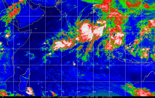
NARGIS gaat waarschijnlijk Birma of Bangladesch treffen.
Het ziet er niet goed uit voor die landen.
kaartje 72uur
Het ziet er niet goed uit voor die landen.
kaartje 72uur


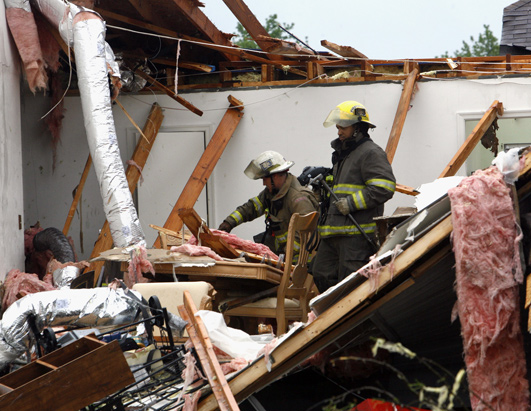
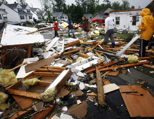
Storm raast over Virginia: minstens 200 gewonden
Bij een zware storm die over de Amerikaanse staat Virginia woedde, zijn gisteren zeker meer dan 200 mensen gewond geraakt. Gouverneur Timothy M. Kaine heeft in sommige delen van de staat de noodtoestand uitgeroepen.
De meeste slachtoffers vielen in Suffolk waar ongeveer 200 mensen gewond raakten. Het Sentara Obici Hospital werd ook getroffen door de storm, maar bleef operationeel. Volgens Dana Woodson, woordvoerster van de stad, zijn vele huizen vernietigd. "Vooral de buurt rond het hospitaal en het stadscentrum zijn zwaar getroffen.
In Colonial Heights, ten zuiden van Richmond, vielen 18 gewonden. Daar blies de storm auto's omver en werden verschillende huizen beschadigd.
http://hln.be/hln/nl/960/(...)s-200-gewonden.dhtml
=============
GOVERNOR KAINE DECLARES STATEWIDE EMERGENCY TO COORDINATE RESPONSE TO SEVERE WEATHER
RICHMOND, Va. — Governor Timothy M. Kaine today declared a state of emergency in the Commonwealth of Virginia, directing state agencies to take all necessary actions to aid in the response to widespread damage from this afternoon’s severe weather.
A declaration of emergency allows the Governor to immediately deploy state personnel, equipment and other emergency response resources, and to coordinate state and local response to the event.
Strong winds and possible tornadoes caused damage in multiple localities. The cities of Colonial Heights and Suffolk were two areas that were severely affected.
Agencies assisting include the Virginia departments of Emergency Management, Marine Resources and Transportation and the Virginia State Police. Other agencies are on standby if needed.
http://www.vaemergency.co(...)808gov_emergency.cfm
Bij een zware storm die over de Amerikaanse staat Virginia woedde, zijn gisteren zeker meer dan 200 mensen gewond geraakt. Gouverneur Timothy M. Kaine heeft in sommige delen van de staat de noodtoestand uitgeroepen.
De meeste slachtoffers vielen in Suffolk waar ongeveer 200 mensen gewond raakten. Het Sentara Obici Hospital werd ook getroffen door de storm, maar bleef operationeel. Volgens Dana Woodson, woordvoerster van de stad, zijn vele huizen vernietigd. "Vooral de buurt rond het hospitaal en het stadscentrum zijn zwaar getroffen.
In Colonial Heights, ten zuiden van Richmond, vielen 18 gewonden. Daar blies de storm auto's omver en werden verschillende huizen beschadigd.


http://hln.be/hln/nl/960/(...)s-200-gewonden.dhtml
=============
GOVERNOR KAINE DECLARES STATEWIDE EMERGENCY TO COORDINATE RESPONSE TO SEVERE WEATHER
RICHMOND, Va. — Governor Timothy M. Kaine today declared a state of emergency in the Commonwealth of Virginia, directing state agencies to take all necessary actions to aid in the response to widespread damage from this afternoon’s severe weather.
A declaration of emergency allows the Governor to immediately deploy state personnel, equipment and other emergency response resources, and to coordinate state and local response to the event.
Strong winds and possible tornadoes caused damage in multiple localities. The cities of Colonial Heights and Suffolk were two areas that were severely affected.
Agencies assisting include the Virginia departments of Emergency Management, Marine Resources and Transportation and the Virginia State Police. Other agencies are on standby if needed.
http://www.vaemergency.co(...)808gov_emergency.cfm
Op zaterdag 15 augustus 2009 23:05 schreef eer-ik het volgende:
Ik vind je sig nogal denigrerend.
Ik vind je sig nogal denigrerend.
quote:Tornado's houden weer huis in VS
WSHINGTON- Tornado's hebben vrijdag in de Amerikaanse staat Arkansas dood en verderf gezaaid. Reddingsdiensten vonden tot dusver drie lijken. Een van de slachtoffers is een meisje van vijftien jaar. Zij lag te slapen toen een ontwortelde boom op haar huis viel.
De meteorologische dienst meldde ook tornado's in Texas, Oklahoma en Kansas.
Bij vele tienduizenden mensen viel de stroom uit. Eerder deze week richtten tornado's al grote schade aan in Virginia. Honderden mensen raakten toen gewond door de 'twisters'.
Life is Music

quote:Teen Dead After Line of Tornadoes Hits Four States
Damage in Midwest as 19 Storms Hit; Storm System Moving East
Nineteen tornadoes swept through four Midwestern states overnight, leaving at least six people dead, according to The Associated Press, and a string of damage to homes and buildings.
weather
A 15-year-old girl in the northwest Arkansas town of Siloam Springs died when a tree fell through the bedroom where she was sleeping, according to The Associated Press.
Police say a 10-year-old boy was rescued from the same room and taken to an area hospital, where he was in good condition and expected to be released.
The line of storms extended through Kansas, Oklahoma, Missouri and Arkansas and is moving toward Illinois, where thunderstorm watches are in effect.
Storm chasers and residents caught video of storms in Kansas and other areas worthy of the "Wizard of Oz."
Related
Hurricane-force winds, hail and heavy rain moving through Missouri left hundreds of Kansas City-area homes and businesses damaged and some destroyed.
No serious injuries have been reported. About 40,000 customers were without power across the metro area, Kansas City Power & Light reported.
Authorities in Oklahoma were assessing damage today after two rounds of severe thunderstorms raked across parts of the state. The first round of storms produced at least two tornadoes Thursday night, causing some damage but no injuries.
The National Weather Service said a trained spotter saw a tornado touch down in central Arkansas as a series of storms began rolling through the state. More than 5,000 customers of Entergy Arkansas lost power. No injuries have been reported.
Op zaterdag 15 augustus 2009 23:05 schreef eer-ik het volgende:
Ik vind je sig nogal denigrerend.
Ik vind je sig nogal denigrerend.

Tornado's zijn wat anders als Hurricanes hoor, tornado's hebben een eigen topic 
Cyclone Nargis
On May 1, 2008, Typhoon Nargis hovered over the Bay of Bengal, having become a very severe cyclonic storm. A report issued by the U.S. Navy Joint Typhoon Warning Center at 15:00 UTC (approximately 9:00 p.m. local time) stated that the storm had intensified significantly over the previous six hours and was expected to come ashore in Myanmar (Burma) in the evening of May 2.
The Moderate Resolution Imaging Spectroradiometer (MODIS) on NASA’s Terra satellite acquired this image at 4:40 UTC (10:40 a.m. local time) on May 2, 2008. In this image, the sprawling storm spirals over the bay, between India in the west and Myanmar in the east. Bangladesh lies directly north of the storm. The storm appears to skirt the Andaman Islands in the southeast.
On May 1, Nargis had sustained winds of 90 knots, which would make it a Category 3 hurricane on the Saffir-Simpson hurricane scale, used to rank hurricanes in the United States. According to Voice of America News, even though the storm was predicted to make landfall in Myanmar, the cyclone’s proximity to Bangladesh caused serious concern in that nation as well, where memories lingered of the devastating Tropical Cyclone Sidr, which struck in 2007.
Just north of Nargis, along the coast of Bangladesh, are the Mouths of the Ganges—home to the Sundarbans, a massive mangrove forest. Mangrove forests can provide some protection to coastal regions during severe cyclones
Cyclone Nargis

On May 1, 2008, Typhoon Nargis hovered over the Bay of Bengal, having become a very severe cyclonic storm. A report issued by the U.S. Navy Joint Typhoon Warning Center at 15:00 UTC (approximately 9:00 p.m. local time) stated that the storm had intensified significantly over the previous six hours and was expected to come ashore in Myanmar (Burma) in the evening of May 2.
The Moderate Resolution Imaging Spectroradiometer (MODIS) on NASA’s Terra satellite acquired this image at 4:40 UTC (10:40 a.m. local time) on May 2, 2008. In this image, the sprawling storm spirals over the bay, between India in the west and Myanmar in the east. Bangladesh lies directly north of the storm. The storm appears to skirt the Andaman Islands in the southeast.
On May 1, Nargis had sustained winds of 90 knots, which would make it a Category 3 hurricane on the Saffir-Simpson hurricane scale, used to rank hurricanes in the United States. According to Voice of America News, even though the storm was predicted to make landfall in Myanmar, the cyclone’s proximity to Bangladesh caused serious concern in that nation as well, where memories lingered of the devastating Tropical Cyclone Sidr, which struck in 2007.
Just north of Nargis, along the coast of Bangladesh, are the Mouths of the Ganges—home to the Sundarbans, a massive mangrove forest. Mangrove forests can provide some protection to coastal regions during severe cyclones
Het is een behoorlijk grote catastrophe, die typhoon Nargis, volgens Nu.nl:
quote:Dodental Myanmar loopt op tot 10.000
Uitgegeven: 5 mei 2008 14:38
Laatst gewijzigd: 5 mei 2008 17:23
Het dodental in Myanmar als gevolg van de cycloon Nargis bedraagt volgens voorlopige cijfers van de regering van Myanmar 10.000. Nog eens 3000 mensen worden vermist. Dat zei een diplomaat maandag na een bijeenkomst met de Myanmarese minister van Buitenlandse Zaken Nyan Win.
"Het bevestigde getal is 3934 doden, 41 gewonden en 2879 vermisten in de districten Yangon en Ayeyarwaddy'', meldde de staatszender MRTV. Het officiële dodental is daarmee dramatisch gestegen. Tot nu toe waren 351 doden gemeld.
De cycloon richtte grote verwoestingen aan rond Yangon, de belangrijkste stad van het land. Vijf districten in het zuiden van het land zijn tot rampgebied uitgeroepen. Hier woont bijna de helft van de in totaal 53 miljoen inwoners van Myanmar, het vroegere Birma.
Het dodental zal waarschijnlijk stijgen als reddingswerkers de afgelegen gebieden weten te bereiken.
Verenigde Naties
De Verenigde Naties meldden eerder dat er honderdduizenden mensen dakloos zijn geworden en zonder schoon drinkwater zitten. In grote delen van het rampgebied is de elektriciteit uitgevallen en zitten mensen zonder schoon drinkwater.
Wervelstorm Nargis, met windstoten tot ruim 240 kilometer per uur, trok een spoor van vernielingen door het land. Wegen zijn geblokkeerd door puin en omgewaaide bomen. Bovendien wordt de bewegingsvrijheid van buitenlandse hulporganisaties door het militaire bewind beperkt.
Rellen gevangenis
In de beruchte Insein-gevangenis in Yangon, de belangrijkste stad van Myanmar, zijn zeker 36 gevangenen doodgeschoten tijdens rellen die uitbraken na de verwoestende cycloon Nargis. Dat meldde de doorgaans welingelichte Myanmarese mensenrechtenorganisatie AAPPB maandag vanuit de Thaise hoofdstad Bangkok.
Door de wervelstorm werden de daken van veel cellen afgerukt. Bewakers dreven circa duizend gevangenen daarna samen in een grote hal, waar vuurtjes werden gestookt om het warm te krijgen.
Toen vervolgens door zware rookwolken chaos en paniek uitbraken, openden militairen en agenten het vuur. Zeker zeventig gevangenen zouden gewond zijn geraakt.
Noodhulp
Verscheidene internationale hulporganisaties en de Verenigde Naties praten in Thailand over noodhulp. Thailand zelf heeft een transportvliegtuig met 9 ton voedsel en medicijnen naar het buurland gestuurd.
Europese Commissie
De Europese Commissie heeft maandag 2 miljoen euro voor noodhulp vrijgemaakt voor slachtoffers van de cycloon Nargis in Myanmar.
"Elk uur worden de berichten uit Myanmar grimmiger en grimmiger'', zei EU-commissaris Louis Michel. ,,Dit is een vreselijke ramp die snel en effectieve humanitaire hulp vereist.''
Rode Kruis
Het Nederlandse Rode Kruis opent gironummer 7447 voor de slachtoffers van de cycloon Myanmar in Birma. Dat heeft de organisatie maandag bekendgemaakt.
Huidige trend atmosf. CO2 Mauna Loa: 411 ppm ,10 jaar geleden: 387 ppm , 25 jaar geleden: 358 ppm
Even een eigen topic gegeven --> 10.000 doden in Myanmar na cycloon Nargis
Overigens heb ik net gehoord dat DE topics nu ook in NWS mogen voorkomen en andersom en naast elkaar blijven bestaan. Schroom dus niet om een DE topic dat in NWS staat, ook hier te openen.
Overigens heb ik net gehoord dat DE topics nu ook in NWS mogen voorkomen en andersom en naast elkaar blijven bestaan. Schroom dus niet om een DE topic dat in NWS staat, ook hier te openen.


Tropical Storm OPHELIA
Tropical storm Ophelia is forecast to strike the United States as a hurricane at about 12:00 GMT on 14 May. Data supplied by the US National Hurricane Center suggest that the point of landfall will be near 33.7 N, 77.8 W. Ophelia is expected to bring 1-minute maximum sustained winds to the region of around 120 km/h (74 mph). Wind gusts in the area may be considerably higher.
Tropical storm Ophelia is forecast to strike the United States as a hurricane at about 12:00 GMT on 14 May. Data supplied by the US National Hurricane Center suggest that the point of landfall will be near 33.7 N, 77.8 W. Ophelia is expected to bring 1-minute maximum sustained winds to the region of around 120 km/h (74 mph). Wind gusts in the area may be considerably higher.
Dean, Felix, Noel worden niet meer gebruikt als naam voor een toekomstige orkaan.
[ Bericht 3% gewijzigd door #ANONIEM op 14-05-2008 07:58:39 ]
quote:Dean, Felix, Noel retired from hurricane name list
(CNN) -- Three names -- Dean, Felix and Noel -- were permanently retired from the list of Atlantic hurricane names after storms bearing those monikers in 2007 caused damage in the Caribbean, Central America, Mexico and elsewhere, the National Oceanic and Atmospheric Administration said Tuesday.
Members of the organization voted to remove the names during its regional hurricane committee meeting, NOAA said in a written statement. "These names will not be used again because of the widespread destruction caused by these storms."
The list of tropical storm names recycles every six years. In 2013, the three names will be replaced with Dorian, Fernand and Nestor.
Although no storm in 2007 compared to historic hurricanes such as Andrew or Katrina, a storm doesn't have to be major to have its name retired. In 2001, for instance, Tropical Storm Allison, which never reached hurricane status, had its name retired after it dumped more than 3 feet of rain on Houston, Texas.
Since tropical storms were first named in 1953, 70 names have been retired, officials said.
[ Bericht 3% gewijzigd door #ANONIEM op 14-05-2008 07:58:39 ]
Categorie 1 Typhoon HALONG gaat voor overlast zorgen op de filipijnen.
[ Bericht 23% gewijzigd door #ANONIEM op 17-05-2008 11:05:02 ]
[ Bericht 23% gewijzigd door #ANONIEM op 17-05-2008 11:05:02 ]
quote:Tropische storm Halong bedreigd Filipijnen.
De tropische storm Halong trekt via de Zuid-Chinese zee richting Filipijnen.
Men verwacht dat deze morgenvroeg het noordelijke eiland Luzon zal treffen, wat ongetwijfeld zal leiden tot zware regenval en aan de westkust worden windsnelheden verwacht van meer dan 130km/u.
Weervoorspellers waarschuwen voor een sterke stormvloedkering rond de noordelijke kusten en verwachten op grote schaal overstromingen in de laaggelegen gebieden. Ook in de hoofdstad Manilla wordt zware regenval verwacht.
Volgens de laatste berichten heeft de tropische storm reeds de kusten bereikt en grote delen van het eiland zitten zonder stroomvoorzieningen.
De voorbije week werden er al duizenden mensen geëvacueerd na grootschalige overstromingen in het zuidelijk deel van de Filipijnen.
vwk
12 doden bij noodweer in Filipijnen
Twaalf mensen zijn omgekomen en negen gewond geraakt door zware storm en regen in de Filipijnen.
De tropische storm Halong kwam zaterdag met windsnelheden van 105 kilometer per uur aan land op het noordelijke eiland Luzon.
Vier mensen werden dodelijk getroffen door metalen platen die van huizen werden afgeblazen. Zo'n drieduizend huizen werden vernietigd, bomen werden ontworteld en elektriciteitsmasten werden omver geblazen, waardoor stroom en telefoon uitvielen
De boven land afgezwakte storm zal naar verwachting dinsdag ten zuiden van de Japanse hoofdstad Tokyo langstrekken. Daar wordt vooral veel regen verwacht.
bron:
Bericht uit de [url=http://www.nrc.nl/wetenschap/article1094465.ece/Cycloongevaar_neemt_af_door_opwarmingNRC[/url]
quote:Cycloongevaar neemt af door opwarming
Rotterdam, 20 mei. Het aantal tropische cyclonen boven Caribisch gebied zal onder invloed van het broeikaseffect eerder afnemen dan toenemen. Ook zullen waarschijnlijk minder cyclonen dan vroeger de Amerikaanse kust treffen.
Die verwachting wordt uitgesproken door onderzoekers van de Amerikaanse National Oceanic and Atmospheric Administration (NOAA) in het tijdschrift Nature Geoscience (18 mei). Dat het aantal cyclonen na 1980 is toegenomen en de komende eeuw vermoedelijk juist zal afnemen, komt volgens de onderzoekers doordat de Atlantische Oceaan eerder en sneller opwarmde dan de andere oceanen op aarde.
Dit staat haaks op de populaire opvatting dat de cycloonactiviteit door de huidige opwarming wordt versterkt (zoals ook Al Gore aanneemt). De NOAA-onderzoekers, onder leiding van Thomas Knutson, ontwierpen een regionaal computermodel dat redelijk in staat bleek het voorkomen van cyclonen en zware stormen tussen 1980 en 2006 te reconstrueren. Het aantal cyclonen nam in die periode trendmatig toe, maar vertoonde van jaar tot jaar grote verschillen: soms één cycloon en soms wel elf. Het model wist deze afwisseling na te bootsten.
Werd het nieuwe model ‘geladen’ met klimatologische gegevens zoals die voor de huidige eeuw worden voorzien, dan bleek het aantal cyclonen in het Caribische gebied beduidend af te nemen. Vooral onder de zwakkere cyclonen was dat opvallend. De zeldzame extreem zware cyclonen kunnen juist wat vaker voorkomen. Ook kan de hoeveelheid regen die in en rond cyclonen valt flink toenemen.
Hoe overtuigend het nieuwe model is, wordt niet duidelijk. Het bleek niet in staat de extreem zware cyclonen van de afgelopen 25 jaar te reconstrueren. Maar de uitkomst stemt verrassend overeen met die van een model van Kerry Emanuel, waarover in maart in het Bulletin of the American Meteorological Society is gepubliceerd. Dat voorspelde eveneens minder cyclonen, maar lokaal wel zwaardere. Kerry Emanuel van het MIT in Boston was de man die drie weken vóór orkaan Katrina in Nature (4 augustus 2005) op grond van simpele statistiek voorspelde dat cyclonen steeds zwaarder zouden worden. Die trend dacht hij te hebben waargenomen. Maar de meet-reeks is pijnlijk kort: cyclonen worden pas sinds 1970 door satellieten gesignaleerd. Of de onmiskenbare toename van de laatste 25 jaar een bijzonderheid is en of die samenhangt met het broeikaseffect staat niet vast.