WKN Weer, Klimaat en Natuurrampen
Lees alles over het onstuimige weer op onze planeet, volg orkanen en tornado's, zie hoe vulkanen uitbarsten en hoe Moeder Aarde beeft bij een aardbeving. Alles over de verwoestende kracht van onze planeet en tal van andere natuurverschijnselen.


Hier is dan het nieuwe topic voor Hurricane Season 2007 voor zowel Atlantische, Indische als Pacifische stormen.
Algemene Info
Met de term 'Hurricane Season' bedoelden we in eerste instante de periode van 1 juni tot 30 november.
Deze periode wordt in het Atlantische basin en de Golf van Mexico gezien als het “Stormen-seizoen Echter komen deze geweldadige stormen overal in de wereld voor en met name in Azie zorgen ze jaarlijks voor honderden slachtoffers en duizenden daklozen. Echter horen we erg weinig over de stormen in Azie en juist meer over die in de VS.
Naar aanleiding van documentairs over Hurricane Andrew 1992 en de newsberichten van de laatste jaren over o.a. Floyd, Stan en Ivan en natuurlijk de catastrofe "Katrina" beginnen we ook voor 2007 met een nieuw topic. Hoewel het Amerikaanse seizoen pas in Juni begint zijn er op andere plekken in de wereld zeker meer orkanen te vinden in de komende maanden. We zullen ook deze dus zeker gaan bespreken. Waarschijnlijk zal de kern van de discussie en de posts gaan over de periode 1-6-2006 t/m 30-11-2006. Daarvoor zal het wel niet storm gaan lopen
Waarschijnlijk zal er t.z.t. ook wel een NWS-topic worden geopend als een orkaan ook uitgebreid in het nieuws.
Hoe ontstaan ze?
op de site van Wikipedia kan je in het Nederlands nalezen hoe ze ontstaan en wat de belangrijkste energiebron is voor hun verwoestende kracht: het warme zeewater http://nl.wikipedia.org/wiki/Orkaan#Ontstaan
De BBC heeft er een interessante en leuke gif over gemaakt (met dank aan Roel)
http://news.bbc.co.uk/2/hi/science/nature/4588149.stm
Ook wordt er op LiveScience in het engels prima uitgelegd hoe ze ontstaan en zich ontwikkelen http://www.livescience.co(...)icane_formation.html
Indeling en Kracht
De stormen worden ingedeeld op categorie. Vaak zijn het eerst "tropische stormen" (Tropical Depression, Tropical Storms), die overgaan op Orkaanstatus (Hurricane) Ze worden ingedeeld op windsnelheden via de Saffire Simpson Schaal
Tropical Depression 24-38 mph winds (38-61 km/u)
Tropical Storm 39-73 mph winds (62-118 km/u)
Hurricane Categorie 1 74-95 mph winds (119-153 km/u) -- 4/5 ft Storm Surge -- Vb. Danny 1997, Stan 2005
Hurricane Categorie 2 96-110 mph winds (154-177 km/u) - 6/8 ft Storm Surge -- Vb. Danielle 2004
Hurricane Categorie 3 111-130 mph winds (178-209 km/u) -- 9/12 ft Storm Surge -- Vb.Fran 1996, Beta 2005
Hurricane Categorie 4 131-155 mph winds (210-249 km/u) -- 13/18 ft Storm Surge -- Vb.Hugo 1989, Frances 2004
Hurricane Categorie 5 > 156 mph winds (meer dan 250 km/u) -- 18ft or more S.S. -- Vb.Andrew 1992, Mitch 1998 en Wilma, Katrina 2005
Namen
De stormen, die vaak gevormd worden op de atlantische oceaan en dan richting de Caribbean of de Oostkust van de VS gaan, krijgen de naam op Alfabetische volgorde. Voor het seizoen 2005 zijn de namen als volgt:
Atlantische Stormen 2007
Andrea, Barry, Chantal, Dean, Erin, Felix, Gabrielle, Humberto, Ingrid, Jerry, Karen, Lorenzo, Melissa, Noel, Olga, Pablo, Rebekah, Sebastien, Tanya, Van, Wendy
In het oosten van de pacific ontstaan ook Hurricanes, ook wel Cylonen en/of Tyfoons genoemd. Deze zorgen vaak voor weinig schade aan de Amerikaanse westkust.
Oost Pacifische Stormen 2007
Alvin, Barbara, Cosme, Dalia, Erick, Flossie, Gil, Henriette, Ivo, Juliette, Kiko, Lorena, Manuel, Narda, Octave, Priscilla, Raymond, Sonia, Tico, Velma, Wallis, Xina, York, Zelda
Verder zijn er dan nog de stormen in het Noorden, Zuiden en Westen van de Pacific. Met name de stormen in het Noord/Westen komen vaak in het nieuws omdat ze Japan, Taiwan en China vaak teisteren, maar ook geheel Zuid Oost Azie kunnen treffen. De namen van deze stormen zijn terug te vinden op
[url]http://www.nhc.noaa.gov/aboutnames.shtml[url]
Wanneer zijn die seizoenen nou precies?
ATLANTIC: 1 mei t/m 30 november
NORTH EAST PACIFIC Begin mei t/m begin November, met piek in Augustus/September
NORTH WEST PACIFIC Begin juli t/m eind November, maar eigenlijk hele jaar door aktiviteit.
NORTH INDIAN April t/m December met pieken in Mei en November
SOUTH INDIAN + WEST AUSTRALIAN Oktober t/m Mei met pieken in Februari en April
SOUTH WEST PACIFIC + EAST AUSTRALIANOktober tot eind April met piek in Februari.
Over het algemeen is Mei de rustigste maand en September de ergste.
Hoe ziet de voorspelling voor 2007 eruit
Volgens Phil Klotzbach en William Gray van CSU wordt 2007 een actief jaar dat ze 'boven gemiddeld' noemen. Deze 'voorlopige' voorspelling deden ze op 8 december 2006. Ze voorspellen dan ook dat er 14 stormen komen die een naam krijgen, waarvan er 7 uitgroeien tot een orkaan. Van deze zeven zijn er 3 van Categorie 3 of hoger.
Verder voorspellen ze dat er 64% kans is dat er een zware orkaan in 2007 het gebied rondom Florida treft en dat er 40% kans is dat een orkaan de Oostkust van de VS aan doet. Vooral dit laatste vrezen de Amerikanen al jaren, want een 'lichte' Categorie 1 of 2 storm zou voor miljarden schade kunnen doen aan de dichtbevolkte oostkust van de VS.
(PS: Vorig jaar zaten beide heren er heel erg naast... )
Oude Delen
2004 - Deel 1 Hurricane Season 2004 en Deel 2 Hurricane Season 2004 -- Part 2
2005 - Deel 1 Tropical Cyclone Season 2005 en Deel 2 Hurricane/Cyclone Season 2005 - Part 2
2006 - Deel 1 [WFL] Hurricane Season 2006 en Deel 2 Hurricane Season 2006 #2
Enkele Links
1. Hurricane Season Special Edition Pagina van CNN van 2006
2. National Hurricane Centre
3. Carribean Storm Network
4. Florida University Hurricane Website
5. Action News from Florida + Webcams
6. Hurricane Track
7. Website met satelietbeelden van de Caribbean en de rest van Amerika
8. Intellicast: Geavanceerde satellietfoto's en gifs van aktuele stormen
9. Data over temperatuur / wind
10. Tropical Storm Risico's van dit moment
11. Actuele Watertemperatuur van dit moment
12. Wikipedia Hurricanes/Tyfonen in het algemeen
13. Overzicht aktuele typhoons in de pacific
14. Alle stormen ter wereld van de laatste jaren in overzicht
15. The StormTrack
Opmerkelijke Links
-- Hurricane Katrina CNN Special Report of the Killer Hurricane
-- Hurricane Katrina via WikiPedia
-- Hurricane Season 2005 -- Special van CNN
-- Hurricane Season 2004 -- Special van CNN
– Overzicht van Atlantische Stormen uit 2005
-- Spectaculaire Satelietshots van stormen
--Animatie van de alle Atlantische Stormen uit 2004
Openingspost
Klik hier
Actuele Radar in Golf van Mexico

Water temperatuur.
Last Update: 28-05-2007
=====================
Post hier je gegevens, nieuwsberichten, data en/of opmerkelijke zaken over de ‘Hurricanes en Cyclonen’ van 2007
[ Bericht 0% gewijzigd door Frutsel op 10-06-2007 18:04:44 ]
TS Glovis mag zich de eerste van 2007 noemen
[ Bericht 24% gewijzigd door Frutsel op 03-01-2007 11:16:39 (plaatje toegevoegd) ]

[ Bericht 24% gewijzigd door Frutsel op 03-01-2007 11:16:39 (plaatje toegevoegd) ]
Begint al goedquote:Op maandag 1 januari 2007 19:22 schreef Frutsel het volgende:
TS Glovis mag zich de eerste van 2007 noemen
[afbeelding]
<a href="https://www.youtube.com/channel/UCPueUwKfPaGH7v48LZlltkg" rel="nofollow" target="_blank">WSDokkum Youtube</a>

Stond nog een klein foutje in.quote:Op maandag 1 januari 2007 20:30 schreef Frutsel het volgende:
[..]
neem jij de OP weer voor je rekening? ff updaten?
quote:Post hier je gegevens, nieuwsberichten, data en/of opmerkelijke zaken over de ‘Hurricanes en Cyclonen’ van 2006 moet zijn 2007
hehehe... dat klopt idd.. ik was er gisteren al druk mee en drukte een verkeerde toets en alles was weg... frustratie ten top... daarna opnieuw moeten doen... en dat idd vergeten thxquote:Op maandag 1 januari 2007 20:33 schreef Drugshond het volgende:
[..]
Stond nog een klein foutje in.
[..]
<a href="https://www.youtube.com/channel/UCPueUwKfPaGH7v48LZlltkg" rel="nofollow" target="_blank">WSDokkum Youtube</a>
Misschien is het beter om de vraag hier te stellen: waarom komen orkanen in de regel alleen op het noordelijk halfrond voor?
"End this war against drugs. Legalise the drug against wars."
-
[b]Op donderdag 28 september 2006 09:12 schreef Rio het volgende:[/b]
Uiteindelijk is dit een star_gazer-krijgt-een-keiharde-lul-van-zichzelf-omdat-hij-zichzelf-verheven-voelt topic.
-
[b]Op donderdag 28 september 2006 09:12 schreef Rio het volgende:[/b]
Uiteindelijk is dit een star_gazer-krijgt-een-keiharde-lul-van-zichzelf-omdat-hij-zichzelf-verheven-voelt topic.

Goeie OP trouwens
"End this war against drugs. Legalise the drug against wars."
-
[b]Op donderdag 28 september 2006 09:12 schreef Rio het volgende:[/b]
Uiteindelijk is dit een star_gazer-krijgt-een-keiharde-lul-van-zichzelf-omdat-hij-zichzelf-verheven-voelt topic.
-
[b]Op donderdag 28 september 2006 09:12 schreef Rio het volgende:[/b]
Uiteindelijk is dit een star_gazer-krijgt-een-keiharde-lul-van-zichzelf-omdat-hij-zichzelf-verheven-voelt topic.
Dank je! Al is hij grotendeels uit WFL overgenomen van de lopende topics daar hoorquote:Op maandag 1 januari 2007 21:34 schreef star_gazer het volgende:
Goeie OP trouwens
Ze komen wel degelijk voor op het zuidelijk halfrond, rondom Australië en zoals nu Madagascar... alleen in veel mindere mate. Ik denk dat het te maken heeft met de zeestromingen al kan ik dat niet bevestigen. Dat moeten we op gaan zoekenquote:Op maandag 1 januari 2007 21:32 schreef star_gazer het volgende:
Misschien is het beter om de vraag hier te stellen: waarom komen orkanen in de regel alleen op het noordelijk halfrond voor?
Ik denk dat het afhankelijk is van vele condities (ff los uit de pols).
Water temperatuur
Convectie.
Koude en warme golfstromen.
Een warme zomer.
En een hoog en een laag drukgebied. (weet niet zeker).
Schijnbaar zijn de condities op het Noordelijk hafrond gewoon beter waardoor die dingen kunnen ontstaan.
Schijnbaar zijn de condities op het Noordelijk hafrond gewoon beter waardoor die dingen kunnen ontstaan.

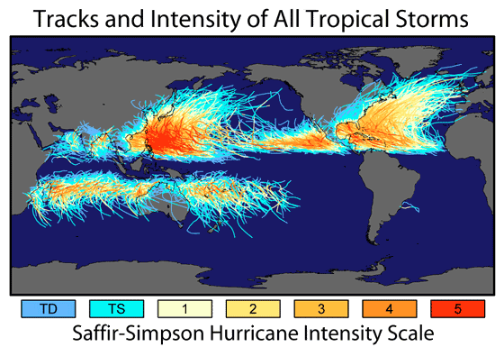
Hier een kaartje van orkanen van een aantal jaren lang.
Op de website http://www.globalwarmingart.com is een kaart verschenen met banen van alle tropische systemen. De systemen in de Atlantische Oceaan gaan terug tot 1860, de rest tot 1960.
Duidelijk is dat de zwaarste orkanen niet bij de Verenigde Staten voorkomen, maar bij Azië. Verder is te zien dat op het midden van de Stille Oceaan nauwelijks orkanen ontstaan.
De tropische systemen komen op de Atlantische Oceaan noordelijker en weten een enkele keer de Noordzee te bereiken of koudere gebieden. En voor de mensen die op details letten. Let ook even op de twee tropische systemen die de woestijn van Australië overleefden.
bron: VWK
Das een topplaatje! Vermelding in eventuele nieuwe OP-waardig!quote:Op maandag 1 januari 2007 22:23 schreef aloa het volgende:
Hier een kaartje van orkanen van een aantal jaren lang.
[afbeelding]
knip

Waarom hier nou niet
Ach ja, 2de alweer
Ach ja, 2de alweer
<a href="https://www.youtube.com/channel/UCPueUwKfPaGH7v48LZlltkg" rel="nofollow" target="_blank">WSDokkum Youtube</a>
Orkanen onstaan meestal uit samenklonteringen van onweersbuien die ontstaan in de Intertropische Convergentiezone (ITCZ): http://www.vwkweb.nl/cms/index.php?option=com_content&task=view&id=375quote:Op maandag 1 januari 2007 21:52 schreef Drugshond het volgende:
Ik denk dat het afhankelijk is van vele condities (ff los uit de pols).Water temperatuur Convectie. Koude en warme golfstromen. Een warme zomer. En een hoog en een laag drukgebied. (weet niet zeker).
Schijnbaar zijn de condities op het Noordelijk hafrond gewoon beter waardoor die dingen kunnen ontstaan.
Door rotatie van de aarde zal er op den duur een draaiende beweging in het geheel komen. Maar dat gebeurd pas bij 5 graden NB/ZB of hoger(/lager, het is maar hoe je het ziet ). Als zo'n complex te dicht bij de evenaar blijft zal er ook geen orkaan ontstaan.
Verder heeft het natuurlijk te maken met de temperatuur van het zeewater. Orkanen hebben zeewater van minimaal 28 graden nodig om zichzelf te voeden. Komen ze boven kouder water (of boven land) dan zwakken ze vrij snel af. Ik ben niet zo thuis in oceaanstromingen, maar ik vermoed dat er boven het zuidelijk halfrond veel minder warm water is. Verder is de ICTZ volgens mij ook kleiner op het zuidelijk halfrond.
Cause I'd rather continue my trip to the top of the mountain then freeze to death in the valley.
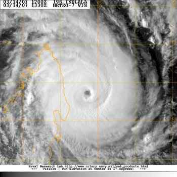
quote:Cycloon snel van de kaart
Bron : weathernews.nl
Geplaatst op: 4 Januari 2007
Op de eerste dag van dit jaar lag tropische cycloon Clovis boven de Indische Oceaan en stevende op Madagaskar af. Op 2 januari zwelde het systeem nog wat aan, maar gelukkig voor de eilandbewoners nam hij gisteren in kracht af.
Gisterenavond werd windkracht 9 gemeten, waardoor Clovis degradeerde tot een tropische storm. Vanochtend vroeg waaide het stormachtig, windkracht 8 en op Madagaskar deed Clovis zich gelden als een gewone depressie met heftige regen- en onweersbuien.
De inzetfoto laat Clovis zien toen hij gisteren overdag nog een echte cycloon was. Het andere plaatje toont het afgelegde traject. Op de bewegende satellietbeelden van Weathernews is goed te zien hoe snel het systeem in betekenis afneemt.

Regio Taiwan krijgt idd elk jaar veel meer en zwaardere orkanen te verduren als de VSquote:Op maandag 1 januari 2007 22:27 schreef Drugshond het volgende:
Ik weet wel dat Taiwan elk jaar een of meerdere keren in de prijzen valt.
We horen er hier alleen nauwelijks iets van meestal
silence can say more than thousand words
Een tekenend artikel, het klimaat in de VS is een klimaat waarin het klimaat moeilijk bespreekbaar is.
Hurricane center chief issues final warning click
A departing Max Mayfield is convinced that the Southeast is inviting disaster.
By Carol J. Williams, Times Staff Writer
January 3, 2007
Goeie OP, toppie
[ Bericht 2% gewijzigd door francorex op 06-01-2007 00:18:09 ]
Hurricane center chief issues final warning click
A departing Max Mayfield is convinced that the Southeast is inviting disaster.
By Carol J. Williams, Times Staff Writer
January 3, 2007
quote:Frustrated with people and politicians who refuse to listen or learn,
National Hurricane Center Director Max Mayfield ends his 34-year government career today in search of a new platform for getting out his unwelcome message:
Hurricane Katrina was nothing compared with the big one yet to come.

Hurricane season, orkaan seizoen 2007 welkom, en hallo stormwatchers.quote:But Mayfield warns that 10 times as many fatalities could occur in what he sees as an inevitable strike by a huge storm during the current highly active hurricane cycle, which is expected to last another 10 to 20 years.
Goeie OP, toppie
[ Bericht 2% gewijzigd door francorex op 06-01-2007 00:18:09 ]
Dan staat ze nog aardig wat te wachten als dat uitkomt.. zeker wanneer de kust dan nog niet verstevigd is, kan dat behoorlijke problemen opleveren..quote:Op vrijdag 5 januari 2007 23:30 schreef francorex het volgende:
Een tekenend artikel, het klimaat in de VS is een klimaat waarin het klimaat moeilijk bespreekbaar is.
Hurricane center chief issues final warning click
A departing Max Mayfield is convinced that the Southeast is inviting disaster.
By Carol J. Williams, Times Staff Writer
January 3, 2007
[..]
[afbeelding]
[..]
Hurricane season, orkaan seizoen 2007 welkom, en hallo stormwatchers.
Goeie OP, toppie
Hunting for Hurricanes in Africa
US atmospheric scientist Greg Jenkins takes his job hunting hurricanes off the coast of West Africa very personally.
"I had a lot of friends and relatives who really suffered when Hurricane Katrina hit New Orleans," he said.
"If we can get a better understanding of how these things form here in West Africa, we'll be able to extend our forecasting, and give people more time to get out of the way."
Mr Jenkins has swapped his job in Howard University in Washington State, for Dakar university in Senegal.
With his colleagues, he watches a short animated film again and again - satellite images of clouds over West Africa; the swirling, turbulent masses of moisture mixing and blending and separating in a mind-bogglingly complicated dance.
Outside, beneath the real black and grey clouds, wind turbines churned, harvesting data that is helping the scientists make sense of their mission.
This is to understand the weather systems that form over West Africa, head out across the Atlantic Ocean, and spin up into devastating hurricanes that ultimately batter the United States East Coast
Saharan air
The project is called the "Nasa African Monsoon Multidisciplinary Analyses" (Namma) and as the name implies, it draws in experts from a range of disciplines.
The team of technical and scientific brains came from Nasa, and an array of American universities, and French and Senegalese institutions.
Storm systems from the Sahara can turn into severe hurricanes
Between 80 and 100 storm systems form each year as bodies of hot, dry air over the Sahara Desert, pick up moisture as they move out across the Atlantic.
They get their initial power and instability from the difference in temperature between the very hot Sahara air and the substantially cooler air along the coast of the Gulf of Guinea.
Most peter out, shedding their energy along the way, but a few - about 10% - build power, becoming great, hulking behemoths that smash their way through the Caribbean Islands, and into the United States and Mexico.
Mr Jenkins and his team want to know what makes a hurricane.
To do it, they assembled an impressive array of technology: Nasa weather satellites provided sophisticated imagery from above; radars based in Senegal and the Cape Verde Islands further west gave a long-range view from the ground.
One of the radar analysts, atmospheric scientist Paul Kucera, said the West African weather systems are poorly understood.
"What we're learning is how storms evolve in this part of the region... their dynamics, their life-cycle, their internal characteristics that are unique to this region, that have never really been observed before by radar," he said.
Inside storm systems
But while the satellites and radar give important clues about what is going on inside the storms, neither are substitutes for a first-hand look.
To do that, the team called on two aircraft crammed with sophisticated sensors - a French Falcon and a DC-8 from Nasa - that flew through the heart of the storms to complete the picture.
Back at the Dakar university, the scientists debated which of the storms to send the Falcon through.
"It's really important that we find the weather systems that will build into hurricanes," said Mr Jenkins.
"The aircraft collects all sorts of data that we couldn't get any other way. It gives us a much better understanding of what's going on inside the storm systems; and helps us calibrate the satellites and understand what they are telling us from above."
The field work ended last September, but the researchers are continuing to analyse the mountain of data they managed to harvest.
Mr Jenkins believes it could be years before they come up with any definitive results, but they will ultimately improve the accuracy of existing forecasting models.
Inderdaad!quote:Op dinsdag 23 januari 2007 16:03 schreef aloa het volgende:
Daar is er al 1
Omgedoopt tot Cyclone Zita

Komt voorlopig ook nietquote:Op woensdag 24 januari 2007 11:28 schreef Drugshond het volgende:
qua Hurricans hebben we nog niet veel gezien in de golf van Mexico.
en vorig jaar was het een extreem rustig jaar voor hun
Stilte voor de storm ?
En de volgende krijgt de naam Arthur
Deze zit in hetzelfde gebied als Zita
[ Bericht 3% gewijzigd door #ANONIEM op 24-01-2007 21:50:19 ]
Deze zit in hetzelfde gebied als Zita
[ Bericht 3% gewijzigd door #ANONIEM op 24-01-2007 21:50:19 ]
Denk eerder stilte na de storm, aangezien 2005 een ongekend zwaar jaar was qua orkanen.quote:Op woensdag 24 januari 2007 11:29 schreef Frutsel het volgende:
[..]
Komt voorlopig ook niet
en vorig jaar was het een extreem rustig jaar voor hun
Stilte voor de storm ?
Dit jaar zou het qua hevigheid nog wel mee vallen denk ik volgend jaar weer een big bang
<a href="https://www.youtube.com/channel/UCPueUwKfPaGH7v48LZlltkg" rel="nofollow" target="_blank">WSDokkum Youtube</a>

Hoezo denk je dat? De natuur houdt zich niet aan een bepaald schema of zo hoor.quote:Op maandag 29 januari 2007 18:18 schreef SpeedyGJ het volgende:
Dit jaar zou het qua hevigheid nog wel mee vallen denk ik volgend jaar weer een big bang
Zeg ook maar wat hoorquote:Op dinsdag 30 januari 2007 16:47 schreef Eveli het volgende:
[..]
Hoezo denk je dat? De natuur houdt zich niet aan een bepaald schema of zo hoor.
<a href="https://www.youtube.com/channel/UCPueUwKfPaGH7v48LZlltkg" rel="nofollow" target="_blank">WSDokkum Youtube</a>

Maar is consistent met de gedachte dat El Nino afgelopen orkaan seizoen afgezwakt zou hebben; dat ding is nog niet over. Hoewel september nog een eind weg is.quote:
Ze hadden het er al dagen over, maar uiteindelijk toch nog ge-upgrade naar een TS. Nelson brengt al dagen zwaar weer in Noord Australië

Hurricane reasearch flights grounded click
thursday 7 2007
thursday 7 2007
quote:For the first time since NOAA began flying research aircraft into hurricane in the 1950's, there is no money to fund airborne hurricane research for an upcoming hurricane season. NOAA's state-of-the-art flying weather research laboratories, the two P-3 Orion hurricane hunter aircraft, may sit idle this hurricane season due to a lack of funding.

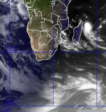
Favio op weg naar de Oostkust van de VS
Tropical Cyclone Favio formed in the western Indian Ocean about 1,200 kilometers from Madagascar on February 14, 2007. It gradually moved southwest, passing well offshore of Reunion and Mauritius Islands. By February 20, it was just off the southern shore of Madagascar as a well-formed, mature storm. While the storm system had largely skirted around populated areas to that point, forecasters were concerned about its behavior as it entered the warmer waters of the Mozambique Channel. The storm was forecast to reach Category Four strength before coming ashore and tracking inland through Zimbabwe and Zambia, bringing heavy rains to already flooded areas.

Tropical Cyclone Favio formed in the western Indian Ocean about 1,200 kilometers from Madagascar on February 14, 2007. It gradually moved southwest, passing well offshore of Reunion and Mauritius Islands. By February 20, it was just off the southern shore of Madagascar as a well-formed, mature storm. While the storm system had largely skirted around populated areas to that point, forecasters were concerned about its behavior as it entered the warmer waters of the Mozambique Channel. The storm was forecast to reach Category Four strength before coming ashore and tracking inland through Zimbabwe and Zambia, bringing heavy rains to already flooded areas.

Oostkust VS? Lijkt me eerder de oostkust van Afrika...quote:Op dinsdag 20 februari 2007 20:17 schreef Frutsel het volgende:
Favio op weg naar de Oostkust van de VS
[afbeelding]
Tropical Cyclone Favio formed in the western Indian Ocean about 1,200 kilometers from Madagascar on February 14, 2007. It gradually moved southwest, passing well offshore of Reunion and Mauritius Islands. By February 20, it was just off the southern shore of Madagascar as a well-formed, mature storm. While the storm system had largely skirted around populated areas to that point, forecasters were concerned about its behavior as it entered the warmer waters of the Mozambique Channel. The storm was forecast to reach Category Four strength before coming ashore and tracking inland through Zimbabwe and Zambia, bringing heavy rains to already flooded areas.
Ja, ik wou al zeggen, Madagaskar ligt toch nog ten westen van Afrika? Beetje vroeg nog om dan al te zeggen dat 'ie naar Oost-VS gaat.
Achter Favio komt inmiddels de volgende richting Madagascar.
Tropical Cyclone Gamede
en daar weer achter zit er nog eentje
Tropical Storm 16s
Tropical Cyclone Gamede

en daar weer achter zit er nog eentje
Tropical Storm 16s


Tjeem 3 orkanen daar. Gamede gaat madagascar keihard treffen. Ik vrees dat de natuur het daar zeer zwaar te verduren krijgt.
Drugs are good mkay?
Inderdaad... gaat misschien als cat.4 aan land daarquote:Op vrijdag 23 februari 2007 00:34 schreef Party_P het volgende:
Gamede gaat madagascar keihard treffen. Ik vrees dat de natuur het daar zeer zwaar te verduren krijgt.
Hier nog een plaatje van Gamede

Tropical Cyclone Gamede
Tropical Cyclone Gamede was spinning in middle of the Indian Ocean on February 21, 2007, when it was observed by NASA’s s QuikSCAT satellite at 5:03 p.m. local time (13:03 UTC). The nearest land to the storm system was Diego Garcia, several hundred miles north of the storm. The Joint Typhoon Warning Center forecast at the time did not call for the cyclone to be travelling anywhere near other significant land, so the storm poses no threat to population centers.
This data visualization of QuikSCAT’s observation shows Cyclone Gamede and its spiral pattern of winds. The image depicts wind speed in color and wind direction with small barbs. White barbs point to areas of heavy rain. Gamede appears as a well-formed spiral of winds centered around a strong eye with less wind at its center. This pattern is typical of tropical cyclones. Since the storm is in the Southern Hemisphere, the Coriolos effect which gives it its spinning shape turns clockwise, the opposite direction to hurricanes and typhoons which form in the Northern Hemisphere. According to the University of Hawaii’s Tropical Storm Information Center, Cyclone Gamede had sustained winds around 45 knots (83 kilometers per hour; 52 miles per hour) at the time of the QuikSCAT observation.
En de overstromingen van Madagascar na de vorige orkanen zijn nog niet eens opgelost terwijl Gamede eraan komt

A string of tropical cyclones, including Cyclones Favio, Clovis, and Bondo, struck Madagascar from December to February 2007, dumping heavy rain on the island nation. The resulting floods left almost 25,000 people in need of assistance and destroyed an estimated 200,000 tons of rice, reported Reuters on February 19. The Moderate Resolution Imaging Spectroradiometer (MODIS) on NASA’s Terra satellite captured the top image of flooding in western Madagascar on February 21, 2007. Full of the region’s characteristic red mud, the Betsiboka River and surrounding rivers are bright blue instead of black or dark blue, as water usually is in this type of image. The lower image, acquired on December 16, 2006, shows the rivers before the cyclones struck. These rivers are prone to flooding during the rainy season, and the cyclones and seasonal rains pushed them well over their dry-season extent. By February 21, the Betsiboka was a wide blue ribbon surrounded by pools of water.

Gamede en Humba. Stond op weerwoord .quote:Op vrijdag 23 februari 2007 20:11 schreef Frutsel het volgende:
Topfoto i2Them2!
Welke twee zijn dat? Favio en Ganime of Ganime en die 3e?


die onderste link staat volgens mij ook ergens tussen die in de OP...
maar mooie foto van weerwoord.be
maar mooie foto van weerwoord.be


Tropical Cyclone Gamede was in the western Indian Ocean off the shore of Madagascar on February 26, 2007. This powerful storm had been moving southward parallel to the eastern coast of Madagascar for two days at this time, bringing heavy rains and strong surf to Madagascar and the two major Mascarene Islands of Reunion and Mauritius. The storm seemed to be staying away from settled areas, but reports from the Joint Typhoon Warning Center and U.K. Accuweather noted strong surf on the coast and island shorelines, as well as heavy rain. This same area was brushed by Cyclone Favio just days before, as well as suffering a series of severe storms and cyclones in recent months. Unlike Favio, Gamede was predicted to continue on its generally southward track and not turn towards mainland Africa.
Inderdaad.. merkwaardige koerswijziging zegquote:Op woensdag 28 februari 2007 11:21 schreef Party_P het volgende:
Madagascar heeft nog enigzins geluk. Gamede gaat erlangs en niet erover heen.
Mazzel voor Madagascar
En we hebben George ten noorden van Australië
[ Bericht 24% gewijzigd door Frutsel op 04-03-2007 16:02:31 ]

[ Bericht 24% gewijzigd door Frutsel op 04-03-2007 16:02:31 ]
Bron: http://www.vwkweb.nl/cms/index.php?option=com_content&task=view&id=1181&Itemid=26quote:Orkaan ontstaat boven land
Ten zuiden van Darwin is de afgelopen dagen de tropische storm George ontstaan. George groeit de komende uren uit tot een orkaan. Het komt niet vaak voor dat een orkaan boven land ontstaat.
George is ontstaan uit een tropische depressie en heeft in de buitenwijken van Darwin meer dan 200 millimeter aan neerslag achtergelaten. Het systeem is westwaarts de zee op getrokken en boven het warme zeewater verder geactiveerd. Voorlopig is er nog geen bedreiging voor het kustgebied elders.
Indonesië krijgt mogelijk ook nog last van Tropical Storm Jacob..
Hebben ze nog niet genoeg modder en regen gehad de laatste tijd...
Hebben ze nog niet genoeg modder en regen gehad de laatste tijd...
Ja en wat dacht je van die 2 aardbevingen en die vliegtuigcrash? Indonesië is wel goed de lul de laatste tijd.quote:Op woensdag 7 maart 2007 08:35 schreef Frutsel het volgende:
Indonesië krijgt mogelijk ook nog last van Tropical Storm Jacob..
[afbeelding]
Hebben ze nog niet genoeg modder en regen gehad de laatste tijd...
Klopt... in het NWS topic over de Aardbeving had iemand het al bij gehouden Aarbeving op Sumatra: Zeker 70 dodenquote:Op woensdag 7 maart 2007 12:12 schreef Eveli het volgende:
[..]
Ja en wat dacht je van die 2 aardbevingen en die vliegtuigcrash? Indonesië is wel goed de lul de laatste tijd.

After crossing Australia’s Northern Territory and triggering floods, Cyclone George skimmed along the Australian coast, steadily gaining power. By the time the storm took a sharp turn towards shore and headed towards Port Hedland in northern Western Australia on March 8, 2007, the cyclone packed sustained winds of 200 kilometers per hour (127 miles per hour, 110 knots) with gusts to 250 km/hr (155 mph, 135 knots). The Moderate Resolution Imaging Spectroradiometer (MODIS) on NASA’s Terra satellite captured this image on March 8, at 10:55 a.m., local time (1:55 UTC). Though the storm lacks a distinct eye, the dense concentration of swirling clouds attests to the storm’s power.
De categorie 3-orkaan George is in het westen van Australië onverwacht aan land gekomen. De orkaan ging gepaard met windstoten tot 275 kilometer per uur.
Ondanks het nieuwe Australische waarschuwingssysteem is George woensdag 90 graden van koers gewijzigd, om daarna de kust bij Port Hedland te rammen. Het oog trok rakelings langs de stad. In het woestijnrijke binnenland verloor de orkaan snel aan kracht. George was eerder boven land ontstaan uit een tropische depressie ten zuiden van Darwin.
vwk
Christmas Is asylum seekers brace for cyclone's effects
Immigration officials have an evacuation plan in place for the 83 asylum seekers on Christmas Island, off the coast of Western Australia.
Cyclone Jacob, a category three storm, is 280 kilometres south of the island.
Christmas Island is on yellow alert, with people advised to stay indoors.
Shire president Gordon Thompson says conditions are deteriorating and the island is bracing for 90 kilometre per hour winds.
"The sea's very rough, big swells coming from the north-west," he said.
The cyclone is expected to move away from the island tonight but a spokeswoman for the Immigration Minister, Kevin Andrews, has confirmed an evacuation plan as been devised in case the cyclone changes course.
She says the asylum seekers would remain on the island but would be relocated to a safer building, believed to be the island's recreation centre.
However, an official at the island's detention centre says there are no cyclone-proof buildings on the island and an evacuation to the mainland may be more appropriate.
Christmas Island
[ Bericht 5% gewijzigd door #ANONIEM op 08-03-2007 21:48:47 ]
Immigration officials have an evacuation plan in place for the 83 asylum seekers on Christmas Island, off the coast of Western Australia.
Cyclone Jacob, a category three storm, is 280 kilometres south of the island.
Christmas Island is on yellow alert, with people advised to stay indoors.
Shire president Gordon Thompson says conditions are deteriorating and the island is bracing for 90 kilometre per hour winds.
"The sea's very rough, big swells coming from the north-west," he said.
The cyclone is expected to move away from the island tonight but a spokeswoman for the Immigration Minister, Kevin Andrews, has confirmed an evacuation plan as been devised in case the cyclone changes course.
She says the asylum seekers would remain on the island but would be relocated to a safer building, believed to be the island's recreation centre.
However, an official at the island's detention centre says there are no cyclone-proof buildings on the island and an evacuation to the mainland may be more appropriate.
Christmas Island

[ Bericht 5% gewijzigd door #ANONIEM op 08-03-2007 21:48:47 ]

Though Cyclone George was a very weak storm when it passed over Australia’s Northern Territory on March 1 and March 2, 2007, it brought widespread rain and high tides to the region. The rain and tides triggered floods along the coast and in river systems, which are shown in the top image, captured by the Moderate Resolution Imaging Spectroradiometer (MODIS) on NASA’s Terra satellite on March 8. The lower image, taken on February 15, 2007, shows the area before the storm came ashore. In these images, made with visible and infrared light, water is black or dark blue. Most striking in the March 8 image is the dark pools of water along the coast and coastal inlets. The wetlands that jut in from the northern shore have expanded into wide, triangular rivers. To the southwest, the Daly River and nearby wetlands are also flooded.
Signs of flooding are also visible in the Indian Ocean. Though sunlight reflecting off the water makes the color hard to distinguish, the water near shore is blue, not black as it was in February. When flood water drains into the ocean, it carries sediment from the run-off. The sediment scatters light, lending the water the blue color seen here. Clouds in this type of image are pale blue and white
At least three people are feared dead and up to 20 injured, after a powerful cyclone hit north-west Australia.
Cyclone George packed winds of up to 280km/h (170 mph), damaging homes and disrupting power in the remote town of Port Hedland.
A local mining company closed its iron ore operations, and some offshore oil production was also suspended.
Officials say the cyclone is the worst storm to hit the region since Cyclone Vance in 1999.
Cyclone George, which forecasters said may have been a maximum level five storm as it crossed the coast, hit a mine construction camp owned by Fortescue Metals Group, based about 100km (62 miles) south of Port Hedland.
It destroyed many temporary housing units at the camp, where workers were staying while building a railway
At least one person is known to have died, but Western Australia Premier Alan Carpenter said there were unconfirmed reports that three people had been killed at the site.
An emergency team has recently been able to reach the camp and evacuate the injured, according to the metals company, but rescue attempts are still being hampered by continuing strong winds.
Storm damage
The storm also tore off roofs, felled trees and cut power lines to at least three towns in the area, according to emergency officials.
"We had our patio start to lift, we had fences being pushed over, trees being snapped, everything flying around," Port Hedland resident Steve Fitzgibbon told a local radio programme.
Cyclones are a regular feature in northern Australia during the summer months.
Cyclone Tracy killed 65 people in the northern city of Darwin in 1974.
Jacob heeft ook een rare bocht gemaakt en doet ook nog even Noord-West Australië aan... waar George net heeft huisgehouden

Madagascar krijgt mogelijk ook nog een nieuwe storm voor de kiezen
http://cimss.ssec.wisc.ed(...)/images/xxwvmet5.GIF
http://cimss.ssec.wisc.ed(...)t5wv/met5wvjava.html
http://cimss.ssec.wisc.ed(...)/images/xxwvmet5.GIF
http://cimss.ssec.wisc.ed(...)t5wv/met5wvjava.html
bron:quote:Western Australia's Pilbara is bracing itself for the arrival of another tropical cyclone at noon today AWDT although emergency authorities no longer expect it to cause much damage.
After the destruction of cyclone George on Thursday, towns along the Pilbara coast have been anxiously watching the approach of tropical cyclone Jacob.
Jacob has been downgraded to a category one system and it is not expected to intensify before crossing the coast between Karratha and Port Hedland later today.
There had been early fears cyclone Jacob could intensify into a category four, but those concerns eased as the cyclone progressively weakened over the weekend as it tracked toward the coast.


CAMP SPRINGS, Maryland, - On the heels of El Niño, its opposite, the cooling weather pattern in the east-central equatorial Pacific known as La Niña is expected to arrive soon, according to government forecasters. La Niña conditions in the Pacific typically mean a greater than normal number of Atlantic hurricanes.
Photo: Dolphins play in the eastern tropical Pacific Ocean. (Photo courtesy NOAA)
In a weekly update, scientists at the NOAA Climate Prediction Center said that as the 2006-2007 El Niño has faded, surface and subsurface ocean temperatures have rapidly decreased.
Recently, cooler than normal water temperatures have developed at the surface in the east-central equatorial Pacific, indicating a possible transition to La Niña conditions.
La Niña conditions occur when ocean surface temperatures in the central and east-central equatorial Pacific become cooler than normal.
These changes affect tropical rainfall patterns and atmospheric winds over the Pacific Ocean, which influence the patterns of rainfall and temperatures in many areas worldwide.
Typically, across the United States during the spring and summer months, La Niña conditions do not significantly impact overall inland temperature and precipitation patterns,but La Niña episodes often do have an effect on Atlantic and Pacific hurricane activity.
"Although other scientific factors affect the frequency of hurricanes, there tends to be a greater than normal number of Atlantic hurricanes and fewer than normal number of eastern Pacific hurricanes during La Niña events," said NOAA Administrator Conrad Lautenbacher.
"During the winter, usual La Niña impacts include drier and warmer than average conditions over the southern United States," he said.
"NOAA's ability to detect and monitor the formation, duration and strength of El Niño and La Niña events is enhanced by continuous improvements in satellite and buoy observations in the equatorial Pacific," Lautenbacher explained.
The observing systems currently at work include the TAO/TRITON moored and Argo drift buoys, as well as NOAA's polar orbiting satellites.
"La Niña events sometimes follow on the heels of El Niño conditions," said Vernon Kousky, research meteorologist at the NOAA Climate Prediction Center. "It is a naturally occurring phenomenon that can last up to three years."
"While the status of El Niño/La Niña is of vital importance to our seasonal forecasts, it is but one measure we use when making actual temperature and precipitation forecasts," said Kousky.
La Niña episodes tend to develop during the four months from March through June, reach peak intensity during the December to February period, and then weaken during the following March to May period.
"The last lengthy La Niña event was 1998-2001, which contributed to serious drought conditions in many sections of the western United States," said Douglas Lecomte, drought specialist at the NOAA Climate Prediction Center.
In addition, atmospheric scientists have uncovered fresh evidence to support the controversial theory that global warming has contributed to the emergence of stronger hurricanes in the Atlantic Ocean.
Scientists at the University of Wisconsin-Madison and NOAA's National Climatic Data Center report that all the physical variables that converge to form hurricanes - wind speeds, wind directions and temperatures - feed off each other in ways that only make conditions more ripe for a storm.
The unsettling trend is confined to the Atlantic and does not hold up in any of the world's other oceans, researchers have also found.
James Kossin, a research scientist at UW-Madison's Cooperative Institute for Meteorological Satellite Studies, says the pattern emerged from a new dataset that correlates a variety of different satellite data over 22 years from 1983 to 2005.
"While we can see a correlation between global warming and hurricane strength, we still need to understand exactly why the Atlantic is reacting to warmer temperatures in this way, and that is much more difficult to do," says Kossin. "We need to be creating models and simulations to understand what is really happening here."
NOAA will issue the U.S. Spring Outlook on March 15, and its Atlantic Hurricane Season Outlook in May. Both outlooks will reflect the most current La Niña forecast.

Krijgt Madagascar nu twee stormen tegelijk voor de kiezen?
Formation
Indlala
==============
en nog even een prachtige foto van de "eyewall" van Hurricane Katrina
Formation

Indlala
==============
en nog even een prachtige foto van de "eyewall" van Hurricane Katrina
Hier trouwens een prachtige 'gif' van beide stormen voor de kust van Madagascar.. .jammer dat ik hem hier niet kan laten zien...
http://cimss.ssec.wisc.ed(...)an/visirjava19S.html
http://cimss.ssec.wisc.ed(...)an/visirjava19S.html
Mooi om te zien.quote:Op dinsdag 13 maart 2007 23:22 schreef Frutsel het volgende:
Hier trouwens een prachtige 'gif' van beide stormen voor de kust van Madagascar.. .jammer dat ik hem hier niet kan laten zien...
http://cimss.ssec.wisc.ed(...)an/visirjava19S.html
Alles kanquote:Op dinsdag 13 maart 2007 23:22 schreef Frutsel het volgende:
Hier trouwens een prachtige 'gif' van beide stormen voor de kust van Madagascar.. .jammer dat ik hem hier niet kan laten zien...
http://cimss.ssec.wisc.ed(...)an/visirjava19S.html

<a href="https://www.youtube.com/channel/UCPueUwKfPaGH7v48LZlltkg" rel="nofollow" target="_blank">WSDokkum Youtube</a>
Slachtoffer orkaan Rita nu pas gevonden
In een huis in de Amerikaanse plaats Beaumont zijn na anderhalf jaar de resten van een slachtoffer van de orkaan Rita gevonden.
De man lag gewoon in zijn bed. Zijn huis was vrijwel niet beschadigd, maar er was sinds de verwoestende orkaan niemand binnen geweest omdat er twee grote bomen voor de ingang lagen.
De 51-jarige Texaan leefde een kluizenaarsbestaan. Buren namen aan dat de man was gevlucht voor Rita en de hulpdiensten controleerden alleen woningen die schade hadden opgelopen door de orkaan.
Cycloon Indlala op weg naar Madagaskar
De krachtige cycloon Indlala ligt momenteel voor de noordoostkust van Madagaskar. De windsnelheden komen overeen met een orkaan van de 2e categorie op de schaal van Saffir-Simpson. De cycloon trekt nu over water met een temperatuur van ruim 27 graden, en zal naar verwachting nog wat verder uitdiepen. Morgen kan het schiereiland Masoala bereikt worden.
De krachtige cycloon Indlala ligt momenteel voor de noordoostkust van Madagaskar. De windsnelheden komen overeen met een orkaan van de 2e categorie op de schaal van Saffir-Simpson. De cycloon trekt nu over water met een temperatuur van ruim 27 graden, en zal naar verwachting nog wat verder uitdiepen. Morgen kan het schiereiland Masoala bereikt worden.
Hij blijft daar gewoon bij, maar kan wel even kijken wat ik kan doenquote:Op woensdag 14 maart 2007 08:13 schreef Frutsel het volgende:
Kewl Speedy!
Houdt hij die ook automatisch up-to-date of is en blijft dit die ene momentopname?
Hmmz nee dus, niks aan te doen
<a href="https://www.youtube.com/channel/UCPueUwKfPaGH7v48LZlltkg" rel="nofollow" target="_blank">WSDokkum Youtube</a>
Warmer klimaat zorgt nog niet voor meer cyclonen
Er zijn geen aanwijzingen dat de intensiteit van tropische cyclonen wereldwijd toeneemt. Alleen boven de Atlantische Oceaan is een lichte stijging zichtbaar, maar daar ontstaan maar 15 procent van alle cyclonen. Daarom staat niet vast dat er een verband is tussen opwarmend zeewater en zwaardere cyclonen. Amerikaanse onderzoekers, aangevoerd door James Kossin, meldden dit in Geophysical Research Letters.
Trends in cycloon-intensiteit kunnen worden afgeleid uit infrarood-opnames die satellieten sinds de jaren zeventig maken, maar de kwaliteit van de opnames veranderden sterk. Kossin schoonde oude analyses op en zag dat de intensiteit van cyclonen boven de Indische en Grote Oceaan is overschat. Het IPCC maakte in zijn laatste klimaatrapport al een voorbehoud.
Klimaatnieuws
George and Jacob flood North West Australia
In the course of a week, the northern coast of Western Australia went from dry desert to riverine landscape under the onslaught of two successive tropical cyclones. Powerful Cyclone George roared ashore on March 8, 2007, with winds gusting up to 275 kilometers per hour (170 miles per hour). The storm caused extensive damage, including three deaths, reported the Australia Broadcasting Corporation News. The much weaker Cyclone Jacob came ashore just east of George’s landing point on March 12. The top image, captured on March 13, by the Moderate Resolution Imaging Spectroradiometer (MODIS) on NASA’s Terra satellite, shows the cumulative impact of the two storms on the DeGrey River basin.
The DeGrey River flows west through Western Australia before it turns north to empty into the Indian Ocean at Poissonnier Point east of the city of Port Hedland, the city most severely damaged by Cyclone George. On March 6, before both storms struck, the river was barely distinguishable in MODIS imagery. One week later, the river and its many tributaries cut a tangle of blue across the landscape. The heavy rain brought by the storms has also prompted plant growth. The land has gone from desert pink—the color of bare or sparsely vegetated land in this type of image—to the bright green of plant-covered land. The images were made with both infrared and visible light to highlight the presence of water on the ground. In this type of image, water is black or dark blue, where tainted with sediment, and clouds are pale blue and white.

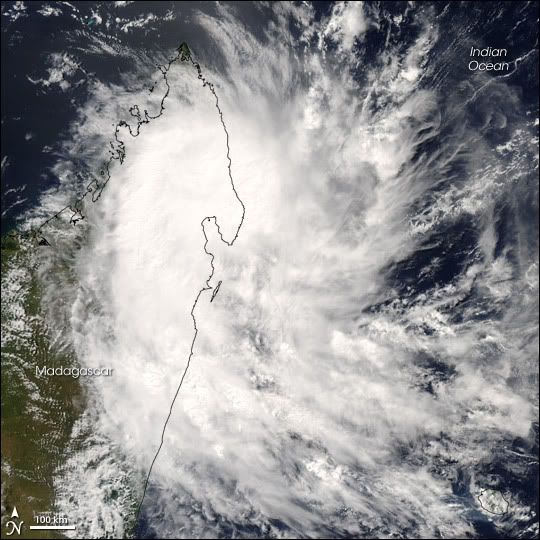
Cyclone Indlala came ashore on the island of Madagascar on March 15, 2007, as a Category 3 storm, according to data provided by the Joint Typhoon Warning Center. The storm was the country’s sixth hit of the 2006-2007 storm season. This image from the Moderate Resolution Imaging Spectroradiometer (MODIS) on NASA’s Terra satellite shows Indlala draped over the northern part of the island. Bands of swirling clouds spiral around the eye of the storm.
According to Reuters AlertNet news service, Madagascar’s emergency response resources were taxed to their limit in early March 2007 as a result of extensive flooding in the North, drought and food shortages in the South, and three previous hits from cyclones in the preceding few months: Bondo in December 2006, Clovis in January 2007, and Gamede in February. The arrival of Indlala interrupted emergency relief efforts and worsened an already difficult situation.
Forecasters: Active Atlantic Season
MIAMI (Reuters) - The Atlantic hurricane season will be exceptionally active this year, according to a British forecasting group, raising the possibility that killer storms like Hurricane Katrina could again threaten the United States.
London-based forecaster Tropical Storm Risk on Tuesday said the six-month season, which begins on June 1, was expected to bring 17 tropical storms, of which nine will strengthen into hurricanes with winds of at least 74 miles per hour.
Four of those are expected to become more destructive "intense" hurricanes, TSR said.
The long-term average for the Atlantic is for 10 storms to form during the hurricane season and for six of those to reach hurricane strength.
The United States emerged unscathed from the 2006 season after it spawned a below-average nine storms, of which five became hurricanes. Experts had universally -- and erroneously -- predicted 2006 would be a busy year for Atlantic storms.
None of the hurricanes hit the United States, bringing welcome relief to beleaguered residents of the U.S. Gulf Coast, where Katrina killed 1,500 people, swamped New Orleans and caused about $80 billion in damage the year before.
But TSR said current and projected climate signals indicate that Atlantic basin and U.S. landfalling hurricane activity will be 75 percent above the 1950-2006 average in 2007.
TSR had predicted in December that Atlantic basin and U.S. landfalling hurricane activity would be just 60 percent above average this year. It raised the projected activity level because of the sudden dissipation in February of last year's El Nino weather phenomenon
An unusual warming of the eastern Pacific waters, El Nino events tend to suppress Atlantic storm activity.
Other experts, including hurricane forecast pioneer Dr. William Gray and his team at Colorado State University, have also warned that the 2007 hurricane season is likely to be busier-than-average.
The relative calm of last year's hurricane season, which forecasters had mistakenly predicted would be busy, came on the heels of a record 28 storms and 15 hurricanes in 2005 and only a slightly less furious season in 2004.(Reuters)
Veel doden op Madagaskar door cycloon
ANTANANARIVO - De cycloon Indlala die vorige week een spoor van vernielingen trok over het eiland Madagaskar heeft tientallen levens geëist. Tienduizenden mensen in het noorden van het land zijn verdreven door het natuurgeweld, meldde de regeringsfunctionaris verantwoordelijk voor rampensbestrijding vrijdag.
„Ik heb nog nooit zo veel schade gezien”, aldus Jacky Randimbiarison. Twee mensen zouden nog worden vermist. In het district Ambanja stortte een hele berg in op twee dorpen. De nederzettingen zijn begraven onder duizenden tonnen steen. Twintig mensen onder wie zes kinderen kwamen om in een school.
Het Internationale Rode Kruis heeft een noodoproep gedaan voor bijna 500.000 euro aan giften. Het geld is nodig voor het lenigen van de eerste nood. Honderdduizenden mensen zouden getroffen zijn door het natuurgeweld.


Tropical Cyclone Kara
Tropical Cyclone Kara was poised just offshore of the Pilbara coast of Western Australia on March 27, 2007. Kara was not a particularly severe storm, but was hitting in the same area that Cyclone George, a much more powerful storm, and Cyclone Jacob, a smaller Category 2 storm similar to Cyclone Kara, had struck two weeks earlier.
This photo-like image was acquired by the Moderate Resolution Imaging Spectroradiometer (MODIS) on the Terra satellite on March 27, 2007, at 10:25 a.m. local time (02:25 UTC). The storm was a tropical cyclone with a circular shape and distinct eye at its center. According to the University of Hawaii’s Tropical Storm Information Center, Cyclone Kara had sustained winds of 145 kilometers per hour (90 miles per hour) at the time this image was acquired.

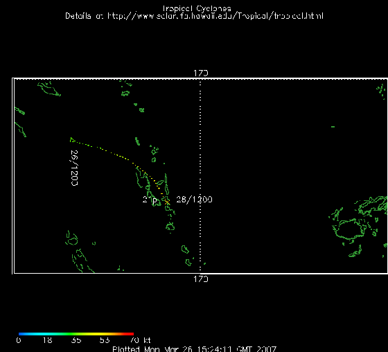
Waar ligt dat systeem momenteel?quote:Op woensdag 28 maart 2007 09:16 schreef Frutsel het volgende:
21P is inmiddels 'geupgrade' naar BECKY
[afbeelding]
Jep, op zo'n beetje dezelfde lokatie als waar van de week die aardbeving was.quote:Op woensdag 28 maart 2007 12:35 schreef highway101 het volgende:
Dat is volgens mij bij Vanuatu en New Caledonia, een eind ten oosten van Australië
Toeval? DE ---> TRU
Madagaskar zet zich schrap voor zesde cycloon
ANTANANARIVO (ANP) - Ongeveer 450.000 personen zijn sinds december 2006 getroffen door een serie van vijf cyclonen in Madagaskar. De zesde cycloon Jaya bereikt binnen 24 uur de noordkust van het eiland, dat ten oosten van het Afrikaanse vasteland ligt.
Drie weken geleden eiste de cycloon Indlala al tientallen levens. Duizenden mensen werden verdreven door het natuurgeweld.
Infrastructuur, scholen en ziekenhuizen in Madagaskar zijn beschadigd. Er is een enorm tekort aan voedsel, water en medicatie voor de inwoners van het land, meldde het VN-kinderfonds Unicef maandag.
6x in 4 maanden tijd.quote:Op maandag 2 april 2007 17:53 schreef Frutsel het volgende:
Madagaskar zet zich schrap voor zesde cycloon
ANTANANARIVO (ANP) - Ongeveer 450.000 personen zijn sinds december 2006 getroffen door een serie van vijf cyclonen in Madagaskar. De zesde cycloon Jaya bereikt binnen 24 uur de noordkust van het eiland, dat ten oosten van het Afrikaanse vasteland ligt.
Drie weken geleden eiste de cycloon Indlala al tientallen levens. Duizenden mensen werden verdreven door het natuurgeweld.
Infrastructuur, scholen en ziekenhuizen in Madagaskar zijn beschadigd. Er is een enorm tekort aan voedsel, water en medicatie voor de inwoners van het land, meldde het VN-kinderfonds Unicef maandag.
Elke keer duurt het project van herstelwerkzaamheden weer een beetje langer omdat materialen alsook het werkgereedschap weggewaaid is.
Buitengewoon actief orkaanseizoen voorspeld
Orkaanexperts voorspellen voor dit jaar een buitengewoon actief orkaanseizoen.
Verwoestend
Rekening wordt gehouden met zeker 17 tropische stormen in het Caribisch gebied en Midden- en Noord-Amerika. Zeker vijf stormen groeien uit tot orkanen, stelt orkaanexpert William Gray. Volgens hem is er een kans van 74% dat er in elk geval één verwoestende orkaan de Amerikaanse kust keihard zal treffen.
Seizoen
Het orkaanseizoen loopt in het gebied van de Atlantische Oceaan van juni tot november. Vorig jaar waren er negen tropische stormen, waarvan vijf orkanen. 2005 was een recordjaar met 28 stormen, waarvan 15 orkanen.
-
Tropical Cyclone Jaya
Tropical Cyclone Jaya came ashore in Northern Madagascar in the morning of April 2, 2007 at around 11:00 am local time (08:00 UTC). The storm formed in the Indian Ocean on March 30 and travelled westward toward Madagascar as predicted. What was not predicted, however, was its explosive growth in power from a strong tropical storm to a powerful Category 3 cyclone in just 36 hours, according to figures provided by the University of Hawaii’s Tropical Storm Information Center. Fortunately all this alarming action took place while Jaya was still well out from Madagascar over the ocean, and it struck land after losing power. Sustained winds at landfall were around 150 kilometers per hour (90 miles per hour), a marked change from 200 km/hr (125 mph) just twelve hours earlier. While much weakened, Jaya remained a powerful storm. Furthermore, it struck the northern part of Madagascar where a series of other cyclones in recent months have also come ashore. Forecasters were concerned that Jaya might reform after crossing the island and head inland into Mozambique where residents are recovering from floods caused by recent heavy rains.
This photo-like image was acquired by the Moderate Resolution Imaging Spectroradiometer (MODIS) on the Aqua satellite on April 3, 2007, at 1:15 p.m. local time (10:15 UTC). The storm was a tropical cyclone with a circular shape, but no distinct eye at its center. According to the University of Hawaii’s Tropical Storm Information Center, Cyclone Jaya’s sustained winds had fallen in strength to roughly 125 km/hr (80 mph) at the time this image was acquired.
De Nederlanders worden wakker... hoewel op 23 maart al door de Amerikanen een melding werd gemaakt over een 'Active Season'... volgt nu Nederland
===============================================================
Dekundigen waarschuwen voor orkanen
Deskundigen verwachten dit jaar een zeer actief Atlantisch orkaanseizoen. Volgens een bekendmaking dinsdag door een onderzoeksteam van de universiteit van Colorado wordt uitgegaan van negen orkanen. Eén zware orkaan zal hoogstwaarschijnlijk de kust van de Verenigde Staten bereiken.
De experts voorspellen zeventien tropische stormen die krachtig genoeg zullen zijn om een naam te verdienen, waaronder vijf zware orkanen. De kans dat een daarvan de Amerikaanse kust bereikt is dit jaar 74 procent.
Vorig jaar voorspelden het onderzoekscentrum en het Amerikaanse Nationale Orkaancentrum meer tropische stormen dan zich in werkelijkheid voordeden. In 2006 waren tien stormen krachtig genoeg om een naam te krijgen en deden zich vijf orkanen voor, waarvan twee zware. Het Atlantische orkaanseizoen loopt van 1 juni tot 30 november.
Tragisch orkaanseizoen voor Madagaskar
Gisteren is opnieuw een tropische cycloon, Jaya, op het eiland Madagaskar aan land gekomen. Het is al de zesde cycloon in de zuidwestelijke Indische Oceaan die het eiland dit seizoen 2006/2007 treft: vier kwamen aan land (Bondo, Clovis, Indlala en nu dus Jaya) en twee scheerden langs het eiland (Favio en Gamede).
De cyclonen hebben samen enkele honderden mensenlevens gekost en tienduizenden zijn dakloos. Volgens UNICEF ondervinden bijna een half miljoen mensen grote problemen, wegens gebrek aan voedsel, water en medicijnen. Tienduizenden hectaren aan rijstvelden zijn verloren gegaan.
vwk
En ook Cliff duikt op in de verre uithoek... erges ten noord oosten van de Solomon Eilanden en Nieuw Zeeland
Dode door tropische storm in Fiji
De tropische storm Clive die bij Fiji is ontstaan, heeft aan één persoon het leven gekost. Het noodweer liet een behoorlijk schade achter.
Regen en windkracht 10 zorgden voor noodweer. Op een eiland in het oosten van het eilandenrijk viel 190 millimeter neerslag. Een 30-jarige vrouw die een snelstromende rivier probeerde over te steken, kwam daarbij om het leven.
VWK
Madagascar's Cyclone Season
When Cyclone Jaya came ashore over northern Madagascar on April 2, 2007, it was the fourth cyclone to do so since December 2006. Three other cyclones passed near enough to drench the southern African island nation. Two weeks before Jaya struck, Cyclone Indlala cut across the island. Favio and Gamede brought rain to the region in February, and Clovis, Bondo, and Anita all struck Madagascar in December. The cumulative effect of the seven cyclones was widespread flooding and displacement in the northern half of the country, reported the United Nations Office for the Coordination of Humanitarian Affairs (OCHA).
This pair of images shows the rainfall the storms brought to the region as recorded by the Tropical Rainfall Measuring Mission (TRMM) satellite. The top image compares rainfall totals from December 1, 2006, to April 5, 2007, with the average totals recorded between 1996 and 2006. The anomaly reveals that northern Madagascar and parts of mainland Africa received more rain than normal, particularly along the tracks of the storms. The southern half of Madagascar was in extreme drought, which is also illustrated by this image. The pale yellow regions indicate where less rain fell than normal.
The lower image illustrates rainfall totals from November 30, 2006, when Cyclone Anita formed, to April 5, 2007, as Cyclone Jaya was dissipating. The highest rainfall is shown in red and is concentrated in northern Madagascar where the storms came ashore. During this five-month period, TRMM recorded up to 790.6 millimeters (31.1 inches) of rain off the north coast of Madagascar.
Bron:
New FEMA Hurricane Plan Won't Be Ready click
Congress Ordered New Plan By June 1; Agency Says Still Hopes for Sometime in June
April 17, 2007
(CBS/AP)
Congress Ordered New Plan By June 1; Agency Says Still Hopes for Sometime in June
April 17, 2007
(CBS/AP)
quote:A federal government plan for responding to emergencies will not be ready in time for the approaching hurricane season, officials have told Congress.
Laat het maar beginnen!quote:Hello again, and welcome to the National Hurricane Center Automated
Advisory Email Service. In preparation for the start of the 2007
Hurricane Season, we will be resuming our Automated Advisory Email
Service shortly. The East Pacific season begins May 15th and the
Atlantic season begins June 1st.
/ ¦ ¦ / ¦ ¦

Grotere kans op orkanen in Louisiana(Trouw)
HOUSTON (ANP) - De kans dat de Amerikaanse staten Texas, Louisiana en Mississippi dit jaar door zware wervelstormen worden getroffen, is boven gemiddeld. Dit stelde dinsdag een prominente instelling als het gaat om wervelstormvoorspellingen, de Colorado State University.
De kans op orkanen met windsnelheden van meer dan 175 kilometer per uur is in de streek langs de Golf van Mexico normaal 30 procent. Dit jaar is het 49 procent volgens orkaanvoorspeller Phillip Klotzbach.
De kusten van Lousiana, inclusief de stad New Orleans, en die van Mississippi werden in 2005 door de orkaan Katrina voor een groot deel verwoest. De schade bedroeg meer dan 80 miljard dollar.
An Early Start of the Season? Did we "Miss" Andrea??
I was just looking at some observations from a buoy that is located about 180 miles east of Cape Hatteras, North Carolina. Winds at this buoy have been above tropical storm strength (>39 mph) throughout the day.
The interesting thing to me though are the wave heights. Operationally, NHC warns of a 12-ft wave height radius for named systems, that is how far from the center of the storm does one find 12-ft high waves. Have a look below at the wave heights generated by this system. Pretty impressive.
Alas, looking at the latest model runs, this is most likely the height of the storm's intensity, so if NHC has not upgraded the system yet, it most likely will not. Still, this storm will be a significant rain/wind/surge event for the Southeast Coast, with hurricane force wind warnings posted off the South Carolina coast. If anything else happens with the storm, we'll try to get it posted here.
A strong low pressure system has formed off the East Coast of the United States (Figure 1). This system has developed central thunderstorm activity while remaining over the warmish waters of the Gulf Stream. Sea surface temperatures underneath the area of activity are below the usual threshold of 26C, however, upper level temperatures are cold enough that the storm could develop some tropical characteristics.
The forecast track moves it southwestward over the next few days. I'm showing the UKMET model here because it has been the most consistent and best forecast for this storm (Figure 2). To my eye, this looks like classical subtropical development.
Rest van het artikel ----> http://www.thestormtrack.(...)rt_to_the_season.php
en http://www.thestormtrack.com/
===============
Dat zou wat zijn... als ze 'nu al' een storm hadden... normaal is Juni nog relatief rustig... maar in Mei??
[ Bericht 10% gewijzigd door Frutsel op 09-05-2007 10:25:55 ]
I was just looking at some observations from a buoy that is located about 180 miles east of Cape Hatteras, North Carolina. Winds at this buoy have been above tropical storm strength (>39 mph) throughout the day.
The interesting thing to me though are the wave heights. Operationally, NHC warns of a 12-ft wave height radius for named systems, that is how far from the center of the storm does one find 12-ft high waves. Have a look below at the wave heights generated by this system. Pretty impressive.
Alas, looking at the latest model runs, this is most likely the height of the storm's intensity, so if NHC has not upgraded the system yet, it most likely will not. Still, this storm will be a significant rain/wind/surge event for the Southeast Coast, with hurricane force wind warnings posted off the South Carolina coast. If anything else happens with the storm, we'll try to get it posted here.

A strong low pressure system has formed off the East Coast of the United States (Figure 1). This system has developed central thunderstorm activity while remaining over the warmish waters of the Gulf Stream. Sea surface temperatures underneath the area of activity are below the usual threshold of 26C, however, upper level temperatures are cold enough that the storm could develop some tropical characteristics.
The forecast track moves it southwestward over the next few days. I'm showing the UKMET model here because it has been the most consistent and best forecast for this storm (Figure 2). To my eye, this looks like classical subtropical development.


Rest van het artikel ----> http://www.thestormtrack.(...)rt_to_the_season.php
en http://www.thestormtrack.com/
===============
Dat zou wat zijn... als ze 'nu al' een storm hadden... normaal is Juni nog relatief rustig... maar in Mei??
[ Bericht 10% gewijzigd door Frutsel op 09-05-2007 10:25:55 ]

bron: NHC mail.quote:...EARLY-SEASON SUBTROPICAL STORM FORMS OFF THE SOUTHEAST U.S.
COAST...
SATELLITE IMAGERY AND AIRCRAFT DATA INDICATE THAT THE LOW PRESSURE
SYSTEM OFF THE SOUTHEAST U.S. COAST HAS ACQUIRED SUBTROPICAL
CHARACTERISTICS.
AT 11 AM EDT...1500 UTC...A TROPICAL STORM WATCH HAS BEEN ISSUED
ALONG THE SOUTHEAST COAST OF THE UNITED STATES FROM ALTAMAHA SOUND
GEORGIA SOUTHWARD TO FLAGLER BEACH FLORIDA. A TROPICAL STORM WATCH
MEANS THAT TROPICAL STORM CONDITIONS ARE POSSIBLE WITHIN THE WATCH
AREA...GENERALLY WITHIN THE NEXT 36 HOURS.
/ ¦ ¦ / ¦ ¦
ff achter de schermen gevraagd hoe we DE gaan koppelen met NWS met het oog op het komende seizoen. Eens kijken of de vaste Hurricane lezers en posters ook in NWS de anderen voor kunnen zijn met het verstrekken van info Kom ik nog ff op terug

Jeumig nu al. Is dit alle energie die de oceaan vorig jaar niet kwijt kon omdat er gewoon nooit echt geschikte omstandigheden waren voor orkanen? Dan hebben we een lollig jaar voor de boeg.
Puntje van orde trouwens: Zelf heb ik voor het nalezen liever dat er statische plaatjes meegelinkt worden in de discussie ipv dingen die constant ververst worden door de NOAA. Maakt het nalezen van de discussie over een week een stuk makkelijker.
Puntje van orde trouwens: Zelf heb ik voor het nalezen liever dat er statische plaatjes meegelinkt worden in de discussie ipv dingen die constant ververst worden door de NOAA. Maakt het nalezen van de discussie over een week een stuk makkelijker.
^^^ dat lijkt me inderdaad een goed plan. Straks heb je een discussie die leest over een orkaan die al dissipated is.
/ ¦ ¦ / ¦ ¦
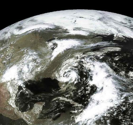


Andrea Winds speeds up Wildfires in Georgia and Florida
Winds from the first named storm of the year fanned wildfires in Georgia and northern Florida on Wednesday, more than three weeks ahead of the official start of the Atlantic hurricane season.
Subtropical Storm Andrea, with maximum sustained winds of 45 mph (72 kph) and higher gusts, was centered about 135 miles southeast of Savannah, Georgia, and about 115 miles northeast of Daytona Beach, Florida, as of 11 p.m. ET on Wednesday, forecasters said.
Tropical storm-force winds extended outward up to 105 miles from its center, mainly to the east.
Forecasters had described Andrea as "meandering" throughout the day, but late Wednesday said it was nearly stationary and that no significant motion was expected in the next 24 hours.
A tropical storm watch was issued for the Southeastern U.S. coast from Georgia's Altamaha Sound south to Flagler Beach, Florida, the weather service said.
A tropical storm watch means that tropical storm conditions are possible within 36 hours.
A previous forecast warned of dangerous surf conditions along the coasts of North and South Carolina as well as Georgia and northeastern Florida.
The storm is expected to bring a total of 1-2 inches of rain along the coast, with isolated maximum amounts of about 3 inches in some rainbands, forecasters said.
Rain will be welcomed in southern Georgia and northern Florida, where drought conditions have contributed to wildfires. In fact, Andrea's winds were making things worse Wednesday.
"Our forestry firefighters think they have [one fire] contained, and then these winds blow an ember a mile away and start a fire over there," said Terence McElroy, a spokesman for the Florida Department of Agriculture and Consumer Services.
Florida Gov. Charlie Crist, who declared a state of emergency in the state May 3 because of the drought and wildfire danger, deployed the National Guard to help contain the blazes.
Wednesday, he traveled to several areas where 220 wildfires are burning 80,000 acres (32,370 hectares), hoping for Andrea to bring much-needed rain.
"I just hope it's wet. I want it to be wet, and I want it to come in here. I want it to come in as soon as it can," he said.
Fires are burning in 54 of the drought-ravaged state's 67 counties. Florida officials issued recommendations on Wednesday advising residents to stay indoors whenever possible to avoid the smoke drifting across the state.
Since the beginning of the year, 2,139 fires have burned more than 195,000 acres (78,900 hectares) in Florida, according to the Department of Agriculture and Consumer Services Web site.
In south Georgia, more than 156,000 acres (63,000 hectares) have burned in four counties.
The biggest fire, in Ware and Charlton counties, began April 16 when a power line went down. Schools were closed Wednesday in Charlton County.
Mandatory evacuations have been issued for about 300 homes in the town of Moniac and 20 homes in Davis.
Arson investigators were still looking for a black, extended-cab, late-90s Chevrolet pickup truck driven by an arson witness, officials said.
Subtropical storms differ from tropical storms in some technical characteristics relating to wind and temperature, according to the National Hurricane Center's Web site.
Hurricane season begins June 1. (CNN)

Subtropical Storm Andrea
The circling clouds of an intense low-pressure system sat off the southeast coast of the United States on May 8, 2007, when the Moderate Resolution Imaging Spectroradiometer (MODIS) on NASA’s Terra satellite captured this image. By the following morning, the storm developed enough to be classified as a subtropical storm, a storm that forms outside of the tropics, but has many of the characteristics—hurricane-force winds, driving rains, low pressure, and sometimes an eye—of a tropical storm.
Although it arrived several weeks shy of the official start of the hurricane season (June 1), Subtropical Storm Andrea became the first named storm of the 2007 Atlantic hurricane season. The storm has the circular shape of a tropical cyclone in this image, but lacks the tight organization seen in more powerful storms. By May 9, the storm’s winds reached 75 kilometers per hour (45 miles per hour), and the storm was not predicted to get any stronger, said the National Hurricane Center.
Though Subtropical Storm Andrea was expected to remain offshore, its strong winds and high waves pummeled coastal states, prompting a tropical storm watch. The winds fueled wild fires (marked with red boxes) in Georgia and Florida. The wind-driven flames generated thick plumes of smoke that concentrated in a gray-brown mass over Tampa Bay, Florida. Unfortunately for Georgia and Florida, which are experiencing moderate to severe drought, Subtropical Storm Andrea was not predicted to bring any significant rain to the region in upcoming days, according to reports on the Washington Post Website.
Andrea is er vroeg bij
Ter hoogte van de Amerikaanse zuidoostkust (nabij Florida) is gisteren de eerste (sub)tropische storm van het seizoen tot ontwikkeling gekomen. Het systeem kreeg de naam Andrea. (sub)Tropische stormen in deze tijd van het jaar komen niet vaak voor maar uniek zijn ze niet. In onder meer mei 1889 en in mei 1951 zijn er tropische stormen geweest en zelfs op 7 maart in het jaar 1908. De vroegste tropische cycloon die de Amerikaanse oostkust (het noorden van Florida) bereikte was Alma op 24-25 mei 1970. Alma kostte op Cuba aan zeven mensen het leven maar werd in Florida met open armen ontvangen omdat het systeem met tussen 125 en 250 mm een einde maakte aan de droogte in het zuiden van deze staat. De schade had daar niets te betekenen en doden en gewonden vielen er niet te betreuren. In juni 1966 was er ook een Alma actief: dit systeem bereikte het noordwesten van Florida op de 9de en was de vroegste hurricane die de Amerikaanse kustlijn passeerde.
Ter hoogte van de Amerikaanse zuidoostkust (nabij Florida) is gisteren de eerste (sub)tropische storm van het seizoen tot ontwikkeling gekomen. Het systeem kreeg de naam Andrea. (sub)Tropische stormen in deze tijd van het jaar komen niet vaak voor maar uniek zijn ze niet. In onder meer mei 1889 en in mei 1951 zijn er tropische stormen geweest en zelfs op 7 maart in het jaar 1908. De vroegste tropische cycloon die de Amerikaanse oostkust (het noorden van Florida) bereikte was Alma op 24-25 mei 1970. Alma kostte op Cuba aan zeven mensen het leven maar werd in Florida met open armen ontvangen omdat het systeem met tussen 125 en 250 mm een einde maakte aan de droogte in het zuiden van deze staat. De schade had daar niets te betekenen en doden en gewonden vielen er niet te betreuren. In juni 1966 was er ook een Alma actief: dit systeem bereikte het noordwesten van Florida op de 9de en was de vroegste hurricane die de Amerikaanse kustlijn passeerde.
Als die mooie orkaantjes nou ook eens richting NL komen, die hier voor leuke stormen gaat zorgen, dan vind ik het wel best
Maar het is idd behoorlijk vroeg, maar betekent ook een zeer actief topic seizoen
Maar het is idd behoorlijk vroeg, maar betekent ook een zeer actief topic seizoen
<a href="https://www.youtube.com/channel/UCPueUwKfPaGH7v48LZlltkg" rel="nofollow" target="_blank">WSDokkum Youtube</a>
Ja jij bent gek weet je wel hoe koud dat, dat is. maar eerlijk is eerlijk het is al erg genoeg
Goudenkooi verslaafde!!
Idd, het is niet leuk om een orkaan over je heen te krijgen met alle gevolgen van dien......maar een keer moet toch wel eens kunnen want zeg nou eens eerlijk, super zwaar weer hebben we hier niet
<a href="https://www.youtube.com/channel/UCPueUwKfPaGH7v48LZlltkg" rel="nofollow" target="_blank">WSDokkum Youtube</a>
Beetje te koud water hier he . Misschien als het IJselmeer flink opwarmt Of nog beter, het Tjeukemeerquote:Op donderdag 10 mei 2007 22:50 schreef SpeedyGJ het volgende:
Als die mooie orkaantjes nou ook eens richting NL komen, die hier voor leuke stormen gaat zorgen, dan vind ik het wel best
Maar het is idd behoorlijk vroeg, maar betekent ook een zeer actief topic seizoen
Noordzee is al warm genoeg voor een goed stormpie denk eens aan 18 januari herhaling mag wel of die van 1 novquote:Op donderdag 10 mei 2007 23:16 schreef i2Them2 het volgende:
[..]
Beetje te koud water hier he . Misschien als het IJselmeer flink opwarmt Of nog beter, het Tjeukemeer
<a href="https://www.youtube.com/channel/UCPueUwKfPaGH7v48LZlltkg" rel="nofollow" target="_blank">WSDokkum Youtube</a>
hoezo 'koud' ?quote:Op donderdag 10 mei 2007 23:09 schreef annatopia het volgende:
Ja jij bent gek weet je wel hoe koud dat, dat is. maar eerlijk is eerlijk het is al erg genoeg
Westen winden zorgen altijd voor frissere lichtquote:
Graagquote:Op vrijdag 11 mei 2007 11:15 schreef annatopia het volgende:
gj daar heb je wel gelijk in maar dan wel bij jou in de buurt niet bij ons
Maar goed, effe verder ontopic zus
Ben eigelijk wel benieuwd hoe dit allemaal gaat uit pakken. Als ik het zo allemaal een beetje lees, kan het wel weer eens goed mis gaan daar. Orkaan katrina heb ik toen helemaal live op CNN gevolgt, misschien dat het dit jaar wel weer wordt
<a href="https://www.youtube.com/channel/UCPueUwKfPaGH7v48LZlltkg" rel="nofollow" target="_blank">WSDokkum Youtube</a>
Speedy, Mag ik u voor augustus/september een tripje Florida aanraden? Of Japan of de Filipijnen ofzo.
Het spul is fantastisch mooi om te zien, ik ben iedere keer weer verbaasd hoeveel warmte en vocht er door 1 lullig stormpje getransporteerd kan worden en hoe belangrijk die dingen zijn voor de warmte huishouding van de aarde, maar ik hoef ze niet mee te maken.
Nederland is gematigd. Nooit te warm, te koud, te nat, te droog, te links of te rechts. Nou ja, dat laatste niet meer, maar die eerste wil ik graag nog even zo houden
Als jij mij geld gaat sponseren, dan zal ik voor zorgen dat een er een knallende verslag + filmpjes etc etc etc op mijn website komt te staan
<a href="https://www.youtube.com/channel/UCPueUwKfPaGH7v48LZlltkg" rel="nofollow" target="_blank">WSDokkum Youtube</a>
Kan zijn, maar zo'n orkaan wordt mede gevoed door warm zeewater...dus voordat dat hier gerealiseerd is, vraag ik me af hoe koud het dan nog is.. dan gaat immers alles op zijn gat toch?quote:Op vrijdag 11 mei 2007 11:17 schreef SpeedyGJ het volgende:
[..]
Westen winden zorgen altijd voor frissere licht
[..]
Juist, maar het komt ook weer over koude zeewater dan moet je denken aan temps van 20/21 graden, met regen en wind natuurlijk maar dit hangt ook weer vanaf hoe warm de bovenlucht is.quote:Op vrijdag 11 mei 2007 11:27 schreef Frutsel het volgende:
[..]
Kan zijn, maar zo'n orkaan wordt mede gevoed door warm zeewater...dus voordat dat hier gerealiseerd is, vraag ik me af hoe koud het dan nog is.. dan gaat immers alles op zijn gat toch?
<a href="https://www.youtube.com/channel/UCPueUwKfPaGH7v48LZlltkg" rel="nofollow" target="_blank">WSDokkum Youtube</a>

tvp
LastFM
03/06 Maccabees - 10/06 Gaslight Anthem - 18/06 Oi Vai Voi - 20/06 Green Beats - 24/06 Ghinzu - 18/07 Extrema Outdoor
03/06 Maccabees - 10/06 Gaslight Anthem - 18/06 Oi Vai Voi - 20/06 Green Beats - 24/06 Ghinzu - 18/07 Extrema Outdoor
Een tijd geleden was er ook een orkaan bij zuid Brazilië. Dat was daar net zo ongewoon als hier meen ik.
/ ¦ ¦ / ¦ ¦
Andrea still not reformed
May 13, 2007 - 2:25 AM UTC (subtract 4 hours for EDT - StormTrack)
As a quick update, the remnants of Andrea have still not reformed into a tropical depression. Flares of convection have been continuously firing up and subsiding all day long. Once again, if Andrea can sustain convection in one spot and organize a bit more at all, she will regain tropical depression status.


CNN meldde Vietnam, nam het klakkeloos overquote:Op maandag 14 mei 2007 15:41 schreef highway101 het volgende:
Vietnam?
Bangladesh/Myanmar(Burma) en India bedoel je
maar je hebt gelijk
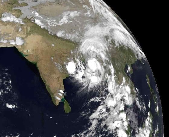
Andrea en rook van bosbranden
On Saturday, as the remnants of Andrea finally began moving out to sea, the tropical depression-ish low fired sporadic bursts of convection like the one near its center in the first image below, but overall the convection over the course of the weekend was never really persistent in an organized fashion and the system was not officially designated by the National Hurricane Center to be a depression. Today, as it moved farther northeast, the low started becoming less well-defined and is now merging with a cold front and becoming extratropical (as it was when everything began a week ago!).
Meanwhile, the fires keep burning, and the smoke persists from south Georgia and the eastern Gulf of Mexico across Florida and now even farther out into the Atlantic. On the second image below, there's a particularly dense concentration of smoke near the Georgia/Florida border in the area where road closures have resulted in slow-going for travelers. Hopefully the thunderstorms that have been scattered about the region at times this weekend have done more good (rain) than harm (wind and lightning).
weather.com (hier is ook een grotere foto te vinden)
[ Bericht 3% gewijzigd door #ANONIEM op 14-05-2007 21:58:58 ]
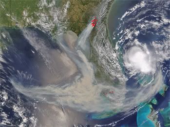
De cycloon Akash is gepromoveerd tot een catogorie 1 ! Dat is de eerste sinds lange tijden !!

2007 = Supper orkaan zeisoen !
Dat gebied bij Chittagong valt toch altijd de meeste neerslag ter wereld? Dat wordt nu dus meer
/ ¦ ¦ / ¦ ¦
Leuke naam, wat voor superkloon ben jij?quote:Op maandag 14 mei 2007 23:02 schreef Catogorie5 het volgende:
De cycloon Akash is gepromoveerd tot een catogorie 1 ! Dat is de eerste sinds lange tijden !!
[afbeelding]
Hurricane Forecast 2007: Florida in the Bulls-eye This Season click
We're in for a Rough Year Says — Joe Bastardi, Chief Hurricane Forecaster for AccuWeather
May 14, 2007
AccuWeather.com
benieuwd wat het wordt, want niets is zeker...
[ Bericht 3% gewijzigd door francorex op 16-05-2007 21:57:13 ]
We're in for a Rough Year Says — Joe Bastardi, Chief Hurricane Forecaster for AccuWeather
May 14, 2007
AccuWeather.com
...quote:AccuWeather.com Chief Hurricane Forecaster Joe Bastardi and his team expect this season's hurricanes and tropical storms to pose a far greater threat to lives and property than last year's, with significantly more storms striking the U.S.
In the AccuWeather.com 2007 Hurricane Season Forecast released recently, Bastardi warns that six or seven storms will strike the U.S. coast. This includes the possibility of multiple strikes by the same storm, such as the way hurricanes Andrew and Katrina, both extreme examples, struck Florida before later striking the Gulf Coast. The majority of these landfalls are projected for the Gulf Coast from the mouth of the Mississippi River to Cape Hatteras, N.C., with the center of the bull's-eye on Florida.
AccuWeather.com forecasts 13 or 14 total storms in the Atlantic basin, with three or more likely to be major hurricanes of category 3 or greater.

benieuwd wat het wordt, want niets is zeker...
quote:In summarizing what can be expected this summer, Bastardi said, "We are living in a time of climatic hardship. We're in a cycle where weather extremes are more the norm and not the exception.
[ Bericht 3% gewijzigd door francorex op 16-05-2007 21:57:13 ]
Hoeso ?quote:Op maandag 14 mei 2007 23:21 schreef Frutsel het volgende:
[..]
Leuke naam, wat voor superkloon ben jij?
Er zijn trouwens ongeveer 100 doden gevallen bij de cycloon !
2007 = Supper orkaan zeisoen !
Ach dat zeiden ze vorig jaar ook en toen bleef het rustig.quote:Op woensdag 16 mei 2007 01:07 schreef francorex het volgende:
Hurricane Forecast 2007: Florida in the Bulls-eye This Season
We're in for a Rough Year Says — Joe Bastardi, Chief Hurricane Forecaster for AccuWeather
May 14, 2007
AccuWeather.com
[..]
...
benieuwd wat het wordt, want niets is zeker...
[..]
Zoals ik zei, niets is zeker.quote:Op woensdag 16 mei 2007 15:15 schreef Eveli het volgende:
[..]
Ach dat zeiden ze vorig jaar ook en toen bleef het rustig.
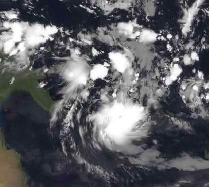
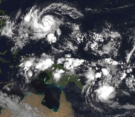
YUTU
Actuele status
Om 15h00 UTC, op 18 mei bevond zware tropische storm Yutu zich nabij 13,6 Noorderbreedte, 133,3 Oosterlengte, oftewel 700 km ten noordwesten van Yap. Yutu trekt met 26 km/uur in noordwestelijke richting en gaat gepaard met windsnelheden tot 110 km/uur (10 min), tot 120 km/uur (1 min) en met windstoten tot 157 km/uur. De minimale luchtdruk bedraagt 985 hPa. Verwacht wordt, dat Yutu verder zal aanwakkeren tot tyfoon.
[ Bericht 74% gewijzigd door #ANONIEM op 18-05-2007 23:34:27 ]
Actuele status
Om 15h00 UTC, op 18 mei bevond zware tropische storm Yutu zich nabij 13,6 Noorderbreedte, 133,3 Oosterlengte, oftewel 700 km ten noordwesten van Yap. Yutu trekt met 26 km/uur in noordwestelijke richting en gaat gepaard met windsnelheden tot 110 km/uur (10 min), tot 120 km/uur (1 min) en met windstoten tot 157 km/uur. De minimale luchtdruk bedraagt 985 hPa. Verwacht wordt, dat Yutu verder zal aanwakkeren tot tyfoon.
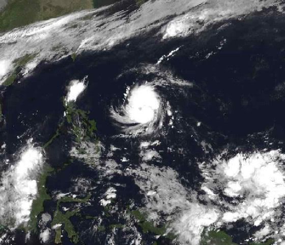
[ Bericht 74% gewijzigd door #ANONIEM op 18-05-2007 23:34:27 ]
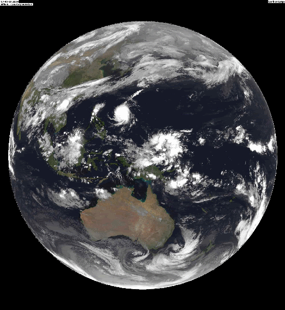
Actuele status (YUKU)
Om 09h00 UTC, op 19 mei bevond tyfoon Yutu zich nabij 16,7 Noorderbreedte, 132,2 Oosterlengte, oftewel 1020 km ten noordwesten van Yap. Yutu trekt met 20 km/uur in noordlijke richting en gaat gepaard met windsnelheden tot 148 km/uur (10 min), tot 157 km/uur (1 min), en met windstoten tot 213 km/uur. De minimale luchtdruk bedraagt 965 hPa. Verwacht wordt, dat Yutu de komende dagen nog iets in kracht zal toenemen en zal ombuigen naar het noordoosten, waarna Yutu gestaag zal verzwakken.
[ Bericht 8% gewijzigd door #ANONIEM op 20-05-2007 00:05:28 ]
Woei 157km/h kom maar hier heen, dat kan NL nog wel hebben alleen de windstoten wordt wat lastig denk ik
Wel een mooi satbeeld
Wel een mooi satbeeld
<a href="https://www.youtube.com/channel/UCPueUwKfPaGH7v48LZlltkg" rel="nofollow" target="_blank">WSDokkum Youtube</a>
YUKU heeft nu windstoten van 275 km/uur. Na morgen zal de tyfoon afzwakken. (dan komt het in kouder water terecht)
Hier is ook het oog mooi te zien.
Hier is ook het oog mooi te zien.
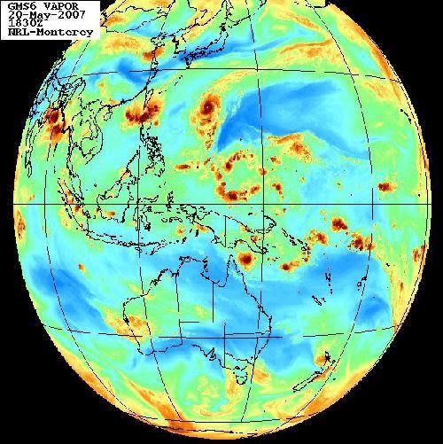
Hmm Nu al zin in zo'n orkaan restant die het hier lekker stormachtig maakt
(verkapte tvp)
(verkapte tvp)
Egregious professor of Cruel and Unusual Geography
Onikaan ni ov dovah
Onikaan ni ov dovah
Voltreffer voor Iwo Jima
Ten zuiden van Japan is de orkaan Yutu verschenen. De orkaan die zondagavond was uitgegroeid tot een categorie 4 trekt richting Iwo Jima.
De luchtdruk in het systeem was zondagavond gedaald tot 922 hPa. Rond het oog bedroeg de gemiddelde windsnelheid 220 kilometer per uur met windstoten tot 270 kilometer per uur. Volgens de huidige verwachting zal het oog maandagmiddag precies over het eiland trekken. De orkaan is dan afgenomen tot een categorie 2.

Zat gisteren al op de kaarten te bladeren naar het pad van Yutu. Iwo Jima... het enige wat ik daar van weet is de geschiedenis uit de 2e Wereldoorlog. En al die gangenstelsels zijn toen dichtgegooid Mjah, hopelijk valt het mee voor die bevolking... zal ze zwaar treffen, ook al is het 'maar' een cat.2
In tokyo gelukkig niets van te merken, hier heerlijk weer.
They told me all of my cages were mental, so I got wasted like all my potential.
Ghe ja 'maar' categorie 2. Da's altijd nog flink zwaarder dan onze januaristorm die ons land zo'n beetje ontwrichtte en waarbij iets van 6 doden vielen.quote:Op maandag 21 mei 2007 08:14 schreef Frutsel het volgende:
Zat gisteren al op de kaarten te bladeren naar het pad van Yutu. Iwo Jima... het enige wat ik daar van weet is de geschiedenis uit de 2e Wereldoorlog. En al die gangenstelsels zijn toen dichtgegooid Mjah, hopelijk valt het mee voor die bevolking... zal ze zwaar treffen, ook al is het 'maar' een cat.2
Yuku zwakt nu snel af.
Windsnelheid rond de 120 km/uur met windstoten tegen de 150 km/uur.
Hier is een grotere versie van bovenstaand plaatje
Windsnelheid rond de 120 km/uur met windstoten tegen de 150 km/uur.
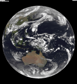
Hier is een grotere versie van bovenstaand plaatje
Experts predict 'active' hurricane season
WASHINGTON (AP) -- Government forecasters called for a busier than normal hurricane season Tuesday.
National Weather Service forecasters said they expect 13 to 17 tropical storms, with seven to 10 of them becoming hurricanes.
The forecast follows that of two other leading storm experts in anticipating a busy season.
The likelihood of above normal hurricane activity is 75 percent, the National Oceanic and Atmospheric Administration said. (Watch how storms spur the market for survival kits and hurricane armor )
"With expectations for an active season, it is critically important that people who live in East and Gulf coastal areas as well as the Caribbean be prepared," said Bill Proenza, director of the national hurricane center in Miami, Florida.
After the battering by storms Katrina and Rita in 2005 there were widespread fears last summer of another powerful storm striking, but the unexpected development of the El Nino climate phenomenon helped dampen conditions.
The El Nino has ended, however, leaving the potential for more tropical storms threatening the Gulf and East coasts.
El Nino is a warming of the tropical Pacific Ocean that occurs every few years. The warm water affects wind patterns that guide weather movement and its effects can be seen worldwide. In El Nino years, there tend to be fewer summer hurricanes in the Atlantic Ocean.
Earlier this month Philip Klotzbach, a research associate at Colorado State University, and Joe Bastardi, the chief hurricane forecaster for AccuWeather Inc., said they anticipate a more active storm cycle this year.
And, almost as if to underscore their comments, a subtropical storm formed off the southeast coast and became Andrea, the first named storm of the year, well before the June 1 official beginning of hurricane season.
Hurricane season ends November 30, but the strange season of 2005 ran into late December, using up all the planned alphabetical names and forcing storm watchers to switch to the Greek alphabet to continue naming storms.
Last year, there were just 10 tropical storms in the Atlantic and none made landfall in the United States.
Klotzbach and his colleague at Colorado State, William Gray, predict a "very active" season this year with 17 named storms, including nine hurricanes.
Bastardi called for fewer storms but agreed 2007 would be more active than usual. He expects 13 or 14 named storms, six or seven of which will strike the U.S. coast.
Bastardi said the Texas Gulf coast is twice as likely to be hit as in an average year and Florida appears four times as likely.
Katrina easily became the costliest hurricane in U.S. history with damage estimated by the National Hurricane Center at more than $80 billion. Of the 30 costliest hurricanes in this country's history, four occurred in 2005.
Katrina displaced 1992's Andrew, at just over $48 billion, as the top storm, while other 2005 storms ranked are: Wilma, No. 3, at $21 billion; Rita in 9th place with damage of nearly $12 billion; and, ranked 30th, Dennis at $2 billion.
With a death toll topping 1,500, Katrina is also the third deadliest in U.S. history, following the 1900 hurricane that hit Galveston killing 8,000 to 12,000 people and a 1928 storm that claimed at least 2,500 lives in Florida.
quote:Tropical Cyclone Yutu Brushes Iwo Jima, Weakening Rapidly
Tropical cyclone Yutu passed just south of the Japanese island of Iwo Jima on Mon., May 21, bringing heavy rains and gusty winds. At the time, Yutu was still classified as a typhoon, but fortunately the fiercest part of the storm appears to have spared the island. At 11:00 p.m. EDT on Mon., May 21 (0300 UTC Tues., May 22), tropical cyclone Yutu was located near 26.8 degrees north latitude and 145.6 degrees east longitude, or about 195 miles east-northeast of Iwo Jima. Storm movement was toward the east-northeast at 20 knots (23 mph), with maximum sustained winds near 65 knots (75 mph), and gusts to 80 knots (92 mph). Wave heights near the storm center were approximately 26 feet.

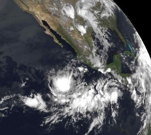
Ik blijf het altijd schitterend vinden hoe de VS zich zo sterk achten maar wel telkens met dit soort zaken krijgt te maken en er niets tegen kan doen. Dus sow slecht hebben wij het nog niet in Nederland.
Tja... de VS is dan ook tig keer zo groot als Nederland en ligt op een vrij instabiele plek vergeleken met Europa..quote:Op maandag 28 mei 2007 17:02 schreef sanni het volgende:
Ik blijf het altijd schitterend vinden hoe de VS zich zo sterk achten maar wel telkens met dit soort zaken krijgt te maken en er niets tegen kan doen. Dus sow slecht hebben wij het nog niet in Nederland.

Sea surface temperatures in the Gulf of Mexico rise due to natural summer warming. These warm surface temperatures are a contributing factor to favorable conditions that can lead to the formation of tropical storms and hurricanes in the Gulf of Mexico and off the Eastern Shore of the United States. In general, hurricanes tend to form over warm ocean water whose temperature is 82 degrees Fahreheit (approximately 27.7 degrees Celsius) or higher. These areas are depicted in yellow, orange, and red. This data was taken by the AMSR-E instrument aboard the Aqua satellite.
NASA
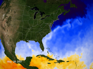
NASA
Mooi die staat nu ook in de OP. Want die misten we nog.quote:Op dinsdag 29 mei 2007 22:25 schreef aloa het volgende:
Sea surface temperatures in the Gulf of Mexico rise due to natural summer warming. These warm surface temperatures are a contributing factor to favorable conditions that can lead to the formation of tropical storms and hurricanes in the Gulf of Mexico and off the Eastern Shore of the United States. In general, hurricanes tend to form over warm ocean water whose temperature is 82 degrees Fahreheit (approximately 27.7 degrees Celsius) or higher. These areas are depicted in yellow, orange, and red. This data was taken by the AMSR-E instrument aboard the Aqua satellite.
[afbeelding]
NASA
quote:Op dinsdag 29 mei 2007 22:36 schreef Drugshond het volgende:
[..]
Mooi die staat nu ook in de OP. Want die misten we nog.
Tropische depressie 2-E (Barbara)
Op 28 mei ontwikkelde zich een lagedrukgebied boven het zuidwesten van de Golf van Tehuantepec. Aanvankelijk dreef het lagedrukgebied noordwaarts en onder gunstige omstandigheden; het warme zeewater van 30C en divergerende luchtstromingen op grote hoogte, ontwikkelde het lagedrukgebied zich op 29 mei tot tropische depressie 2-E op ongeveer 380km ten zuid-zuidoosten van Acapulco de Juarez.
Die kan weleens voor flink wat overlast gaan zorgen

[ Bericht 1% gewijzigd door #ANONIEM op 30-05-2007 06:12:21 ]
Dat kan wel eens een vervelende dame worden idd....quote:Op woensdag 30 mei 2007 06:11 schreef aloa het volgende:
[..]
Tropische depressie 2-E (Barbara)
Op 28 mei ontwikkelde zich een lagedrukgebied boven het zuidwesten van de Golf van Tehuantepec. Aanvankelijk dreef het lagedrukgebied noordwaarts en onder gunstige omstandigheden; het warme zeewater van 30C en divergerende luchtstromingen op grote hoogte, ontwikkelde het lagedrukgebied zich op 29 mei tot tropische depressie 2-E op ongeveer 380km ten zuid-zuidoosten van Acapulco de Juarez.
Die kan weleens voor flink wat overlast gaan zorgen
[afbeelding]
tvp'tje
[b]Op maandag 6 september 2010 00:28 schreef tong80 het volgende:[/b]
GVD Wat moet jij een trotse vader zijn :)
:P
GVD Wat moet jij een trotse vader zijn :)
:P
Tropical Storm Barbara Forms: An Unusually Active Start to the Eastern Pacific Hurricane Season
Forming just days after the first storm of the season, newly developed tropical storm Barbara is looming over warm ocean waters off Mexico's Pacific coast. Only twice before - in 1956 and 1984 - have there been two eastern Pacific named storms in the month of May. At 11:00 a.m. EDT (1500 UTC) on Wed., May 30, Barbara was located near 14.2 degrees north latitude and 97.3 degrees west longitude, or about 125 miles south-southwest of Puerto Angel, Mexico. Storm movement was nearly stationary, with maximum sustained winds near 35 knots (40 mph), and gusts to 45 knots (52 mph). Minimum central air pressure was estimated at 1006 millibars.
Satellite imagery shows Barbara has become a bit stronger and better organized. An upper-level trough (broad, extended area of low pressure) is developing over Mexico and the western Gulf of Mexico, while an upper-level ridge (broad, extended area of high pressure) is in place over the Pacific, west of the trough. Forecasters expect these conditions to force Barbara on a southward drift away from Mexican coastline for the next day or two. After that, the storm track becomes highly uncertain, although a continued westward path is most likely.
Atmospheric conditions remain generally favorable for additional strengthening and some forecast models bring the storm to hurricane strength by Fri., Jun. 1, as it travels over very warm ocean waters.
This visible satellite image of tropical storm Barbara was taken at 10:45 a.m. EDT (1445 UTC) on Wed., May 30, from the Geostationary Operational Environmental Satellites (GOES). The deepest clouds (bumpy white) are likely associated with thunderstorms, clustered near the storm center and west of its main circulation. Image credit: NOAA. Storm summary: Mike Bettwy, RSIS/Goddard Space Flight Center
Forming just days after the first storm of the season, newly developed tropical storm Barbara is looming over warm ocean waters off Mexico's Pacific coast. Only twice before - in 1956 and 1984 - have there been two eastern Pacific named storms in the month of May. At 11:00 a.m. EDT (1500 UTC) on Wed., May 30, Barbara was located near 14.2 degrees north latitude and 97.3 degrees west longitude, or about 125 miles south-southwest of Puerto Angel, Mexico. Storm movement was nearly stationary, with maximum sustained winds near 35 knots (40 mph), and gusts to 45 knots (52 mph). Minimum central air pressure was estimated at 1006 millibars.
Satellite imagery shows Barbara has become a bit stronger and better organized. An upper-level trough (broad, extended area of low pressure) is developing over Mexico and the western Gulf of Mexico, while an upper-level ridge (broad, extended area of high pressure) is in place over the Pacific, west of the trough. Forecasters expect these conditions to force Barbara on a southward drift away from Mexican coastline for the next day or two. After that, the storm track becomes highly uncertain, although a continued westward path is most likely.
Atmospheric conditions remain generally favorable for additional strengthening and some forecast models bring the storm to hurricane strength by Fri., Jun. 1, as it travels over very warm ocean waters.
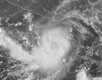
This visible satellite image of tropical storm Barbara was taken at 10:45 a.m. EDT (1445 UTC) on Wed., May 30, from the Geostationary Operational Environmental Satellites (GOES). The deepest clouds (bumpy white) are likely associated with thunderstorms, clustered near the storm center and west of its main circulation. Image credit: NOAA. Storm summary: Mike Bettwy, RSIS/Goddard Space Flight Center

Global warming: Tropical storms revealed as new factor in heat mix
Bron : Yahoo.news
Wed May 30, 1:40 PM ET
PARIS (AFP) - Hurricanes and typhoons play a significant role in distributing the ocean's heat, say US researchers, who believe they have uncovered a major, but hitherto-ignored aspect of global warming.
Driven by mighty circular winds, cyclones in the western Atlantic, western Pacific and Indian Ocean have long been known to whip up the sea and leave its local surface areas cooler than before.
In a paper appearing on Thursday in Nature, the weekly British science journal, Matthew Huber and Ryan Sriver of Purdue University in Indiana make the first stab at calculating how and where this displaced heat, driven from the surface by the cyclone, ends up.
Their computer model factors in surface sea temperatures before and after a storm's passage, as well as ocean depth and currents.
They found that a cyclone acts rather like the spinning steel blades of a food mixer as it is lowered into a bowl of batter.
The whirling winds so churn the sea that the surface heat is distributed down vertically, towards the depths of the local ocean area, but also circulating it towards the poles.
As much as a seventh of heat transported by the oceans could be linked to cyclones, the paper says.
The finding is important, because future climate change depends to a very high degree on the oceans, which cover two-thirds of the planet's surface and soak up massive amounts of heat from the atmosphere.
The role of cyclones has been overlooked until now, Huber and Sriver believe, because computer models of the world's climate systems only factor in sustained winds that last longer than five days, which would leave out most storms.
Further investigation into cyclone mixing is needed, they say.
If cyclones become more frequent as a result of higher sea temperatures, this in turn will step up the distribution of warm waters to higher latitudes, they warn.
That, in turn, would have plenty of potential for knock-on effects to the climate system.
"Cyclone-induced mixing is a fundamental physical mechanism that may act to stabilise tropical temperatures, mix the upper ocean and cause polar amplification of climate change," the researchers say.
[/q]
Bron : Yahoo.news
Wed May 30, 1:40 PM ET
PARIS (AFP) - Hurricanes and typhoons play a significant role in distributing the ocean's heat, say US researchers, who believe they have uncovered a major, but hitherto-ignored aspect of global warming.

Driven by mighty circular winds, cyclones in the western Atlantic, western Pacific and Indian Ocean have long been known to whip up the sea and leave its local surface areas cooler than before.
In a paper appearing on Thursday in Nature, the weekly British science journal, Matthew Huber and Ryan Sriver of Purdue University in Indiana make the first stab at calculating how and where this displaced heat, driven from the surface by the cyclone, ends up.
Their computer model factors in surface sea temperatures before and after a storm's passage, as well as ocean depth and currents.
They found that a cyclone acts rather like the spinning steel blades of a food mixer as it is lowered into a bowl of batter.
The whirling winds so churn the sea that the surface heat is distributed down vertically, towards the depths of the local ocean area, but also circulating it towards the poles.
As much as a seventh of heat transported by the oceans could be linked to cyclones, the paper says.
The finding is important, because future climate change depends to a very high degree on the oceans, which cover two-thirds of the planet's surface and soak up massive amounts of heat from the atmosphere.
The role of cyclones has been overlooked until now, Huber and Sriver believe, because computer models of the world's climate systems only factor in sustained winds that last longer than five days, which would leave out most storms.
Further investigation into cyclone mixing is needed, they say.
If cyclones become more frequent as a result of higher sea temperatures, this in turn will step up the distribution of warm waters to higher latitudes, they warn.
That, in turn, would have plenty of potential for knock-on effects to the climate system.
"Cyclone-induced mixing is a fundamental physical mechanism that may act to stabilise tropical temperatures, mix the upper ocean and cause polar amplification of climate change," the researchers say.
[/q]
Tropical Storm Barbara formed Wednesday off the southwestern coast of Mexico and could strengthen to a hurricane over the next several days, the U.S. National Hurricane Center said.
The storm was 118 miles south-southwest of the fishing village of Puerto Angel in southern Oaxaca state and nearly stationary with maximum sustained winds of 40 mph.
It was unclear whether Barbara would turn toward land or head out to open sea after strengthening, but people living along the western coasts of Mexico and Guatemala should monitor the storm in any case, the hurricane center said.
Barbara follows Alvin, the first tropical storm of the eastern Pacific's 2007 season. It formed Monday but was downgraded Tuesday to a tropical depression as it headed away from land. Two eastern Pacific storms in May is unprecedented — the hurricane center has named only two May storms in the past, in 1984 and 1956. (FOX)
Interessante theorie, en klinkt op zich best redelijk. Ik geloof alleen nog niet zo heel erg in modellen zolang ze nog geen flauw idee hebben van de mechanismes achter een orkaan. Zeker die 1/7de lijkt me ook onwaarschijnlijk veel, zeker als het (zoals gesuggereerd) vanaf de tropen helemaal naar de polen moet komen.quote:Op donderdag 31 mei 2007 11:36 schreef Drugshond het volgende:
Global warming: Tropical storms revealed as new factor in heat mix
Ongeveer 5,5 km/uurquote:Op donderdag 31 mei 2007 10:40 schreef Drugshond het volgende:
Er zit in iedergeval niet veel beweging in.
[afbeelding]
Dat gaat inderdaad niet snel
Hurricane Forecast for 2007: 17 Major Storms, 9 Hurricanes, 5 of Them Intense (Foxnews)
FORT COLLINS, Colo. — With the official start of the 2007 hurricane season only hours away, the bad news is that researchers backed up their prediction Thursday that nine hurricanes will form in Atlantic this season, and that five of them could be major.
The good news?
There's only a 50-50 chance that one will hit the east or gulf coasts.
That's the morning line according to researcher William Gray, who released his newest forecast showing an expectation for 17 named storms and nine hurricanes, five of them intense.
The hurricane season runs from June 1 to November 30.
Gray, based at Colorado State University, described it as a very active season. He said there was a 74 percent chance of a major hurricane making landfall somewhere on the U.S. coast.
There is a 50 percent chance of a major hurricane making landfall on the East Coast, including the Florida Peninsula, according to the new forecast; the long-term average is 31 percent.
The chance of a major hurricane hitting the Gulf Coast between the Florida Panhandle and Brownsville, Texas, is 49 percent; the long-term average is 30 percent. There is also an above-average chance of a major hurricane making landfall in the Caribbean, according to the forecast.
Thursday's forecast was largely unchanged from Gray's last forecast, released in early April.
"We expect an above-average hurricane season," said Phil Klotzbach, a member of Gray's team and lead author of the forecast.
The Atlantic hurricane season averages 9.6 named storms, 5.9 hurricanes and 2.3 intense hurricanes per year.
There were 10 named Atlantic storms last year and five hurricanes, two of them major. None of the hurricanes hit the U.S. Atlantic coast.
The devastating 2005 season set a record with 28 named storms, 15 of them hurricanes. Four hurricanes hit the U.S. coast, the worst among them , which devastated parts of the Gulf Coast.

Tropical Storm Barbara
Tropical Storm Barbara, the second named storm of the 2007 Pacific hurricane season, was swirling off the coast of Mexico on May 29, 2007, when it was observed by NASA’s QuikSCAT satellite at 5:25 p.m. local time (00:25 UTC on May 30, 2007). According to Mexico’s National Meteorological Service (Spanish language site), Barbara had sustained winds that peaked around 100 kilometers/hour (55 mph) on May 29, but had eased off since then. The U.S. National Hurricane Center predicted (as of May 31) that the storm most likely would not become a hurricane, but could bring heavy rain to the Mexican and Guatemalan Pacific coastal regions.
This data visualization of QuikSCAT’s observations shows Tropical Storm Barbara and its spiral pattern of winds. The image depicts wind speed in color and wind direction with small barbs. White barbs point to areas of heavy rain. The storm does not have a clear, rain-free center or a tight spiral shape as would be expected of a larger and more powerful storm.
QuikSCAT employs a scatterometer, which sends pulses of microwave energy through the atmosphere to the ocean surface, and measures the energy that bounces back from the wind-roughened surface. The energy of the microwave pulses changes depending on wind speed and direction, giving scientists a way to monitor wind around the world. This technique does not work over land, but allows measurements in storms over oceans.
The Pacific hurricane season begins on May 15 each year, and in 2007, the season had already registered two named storms by the end of the month, Alvin and Barbara. The U.S. National Hurricane Center has only twice before recorded more than one named storm in the Pacific in May (in 1984 and 1956). Hurricane forecasters have been predicting a busy season for hurricanes in both the Pacific and Atlantic basins in 2007, and the early surge of storms is consistent with this forecast.
A TROPICAL STORM WARNING HAS BEEN ISSUED
FOR THE WEST COAST OF FLORIDA FROM BONITA BEACH NORTHWARD TO KEATON
BEACH...AND A TROPICAL STORM WATCH HAS BEEN ISSUED FROM NORTH OF
KEATON BEACH TO ST. MARKS.
FOR THE WEST COAST OF FLORIDA FROM BONITA BEACH NORTHWARD TO KEATON
BEACH...AND A TROPICAL STORM WATCH HAS BEEN ISSUED FROM NORTH OF
KEATON BEACH TO ST. MARKS.
/ ¦ ¦ / ¦ ¦
welk systeem zorgt hiervoor, kan zo snel even niets vindenquote:Op vrijdag 1 juni 2007 22:41 schreef highway101 het volgende:
A TROPICAL STORM WARNING HAS BEEN ISSUED
FOR THE WEST COAST OF FLORIDA FROM BONITA BEACH NORTHWARD TO KEATON
BEACH...AND A TROPICAL STORM WATCH HAS BEEN ISSUED FROM NORTH OF
KEATON BEACH TO ST. MARKS.
[b]Op maandag 6 september 2010 00:28 schreef tong80 het volgende:[/b]
GVD Wat moet jij een trotse vader zijn :)
:P
GVD Wat moet jij een trotse vader zijn :)
:P


Wat een welopgevoede jongen! Netjes jezelf op 1 juni aanmelden, en nog keurig midden op de dag. Goed hoor.
Wel grappig dat de eerste twee stormen van het jaar op plekken lijken te ontstaan die volgens de NASA nog niet of nauwelijks warm genoeg zijn. En als ik zie hoe Barry aan het doorscheuren is, zal het met de shear toch ook niet meevallen.
Wel grappig dat de eerste twee stormen van het jaar op plekken lijken te ontstaan die volgens de NASA nog niet of nauwelijks warm genoeg zijn. En als ik zie hoe Barry aan het doorscheuren is, zal het met de shear toch ook niet meevallen.
Florida is er in elk geval 'blij' mee... ivm de aanhoudende droogte..
===============================================
Tropical Storm Barry Targets Northern Florida (fox)
MIAMI — Tropical Storm Barry brought heavy rain to a parched Florida early Saturday, along with strong winds and heavy surf along the state's Gulf coast.
Rain was falling throughout the state, where droughts conditions have left Lake Okeechobee at its lowest recorded level and allowed an isolated brush fire on the Georgia-Florida border to burn for weeks. The storm was expected to drop 3 to 6 inches of rain on parts of the state Saturday. Isolated areas could get up to 10 inches of rain.
"It'll help a little bit, but everyone is so far below rainfall that we're still going to be under drought conditions," said Kim Brabander, a meteorologist with the National Weather Service. "To really alleviate the drought conditions we're going to need anywhere from 30 to 40 inches of rain."
Click Here for the Latest Information From the National Hurricane Center
At 8 a.m. EDT, Barry was centered in the Gulf of Mexico about 85 miles southwest of Tampa. It had sustained winds of about 50 mph near the center with higher gusts and was moving north-northeast at about 20 mph. Wind gusts of up to 47 mph were reported on the state's southern and eastern coasts Saturday morning.
The storm was not expected to strengthen into a hurricane, said Dave Roberts, a hurricane specialist at the National Hurricane Center.
A tropical storm warning was issued from Bonita Beach on Florida's southwest coast northward to Keaton Beach, near the state's Big Bend area, as Barry was expected to make landfall on the Peninsula's central or northern Gulf coast by Saturday evening. A tropical storm watch was issued for the area between Keaton Beach west to St. Marks, south of Tallahassee.
The National Weather Service also issued a tornado watch for 26 Florida counties as Barry inched closer.
The storm's winds were forecast to weaken as it moves north, but Barry was expected to bring rain across the Atlantic seaboard, reaching North Carolina by late Sunday and New England by late Monday.
The storm developed Friday, the first official day of a hurricane season that forecasters have said they expect to be busier than normal. The National Weather Service said it expects 13 to 17 tropical storms, with seven to 10 becoming hurricanes and three to five in the strong category.
"There is no correlation at all between activity in the early part of the season and later parts," said Lixion Avila, a hurricane specialist at the center.
The hurricane center said Barry threatened to bring dangerous battering waves, coastal flooding up to 5 feet. Tropical storm force winds extended outward up to 90 miles, forecasters said.
Barry formed more than three weeks after the first named storm of the year — Subtropical Storm Andrea — developed off Florida's eastern coast. Andrea skirted the southern Atlantic coast but caused minimal damage.
...BARRY WEAKENED AS IT MOVED INLAND ACROSS TAMPA BAY...
AT 11 AM EDT...1500 UTC...THE TROPICAL STORM WARNING AND THE
TROPICAL STORM WATCH FOR FLORIDA HAS BEEN DISCONTINUED.
AT 11 AM EDT...1500 UTC...THE TROPICAL STORM WARNING AND THE
TROPICAL STORM WATCH FOR FLORIDA HAS BEEN DISCONTINUED.
/ ¦ ¦ / ¦ ¦
Ah, dat ligt dus niet aan mijn pcquote:Op zondag 3 juni 2007 09:26 schreef Drugshond het volgende:
Leuk al die stormpjes, alleen de laadtijd om dit topic te bekijken is iets minder.
Wel balen inderdaad
Dat vroeg ik me vannacht ook al af inderdaad...quote:Op zondag 3 juni 2007 12:11 schreef highway101 het volgende:
Oman wordt volgens mij niet al te vaak getroffen door orkanen...
Klopt, Oman wordt niet zo vaak getroffen, kortom, gaat weer wat schade komen
<a href="https://www.youtube.com/channel/UCPueUwKfPaGH7v48LZlltkg" rel="nofollow" target="_blank">WSDokkum Youtube</a>
Ik denk dat deze storm, zeker door de verwachte koers, een igen topic verdiend.
Officiele forecast:
REMARKS:
040900Z POSITION NEAR 19.4N 64.5E.
TROPICAL CYCLONE (TC) 02A (GONU), LOCATED APPROXIMATELY 440 NM
SOUTHEAST OF MUSCAT, OMAN, HAS TRACKED NORTHWESTWARD AT 09 KNOTS
OVER THE PAST 06 HOURS. TRACK REASONING REMAINS THE SAME AS THE
PREVIOUS FORECAST, ALTHOUGH UNCERTAINTY IN THE LATER TAUS REMAINS
AS THE DYNAMIC AIDS CONTINUE TO DIVERGE AFTER TAU 48. TC 02A
CONTINUES TO TRACK NORTHWESTWARD ALONG THE SOUTHWESTERN PERIPHERY
OF A MID-LEVEL STEERING RIDGE ANCHORED OVER CENTRAL INDIA. THE
SYSTEM WILL ENCOUNTER A SECOND RIDGE ANCHORED OVER THE ARABIAN
PENINSULA AS IT CONTINUES TO TRACK NORTHWESTWARD. HOWEVER, A
SERIES OF MID-LATITUDE TROUGHS APPROACHING FROM THE NORTH AND
WEST OF THE THE RIDGE AXIS ARE EXPECTED TO MAINTAIN A WEAKNESS
BETWEEN THE RIDGE CENTERS OVER INDIA AND SAUDI ARABIA, ALLOWING
TC 02A TO TRACK TOWARD THE NORTHEAST COAST OF OMAN THROUGH THE
FORECAST PERIOD. THE NOGAPS AND GFDN NUMERICAL MODELS DEPICT A
STRONG WEAKNESS IN THE RIDGES CAUSED BY ONE OF THE AFOREMENTIONED
MID-LATITUDE TROUGHS BETWEEN TAU 48 AND 72, WHICH WOULD INDICATE
A RECURVATURE SCENARIO THAT WOULD TAKE THE SYSTEM INTO THE GULF
OF OMAN TOWARD THE COAST OF IRAN IN THE EXTENDED PERIOD. EGRR,
GFS, AND AFWA MM5 DEPICT A WEAKER TROUGH, LESS OF A WEAKNESS
IN THE RIDGING AND THEREFORE A MORE WESTWARD TRACK. THE EXACT
TRACK OF THE SYSTEM WILL DEPEND HIGHLY ON THE LOCATION AND MAGNITUDE
OF THIS RIDGE WEAKNESS INDUCED BY THE DEVELOPING MID-LATITUDE
TROUGHS. THIS FORECAST IS BASED ON A CONSENSUS OF THE AVAILABLE
MODELS WITH LESS EMPHASIS TOWARD NOGAPS AND GFDN AT TAU 72 SINCE
THIS IS THE FIRST MODEL RUN THAT IS DEPICTING THE RECURVE SCENARIO.
THE STORM CONTINUES TO REMAIN UNDER AN EXTENSIVE UPPER LEVEL RIDGE
AXIS, WITH LOW VERTICAL WIND SHEAR AND EXCELLENT WESTWARD AND
POLEWARD OUTFLOW. THESE FAVORABLE UPPER LEVEL CONDITIONS HAVE LED
TO RAPID INTENSIFICATION OVER THE PAST 18 HOURS. THE SYSTEM IS
EXPECTED TO WEAKEN SLIGHTLY OVER THE NEXT 24 HOURS AS IT MOVES
OVER LOWER OCEAN HEAT CONTENT, BUT MAINTAINS FAVORABLE UPPER LEVEL
OUTFLOW. TC 02A IS FORECAST TO WEAKEN MORE QUICKLY AFTER TAU 24
DUE TO THE ENTRAINMENT OF DRY AIR FROM THE ARABIAN PENINSULA AND
THEN LAND EFFECTS AFTER LANDFALL NEAR TAU 48. MAXIMUM SIGNIFICANT
WAVE HEIGHT AT 040600Z IS 40 FEET. NEXT WARNINGS AT 041500Z, 042100Z,
050300Z AND 050900Z.//
https://metocph.nmci.navy.mil/jtwc/warnings/io0207web.txt
Deze cycloon (zoals deze genoemd worden in dit deel van de wereld), volgt een aparte route. Normaal ontstaan er al vrij weinig stormen rond de westkust van India. En als deze er al zijn, koersen ze meestal naar het westen of zuidwesten. Of deze verdwijnen al op de oceaan, of ze komen richting Madagaskar / mozambique uit. Meestal sterk verzwakt.
Nu gaat het pad naar het noord westen, in de richting van Oman.
Oman is een woestijnland, waar het aan de kust vochtig heet is. 45 graden komt regelmatig voor. Het binnenland is heet en drooog.
Een belangrijke (belangrijkste) bron van inkomsten is, het is natuurlijk het midden oosten) olie.
Mocht deze storm Oman hard raken, zou dat ook een invloed kunen heben op de olieprijs en daaraan gekoppeld ook de gas en electra prijs.
We zullen dat dan ook vrijwel direct merken aan de pomp.
hierna KAN Gonu verzwakken, maar komt dan misschien weer boven de (warme) Perzische golf uit. daar kan dus ook weer schade ontstaan.
Al met al moeten we de ontwikkelingen goed volgen. Het is een aparte storm met misschien wel grote invloeden.
Ik HAAT mijn toetsenbord.
Central Command van de Amerikanen over álles wat er zo'n beetje in die buurt gebeurt (Irak, Afghanistan, Somalië, Iran etc) zit toch ook daar?
LastFM
03/06 Maccabees - 10/06 Gaslight Anthem - 18/06 Oi Vai Voi - 20/06 Green Beats - 24/06 Ghinzu - 18/07 Extrema Outdoor
03/06 Maccabees - 10/06 Gaslight Anthem - 18/06 Oi Vai Voi - 20/06 Green Beats - 24/06 Ghinzu - 18/07 Extrema Outdoor
Wow .. Tropical Cyclone Gonu is nu Catogorie 5 !!
Windsnelheden : 260km per uur !
Uitschieters : 313km per uur !

Windsnelheden : 260km per uur !
Uitschieters : 313km per uur !
2007 = Supper orkaan zeisoen !
Cool zou je daar maar in zitten
<a href="https://www.youtube.com/channel/UCPueUwKfPaGH7v48LZlltkg" rel="nofollow" target="_blank">WSDokkum Youtube</a>
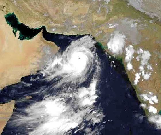
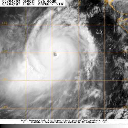
Oman on alert for cyclone - official news agency
DUBAI, June 4 (Reuters) - Gulf oil producer Oman ahead of the expected landfall of a cyclone has called a state of emergency for its army and police and called for people to leave dangerous areas, naming two islands, the official ONA news agency said on Monday.
Oman's weather service warned that the cyclone will have winds of 185-205 km (114-128 miles) per hour cause "very high waves".
Oman is an independent oil exporter pumping around 715,000 barrels per day of crude oil and condensates.
vriend van mij werkt en woont in die regio, volgens mij zijn ze dat niet erg gewend daar Als hij klaagt over orkanen zit hij altijd in Taiwanquote:Op maandag 4 juni 2007 18:52 schreef aloa het volgende:
Dat gaat een flinke zandstorm worden
[afbeelding]
[b]Op maandag 6 september 2010 00:28 schreef tong80 het volgende:[/b]
GVD Wat moet jij een trotse vader zijn :)
:P
GVD Wat moet jij een trotse vader zijn :)
:P
Tropical Cyclone Gonu in Arabian Sea
A powerful tropical cyclone is churning through the Arabian Sea toward Oman and Iran. Tropical Cyclone Gonu, with maximum sustained winds of 160 mph, is the equivalent of a category five hurricane.
Gonu is moving off toward the west-northwest and on its current course it would come very close to the northeast tip of Oman late Tuesday afternoon and evening (U.S. time). Gonu is forecast to weaken some, but would still be the equivalent of a category three hurricane as it passes close to Oman.
The current forecast keeps the eye of Gonu over water as it brushes by Oman and then turns the system toward southern Iran. Should the center remain over water it could hit Iran with maximum winds close to 75 mph.
While tropical storms have hit Oman in the past, they are rare, and there is no record of a hurricane-strength cyclone striking the country. The last tropical storm to smack the nation was in May 2002.
Meanwhile, in the Atlantic and eastern Pacific Basins, there are no imminent threats of tropical cyclone development.
The remnants of Tropical Storm Barry are belting northern New England and Upstate New York with heavy rain and gusty winds this afternoon. While some localized flooding will occur, no major damage is anticipated. New York City's Central Park picked up 3.91 inches of rain due to the remnants of Barry.
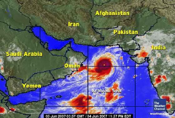
Zeer interessant artikel:
http://dutch.wunderground.com/blog/JeffMasters/comment.html?entrynum=690&tstamp=200706
Dit kan dus goed fout gaan.
mensen, ga snel tanken!
http://dutch.wunderground.com/blog/JeffMasters/comment.html?entrynum=690&tstamp=200706
Dit kan dus goed fout gaan.
mensen, ga snel tanken!
Ik HAAT mijn toetsenbord.
De verzakking van Gonu is vrijwel uitgebleven. Climatologisch niet te verklaren, immers is het zeewater momenteel koeler!
Oman heeft nu regen. De zwaarste klappen zijn voor vannacht/ morgenochtend. Daarna is Iran absoluut aan de beurt. Oman cat 3, Iran cat 2...
Maar een groot probleem zal de neerslag zijn.
Oman heeft nu regen. De zwaarste klappen zijn voor vannacht/ morgenochtend. Daarna is Iran absoluut aan de beurt. Oman cat 3, Iran cat 2...
Maar een groot probleem zal de neerslag zijn.
Ik HAAT mijn toetsenbord.
Dat is onzin, want ik woon er. Voorzover ik weet is er alleen wat motregen geweest in eht westen. Maar de rest is wel waar! Mensen zijn al aan het evacueren in Muscat en de scholen zijn gesloten. Het verhaal gaat dat het binnen 4 uur gaat beginnen!quote:Op dinsdag 5 juni 2007 11:35 schreef tweakdsl het volgende:
De verzakking van Gonu is vrijwel uitgebleven. Climatologisch niet te verklaren, immers is het zeewater momenteel koeler!
Oman heeft nu regen. De zwaarste klappen zijn voor vannacht/ morgenochtend. Daarna is Iran absoluut aan de beurt. Oman cat 3, Iran cat 2...
Maar een groot probleem zal de neerslag zijn.
Cool story, Hansel.
Wat gebeurt er?
Er is pasgeleden een Orkaan [of cycloon] gevormd in de Golf van Oman, Cycloon Gonu. Er is veel heisa onstaan en er word druk geevacueerd. De scholen zijn al geslotenen veel mensen die aan de rand van de stad wonen zijn gestopt met werken en proberen nu naar huis te gaan.
Hoe ziet hij eruit?
Nou zo:
Hij draait met zo'n snelheid van 155 Mijlen per uur en beweegt zich met ongeveer 7-10 mph voort.
Wanneer raakt hij Muscat/Oman?
Het gerucht gaat nu dat hij binnen vier uur Muscat zal raken. Officieel wordt het morgenochtend tot en met donderdag of vrijdag.
Wat merk je er zelf van?
ik doe examens en die zijn niet [ ] afgelast maar als je door het weer niet kan komen dan hoeft het niet. Verder zijn de scholen al gesloten [behalve voor mensen die examens doen dan] en gaan er een hoop mensen al naar huis. Ik heb wat fotos genomen van het verkeer dat ongeveer vast staat:
Dat is dus de snelweg die naar de buitenwijken gaat.
De brief van school:
En de wolken [wat hier niet zo veel voorkomt]
En de zee staat al aardig hoog, maar er zijn nog niet zoveel golven.
Waarom doe je dit?
Het leek me leuk/interessant om mensen er actueel van op de hoogte te houden!
Ik geloof je niet, ik wil bewijs!
Het staat al in het nieuws maar hier nog meer plaatjes van Gonu:
http://uploader.ws/upload/200706/image005.jpg
http://uploader.ws/upload/200706/image006.jpg
http://uploader.ws/upload/200706/image002.gif
Nieuwslinks
Link 1
Link 2
Link 3
En ik wacht af wat er gebeuren zal
[ Bericht 11% gewijzigd door wikwakka2 op 05-06-2007 12:17:32 (Meer pics) ]
Er is pasgeleden een Orkaan [of cycloon] gevormd in de Golf van Oman, Cycloon Gonu. Er is veel heisa onstaan en er word druk geevacueerd. De scholen zijn al geslotenen veel mensen die aan de rand van de stad wonen zijn gestopt met werken en proberen nu naar huis te gaan.
Hoe ziet hij eruit?
Nou zo:

Hij draait met zo'n snelheid van 155 Mijlen per uur en beweegt zich met ongeveer 7-10 mph voort.
Wanneer raakt hij Muscat/Oman?
Het gerucht gaat nu dat hij binnen vier uur Muscat zal raken. Officieel wordt het morgenochtend tot en met donderdag of vrijdag.
Wat merk je er zelf van?
ik doe examens en die zijn niet [ ] afgelast maar als je door het weer niet kan komen dan hoeft het niet. Verder zijn de scholen al gesloten [behalve voor mensen die examens doen dan] en gaan er een hoop mensen al naar huis. Ik heb wat fotos genomen van het verkeer dat ongeveer vast staat:

Dat is dus de snelweg die naar de buitenwijken gaat.
De brief van school:

En de wolken [wat hier niet zo veel voorkomt]

En de zee staat al aardig hoog, maar er zijn nog niet zoveel golven.

Waarom doe je dit?
Het leek me leuk/interessant om mensen er actueel van op de hoogte te houden!
Ik geloof je niet, ik wil bewijs!
Het staat al in het nieuws maar hier nog meer plaatjes van Gonu:
http://uploader.ws/upload/200706/image005.jpg
http://uploader.ws/upload/200706/image006.jpg
http://uploader.ws/upload/200706/image002.gif
Nieuwslinks
Link 1
Link 2
Link 3
En ik wacht af wat er gebeuren zal
[ Bericht 11% gewijzigd door wikwakka2 op 05-06-2007 12:17:32 (Meer pics) ]
Cool story, Hansel.
Dat heb ik nog niet eerder gezien, een orkaan in dat gebied. En het is een zware jongen ook nog! Ben benieuwd wel gebied getroffen gaat worden en hoe zwaar.
er wordt geëvacueerd, maar de examens gaan wel door?
Wie verzint dat?
Wie verzint dat?
If you wish to be a success in the world, promise everything, deliver nothing.
Nothing is more difficult, and therefore more precious, than to be able to decide.
Victory belongs to the most persevering
Nothing is more difficult, and therefore more precious, than to be able to decide.
Victory belongs to the most persevering
Idd lichte regen en motregen uit de buitenste banden bewolking.quote:Op dinsdag 5 juni 2007 11:46 schreef wikwakka2 het volgende:
[..]
Dat is onzin, want ik woon er. Voorzover ik weet is er alleen wat motregen geweest in eht westen. Maar de rest is wel waar! Mensen zijn al aan het evacueren in Muscat en de scholen zijn gesloten. Het verhaal gaat dat het binnen 4 uur gaat beginnen!
Maar er komt veel en veel meer. Ik wens je succes! Woon je in Muscat?
Ik HAAT mijn toetsenbord.
Nieuwsbronnen staan er nu ook bij.
En ja de examens gaan gewoon door Dat is nou de Britse mentaliteit.
MASD, werkt uploader.ws niet bij jou dan? Hier werkt ie gewoon.
En ja de examens gaan gewoon door Dat is nou de Britse mentaliteit.
MASD, werkt uploader.ws niet bij jou dan? Hier werkt ie gewoon.
Cool story, Hansel.
delete je cookies en je zult zien dat het niet aan mij ligtquote:Op dinsdag 5 juni 2007 12:19 schreef wikwakka2 het volgende:
Nieuwsbronnen staan er nu ook bij.
En ja de examens gaan gewoon door Dat is nou de Britse mentaliteit.
MASD, werkt uploader.ws niet bij jou dan? Hier werkt ie gewoon.
Long live music.
Kan deze stomr dan ook zoveel water opstuwen dat de opsgespoten eilandjes bij saudie arabie dan overstromen?
Volgens mij bedoel je bij de Emiraten?
Dubai?
Dat denk ik niet. Het gevaar zit suidelijker, buiten de Perzische golf.
Dubai?
Dat denk ik niet. Het gevaar zit suidelijker, buiten de Perzische golf.
Ik HAAT mijn toetsenbord.

Fuck, die crappy huizen die je ziet op doe Google Maps gaan echt helemaal naar de klote
LastFM
03/06 Maccabees - 10/06 Gaslight Anthem - 18/06 Oi Vai Voi - 20/06 Green Beats - 24/06 Ghinzu - 18/07 Extrema Outdoor
03/06 Maccabees - 10/06 Gaslight Anthem - 18/06 Oi Vai Voi - 20/06 Green Beats - 24/06 Ghinzu - 18/07 Extrema Outdoor
In de pacific zijn volgens mij al wat cat. 5 typhoons geweest.quote:Op dinsdag 5 juni 2007 14:07 schreef Catogorie5 het volgende:
Is dit trouwens de 1st Catogorie 5 was het jaar 2007 ?
/ ¦ ¦ / ¦ ¦
Ja die bedoel ik idd in dubaiquote:Op dinsdag 5 juni 2007 12:42 schreef tweakdsl het volgende:
Volgens mij bedoel je bij de Emiraten?
Dubai?
Dat denk ik niet. Het gevaar zit suidelijker, buiten de Perzische golf.
[b]Update[/bold]
We worden geevacueerd Aangezien onze straat tussen twee bergen in ligt moeten we naar een huis op de berg. Zo ook minstens drie andere straten in onze wijk.
Ze verwachten dat het water in onze huizen komt te staan dus alle belangrijke dingen moeten naar boven worden gebracht. Wat een gedoe.
We worden geevacueerd Aangezien onze straat tussen twee bergen in ligt moeten we naar een huis op de berg. Zo ook minstens drie andere straten in onze wijk.
Ze verwachten dat het water in onze huizen komt te staan dus alle belangrijke dingen moeten naar boven worden gebracht. Wat een gedoe.
Cool story, Hansel.
Foto van 18.00 uurquote:Tropical Cyclone Gonu is weakening as it churns toward the Gulf of Oman from the Arabian Sea. As of 8 a.m. EDT, Gonu's maximum sustained winds were down to 120 mph (from 160 mph yesterday).
Gonu is expected to continue weakening as it brushes by the northeast tip of Oman (Ra's al Hadd) over the next several hours. Weakening influences include slightly cooler ocean water, dry air from the Arabian Peninsula and Iran, interaction with land, and increasing vertical wind shear.
The cyclone is forecast to turn northward in the Gulf of Oman and strike the southern coast of Iran (Makran Coast) late tomorrow U. S. time. By the time it makes landfall, winds are expected to be down to 80 mph (a category one equivalent). Flash flooding will be a major threat.
Since 1945, there is no record of any type of tropical cyclone striking Iran.
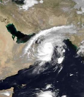
Is inmiddels gebeurd.quote:Op dinsdag 5 juni 2007 15:36 schreef Party_P het volgende:
Kan dit topic niet gemerged worden met deze: Cyclone Gonu- cat 4/5 naar Oman
Meer info ook --> Hurricane Season 2007- there is BARRY

Tropical Cyclone Gonu
A storm with near-perfect symmetry and a well-defined eye hovering over the warm waters of the Caribbean or in the South Pacific is not unusual, but Tropical Cyclone Gonu showed up in a rather different place: the Arabian Sea. Though rare, cyclones like Gonu are not unheard of in the northern Indian Ocean basin. Most cyclones that form in the region form over the Bay of Bengal, east of India. Those that take shape over the Arabian Sea, west of the Indian peninsula, tend to be small and fizzle out before coming ashore. Cyclone Gonu was a rare exception. According to storm statistics maintained on Unisys Weather, the last storm of this size to form over the Arabian Sea was Cyclone 01A, which tracked northwest along the coast of India between May 21 and May 28, 2001. Unlike Gonu’s forecasted track, Cyclone 01A’s path never brought it ashore.
At 9:35 a.m. local time (06:35 UTC) on June 5, 2007, when the Moderate Resolution Imaging Spectroradiometer (MODIS) on NASA’s Terra satellite captured this image, Tropical Cyclone Gonu was approaching the northeastern shore of Oman. At this time, the powerful storm had reached a dangerous Category 4 status. Sustained winds were measured at 250 kilometers per hour (155 miles per hour) according to the University of Hawaii’s Tropical Storm Information Center, at the time of this MODIS image. The storm has the hallmark tightly wound arms that spiral around a well-defined, circular eye. The eye is surrounded by a wall of towering clouds that cast shadows on the surrounding clouds. Called hot towers, these clouds are a sign of the powerful uplift that feeds the storm. The symmetrical spirals, distinct eye, and towering clouds are all features regularly seen in satellite images of other particularly powerful cyclones, which are also known as typhoons or hurricanes when they form in other parts of the world.
The forecast as of June 5 called for the storm to graze Oman’s shore, but with the center of the storm staying offshore in the Gulf of Oman. The storm’s first landfall was predicted to be in southern Iran. The cooler water along the Oman coast was expected to rob the storm of some of its intensity, and it was predicted to strike the Iranian coast at around Category 1 strength. If, however, the forecast track is not quite right and the storm stays farther from shore over shallower and much warmer waters in the Gulf of Oman, it could make landfall while still packing Category 3 winds. In either case, communities along the Gulf of Oman are poorly prepared for hurricanes, given their rarity, and severe damage to cities and oil platforms is possible due to winds and storm surge.

Dat is al aangekomen!
Er zijn alleen vrij weinig nieuwsberichten. Vanaf nu tot morgen vroeg is Iran aan de beurt.
Er zijn alleen vrij weinig nieuwsberichten. Vanaf nu tot morgen vroeg is Iran aan de beurt.
Ik HAAT mijn toetsenbord.
Sorry voor mijn late reply internet werd vantevoren door het bedrijf al uitgezet, maar uiteindelijk bleek dial up toch te werken.. De storm kwam inderdaad gister nacht om 1 uur 'savonds aan. Wij zaten eerst bij vrienden thuis maar zijn toen er niks gebeurde zijn we maar (als enige in onze straat) naar huis gegaan. Om 1 uur kwam dan eindelijk de storm en het heeft nogal hard gewaaid en geregend. Er zijn vannacht en vanochtend gigantsich veel bomen omgewaaid. Ook kan ik mijn wijk niet meer uit want het water staat op bepaalde plaatsen tot 3 meter hoog! Mijn van vandaag zijn net door de school gecancelled, maar die van morgen moet ik nu vrijdag doen. Een hoop pics komen eraan als ADSL het weer doet. We zitten waarschijnlijk nog voor een dag of 2 vast.
Cool story, Hansel.

Kan ik daaruit concluderen dat het allemaal wel meevalt?quote:Op woensdag 6 juni 2007 17:40 schreef tweakdsl het volgende:
Dat is al aangekomen!
Er zijn alleen vrij weinig nieuwsberichten. Vanaf nu tot morgen vroeg is Iran aan de beurt.
Din jävla kuk!

Oh. Helder.quote:Op woensdag 6 juni 2007 17:57 schreef wikwakka2 het volgende:
Sorry voor mijn late reply internet werd vantevoren door het bedrijf al uitgezet, maar uiteindelijk bleek dial up toch te werken.. De storm kwam inderdaad gister nacht om 1 uur 'savonds aan. Wij zaten eerst bij vrienden thuis maar zijn toen er niks gebeurde zijn we maar (als enige in onze straat) naar huis gegaan. Om 1 uur kwam dan eindelijk de storm en het heeft nogal hard gewaaid en geregend. Er zijn vannacht en vanochtend gigantsich veel bomen omgewaaid. Ook kan ik mijn wijk niet meer uit want het water staat op bepaalde plaatsen tot 3 meter hoog! Mijn van vandaag zijn net door de school gecancelled, maar die van morgen moet ik nu vrijdag doen. Een hoop pics komen eraan als ADSL het weer doet. We zitten waarschijnlijk nog voor een dag of 2 vast.
Din jävla kuk!
http://news.bbc.co.uk/2/hi/middle_east/6722749.stm :
quote:Cyclone hits Gulf state of Oman
A powerful cyclone is passing near the Gulf state of Oman, bringing heavy rains to the capital, Muscat.
Tropical Cyclone Gonu is continuing north-west towards Iran but wind speeds have dropped to about 100mph (175 km/h). Thousands of residents were evacuated from Oman's coast and the offshore island of Masirah. Hundreds have also been evacuated from the Iranian coast. The storm is the most powerful in the region for 60 years.
The US military predicted that Gonu would become a "very weak" tropical cyclone over the next 48-72 hours. But there were predictions that heavy rains could cause flash flooding by the time Gonu reached the south coast of Iran.
High waves
In Oman, people were told to stay indoors, while schools and public buildings were emptied to make room for the evacuees. BBC Gulf correspondent Julia Wheeler says Gonu is bringing both strong winds and waves of up to 12m high (36ft). Low-lying areas have been evacuated. In the island of Masirah, 230km off the coast (140 miles), 7,000 people have left their homes.
In the coastal capital of Muscat, people have been advised to stay indoors and to switch off their power. Schools have been designated as emergency shelters and the international airport is closed. The most powerful part of the storm was expected to hit Oman on Thursday, before moving north across the Gulf to Iran. Hundreds of people living in low-lying areas of Iran have been moved to higher ground amid warnings that the waning storm could bring heavy rain, flash floods and high waves.
An emergency official quoted by the AFP news agency said all people living close to the sea between the towns of Chahbahar and Konarak - a 25km (15 miles) stretch of coast - had been evacuated. Reports say Cyclone Gonu is the strongest to hit the Arabian Peninsula since records started in 1945. While crossing the Indian Ocean on Monday it reached the equivalent of a Category Five hurricane - the highest category available.
Oman getroffen door orkaan Gonu
De orkaan Gonu is woensdag als een zwakke orkaan langs Oman getrokken en onderweg naar Iran. Gonu was de afgelopen dagen tijdelijk een orkaan van de allerhoogste categorie (cat 5) en de zwaarste orkaan sinds 1977 die de kust van Oman bereikte.
Oman kreeg woensdag te maken met forse winstoten tot 150 kilometer per uur. Ook viel er veel neerslag. De golfhoogte liep op tot 6 meter. De autoriteiten evacueerden 11000 werknemers uit het kustgebied. De elektriciteit in de stad Muscat viel uit en al het contact was verbroken. Veel straten in de stad liepen onder en de toegangswegen waren onbegaanbaar.
In de loop van donderdag wordt Iran bereikt. Het is de eerste keer sinds 1945 dat een orkaan in Iran aan land komt. In dat jaar begonnen de officiële statistieken. Waarschijnlijk is het systeem dan alweer alweer afgezwakt tot een tropische storm of een tropische depressie.
[ Bericht 4% gewijzigd door #ANONIEM op 06-06-2007 21:22:38 ]
De orkaan Gonu is woensdag als een zwakke orkaan langs Oman getrokken en onderweg naar Iran. Gonu was de afgelopen dagen tijdelijk een orkaan van de allerhoogste categorie (cat 5) en de zwaarste orkaan sinds 1977 die de kust van Oman bereikte.
Oman kreeg woensdag te maken met forse winstoten tot 150 kilometer per uur. Ook viel er veel neerslag. De golfhoogte liep op tot 6 meter. De autoriteiten evacueerden 11000 werknemers uit het kustgebied. De elektriciteit in de stad Muscat viel uit en al het contact was verbroken. Veel straten in de stad liepen onder en de toegangswegen waren onbegaanbaar.
In de loop van donderdag wordt Iran bereikt. Het is de eerste keer sinds 1945 dat een orkaan in Iran aan land komt. In dat jaar begonnen de officiële statistieken. Waarschijnlijk is het systeem dan alweer alweer afgezwakt tot een tropische storm of een tropische depressie.
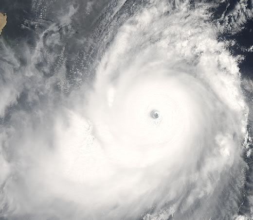
[ Bericht 4% gewijzigd door #ANONIEM op 06-06-2007 21:22:38 ]
Doden in Oman door Cycloon (nieuws.nl)
Een cycloon die woensdag het kustgebied van Oman trof, heeft aan zeker twaalf mensen het leven gekost, onder wie enkele reddingswerkers. Meer dan twintigduizend mensen waren uit voorzorg geëvacueerd in verband met de cycloon, Gonu genaamd, en de olie-export kwam vrijwel stil te liggen. Op sommige plaatsen deden zich overstromingen voor, maar de schade bleef over het algemeen beperkt.
Cyclonen komen zelden voor in het Midden-Oosten. Ook in Iran werden in het kustgebied langs de Golf van Oman voorzorgsmaatregelen genomen, maar toen de storm daar donderdag aankwam had hij niet meer de kracht van een cycloon.
Dodental is gestegen naar 15
quote:Dodental Gonu opgelopen tot 15
De tropische depressie Gonu heeft in Oman en Iran aan vijftien mensen het leven gekost. Het systeem lag donderdagavond voor de kust van Iran.
In Oman werd forse schade aangericht. Een deel van de hoofdstad Masqat staat onder water en auto’s werden door wind en water omgekeerd. Tienduizenden kustbewoners werden geëvacueerd. Hetzelfde gebeurde in Iran waar op voorhand al 3 mensen om het leven kwamen. In het zuidwesten van Pakistan vluchtte ook honderden mensen naar hogere gronden.
Plaatjes zeggen meer dan woorden en ze komen er morgenochtend aan! Heb er aardig wat.
Cool story, Hansel.
Volgens mij is het al een stuk meer dan dat. Alhoewel er wel gelukkig snel werd gehandeld. De belangrijkste straten zijn al schoongeveegd en electriciteit doet het weer.quote:Op donderdag 7 juni 2007 22:05 schreef Catogorie5 het volgende:
dodental is gestegen nu naar 23 !
Maar zoals beloofd hier de plaatjes!
[Heb ze maar in een linkje gezet]
En nog wat Youtube filmpjes:
*Youtube filmpje*
*Youtube filmpje [goeie]*
En inmiddels is er al een watertekort. Kraanwater is afgesloten en er staan gigantisch lange rijen bij de supermarkt waar water uitegeeld wordt. [Max 1 doos per persoon]. Gelukkig waren we met z'n drieen. Het schijnt dat de Zee-naar-drinkwater-fabriek totaal gemolt is door de regen. Er zijn al een hoop mensen naar dubai gevlucht omdat daar geen schaarste is.
[ Bericht 11% gewijzigd door wikwakka2 op 08-06-2007 16:38:31 ]
Cool story, Hansel.
quote:Op vrijdag 8 juni 2007 12:30 schreef wikwakka2 het volgende:
[..]
Volgens mij is het al een stuk meer dan dat. Alhoewel er wel gelukkig snel werd gehandeld. De belangrijkste straten zijn al schoongeveegd en electriciteit doet het weer.
Maar zoals beloofd hier de plaatjes!
[Heb ze maar in een linkje gezet]
En nog wat Youtube filmpjes:
*Youtube filmpje*
*Youtube filmpje [goeie]*
En inmiddels is er al een watertekort. Kraanwater is afgesloten en er staan gigantisch lange rijen bij de supermarkt waar water uitegeeld wordt. [Max 1 doos per persoon]. Gelukkig waren we met z'n drieen. Het schijnt dat de Zee-naar-drinkwater-fabriek totaal gemolt is door de regen. Er zijn al een hoop mensen naar dubai gevlucht omdat daar geen schaarste is.
NEEE!
Is dat de mac donalds vlakbij Sultan Center , CCC en die bakker Al bustan? Zo wat staat die onder water dan!
En aan je fotos te zien, zou ik denken dat je heel toevallig in het PDO kamp woont. Ik zie het aan de soort huizen. In dat geval woon je misschien bij mij om de hoek
Is dat de mac donalds vlakbij Sultan Center , CCC en die bakker Al bustan? Zo wat staat die onder water dan!
En aan je fotos te zien, zou ik denken dat je heel toevallig in het PDO kamp woont. Ik zie het aan de soort huizen. In dat geval woon je misschien bij mij om de hoek
Het lijkt er op dat er een tropische depressie voor de kust van Afrika is ontstaan in Atlantische Oceaan !
En ik vind het vreemd dat het nog zo rustig is in de West Pacific !
En ik vind het vreemd dat het nog zo rustig is in de West Pacific !
2007 = Supper orkaan zeisoen !
Nee geen Tropice Depressie maar een Tropical Wave! En misschien eentje van het Cape Verde Type! Die kunnen krachtig worden, maar eerst moeten we zien of de wave zich kan ontwikkelen
...TROPICAL WAVES...
A LARGE TROPICAL WAVE LOCATED ABOUT 415 NM SSE OF THE CAPE VERDE
ISLANDS IS ALONG 21W S OF 14N. THE WAVE IS MOVING JUST N OF DUE
WEST NEAR 20 KT AND REMAINS WELL DEFINED FOR EARLY JUNE. A SFC
LOW IS ALONG THE WAVE AXIS NEAR 9N. ALTHOUGH CLIMATOLOGY IS NOT
ON ITS SIDE...SOME DEVELOPMENT OF THIS SYSTEM IS POSSIBLE OVER
THE NEXT DAY OR SO BEFORE IT ENCOUNTERS UNFAVORABLE UPPER-LEVEL
WINDS AND COOLER WATER TEMPERATURES. THE DEEP CONVECTION
ASSOCIATED WITH THIS SYSTEM HAS DIMINISHED A BIT OVER THE LAST
SEVERAL HOURS...THOUGH SCATTERED MODERATE STILL EXISTS FROM
9N-11N BETWEEN 21W-24W...AND S OF THE LOW FROM 3N-7N BETWEEN
19W-25W.
P.S: Is een andere onderwerp samengevoegd met een ander topic?
Zoals je ziet is de atlantische oceaan al best warm
Hier de Tropical Wave
En nog een
De wave moet zich wel binnen 1 dag ontwikkelen want daarna komt hij in iets koelere wateren
Nog eentje van de wave
In de Pasifische oceaan aan de kant van de VS is er ook een tropical wave die zich misschien kan ontwikkelen
A TROPICAL WAVE IS ALONG 97W N OF 5N MOVING W 10 KT. SCATTERED
MODERATE CONVECTION IS EMBEDDED IN THE ITCZ FROM 91W TO 97W.
CLUSTERS OF SCATTERED MODERATE ISOLATED STRONG CONVECTION ARE
ALSO SEEN BEHIND THE WAVE AXIS N OF 11N BETWEEN 87W AND 97W.
A TROPICAL WAVE IS ALONG 107W N OF 5N MOVING W 10 KT. A 1006 MB
LOW PRES IS ALONG THE WAVE AXIS NEAR 13N. SATELLITE IMAGERY
SHOWS SOME SIGN OF BANDING ON THE WEST SIDE OF THE LOW/WAVE.
DEVELOPMENT OF THIS SYSTEM...IF ANY...IS EXPECTED TO BE SLOW TO
OCCUR.
En het is helemaal niet stil op de Pacific Er zijn niet ALTIJD Cyclonen/Orkanen
[ Bericht 22% gewijzigd door HurriTonie op 10-06-2007 16:49:11 ]
...TROPICAL WAVES...
A LARGE TROPICAL WAVE LOCATED ABOUT 415 NM SSE OF THE CAPE VERDE
ISLANDS IS ALONG 21W S OF 14N. THE WAVE IS MOVING JUST N OF DUE
WEST NEAR 20 KT AND REMAINS WELL DEFINED FOR EARLY JUNE. A SFC
LOW IS ALONG THE WAVE AXIS NEAR 9N. ALTHOUGH CLIMATOLOGY IS NOT
ON ITS SIDE...SOME DEVELOPMENT OF THIS SYSTEM IS POSSIBLE OVER
THE NEXT DAY OR SO BEFORE IT ENCOUNTERS UNFAVORABLE UPPER-LEVEL
WINDS AND COOLER WATER TEMPERATURES. THE DEEP CONVECTION
ASSOCIATED WITH THIS SYSTEM HAS DIMINISHED A BIT OVER THE LAST
SEVERAL HOURS...THOUGH SCATTERED MODERATE STILL EXISTS FROM
9N-11N BETWEEN 21W-24W...AND S OF THE LOW FROM 3N-7N BETWEEN
19W-25W.
P.S: Is een andere onderwerp samengevoegd met een ander topic?
Zoals je ziet is de atlantische oceaan al best warm

Hier de Tropical Wave

En nog een
De wave moet zich wel binnen 1 dag ontwikkelen want daarna komt hij in iets koelere wateren
Nog eentje van de wave
 Nog eentje van de wave
 In de Pasifische oceaan aan de kant van de VS is er ook een tropical wave die zich misschien kan ontwikkelen
A TROPICAL WAVE IS ALONG 97W N OF 5N MOVING W 10 KT. SCATTERED
MODERATE CONVECTION IS EMBEDDED IN THE ITCZ FROM 91W TO 97W.
CLUSTERS OF SCATTERED MODERATE ISOLATED STRONG CONVECTION ARE
ALSO SEEN BEHIND THE WAVE AXIS N OF 11N BETWEEN 87W AND 97W.
A TROPICAL WAVE IS ALONG 107W N OF 5N MOVING W 10 KT. A 1006 MB
LOW PRES IS ALONG THE WAVE AXIS NEAR 13N. SATELLITE IMAGERY
SHOWS SOME SIGN OF BANDING ON THE WEST SIDE OF THE LOW/WAVE.
DEVELOPMENT OF THIS SYSTEM...IF ANY...IS EXPECTED TO BE SLOW TO
OCCUR.

En het is helemaal niet stil op de Pacific Er zijn niet ALTIJD Cyclonen/Orkanen
[ Bericht 22% gewijzigd door HurriTonie op 10-06-2007 16:49:11 ]
Er zijn 2 topics samen gevoegd in --> Cyclone Gon op weg naar Oman, Iran -12 dodenquote:Op zondag 10 juni 2007 16:21 schreef HurriTonie het volgende:
Nee geen Tropice Depressie maar een Tropical Wave! En misschien eentje van het Cape Verde Type! Die kunnen krachtig worden, maar eerst moeten we zien of de wave zich kan ontwikkelen
P.S: Is een andere onderwerp samengevoegd met een ander topic?
Weet nog niet of ik die hierbij in gooi of dat ik hem alleen achter laat
Frutsel Je verlaat een topic We moeten heb eervol voor het fokland begraven. Maar die Cyclone is nu dood. Dus dat is niet nodig. Maar ik zag hier eerst maar 5 pagina's Waarom is dat. Ik loop echt weer achter
ik zie ook maar vijf pagina's?quote:Op zondag 10 juni 2007 16:52 schreef HurriTonie het volgende:
Frutsel Je verlaat een topic We moeten heb eervol voor het fokland begraven. Maar die Cyclone is nu dood. Dus dat is niet nodig. Maar ik zag hier eerst maar 5 pagina's Waarom is dat. Ik loop echt weer achter
misschien je instellingen aangepast? aantal berichten per pagina
[quote]Op zondag 10 juni 2007 16:44 schreef Frutsel het volgende:
[..]
Er zijn tog pas 2 stormen geweest in de WEST PACIFIC !
Dus dan is het nog wel rustig daar !
[..]
Er zijn tog pas 2 stormen geweest in de WEST PACIFIC !
Dus dan is het nog wel rustig daar !
2007 = Supper orkaan zeisoen !
Oh Ik snap het Frutsel ik was net op een andere pc . En Catogorie 2 is niet erg rustig! Het seizoen begint daar in mei en eindigt in november en de piek is pas later.
Euh...quote:Op zondag 10 juni 2007 17:49 schreef Catogorie5 het volgende:
Er zijn tog pas 2 stormen geweest in de WEST PACIFIC !
Dus dan is het nog wel rustig daar !
Heb je het over de WEST-pacific? (dus Japan/Filipijnen?) dat deel begint pas in Juli en vanaf Oktober.
of over de EAST pacific (dus, voor de westkust van de VS), dat seizoen begon in mei, en daar zijn er 2 geweest
Zie de openingspost over waar en wanneer de pieken zijn
Inderdaad ja. Tussen de 27 en 30 graden. De ideale temperaturen voor orkanen.quote:Op zondag 10 juni 2007 16:21 schreef HurriTonie het volgende:
[afbeelding]
Zoals je ziet is de atlantische oceaan al best warm
kaartje
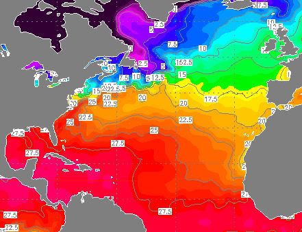
Tropical Depresion 3 is ontstaan in de oostelijke pacific.
Waarschijnlijk wordt het net een tropische storm en gaat dan weer uitwaaien
INITIAL 11/1600Z 15.7N 110.7W 30 KT
12HR VT 12/0000Z 16.2N 111.6W 35 KT
24HR VT 12/1200Z 17.1N 112.8W 35 KT
36HR VT 13/0000Z 17.7N 114.1W 30 KT
48HR VT 13/1200Z 17.7N 115.5W 25 KT...DISSIPATING
72HR VT 14/1200Z 17.5N 117.5W 20 KT...REMNANT LOW
96HR VT 15/1200Z...DISSIPATED
quote:MetOffice verwacht geen actief orkaanseizoen
Kwamen eerder Amerikaanse onderzoekers met prognoses voor een actief Atlantisch orkaanseizoen 2007, het Engelse MetOffice verwacht een seizoen met een iets minder dan gemiddeld aantal tropische stormen.
Volgens MetOffice is er 70% kans dat er in de periode juli t/m november 7 tot 13 tropische stormen gaan voorkomen, met als meest waarschijnlijke uitkomst 10. Het gemiddeld aantal stormen over deze maanden gedurende 1990-2005 bedroeg 12,4.
Het MetOffice gebruikt voor haar verwachting het zogenaamde GloSea model, ontwikkeld in samenwerking met het ECMWF. Dit is een dynamisch model dat gebruik maakt van de kennis over natuurkundige processen die een rol spelen bij het voorkomen van tropische systemen. De Amerikanen daarentegen gebruiken tot nog toe een statistisch model, dat uitgaat van in het verleden waargenomen correlaties tussen het aantal stormen en externe factoren. Het GloSea model scoorde vorig jaar ook goed, in tegenstelling tot de Amerikaanse prognoses. Die laatste verwachtten na een recordactief 2005 ook een bovengemiddeld actief 2006 seizoen. In werkelijkheid werd een heel gemiddeld Atlantisch orkaanseizoen.
In het huidige seizoen zijn tot nu toe twee (sub)tropische stormen voorgekomen, Andrea en Barry. Deze tellen echter niet mee voor de Engelse prognose, die vanaf juli telt.
Zie verder: link

Tropical Storm 03Bquote:Two areas of concern
Both the Atlantic and Pacific basins remain void of any tropical activity, and no tropical formation is expected in the near term.
This said, an area of showers and thunderstorms affecting northeast Nicaragua and the western Caribbean will clip eastern Honduras later today. While this convection is not associated with any area of low pressure, the tropical moisture will surge northward across the Yucatan and into the Gulf of Mexico this weekend. It is possible that by early next week, this tropical moisture will make it into some pasts of the southern United States.
Meanwhile, a newly formed tropical cyclone in the Indian Ocean could cross southern India and enter the Arabian Sea this weekend.
Groot complex is dit. Het kan India oversteken en daarna in de Arabische Zee terecht komen, waar het zich misschien ontwikkeld tot een orkaan.
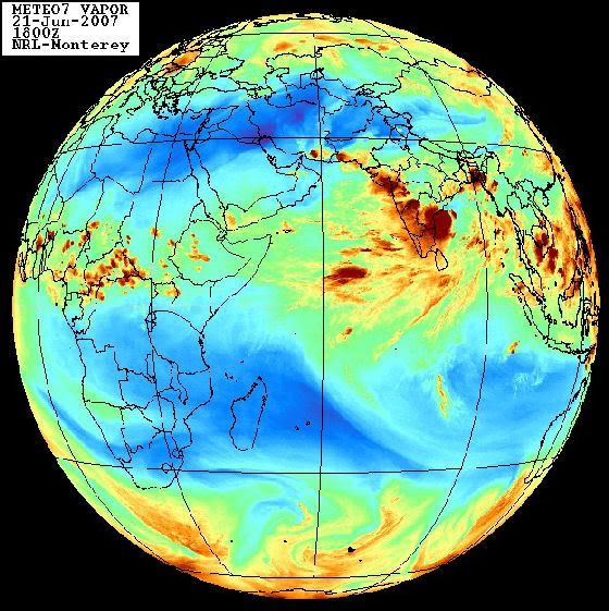
[ Bericht 6% gewijzigd door #ANONIEM op 21-06-2007 21:08:29 ]
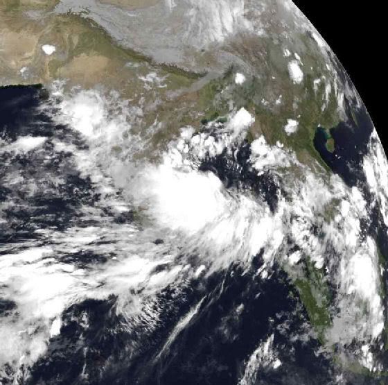
inderdaadquote:Op vrijdag 22 juni 2007 12:47 schreef Party_P het volgende:
Tjeem daar kan Nederland heeeeel erg vaak in, in die wolkencomplexen
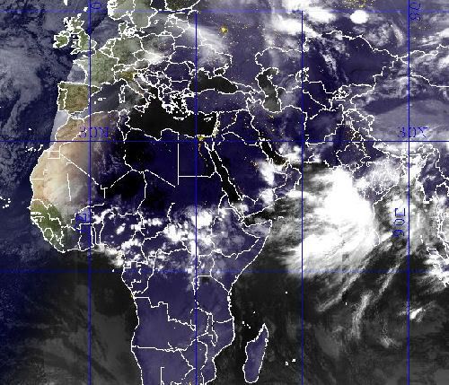
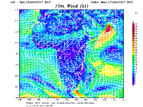
In Zuid-India zijn zeker 45 mensen om het leven gekomen door een tropische storm en hevige regen. Delen van de stad Nandyal staan onder water. Ruim 56.000 mensen moesten hun huis uit. Ook in het zuiden van China valt veel regen.
NOS
NOS
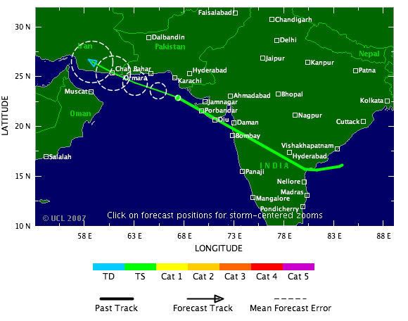
Nieuwe tropische cycloon boven Arabische Zee
De tropische cycloon 03B, die vorige week ontstond ten oosten van India boven de Golf van Bengalen, is inmiddels ten westen van India aangekomen en is opnieuw tot cycloonkracht aangesterkt boven de Arabische Zee.
Cycloon 3B koerst naar het westnoordwesten en zal nog iets kunnen aansterken. Het systeem zal waarschijnlijk dinsdagavond in het uiterste zuidoosten van Iran aan land komen, dicht bij de grens met Pakistan.
Tijdens de overtocht over India was het systeem drastisch afgezwakt en geen cycloon meer. Toch waren de restanten de afgelopen dagen mede debet aan de zware buien die in India en het zuiden van Pakistan honderden mensenlevens hebben gekost.

Tropical Cyclone 03B
Cyclonic storms in the Arabian Sea are rare, but not unheard of. Two tropical cyclones in the space of a month, on the other hand, is quite rare indeed. Unlike its predecessor, Tropical Cyclone Gonu, Cyclone 03B originated on the opposite side of the Indian Peninsula in the Bay of Bengal. At 11:10 a.m. local time (06:10 UTC) on June 25, 2007, when the Moderate Resolution Imaging Spectroradiometer (MODIS) on NASA’s Terra satellite captured this image, Tropical Cyclone 03B was reforming in the Arabian Sea south of the Pakistan coast after having crossed over India. The storm system has a discernable spiraling shape, but does not appear well-formed in this image. The storm has no distinct eye, suggesting that it is not particularly well organized. At the time, sustained winds were measured at 60 kilometers per hour (40 miles per hour) according to the University of Hawaii’s Tropical Storm Information Center.
The storm flooded India’s Andhra Pradesh province, resulting in 45 deaths, according to Weather Underground. It also caused flooding and wind damage in Karachi, Pakistan, where the death toll was around 200, according to BBC News. After crossing land, the storm reached the Arabian Sea and began to reform. As of June 26, forecasts were calling for the storm to gain some organization and power, skirt the Pakistani coast, and make landfall again somewhere near the border between Iran and Pakistan. Storm surge from Cyclone 03B was predicted to be moderately high, even though the storm is not strong, since the offshore waters are shallow, similar to the northern Gulf of Mexico. Because these kinds of storms are rare, coastal communities are particularly vulnerable to storm surge damage.
Doden in Pakistan door cycloon Yemyin
(Novum/AP) - De cycloon Yemyin, die dinsdag toesloeg in het kustgebied van de Pakistaanse provincie Baluchistan, heeft tot dusverre aan zeker twaalf mensen, onder wie vier kinderen, het leven gekost. Duizenden mensen zijn op de vlucht voor het door de storm voortrazende water vast komen te zitten op de daken van huizen en in de toppen van bomen.
Schepen en helikopters van de marine hebben rond de 125 opvarenden van door de storm overvallen schepen gered. Een onbekend aantal opvarenden wordt nog vermist. Dit hebben de autoriteiten woensdag bekendgemaakt. (nieuws.nl)
10 drown as cyclone hits Pakistan
A Pakistani man looks at the washed away Coastal Highway hit by Cyclone Yemyin at Aghor Tuesday.
QUETTA, Pakistan (AP) -- Ten people drowned and thousands fled to higher ground as a tropical cyclone lashed Pakistan's coastline with heavy rains and high winds, officials said.
Navy ships rescued 75 people from four floundering vessels Tuesday and were searching for more boats caught in the rough seas with the help of helicopters, said Navy spokesman Lt. Com. Salman Ali.
Cyclone Yemyin hit parts of the coastline of Baluchistan province at about noon with winds of up to 57 miles (91 kilometers) an hour, said Qamaruz Zaman, director-general of the Pakistan Meteorological Department.
Rain-swollen rivers flooded several coastal districts, killing at least 10 people, including four children, said Raziq Bugti, spokesman for the provincial government.
Floods washed away some bridges and part of the main coastal highway, causing lengthy traffic delays. Hundreds of villagers clutching possessions filed past the vehicles in the opposite direction.
In the hills, spillways were opened to release the water pressure on two dangerously full dams, Bugti said.
Relief efforts were hampered with roads and telephone lines severed in nine districts of the province.
Officials said the storm's intensity was decreasing and would subside by evening, but not before dumping heavy rains that could last through the night.
A Pakistani man looks at the washed away Coastal Highway hit by Cyclone Yemyin at Aghor Tuesday.
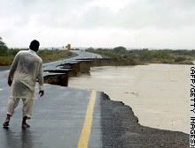
QUETTA, Pakistan (AP) -- Ten people drowned and thousands fled to higher ground as a tropical cyclone lashed Pakistan's coastline with heavy rains and high winds, officials said.
Navy ships rescued 75 people from four floundering vessels Tuesday and were searching for more boats caught in the rough seas with the help of helicopters, said Navy spokesman Lt. Com. Salman Ali.
Cyclone Yemyin hit parts of the coastline of Baluchistan province at about noon with winds of up to 57 miles (91 kilometers) an hour, said Qamaruz Zaman, director-general of the Pakistan Meteorological Department.
Rain-swollen rivers flooded several coastal districts, killing at least 10 people, including four children, said Raziq Bugti, spokesman for the provincial government.
Floods washed away some bridges and part of the main coastal highway, causing lengthy traffic delays. Hundreds of villagers clutching possessions filed past the vehicles in the opposite direction.
In the hills, spillways were opened to release the water pressure on two dangerously full dams, Bugti said.
Relief efforts were hampered with roads and telephone lines severed in nine districts of the province.
Officials said the storm's intensity was decreasing and would subside by evening, but not before dumping heavy rains that could last through the night.
04b
There continue to be no signs of tropical cyclone development in the Atlantic and Pacific Basins. While occasional clusters of thunderstorms do flare up, upper-level winds in the areas favorable for late June development (the Gulf of Mexico, the western Caribbean Sea, the southwest north Atlantic and the Pacific south of Mexico) are too strong to allow any tropical development.
However, an upper low and a tropical wave are bringing locally heavy rainfall to the Bahamas and increasingly to the Florida Peninsula, as tropical moisture increases over that area.
A tropical cyclone with tropical storm strength winds in the Bay of Bengal will move into India, producing another flooding rain event.
bron
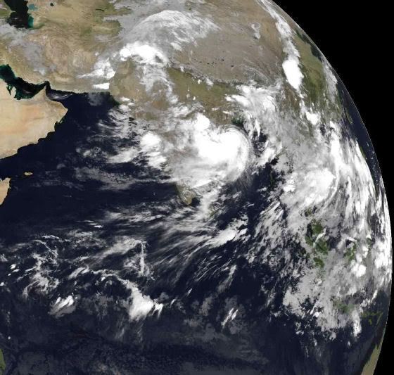

Er is een nieuwe storm ontstaan.
Tot nu toe heet hij 04W. Het lijkt een behoorlijk zware storm te worden !
Tot nu toe heet hij 04W. Het lijkt een behoorlijk zware storm te worden !


Ziet er indrukwekkend uit.quote:Op zaterdag 7 juli 2007 16:26 schreef DForce het volgende:
Er is een nieuwe storm ontstaan.
Tot nu toe heet hij 04W. Het lijkt een behoorlijk zware storm te worden !
[afbeelding]
[afbeelding]
Gaat zeker een categorie 1 worden en missichien wel meer.
foto van 15.00 uur 7 juli 2007

Volgens de laatste voorspellingen gaat het een catogorie 4 worden !
En hij lijkt tot nu toe richting de Chineese kust te gaan !
En hij lijkt tot nu toe richting de Chineese kust te gaan !
In de gaten houden dan maar
<a href="https://www.youtube.com/channel/UCPueUwKfPaGH7v48LZlltkg" rel="nofollow" target="_blank">WSDokkum Youtube</a>
quote:Rather large Tropical Storm Man-Yi (65 mph) is expected to strengthen into a powerful typhoon in the western Pacific. Man-Yi, centered about 275 miles southwest of Guam, is forecast to reach typhoon strength within the next 12 hours.
The storm will move generally northwestward this week, and is predicted to crank up to a 145-mph monster by Friday (U. S. time). By then, Man-Yi could be doing some saber rattling aimed at either Taiwan or Okinawa.
Closer to home, a large low pressure area moving northwestward about 675 miles southwest of Cabo San Lucas, Mexico, still has the potential to develop into a tropical depression over the next day or two. After that, it will encounter a less favorable environment for strengthening.
The tropical Atlantic Basin, meanwhile, remains quiet.
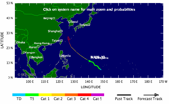
Deze gaat voor veel ellende zorgen
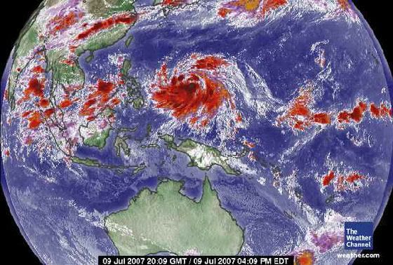
In de East Pacific is een Depressie ontstaan !!
Heel mischien wordt het nog een minimaale tropische storm !!
Niet erg heftig dus ...
Heel mischien wordt het nog een minimaale tropische storm !!


Niet erg heftig dus ...
Tropische storm Man-Yi is dinsdagochtend uitgegroeid tot een volwaardige tyfoon. Dinsdagochtend om 08.00 uur bereikte Man-Yi windsnelheden van 120 kilometer per uur en werden er windstoten van 148 kilometer per uur.
Woensdagnacht om 02.00 bereikte de tyfoon windsnelheden van 148 kilometer per uur met windstoten tot 185 kilometer per uur. Woensdag ligt de tyfoon op open zee en neemt dan nog in kracht toe.
De verwachting is dat Man-Yi zich donderdag ontwikkelt tot een krachtige tyfoon. Hij beweegt zich met 24 kilometer per uur naar het noordwesten. Naar verwachting buigt de storm vrijdag af naar het noord-noordoosten en zal Taiwan schampen. Daarna zal de tyfoon recht afstevenen op de Riukiu eilanden en Japan.
weeronline

Kan voor Japan nog wel een probleem gaan opleveren idd... ziet er weer 'rood' uit daar op het kaartje
ik zit momenteel in Taiwan... 2 dagen geleden nog lichte zorgen omdat er een kans was dat deze Taiwan als een cat4 ging hitten... Echter buigt deze nu af en gaat bijna zeker Okinawa vol raken als cat 4.......quote:Op woensdag 11 juli 2007 13:21 schreef aloa het volgende:
Tropische storm Man-Yi is dinsdagochtend uitgegroeid tot een volwaardige tyfoon. Dinsdagochtend om 08.00 uur bereikte Man-Yi windsnelheden van 120 kilometer per uur en werden er windstoten van 148 kilometer per uur.
Woensdagnacht om 02.00 bereikte de tyfoon windsnelheden van 148 kilometer per uur met windstoten tot 185 kilometer per uur. Woensdag ligt de tyfoon op open zee en neemt dan nog in kracht toe.
De verwachting is dat Man-Yi zich donderdag ontwikkelt tot een krachtige tyfoon. Hij beweegt zich met 24 kilometer per uur naar het noordwesten. Naar verwachting buigt de storm vrijdag af naar het noord-noordoosten en zal Taiwan schampen. Daarna zal de tyfoon recht afstevenen op de Riukiu eilanden en Japan.
weeronline
Totaal Travel 04-24: 87 reizen, 151 vliegtickets, 58 landen, 6 continenten, 949 reisdagen, 163.804 foto's
Mijn reisfotos!
Mijn reisfotos!
Okinawa wordt vol getroffen.quote:Op woensdag 11 juli 2007 17:30 schreef ETA het volgende:
[..]
ik zit momenteel in Taiwan... 2 dagen geleden nog lichte zorgen omdat er een kans was dat deze Taiwan als een cat4 ging hitten... Echter buigt deze nu af en gaat bijna zeker Okinawa vol raken als cat 4.......
Foto van 15.00 uur vandaag.
Groot oog heeft deze orkaan
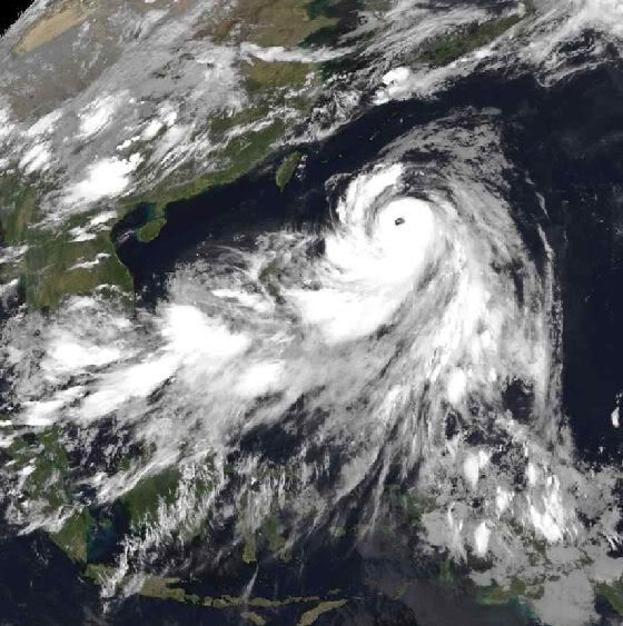
Ik denk dat taiwan nog wel de nodige neerslag krijgt.
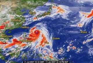
Ja zeg doe me een lol......dit is 1 van de weinige topics die tenminste goed info bevat en waar zeer weinig wordt gechat....wees eens blij voor de users die dit bij houden! Petje af voor jullie
<a href="https://www.youtube.com/channel/UCPueUwKfPaGH7v48LZlltkg" rel="nofollow" target="_blank">WSDokkum Youtube</a>

Mischien gaat het kwa regen wel meevallen maar met de wind zeker niet.
windsnelheden : 231km per uur
windvlagen : 278km per uur
Het zou mijn niet verbazen als Man-Yi ook nog een catogorie 5 wordt.
windsnelheden : 231km per uur
windvlagen : 278km per uur
Het zou mijn niet verbazen als Man-Yi ook nog een catogorie 5 wordt.
Idd. GFS onderschat het een beetje .quote:Op donderdag 12 juli 2007 00:32 schreef DForce het volgende:
Mischien gaat het kwa regen wel meevallen maar met de wind zeker niet.
windsnelheden : 231km per uur
windvlagen : 278km per uur
Het zou mijn niet verbazen als Man-Yi ook nog een catogorie 5 wordt.
Op google.com komen de eerste nieuwsberichten ook al binnen.
quote:Man-Yi Strengthens Into Category Four Storm, Heads Toward Japan
Bron : Bloomberg
July 12 (Bloomberg) -- Typhoon Man-Yi strengthened into a Category Four storm with maximum sustained winds of 212 kilometers per hour (132 miles an hour) in the Pacific Ocean as it headed for Okinawa in Japan, U.S. Navy forecasters said.
The center of Man-Yi, the fourth named storm of this year's western Pacific cyclone season, was 751 kilometers south- southeast of Naha, on the island of Okinawa, at 3 a.m. Japan time today, the latest advisory on the U.S. Navy Joint Typhoon Warning Center's Web site said.
Japan is regularly buffeted by tropical cyclones during the northern hemisphere's summer and nine people died when Kyushu was hit by Typhoon Shanshan in September last year. A record 10 tropical storms and typhoons hit the country in 2004, killing more than 60 people and causing billions of dollars of damages.
Man-Yi was moving northwest at 31 kilometers an hour and the storm is forecast to turn more to the north before passing over Okinawa late today or early tomorrow. By then, forecasters expect its maximum sustained winds to reach 230 kilometers an hour.
The storm's winds were gusting to 258 kilometers per hour near its center and typhoon-strength winds of 118 kilometers an hour extend out 101 kilometers from the eye, the Navy said. Waves are as high as 9.5 meters (31 feet) near Man-Yi's center.
The eye of Man-Yi is expected to cross Okinawa and swing northeast, skirting the southern coasts of Kyushu, Shukoku and western Honshu before passing over Tokyo in the early hours of July 15. By then, the storm is expected to weaken, with winds slowing to 138 kilometers per hour.
The typhoon is a Category Four storm, the second-strongest on the five-step Saffir-Simpson scale.
Man-Yi is the name of an old strait in Hong Kong that was dammed and turned into a reservoir, according to the Web site of the Hong Kong Observatory, which lists cyclone names in use in the Pacific.
Windspeeds of Tyfoon Man-Yi
Typhoon Man-yi formed as a tropical depression in the western Pacific on July 8, 2007, among the islands of Micronesia. The storm gradually built power to typhoon status on July 10. As of July 11, forecasters were calling for Man-Yi to strengthen to Category 4 (Super Typhoon) status, with sustained winds in the storm’s core predicted to reach at least 210 kilometer per hour (131 miles per hour).
This data visualization of the storm shows observations form the QuikSCAT satellite on July 9, 2007, at 20:58 UTC (8:58 a.m. local time, July 10). At this time, Man-Yi appeared as a well-developed storm system, but had not yet reached typhoon status; it’s peak winds were around 110 km/hr (65 mph; 60 knots). The image depicts wind speed in color and wind direction with small barbs. White barbs point to areas of heavy rain.
QuikSCAT measurements of the wind strength of Man-Yi and other tropical cyclones can be slower than actual wind speeds. QuikSCAT’s scatterometer sends pulses of microwave energy through the atmosphere to the ocean surface and measures the energy that bounces back from the wind-roughened surface. The energy of the microwave pulses changes depending on wind speed and direction.
To relate the radar signal to actual wind speed, scientists compare measurements taken from buoys and other ground stations to data the satellite acquired at the same time and place. Because the high wind speeds generated by cyclones are rare, scientists do not have corresponding ground information to know how to translate data from the satellite for wind speeds above 50 knots (about 93 km/hr or 58 mph).
Also, the unusually heavy rain found in a cyclone distorts the microwave pulses in a number of ways, making a conversion to exact wind speed difficult. Instead, the scatterometer provides a nice picture of the relative wind speeds within the storm and shows wind direction.
Argh, ik heb al een kaartje gekocht om zondagochtend vanaf Tokyo naar Zuid-Korea te vliegen (en hotel geboekt..), maar ik verwacht dat de vliegtuigen wel aan de grond zullen blijven. Grmbl. Beter blijft die typhoon nog even boven zuid-Japan hangen...
They told me all of my cages were mental, so I got wasted like all my potential.