WKN Weer, Klimaat en Natuurrampen
Lees alles over het onstuimige weer op onze planeet, volg orkanen en tornado's, zie hoe vulkanen uitbarsten en hoe Moeder Aarde beeft bij een aardbeving. Alles over de verwoestende kracht van onze planeet en tal van andere natuurverschijnselen.


Hier is dan het nieuwe topic voor Hurricane Season 2007 voor zowel Atlantische, Indische als Pacifische stormen.
Algemene Info
Met de term 'Hurricane Season' bedoelden we in eerste instante de periode van 1 juni tot 30 november.
Deze periode wordt in het Atlantische basin en de Golf van Mexico gezien als het “Stormen-seizoen Echter komen deze geweldadige stormen overal in de wereld voor en met name in Azie zorgen ze jaarlijks voor honderden slachtoffers en duizenden daklozen. Echter horen we erg weinig over de stormen in Azie en juist meer over die in de VS.
Naar aanleiding van documentairs over Hurricane Andrew 1992 en de newsberichten van de laatste jaren over o.a. Floyd, Stan en Ivan en natuurlijk de catastrofe "Katrina" beginnen we ook voor 2007 met een nieuw topic. Hoewel het Amerikaanse seizoen pas in Juni begint zijn er op andere plekken in de wereld zeker meer orkanen te vinden in de komende maanden. We zullen ook deze dus zeker gaan bespreken. Waarschijnlijk zal de kern van de discussie en de posts gaan over de periode 1-6-2006 t/m 30-11-2006. Daarvoor zal het wel niet storm gaan lopen
Waarschijnlijk zal er t.z.t. ook wel een NWS-topic worden geopend als een orkaan ook uitgebreid in het nieuws.
Hoe ontstaan ze?
op de site van Wikipedia kan je in het Nederlands nalezen hoe ze ontstaan en wat de belangrijkste energiebron is voor hun verwoestende kracht: het warme zeewater http://nl.wikipedia.org/wiki/Orkaan#Ontstaan
De BBC heeft er een interessante en leuke gif over gemaakt (met dank aan Roel)
http://news.bbc.co.uk/2/hi/science/nature/4588149.stm
Ook wordt er op LiveScience in het engels prima uitgelegd hoe ze ontstaan en zich ontwikkelen http://www.livescience.co(...)icane_formation.html
Indeling en Kracht
De stormen worden ingedeeld op categorie. Vaak zijn het eerst "tropische stormen" (Tropical Depression, Tropical Storms), die overgaan op Orkaanstatus (Hurricane) Ze worden ingedeeld op windsnelheden via de Saffire Simpson Schaal
Tropical Depression 24-38 mph winds (38-61 km/u)
Tropical Storm 39-73 mph winds (62-118 km/u)
Hurricane Categorie 1 74-95 mph winds (119-153 km/u) -- 4/5 ft Storm Surge -- Vb. Danny 1997, Stan 2005
Hurricane Categorie 2 96-110 mph winds (154-177 km/u) - 6/8 ft Storm Surge -- Vb. Danielle 2004
Hurricane Categorie 3 111-130 mph winds (178-209 km/u) -- 9/12 ft Storm Surge -- Vb.Fran 1996, Beta 2005
Hurricane Categorie 4 131-155 mph winds (210-249 km/u) -- 13/18 ft Storm Surge -- Vb.Hugo 1989, Frances 2004
Hurricane Categorie 5 > 156 mph winds (meer dan 250 km/u) -- 18ft or more S.S. -- Vb.Andrew 1992, Mitch 1998 en Wilma, Katrina 2005
Namen
De stormen, die vaak gevormd worden op de atlantische oceaan en dan richting de Caribbean of de Oostkust van de VS gaan, krijgen de naam op Alfabetische volgorde. Voor het seizoen 2005 zijn de namen als volgt:
Atlantische Stormen 2007
Andrea, Barry, Chantal, Dean, Erin, Felix, Gabrielle, Humberto, Ingrid, Jerry, Karen, Lorenzo, Melissa, Noel, Olga, Pablo, Rebekah, Sebastien, Tanya, Van, Wendy
In het oosten van de pacific ontstaan ook Hurricanes, ook wel Cylonen en/of Tyfoons genoemd. Deze zorgen vaak voor weinig schade aan de Amerikaanse westkust.
Oost Pacifische Stormen 2007
Alvin, Barbara, Cosme, Dalia, Erick, Flossie, Gil, Henriette, Ivo, Juliette, Kiko, Lorena, Manuel, Narda, Octave, Priscilla, Raymond, Sonia, Tico, Velma, Wallis, Xina, York, Zelda
Verder zijn er dan nog de stormen in het Noorden, Zuiden en Westen van de Pacific. Met name de stormen in het Noord/Westen komen vaak in het nieuws omdat ze Japan, Taiwan en China vaak teisteren, maar ook geheel Zuid Oost Azie kunnen treffen. De namen van deze stormen zijn terug te vinden op
[url]http://www.nhc.noaa.gov/aboutnames.shtml[url]
Wanneer zijn die seizoenen nou precies?
ATLANTIC: 1 mei t/m 30 november
NORTH EAST PACIFIC Begin mei t/m begin November, met piek in Augustus/September
NORTH WEST PACIFIC Begin juli t/m eind November, maar eigenlijk hele jaar door aktiviteit.
NORTH INDIAN April t/m December met pieken in Mei en November
SOUTH INDIAN + WEST AUSTRALIAN Oktober t/m Mei met pieken in Februari en April
SOUTH WEST PACIFIC + EAST AUSTRALIANOktober tot eind April met piek in Februari.
Over het algemeen is Mei de rustigste maand en September de ergste.
Hoe ziet de voorspelling voor 2007 eruit
Volgens Phil Klotzbach en William Gray van CSU wordt 2007 een actief jaar dat ze 'boven gemiddeld' noemen. Deze 'voorlopige' voorspelling deden ze op 8 december 2006. Ze voorspellen dan ook dat er 14 stormen komen die een naam krijgen, waarvan er 7 uitgroeien tot een orkaan. Van deze zeven zijn er 3 van Categorie 3 of hoger.
Verder voorspellen ze dat er 64% kans is dat er een zware orkaan in 2007 het gebied rondom Florida treft en dat er 40% kans is dat een orkaan de Oostkust van de VS aan doet. Vooral dit laatste vrezen de Amerikanen al jaren, want een 'lichte' Categorie 1 of 2 storm zou voor miljarden schade kunnen doen aan de dichtbevolkte oostkust van de VS.
(PS: Vorig jaar zaten beide heren er heel erg naast... )
Oude Delen
2004 - Deel 1 Hurricane Season 2004 en Deel 2 Hurricane Season 2004 -- Part 2
2005 - Deel 1 Tropical Cyclone Season 2005 en Deel 2 Hurricane/Cyclone Season 2005 - Part 2
2006 - Deel 1 [WFL] Hurricane Season 2006 en Deel 2 Hurricane Season 2006 #2
Enkele Links
1. Hurricane Season Special Edition Pagina van CNN van 2006
2. National Hurricane Centre
3. Carribean Storm Network
4. Florida University Hurricane Website
5. Action News from Florida + Webcams
6. Hurricane Track
7. Website met satelietbeelden van de Caribbean en de rest van Amerika
8. Intellicast: Geavanceerde satellietfoto's en gifs van aktuele stormen
9. Data over temperatuur / wind
10. Tropical Storm Risico's van dit moment
11. Actuele Watertemperatuur van dit moment
12. Wikipedia Hurricanes/Tyfonen in het algemeen
13. Overzicht aktuele typhoons in de pacific
14. Alle stormen ter wereld van de laatste jaren in overzicht
15. The StormTrack
Opmerkelijke Links
-- Hurricane Katrina CNN Special Report of the Killer Hurricane
-- Hurricane Katrina via WikiPedia
-- Hurricane Season 2005 -- Special van CNN
-- Hurricane Season 2004 -- Special van CNN
– Overzicht van Atlantische Stormen uit 2005
-- Spectaculaire Satelietshots van stormen
--Animatie van de alle Atlantische Stormen uit 2004
Openingspost
Klik hier
Actuele Radar in Golf van Mexico

Water temperatuur.
Last Update: 28-05-2007
=====================
Post hier je gegevens, nieuwsberichten, data en/of opmerkelijke zaken over de ‘Hurricanes en Cyclonen’ van 2007
[ Bericht 0% gewijzigd door Frutsel op 10-06-2007 18:04:44 ]
TS Glovis mag zich de eerste van 2007 noemen
[ Bericht 24% gewijzigd door Frutsel op 03-01-2007 11:16:39 (plaatje toegevoegd) ]

[ Bericht 24% gewijzigd door Frutsel op 03-01-2007 11:16:39 (plaatje toegevoegd) ]

Begint al goedquote:Op maandag 1 januari 2007 19:22 schreef Frutsel het volgende:
TS Glovis mag zich de eerste van 2007 noemen
[afbeelding]
Doe mee met het voorspellen van het weer!
Weekvoorspelling | Week 12 (invullen tot 16-03 - 11:59)
Maandvoorspelling Maart (Inzendingen gesloten)
Jaarvoorspelling 2025 / 2026
Weekvoorspelling | Week 12 (invullen tot 16-03 - 11:59)
Maandvoorspelling Maart (Inzendingen gesloten)
Jaarvoorspelling 2025 / 2026

Stond nog een klein foutje in.quote:Op maandag 1 januari 2007 20:30 schreef Frutsel het volgende:
[..]
neem jij de OP weer voor je rekening? ff updaten?
quote:Post hier je gegevens, nieuwsberichten, data en/of opmerkelijke zaken over de ‘Hurricanes en Cyclonen’ van 2006 moet zijn 2007
hehehe... dat klopt idd.. ik was er gisteren al druk mee en drukte een verkeerde toets en alles was weg... frustratie ten top... daarna opnieuw moeten doen... en dat idd vergeten thxquote:Op maandag 1 januari 2007 20:33 schreef Drugshond het volgende:
[..]
Stond nog een klein foutje in.
[..]
Doe mee met het voorspellen van het weer!
Weekvoorspelling | Week 12 (invullen tot 16-03 - 11:59)
Maandvoorspelling Maart (Inzendingen gesloten)
Jaarvoorspelling 2025 / 2026
Weekvoorspelling | Week 12 (invullen tot 16-03 - 11:59)
Maandvoorspelling Maart (Inzendingen gesloten)
Jaarvoorspelling 2025 / 2026
Misschien is het beter om de vraag hier te stellen: waarom komen orkanen in de regel alleen op het noordelijk halfrond voor?
"End this war against drugs. Legalise the drug against wars."
-
[b]Op donderdag 28 september 2006 09:12 schreef Rio het volgende:[/b]
Uiteindelijk is dit een star_gazer-krijgt-een-keiharde-lul-van-zichzelf-omdat-hij-zichzelf-verheven-voelt topic.
-
[b]Op donderdag 28 september 2006 09:12 schreef Rio het volgende:[/b]
Uiteindelijk is dit een star_gazer-krijgt-een-keiharde-lul-van-zichzelf-omdat-hij-zichzelf-verheven-voelt topic.

Goeie OP trouwens
"End this war against drugs. Legalise the drug against wars."
-
[b]Op donderdag 28 september 2006 09:12 schreef Rio het volgende:[/b]
Uiteindelijk is dit een star_gazer-krijgt-een-keiharde-lul-van-zichzelf-omdat-hij-zichzelf-verheven-voelt topic.
-
[b]Op donderdag 28 september 2006 09:12 schreef Rio het volgende:[/b]
Uiteindelijk is dit een star_gazer-krijgt-een-keiharde-lul-van-zichzelf-omdat-hij-zichzelf-verheven-voelt topic.
Dank je! Al is hij grotendeels uit WFL overgenomen van de lopende topics daar hoorquote:Op maandag 1 januari 2007 21:34 schreef star_gazer het volgende:
Goeie OP trouwens
Ze komen wel degelijk voor op het zuidelijk halfrond, rondom Australië en zoals nu Madagascar... alleen in veel mindere mate. Ik denk dat het te maken heeft met de zeestromingen al kan ik dat niet bevestigen. Dat moeten we op gaan zoekenquote:Op maandag 1 januari 2007 21:32 schreef star_gazer het volgende:
Misschien is het beter om de vraag hier te stellen: waarom komen orkanen in de regel alleen op het noordelijk halfrond voor?
Ik denk dat het afhankelijk is van vele condities (ff los uit de pols).
Water temperatuur
Convectie.
Koude en warme golfstromen.
Een warme zomer.
En een hoog en een laag drukgebied. (weet niet zeker).
Schijnbaar zijn de condities op het Noordelijk hafrond gewoon beter waardoor die dingen kunnen ontstaan.
Schijnbaar zijn de condities op het Noordelijk hafrond gewoon beter waardoor die dingen kunnen ontstaan.

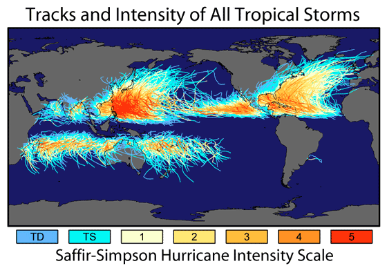
Hier een kaartje van orkanen van een aantal jaren lang.
Op de website http://www.globalwarmingart.com is een kaart verschenen met banen van alle tropische systemen. De systemen in de Atlantische Oceaan gaan terug tot 1860, de rest tot 1960.
Duidelijk is dat de zwaarste orkanen niet bij de Verenigde Staten voorkomen, maar bij Azië. Verder is te zien dat op het midden van de Stille Oceaan nauwelijks orkanen ontstaan.
De tropische systemen komen op de Atlantische Oceaan noordelijker en weten een enkele keer de Noordzee te bereiken of koudere gebieden. En voor de mensen die op details letten. Let ook even op de twee tropische systemen die de woestijn van Australië overleefden.
bron: VWK
Das een topplaatje! Vermelding in eventuele nieuwe OP-waardig!quote:Op maandag 1 januari 2007 22:23 schreef aloa het volgende:
Hier een kaartje van orkanen van een aantal jaren lang.
[afbeelding]
knip

Waarom hier nou niet
Ach ja, 2de alweer
Ach ja, 2de alweer
Doe mee met het voorspellen van het weer!
Weekvoorspelling | Week 12 (invullen tot 16-03 - 11:59)
Maandvoorspelling Maart (Inzendingen gesloten)
Jaarvoorspelling 2025 / 2026
Weekvoorspelling | Week 12 (invullen tot 16-03 - 11:59)
Maandvoorspelling Maart (Inzendingen gesloten)
Jaarvoorspelling 2025 / 2026
Orkanen onstaan meestal uit samenklonteringen van onweersbuien die ontstaan in de Intertropische Convergentiezone (ITCZ): http://www.vwkweb.nl/cms/index.php?option=com_content&task=view&id=375quote:Op maandag 1 januari 2007 21:52 schreef Drugshond het volgende:
Ik denk dat het afhankelijk is van vele condities (ff los uit de pols).Water temperatuur Convectie. Koude en warme golfstromen. Een warme zomer. En een hoog en een laag drukgebied. (weet niet zeker).
Schijnbaar zijn de condities op het Noordelijk hafrond gewoon beter waardoor die dingen kunnen ontstaan.
Door rotatie van de aarde zal er op den duur een draaiende beweging in het geheel komen. Maar dat gebeurd pas bij 5 graden NB/ZB of hoger(/lager, het is maar hoe je het ziet ). Als zo'n complex te dicht bij de evenaar blijft zal er ook geen orkaan ontstaan.
Verder heeft het natuurlijk te maken met de temperatuur van het zeewater. Orkanen hebben zeewater van minimaal 28 graden nodig om zichzelf te voeden. Komen ze boven kouder water (of boven land) dan zwakken ze vrij snel af. Ik ben niet zo thuis in oceaanstromingen, maar ik vermoed dat er boven het zuidelijk halfrond veel minder warm water is. Verder is de ICTZ volgens mij ook kleiner op het zuidelijk halfrond.
Cause I'd rather continue my trip to the top of the mountain then freeze to death in the valley.
quote:Cycloon snel van de kaart
Bron : weathernews.nl
Geplaatst op: 4 Januari 2007
Op de eerste dag van dit jaar lag tropische cycloon Clovis boven de Indische Oceaan en stevende op Madagaskar af. Op 2 januari zwelde het systeem nog wat aan, maar gelukkig voor de eilandbewoners nam hij gisteren in kracht af.
Gisterenavond werd windkracht 9 gemeten, waardoor Clovis degradeerde tot een tropische storm. Vanochtend vroeg waaide het stormachtig, windkracht 8 en op Madagaskar deed Clovis zich gelden als een gewone depressie met heftige regen- en onweersbuien.
De inzetfoto laat Clovis zien toen hij gisteren overdag nog een echte cycloon was. Het andere plaatje toont het afgelegde traject. Op de bewegende satellietbeelden van Weathernews is goed te zien hoe snel het systeem in betekenis afneemt.

Regio Taiwan krijgt idd elk jaar veel meer en zwaardere orkanen te verduren als de VSquote:Op maandag 1 januari 2007 22:27 schreef Drugshond het volgende:
Ik weet wel dat Taiwan elk jaar een of meerdere keren in de prijzen valt.
We horen er hier alleen nauwelijks iets van meestal
silence can say more than thousand words
Een tekenend artikel, het klimaat in de VS is een klimaat waarin het klimaat moeilijk bespreekbaar is.
Hurricane center chief issues final warning click
A departing Max Mayfield is convinced that the Southeast is inviting disaster.
By Carol J. Williams, Times Staff Writer
January 3, 2007
Goeie OP, toppie
[ Bericht 2% gewijzigd door francorex op 06-01-2007 00:18:09 ]
Hurricane center chief issues final warning click
A departing Max Mayfield is convinced that the Southeast is inviting disaster.
By Carol J. Williams, Times Staff Writer
January 3, 2007
quote:Frustrated with people and politicians who refuse to listen or learn,
National Hurricane Center Director Max Mayfield ends his 34-year government career today in search of a new platform for getting out his unwelcome message:
Hurricane Katrina was nothing compared with the big one yet to come.

Hurricane season, orkaan seizoen 2007 welkom, en hallo stormwatchers.quote:But Mayfield warns that 10 times as many fatalities could occur in what he sees as an inevitable strike by a huge storm during the current highly active hurricane cycle, which is expected to last another 10 to 20 years.
Goeie OP, toppie
[ Bericht 2% gewijzigd door francorex op 06-01-2007 00:18:09 ]
Dan staat ze nog aardig wat te wachten als dat uitkomt.. zeker wanneer de kust dan nog niet verstevigd is, kan dat behoorlijke problemen opleveren..quote:Op vrijdag 5 januari 2007 23:30 schreef francorex het volgende:
Een tekenend artikel, het klimaat in de VS is een klimaat waarin het klimaat moeilijk bespreekbaar is.
Hurricane center chief issues final warning click
A departing Max Mayfield is convinced that the Southeast is inviting disaster.
By Carol J. Williams, Times Staff Writer
January 3, 2007
[..]
[afbeelding]
[..]
Hurricane season, orkaan seizoen 2007 welkom, en hallo stormwatchers.
Goeie OP, toppie
Hunting for Hurricanes in Africa
US atmospheric scientist Greg Jenkins takes his job hunting hurricanes off the coast of West Africa very personally.
"I had a lot of friends and relatives who really suffered when Hurricane Katrina hit New Orleans," he said.
"If we can get a better understanding of how these things form here in West Africa, we'll be able to extend our forecasting, and give people more time to get out of the way."
Mr Jenkins has swapped his job in Howard University in Washington State, for Dakar university in Senegal.
With his colleagues, he watches a short animated film again and again - satellite images of clouds over West Africa; the swirling, turbulent masses of moisture mixing and blending and separating in a mind-bogglingly complicated dance.
Outside, beneath the real black and grey clouds, wind turbines churned, harvesting data that is helping the scientists make sense of their mission.
This is to understand the weather systems that form over West Africa, head out across the Atlantic Ocean, and spin up into devastating hurricanes that ultimately batter the United States East Coast
Saharan air
The project is called the "Nasa African Monsoon Multidisciplinary Analyses" (Namma) and as the name implies, it draws in experts from a range of disciplines.
The team of technical and scientific brains came from Nasa, and an array of American universities, and French and Senegalese institutions.
Storm systems from the Sahara can turn into severe hurricanes
Between 80 and 100 storm systems form each year as bodies of hot, dry air over the Sahara Desert, pick up moisture as they move out across the Atlantic.
They get their initial power and instability from the difference in temperature between the very hot Sahara air and the substantially cooler air along the coast of the Gulf of Guinea.
Most peter out, shedding their energy along the way, but a few - about 10% - build power, becoming great, hulking behemoths that smash their way through the Caribbean Islands, and into the United States and Mexico.
Mr Jenkins and his team want to know what makes a hurricane.
To do it, they assembled an impressive array of technology: Nasa weather satellites provided sophisticated imagery from above; radars based in Senegal and the Cape Verde Islands further west gave a long-range view from the ground.
One of the radar analysts, atmospheric scientist Paul Kucera, said the West African weather systems are poorly understood.
"What we're learning is how storms evolve in this part of the region... their dynamics, their life-cycle, their internal characteristics that are unique to this region, that have never really been observed before by radar," he said.
Inside storm systems
But while the satellites and radar give important clues about what is going on inside the storms, neither are substitutes for a first-hand look.
To do that, the team called on two aircraft crammed with sophisticated sensors - a French Falcon and a DC-8 from Nasa - that flew through the heart of the storms to complete the picture.
Back at the Dakar university, the scientists debated which of the storms to send the Falcon through.
"It's really important that we find the weather systems that will build into hurricanes," said Mr Jenkins.
"The aircraft collects all sorts of data that we couldn't get any other way. It gives us a much better understanding of what's going on inside the storm systems; and helps us calibrate the satellites and understand what they are telling us from above."
The field work ended last September, but the researchers are continuing to analyse the mountain of data they managed to harvest.
Mr Jenkins believes it could be years before they come up with any definitive results, but they will ultimately improve the accuracy of existing forecasting models.
Inderdaad!quote:Op dinsdag 23 januari 2007 16:03 schreef aloa het volgende:
Daar is er al 1
Omgedoopt tot Cyclone Zita

Komt voorlopig ook nietquote:Op woensdag 24 januari 2007 11:28 schreef Drugshond het volgende:
qua Hurricans hebben we nog niet veel gezien in de golf van Mexico.
en vorig jaar was het een extreem rustig jaar voor hun
Stilte voor de storm ?
En de volgende krijgt de naam Arthur
Deze zit in hetzelfde gebied als Zita
[ Bericht 3% gewijzigd door #ANONIEM op 24-01-2007 21:50:19 ]
Deze zit in hetzelfde gebied als Zita
[ Bericht 3% gewijzigd door #ANONIEM op 24-01-2007 21:50:19 ]
Denk eerder stilte na de storm, aangezien 2005 een ongekend zwaar jaar was qua orkanen.quote:Op woensdag 24 januari 2007 11:29 schreef Frutsel het volgende:
[..]
Komt voorlopig ook niet
en vorig jaar was het een extreem rustig jaar voor hun
Stilte voor de storm ?
Dit jaar zou het qua hevigheid nog wel mee vallen denk ik volgend jaar weer een big bang
Doe mee met het voorspellen van het weer!
Weekvoorspelling | Week 12 (invullen tot 16-03 - 11:59)
Maandvoorspelling Maart (Inzendingen gesloten)
Jaarvoorspelling 2025 / 2026
Weekvoorspelling | Week 12 (invullen tot 16-03 - 11:59)
Maandvoorspelling Maart (Inzendingen gesloten)
Jaarvoorspelling 2025 / 2026

Hoezo denk je dat? De natuur houdt zich niet aan een bepaald schema of zo hoor.quote:Op maandag 29 januari 2007 18:18 schreef SpeedyGJ het volgende:
Dit jaar zou het qua hevigheid nog wel mee vallen denk ik volgend jaar weer een big bang
Zeg ook maar wat hoorquote:Op dinsdag 30 januari 2007 16:47 schreef Eveli het volgende:
[..]
Hoezo denk je dat? De natuur houdt zich niet aan een bepaald schema of zo hoor.
Doe mee met het voorspellen van het weer!
Weekvoorspelling | Week 12 (invullen tot 16-03 - 11:59)
Maandvoorspelling Maart (Inzendingen gesloten)
Jaarvoorspelling 2025 / 2026
Weekvoorspelling | Week 12 (invullen tot 16-03 - 11:59)
Maandvoorspelling Maart (Inzendingen gesloten)
Jaarvoorspelling 2025 / 2026

Maar is consistent met de gedachte dat El Nino afgelopen orkaan seizoen afgezwakt zou hebben; dat ding is nog niet over. Hoewel september nog een eind weg is.quote:
Ze hadden het er al dagen over, maar uiteindelijk toch nog ge-upgrade naar een TS. Nelson brengt al dagen zwaar weer in Noord Australië

Hurricane reasearch flights grounded click
thursday 7 2007
thursday 7 2007
quote:For the first time since NOAA began flying research aircraft into hurricane in the 1950's, there is no money to fund airborne hurricane research for an upcoming hurricane season. NOAA's state-of-the-art flying weather research laboratories, the two P-3 Orion hurricane hunter aircraft, may sit idle this hurricane season due to a lack of funding.

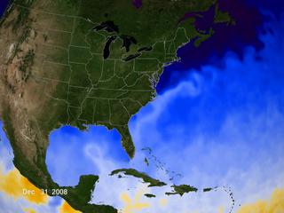
Favio op weg naar de Oostkust van de VS
Tropical Cyclone Favio formed in the western Indian Ocean about 1,200 kilometers from Madagascar on February 14, 2007. It gradually moved southwest, passing well offshore of Reunion and Mauritius Islands. By February 20, it was just off the southern shore of Madagascar as a well-formed, mature storm. While the storm system had largely skirted around populated areas to that point, forecasters were concerned about its behavior as it entered the warmer waters of the Mozambique Channel. The storm was forecast to reach Category Four strength before coming ashore and tracking inland through Zimbabwe and Zambia, bringing heavy rains to already flooded areas.

Tropical Cyclone Favio formed in the western Indian Ocean about 1,200 kilometers from Madagascar on February 14, 2007. It gradually moved southwest, passing well offshore of Reunion and Mauritius Islands. By February 20, it was just off the southern shore of Madagascar as a well-formed, mature storm. While the storm system had largely skirted around populated areas to that point, forecasters were concerned about its behavior as it entered the warmer waters of the Mozambique Channel. The storm was forecast to reach Category Four strength before coming ashore and tracking inland through Zimbabwe and Zambia, bringing heavy rains to already flooded areas.

Oostkust VS? Lijkt me eerder de oostkust van Afrika...quote:Op dinsdag 20 februari 2007 20:17 schreef Frutsel het volgende:
Favio op weg naar de Oostkust van de VS
[afbeelding]
Tropical Cyclone Favio formed in the western Indian Ocean about 1,200 kilometers from Madagascar on February 14, 2007. It gradually moved southwest, passing well offshore of Reunion and Mauritius Islands. By February 20, it was just off the southern shore of Madagascar as a well-formed, mature storm. While the storm system had largely skirted around populated areas to that point, forecasters were concerned about its behavior as it entered the warmer waters of the Mozambique Channel. The storm was forecast to reach Category Four strength before coming ashore and tracking inland through Zimbabwe and Zambia, bringing heavy rains to already flooded areas.
Ja, ik wou al zeggen, Madagaskar ligt toch nog ten westen van Afrika? Beetje vroeg nog om dan al te zeggen dat 'ie naar Oost-VS gaat.
Achter Favio komt inmiddels de volgende richting Madagascar.
Tropical Cyclone Gamede
en daar weer achter zit er nog eentje
Tropical Storm 16s
Tropical Cyclone Gamede

en daar weer achter zit er nog eentje
Tropical Storm 16s


Tjeem 3 orkanen daar. Gamede gaat madagascar keihard treffen. Ik vrees dat de natuur het daar zeer zwaar te verduren krijgt.
Drugs are good mkay?
Inderdaad... gaat misschien als cat.4 aan land daarquote:Op vrijdag 23 februari 2007 00:34 schreef Party_P het volgende:
Gamede gaat madagascar keihard treffen. Ik vrees dat de natuur het daar zeer zwaar te verduren krijgt.
Hier nog een plaatje van Gamede

Tropical Cyclone Gamede
Tropical Cyclone Gamede was spinning in middle of the Indian Ocean on February 21, 2007, when it was observed by NASA’s s QuikSCAT satellite at 5:03 p.m. local time (13:03 UTC). The nearest land to the storm system was Diego Garcia, several hundred miles north of the storm. The Joint Typhoon Warning Center forecast at the time did not call for the cyclone to be travelling anywhere near other significant land, so the storm poses no threat to population centers.
This data visualization of QuikSCAT’s observation shows Cyclone Gamede and its spiral pattern of winds. The image depicts wind speed in color and wind direction with small barbs. White barbs point to areas of heavy rain. Gamede appears as a well-formed spiral of winds centered around a strong eye with less wind at its center. This pattern is typical of tropical cyclones. Since the storm is in the Southern Hemisphere, the Coriolos effect which gives it its spinning shape turns clockwise, the opposite direction to hurricanes and typhoons which form in the Northern Hemisphere. According to the University of Hawaii’s Tropical Storm Information Center, Cyclone Gamede had sustained winds around 45 knots (83 kilometers per hour; 52 miles per hour) at the time of the QuikSCAT observation.
En de overstromingen van Madagascar na de vorige orkanen zijn nog niet eens opgelost terwijl Gamede eraan komt

A string of tropical cyclones, including Cyclones Favio, Clovis, and Bondo, struck Madagascar from December to February 2007, dumping heavy rain on the island nation. The resulting floods left almost 25,000 people in need of assistance and destroyed an estimated 200,000 tons of rice, reported Reuters on February 19. The Moderate Resolution Imaging Spectroradiometer (MODIS) on NASA’s Terra satellite captured the top image of flooding in western Madagascar on February 21, 2007. Full of the region’s characteristic red mud, the Betsiboka River and surrounding rivers are bright blue instead of black or dark blue, as water usually is in this type of image. The lower image, acquired on December 16, 2006, shows the rivers before the cyclones struck. These rivers are prone to flooding during the rainy season, and the cyclones and seasonal rains pushed them well over their dry-season extent. By February 21, the Betsiboka was a wide blue ribbon surrounded by pools of water.


Gamede en Humba. Stond op weerwoord .quote:Op vrijdag 23 februari 2007 20:11 schreef Frutsel het volgende:
Topfoto i2Them2!
Welke twee zijn dat? Favio en Ganime of Ganime en die 3e?


die onderste link staat volgens mij ook ergens tussen die in de OP...
maar mooie foto van weerwoord.be
maar mooie foto van weerwoord.be


Tropical Cyclone Gamede was in the western Indian Ocean off the shore of Madagascar on February 26, 2007. This powerful storm had been moving southward parallel to the eastern coast of Madagascar for two days at this time, bringing heavy rains and strong surf to Madagascar and the two major Mascarene Islands of Reunion and Mauritius. The storm seemed to be staying away from settled areas, but reports from the Joint Typhoon Warning Center and U.K. Accuweather noted strong surf on the coast and island shorelines, as well as heavy rain. This same area was brushed by Cyclone Favio just days before, as well as suffering a series of severe storms and cyclones in recent months. Unlike Favio, Gamede was predicted to continue on its generally southward track and not turn towards mainland Africa.
Inderdaad.. merkwaardige koerswijziging zegquote:Op woensdag 28 februari 2007 11:21 schreef Party_P het volgende:
Madagascar heeft nog enigzins geluk. Gamede gaat erlangs en niet erover heen.
Mazzel voor Madagascar
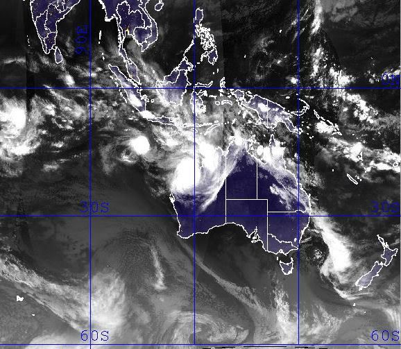
En we hebben George ten noorden van Australië
[ Bericht 24% gewijzigd door Frutsel op 04-03-2007 16:02:31 ]

[ Bericht 24% gewijzigd door Frutsel op 04-03-2007 16:02:31 ]
Bron: http://www.vwkweb.nl/cms/index.php?option=com_content&task=view&id=1181&Itemid=26quote:Orkaan ontstaat boven land
Ten zuiden van Darwin is de afgelopen dagen de tropische storm George ontstaan. George groeit de komende uren uit tot een orkaan. Het komt niet vaak voor dat een orkaan boven land ontstaat.
George is ontstaan uit een tropische depressie en heeft in de buitenwijken van Darwin meer dan 200 millimeter aan neerslag achtergelaten. Het systeem is westwaarts de zee op getrokken en boven het warme zeewater verder geactiveerd. Voorlopig is er nog geen bedreiging voor het kustgebied elders.
Indonesië krijgt mogelijk ook nog last van Tropical Storm Jacob..
Hebben ze nog niet genoeg modder en regen gehad de laatste tijd...
Hebben ze nog niet genoeg modder en regen gehad de laatste tijd...
Ja en wat dacht je van die 2 aardbevingen en die vliegtuigcrash? Indonesië is wel goed de lul de laatste tijd.quote:Op woensdag 7 maart 2007 08:35 schreef Frutsel het volgende:
Indonesië krijgt mogelijk ook nog last van Tropical Storm Jacob..
[afbeelding]
Hebben ze nog niet genoeg modder en regen gehad de laatste tijd...
Klopt... in het NWS topic over de Aardbeving had iemand het al bij gehouden Aarbeving op Sumatra: Zeker 70 dodenquote:Op woensdag 7 maart 2007 12:12 schreef Eveli het volgende:
[..]
Ja en wat dacht je van die 2 aardbevingen en die vliegtuigcrash? Indonesië is wel goed de lul de laatste tijd.

After crossing Australia’s Northern Territory and triggering floods, Cyclone George skimmed along the Australian coast, steadily gaining power. By the time the storm took a sharp turn towards shore and headed towards Port Hedland in northern Western Australia on March 8, 2007, the cyclone packed sustained winds of 200 kilometers per hour (127 miles per hour, 110 knots) with gusts to 250 km/hr (155 mph, 135 knots). The Moderate Resolution Imaging Spectroradiometer (MODIS) on NASA’s Terra satellite captured this image on March 8, at 10:55 a.m., local time (1:55 UTC). Though the storm lacks a distinct eye, the dense concentration of swirling clouds attests to the storm’s power.
De categorie 3-orkaan George is in het westen van Australië onverwacht aan land gekomen. De orkaan ging gepaard met windstoten tot 275 kilometer per uur.
Ondanks het nieuwe Australische waarschuwingssysteem is George woensdag 90 graden van koers gewijzigd, om daarna de kust bij Port Hedland te rammen. Het oog trok rakelings langs de stad. In het woestijnrijke binnenland verloor de orkaan snel aan kracht. George was eerder boven land ontstaan uit een tropische depressie ten zuiden van Darwin.
vwk
Christmas Is asylum seekers brace for cyclone's effects
Immigration officials have an evacuation plan in place for the 83 asylum seekers on Christmas Island, off the coast of Western Australia.
Cyclone Jacob, a category three storm, is 280 kilometres south of the island.
Christmas Island is on yellow alert, with people advised to stay indoors.
Shire president Gordon Thompson says conditions are deteriorating and the island is bracing for 90 kilometre per hour winds.
"The sea's very rough, big swells coming from the north-west," he said.
The cyclone is expected to move away from the island tonight but a spokeswoman for the Immigration Minister, Kevin Andrews, has confirmed an evacuation plan as been devised in case the cyclone changes course.
She says the asylum seekers would remain on the island but would be relocated to a safer building, believed to be the island's recreation centre.
However, an official at the island's detention centre says there are no cyclone-proof buildings on the island and an evacuation to the mainland may be more appropriate.
Christmas Island
[ Bericht 5% gewijzigd door #ANONIEM op 08-03-2007 21:48:47 ]
Immigration officials have an evacuation plan in place for the 83 asylum seekers on Christmas Island, off the coast of Western Australia.
Cyclone Jacob, a category three storm, is 280 kilometres south of the island.
Christmas Island is on yellow alert, with people advised to stay indoors.
Shire president Gordon Thompson says conditions are deteriorating and the island is bracing for 90 kilometre per hour winds.
"The sea's very rough, big swells coming from the north-west," he said.
The cyclone is expected to move away from the island tonight but a spokeswoman for the Immigration Minister, Kevin Andrews, has confirmed an evacuation plan as been devised in case the cyclone changes course.
She says the asylum seekers would remain on the island but would be relocated to a safer building, believed to be the island's recreation centre.
However, an official at the island's detention centre says there are no cyclone-proof buildings on the island and an evacuation to the mainland may be more appropriate.
Christmas Island

[ Bericht 5% gewijzigd door #ANONIEM op 08-03-2007 21:48:47 ]

Though Cyclone George was a very weak storm when it passed over Australia’s Northern Territory on March 1 and March 2, 2007, it brought widespread rain and high tides to the region. The rain and tides triggered floods along the coast and in river systems, which are shown in the top image, captured by the Moderate Resolution Imaging Spectroradiometer (MODIS) on NASA’s Terra satellite on March 8. The lower image, taken on February 15, 2007, shows the area before the storm came ashore. In these images, made with visible and infrared light, water is black or dark blue. Most striking in the March 8 image is the dark pools of water along the coast and coastal inlets. The wetlands that jut in from the northern shore have expanded into wide, triangular rivers. To the southwest, the Daly River and nearby wetlands are also flooded.
Signs of flooding are also visible in the Indian Ocean. Though sunlight reflecting off the water makes the color hard to distinguish, the water near shore is blue, not black as it was in February. When flood water drains into the ocean, it carries sediment from the run-off. The sediment scatters light, lending the water the blue color seen here. Clouds in this type of image are pale blue and white
At least three people are feared dead and up to 20 injured, after a powerful cyclone hit north-west Australia.
Cyclone George packed winds of up to 280km/h (170 mph), damaging homes and disrupting power in the remote town of Port Hedland.
A local mining company closed its iron ore operations, and some offshore oil production was also suspended.
Officials say the cyclone is the worst storm to hit the region since Cyclone Vance in 1999.
Cyclone George, which forecasters said may have been a maximum level five storm as it crossed the coast, hit a mine construction camp owned by Fortescue Metals Group, based about 100km (62 miles) south of Port Hedland.
It destroyed many temporary housing units at the camp, where workers were staying while building a railway
At least one person is known to have died, but Western Australia Premier Alan Carpenter said there were unconfirmed reports that three people had been killed at the site.
An emergency team has recently been able to reach the camp and evacuate the injured, according to the metals company, but rescue attempts are still being hampered by continuing strong winds.
Storm damage
The storm also tore off roofs, felled trees and cut power lines to at least three towns in the area, according to emergency officials.
"We had our patio start to lift, we had fences being pushed over, trees being snapped, everything flying around," Port Hedland resident Steve Fitzgibbon told a local radio programme.
Cyclones are a regular feature in northern Australia during the summer months.
Cyclone Tracy killed 65 people in the northern city of Darwin in 1974.
Jacob heeft ook een rare bocht gemaakt en doet ook nog even Noord-West Australië aan... waar George net heeft huisgehouden

Madagascar krijgt mogelijk ook nog een nieuwe storm voor de kiezen
http://cimss.ssec.wisc.ed(...)/images/xxwvmet5.GIF
http://cimss.ssec.wisc.ed(...)t5wv/met5wvjava.html
http://cimss.ssec.wisc.ed(...)/images/xxwvmet5.GIF
http://cimss.ssec.wisc.ed(...)t5wv/met5wvjava.html
bron:quote:Western Australia's Pilbara is bracing itself for the arrival of another tropical cyclone at noon today AWDT although emergency authorities no longer expect it to cause much damage.
After the destruction of cyclone George on Thursday, towns along the Pilbara coast have been anxiously watching the approach of tropical cyclone Jacob.
Jacob has been downgraded to a category one system and it is not expected to intensify before crossing the coast between Karratha and Port Hedland later today.
There had been early fears cyclone Jacob could intensify into a category four, but those concerns eased as the cyclone progressively weakened over the weekend as it tracked toward the coast.


CAMP SPRINGS, Maryland, - On the heels of El Niño, its opposite, the cooling weather pattern in the east-central equatorial Pacific known as La Niña is expected to arrive soon, according to government forecasters. La Niña conditions in the Pacific typically mean a greater than normal number of Atlantic hurricanes.
Photo: Dolphins play in the eastern tropical Pacific Ocean. (Photo courtesy NOAA)
In a weekly update, scientists at the NOAA Climate Prediction Center said that as the 2006-2007 El Niño has faded, surface and subsurface ocean temperatures have rapidly decreased.
Recently, cooler than normal water temperatures have developed at the surface in the east-central equatorial Pacific, indicating a possible transition to La Niña conditions.
La Niña conditions occur when ocean surface temperatures in the central and east-central equatorial Pacific become cooler than normal.
These changes affect tropical rainfall patterns and atmospheric winds over the Pacific Ocean, which influence the patterns of rainfall and temperatures in many areas worldwide.
Typically, across the United States during the spring and summer months, La Niña conditions do not significantly impact overall inland temperature and precipitation patterns,but La Niña episodes often do have an effect on Atlantic and Pacific hurricane activity.
"Although other scientific factors affect the frequency of hurricanes, there tends to be a greater than normal number of Atlantic hurricanes and fewer than normal number of eastern Pacific hurricanes during La Niña events," said NOAA Administrator Conrad Lautenbacher.
"During the winter, usual La Niña impacts include drier and warmer than average conditions over the southern United States," he said.
"NOAA's ability to detect and monitor the formation, duration and strength of El Niño and La Niña events is enhanced by continuous improvements in satellite and buoy observations in the equatorial Pacific," Lautenbacher explained.
The observing systems currently at work include the TAO/TRITON moored and Argo drift buoys, as well as NOAA's polar orbiting satellites.
"La Niña events sometimes follow on the heels of El Niño conditions," said Vernon Kousky, research meteorologist at the NOAA Climate Prediction Center. "It is a naturally occurring phenomenon that can last up to three years."
"While the status of El Niño/La Niña is of vital importance to our seasonal forecasts, it is but one measure we use when making actual temperature and precipitation forecasts," said Kousky.
La Niña episodes tend to develop during the four months from March through June, reach peak intensity during the December to February period, and then weaken during the following March to May period.
"The last lengthy La Niña event was 1998-2001, which contributed to serious drought conditions in many sections of the western United States," said Douglas Lecomte, drought specialist at the NOAA Climate Prediction Center.
In addition, atmospheric scientists have uncovered fresh evidence to support the controversial theory that global warming has contributed to the emergence of stronger hurricanes in the Atlantic Ocean.
Scientists at the University of Wisconsin-Madison and NOAA's National Climatic Data Center report that all the physical variables that converge to form hurricanes - wind speeds, wind directions and temperatures - feed off each other in ways that only make conditions more ripe for a storm.
The unsettling trend is confined to the Atlantic and does not hold up in any of the world's other oceans, researchers have also found.
James Kossin, a research scientist at UW-Madison's Cooperative Institute for Meteorological Satellite Studies, says the pattern emerged from a new dataset that correlates a variety of different satellite data over 22 years from 1983 to 2005.
"While we can see a correlation between global warming and hurricane strength, we still need to understand exactly why the Atlantic is reacting to warmer temperatures in this way, and that is much more difficult to do," says Kossin. "We need to be creating models and simulations to understand what is really happening here."
NOAA will issue the U.S. Spring Outlook on March 15, and its Atlantic Hurricane Season Outlook in May. Both outlooks will reflect the most current La Niña forecast.

Krijgt Madagascar nu twee stormen tegelijk voor de kiezen?
Formation
Indlala
==============
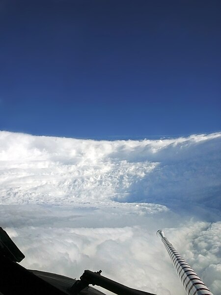
en nog even een prachtige foto van de "eyewall" van Hurricane Katrina
Formation

Indlala
==============
en nog even een prachtige foto van de "eyewall" van Hurricane Katrina
Hier trouwens een prachtige 'gif' van beide stormen voor de kust van Madagascar.. .jammer dat ik hem hier niet kan laten zien...
http://cimss.ssec.wisc.ed(...)an/visirjava19S.html
http://cimss.ssec.wisc.ed(...)an/visirjava19S.html
Mooi om te zien.quote:Op dinsdag 13 maart 2007 23:22 schreef Frutsel het volgende:
Hier trouwens een prachtige 'gif' van beide stormen voor de kust van Madagascar.. .jammer dat ik hem hier niet kan laten zien...
http://cimss.ssec.wisc.ed(...)an/visirjava19S.html
Alles kanquote:Op dinsdag 13 maart 2007 23:22 schreef Frutsel het volgende:
Hier trouwens een prachtige 'gif' van beide stormen voor de kust van Madagascar.. .jammer dat ik hem hier niet kan laten zien...
http://cimss.ssec.wisc.ed(...)an/visirjava19S.html

Doe mee met het voorspellen van het weer!
Weekvoorspelling | Week 12 (invullen tot 16-03 - 11:59)
Maandvoorspelling Maart (Inzendingen gesloten)
Jaarvoorspelling 2025 / 2026
Weekvoorspelling | Week 12 (invullen tot 16-03 - 11:59)
Maandvoorspelling Maart (Inzendingen gesloten)
Jaarvoorspelling 2025 / 2026
Slachtoffer orkaan Rita nu pas gevonden
In een huis in de Amerikaanse plaats Beaumont zijn na anderhalf jaar de resten van een slachtoffer van de orkaan Rita gevonden.
De man lag gewoon in zijn bed. Zijn huis was vrijwel niet beschadigd, maar er was sinds de verwoestende orkaan niemand binnen geweest omdat er twee grote bomen voor de ingang lagen.
De 51-jarige Texaan leefde een kluizenaarsbestaan. Buren namen aan dat de man was gevlucht voor Rita en de hulpdiensten controleerden alleen woningen die schade hadden opgelopen door de orkaan.
Cycloon Indlala op weg naar Madagaskar
De krachtige cycloon Indlala ligt momenteel voor de noordoostkust van Madagaskar. De windsnelheden komen overeen met een orkaan van de 2e categorie op de schaal van Saffir-Simpson. De cycloon trekt nu over water met een temperatuur van ruim 27 graden, en zal naar verwachting nog wat verder uitdiepen. Morgen kan het schiereiland Masoala bereikt worden.
De krachtige cycloon Indlala ligt momenteel voor de noordoostkust van Madagaskar. De windsnelheden komen overeen met een orkaan van de 2e categorie op de schaal van Saffir-Simpson. De cycloon trekt nu over water met een temperatuur van ruim 27 graden, en zal naar verwachting nog wat verder uitdiepen. Morgen kan het schiereiland Masoala bereikt worden.
Hij blijft daar gewoon bij, maar kan wel even kijken wat ik kan doenquote:Op woensdag 14 maart 2007 08:13 schreef Frutsel het volgende:
Kewl Speedy!
Houdt hij die ook automatisch up-to-date of is en blijft dit die ene momentopname?
Hmmz nee dus, niks aan te doen
Doe mee met het voorspellen van het weer!
Weekvoorspelling | Week 12 (invullen tot 16-03 - 11:59)
Maandvoorspelling Maart (Inzendingen gesloten)
Jaarvoorspelling 2025 / 2026
Weekvoorspelling | Week 12 (invullen tot 16-03 - 11:59)
Maandvoorspelling Maart (Inzendingen gesloten)
Jaarvoorspelling 2025 / 2026
Warmer klimaat zorgt nog niet voor meer cyclonen
Er zijn geen aanwijzingen dat de intensiteit van tropische cyclonen wereldwijd toeneemt. Alleen boven de Atlantische Oceaan is een lichte stijging zichtbaar, maar daar ontstaan maar 15 procent van alle cyclonen. Daarom staat niet vast dat er een verband is tussen opwarmend zeewater en zwaardere cyclonen. Amerikaanse onderzoekers, aangevoerd door James Kossin, meldden dit in Geophysical Research Letters.
Trends in cycloon-intensiteit kunnen worden afgeleid uit infrarood-opnames die satellieten sinds de jaren zeventig maken, maar de kwaliteit van de opnames veranderden sterk. Kossin schoonde oude analyses op en zag dat de intensiteit van cyclonen boven de Indische en Grote Oceaan is overschat. Het IPCC maakte in zijn laatste klimaatrapport al een voorbehoud.
Klimaatnieuws
George and Jacob flood North West Australia
In the course of a week, the northern coast of Western Australia went from dry desert to riverine landscape under the onslaught of two successive tropical cyclones. Powerful Cyclone George roared ashore on March 8, 2007, with winds gusting up to 275 kilometers per hour (170 miles per hour). The storm caused extensive damage, including three deaths, reported the Australia Broadcasting Corporation News. The much weaker Cyclone Jacob came ashore just east of George’s landing point on March 12. The top image, captured on March 13, by the Moderate Resolution Imaging Spectroradiometer (MODIS) on NASA’s Terra satellite, shows the cumulative impact of the two storms on the DeGrey River basin.
The DeGrey River flows west through Western Australia before it turns north to empty into the Indian Ocean at Poissonnier Point east of the city of Port Hedland, the city most severely damaged by Cyclone George. On March 6, before both storms struck, the river was barely distinguishable in MODIS imagery. One week later, the river and its many tributaries cut a tangle of blue across the landscape. The heavy rain brought by the storms has also prompted plant growth. The land has gone from desert pink—the color of bare or sparsely vegetated land in this type of image—to the bright green of plant-covered land. The images were made with both infrared and visible light to highlight the presence of water on the ground. In this type of image, water is black or dark blue, where tainted with sediment, and clouds are pale blue and white.

Cyclone Indlala came ashore on the island of Madagascar on March 15, 2007, as a Category 3 storm, according to data provided by the Joint Typhoon Warning Center. The storm was the country’s sixth hit of the 2006-2007 storm season. This image from the Moderate Resolution Imaging Spectroradiometer (MODIS) on NASA’s Terra satellite shows Indlala draped over the northern part of the island. Bands of swirling clouds spiral around the eye of the storm.
According to Reuters AlertNet news service, Madagascar’s emergency response resources were taxed to their limit in early March 2007 as a result of extensive flooding in the North, drought and food shortages in the South, and three previous hits from cyclones in the preceding few months: Bondo in December 2006, Clovis in January 2007, and Gamede in February. The arrival of Indlala interrupted emergency relief efforts and worsened an already difficult situation.
Forecasters: Active Atlantic Season
MIAMI (Reuters) - The Atlantic hurricane season will be exceptionally active this year, according to a British forecasting group, raising the possibility that killer storms like Hurricane Katrina could again threaten the United States.
London-based forecaster Tropical Storm Risk on Tuesday said the six-month season, which begins on June 1, was expected to bring 17 tropical storms, of which nine will strengthen into hurricanes with winds of at least 74 miles per hour.
Four of those are expected to become more destructive "intense" hurricanes, TSR said.
The long-term average for the Atlantic is for 10 storms to form during the hurricane season and for six of those to reach hurricane strength.
The United States emerged unscathed from the 2006 season after it spawned a below-average nine storms, of which five became hurricanes. Experts had universally -- and erroneously -- predicted 2006 would be a busy year for Atlantic storms.
None of the hurricanes hit the United States, bringing welcome relief to beleaguered residents of the U.S. Gulf Coast, where Katrina killed 1,500 people, swamped New Orleans and caused about $80 billion in damage the year before.
But TSR said current and projected climate signals indicate that Atlantic basin and U.S. landfalling hurricane activity will be 75 percent above the 1950-2006 average in 2007.
TSR had predicted in December that Atlantic basin and U.S. landfalling hurricane activity would be just 60 percent above average this year. It raised the projected activity level because of the sudden dissipation in February of last year's El Nino weather phenomenon
An unusual warming of the eastern Pacific waters, El Nino events tend to suppress Atlantic storm activity.
Other experts, including hurricane forecast pioneer Dr. William Gray and his team at Colorado State University, have also warned that the 2007 hurricane season is likely to be busier-than-average.
The relative calm of last year's hurricane season, which forecasters had mistakenly predicted would be busy, came on the heels of a record 28 storms and 15 hurricanes in 2005 and only a slightly less furious season in 2004.(Reuters)
Veel doden op Madagaskar door cycloon
ANTANANARIVO - De cycloon Indlala die vorige week een spoor van vernielingen trok over het eiland Madagaskar heeft tientallen levens geëist. Tienduizenden mensen in het noorden van het land zijn verdreven door het natuurgeweld, meldde de regeringsfunctionaris verantwoordelijk voor rampensbestrijding vrijdag.
„Ik heb nog nooit zo veel schade gezien”, aldus Jacky Randimbiarison. Twee mensen zouden nog worden vermist. In het district Ambanja stortte een hele berg in op twee dorpen. De nederzettingen zijn begraven onder duizenden tonnen steen. Twintig mensen onder wie zes kinderen kwamen om in een school.
Het Internationale Rode Kruis heeft een noodoproep gedaan voor bijna 500.000 euro aan giften. Het geld is nodig voor het lenigen van de eerste nood. Honderdduizenden mensen zouden getroffen zijn door het natuurgeweld.


Tropical Cyclone Kara
Tropical Cyclone Kara was poised just offshore of the Pilbara coast of Western Australia on March 27, 2007. Kara was not a particularly severe storm, but was hitting in the same area that Cyclone George, a much more powerful storm, and Cyclone Jacob, a smaller Category 2 storm similar to Cyclone Kara, had struck two weeks earlier.
This photo-like image was acquired by the Moderate Resolution Imaging Spectroradiometer (MODIS) on the Terra satellite on March 27, 2007, at 10:25 a.m. local time (02:25 UTC). The storm was a tropical cyclone with a circular shape and distinct eye at its center. According to the University of Hawaii’s Tropical Storm Information Center, Cyclone Kara had sustained winds of 145 kilometers per hour (90 miles per hour) at the time this image was acquired.

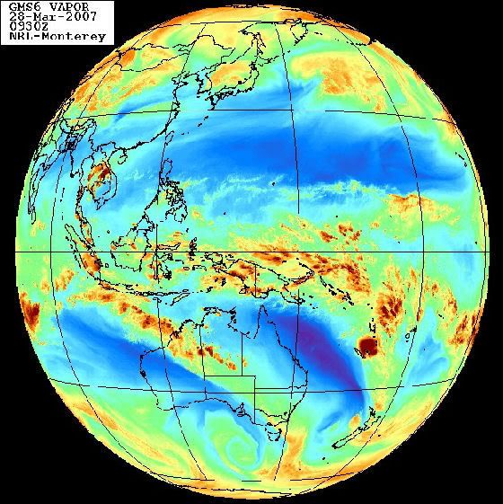
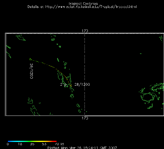
Waar ligt dat systeem momenteel?quote:Op woensdag 28 maart 2007 09:16 schreef Frutsel het volgende:
21P is inmiddels 'geupgrade' naar BECKY
[afbeelding]
Jep, op zo'n beetje dezelfde lokatie als waar van de week die aardbeving was.quote:Op woensdag 28 maart 2007 12:35 schreef highway101 het volgende:
Dat is volgens mij bij Vanuatu en New Caledonia, een eind ten oosten van Australië
Toeval? DE ---> TRU