WKN Weer, Klimaat en Natuurrampen
Lees alles over het onstuimige weer op onze planeet, volg orkanen en tornado's, zie hoe vulkanen uitbarsten en hoe Moeder Aarde beeft bij een aardbeving. Alles over de verwoestende kracht van onze planeet en tal van andere natuurverschijnselen.


Voorgaande topics
Topicreeks: Aardbevingen
Samenvatting
Een aardbeving is een trilling of schokkende beweging van de aardkorst. Aardbevingen vinden plaats als er in de aardkorst plotseling veel energie vrijkomt. De energie plant zich dan in een golfbeweging vanuit het centrum naar de omgeving voort. Het denkbeeldige punt waar de beving ontstaat, het zwaartepunt van de energiedichtheid, heet het hypocentrum. Het punt aan het aardoppervlak daar loodrecht boven wordt het epicentrum genoemd. Een lijn van gelijke bevingintensiteit rond een epicentrum heet een isoseist. Seismologie is de wetenschap van aardbevingen.
De meeste aardbevingen komen voor in de aardkorst tot op een diepte van ongeveer 30 kilometer. Er komen echter ook bevingen voor op dieptes tot ongeveer 700 kilometer. De meeste aardbevingen komen voor rondom de Grote Oceaan, in het Middellandse Zeegebied, in de Himalaya en Indonesi�. Ook midden in oceanen komen bevingen voor. Aardbevingen die ontstaan onder de zeespiegel worden, minder correct, ook wel zeebevingen genoemd; een vloedgolf of tsunami kan dan het gevolg zijn.
Veel aardbevingen hangen samen met de langzame interne bewegingen van de aardkorst. Op grote schaal kan het de aardschollen betreffen, die langzaam ten opzichte van elkaar bewegen (platentektoniek). Op kleinere schaal vindt er ook binnen de platen deformatie plaats.
Door deze relatieve beweging wordt spanning opgebouwd in de korst. Als de spanning hoog genoeg is kan er een schoksgewijze beweging van het materiaal aan weerszijden van een breuk in de korst optreden: de aardbeving. Hierbij wordt (een deel van) de opgebouwde spanning ontladen. Naschokken zijn kleinere bevingen die binnen enkele uren na de eerste beving voelbaar zijn. Deze zijn vaak het gevolg van spanningsontlading op andere, nabijgelegen delen van dezelfde breuk of op andere nabije breuken. Dit type aardbevingen komt binnen platen voor tot een diepte van enkele tientallen kilometers en aan plaatranden ook tot op grotere diepte.
Aardbevingen op dieptes van enkele honderden kilometers worden vaak toegeschreven aan andere mechanismen. Ten eerste kunnen deze worden veroorzaakt in een subducerende plaat door de overgang van mineralen van een fase naar de andere (zie convectie in de aarde). Wanneer de oude fase metastabiel was, kan de overgang naar de nieuwe fase zeer plotseling zijn. Op een vergelijkbare wijze kan het plotseling loslaten van water uit waterhoudende mineralen in de subducerende plaat een aardbeving veroorzaken.
Kleine aardbevingen zijn het gevolg van vulkanische activiteit (vulkanische aardbevingen) of ontstaan door instorting van holtes in kalksteenformaties of mijnen (instortingsbevingen). Mogelijke andere oorzaken zijn ondergrondse kernproeven en meteorietinslagen.
Menselijk ingrijpen kan bevingen veroorzaken. De bodemdaling door de winning van aardgas brengt aardschokken teweeg. Dit fenomeen doet zich onder meer voor in de provincie Groningen bij het dorp Loppersum.
Hoe ontstaan ze?
Een aardbeving is een trilling of schokkende beweging van de aardkorst. Aardbevingen worden veroorzaakt als er ergens in de aardkorst plotseling veel energie vrijkomt. Dit kan door bijvoorbeeld het langs elkaar heen schuiven van de aardschollen. (Platentektoniek genoemd) Of doordat aardschollen onder/over elkaar schuiven met brute kracht. De wrijving/spanning veroorzaakt dan een breuk/aardbeving.
Breuklijnen, Aardschollen
Op onderstaand plaatje kun je zien waar ter wereld de 'aardschollen' liggen. Op de grens van twee schollen komen dan ook de meeste aardbevingen ter wereld voor.

E�n van de bekendste breuken ter wereld is de San Andreas Faultline (=breuklijn) in Californie. Deze is ontstaan doordat de Pacifische Plaat langzaam langs/onder de Noord Amerikaanse plaat schuift.

Hoe worden ze gemeten?
Aardbevingen komen meestal voor op een diepte tussen de 0 en 30 km. Maar ze kunnen ook op 600 km diepte voorkomen. Het punt aan de aardkorst oppervlakte dat loodrecht boven de plek van de beving staat noemen we het "epicentrum" De bevingen worden in kaart gebracht mbv de "Schaal van Richter (Vernoemd naar de geoloog Francis Richter uit 1935).
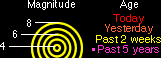
De Richter schaal wordt gebruikt om de kracht van een aardbeving aan te geven. Het gaat daarbij om de hoeveelheid energie de vrijkomt tijdens de aardbeving. Op de Richter schaal wordt de kracht aangegeven met een getal. De Schaal van Richter is logaritmisch, dat wil zeggen dat de kracht van de aardbeving 10 keer zo groot is als het Richter getal met 1 toeneemt. Een aardbeving met kracht 6 is dus 10 keer zo zwaar als een aardbeving met kracht 5. Meer info over de richterschaal vind je o.a. in onderstaande links.
De vijftien sterkste aardbevingen sinds 1900 zijn:

| 1 2 3 4 5 6 7 8 9 10 11 12 13 14 15 16 | Locatie Datum Kracht 1. Chile 22-mei-1960 9.5 2. Prince William Sound, Alaska 28-mrt-1964 9.2 3. Off W. Coast of N. Sumatra 26-dec-2004 9.1 4. Kamchatka 04-nov-1952 9.0 5. Offshore Maule, Chili 27-feb-2010 8.8 6. Off the Coast of Ecuador 31-jan-1906 8.8 7. Rat Islands, Alaska 04-feb-1965 8.7 8. Northern Sumatra, Indonesia 28-maa-2005 8.6 9. Andreanof Islands, Alaska 09-maa-1957 8.6 10. Assam - Tibet 15-aug-1950 8.6 11. Southern Sumatra, Indonesia 12-sep-2007 8.5 12. Kuril Islands 13-okt-1963 8.5 13. Banda Sea, Indonesia 01-feb-1938 8.5 14. Kamchatka 03-feb-1923 8.5 15. Chili-Argentinian border 11-nov-1922 8.5 |
De aardbeving die de meeste slachtoffers kostte was overigens veel lichter. In 1976 deed zich in China een aardbeving voor met een kracht van 8.0. Omdat het een zeer dicht bevolkt gebied was waren er ongeveer 250.000 doden te betreuren. Op 26 december 2004 vond een aardbeving plaats voor de kust van het Indonesische eiland Sumatra. Deze zeebeving had een kracht van 9.0 op de schaal van Richter. Er vielen echter slachtoffers in de hele regio Zuid-Oost Azi� (India, Sri Lanka, Thailand, Indonesi� zelf) als gevolg van de tsunami (vloedgolf) die volgde op de zeebeving. Waarschijnlijk zijn daar ook 200.000 slachtoffers gevallen. Zeer recent, in januari 2010, zorgde een beving van 7.0 voor meer dan 220.000 slachtoffers in Haïti. In mei 2008 vielen er in de Chinese provincie Sichuan ruim 65.000 doden bij een beving van 8.0. In 2003 vielen bij een aardbeving in Iran meer dan 40.000 doden bij een beving in Bam van 6.2, terwijl in 1999 ruim 44.000 mensen de dood vonden bij een beving in Turkije.
Aardbevingen? Ook in Nederland?
Ook in Nederland komen aardbevingen voor. In het zuidoosten worden elk jaar kleine aardbevingen gemeten met een kracht van 2 tot 3 op de schaal van Richter. Soms zijn er sterkere aardbevingen, zoals op 13 april 1992 in de buurt van Roermond met een kracht van 5.8 en in 2002 iets ten oosten van Roermond in Duitsland met een kracht van 4.9.
In Noord-Nederland komen, vooral in Groningen en Drenthe, lichte aardbevingen voor. Die worden naar alle waarschijnlijkheid veroorzaakt door de gaswinning uit de bodem, waardoor de aardbodem zakt. Op 24 oktober 2003 was er in de omgeving van Loppersum een lichte aardbeving met een kracht van 3.0. Het verslag van het KNMI over deze aardbeving vind je hier. In diezelfde omgeving vond ook op 22 september 2003 een (lichtere) aardbeving plaats, kracht 2.3.
Hoeveel aardbevingen vinden er plaats?
Het gemiddeld aantal bevingen per jaar met de bijbehorende magnitude (kracht) zijn:
-3000 met magnitude 5.0-5.9
-100 met magnitude 6.0-6.9
-20 met magnitude 7.0-7.9
-2 met magnitude 8.0 of meer
• Dit plaatje geeft weer waar er aardbevingen zijn geweest tussen 1963 en 1998.
• Dit plaatje geeft weer waar er aardbevingen zijn geweest tussen 1978 en 1987.
Tsunami's - een gevolg van een zeebeving
Sinds de catastrofale zeebeving op 2e kerstdag 2004 is het woord 'tsunami' niet meer weg te denken uit de woordenboeken. Wat is nou een Tsunami?
Alle gebeurtenissen waarmee een grote hoeveelheid water in korte tijd wordt verplaatst kunnen een tsunami veroorzaken. Vloedgolven kunnen veroorzaakt worden door een zeebeving, een aardbeving waarvan het epicentrum onder de zeespiegel ligt, door een meteoriet, of door een vulkanische uitbarsting onder zee of vlak aan zee, vooral als daarbij door een grote aardverschuiving veel gesteente de zee in schuift. Ook bij plotseling afkalven van een gletsjer of ijsberg kan een vloedgolf ontstaan. Ook kan het zo zijn dat er grote stukken land of gebergte het water invallen. Hierdoor ontstaan vaak kleinere tsunami's omdat er minder water wordt verplaatst.
De meeste tsunami's komen voor rondom de Grote Oceaan, omdat langs de randen daarvan door de platentektoniek de meeste aardbevingen plaatsvinden.

Verloop van de tsunami in 2004
Door de verplaatsing van de zeebodem, vooral als deze kilometers diep plaatsvindt, wordt een enorme kolom water opgetild. Aan het wateroppervlak is daarvan weinig te zien, er ontstaat een golf van misschien een hoogte van enkele decimeters, met een enorme golflengte van 100 tot 400 kilometer. Door deze grote golflengte zijn er op volle zee maar enkele pieken en dalen merkbaar; op een schip zal de tsunami ongemerkt voorbij gaan. Een golf die door de wind wordt veroorzaakt kan weliswaar een veel grotere hoogte bereiken, tot 10 meter, bij een golflengte van 200 meter, maar de energie die in de tsunami is opgeslagen is veel groter. De waterbeweging vindt bij een tsunami plaats tot op de zeebodem, terwijl een golf door de wind slechts aan het oppervlak van de zee te merken is. Een normale golf bereikt een snelheid tot 40 km/uur, maar een tsunami kan zich met een veel hogere snelheid verplaatsen. De periode van de tsunami (het tijdsverloop tussen twee toppen) bedraagt een kwartier tot een uur.
Wat is GEE?
GEE betekent Global Earthquake Explorer. Het is een programma voor je desktop waar je live aardbevingen en data mee ontvangt.
• Developer page
• Download GEE
• Screenshots
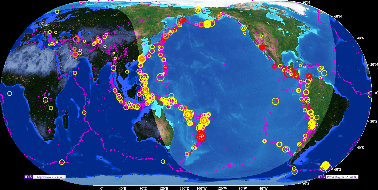
Overzichten Real-time aardbevingen
Europa
Rest van de wereld
Naslagwerken / Informatie / Nuttige Links / Sites
Aardbevingen
• Nederlandse Aardbevingsite
• US Geological Survey Website
• WikiPedia Aardbeving
• Natuurrampen pagina
• Europese (realtime) Aardbevingen
• Earthquake - Report
• Aardbevingsdossier Kennislink
• Aardbevingen, overzicht, hoe en waarom
Tsunami's
• WikiPedia Tsunami
• Tsunamidossier Kennislink
Deze op is te vinden in de FOK!Wiki:
[*] Fok!Wiki OP/Aardbevingen
| Wordfeud: marcel-o |plug.dj/uptempo |<-- draai zelf je platen
k had de laatste 
laatste posts
[ Bericht 34% gewijzigd door Frutsel op 15-09-2011 18:59:20 ]
laatste posts
quote:Op donderdag 15 september 2011 16:58 schreef Frutsel het volgende:
27 februari 2010 : 8.8 aardbeving Chili
189 dagen daarna
4 september 2010 : Zware aardbeving NieuwZeeland
188 dagen daarna
11 maart 2011: 9.0 aardbeving Japan
187-189 dagen daarna komen we op 15-16-17 september 2011....
als je deze vier bevingen bekijkt zou je denken dat nu de 4e hoek van het vierkant aan de beurt is... dus San Francisco - LA
quote:Op donderdag 15 september 2011 17:31 schreef marcel-o het volgende:
hier staat ook wat leuks:
http://www.earthwatcher.nl/universum/6174.html
[ Bericht 34% gewijzigd door Frutsel op 15-09-2011 18:59:20 ]
| Wordfeud: marcel-o |plug.dj/uptempo |<-- draai zelf je platen
Drukke dag vandaag... 6.0 bij Nieuw Zeeland, 6.2 bij Japan en 7.2 bij Fiji. Vooral die eerste en die laatste zitten dicht bij elkaar. De eerste op de coordinaten 35.430S 177.877W, de laatste een stukje noordelijker op 21.596S 179.270W
6.6 net bij Japan.Gaat steeds beter daar... NOT 
http://earthquake.usgs.gov/earthquakes/recenteqsww/Quakes/pt11259000.phpquote:NewEarthquake Earthquakes Tsunamis
Preliminary: 6.6 earthquake, Near East Coast of Honshu, Japan. On 2011/09/16 19:26:44 UTC (9m ago, depth 41km). http://j.mp/o4Fo9Z
10 minutes ago
I give myself very good advice
But I very seldom follow it
That explains the trouble that I'm always in
But I very seldom follow it
That explains the trouble that I'm always in
Zou der nog een klapper komen?
Doe mee met het voorspellen van het weer!
Weekvoorspelling | Week 12 (invullen tot 16-03 - 11:59)
Maandvoorspelling Maart (Inzendingen gesloten)
Jaarvoorspelling 2025 / 2026
Weekvoorspelling | Week 12 (invullen tot 16-03 - 11:59)
Maandvoorspelling Maart (Inzendingen gesloten)
Jaarvoorspelling 2025 / 2026
En nog een 6.2quote:
6.6 net bij Japan.Gaat steeds beter daar... NOT
[..]
http://earthquake.usgs.gov/earthquakes/recenteqsww/Quakes/pt11259000.php
http://earthquake.usgs.go(...)uakes/usc0005vyj.php
Da's de derde 6.0+ in die regio binnen twee dagen
6.2 36.289N 141.308E - 15 Sep 2011 08:00:07 UTC
6.6 40.288N 142.727E - 16 Sep 2011 19:26:42 UTC
6.2 40.221N 143.049E - 16 Sep 2011 21:08:05 UTC
En nu ook weer een 5,6.... gaat goed daar.quote:
[..]
En nog een 6.2
http://earthquake.usgs.go(...)uakes/usc0005vyj.php
Da's de derde 6.0+ in die regio binnen twee dagen
6.2 36.289N 141.308E - 15 Sep 2011 08:00:07 UTC
6.6 40.288N 142.727E - 16 Sep 2011 19:26:42 UTC
6.2 40.221N 143.049E - 16 Sep 2011 21:08:05 UTC
Dan hoop ik dat het geen voorschokken zijn voor nog een echte klapper. Naschokken van de 9.0 van 11 maart klinkt al een stuk beter...
Je vergeet er een paar...quote:
[..]
En nu ook weer een 5,6.... gaat goed daar.
6.6, 5.2, 5.5, 6.2, 5.6. In een tijdsbestek van twee uur en tien minuten. En alle vijf bij de oostkust van Honshu, Japan.
Niet alleen in Japan, ook India krijgt er van langs (14.40 onze tijd):
MAP 6.8 2011/09/18 12:40:48 27.730 88.082 20.7 SIKKIM, INDIA
MAP 6.8 2011/09/18 12:40:48 27.730 88.082 20.7 SIKKIM, INDIA
Út Ljouwert
Dodental stijgt daar 
quote:BREAKING NEWS:
Three people killed as British embassy compound wall collapses after earthquake in Nepali capital Kathmandu
quote:Deaths after quake in Nepal/India
A magnitude 6.8 earthquake shook India's Sikkim state on Sunday night, sending people running from their homes. The epicenter of the quake was about 40 miles from Gangtok, the state's capital, on the Nepalese border.
The Indian government has reported that eight people died in India and Nepal, at least three when a building in Kathmandu collapsed. The quake also created a number of mudslides on the outskirts of Gangtok, killing at least one man who was trapped inside his car.
Additionally, at least 100 people were injured, according to initial reports. The earthquake also temporarily disrupted telephone lines, and the rapid rate of cell phone use over-burdened mobile networks, according to The Hindustan Times.
The tremors were felt as far away as Delhi, about 900 miles to the west.
India sits on the Indian Plate, a tectonic plate that has been colliding with the Eurasia Plate for about 50 million years. The Indian Plate is slowly being wedged under Eurasia, pushing up the northern plate, causing it to lift. The tectonic movement created the Himalayan Mountain range, which straddles the collision point between India, Nepal, Tibet and China.
Because of the plates' movement, the Himalayas are growing taller every year.
Earthquakes in India aren't rare, but a 6.8 magnitude quake is significant. The most recent quake in the country occurred on Sept. 7, when a 4.2 magnitude quake hit Delhi, where just hours earlier a bomb blast killed 11 and injured dozens more outside the Delhi High Court.
Delhi is considered to be in Zone 4 of the Earthquake Hazard Map of India, and is therefore designated as being in the High Damage Risk Zone. There hasn't been a significant earthquake in the city's recent history, although it has experienced minor vibrations from quakes elsewhere in the country and in Pakistan.
Gangtok is also in Zone 4, and is nestled between two Zone 5 (highest risk) areas to the east and west.
On Sunday, there were also earthquakes reported in Virginia and New Zealand, although they were significantly less potent than the Sikkim quake.
A series of tremors in Virginia, ranging from magnitudes 1.9 to 2.1 on the Richter scale, are now considered to be aftershocks of the Aug. 23 earthquake that shook the East Coast of the United States, according to the U.S. Geological Survey. Meanwhile, a 4.1 magnitude quake hit North Queensland, New Zealand around 2:30 a.m. Sunday.
There have not been any reports of injuries or damages in either location.
Last Thursday, two significant earthquakes happened in Cuba and Japan, ranging from a 6.0 to a 6.2-magnitude respectively.
Are multiple earthquakes in the same day anything to worry about?
Considering that there are about 1.5 million earthquakes a year, not really. And that's just above magnitude 2.0. Below that, there are more millions.
Additionally, USGS claims that 134 earthquakes between the magnitudes 6 and 6.9 occur annually, the same magnitude as those that hit India, Cuba and Japan. Statistically, is it not unlikely that two would happened on the same day.
In the past week, there have been more than 250 earthquakes in Alaska alone, nearly 30 of which happened Sunday. In California and Nevada, there were nearly 400 quakes over the same period, the largest reaching around 4.0 magnitudes, according to USGS.
Yet, 2011 has seen its share of large-scale quakes. In March, a 9.0 earthquake hit Japan, causing enormous damage and a nuclear disaster at the Fukushima power plant. A month earthlier, a 6.3 magnitude earthquake in Christchurch, New Zealand killed nearly 200.
On Sept. 6, a 6.6 magnitude earthquake hit the Indonesian island of Sumatra, killing a 12-year-old boy who was lying in bed and a man who died of a heart attack as he fled his home.
Op de FP staat:
 Alleen een 4,6 en 4,8 in diezelfde regio.
Maar daar zie ik helemaal niks van op usgs staanquote:De beving werd gevolgd door minstens twee naschokken van 6,1 en 5,3

Al 36 doden na zware aardbeving in Himalaya
Bij de zware aardbeving gisteren in het noordoosten van India zijn ondertussen al 36 doden gevallen. De aardbeving was voelbaar tot in Nepal en Tibet en leidde tot grote stroomstoringen en paniek in het Himalayagebied. Ook in Tibet en de Britse ambassade in Nepal vielen doden te betreuren. De dodentol zal wellicht nog oplopen.
De beving met een kracht van 6,9 op de schaal van Richter was meer dan 1.000 kilometer verder voelbaar, tot in New Delhi in het westen en Bangladesh in het oosten. Minstens zestig personen raakten gewond door modderstromen, vallend puin en ingestorte gebouwen in Gangtok, de hoofdstad van de Indiase staat Sikkim in de Himalaya.
De elektriciteit in het gebied viel uit waardoor veel mensen in paniek de straat opvluchtten. Anderen sprongen uit de ramen van hun huizen. In het Nepalese parlement werd een debat over de begroting stopgezet terwijl parlementsleden het op een lopen zetten. (sps)
hln
NRC meldt die cijfers ook, maar ze kloppen volgens mij idd niet.quote:
Op de FP staat:
[..]
Maar daar zie ik helemaal niks van op usgs staan
26 people in India's Sikkim state were killed and more than 200 were injured
11 people were killed the neighboring Indian states of Bihar and West Bengal and more than 100 injuries
7 deaths confirmed in China and 22 injuries in southern Tibet
9 deaths confirmed in Nepal
Totaal meer dan 400 gewonden.
Verder zijn niet alle getroffen gebieden bereikt en zitten er nog mensen vast.
Mogelijk nu eindelijk de lang verwachtte uitbarsting bij de Cleveland vulkaan daar?quote:
Vanochtend al een 5.2 en een 5.4 bij Fox Islands, Aleutian Islands, Alaska, nu weer een 5.8.
Vulkaan Cleveland op weg naar flinke uitbarsting?

quote:Ground beneath Kanchenjunga slips south, alarm bells ring for Bengal
New Delhi, Sept. 18: A behemoth chunk of rock about 20km beneath the mountains around Kanchenjunga lurched southward today in the 6.9 magnitude earthquake that scientists say should stir the Bengal and Sikkim governments into a state of high alert.
The first and preliminary analysis of the mechanisms underlying the earthquake near the Sikkim-Nepal border suggests that the western edge of Sikkim had slipped southward relative to Nepal during the earthquake, geophysicists and seismologists said.
The first earthquake was followed by two smaller 4.8 and 4.6 magnitude earthquakes on the eastern side of the main event in a pattern that points to additional build-up of strain in subterranean rocks across Sikkim, three scientists tracking the events said.
“The movement of rock associated with the 6.9 event on the western side of Sikkim is likely to have caused a pile-up of strain towards its east leading to the two subsequent events," said Supriyo Mitra, a seismologist at the Indian Institute of Science Education and Research, Calcutta. “In a region where strain has accumulated for years, the 6.9 event was a trigger for the next two,” Mitra told The Telegraph.
Geophysicists say the two smaller earthquakes would not have released the enormous strain that has accumulated in the region. “The two (smaller) quakes were like peanuts,” said Vinod Gaur, a geophysicist at the Indian Institute of Astrophysics, Bangalore.
G.C Debnath, director of the Alipore meteorological centre, said: “The first tremor with an intensity of 6.9 on the Richter scale happened at 6.11pm, followed by a 5.7 intensity aftershock at 6.21pm. The third one happened at 6.43pm with 5.3 intensity, while the last one occurred at 7.24pm with intensity of 4.6 at Richter scale.”
“These are not aftershocks because they are not on the same fault as the first event,” said Mitra, the seismologist at the Indian Institute of Science Education and Research, who maintains four seismic monitoring stations in Sikkim.
Scientists say release of the accumulated strain in Sikkim could happen in months or years — and earthquakes cannot be predicted. “I think prudence dictates that Bengal and Sikkim should initiate action — at least across Sikkim and north Bengal — to scrutinise buildings such as schools and hospitals, where a large number of people assemble, for vulnerability and retrofitting using available engineering solutions,” said Gaur.
The Himalayan region marks the zone where India is slipping under Tibet at the rate of about 18mm per year. This tectonic plate movement leads to strain build-up, which is released when subterranean rocks along the slip zone reach their fracture points.
Scientists estimate that the amount of energy released during the 6.9 earthquake was equivalent to 340,000 tonnes of TNT, or about 22 times the energy released by the atomic bomb dropped on Hiroshima.
Geophysicists say earthquakes in the Himalayas are likely to cause significant shaking of structures built along the Gangetic plains across northern and eastern India. “The contrast between the soft sediments lying above the harder rock all along the Gangetic plains is likely to cause amplification of energy,” said Shyam Sunder Rai, a scientist at the National Geophysical Research Institute, Hyderabad.
“Whatever energy has been released by the earthquakes today does not rule out the possibility of an even bigger quake in other areas along the Himalayan region,” said Rai.
Gaur believes moderate earthquakes may mean that more are to come. “Moderate earthquakes in plate boundary environments such as the Himalayas therefore verily presage closeness of the region to a great rupture of magnitude 8 or so.”
The US Geological Survey said this region has experienced relatively moderate seismicity in the past with 18 earthquakes of magnitude 5 or larger over the past 35 years within 100km of the epicentre of today’s event. The largest of these was a magnitude 6.1 earthquake in November 1980 about 75km southeast.

en vulkanen opwekken 
Inorbit: zeg dat dan typluie triangeljosti
Beauregard: Een beetje FOK!ker laat het brood door z'n moeder smeren.
Ecosia
ek's 'n flash drive, jy's 'n floppy
Beauregard: Een beetje FOK!ker laat het brood door z'n moeder smeren.
Ecosia
ek's 'n flash drive, jy's 'n floppy
een voorbode voor guatamala? nog een paar schokken rond guatamala city...
Inorbit: zeg dat dan typluie triangeljosti
Beauregard: Een beetje FOK!ker laat het brood door z'n moeder smeren.
Ecosia
ek's 'n flash drive, jy's 'n floppy
Beauregard: Een beetje FOK!ker laat het brood door z'n moeder smeren.
Ecosia
ek's 'n flash drive, jy's 'n floppy
Aardbeving in India:
95 doden, 500 gewonden.
Aan ongeveer 100.000 gebouwen schade.
Aardbeving van gisteren in Guatemala:
3 doden en 50 gewonden.
Ook daar redelijk veel schade.
95 doden, 500 gewonden.
Aan ongeveer 100.000 gebouwen schade.
Aardbeving van gisteren in Guatemala:
3 doden en 50 gewonden.
Ook daar redelijk veel schade.

quote:Mega quakes occur more frequently when sun has fewer sunspots: researchers
The frequency of mega earthquakes increases during periods when the sun has fewer sunspots, a team of Japanese researchers has found.
The finding was made by a team led by Kiyofumi Yumoto, a researcher in space and earth electromagnetism at Kyushu University's Space Environment Research Center.
The March 11 Great East Japan Earthquake occurred when there were few sunspots. The latest research suggests that the sun's activity could influence movements beneath the earth's surface.
Sunspots gradually increase and decrease in number in a cycle of about 11 years, and cause changes in the earth's atmosphere. The research team investigated the possibility that they could also produce changes beneath the earth's surface, and compared data on the number of sunspots between 1963 and 2000 and the 327,625 earthquakes of magnitude 4 or more that occurred during this period.
The study found that 65 percent of the earthquakes with magnitudes between 4.0 and 4.9 occurred during the periods with the fewest sunspots (each lasting about two years). The figure was around the same for earthquakes with magnitudes between 5.0 and 7.9. However, the figure was higher for the 28 mega earthquakes with magnitudes in the 8.0-9.9 range, with 79 percent of them occurring during periods with the fewest sunspots.
When there are fewer sunspots, a phenomenon occurs in which solar winds, or streams of charged particles from the sun, get stronger an average of three to four times a month. Seventy percent of the earthquakes of magnitude 6.0 or stronger occurred at such times.
Solar winds that become stormy are known to be able to induce strong currents in power transmission lines, which can lead to major blackouts.
"The relationship between the sun and the activity of earthquakes is not clear, but we hope that this is a step in uncovering the mystery of quakes," Yumoto said.
The results of the group's research will be announced at a meeting of the Society of Geomagnitism and Earth, Planetary and Space Sciences, which opens in Kobe on Nov. 3.
Schokkende beelden paniek bij toeristen tijdens aardbeving in Washington Monument
Gezinnen met kinderen stormen van trap; gebouw trilt 2’; barsten in muur, puin valt naar beneden
Bekijk de beelden hieronder, vanaf 1'45" begint paniek
Vorig maand werd de Amerikaanse oostkust getroffen door een zware aardbeving. Ook Washington kreeg de volle laag en er brak paniek uit. Zeker bij de toeristen die zich op het moment van de forse aardschok in het Washington Monument bevonden. Zo'n 150 meter boven de begane grond sloeg de angst hen om het hart toen het erg smalle gebouw begon te trillen. Er vielen ook heel wat brokstukken uit de top van de toren en de wand van het Monument vertoont heel wat grote barsten. Meer dan een maand na de aardbeving is de populaire attractie nog altijd gesloten wegens herstellingswerken. De beelden van een bewakingscamera, te bekijken onder dit artikel, in het gebouw zijn (letterlijk en figuurlijk) schokkend.
Jonge gezinnen met kinderen rennen in paniek van de trappen met hun kinderen op hun arm. De smalle trap moet het benauwde gevoel nog vergroot hebben. Het trillen van het hoge gebouw duurt zo'n twee minuten. In de video van de bewakingscamera is te zien hoe de gids de toeristen naar beneden begeleidt: via de trap naar de nooduitgang. Vervolgens keerde ze terug naar boven om te controleren of alle bezoekers uit het gebouw waren.
170 meter hoog
Het Washington Monument is net geen 170 meter hoog en het was helemaal bovenaan dat de grootste schade werd opgemeten. Zeker omdat het gebouw enkele dagen later nog eens geteisterd werd door de extreme windkracht en overvloedige regen van orkaan Irene. Daarbij ontstonden nog meer barsten in de stenen muur en zelfs wat wateroverlast.
800.000 bezoekers per jaar
Het Washington Monument is één van de belangrijkste toeristische attracties in de Amerikaanse hoofdstad. Het werd opgericht voor George Washington, de eerste Amerikaanse president. Het is de hoogste obelisk ooit gebouwd en is opgetrokken uit marmer, graniet en zandsteen. Het monument maakt deel uit van de National Mall, die zich uitstrekt van het Capitool tot aan het Washington Monument. Er werd liefst 36 jaar aan gewerkt (1848-1884). Het monument lokt een massa toeristen: jaarlijks 800.000. Een lift neemt de bezoekers mee naar de top van de obelisk waar in alle vier de wanden kleine ramen van een vierkante meter zijn aangebracht. (kh)
hln
[ Bericht 1% gewijzigd door #ANONIEM op 27-09-2011 14:09:28 ]
Gezinnen met kinderen stormen van trap; gebouw trilt 2’; barsten in muur, puin valt naar beneden
Bekijk de beelden hieronder, vanaf 1'45" begint paniek

Vorig maand werd de Amerikaanse oostkust getroffen door een zware aardbeving. Ook Washington kreeg de volle laag en er brak paniek uit. Zeker bij de toeristen die zich op het moment van de forse aardschok in het Washington Monument bevonden. Zo'n 150 meter boven de begane grond sloeg de angst hen om het hart toen het erg smalle gebouw begon te trillen. Er vielen ook heel wat brokstukken uit de top van de toren en de wand van het Monument vertoont heel wat grote barsten. Meer dan een maand na de aardbeving is de populaire attractie nog altijd gesloten wegens herstellingswerken. De beelden van een bewakingscamera, te bekijken onder dit artikel, in het gebouw zijn (letterlijk en figuurlijk) schokkend.
Jonge gezinnen met kinderen rennen in paniek van de trappen met hun kinderen op hun arm. De smalle trap moet het benauwde gevoel nog vergroot hebben. Het trillen van het hoge gebouw duurt zo'n twee minuten. In de video van de bewakingscamera is te zien hoe de gids de toeristen naar beneden begeleidt: via de trap naar de nooduitgang. Vervolgens keerde ze terug naar boven om te controleren of alle bezoekers uit het gebouw waren.
170 meter hoog
Het Washington Monument is net geen 170 meter hoog en het was helemaal bovenaan dat de grootste schade werd opgemeten. Zeker omdat het gebouw enkele dagen later nog eens geteisterd werd door de extreme windkracht en overvloedige regen van orkaan Irene. Daarbij ontstonden nog meer barsten in de stenen muur en zelfs wat wateroverlast.
800.000 bezoekers per jaar
Het Washington Monument is één van de belangrijkste toeristische attracties in de Amerikaanse hoofdstad. Het werd opgericht voor George Washington, de eerste Amerikaanse president. Het is de hoogste obelisk ooit gebouwd en is opgetrokken uit marmer, graniet en zandsteen. Het monument maakt deel uit van de National Mall, die zich uitstrekt van het Capitool tot aan het Washington Monument. Er werd liefst 36 jaar aan gewerkt (1848-1884). Het monument lokt een massa toeristen: jaarlijks 800.000. Een lift neemt de bezoekers mee naar de top van de obelisk waar in alle vier de wanden kleine ramen van een vierkante meter zijn aangebracht. (kh)
hln
[ Bericht 1% gewijzigd door #ANONIEM op 27-09-2011 14:09:28 ]
Ja, dat krijg je dan, als je als een Amerikaans formaat gezin de trap af dendertquote:Op dinsdag 27 september 2011 14:05 schreef aloa het volgende:
Schokkende beelden paniek bij toeristen tijdens aardbeving in Washington Monument
Gezinnen met kinderen stormen van trap; gebouw trilt 2’; barsten in muur, puin valt naar beneden
<knip>
Als het niet met een hamer te repareren is, is het een elektrisch probleem.
Valt mee...zag eerst 6.6 voorbij komen
[ Bericht 31% gewijzigd door Frutsel op 29-09-2011 12:18:22 ]
updatequote:FLASH: Magnitude 5.6 earthquake jolts Fukushima prefrecture in northeastern Japan - TV
quote:FLASH: No report of abnormalities at Fukushima nuclear plant after northeast Japan earthquake - NHK
[ Bericht 31% gewijzigd door Frutsel op 29-09-2011 12:18:22 ]
Ruim een week terug was het 7.0..... toen 7.7... nu 8.0twitter:Quakeprediction twitterde op donderdag 29-09-2011 om 14:30:54 Earthquake warning for the Los Angeles basin & Salton Sea. 8.0 earthquake likely to hit near the Salton Sea; http://t.co/wmi2x9oP reageer retweet
 Earthquake warning for the Los Angeles basin & Salton Sea. 8.0 earthquake likely to hit near the Salton Sea;
Hehe, hilarisch leuk die voorspellingen af en toe hequote:Ruim een week terug was het 7.0..... toen 7.7... nu 8.0twitter:Quakeprediction twitterde op donderdag 29-09-2011 om 14:30:54 Earthquake warning for the Los Angeles basin & Salton Sea. 8.0 earthquake likely to hit near the Salton Sea; http://t.co/wmi2x9oP reageer retweet
Ooit zal die vent gelijk krijgen en dan hoop ik toch echt dat ze hem niet als held of geologisch wonder gaan bestempelen omdat hij er al een paar dagen voor waarschuwde.
Ik denk van wel, genoeg mensen die niet verder kijken dan hun neus lang isquote:
Ooit zal die vent gelijk krijgen en dan hoop ik toch echt dat ze hem niet als held of geologisch wonder gaan bestempelen omdat hij er al een paar dagen voor waarschuwde.
Een hoop mensen die denken dat die schaal net zoiets als de temperatuur is, hebben geen idee wat een logaritmische schaal inhoudtquote:Ruim een week terug was het 7.0..... toen 7.7... nu 8.0twitter:Quakeprediction twitterde op donderdag 29-09-2011 om 14:30:54 Earthquake warning for the Los Angeles basin & Salton Sea. 8.0 earthquake likely to hit near the Salton Sea; http://t.co/wmi2x9oP reageer retweet
[b]Op maandag 6 september 2010 00:28 schreef tong80 het volgende:[/b]
GVD Wat moet jij een trotse vader zijn :)
:P
GVD Wat moet jij een trotse vader zijn :)
:P
Ik ben momenteel een documentaire aan het maken over aardbevingen in Nederland. We hebben o.a. al gefilmd bij het KNMI (met het hoofd van de afdeling Seismologie) en bij de Peelrandbreuk. We gaan volgende week naar het VU Amsterdam en binnenkort naar Roermond om interview met het gemeentebestuur te maken.
Het is een zeer interessant onderwerp waar meer bij komt kijken dan alleen de bevingen.
We zoeken nog mensen die de aardbeving van 1992 in Roermond hebben meegemaakt en daar voor de camera over willen vertellen. Misschien zijn er zelfs mensen die nog videobeelden of foto's van de schade destijds hebben?
De documentaire wordt geen opgeklopt sensatieverhaal maar gewoon eerlijk en oprechte voorlichting!

USGS zet in op 5.7-6.1quote:GFZ Potsdam - Earthquake Bulletin
F-E Region: Salta Province, Argentina
Time: 2011-10-06 11:12:29.8 UTC
Magnitude: 6.3

4.7 5.5 naschok in Canterbury,NZ
volgens de NZ Geonet site
[ Bericht 51% gewijzigd door rechtsedirecte op 09-10-2011 10:04:27 ]
volgens de NZ Geonet site
[ Bericht 51% gewijzigd door rechtsedirecte op 09-10-2011 10:04:27 ]
'Lopen is geen sport maar een manier van reizen'
'Als ik loop voel ik me beroerd, maar als ik niet loop nog beroerder'
'Once you discover the rewards of pain, you want more pain'
'Als ik loop voel ik me beroerd, maar als ik niet loop nog beroerder'
'Once you discover the rewards of pain, you want more pain'
Nu zijn Griekenland, Italie en Turkije redelijk vaak onrustig met bevinkjes, maar de laatste dagen vind ik het rond Griekenland wel erg onrustigquote:2011-10-10 06:03:29.52hr 13min ago 37.15 N 22.02 E 10 2.3 SOUTHERN GREECE
2011-10-10 05:06:28.73hr 10min ago 37.13 N 22.01 E 10 2.0 SOUTHERN GREECE
2011-10-10 04:49:46.03hr 26min ago 37.31 N 22.10 E 2 4.1 SOUTHERN GREECE
2011-10-10 03:29:56.64hr 46min ago 39.70 N 23.85 E 5 2.3 AEGEAN SEA
2011-10-10 03:22:26.94hr 54min ago 39.53 N 23.69 E 10 2.5 AEGEAN SEA
2011-10-10 02:57:44.05hr 18min ago 38.31 N 20.45 E 2 2.9 GREECE
2011-10-10 01:20:57.06hr 56min ago 37.22 N 22.04 E 1 4.2 SOUTHERN GREECE
2011-10-10 01:19:00.56hr 58min ago 37.17 N 21.99 E 10 2.2 SOUTHERN GREECE
Gebruiken ze nu weer 2 schalen? 6.8 of 6.0 is nogal een verschilquote:Tientallen gewonden op Bali na aardbeving
Een sterke aardbeving ten zuiden van het eiland Bali op donderdag in de morgen heeft voor schade en gewonden gezorgd op het toeristische eiland Bali in Indonesië. Het is niet bekend of er ook doden zijn gevallen.
De aardbeving met een magnitude van 6,8 vond plaats om 11:16 lokale tijd en lag op zo'n 143 kilometer ten zuidwesten van Nusa Dua. De beving vond plaats op een diepte van 10 kilometer, waarmee het een oppervlakkige beving was, aldus het Klimatologisch, Meteorologisch en Geofysisch Agentschap BMKG.
De Amerikaanse tegenhanger van de BMKG, het USGS, heeft de beving vastgesteld op een magnitude 6.0, en stelt dat bijna 4,6 miljoen mensen de beving gevoeld hebben. Ooggetuigen meldden dat in diverse delen van het eiland mensen in paniek hun hotels en huizen ontvluchtten.
Er is bovendien schade ontstaan aan diverse gebouwen. Enkele hiervan zouden ook ingestort zijn. Volgens de politie zouden er 46 mensen gewond geraakt zijn. Er is voor deze beving geen tsunami-alarm uitgegeven, omdat de beving hiervoor niet sterk genoeg zou zijn.

Opvallende (zware) beving voor de kust van Oregon VS.
Was daar niet laatst ook een onderzeese vulkaan uitgebarsten?
quote:Strong earthquake offshore Oregon
A strong earthquake struck off the coast of Oregon on early Wednesday evening, seismologists said, but there were no reports of damage or casualties and no tsunami warning was issued.
The 5.3-magnitude earthquake at 8.13 p.m. local time (0413 GMT Thursday) was centered about 144 miles (233 kilometers) west of Coos Bay, a city located in Coos County on the Pacific coast. It struck about 6.2 miles (10 kilometers) deep, making it a shallow earthquake, according to the United States Geological Survey (USGS).
The USGS said it did not expect to see damage or casualties due to the earthquake’s distance from the coast, and there were no immediate reports of tremors being felt anywhere along the coast.
Wednesday’s earthquake was one of the strongest earthquakes to hit off the coast of Oregon in recent years, but no tsunami warning was issued by the West Coast and Alaska Tsunami Warning Center (WCATWC).
Ah, aardbevingen voorspellen!quote:Toeristen Bali wachten op nieuwe aardbeving
NUSA DUA - Nederlandse toeristen op Bali kunnen binnen enkele uren nog een zware aardbeving verwachten. Indonesische media waarschuwen de inwoners van Bali zich voor te bereiden op een nieuwe beving.
De eerste beving heeft nog geen levens geëist maar vele gebouwen zijn ernstig beschadigd en niet meer toegangbaar. Ook zijn er in het zuiden van Bali, bij Nusa Dua, grote scheuren waar te nemen in de weg. "Scheuren zo groot dat je je voet erin kwijt kan," vertelt een verontruste Nederlander op Bali.
"Vooral de toeristen die niet bekend zijn met aardbevingen waren erg in paniek. Zelfs de inwoners van Bali, die veel te maken hebben met aardbevingen, schrokken van de grootte van deze beving." De eerste beving had een kracht van 6,2 op de schaal van Richter.
Naschokken misschien... of was dit een voorschok

Volgens de OP... gemiddeld 20 aardbevingen van 7.0-7.9 per jaar
Waar zitten we nu op?
Januari 4
Februari 0
Maart 1
April 2
Mei 0
Juni 1
Juli 2
Augustus 2
September 2
totaal nu 14... gemiddeld genomen nog 6 te gaan in de laatste 3 maanden... wat op zich prima zou kunnen.
Tussen de laatste in Januari en die in Maart zat ongeveer 50 dagen
Tussen die eind april en eind juni zat bijna 75 dagen
Gemiddeld komen er 2 bevingen 8.0 of hoger voor per jaar. Tot nu toe hebben we er één gehad.
Jaar lijkt 'prima op schema' te liggen...de komende 7+ zal wel niet lang meer op zich laten wachten
quote:Rare moderate earthquakes rattles Southern Texas
A shallow, moderate earthquake struck southern Texas (TX) on Thursday morning, according to the United States Geological Survey (USGS). It was one of the strongest earthquakes to hit the region in at least two decades.
The 4.6 magnitude quake hit at 07:25 AM local time (13:25 PM GMT) and was recorded at a depth of 5 km (3.1 miles). The EMSC estimated that the quake measured 5.0mb on the Richter Scale.
The epicentre of the quake was located 22 km (14 miles) NW (321°) from Pawnee, TX; 23 km (14 miles) SSW (213°) from Falls City, TX; 26 km (16 miles) WSW (249°) from Karnes City, TX; 60 km (37 miles) NW of Beeville, TX; 76 km (47 miles) SSE (154°) from San Antonio, TX; 166 km (103 miles) SSW of AUSTIN, TX; 92 km (57 miles) E of Pearsall, TX; and 463 km (288 miles) SSW (197°) from Dallas, TX.
The most recent earthquake to strike the region hit on 25 April, 2010. The 4.0 magnitude earthquake was recorded 56 km west of Corpus Christi.
Texas has no active or dormant volcanoes and few earthquakes, being situated far from an active plate tectonic boundary. The Big Bend area, located about 550 kilometres west of San Antonio, is the most seismically active; however, the area is sparsely populated and suffers minimal damages and injuries, and no known fatalities have been attributed to a Texas earthquake.
Is die nog gekomen?quote:
[..]
Ah, aardbevingen voorspellen!
Naschokken misschien... of was dit een voorschok
Doe mee met het voorspellen van het weer!
Weekvoorspelling | Week 12 (invullen tot 16-03 - 11:59)
Maandvoorspelling Maart (Inzendingen gesloten)
Jaarvoorspelling 2025 / 2026
Weekvoorspelling | Week 12 (invullen tot 16-03 - 11:59)
Maandvoorspelling Maart (Inzendingen gesloten)
Jaarvoorspelling 2025 / 2026
Een 4.2tje.quote:Op donderdag 20 oktober 2011 23:46 schreef Roel_Jewel het volgende:
Minuut of wat geleden beving in San Francisco.
apart dat filmpje van Washington te zien..
Mijn ouders zijn er 2 weken terug geweest.. toen waren ze bezig met de restauraties...
Mijn ouders zijn er 2 weken terug geweest.. toen waren ze bezig met de restauraties...
We'll have love aplenty
We'll have joys outnumbered
We'll share perfect moments
You and me
We'll have joys outnumbered
We'll share perfect moments
You and me
Ik zit op dit moment in San Francisco... heb d'r niks van gevoeld, maar zat op het moment van de beving in de metro (ook nog eens onder de San Francisco Bay). Kort erna werden alle metro's stilgezet en ik stond natuurlijk op de meest ideale plek.... namelijk bovenop een brug!
Maar voor de rest is er niks aan het handje volgens mij. Volgens het lokale nieuws was het in ieder geval een 4.0
Maar voor de rest is er niks aan het handje volgens mij. Volgens het lokale nieuws was het in ieder geval een 4.0
Was net een oefening in SF geweest met een aardbeving scenariotwitter:Emergency_In_SF twitterde op donderdag 20-10-2011 om 23:49:10 THE REAL THING: just hours after statewide EQ drill, SF Bay Area experienced what now is reported as 3.9 near Berkeley. reageer retweet
 THE REAL THING: just hours after statewide EQ drill, SF Bay Area experienced what now is reported as 3.9 near Berkeley.
Voorschok? ;-)
Inorbit: zeg dat dan typluie triangeljosti
Beauregard: Een beetje FOK!ker laat het brood door z'n moeder smeren.
Ecosia
ek's 'n flash drive, jy's 'n floppy
Beauregard: Een beetje FOK!ker laat het brood door z'n moeder smeren.
Ecosia
ek's 'n flash drive, jy's 'n floppy
Inmiddels ook al een tweede geweest van rond de 4 hier in San Francisco (of specifieker, Berkeley ), en twee kleintjes van rond de 2. De twee grotere waren een paar honderd meter van mijn kamer af en behoorlijk goed te voelen. Spannend

• Magnitude 7.6
Date-Time
* Friday, October 21, 2011 at 17:57:17 UTC
* Saturday, October 22, 2011 at 05:57:17 AM at epicenter
Location 28.941°S, 176.046°W
Depth 39.8 km (24.7 miles)
Region KERMADEC ISLANDS REGION
Distances
* 180 km (112 miles) E (79°) from Raoul Island, Kermadec Islands
* 870 km (541 miles) S (185°) from NUKU'ALOFA, Tonga
* 2978 km (1851 miles) WSW (240°) from PAPEETE, Tahiti, French Polynesia
Location Uncertainty horizontal +/- 15.7 km (9.8 miles); depth +/- 10.8 km (6.7 miles)
Parameters NST= 94, Nph= 94, Dmin=187 km, Rmss=2.44 sec, Gp= 50°,
M-type=regional moment magnitude (Mw), Version=5
Source
* Magnitude: USGS NEIC (WDCS-D)
Location: USGS NEIC (WDCS-D)
Event ID usb0006b6p

nou daar is ie dusquote:
Volgens de OP... gemiddeld 20 aardbevingen van 7.0-7.9 per jaar
Waar zitten we nu op?
Januari 4
Februari 0
Maart 1
April 2
Mei 0
Juni 1
Juli 2
Augustus 2
September 2
totaal nu 14... gemiddeld genomen nog 6 te gaan in de laatste 3 maanden... wat op zich prima zou kunnen.
Tussen de laatste in Januari en die in Maart zat ongeveer 50 dagen
Tussen die eind april en eind juni zat bijna 75 dagen
Gemiddeld komen er 2 bevingen 8.0 of hoger voor per jaar. Tot nu toe hebben we er één gehad.
Jaar lijkt 'prima op schema' te liggen...de komende 7+ zal wel niet lang meer op zich laten wachten
quote:No tsunami after strong Kermadec quake
A 7.3-magnitude earthquake has struck near Raoul Island this morning, but a provisional tsunami warning for New Zealand has already been cancelled.
New Zealand's National Crisis Management Centre was activated after the quake struck at 6.57am today, at a depth of 16km.
It was located 230 kilometeres east of Raoul Island and 310 kilometeres east of Macauley Island, according to GeoNet.
The Department of Conservation (DOC) is trying to contact staff on the remote Raoul Island after the quake.
DOC staff and volunteers work on the island, mostly carrying out pest control work.
A spokesman told APNZ they were trying to contact the about eight staff on the island.
Communication was usually through email or skype.
"We can't just pick up the phone and ring Raoul Island,'' he said.
Staff on the island were used to quakes, he said.
"There have been some other big ones this year but no damage,'' the spokesman said.
The Pacific Tsunami Warning Centre (PTWC) issued a Tsunami Information Bulletin in response to the earthquake.
While it initially said a tsunami was possible, sea level gauges on Rauol Island registered wave heights between 0.1 and 0.17m.
The New Zealand Tsunami Experts Panel convened and advised that there was no threat to New Zealand from this event.
There is not expected to be any impact on the Rena clean-up efforts.
Normal beach activities may continue, but there may still be some abnormally strong currents in some locations in the north of New Zealand. Caution is advised for swimmers, divers and recreational boat users.
Raoul Island is the largest and northernmost of the main Kermadec Islands, about 1100 kilometres north-east of New Zealand's North Island.

Werkzaamheden aan de Washington Memorial na de aardbeving... Hele happening blijkbaar.. Er stonden ook veel verslaggevers (foto van mijn vader)
We'll have love aplenty
We'll have joys outnumbered
We'll share perfect moments
You and me
We'll have joys outnumbered
We'll share perfect moments
You and me
twitter:NewEarthquake twitterde op zondag 23-10-2011 om 13:02:59 7.3 earthquake, eastern Turkey. Oct 23 1:41pm at epicenter (21m ago, 19km NE of Van, depth 7.2km). http://t.co/29xNKtzt reageer retweet
 7.3 earthquake, eastern Turkey. Oct 23 1:41pm at epicenter (21m ago, 19km NE of Van, depth 7.2km).
quote:Zware aardbeving in Oost-Turkije
AMSTERDAM - Oost-Turkije is zondagmiddag getroffen door een zware aardbeving.
De beving had een kracht van 7.6 op de schaal van Richter, aldus het Amerikaanse geologische bureau USGS.
De beving trof een gebied 35 kilometer noordoostelijk van de stad Van, nabij de grens met Iran. Volgens het Turkse persbureau Anatolia zijn enkele huizen ingestort.
De aardbeving deed zich 94,5 kilometer diep in de grond voor.
Nu ook op Nu.nl te lezen. Nog veel onduidelijkheid erover. Laten we hopen dat het meevalt...quote:
Oei dat ziet er niet best uit
[ afbeelding ]
Wonen zo'n 500.000 mensen in dat Van
twitter:fgeerdink twitterde op zondag 23-10-2011 om 13:21:12 correction: @_elifyilmaz_ tweets that it seems people are covered under a 7 storey building that collapsed in #van. #earthquake #deprem reageer retweet
 correction: @
Een plaatje van de locatie:
source: earthquake.usgs.gov/
source: earthquake.usgs.gov/
Fan van noodweer: http://www.weerstationwaregem.be
Zo bizar lijkt me dat om gewoon op de bank te zitten en ineens schud alles heen en weer, valt alles om, stort er van alles in, hoop kabaal etc en als over is je naar buiten loopt/kruipt en de stad die je kende ligt in puin en mensen overal overstuur e.d.
En dan kom je in die bizarre bewustwording en ben je allemaal aan focussen op bv mensen onder puin halen en dan komt er nog een naschok, en later nog één en je hebt geen idee op dat moment wat je nog verder te wachten staat.
En dan kom je in die bizarre bewustwording en ben je allemaal aan focussen op bv mensen onder puin halen en dan komt er nog een naschok, en later nog één en je hebt geen idee op dat moment wat je nog verder te wachten staat.
en RSOE zegt 10 kmquote:
94.5 km diep is wel een ander verhaal dan 7.2km. USGS zegt 7.2.
Nu.nl zegt: "De aardbeving deed zich op 7 kilometer diep in de grond voor. Dus niet op 94,5 kilometer, zoals aanvankelijk werd gedacht."
CNNTurk:
- 50 gewonden in Van.
- Gebouw met 7 verdiepingen ingestort met x aantal mensen nog onder het puin.
- 50 gewonden in Van.
- Gebouw met 7 verdiepingen ingestort met x aantal mensen nog onder het puin.
Dat zou me nog enorm meevallen gezien de kracht, diepte, en nabijheid van een stad van bijna half miljoen inwoners en waar de bouwkwaliteit me niet echt geweldig lijkt.quote:
CNNTurk:
- 50 gewonden in Van.
- Gebouw met 7 verdiepingen ingestort met x aantal mensen nog onder het puin.
“Er zijn zoveel doden. Verschillende gebouwen zijn ingestort, er is teveel vernieling.” – burgemeester Zulfikar Arapogluquote:
CNNTurk:
- 50 gewonden in Van.
- Gebouw met 7 verdiepingen ingestort met x aantal mensen nog onder het puin.
Nog even samengevatquote:MAP 5.6 2011/10/23 11:32:40 38.696 43.403 17.5 EASTERN TURKEY
MAP 4.9 2011/10/23 11:10:51 38.415 43.154 9.3 EASTERN TURKEY
MAP 5.6 2011/10/23 10:56:50 38.668 43.332 20.4 EASTERN TURKEY
MAP 7.2 2011/10/23 10:41:21 38.628 43.486 20.0 EASTERN TURKEY
2011-10-23 12:42 5 4.2 EASTERN TURKEY
2011-10-23 12:34 12 3.6 EASTERN TURKEY
2011-10-23 12:30 5 3.7 EASTERN TURKEY
2011-10-23 12:23 5 3.8 EASTERN TURKEY
2011-10-23 12:21 7 4.0 EASTERN TURKEY
2011-10-23 12:20 8 4.3 EASTERN TURKEY
2011-10-23 12:17 18 4.1 EASTERN TURKEY
2011-10-23 12:13 7 3.9 EASTERN TURKEY
2011-10-23 12:03 7 4.3 EASTERN TURKEY
2011-10-23 11:32 17 5.9 EASTERN TURKEY
2011-10-23 11:19 7 4.2 EASTERN TURKEY
2011-10-23 11:16 7 3.6 EASTERN TURKEY
2011-10-23 11:10 8 4.8 EASTERN TURKEY
2011-10-23 11:00 10 4.2 EASTERN TURKEY
2011-10-23 10:56 50 5.6 EASTERN TURKEY
2011-10-23 10:53 7 5.1 EASTERN TURKEY
2011-10-23 10:52 7 4.8 EASTERN TURKEY
2011-10-23 10:48 2 4.9 EASTERN TURKEY
2011-10-23 10:41 10 7.3 EASTERN TURKEY
500 tot 1000 doden!
Nu.nl
'500 tot 1000 doden bij zware aardbeving Oost-Turkije'
Laatste update: 23 oktober 2011 15:27
AMSTERDAM - Een zware aardbeving zondag in het oosten van Turkije nabij de stad Van heeft aan 500 tot 1000 mensen het leven gekost. Dat schat het Turkse geologische instituut Kandilli.
De beving had een kracht van 7,2 op de schaal van Richter, aldus het Amerikaanse geologische bureau USGS. De beving trof een gebied 35 kilometer noordoostelijk van de stad Van, nabij de grens met Iran.
Het Turkse geologische instituut Kandilli mat een kracht van 6,6. Een kwartier later was er nog een naschok met een kracht van 5,6 op de schaal van Richter.
'Veel doden'
Diverse steden lijken zwaar getroffen te zijn, maar het is nog niet duidelijk hoeveel slachtoffers er zijn gevallen. "Er zijn zoveel doden. Diverse gebouwen zijn ingestort, er is te veel verwoesting", aldus Zulfikar Arapoglu, de burgemeester van Ercis. "We hebben dringend hulp nodig. We hebben gezondheidswerkers nodig."
In de Turkse stad Van, nabij de grens met Iran, zouden twee gebouwen zijn ingestort. "Het telefoonsysteem is door de paniek overbelast en we kunnen nog niet vaststellen hoeveel schade er is", zei de burgemeester van Van, Bekir Kaya.
Reddingswerkers zijn bezig om mensen die onder het puin begraven zitten te bevrijden, aldus het Turkse persbureau Anatolia.
Ondiep
Het epicentrum van de beving lag in het dorpje Tabanli nabij de grens met Iran. Volgens de USGS had de beving plaats op een diepte van 7,2 kilometer, wat tamelijk ondiep is en de kans op schade en slachtoffers groot maakt.
Kandilli sprak van een diepte van 5 kilometer. Turkije ligt op belangrijke breuklijnen waardoor kleine aardbevingen bijna dagelijks voorkomen.
Twee grote aardbevingen doodden in 1999 meer dan 20.000 mensen in het industriële noordwesten van het land. In mei kwamen daar twee mensen om en raakten 79 gewond door een aardbeving in Sivam.
Voorheen Post ID 101472
Ik vrees dat het aantal nog flink zal oplopen. Er is nog zoveel onduidelijkheid over de getroffen gebieden enzo.
Opgeblazen gevoel of winderigheid? Zo opgelost met Rennie!

Aan allen: Bevingen met een kracht van 7 of hoger mogen (naast NWS) ook in DE wel een eigen topic krijgen hoor

Flink wat naschokken in Turkije. Overzicht van laatste 2 uur:
Sunday October 23 2011, 20:45:34 UTC 9 minutes ago Eastern Turkey 5.7
Sunday October 23 2011, 20:32:54 UTC 21 minutes ago Eastern Turkey 3.5
Sunday October 23 2011, 20:25:31 UTC 29 minutes ago Eastern Turkey 3.1
Sunday October 23 2011, 20:19:33 UTC 35 minutes ago Eastern Turkey 2.7
Sunday October 23 2011, 20:16:07 UTC 38 minutes ago Eastern Turkey 3.3
Sunday October 23 2011, 20:11:28 UTC 43 minutes ago Eastern Turkey 3.2
Sunday October 23 2011, 20:07:22 UTC 47 minutes ago Eastern Turkey 3.9
Sunday October 23 2011, 20:04:12 UTC 50 minutes ago Eastern Turkey 3.3
Sunday October 23 2011, 19:54:25 UTC 60 minutes ago Eastern Turkey 4.0
Sunday October 23 2011, 19:48:56 UTC 65 minutes ago eastern Turkey 4.5
Sunday October 23 2011, 19:48:56 UTC 65 minutes ago Eastern Turkey 4.5
Sunday October 23 2011, 19:43:27 UTC 71 minutes ago eastern Turkey 4.5
Sunday October 23 2011, 19:43:25 UTC 71 minutes ago Eastern Turkey 4.8
Sunday October 23 2011, 19:40:22 UTC 74 minutes ago Eastern Turkey 3.2
Sunday October 23 2011, 19:34:03 UTC 80 minutes ago Eastern Turkey 3.4
Sunday October 23 2011, 19:28:39 UTC 86 minutes ago Eastern Turkey 3.4
Sunday October 23 2011, 19:25:34 UTC 89 minutes ago Eastern Turkey 4.2
Sunday October 23 2011, 19:19:50 UTC 94 minutes ago Eastern Turkey 3.2
Sunday October 23 2011, 19:06:07 UTC 108 minutes ago Eastern Turkey 4.8
Sunday October 23 2011, 19:06:07 UTC 108 minutes ago eastern Turkey 4.8
Sunday October 23 2011, 19:02:08 UTC 112 minutes ago Eastern Turkey 3.5
Oef 
Doe mee met het voorspellen van het weer!
Weekvoorspelling | Week 12 (invullen tot 16-03 - 11:59)
Maandvoorspelling Maart (Inzendingen gesloten)
Jaarvoorspelling 2025 / 2026
Weekvoorspelling | Week 12 (invullen tot 16-03 - 11:59)
Maandvoorspelling Maart (Inzendingen gesloten)
Jaarvoorspelling 2025 / 2026
En kennelijk lagen we achter op schema en moest er wat rechtgezet worden. Twee keer een 7+ binnen 48 uur, op totaal verschillende plaatsen.quote:
Zeker 200 doden door aardbeving Turkije
Het dodental van de zware aardbeving in het zuidoosten van Turkije is opgelopen tot ruim 200. Er zijn meer dan duizend gewonden en honderden mensen worden nog vermist.
Het epicentrum van de beving lag bij Van, een stad met 380.000 inwoners, vlakbij de grens met Iran. Ook de stad Ercis is zwaar getroffen.
Reddingswerkers zoeken met man en macht naar overlevenden tussen de ingestorte gebouwen. Het Turkse geologisch instituut denkt dat het dodental kan oplopen naar 500 tot 1000.
Het gebied wordt continu opgeschrikt door naschokken, wat het reddingswerk bemoeilijkt. Gisteravond was er een hele zware naschok.
Hulp
Tientallen gevangenen zijn ontsnapt door over de ingestorte muur van hun gevangenis te klimmen. De meesten zijn later vrijwillig teruggekomen.
Veel landen hebben Turkije hulp aangeboden, onder meer Israël. De relatie tussen Turkije en Israël is gespannen sinds de Israëlische aanval op een Turks schip dat hulpgoederen wilde brengen naar de Gazastrook.
nos
Inderdaad... het gemiddelde van 2 per maand is nu wel weer bereiktquote:
[..]
En kennelijk lagen we achter op schema en moest er wat rechtgezet worden. Twee keer een 7+ binnen 48 uur, op totaal verschillende plaatsen.
Wat een puinhoop zeg.. triest..als je dat ziet zal het me verbazen als het aantal slachtoffers beneden de 1000 blijft


twitter:ANCALERTS twitterde op maandag 24-10-2011 om 12:14:18 Death toll from Turkey earthquake rises to 264, with 1,300 others injured reageer retweet
 Death toll from Turkey earthquake rises to 264, with 1,300 others injured
Het kan nog slimmer worden
quote:Turkey fears volcano eruption after quake
PanARMENIAN.Net - Turkish seismologists fear that the earthquakes that hit the province of Van on October 23 can cause eruption of Nemrut volcano located northwards of Lake Van.
Mt. Nemrut is near Tatvan, a small town in the eastern Anatolian province of Bitlis. The mountain rises from the southwestern shore of Lake Van, and enters the district of Ahlat to the north.
At least 217 were killed and more than 1,000 people injured when a powerful earthquake struck Turkey, collapsing dozens of buildings and pulling down phone and power lines in the southeast of the country, officials and witnesses said. More than 1,000 people are feared killed in the earthquake.
Another magnitude 6.1 earthquake, which was the second to rock the country in the past 24 hours, was registered about 20 km (12 miles) from the city of Van at the depth of some 10 km (6.2 miles).

Zojuist weer een 3.6 in hetzelfde gebied.quote:
Ik zit op dit moment in San Francisco... heb d'r niks van gevoeld, maar zat op het moment van de beving in de metro (ook nog eens onder de San Francisco Bay). Kort erna werden alle metro's stilgezet en ik stond natuurlijk op de meest ideale plek.... namelijk bovenop een brug!
Maar voor de rest is er niks aan het handje volgens mij. Volgens het lokale nieuws was het in ieder geval een 4.0


Zojuist een aardbeving van 6.9 voor de kust van Peru.
http://www.nu.nl/buitenland/2653910/aardbeving-kust-van-peru.html
http://www.nu.nl/buitenland/2653910/aardbeving-kust-van-peru.html
Bijgesteld naar 6.7, met een naschok van 5.0quote:Op vrijdag 28 oktober 2011 21:36 schreef Infection het volgende:
Zojuist een aardbeving van 6.9 voor de kust van Peru.
http://www.nu.nl/buitenland/2653910/aardbeving-kust-van-peru.html
Wel 3 huizen ingestort in Ica.
If it has a grass wicket, play cricket! (Nee, dit slaat niet op het spelletje!)
Lullo scrotum ejaculatio est.
Hattrick: Ladderzatsquad (208243)
Lullo scrotum ejaculatio est.
Hattrick: Ladderzatsquad (208243)
Het leek even stil te blijven met de zwaardere aardbevingen (6+) maar ze lijken nu toch weer op te pikken.
Overigens staat ie op usgs nog op 6,9 en emsc zelfs 7.0
Overigens staat ie op usgs nog op 6,9 en emsc zelfs 7.0
Ica is al niet zo stevig gebouwd.. hopelijk geen doden/gewonden?
ruim 2 jaar geleden een aardbeving meegemaakt in peru (niet groot, wel indrukwekkend)
ruim 2 jaar geleden een aardbeving meegemaakt in peru (niet groot, wel indrukwekkend)
We'll have love aplenty
We'll have joys outnumbered
We'll share perfect moments
You and me
We'll have joys outnumbered
We'll share perfect moments
You and me
Noob-vraag: Ik zag op twitter voorbij komen dat een bureau of whatever genaamd quakeprediction een (zwaardere) aardbeving doet voorspellen voor de komende 40 uur hier in de Bay Area. Kan iemand me uitleggen of dat serieus genomen moet worden? Ik dacht altijd dat aardbevingen niet te voorspellen waren?
Hun website: http://www.quakeprediction.com/
Hun website: http://www.quakeprediction.com/
Complete onzin. Als hij een keer gelijk heeft, is dat puur geluk. Die voorspeller is al een tijd actief, volgens mij heeft hij nog nooit gelijk gehad.quote:
Noob-vraag: Ik zag op twitter voorbij komen dat een bureau of whatever genaamd quakeprediction een (zwaardere) aardbeving doet voorspellen voor de komende 40 uur hier in de Bay Area. Kan iemand me uitleggen of dat serieus genomen moet worden? Ik dacht altijd dat aardbevingen niet te voorspellen waren?
Hun website: http://www.quakeprediction.com/
Hij heeft het denk ik dagelijks al voorspeld.. voor dezelfde regio met dezelfde kracht. Bullshit dus... uiteindelijk zal hij ooit wel gelijk krijgen. Lees dit topic maar eens terug. Staat wel meer over hemquote:
Noob-vraag: Ik zag op twitter voorbij komen dat een bureau of whatever genaamd quakeprediction een (zwaardere) aardbeving doet voorspellen voor de komende 40 uur hier in de Bay Area. Kan iemand me uitleggen of dat serieus genomen moet worden? Ik dacht altijd dat aardbevingen niet te voorspellen waren?
Hun website: http://www.quakeprediction.com/
Eerder deze maand ook al een 4.0 bij de Azoren. Opmerkelijke plek voor zon beving.quote:Magnitude mb 4.1
Region AZORES ISLANDS REGION
Date time 2011-10-29 17:12:00.8 UTC
Location 41.53 N ; 22.83 W
Depth 33 km
Distances 1170 km W Vigo (pop 292,745 ; local time 19:12:00.8 2011-10-29)
486 km NE Ponta delgada (pop 20,056 ; local time 17:12:00.8 2011-10-29)
476 km NE Praia da vitória (pop 6,061 ; local time 17:12:00.8 2011-10-29)
Al hebben ze daar wel eerder te maken gehad met zware bevingen. Als het maar niet een nieuwe swarm wordt zoals bij El Hierro op de Canarische Eilanden
edit: Ik zie hem trouwens nog niet op de kaart
USGS laat bevingen lichter dat 4.5 toch niet zien als ze buiten de VS / Noord Amerika plaatsvinden?quote:
[..]
Eerder deze maand ook al een 4.0 bij de Azoren. Opmerkelijke plek voor zon beving.
Al hebben ze daar wel eerder te maken gehad met zware bevingen. Als het maar niet een nieuwe swarm wordt zoals bij El Hierro op de Canarische Eilanden
edit: Ik zie hem trouwens nog niet op de kaart
dat is dan niet gelukt in turkije...quote:
[..]
USGS laat bevingen lichter dat 4.5 toch niet zien als ze buiten de VS / Noord Amerika plaatsvinden?
Inorbit: zeg dat dan typluie triangeljosti
Beauregard: Een beetje FOK!ker laat het brood door z'n moeder smeren.
Ecosia
ek's 'n flash drive, jy's 'n floppy
Beauregard: Een beetje FOK!ker laat het brood door z'n moeder smeren.
Ecosia
ek's 'n flash drive, jy's 'n floppy
Ik bedoelde de Europese kaart van EMSC. Daar staat er nu eentje van 2.6.quote:
[..]
USGS laat bevingen lichter dat 4.5 toch niet zien als ze buiten de VS / Noord Amerika plaatsvinden?
Vaag
quote:China opgeschrikt door twee aardbevingen
Het westen van China is vanmorgen opgeschrikt door twee aardbevingen.
Een schok in de noordwestelijke regio Xinjiang kende een kracht van 5,4. Een beving aan de grens van de provincies Sichuan (zuidoost) en Gansu (noordoost) haalde een kracht van 5,5 op de schaal van Richter, aldus het Amerikaans geologisch instituut USGS.
Informatie over eventuele schade of slachtoffers is er nog niet.
Een aardbeving met een kracht van 7,8 richtte in 2008 nog een enorme ravage aan in Sichuan. Er vielen toen bijna 70.000 doden en er waren 18.000 vermisten. (afp/adha)

CNNquote:An 6.5-magnitude earthquake 6.5 struck off Mexico's Pacific coast Tuesday, the U.S. Geological Survey reported.
There were no immediate reports of damages or injuries.
The quake was shallow, at only 3.1 miles deep, the USGS reported.
It struck at 5:32 a.m. (8:32 a.m. ET) in the ocean, about 206 miles south of the resort town of Cabo San Lucas, and 260 miles west of another popular beach destination, Puerto Vallarta.
There is no tsunami threat, the Pacific Tsunami Warning Center said.
Hij staat er wel.. .of je zet de kaart ff op "last week"..quote:
[..]
Ik bedoelde de Europese kaart van EMSC. Daar staat er nu eentje van 2.6.
Vaag
kutfrutsel
Wel een 4.1 in die regio gisteren. Misschien bedoelde hij die of hij zal die afdoen als "possible fore-shock"quote:

Etna?quote:2011-11-03 14:54:39.013min ago 38.37 N 14.60 E 9 2.6 SICILY, ITALY
2011-11-03 14:37:10.031min ago 38.38 N 14.56 E 6 3.3 SICILY, ITALY
2011-11-03 14:32:22.035min ago 38.42 N 14.54 E 5 3.6 SICILY, ITALY
Of weer zo'n Berlusconi-feestje..quote:
And what rough beast, its hour come round at last,
Slouches towards Bethlehem to be born?
Slouches towards Bethlehem to be born?

quote:
[..]
Of weer zo'n Berlusconi-feestje..
Er gingen schokken door Italie toen bleek dat Griekenland uit de Euro stapte en Italie niet meer aan zijn betalingsverplichtingen kan voldoen
quote:Meer dan 780.000 doden door aardbevingen laatste 10 jaar
Bij aardbevingen zijn het voorbije decennium, rechtstreeks of onrechtstreeks, meer dan 780.000 doden gevallen. Daar komt bij dat tussen 2001 en 2010 nog eens twee miljard mensen rechtstreeks werden getroffen door aardbevingen. Dat blijkt uit een studie van The Lancet. Aardbevingen zijn goed voor bijna 60 procent van de doden die vallen bij natuurrampen.
Het onderzoek heeft als doel vooral politieke functionarissen en hulpinstanties te doen beseffen dat aardbevingen een prioriteit zijn inzake openbare gezondheid. Dokters moet het een beeld geven van de pathologieën waarmee ze bij dergelijke rampen zullen geconfronteerd worden.
De meest moordende aardbeving van het voorbije decennium was die op Haïti van 12 januari 2010, met 316.000 slachtoffers. De zeebeving die een tsunami veroorzaakte in de Indische Oceaan op 26 december 2004 kostte het leven aan 227.000 mensen. Op de derde plaats staat de aardbeving in de Chinese provincie Sichuan van 12 mei 2008, waar de teller op 87.500 doden stond.
Kinderen zijn de meest kwetsbare groep. Zij maken 25 tot 53 procent van de patiënten uit na een aardbeving.
Met de groei van de wereldbevolking en de uitbreiding van het stedelijk gebied naar risicozones zal de dreiging van aardbevingen de komende jaren nog toenemen, waarschuwen de auteurs van de studie. (belga/sps)
quote:
GUARANTEED!!!!quote:Quakeprediction Earthquake Forecasts
A 5.6+ earthquake is guaranteed to hit the Berkeley or San Jose area in the next 53 hours. Please be preparedextra food, gas, cash.

5.6 bij Oklahoma...
misschien bedoelde hij die
misschien bedoelde hij die

quote:MAP 3.7 2011/11/06 17:52:34 35.547 -96.819 5.0 OKLAHOMA
MAP 3.9 2011/11/06 15:07:05 35.535 -96.909 5.0 OKLAHOMA
MAP 3.2 2011/11/06 11:20:23 35.525 -96.883 5.0 OKLAHOMA
MAP 3.0 2011/11/06 11:16:20 35.523 -96.844 4.9 OKLAHOMA
MAP 3.4 2011/11/06 11:03:52 35.539 -96.825 5.0 OKLAHOMA
MAP 3.9 2011/11/06 10:52:35 35.567 -96.797 5.0 OKLAHOMA
MAP 4.0 2011/11/06 09:39:57 35.506 -96.865 5.0 OKLAHOMA
MAP 3.4 2011/11/06 09:22:04 35.585 -96.823 5.0 OKLAHOMA
MAP 2.7 2011/11/06 08:14:12 35.474 -96.794 5.0 OKLAHOMA
MAP 3.2 2011/11/06 07:32:40 35.544 -96.901 4.9 OKLAHOMA
MAP 3.8 2011/11/06 06:31:10 35.559 -96.874 5.0 OKLAHOMA
MAP 3.0 2011/11/06 04:54:00 35.540 -96.687 5.0 OKLAHOMA
MAP 3.6 2011/11/06 04:03:41 35.554 -96.760 5.0 OKLAHOMA
MAP 5.6 2011/11/06 03:53:10 35.537 -96.747 5.0 OKLAHOMA
MAP 3.6 2011/11/05 14:36:30 35.584 -96.789 4.9 OKLAHOMA
MAP 3.4 2011/11/05 13:42:26 35.530 -96.766 5.0 OKLAHOMA
MAP 3.3 2011/11/05 11:24:15 35.521 -96.778 5.0 OKLAHOMA
MAP 3.3 2011/11/05 09:12:11 35.591 -96.788 4.9 OKLAHOMA
MAP 2.7 2011/11/05 07:50:42 35.559 -96.762 4.8 OKLAHOMA
MAP 2.7 2011/11/05 07:44:34 35.488 -96.755 5.0 OKLAHOMA
MAP 3.4 2011/11/05 07:27:20 35.566 -96.698 5.0 OKLAHOMA
MAP 4.7 2011/11/05 07:12:45 35.553 -96.748 4.0 OKLAHOMA
quote:Oklahoma earthquake: More aftershocks, no major damage reported
Aftershocks continue to rattle Oklahoma on Sunday morning after a swarm of weekend quakes, including the largest in state history, buckled a highway, damaged several homes and gave residents the jitters.
Emergency officials and seismologists are surveying the damage following the record magnitude-5.6 earthquake Saturday night. The largest aftershock of 4.0 was reported at 3:40 a.m. CST Sunday, according to Paul Caruso, a seismologist with the U.S. Geological Survey in Golden, Colo.
The USGS is installing more sensors in the region to better analyze the quake series.
The largest quake, which occurred at 10:53 p.m. CDT, according to the U.S. Geological Survey, caused major damage to at least five homes, mostly when chimneys caved in, according to Aaron Bennett, a dispatcher with the Lincoln County emergency management. His office covers the area surrounding the epicenter near Sparks, Okla., about 55 miles northeast of Oklahoma City.
One man was reportedly injured when he tripped and hit his head while attempting to flee his home near Prague, Okla., according to local dispatchers. Prague Community Hospital did not report any other injuries associated with the quake.
U.S. Highway 62 buckled in at least two places during the quake, causing a sinkhole east of Meeker, Okla., but road crews repaired the damage overnight, Bennett said.
The quake damaged a 40-foot spire at St. Gregory University in Shawnee and ruptured a water pipe in Chandler, Okla., dispatchers said.
The temblor was felt as far as Chicago, Austin, Texas, and Omaha.
So many people logged on to the USGS web page to report the earthquake, Caruso said, "It crashed our response page." The last time that happened was during the 5.8 earthquake that shook Virginia in August, he said.
Saturday night's quake followed a 4.7 quake earlier in the day. Both occurred on the Wilzetta fault, or Seminole uplift, where rocks moved sideways similar to the San Andreas fault, according to Austin Holland, a research seismologist with the Oklahoma Geological Survey based at the University of Oklahoma in Norman.
The state's last big quake, a 4.3 temblor in October 2010, was along the same fault, he said.
"Faults go through cycles. In California, they see that a lot. Stress takes time to build up. It's just our sequence takes more time to build up," Holland said.
He said it was not clear what caused Saturday's two large quakes.
"We don't know enough about this fault system to say," he said.
Holland said his office has three seismic stations with seismometers positioned along the fault, and students were out Sunday morning setting up seven more, "to see what we can find out from any further seismic activity."
There were at least ten aftershocks of 3.0 or more since the quake last night, he said, and "there's many, maybe hundreds, that are going unfelt."
Oklahoma typically has about 50 earthquakes a year, but last year there were more than 1,000, prompting researchers to install seismographs in the area of the fault. It isn't clear what caused the increase, he said.
Holland said he hopes residents will respond by preparing earthquake kits and undergoing earthquake preparedness training to avoid injuries like those sustained by the Prague man who fled his home instead of ducking for cover.
"I think the awareness is growing," he said. "People need to know what to do."
Sunday November 6 2011, 18:25:39 UTC 24 minutes ago Canary Islands, Spain Region 3.9 20.0 CSEM-EMSC Feed Detail
Verkeerd gepost, moest in andere topic.
Verkeerd gepost, moest in andere topic.
4.8 treft Kreta
quote:Magnitude ML 4.8
Region CRETE, GREECE
Date time 2011-11-06 20:56:50.1 UTC
Location 35.80 N ; 25.69 E
Depth 7 km
Distances 73 km NE Iráklion (pop 137,154 ; local time 22:56:50.1 2011-11-06)
70 km NE Néa alikarnassós (pop 11,886 ; local time 22:56:50.1 2011-11-06)
54 km N Análipsis (pop 1,259 ; local time 22:56:50.1 2011-11-06)
quote:Oklahoma's strongest quake caused damage
The 5.6-magnitude earthquake that hit Oklahoma at 10:53 p.m. EDT Saturday has caused significant damage to the southern parts of Lincoln County.
Kjrh.com reports that the air conditioning ducts of the Prague Library have broke through the ceiling.
The Lincoln County Emergency Management officials have reported that chimneys have crashed through the roofs of several homes. The crews are reported to be out assessing damage in the area.
Roads in the county have buckled and KJRH reports that Highway 62 near County Road 3470 has been affected, in addition to other county roads.
As of Sunday morning, only one minor injury has been reported. According to CNN.com, a man tripped and hit his head against a wall while trying to flee his home when the earthquake struck.
The Saturday evening earthquake is the largest to ever hit the state. Prior to this earthquake, the largest was a magnitude 5.5 quake that hit near El Reno, Okla., on April 9, 1952. The earthquake caused a 50-foot-long crack in the State Capitol Office Building in Oklahoma City.
While large earthquakes are not common in Oklahoma, according to a geological survey report of Oklahoma by Kenneth V. Luza, there have been more than 880 earthquakes in the Anadarko Basin between 1897 and 2002.
The Anadarko Basin is a geological feature that covers nearly 50,000 square miles. Most of the basin is located in the west-central part of Oklahoma.
Luza states that most of the earthquakes that occur in Oklahoma are not felt due to being of magnitudes of between 1.8 and 2.5. There have been earthquakes in 72 counties of Oklahoma. The only counties that have never reported an earthquake are Adair, Craig, Jackson, Nowata and Washington, according to Luza's survey.
The survey includes a map of Oklahoma showing the major fault lines that run throughout the state. It also marks the locations of earthquakes reported between 1897 and 2002. The map shows a heavy concentration of earthquake epicenters in Grady, McClain and Garvin counties. These three counties are located nearly parallel to fault zone located within 25-37 miles of the counties.


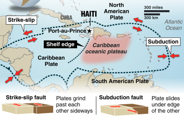
Bronquote:Seven quakes have rocked Caribbean islands as of Saturday and another tremor occurred in Haiti this Monday, raising concern among experts about a likely seismic reactivation in the area. “For some days we have observed an unusual activity that seems to be linked to the subduction of the Caribbean tectonic plate,” Saint Lucian seismologist Bruce Kleever told Prensa Latina. Seven tremors were felt in the British overseas territories in East Caribbean over the weekend, according to the Disaster Management Department of the Virgin Islands. “The seismic events were of 3.5-4.6 magnitude and could also be felt in Puerto Rico. We’re following closely the situation in the area,” said Kleever. A 4.3-magnitude quake rocked southern Haiti early morning today, one year, ten months and two days after the worst seism in the history of this country occurred. No damages or fatalities have been reported so far, but the people panicked as they relived the nightmare. According to the expert, the tremor might indicate an area of seismic activity also in the northern Caribbean plate. For years, the specialists have feared the likelihood of powerful quakes and ensuing tsunamis in the Caribbean because of the existence in the area of important focuses of danger of tectonic movement. One of them is located near Dominica, considered the point with the largest number of potentially active volcanoes in the world. However, Kleever said panic must not be triggered among the population. “Just remain on alert and take steps in case of any tremor,” he said. Steps include going to open, safer spaces, mainly in highlands, far from buildings. The Caribbean currently lacks a tsunami early warning system. Such a device would be likely available by year 2014. Watch over the area is carried out from the Hawaii-based Tsunami Warning Center, in the Pacific. At least 88 tsunamis have occurred in the Caribbean in the past 500 years, the worst of them in 1946, killing some 1,600 people.
quote:Earthquake
Country: Bolivia
State: Departamento del Beni
Location: Puerto Calvimonte
Date: 2011-11-22 : 18:48:15
Magnitude: 6.2
Depth: 533.30 km
bronquote:Earthquake
Country: Bolivia
State:
Location: El Carmen
Date: 2011-11-22 : 18:48:18
Magnitude: 6.6
Depth: 572 km
quote:Manipur experiences 23 minor tremors in a day
Imphal, November 22 2011: According to a reports of the Seismological Observatory, Manipur University, Manipur experiences at least 23 minor tremors in a day but these tremors could not be felt by the people, Director of College Development Council, Manipur University Dr RK Ranjan has disclosed.
He was speaking as Chief Guest of the inaugural function of a 5-day long NSS Mega Festival at Youth Hostel No.3, Khuman Lampak Sports Complex.
The camp is being organized under the aegis of State National Service Scheme (NSS) Cell.
Dr Ranjan informed that these minor tremors could be detected only by earthquake monitoring equipments.
Some experts opined that such repetitive minor tremors is an indication that no major quake would occurred in Manipur while others maintained that these minor tremors are only regrouping of the elements that would ultimately erupted into a devastating quake sooner or later.
In spite of contrasting views, one thing is certain that the land mass of Manipur has been formed along the fold lines that have no joining between one fold and another.
There is one large fold line running from Mao to Churachandpur and this would pose greater risk in the event of a major earthquake and this could happen at any time.
So, there is the need to step up the activities of Disaster Management in Manipur, Dr Ranjan said.

Gaat nog steeds lekker daar...
en ook:quote:BreakingNews Breaking News
Report of 6.1 magnitude earthquake off the coast of Japan - @@W7VOA, @earthquake_jp (translated) bit.ly/vMDze7
3 minutes ago Favorite Retweet Reply
quote:BreakingNews Breaking News
More: Earthquake epicenter off coast of Fukishima, Japan, felt in Tokyo; no tsunami alert posted - @HirokoTabuchi, @W7VOA
48 seconds ago Favorite Retweet Reply
I give myself very good advice
But I very seldom follow it
That explains the trouble that I'm always in
But I very seldom follow it
That explains the trouble that I'm always in
In navolging van het bericht hierboven op 16 november
Doomsday optelsom... fictie... of wordt het straks een nachtmerrie?quote:Volcanic and seismic awakening of Pan-America
The seismic and volcanic awakening of Pan-America is now well underway. The Caribbean Plate comprises an area of roughly 3.2 million square km (1.2 million square miles) and it is undergoing major stress. A series of seismic swarms in this region resulted in the outbreak of a 5.1 magnitude earthquake which struck off the coast of San Juan Puerto Rico this week. The northern boundary of the Caribbean Plate with the North American plate is a transform or strike-slip boundary which runs from the border area of Belize, Guatemala (Motagua Fault), and Honduras in Central America, eastward through the Cayman trough on south of the southeast coast of Cuba, and just north of Hispaniola, Puerto Rico, and the Virgin Islands. Part of the Puerto Rico Trench, the deepest part of the Atlantic Ocean (roughly 8,400 meters), also lies along this border. The Puerto Rico trench is at a complex transition from the subduction boundary to the south and the transform boundary to the west. The Cocos plate on the western border of Pan America is subducting under the Caribbean Plate.
The whole region is becoming more violent as geological forces increase plate pressures on the region and the sea-floor is violently stirred along the Puerto Rico trench. The trench has an unsettling history of producing very powerful earthquakes- 8.1 magnitude earthquakes struck the region both in 1787 and 1946. In light of the rising earthquake risks, UNESCO conducted a Caribbean Tsunami warning exercise on March 23, 2011 in anticipation of a 7.6 magnitude earthquake. It goes without saying, we’re overdue for another major earthquake to strike this region.
As a result of the mounting seismic tension on the western region of the plate, we’re already witnessing the volcanic and seismic awakening of much of Pan-America. On November 20, Mexico’s Popocatepetl volcano unleashed a 5 km ash cloud. On November 22nd, Guatemala’s lofty Fuego volcano followed suit with a 2 km cloud of dark ash. On November 25th, the alert status of Colombia’s Gelaras volcano was raised to orange. On November 26th, the dense upper volcanic belt of El Salvador was shaken by a swarm of over 700 tremors in a 24-hour-period. Now Ecuador’s Tungurahua volcano is the latest telltale sign that the time-bomb in the Atlanic is still ticking.
Nog maar even een optelsom...
Volgens de OP... gemiddeld 20 aardbevingen van 7.0-7.9 per jaar
Waar zitten we nu op?
Januari 4
Februari 0
Maart 1
April 2
Mei 0
Juni 1
Juli 2
Augustus 2
September 2
Oktober 2
November 0
totaal nu 16... gemiddeld genomen nog 4 te gaan in de laatste maand...
Gemiddeld komen er 2 bevingen 8.0 of hoger voor per jaar. Tot nu toe hebben we er één gehad.
December kan een zware maand wordt als moeder aarde zich aan het gemiddelde houdt...
Frutsel, de vorige keer toen je zoiets postte was het toch vrij snel raak? . Als dat nu weer het geval is, verbied ik je nog dat soort dingen te posten 
quote:Ramen sneuvelen bij aardbeving NieuwZeeland
Een aardbeving met een kracht van 5,7 op de schaal van Richter in het noorden van het zuidelijke eiland van Nieuw-Zeeland heeft zaterdag ramen doen sneuvelen in de hoofdstad Wellington.
Er is geen grote schade gemeld, maar volgens een radiozender sneuvelden ramen van een kantoorgebouw in Wellington. Inwoners zagen ook spullen van kasten vallen.
Volgens seismologen lag het epicentrum van de aardbeving 40 kilometer ten westen van Wellington op 60 kilometer diepte. Het zou gaan om de zwaarste aardbeving in de regio sinds 45 jaar. (afp/mvl)
Die bevingen komen dagelijks voor... dus daar is niets raars aan... en ik heb niets voorspeld, alleen dat we vier 7+ bevingen "missen"... en iemand zei dat de laatste keren dat ik zoiets zei het direct raak was

Tja geen idee maarrrrr:quote:
quote:Baja California (Nederlands: Neder-Californië) is een deelstaat van Mexico. De staat ligt op het noordelijk deel van het schiereiland Neder-Californië. Als enige Mexicaanse staat ligt Baja California in de tijdzone UTC-8.
En een provincie Limburg.quote:
[..]
zeeuws vlaanderen hoort bij nederland en belgië heeft ook een provincie die brabant heet.
Your wish is my command... nu is het zeker Mexico.quote:
Mexico opgeschrikt door krachtige aardbeving

http://earthquake.usgs.go(...)c000753u.php#detailsquote:Earthquake Details
This event has been reviewed by a seismologist.
Magnitude 6.5
Date-Time
Sunday, December 11, 2011 at 01:47:26 UTC
Saturday, December 10, 2011 at 07:47:26 PM at epicenter
Time of Earthquake in other Time Zones
Location 18.038°N, 99.796°W
Depth 64.9 km (40.3 miles)
Region GUERRERO, MEXICO
Distances 42 km (26 miles) SW of Iguala, Guerrero, Mexico
56 km (34 miles) ESE of Arcelia, Guerrero, Mexico
62 km (38 miles) NNW of Chilpancingo, Guerrero, Mexico
166 km (103 miles) SSW of MEXICO CITY, D.F., Mexico
Location Uncertainty horizontal +/- 14.5 km (9.0 miles); depth +/- 9.8 km (6.1 miles)
Als het niet met een hamer te repareren is, is het een elektrisch probleem.
quote:'Cycloon veroorzaakt binnen 4 jaar aardbeving'
Amerikaanse wetenschappers zeggen dat ze bewijs hebben gevonden dat tropische regenstormen worden gevolgd door aardbevingen. Ze suggereren dat de zware regenbuien binnen 4 jaar bevingen veroorzaken.
Onderzoekers van de universiteit van Miami bekeken cyclonen en aardbevingen in Haïti en Taiwan.
'Zware neerslag zorgt voor duizenden aardverschuivingen. De erosie verwijdert grondmateriaal van het oppervlak, wat allerlei bewegingen langs breuklijnen veroorzaakt', zei Shimon Wdowinski, professor of zeegeologie en geofysica donderdag op een congres van de American Geophysical Society in San Francisco.


quote:
[..]
Your wish is my command... nu is het zeker Mexico.
Mexico opgeschrikt door krachtige aardbeving
[ afbeelding ]
[..]
http://earthquake.usgs.go(...)c000753u.php#details
The only limit is your own imagination
Ik ben niet gelovig aangelegd en maak daarin geen onderscheid tussen dominees, imams, scharenslieps, autohandelaren, politici en massamedia
Waarom er geen vliegtuig in het WTC vloog
Ik ben niet gelovig aangelegd en maak daarin geen onderscheid tussen dominees, imams, scharenslieps, autohandelaren, politici en massamedia
Waarom er geen vliegtuig in het WTC vloog

Voorschok voor één van de 3 missende 7+ quakesquote:3.6 jolts greater LA area
A magnitude 3.6 earthquake shook the greater Los Angeles area early on Tuesday morning; there are no reports of any damage.
The quake struck at 12:32 a.m. local time, and was centered about 38 miles east of downtown Los Angeles near Ontario, Calif.
According to the USGS, the greatest tremors were felt from the Eastside of L.A. through the western part of the Inland Empire, including in Riverside and Rancho Cucamonga.
Though no damage has been reported, the shaking may have been more severe than what is typical for a magnitude 3.6 quake in this area since it was centered only a mile deep.
Numerous people took to Twitter to report the earthquake.
Curiously enough, the epicenter was displaced from the San Andreas fault, the typical focus for earthquakes in California.
Zou dat nog iets impliceren of is 't een onbeduidende toevalligheid?quote:Curiously enough, the epicenter was displaced from the San Andreas fault, the typical focus for earthquakes in California.
And what rough beast, its hour come round at last,
Slouches towards Bethlehem to be born?
Slouches towards Bethlehem to be born?
wederom zware schokken in Christchurch....5.8
http://www.geonet.org.nz/earthquake/quakes/3631359g.html
http://www.geonet.org.nz/earthquake/quakes/3631359g.html
'Lopen is geen sport maar een manier van reizen'
'Als ik loop voel ik me beroerd, maar als ik niet loop nog beroerder'
'Once you discover the rewards of pain, you want more pain'
'Als ik loop voel ik me beroerd, maar als ik niet loop nog beroerder'
'Once you discover the rewards of pain, you want more pain'
Twee zware aardbevingen in Nieuw-Zeeland
CHRISTCHURCH - Bij de grote Nieuw-Zeelandse stad Christchurch hebben zich vrijdag twee krachtige aardbevingen voorgedaan.
De bevingen had elk een kracht van 5,8 op de schaal van Richter, meldde het Amerikaanse geologische centrum USGS. De tweede schok volgde 70 minuten na de eerste.
De stad werd 10 maanden geleden getroffen door een beving met een kracht van 6,3. Daarbij vielen circa 180 doden.
Een groot deel van het stadscentrum was toen ingestort, een schadepost van circa 9 miljard euro.
Paniek
Na de nieuwe schokken ontstond paniek onder inwoners. Meerdere winkelcentra, kantoren en andere gebouwen werden geëvacueerd.
In enkele buurten zijn de stroom en telefoon uitgevallen. Vooralsnog zijn er alleen berichten over lichtgewonden. De schade lijkt beperkt tot omgevallen spullen en wat barsten in de muren van het casino.
Instorten
''Het hele gebouw schudde. Ik was bang dat het zou instorten'', zei Daniel Yeoh, die aan het lunchen was in een Thais restaurant, tegenover het casino.
''Het was ongelooflijk krachtig'', zei een bewoner van het gebied tegen Radio New Zealand. ''Allerlei spullen zijn op de vloer gevallen, een beetje gebroken glas en fotolijstjes liggen overal.''
Nieuw-Zeeland wordt vaak getroffen door aardbevingen.
nu.nl
toestand wat betreft schade etc. valt gelukkig erg mee... maar ja, nu maar afwachten of er tijdens de kerstdagen niet al te veel naschokken komen.quote:
Gvd, houdt t daar dan nooit op?
Het grote probleem is dat mensen er langzamerhand geestelijk aan onderdoor gaan,steeds maar weer naschokken.... want dit duurt nu al bijna 15 maanden
'Lopen is geen sport maar een manier van reizen'
'Als ik loop voel ik me beroerd, maar als ik niet loop nog beroerder'
'Once you discover the rewards of pain, you want more pain'
'Als ik loop voel ik me beroerd, maar als ik niet loop nog beroerder'
'Once you discover the rewards of pain, you want more pain'
Nou, infrastructuur is wel weer verder beschadigd en van de cathedral blijft ook steeds minder over.quote:
[..]
toestand wat betreft schade etc. valt gelukkig erg mee... maar ja, nu maar afwachten of er tijdens de kerstdagen niet al te veel naschokken komen.
Het grote probleem is dat mensen er langzamerhand geestelijk aan onderdoor gaan,steeds maar weer naschokken.... want dit duurt nu al bijna 15 maanden
En inderdaad de naschokken.... Zo kut is dat... Zo maar eens een mailtje die kant opgooien hoe het is..
schade aan de infrastructuur lijkt mee te vallen...wel hoop huizen zonder stroom maar dat blijkt meer een kwestie van "tripping' te zijn i.p.v. daadwerkelijke schade aan het netwerk.quote:
[..]
Nou, infrastructuur is wel weer verder beschadigd en van de cathedral blijft ook steeds minder over.
En inderdaad de naschokken.... Zo kut is dat... Zo maar eens een mailtje die kant opgooien hoe het is..
'Lopen is geen sport maar een manier van reizen'
'Als ik loop voel ik me beroerd, maar als ik niet loop nog beroerder'
'Once you discover the rewards of pain, you want more pain'
'Als ik loop voel ik me beroerd, maar als ik niet loop nog beroerder'
'Once you discover the rewards of pain, you want more pain'
Ja, had ik ook gelezen ja. Gelukkig maar. Wel weer hier en daar wat liquefaction. Geeft ook een bende en gaten in de wegen.quote:
[..]
schade aan de infrastructuur lijkt mee te vallen...wel hoop huizen zonder stroom maar dat blijkt meer een kwestie van "tripping' te zijn i.p.v. daadwerkelijke schade aan het netwerk.
Hopelijk wordt t snel wat rustiger.
het heeft de hele nacht flink door gerommelt
http://www.geonet.org.nz/earthquake/quakes/recent_quakes.html
Kia Kaha CHCH !!
http://www.geonet.org.nz/earthquake/quakes/recent_quakes.html
Kia Kaha CHCH !!
'Lopen is geen sport maar een manier van reizen'
'Als ik loop voel ik me beroerd, maar als ik niet loop nog beroerder'
'Once you discover the rewards of pain, you want more pain'
'Als ik loop voel ik me beroerd, maar als ik niet loop nog beroerder'
'Once you discover the rewards of pain, you want more pain'
quote:Quake rattles New Zealand's Christchurch
Dec 31 (Reuters) - An earthquake with a magnitude of 5.3 struck close to the New Zealand city of Christchurch on Saturday, the U.S. Geological Survey reported, but there were no immediate reports of damage or casualties.
The quake was measured only about 14 km (9 miles) northeast of the city. It was another in a series of quakes that have rattled the city since a major earthquake killed almost 200 people there 10 months ago.
There were no immediate reports of a tsunami warning.
A quake of a similar magnitude was felt in the area on Dec. 23, sending terrified residents from their houses but causing no casualties or major damage.
Christchurch, the largest city in New Zealand's South Island, is still recovering from a quake measuring 6.3 that killed 182 people in February and caused up to NZ$20 billion ($15.5 billion) in damage.
Large areas of Christchurch's business district are still off limits after the February quake, which toppled the city's famous cathedral, as well as shops, office buildings and homes.
New Zealand straddles the boundaries of the Indo-Australian and the Pacific tectonic plates and is hit by about 14,000 quakes every year, of which only a small number top a magnitude of 5.
En ook in t nieuwe jaar rommelt t gewoon door in christchurch
En Japan ook weer trouwens. Hopelijk kan t alleen maar minder worden dat geschud. Ik hoop het voor ze, maar dat zal wel niet.
En Japan ook weer trouwens. Hopelijk kan t alleen maar minder worden dat geschud. Ik hoop het voor ze, maar dat zal wel niet.
ook vannacht weer een 5.5quote:
En ook in t nieuwe jaar rommelt t gewoon door in christchurch
En Japan ook weer trouwens. Hopelijk kan t alleen maar minder worden dat geschud. Ik hoop het voor ze, maar dat zal wel niet.
'Lopen is geen sport maar een manier van reizen'
'Als ik loop voel ik me beroerd, maar als ik niet loop nog beroerder'
'Once you discover the rewards of pain, you want more pain'
'Als ik loop voel ik me beroerd, maar als ik niet loop nog beroerder'
'Once you discover the rewards of pain, you want more pain'
Ja, meerdere shakes weer geweest en heel wat huishoudens zonder stroom. Ik had zo voor de mensen daar gehoopt dat 2012 wat rustiger zou beginnen.
Nu ruim 10 maanden geleden dat alles daar helemaal compleet instortte (voorafgegaan door wat minder grote schadequakes)
Nu ruim 10 maanden geleden dat alles daar helemaal compleet instortte (voorafgegaan door wat minder grote schadequakes)
Inmiddels gedowngrade naar 6.8?quote:
Ik hoorde net op de radio zware aardbeving Japan. 2012 is begonnen :S
Ik dacht dat het een 7+ was... maar goed, het één en ander gemist deze week .
Plus dat januari 2011 ook met vier bevingen van 7 of hoger begon... deze dus een 6.8
quote:17 aardbevingen in 18 uur tijd voor Christchurch
De Nieuw-Zeelandse stad Christchurch is op 18 uur tijd 17 keer door elkaar geschud door aardbevingen. Er is voorlopig geen sprake van grote schade.
Christchurch, de grootste stad van het zuidereiland, wordt al sinds september 2010 geteisterd door aardbevingen. Bij de beving in februari vorig jaar vielen nog 181 doden.
Onder de bevingen van vandaag waren er twee sterker dan 5 op de schaal van Richter.
De stad vraagt in een mededeling aan de inwoners om "te zorgen voor vrienden, buren en familie in deze moeilijke tijden". Burgemeester Bob Parker verzekerde dat de stad er alles aan doet om de belangrijkste diensten operationeel te houden. (dpa/adha)
Bleh, je zult daar maar wonen. 
And what rough beast, its hour come round at last,
Slouches towards Bethlehem to be born?
Slouches towards Bethlehem to be born?

Gaat ook goed bij Tenerife
5 bevingen (niet al te zwaar) op een rechte lijn.
[ Bericht 23% gewijzigd door bwt op 05-01-2012 17:07:02 ]
5 bevingen (niet al te zwaar) op een rechte lijn.

quote:And are today, January 5, five sismitos around Tenerife, one of Puerto NW, about 11 km from the coast, and the other 4 SE of Candelaria, in a straight line, the farthest about 12 '5 km and the closest to a 4,5 km from the coast, in between the other two, closer, about 6km, and very close together. The size of each map. (Humberto)

quote:Update 05/01 15:22 UTC
- A very curious pattern in GPS deformation patterns (the data which are published are probably 2 days old). The deformation at HI02, HI03 and HI04 climbed strongly ! La Palma deformation stayed approx. the same, but Tenerife and La Gomera GPS data decreased the strongest since the beginning of El Hierro activity. The current earthquakes at Tenerife may have an origin in this strong deflation (tension). The smoking lava Yesterday and Today also. @ IGN to solve the clue here. Hopefully they will explain in their report later today.
quote:There seems to be moving in the Border GPS station in the last two days, in every season reflects a movement that has similar characteristics and should be monitored to see if it continues the next day.
Comparing the data of IGN compared to other stations of Frontera, it's like Frontera station was moving to the east, as there is no relative motion with respect to NS Palma and a movement of approach compared to the Tenerife. HI02, HI03 and HI04 seem to have the same pattern of separation.
As for the vertical deformation .... will have to wait to see part of IGN happens, but if some do not move and goes to the East border, depart hence, it is conceivable that there should be an inflation (Enrique) .
[bron]
[ Bericht 23% gewijzigd door bwt op 05-01-2012 17:07:02 ]
<a href="http://goo.gl/q8fhTe" target="_blank">FAQ?</a>
<a href="http://goo.gl/gYvZFq" target="_blank">Geel is een zonnige en vrolijke kleur, als hij tenminste enigszins warm is gekleurd en wat naar het oranje neigt</a>
<a href="http://goo.gl/gYvZFq" target="_blank">Geel is een zonnige en vrolijke kleur, als hij tenminste enigszins warm is gekleurd en wat naar het oranje neigt</a>
quote:4,5 quake rattles Christchurch
At 1:21 a.m. local time (7:21 a.m. Eastern), a 4.5-magnitude earthquake struck New Zealand, roughly 25 kilometers east of Cristchurch. It originated from approximately 6.2 miles below the surface.
The area is not a stranger to earthquakes, as they were hit by a 5.8-magnitude tremor just two days before Christmas. There were thousands of recorded aftershocks following a 7.0-magnitude quake that struck on Sept. 4, 2010. Amazingly, no deaths resulted from that earthquake.
There have been no reports of injuries or damage from this earthquake, but we will keep you updated as details roll in.

quote:MAP 4.5 2012/01/06 12:21:35 -43.547 172.982 9.9 SOUTH ISLAND OF NEW ZEALAND
MAP 4.7 2012/01/06 07:04:16 -43.508 172.825 11.3 SOUTH ISLAND OF NEW ZEALAND
MAP 4.5 2012/01/06 01:20:57 -43.481 172.913 8.4 SOUTH ISLAND OF NEW ZEALAND
MAP 4.5 2012/01/02 05:59:14 -43.453 172.897 13.2 SOUTH ISLAND OF NEW ZEALAND
MAP 5.2 2012/01/01 16:45:04 -43.428 172.892 10.6 SOUTH ISLAND OF NEW ZEALAND
MAP 5.0 2012/01/01 12:27:56 -43.472 172.952 13.8 SOUTH ISLAND OF NEW ZEALAND
MAP 5.3 2011/12/31 00:44:46 -43.484 172.823 10.1 SOUTH ISLAND OF NEW ZEALAND
quote:6.6 Quake strikes off the Santa Cruz Islands
LATA, SOLOMON ISLANDS (BNO NEWS) -- A strong earthquake struck off the Santa Cruz Islands in the Pacific Ocean on late Monday afternoon, seismologists said, but there were no immediate reports of damage or casualties.
The 6.6-magnitude earthquake at 3:07 p.m. local time (0407 GMT) was centered about 75 kilometers (46 miles) west-northwest of Lata, the provincial capital of Temotu Province on Nendo island, which is part of the Santa Cruz Islands in the Solomon Islands. It struck about 38.9 kilometers (24.2 miles) deep, making it a shallow earthquake, according to the United States Geological Survey (USGS).
The USGS estimated that approximately 14,000 people on islands in the region may have felt strong shaking, which would be unlikely to result in serious damage or casualties. Tens of thousands more may have felt weak to moderate shaking, but there were no initial reports of damage.
Both the Pacific Tsunami Warning Center (PTWC) and the Joint Australian Tsunami Warning Center (JATWC) said there was no threat of a tsunami. "No destructive widespread tsunami threat exists based on historical earthquake and tsunami data," PTWC said in a bulletin.
The Solomon Islands are on the so-called 'Pacific Ring of Fire', an arc of fault lines circling the Pacific Basin that is prone to frequent and large earthquakes. Volcanic eruptions also occur frequently in the region.
The Solomon Islands arc as a whole experiences a very high level of earthquake activity, and many tremors of magnitude 7 and larger have been recorded since the early decades of the twentieth century.
On April 2, 2007, a massive 8.1-magnitude earthquake struck close to the New Georgia Islands of the Solomon Islands. It unleashed a regional tsunami, killing 52 people and destroying more than 300 homes, schools and a hospital at Sasamunga. Two people were killed as a result of landslides, which were triggered by the earthquake

http://earthquake.usgs.go(...)uakes/usc0007ir5.php
Depth: 29.1 km (18.1 miles)
De tsunami-voorspelling is gelukkig vrij gunstig zo te lezen:
Depth: 29.1 km (18.1 miles)
De tsunami-voorspelling is gelukkig vrij gunstig zo te lezen:
http://ptwc.weather.gov/p(...)BIOX.2012.01.10.1845quote:EVALUATION
A DESTRUCTIVE WIDESPREAD TSUNAMI THREAT DOES NOT EXIST BASED ON
HISTORICAL EARTHQUAKE AND TSUNAMI DATA.
HOWEVER - THERE IS A VERY SMALL POSSIBILITY OF A LOCAL TSUNAMI
THAT COULD AFFECT COASTS LOCATED USUALLY NO MORE THAN A HUNDRED
KILOMETERS FROM THE EARTHQUAKE EPICENTER. AUTHORITIES IN THE
REGION NEAR THE EPICENTER SHOULD BE MADE AWARE OF THIS
POSSIBILITY.
And what rough beast, its hour come round at last,
Slouches towards Bethlehem to be born?
Slouches towards Bethlehem to be born?
Het gaat allemaal weer lekker te keer, ben benieuwd wat we dit jaar weer gaan krijgen, LA aan de beurt?
Doe mee met het voorspellen van het weer!
Weekvoorspelling | Week 12 (invullen tot 16-03 - 11:59)
Maandvoorspelling Maart (Inzendingen gesloten)
Jaarvoorspelling 2025 / 2026
Weekvoorspelling | Week 12 (invullen tot 16-03 - 11:59)
Maandvoorspelling Maart (Inzendingen gesloten)
Jaarvoorspelling 2025 / 2026
Mag wel eens tijd wordenquote:
Het gaat allemaal weer lekker te keer, ben benieuwd wat we dit jaar weer gaan krijgen, LA aan de beurt?
Ik hoop het niet. Bij elke aardbeving schudden er namelijk dozijnen 2012 believers en trollen onder hun stenen vandaan. Gek wordt je ervan.
Opgeblazen gevoel of winderigheid? Zo opgelost met Rennie!
Seismic server flipt de pan uit:
Nog veel meer locaties.... zie:
http://earthquake.usgs.go(...)ns/heliplots_gsn.php
[ Bericht 7% gewijzigd door #ANONIEM op 11-01-2012 00:52:15 ]

Nog veel meer locaties.... zie:
http://earthquake.usgs.go(...)ns/heliplots_gsn.php
[ Bericht 7% gewijzigd door #ANONIEM op 11-01-2012 00:52:15 ]

wat betekend dit?quote:
Seismic server flipt de pan uit:
[ afbeelding ]
Nog veel meer locaties.... zie:
http://earthquake.usgs.go(...)ns/heliplots_gsn.php
Herman Finkers... He buurman, ik hier ?
Dan zou je iig niet in Brazillië willen zittenquote:
Seismic server flipt de pan uit:
[ afbeelding ]
Nog veel meer locaties.... zie:
http://earthquake.usgs.go(...)ns/heliplots_gsn.php
*zet alvast alu-2012-hoedje op


Lijkt gelukkig te ver weg voor aanzienlijke schade, maar een 6.1 is voor Nieuw Zeelanders toch altijd schrikken nu.
Zie ook
Theorie: Aardbevingen Christchurch voortekenen van vulkaanuitbarsting?
quote:Magnitude mb 5.4
Region NORTHEASTERN IRAN
Date time 2012-01-19 12:35:52.0 UTC
Location 36.49 N ; 59.06 E
Depth 10 km
Distances 37 km NE Neyshabur (pop 220,929 ; local time 16:05:52.0 2012-01-19)
18 km S Chenaran (pop 46,940 ; local time 16:05:52.0 2012-01-19)

quote:Series of quakes strike North Island
A flurry of small earthquakes has rattled the North Island this morning.
Two early-morning quakes rumbled under Taupo in the wee hours, both at relatively shallow depths.
The first, at 3.07am, measured magnitude 2.9 and hit at a depth of 5km, 10km west of Taupo.
The second, in the same place but at a depth of 2km and measuring 2.4, hit at 4.55am.
Both were felt by Taupo residents, Geonet reported.
Two slightly larger quakes hit Napier and Hastings later in the morning, with the largest measuring 4.3.
The quake was centred 30km southeast of Hastings at a depth of 30km, and hit at 8.49am.
Geonet reported the quake was felt as far south as Waipakurau.
A 3.3 quake was reported just two minutes earlier, at a depth of 20 km, 20km south of Hastings.
There were no reports of damage.
quote:Christchurch rumbled by series of quakes
A 24-hour period without earthquakes ended for Christchurch residents with a 3.7, a 4.5 and then a 4.0-magnitude tremor this morning.
The 3.7-magnitude quake, which struck shortly before 3am, was centred 10 kilometres east of Christchurch at a depth of 10km.
The 4.5-magnitude quake struck at 6.46am, centred 20km east of Christchurch at a depth of 12km, while the 4.0-magnitude shake struck just after 8.30am, centred 20km west of Christchurch and 9km deep.
The continued shaking comes as the city's business leaders call for urgent decisions to be made on the siting of Christchurch's new convention centre and the future of AMI Stadium.
Canterbury Employers' Chamber of Commerce chief executive Peter Townsend said authorities could not afford to dally over positioning of infrastructure assets such as the convention centre because it was critical to determining where other developments would go.
"The centre's siting and AMI Stadium are key decisions required immediately," he said.
"They are critical to what will happen in a lot of the rest of the city."
Demolition of the city's quake-damaged convention centre started last week.
The city council plans to build a $200 million replacement but has yet to confirm where it will be built.
quote:75% chance of a 7+ quake hitting Tokyo within 4 years
A big earthquake is much more likely to hit the Japanese capital, Tokyo, in the next few years than the government has predicted, researchers say.
The team, from the University of Tokyo, said there was a 75% probability that a magnitude 7 quake would strike the region in the next four years.
The government says the chances of such an event are 70% in the next 30 years.
The warning comes less than a year after a massive earthquake and tsunami devastated Japan's north-eastern coast.
The last time Tokyo was hit by a big earthquake was in 1923, when a 7.9 magnitude quake killed more than 100,000 people, many of them in fires.
Researchers at the University of Tokyo's earthquake research institute based their figures on data from the growing number of tremors in the capital since the 11 March 2011 quake.
They say that compared with normal years, there has been a five-fold increase in the number of quakes in the Tokyo metropolitan area since the March disaster.
They based their calculations on data from Japan's Meteorological Agency, They said their results show that seismic activity had increased in the area around the capital, which in turn leads to a higher probability of a major quake.
The researchers say that while it is "hard to predict" the casualty impact of a major quake on Tokyo, the government and individuals should be prepared for it.
Correspondents say that while the university calculations take account of greater seismic activity since March, government calculations may use different or less up-to-date data and different modelling techniques.
The 9.0 magnitude earthquake last year aksi crippled the cooling systems at the Fukushima nuclear power station, causing meltdowns in some of its reactors.
Japan is located on a tectonic crossroads dubbed the "Pacific Ring of Fire" which is why its is commonly regarded as one of the world's most quake-prone countries, with Tokyo located in one of the most dangerous areas.

Flinke beving in Italy... 5.1
Deed me ff denken aan L'Aquila uit 2009 maar die was denk ik 6.0 ofzo
Hopelijk valt hier de schade mee
quote:Noord-italie opgeschrikt door aardbeving
Het noorden van Italië is vanmorgen opgeschrikt door een aardbeving. In Milaan liepen veel mensen ongerust de straat op. In gebouwen vielen allerlei voorwerpen, maar er zijn geen berichten over doden of gewonden. Dat hebben Italiaanse media gemeld.
De krachtigste aardbeving - 4,9 op de schaal van Richter - vond volgens het nationaal geofysisch instituut rond 9 uur plaats. Het epicentrum van die beving bevond zich nabij de stad Reggio Emilia, in de regio Emilia-Romagna. Ook in Milaan, de op een na grootste stad van het land, was de schok voelbaar. De aardschokken zijn gevoeld in de regio's Lombardije, Emilia-Romagna, Veneto en Piemonte.
Vannacht had zich al een aardbeving met een kracht van 4,2 op de schaal van Richter voorgedaan in de buurt van Verona, gevold door een naschok met een magnitude van 2,9.
Grote delen van Italië zijn seismisch actief gebied. Bij de aardbeving in L'Aquila in 2009 vielen meer dan 300 doden. In december 1908 vielen in Sicilië en Calabrië ongeveer 100.000 doden door verwoestende aardschokken. (belga/adha/sg)
KSC JUBILEUM topic
"Sleep: A completely inadequate substitute for caffeine"
#TeamHumbug
Heeft patent op Mosterd-Maaltijd situaties
"Sleep: A completely inadequate substitute for caffeine"
#TeamHumbug
Heeft patent op Mosterd-Maaltijd situaties

KSC JUBILEUM topic
"Sleep: A completely inadequate substitute for caffeine"
#TeamHumbug
Heeft patent op Mosterd-Maaltijd situaties
"Sleep: A completely inadequate substitute for caffeine"
#TeamHumbug
Heeft patent op Mosterd-Maaltijd situaties
quote:
 Op
Op quote:125 injuries in Peru after quake
Update 21:15UTC: 125 people are reported to be injured (108 from the province of Ica (of which 73 from Dist. Ica, 6 from the Dist. Ocucaje, 10 from Dist. Parcona, 1 from Dist. Santiago, 6 from Dist. Tinguina, 10 from Dist. Guadalupe); 12 from the province of Pisco; 7 from the province of Chincha).
140 people are homeless of which 115 are in the Province of Ica and 25 from the Province of Pisco.
28 houses are uninhabitable (23 in Ica, 5 in Pisco) and 27 additional houses are damaged.
The 125 injured have been serviced and taken care of at local hospitals and health centers.
Earthquake-report.com commends INDECI for their speedy and also intensive and detailed work in collecting the damage statistics. A lot of much more developed nations could learn much from the Peruvian press reporting of disasters.

MAP 5.3 2012/02/02 13:57:07 -17.462 167.169 10.0 VANUATU
MAP 4.9 2012/02/02 13:53:45 -17.597 167.191 13.4 VANUATU
MAP 6.9 2012/02/02 13:34:38 -17.810 167.149 10.1 VANUATU
MAP 4.9 2012/02/02 13:53:45 -17.597 167.191 13.4 VANUATU
MAP 6.9 2012/02/02 13:34:38 -17.810 167.149 10.1 VANUATU
Vanuatu opgewaardeerd naar 7.1
Aardig lijstje wordt het alweer.
Aardig lijstje wordt het alweer.
quote:MAP 4.9 2012/02/03 08:13:17 -17.953 167.817 18.5 VANUATU
MAP 5.7 2012/02/03 06:01:41 -17.380 167.183 24.9 VANUATU
MAP 5.4 2012/02/03 04:33:09 -17.484 167.232 23.8 VANUATU
MAP 6.0 2012/02/03 03:46:23 -17.376 167.278 21.7 VANUATU
MAP 4.8 2012/02/02 21:47:52 -17.523 167.235 9.9 VANUATU
MAP 5.1 2012/02/02 20:26:31 -17.519 167.359 17.4 VANUATU
MAP 5.1 2012/02/02 19:44:35 -17.457 167.229 31.9 VANUATU
MAP 4.9 2012/02/02 19:20:45 -17.996 167.828 10.3 VANUATU
MAP 5.2 2012/02/02 17:28:47 -17.596 167.339 20.8 VANUATU
MAP 5.5 2012/02/02 17:27:07 -17.963 167.209 22.8 VANUATU
MAP 5.0 2012/02/02 16:04:45 -17.779 167.233 33.3 VANUATU
MAP 5.3 2012/02/02 13:57:07 -17.462 167.169 10.0 VANUATU
MAP 4.9 2012/02/02 13:53:45 -17.597 167.191 13.4 VANUATU
MAP 7.1 2012/02/02 13:34:40 -17.766 167.134 23.1 VANUATU

quote:At least 13 killed in 6.8 quake
MANILA, Philippines (AP) -- A strong earthquake in the central Philippines killed at least 13 people Monday as it destroyed buildings and triggered landslides that buried dozens of houses, trapping residents. At least 29 people were missing.
The 6.8-magnitude quake, in a narrow strait just off Negros Island, caused a landslide in Guihulngan, a city of about 180,000 people in Negros Oriental province. As many as 30 houses were buried and at least 29 people were missing, Mayor Ernesto Reyes said.
"Their situation is bad because if you are covered by landslide for one hour, two hours, how can you breathe?" he said. "But we just hope for the best, that there are still survivors."
Rescuers were using picks and shovels to dig for survivors, he said.
Reyes said at least 10 people were confirmed dead in his town, including students at a college and an elementary school and others in a market that collapsed. About 100 were injured.
The quake, which hit at 11:49 a.m. (0349 GMT), triggered another landslide in the mountain village of Solongon in La Libertad town, also in Negros Oriental. An unknown number of people were trapped, said La Libertad police chief inspector Eric Arrol Besario.
"We're now getting shovels and chain saws to start a rescue because there were people trapped inside. Some of them were yelling for help earlier," Besario told The Associated Press by phone. Three key bridges in the town suffered cracks and were no longer passable, he said.
Philippine seismologists briefly issued a tsunami alert for the central islands. Five bamboo and wooden cottages were washed out from a beach resort in La Libertad by huge waves, but there were no reports of injuries, said police Superintendent Ernesto Tagle. Elsewhere along the coast, people rushed out of schools, malls and offices.
The epicenter was closest to Tayasan, a coastal town of about 32,000 people flanked by mountains in Negros Oriental province. Two died there, including a child when a concrete fence of a house collapsed, said Benito Ramos, head of the Office of Civil Defense.
Another child was killed in a church when a wall collapsed during a funeral in Negros Oriental's Jimalalud town, Mayor Reynaldo Tuanda said.
Tayasan police officer Alfred Vicente Silvosa told The AP by phone that aftershocks were preventing people from returning to their homes. Seismologists recorded nearly 45 aftershocks.
"We are outside, at the town plaza. We cannot inspect buildings yet because it's dangerous," Silvosa said. "I felt the building shaking, so I rushed out of the building. Our computers, shelves, plates, the cupboards, water dispenser all fell."
A three-story office building also collapsed in La Libertad, but occupants managed to run out.
Negros Oriental police chief Edward Carranza said the temblor damaged many houses in Guihulngan and he ordered his men to help displaced residents find shelter.
Officials in some areas suspended work and canceled classes. Power and telecommunications were knocked out in several places.
Carranza said police rushed out of his building when the quake struck. "All my personnel ran out fearing our building would collapse," he said.
"Now it's shaking again," he said as an aftershock hit. "My keychain is dancing."
The U.S. Geological Survey said the quake was centered 44 miles (72 kilometers) north of Dumaguete city on Negros and hit at a depth of 29 miles (46 kilometers). The area is about 400 miles (650 kilometers) southeast of the capital, Manila.
The Philippines is located in the Pacific "Ring of Fire" where earthquakes and volcanic activity are common. A 7.7-magnitude quake killed nearly 2,000 people in Luzon in 1990.
vlak bij mijn vakantieoord 2 jaar geleden :-)
Trouwen, in een ander topic stelde ik dat:
Trouwen, in een ander topic stelde ik dat:
Klopt dit eigenlijk wel?quote:
dat kan, aardbevingsgolven schijnen van de aardkern af te ketsen. Het hele technische verhaal heb ik zo niet bij de hand. Maar als de tijden overeen komen...
De tremors zijn wel gelijk een stuk minder geworden.... Drukopbouw?
Spannende dag voor de el hierro watchers ;-)
Inorbit: zeg dat dan typluie triangeljosti
Beauregard: Een beetje FOK!ker laat het brood door z'n moeder smeren.
Ecosia
ek's 'n flash drive, jy's 'n floppy
Beauregard: Een beetje FOK!ker laat het brood door z'n moeder smeren.
Ecosia
ek's 'n flash drive, jy's 'n floppy
KSC JUBILEUM topic
"Sleep: A completely inadequate substitute for caffeine"
#TeamHumbug
Heeft patent op Mosterd-Maaltijd situaties
"Sleep: A completely inadequate substitute for caffeine"
#TeamHumbug
Heeft patent op Mosterd-Maaltijd situaties
oh crap, das wel weer heftig...
Zijn het niet de orkanen / moesonbuien of terroristen die de buurt opschrikken zijn het wel aardbevingen...
Zijn het niet de orkanen / moesonbuien of terroristen die de buurt opschrikken zijn het wel aardbevingen...
Inorbit: zeg dat dan typluie triangeljosti
Beauregard: Een beetje FOK!ker laat het brood door z'n moeder smeren.
Ecosia
ek's 'n flash drive, jy's 'n floppy
Beauregard: Een beetje FOK!ker laat het brood door z'n moeder smeren.
Ecosia
ek's 'n flash drive, jy's 'n floppy
Live-updates van de quake op de Filipijnen
Welk deel bedoel je? Dat aardbevingsgolven van de kern afketsen?quote:
ja, dat stukjequote:
Live-updates van de quake op de Filipijnen
[..]
Welk deel bedoel je? Dat aardbevingsgolven van de kern afketsen?
Inorbit: zeg dat dan typluie triangeljosti
Beauregard: Een beetje FOK!ker laat het brood door z'n moeder smeren.
Ecosia
ek's 'n flash drive, jy's 'n floppy
Beauregard: Een beetje FOK!ker laat het brood door z'n moeder smeren.
Ecosia
ek's 'n flash drive, jy's 'n floppy
Weet alleen dat er verschillende golven bij aardbevingen vrijkomen... en afhankelijk qua diepte en qua beweging.
Wiki zegt dit erover
http://en.wikipedia.org/wiki/Seismic_wave
Wiki zegt dit erover
http://en.wikipedia.org/wiki/Seismic_wave
hmm, ja dus... maar niets over de sterkte...
Thanks fruts!
Thanks fruts!
Inorbit: zeg dat dan typluie triangeljosti
Beauregard: Een beetje FOK!ker laat het brood door z'n moeder smeren.
Ecosia
ek's 'n flash drive, jy's 'n floppy
Beauregard: Een beetje FOK!ker laat het brood door z'n moeder smeren.
Ecosia
ek's 'n flash drive, jy's 'n floppy
Rommelt flink daar zegtwitter:Kirstenmildren twitterde op maandag 06-02-2012 om 13:28:16 #Philippines Armed Forces report 46 deaths, collapse of two bridges and three-storey building, in Negros Oriental province from EQ reageer retweet

quote:MAP 5.2 2012/02/06 11:40:20 9.845 123.041 36.5 NEGROS - CEBU REGION, PHILIPPINES
MAP 6.0 2012/02/06 11:33:37 9.804 123.051 15.1 NEGROS - CEBU REGION, PHILIPPINES
MAP 6.0 2012/02/06 10:10:24 9.874 123.070 15.0 NEGROS - CEBU REGION, PHILIPPINES
MAP 5.6 2012/02/06 04:20:04 10.058 123.171 34.6 NEGROS - CEBU REGION, PHILIPPINES
MAP 6.7 2012/02/06 03:49:17 9.964 123.246 20.0 NEGROS - CEBU REGION, PHILIPPINES

naschokken hoog in de 5, tegen 6?
Krijgen we een nieuwe fukushima?
Krijgen we een nieuwe fukushima?
Inorbit: zeg dat dan typluie triangeljosti
Beauregard: Een beetje FOK!ker laat het brood door z'n moeder smeren.
Ecosia
ek's 'n flash drive, jy's 'n floppy
Beauregard: Een beetje FOK!ker laat het brood door z'n moeder smeren.
Ecosia
ek's 'n flash drive, jy's 'n floppy

quote:Dodental Filipijnen naar beneden bijgesteld
Het dodental van de aardbeving op de Filipijnen is naar beneden herzien. Volgens een nieuwe balans kwamen 26 mensen om en zijn er nog 71 vermisten. Zij liggen vermoedelijk bedolven onder het puin en de modder. Een eerdere slachtofferbalans maakte melding van 48 doden en 92 vermisten.
De aardbeving van maandag had een kracht van 6,7 op de schaal van Richter en veroorzaakte heel wat schade. Er wordt nog altijd gezocht naar slachtoffers, maar drie dagen na de ramp wordt de kans om nog overlevenden aan te treffen steeds kleiner. (afp/adv)

Breaking: 5.5 beving noord californie.
voorschok? :x
[ Bericht 51% gewijzigd door Frutsel op 14-02-2012 11:51:12 ]
Laten we het niet hopen...
Inorbit: zeg dat dan typluie triangeljosti
Beauregard: Een beetje FOK!ker laat het brood door z'n moeder smeren.
Ecosia
ek's 'n flash drive, jy's 'n floppy
Beauregard: Een beetje FOK!ker laat het brood door z'n moeder smeren.
Ecosia
ek's 'n flash drive, jy's 'n floppy

quote:Aardbevingen treffen Japan, Griekenland en Californië
Een aardbeving met magnitude 6,2 heeft het noordoosten van Japan dooreengeschud, zo heeft het Meteorologisch Agentschap meegedeeld. Er zijn nog niet meteen berichten over slachtoffers of schade. Ook in Californië en Griekenland ging de aarde aan het beven.
De aarde beefde om 7.22 uur Belgische tijd, met een epicentrum op 165 km ten oostnoordoost van Tokio, aldus het Amerikaanse Geofysisch Instituut USGS dat van een magnitude 6,0 gewaagt. Het epicentrum bevond zich op 10 km diepte. Er is geen nieuwe schade of abnormaals gemeld aan het reeds zwaar gehavende kernpark Fukushima.
Op 11 maart was het noordoosten van Japan zwaar getroffen door een aardbeving met magnitude 9,0 en een tsunami. Er kwamen meer dan 15.800 mensen om en bijna 3.300 worden vermist. Bij drie van de zes reactoren van Fukushima trad een meltdown op, terwijl er radioactief materiaal ontsnapte.
Weitchpec
Ook in het noorden van Californië ging de aarde aan het beven. Om 22u Belgische tijd is daar een beving met magnitude van 5,6 opgemeten, zo heeft het Amerikaanse Geofysisch Instituut USGS gemeld. Het epicentrum bevond zich op 10 km van het stadje Weitchpec, in een regio waar aardbevingen niet ongewoon zijn, en op een diepte van 33 km. Volgens een officier op het kantoor van de sheriff van de county Humboldt lijken er noch slachtoffers te zijn gevallen, noch schade te zijn ontstaan.
Thessaloniki
Ten slotte heeft een aardbeving ook het noordoosten van Griekenland getroffen. Er zijn niet meteen berichten over slachtoffers of schade, aldus functionarissen. De beving deed zich voor om 2.34 uur Belgische tijd. Volgens het Griekse instituut bedroeg de magnitude 5,1, volgens het Amerikaanse 5,3. Het epicentrum bevond zich volgens het Griekse instituut 24 km onder de zeebodem, 110 km ten zuidoosten van Thessaloniki, de twedee grootste stad van Griekenland. Het Amerikaanse USGS gewaagde van 16,7 km diepte. Er waren nog meerdere kleinere naschokken. (belga/odbs)

6.0 voor de kust van Oregon (USA)
Je zou na deze beving, plus de 5.5 in het noorden van Californie en 5.0 in het zuiden dat de stress op de plaat groot is
(en ik laat dan de 5+ bevingen bij Costa Rica, Peru, Chili maar even achterwege)

Mijn 3e aardbeving meegemaakt. Voelde hem niet, zat in de bus. 4,6 in Lima.
The only limit is your own imagination
Ik ben niet gelovig aangelegd en maak daarin geen onderscheid tussen dominees, imams, scharenslieps, autohandelaren, politici en massamedia
Waarom er geen vliegtuig in het WTC vloog
Ik ben niet gelovig aangelegd en maak daarin geen onderscheid tussen dominees, imams, scharenslieps, autohandelaren, politici en massamedia
Waarom er geen vliegtuig in het WTC vloog
Een jaar geleden liep ik in christchurch... Over een kwartier een jaar geleden schudde de aarde en zag ik een kerk instorten. Een jaar geleden liep ik in een stad dat leek op een oorlogsgebied.
Ik ben blij dat ik in Nederland ben, maar denk veel aan christchurch en zeker vandaag.0
Ik ben blij dat ik in Nederland ben, maar denk veel aan christchurch en zeker vandaag.0


5+ voor de kust van Sumatra. Niet bijzonder... maar ik vind het verdacht stil qua grote bevingen
Nog maar één 7+ dit jaar en ook eind vorig jaar geen grote bevingen.
Veel 5+ bevingen aan de oostkant van de Pacifische plaat van Chili via Centraal America, de VS en Alaska...
Er broeit wat...
Nog even en je kunt jezelf een kickje naar TRU gevenquote:Op woensdag 22 februari 2012 13:38 schreef Frutsel het volgende:
[ afbeelding ]
5+ voor de kust van Sumatra. Niet bijzonder... maar ik vind het verdacht stil qua grote bevingen
Nog maar één 7+ dit jaar en ook eind vorig jaar geen grote bevingen.
Veel 5+ bevingen aan de oostkant van de Pacifische plaat van Chili via Centraal America, de VS en Alaska...
Er broeit wat...
Dare to unleash my rage..
That's my secret Captain... I'm always angry...
There's nothing like a trail of blood, to find your way back home.
That's my secret Captain... I'm always angry...
There's nothing like a trail of blood, to find your way back home.
Rare vraag misschien, maar hoe kijk je er op terug?quote:
Een jaar geleden liep ik in christchurch... Over een kwartier een jaar geleden schudde de aarde en zag ik een kerk instorten. Een jaar geleden liep ik in een stad dat leek op een oorlogsgebied.
Ik ben blij dat ik in Nederland ben, maar denk veel aan christchurch en zeker vandaag.0
Dare to unleash my rage..
That's my secret Captain... I'm always angry...
There's nothing like a trail of blood, to find your way back home.
That's my secret Captain... I'm always angry...
There's nothing like a trail of blood, to find your way back home.
quote:
[..]
Nog even en je kunt jezelf een kickje naar TRU geven
Hmm, tja, het is een bijzondere dag. Het heeft me veel over mezelf doen leren en wat er toen gebeurde en wat we toen deden heb ik nog heel scherp voor me. Ook hoe we door wildvreemden werden opgevangen toen we de stad waren ontvlucht, was eigenlijk iets heel "moois".quote:
[..]
Rare vraag misschien, maar hoe kijk je er op terug?
Kortom, het is een ervaring die niet leuk was, maar het is goed zo. Ik ben er ook niet heel veel meer mee bezig, maar vandaag sta ik er wel even wat langer bij stil.
Hoeveel aardbevingen boven de 7 zijn er jaarlijks?quote:
[ afbeelding ]
5+ voor de kust van Sumatra. Niet bijzonder... maar ik vind het verdacht stil qua grote bevingen
Nog maar één 7+ dit jaar en ook eind vorig jaar geen grote bevingen.
Veel 5+ bevingen aan de oostkant van de Pacifische plaat van Chili via Centraal America, de VS en Alaska...
Er broeit wat...
Life is Music
http://earthquake.usgs.go(...)ves/year/eqstats.phpquote:
[..]
Hoeveel aardbevingen boven de 7 zijn er jaarlijks?
Gemiddeld 20 van 7+ en 2 van 8+ Zie de OPquote:
[..]
Hoeveel aardbevingen boven de 7 zijn er jaarlijks?
Vorig jaar waren het er volgens mij slechts 17. Staat denk ik ook nog ergens in dit topic.
Dit lijstje is duidelijk anders zie ik nu. Als ik van de week eens tijd heb zal ik eens uitzoeken waar het verschil nu in zit en waar de OP op gebaseerd is. Ben altijd van 20 uitgegaanquote:
[..]
http://earthquake.usgs.go(...)ves/year/eqstats.php
EDIT: OP is dus van wikipedia...al lijkt me USGS betrouwbaarder
Damn... dat scheelt 25%
EDIT2: Engelse WIKI spreekt van 18 bevingen van 7.0 of meer en één 8.0 of hoger.
Kutcijfers
[ Bericht 8% gewijzigd door Frutsel op 22-02-2012 19:52:29 ]
Heftig! Zeker raar gevoel om geen vaste grond meer onder je te voelen?quote:
[..]
Hmm, tja, het is een bijzondere dag. Het heeft me veel over mezelf doen leren en wat er toen gebeurde en wat we toen deden heb ik nog heel scherp voor me. Ook hoe we door wildvreemden werden opgevangen toen we de stad waren ontvlucht, was eigenlijk iets heel "moois".
Kortom, het is een ervaring die niet leuk was, maar het is goed zo. Ik ben er ook niet heel veel meer mee bezig, maar vandaag sta ik er wel even wat langer bij stil.
[b] Op zondag 14 november 2010 18:11 schreef liesje1979 het volgende:[/b]
Zo is daar Godshand, met zijn sarcastische toon,
Die regelmatig een topic voorziet van spot en hoon.
Zo is daar Godshand, met zijn sarcastische toon,
Die regelmatig een topic voorziet van spot en hoon.
Ja, dat is heel raar. De grond is eigenlijk iets dat je altijd kan vertrouwen, totdat je zoiets mee maakt... Daar had ik de eerste maanden nog wel even last van af en toe....quote:Op woensdag 22 februari 2012 20:03 schreef Godshand het volgende:
[..]
Heftig! Zeker raar gevoel om geen vaste grond meer onder je te voelen?
Langsdenderende vrachtwagens/treinen en dergelijke?quote:
[..]
Ja, dat is heel raar. De grond is eigenlijk iets dat je altijd kan vertrouwen, totdat je zoiets mee maakt... Daar had ik de eerste maanden nog wel even last van af en toe....
Destijds met die aardbeving hier in NL (in een hoogslaper meegekregen, niet echt vergelijkbaar natuurlijk) maar als je dan in bed ligt en er denderd een vrachtwagen langs en je bed trilt, lig je toch weer ff stijf in je bed...
Dare to unleash my rage..
That's my secret Captain... I'm always angry...
There's nothing like a trail of blood, to find your way back home.
That's my secret Captain... I'm always angry...
There's nothing like a trail of blood, to find your way back home.
Ja, dat ja! En opeens merk je bijvoorbeeld ook dat een trein behoorlijk schudt als er mensen in- en uitstappen. Je wordt even wat gevoeliger.quote:
[..]
Langsdenderende vrachtwagens/treinen en dergelijke?
Destijds met die aardbeving hier in NL (in een hoogslaper meegekregen, niet echt vergelijkbaar natuurlijk) maar als je dan in bed ligt en er denderd een vrachtwagen langs en je bed trilt, lig je toch weer ff stijf in je bed...
Ik zou er ook niet aan moeten denken dat je in christchurch woont na die beving met die vele naschokken. Nu wen je er denk ik wel aan, maar toch. Die naschokken vond ik zelf echt vreselijk omdat je niet weet of het misschien nog erger wordt.
http://earthquake.usgs.go(...)ww/Maps/10/285_5.php
Precies onder Bucaramanga.
Collega voelde hem. Ik weer niet. Nummer 2 binnen een week.
Precies onder Bucaramanga.
Collega voelde hem. Ik weer niet. Nummer 2 binnen een week.
The only limit is your own imagination
Ik ben niet gelovig aangelegd en maak daarin geen onderscheid tussen dominees, imams, scharenslieps, autohandelaren, politici en massamedia
Waarom er geen vliegtuig in het WTC vloog
Ik ben niet gelovig aangelegd en maak daarin geen onderscheid tussen dominees, imams, scharenslieps, autohandelaren, politici en massamedia
Waarom er geen vliegtuig in het WTC vloog
Zit in het zuidwesten van Rusland (tegen Mongolië) nog iets bijzonders? Vandaag hebben er een 6.7 en twee van 5.2 plaatsgevonden op dezelfde plek.
http://earthquake.usgs.go(...)Maps/region/Asia.php
(en dan heb je nog die 5.9 in Taiwan)
[ Bericht 10% gewijzigd door DemonRage op 26-02-2012 13:17:06 ]
http://earthquake.usgs.go(...)Maps/region/Asia.php
(en dan heb je nog die 5.9 in Taiwan)
[ Bericht 10% gewijzigd door DemonRage op 26-02-2012 13:17:06 ]
4.7 in zuid-west oost Frankrijk.
http://earthquake.usgs.go(...)b00086j7.php#details
[ Bericht 6% gewijzigd door YazooW op 27-02-2012 11:52:13 ]
http://earthquake.usgs.go(...)b00086j7.php#details
[ Bericht 6% gewijzigd door YazooW op 27-02-2012 11:52:13 ]
Zuid-oost, tegen de grens met Italie aanquote:
4.7 in zuid-west Frankrijk.
http://earthquake.usgs.go(...)b00086j7.php#details
And what rough beast, its hour come round at last,
Slouches towards Bethlehem to be born?
Slouches towards Bethlehem to be born?
blijft lastig het verschil tussen west en oostquote:
[..]
Zuid-oost, tegen de grens met Italie aan
het is nog vroeg he

Mijn nichtje woont daar, en die heeft 'm behoorlijk gevoeld. Ze was niet blij...quote:
[ afbeelding ]
4.0-4.3 beving SanFrancisco
die voelen ze daar zeker
I give myself very good advice
But I very seldom follow it
That explains the trouble that I'm always in
But I very seldom follow it
That explains the trouble that I'm always in

6.7 bij Vanuatu (en enkele naschokken)
MAP 4.9 2012/03/09 08:21:05 -19.247 169.921 22.2 VANUATU
MAP 4.8 2012/03/09 07:36:44 -19.159 169.256 35.4 VANUATU
MAP 6.7 2012/03/09 07:09:53 -19.115 169.643 31.7 VANUATU
Magnitude 6.8 earthquake strikes off northeastern Japan coast, tsunami advisory issued - Japan Meteorological Agency
quote:Tsunamiwaarschuwing na aardbeving Japan
Er is een tsunamiwaarschuwing in Japan afgegeven na een aardbeving met een sterkte van 6,8 op de schaal van Richter.
http://www.nu.nl/buitenla(...)ardbeving-japan.html
Daar gaat de pers weer de fout in, het is een advisory geen warning. Tsunami van 10 cm waargenomen dus lijkt mee te vallen.quote:
jawel 5.7 + 6.1quote:
MAP 5.7 2012/03/14 10:57:41 40.764 144.830 21.8 OFF THE EAST COAST OF HONSHU, JAPAN
MAP 6.1 2012/03/14 10:49:24 40.799 144.770 9.5 OFF THE EAST COAST OF HONSHU, JAPAN
Originele beving naar 6.9
MAP 6.9 2012/03/14 09:08:37 40.899 144.923 26.6 OFF THE EAST COAST OF HONSHU, JAPAN


quote:Tweede krachtige aardbeving Japan, nu regio Tokio
Enkele uren nadat de noordoostkust van Japan werd opgeschrikt door een aardbeving, deed zich een krachtige beving voor in de regio van hoofdstad Tokio, volgens persbureau AP. Er zijn nog geen berichten over schade of slachtoffers.
De beving had een kracht van 6.1 op de schaal van Richter, het epicentrum lag volgens de Japanse meteorologische dienst ten oosten van Tokio, op zo'n 10 kilometer onder de zeebodem. Er werd geen tsunamiwaarschuwing uitgegeven.
Tsunamiveroorzaking
Eerder werd, door een aardbeving met een kracht van 6.8 op de schaal van Richter, voor de kust van het noordoosten van Japan een tsunamiwaarschuwing uitgevaardigd voor die regio. De golven waren niet hoger dan een meter en richtten geen schade aan.
Het epicentrum van de beving lag 235 kilometer ten oosten van de stad Kushiro op het noordelijke eiland Hokkaido. De beving vond plaats op een diepte van 26 kilometer onder de oceaanbodem.
De waarschuwing gold voor dezelfde regio als die vorig jaar werd getroffen door de zware aardbeving en tsunami. Dat maakte de Japanse meteorologische dienst vanochtend bekend.
Er zijn geen waarschuwingen voor andere delen in de grote oceaanregio afgegeven.
Wij zaten in een restaurant (op ~100 km ten noorden van Tokyo) op de 3e verdieping en het gebouw ging heel behoorlijk heen en weer. Ik werd er zeeziek van. Geen schade, alles onder controle.quote:
Was dit in Amsterdam gebeurd lagen bijna alle gebouwen op de grond. Japan engineering +1
Veel naschokjes trouwens.
Good intentions and tender feelings may do credit to those who possess them, but they often lead to ineffective — or positively destructive — policies ... Kevin D. Williamson

Ik zag deze ook alweer voorbij komen 
02/27/10- 8.8 Chile EQ
188 days later:
09/04/10- 7.1 Christchurch EQ
188 days later:
03/11/11- 9.0 Japan EQ
188 days later:
09/15/11- 7.3 Fiji EQ (plus a few other 6+ EQ's that same day)
188 days later:
March 22, 2012 ???
We schrijven hem alvast op
02/27/10- 8.8 Chile EQ
188 days later:
09/04/10- 7.1 Christchurch EQ
188 days later:
03/11/11- 9.0 Japan EQ
188 days later:
09/15/11- 7.3 Fiji EQ (plus a few other 6+ EQ's that same day)
188 days later:
March 22, 2012 ???
We schrijven hem alvast op
7.9 zegt men inmiddels: Zware aardbeving Mexico
“Rather than love, than money, than fame, give me truth.”
Zo te zien zat je er 2 dagen naastquote:
Ik zag deze ook alweer voorbij komen
02/27/10- 8.8 Chile EQ
188 days later:
09/04/10- 7.1 Christchurch EQ
188 days later:
03/11/11- 9.0 Japan EQ
188 days later:
09/15/11- 7.3 Fiji EQ (plus a few other 6+ EQ's that same day)
188 days later:
March 22, 2012 ???
We schrijven hem alvast op
And what rough beast, its hour come round at last,
Slouches towards Bethlehem to be born?
Slouches towards Bethlehem to be born?


Zie ook hier.quote:
Ik zag deze ook alweer voorbij komen
02/27/10- 8.8 Chile EQ
188 days later:
09/04/10- 7.1 Christchurch EQ
188 days later:
03/11/11- 9.0 Japan EQ
188 days later:
09/15/11- 7.3 Fiji EQ (plus a few other 6+ EQ's that same day)
188 days later:
March 22, 2012 ???
We schrijven hem alvast op
[ Bericht 3% gewijzigd door DemonRage op 20-03-2012 21:35:15 ]
Flinke beving. Lijkt gelukkig mee te vallen. Enig idee hoelang de beving duurde? En hopelijk geen voorschok voor de 22e in LA ofzo
Daar "wachten" ze nog steeds op The Big One.quote:
Flinke beving. Lijkt gelukkig mee te vallen. Enig idee hoelang de beving duurde? En hopelijk geen voorschok voor de 22e in LA ofzo
Aangezien alle uithoeken van de Grote Oceaan al aan de beurt zijn geweest (Japan in het NW, Nieuw-Zeeland in het ZW en Chili in het ZO) zal LA (in het NO) nog moeten komen.
Toch best wat materiële schade..quote:
Flinke beving. Lijkt gelukkig mee te vallen. Enig idee hoelang de beving duurde? En hopelijk geen voorschok voor de 22e in LA ofzo
ben ik ook een beetje bang voor, normaal gesproken moet daar flink wat wat spanning staan op de breuk daar... ben geen seismoloog, maar dat is mijn onderbuikgevoel.quote:
[..]
Daar "wachten" ze nog steeds op The Big One.
Aangezien alle uithoeken van de Grote Oceaan al aan de beurt zijn geweest (Japan in het NW, Nieuw-Zeeland in het ZW en Chili in het ZO) zal LA (in het NO) nog moeten komen.
[b]Op maandag 6 september 2010 00:28 schreef tong80 het volgende:[/b]
GVD Wat moet jij een trotse vader zijn :)
:P
GVD Wat moet jij een trotse vader zijn :)
:P
Ook hier maar even, uit ander topic:
Een artikel van 2 (!!!!) maart:
http://www.microsofttrans(...)notas%2Fn2451316.htm < vertaald
Origineel: http://www.oem.com.mx/elheraldodechiapas/notas/n2451316.htm
Kan dat toeval genoemd worden?
[ Bericht 18% gewijzigd door #ANONIEM op 21-03-2012 13:43:06 ]
Een artikel van 2 (!!!!) maart:
http://www.microsofttrans(...)notas%2Fn2451316.htm < vertaald
Origineel: http://www.oem.com.mx/elheraldodechiapas/notas/n2451316.htm
Kan dat toeval genoemd worden?
[ Bericht 18% gewijzigd door #ANONIEM op 21-03-2012 13:43:06 ]

Niemand maakte melding hiervan? http://www.nu.nl/buitenland/2768274/aardbeving-in-indonesie.html
6.2 is toch aardig...
6.2 is toch aardig...
[b] Op zondag 14 november 2010 18:11 schreef liesje1979 het volgende:[/b]
Zo is daar Godshand, met zijn sarcastische toon,
Die regelmatig een topic voorziet van spot en hoon.
Zo is daar Godshand, met zijn sarcastische toon,
Die regelmatig een topic voorziet van spot en hoon.
quote:
Niemand maakte melding hiervan? http://www.nu.nl/buitenland/2768274/aardbeving-in-indonesie.html
6.2 is toch aardig...
scrummie welquote:
Dit is wel vrij duidelijk:quote:
Ook hier maar even, uit ander topic:
Een artikel van 2 (!!!!) maart:
http://www.microsofttrans(...)notas%2Fn2451316.htm < vertaald
Origineel: http://www.oem.com.mx/elheraldodechiapas/notas/n2451316.htm
Kan dat toeval genoemd worden?


Vind het allemaal wat te toevallig... Er was zelfs een flyer met de datum
Ja, natuurlijk is dat toeval. Ik was toen trouwens in Mexico (DF), was ook een oefening in het hotel waar ik verbleef.quote:
Ook hier maar even, uit ander topic:
Een artikel van 2 (!!!!) maart:
http://www.microsofttrans(...)notas%2Fn2451316.htm < vertaald
Origineel: http://www.oem.com.mx/elheraldodechiapas/notas/n2451316.htm
Kan dat toeval genoemd worden?
The only limit is your own imagination
Ik ben niet gelovig aangelegd en maak daarin geen onderscheid tussen dominees, imams, scharenslieps, autohandelaren, politici en massamedia
Waarom er geen vliegtuig in het WTC vloog
Ik ben niet gelovig aangelegd en maak daarin geen onderscheid tussen dominees, imams, scharenslieps, autohandelaren, politici en massamedia
Waarom er geen vliegtuig in het WTC vloog
quote:Beving Mexico mogelijk geboorte nieuwe vulkaan
De zware aardbeving die dinsdag Mexico trof, is waarschijnlijk het eerste signaal van de geboorte van een nieuwe vulkaan. Een groep geologen en seismologen van de Nationale Universiteit van Mexico is vandaag bij het epicentrum van de beving in het dorp Ometepec een onderzoek hiernaar begonnen.
De aarde in het centrum van Mexico is sinds dinsdag niet meer tot rust gekomen. Er zijn al ruim tachtig naschokken geregistreerd. Vandaag alleen al waren er meer vijftien bevingen, de zwaarste met een kracht van 5,0 op de schaal van Richter. De bevingen waren goed voelbaar in Mexico-stad en leidden opnieuw tot paniek.
Baby-vulkaan
Het is niet de eerste keer dat de Mexicanen getuige zijn van de geboorte van een nieuwe vulkaan. Een paar honderd kilometer van Ometepec ligt de Paricutín, bijgenaamd de baby-vulkaan, de jongste vulkaan ter wereld.
In 1943 opende zich de vlakke grond hier en kwam een dikke stoom vermengd met stenen naar buiten, later gevolgd door een lavastroom, die twee dorpen geheel verzwolg. In acht maanden tijd groeide de vulkaan tot een hoogte van 365 meter. Hij is 9 jaar actief gebleven.
Dat is ook een opmerkelijke zegquote:
5.6 earthquake, south Australia. Mar 23 7:55pm at epicenter (317km SSW of Alice Springs)
Komt volgens mij zeer zelden voor daar
Latest:quote:
5.6 earthquake, south Australia. Mar 23 7:55pm at epicenter (317km SSW of Alice Springs)
Geoscience Australia upgrades magnitude of South Australia quake to 6.1
Die Paricutin heb ik beklommen. Supermooie piek en het landschap eromheen ook.quote:
Ben benieuwd naar de jongste telg in de Ring van Vuur (waar ik ook aan woon
The only limit is your own imagination
Ik ben niet gelovig aangelegd en maak daarin geen onderscheid tussen dominees, imams, scharenslieps, autohandelaren, politici en massamedia
Waarom er geen vliegtuig in het WTC vloog
Ik ben niet gelovig aangelegd en maak daarin geen onderscheid tussen dominees, imams, scharenslieps, autohandelaren, politici en massamedia
Waarom er geen vliegtuig in het WTC vloog