WKN Weer, Klimaat en Natuurrampen
Lees alles over het onstuimige weer op onze planeet, volg orkanen en tornado's, zie hoe vulkanen uitbarsten en hoe Moeder Aarde beeft bij een aardbeving. Alles over de verwoestende kracht van onze planeet en tal van andere natuurverschijnselen.


5.6 bij Oklahoma...
misschien bedoelde hij die
misschien bedoelde hij die

quote:MAP 3.7 2011/11/06 17:52:34 35.547 -96.819 5.0 OKLAHOMA
MAP 3.9 2011/11/06 15:07:05 35.535 -96.909 5.0 OKLAHOMA
MAP 3.2 2011/11/06 11:20:23 35.525 -96.883 5.0 OKLAHOMA
MAP 3.0 2011/11/06 11:16:20 35.523 -96.844 4.9 OKLAHOMA
MAP 3.4 2011/11/06 11:03:52 35.539 -96.825 5.0 OKLAHOMA
MAP 3.9 2011/11/06 10:52:35 35.567 -96.797 5.0 OKLAHOMA
MAP 4.0 2011/11/06 09:39:57 35.506 -96.865 5.0 OKLAHOMA
MAP 3.4 2011/11/06 09:22:04 35.585 -96.823 5.0 OKLAHOMA
MAP 2.7 2011/11/06 08:14:12 35.474 -96.794 5.0 OKLAHOMA
MAP 3.2 2011/11/06 07:32:40 35.544 -96.901 4.9 OKLAHOMA
MAP 3.8 2011/11/06 06:31:10 35.559 -96.874 5.0 OKLAHOMA
MAP 3.0 2011/11/06 04:54:00 35.540 -96.687 5.0 OKLAHOMA
MAP 3.6 2011/11/06 04:03:41 35.554 -96.760 5.0 OKLAHOMA
MAP 5.6 2011/11/06 03:53:10 35.537 -96.747 5.0 OKLAHOMA
MAP 3.6 2011/11/05 14:36:30 35.584 -96.789 4.9 OKLAHOMA
MAP 3.4 2011/11/05 13:42:26 35.530 -96.766 5.0 OKLAHOMA
MAP 3.3 2011/11/05 11:24:15 35.521 -96.778 5.0 OKLAHOMA
MAP 3.3 2011/11/05 09:12:11 35.591 -96.788 4.9 OKLAHOMA
MAP 2.7 2011/11/05 07:50:42 35.559 -96.762 4.8 OKLAHOMA
MAP 2.7 2011/11/05 07:44:34 35.488 -96.755 5.0 OKLAHOMA
MAP 3.4 2011/11/05 07:27:20 35.566 -96.698 5.0 OKLAHOMA
MAP 4.7 2011/11/05 07:12:45 35.553 -96.748 4.0 OKLAHOMA
quote:Oklahoma earthquake: More aftershocks, no major damage reported
Aftershocks continue to rattle Oklahoma on Sunday morning after a swarm of weekend quakes, including the largest in state history, buckled a highway, damaged several homes and gave residents the jitters.
Emergency officials and seismologists are surveying the damage following the record magnitude-5.6 earthquake Saturday night. The largest aftershock of 4.0 was reported at 3:40 a.m. CST Sunday, according to Paul Caruso, a seismologist with the U.S. Geological Survey in Golden, Colo.
The USGS is installing more sensors in the region to better analyze the quake series.
The largest quake, which occurred at 10:53 p.m. CDT, according to the U.S. Geological Survey, caused major damage to at least five homes, mostly when chimneys caved in, according to Aaron Bennett, a dispatcher with the Lincoln County emergency management. His office covers the area surrounding the epicenter near Sparks, Okla., about 55 miles northeast of Oklahoma City.
One man was reportedly injured when he tripped and hit his head while attempting to flee his home near Prague, Okla., according to local dispatchers. Prague Community Hospital did not report any other injuries associated with the quake.
U.S. Highway 62 buckled in at least two places during the quake, causing a sinkhole east of Meeker, Okla., but road crews repaired the damage overnight, Bennett said.
The quake damaged a 40-foot spire at St. Gregory University in Shawnee and ruptured a water pipe in Chandler, Okla., dispatchers said.
The temblor was felt as far as Chicago, Austin, Texas, and Omaha.
So many people logged on to the USGS web page to report the earthquake, Caruso said, "It crashed our response page." The last time that happened was during the 5.8 earthquake that shook Virginia in August, he said.
Saturday night's quake followed a 4.7 quake earlier in the day. Both occurred on the Wilzetta fault, or Seminole uplift, where rocks moved sideways similar to the San Andreas fault, according to Austin Holland, a research seismologist with the Oklahoma Geological Survey based at the University of Oklahoma in Norman.
The state's last big quake, a 4.3 temblor in October 2010, was along the same fault, he said.
"Faults go through cycles. In California, they see that a lot. Stress takes time to build up. It's just our sequence takes more time to build up," Holland said.
He said it was not clear what caused Saturday's two large quakes.
"We don't know enough about this fault system to say," he said.
Holland said his office has three seismic stations with seismometers positioned along the fault, and students were out Sunday morning setting up seven more, "to see what we can find out from any further seismic activity."
There were at least ten aftershocks of 3.0 or more since the quake last night, he said, and "there's many, maybe hundreds, that are going unfelt."
Oklahoma typically has about 50 earthquakes a year, but last year there were more than 1,000, prompting researchers to install seismographs in the area of the fault. It isn't clear what caused the increase, he said.
Holland said he hopes residents will respond by preparing earthquake kits and undergoing earthquake preparedness training to avoid injuries like those sustained by the Prague man who fled his home instead of ducking for cover.
"I think the awareness is growing," he said. "People need to know what to do."
Sunday November 6 2011, 18:25:39 UTC 24 minutes ago Canary Islands, Spain Region 3.9 20.0 CSEM-EMSC Feed Detail
Verkeerd gepost, moest in andere topic.
Verkeerd gepost, moest in andere topic.
4.8 treft Kreta
quote:Magnitude ML 4.8
Region CRETE, GREECE
Date time 2011-11-06 20:56:50.1 UTC
Location 35.80 N ; 25.69 E
Depth 7 km
Distances 73 km NE Iráklion (pop 137,154 ; local time 22:56:50.1 2011-11-06)
70 km NE Néa alikarnassós (pop 11,886 ; local time 22:56:50.1 2011-11-06)
54 km N Análipsis (pop 1,259 ; local time 22:56:50.1 2011-11-06)
quote:Oklahoma's strongest quake caused damage
The 5.6-magnitude earthquake that hit Oklahoma at 10:53 p.m. EDT Saturday has caused significant damage to the southern parts of Lincoln County.
Kjrh.com reports that the air conditioning ducts of the Prague Library have broke through the ceiling.
The Lincoln County Emergency Management officials have reported that chimneys have crashed through the roofs of several homes. The crews are reported to be out assessing damage in the area.
Roads in the county have buckled and KJRH reports that Highway 62 near County Road 3470 has been affected, in addition to other county roads.
As of Sunday morning, only one minor injury has been reported. According to CNN.com, a man tripped and hit his head against a wall while trying to flee his home when the earthquake struck.
The Saturday evening earthquake is the largest to ever hit the state. Prior to this earthquake, the largest was a magnitude 5.5 quake that hit near El Reno, Okla., on April 9, 1952. The earthquake caused a 50-foot-long crack in the State Capitol Office Building in Oklahoma City.
While large earthquakes are not common in Oklahoma, according to a geological survey report of Oklahoma by Kenneth V. Luza, there have been more than 880 earthquakes in the Anadarko Basin between 1897 and 2002.
The Anadarko Basin is a geological feature that covers nearly 50,000 square miles. Most of the basin is located in the west-central part of Oklahoma.
Luza states that most of the earthquakes that occur in Oklahoma are not felt due to being of magnitudes of between 1.8 and 2.5. There have been earthquakes in 72 counties of Oklahoma. The only counties that have never reported an earthquake are Adair, Craig, Jackson, Nowata and Washington, according to Luza's survey.
The survey includes a map of Oklahoma showing the major fault lines that run throughout the state. It also marks the locations of earthquakes reported between 1897 and 2002. The map shows a heavy concentration of earthquake epicenters in Grady, McClain and Garvin counties. These three counties are located nearly parallel to fault zone located within 25-37 miles of the counties.


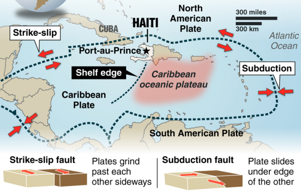
Bronquote:Seven quakes have rocked Caribbean islands as of Saturday and another tremor occurred in Haiti this Monday, raising concern among experts about a likely seismic reactivation in the area. “For some days we have observed an unusual activity that seems to be linked to the subduction of the Caribbean tectonic plate,” Saint Lucian seismologist Bruce Kleever told Prensa Latina. Seven tremors were felt in the British overseas territories in East Caribbean over the weekend, according to the Disaster Management Department of the Virgin Islands. “The seismic events were of 3.5-4.6 magnitude and could also be felt in Puerto Rico. We’re following closely the situation in the area,” said Kleever. A 4.3-magnitude quake rocked southern Haiti early morning today, one year, ten months and two days after the worst seism in the history of this country occurred. No damages or fatalities have been reported so far, but the people panicked as they relived the nightmare. According to the expert, the tremor might indicate an area of seismic activity also in the northern Caribbean plate. For years, the specialists have feared the likelihood of powerful quakes and ensuing tsunamis in the Caribbean because of the existence in the area of important focuses of danger of tectonic movement. One of them is located near Dominica, considered the point with the largest number of potentially active volcanoes in the world. However, Kleever said panic must not be triggered among the population. “Just remain on alert and take steps in case of any tremor,” he said. Steps include going to open, safer spaces, mainly in highlands, far from buildings. The Caribbean currently lacks a tsunami early warning system. Such a device would be likely available by year 2014. Watch over the area is carried out from the Hawaii-based Tsunami Warning Center, in the Pacific. At least 88 tsunamis have occurred in the Caribbean in the past 500 years, the worst of them in 1946, killing some 1,600 people.
quote:Earthquake
Country: Bolivia
State: Departamento del Beni
Location: Puerto Calvimonte
Date: 2011-11-22 : 18:48:15
Magnitude: 6.2
Depth: 533.30 km
bronquote:Earthquake
Country: Bolivia
State:
Location: El Carmen
Date: 2011-11-22 : 18:48:18
Magnitude: 6.6
Depth: 572 km
quote:Manipur experiences 23 minor tremors in a day
Imphal, November 22 2011: According to a reports of the Seismological Observatory, Manipur University, Manipur experiences at least 23 minor tremors in a day but these tremors could not be felt by the people, Director of College Development Council, Manipur University Dr RK Ranjan has disclosed.
He was speaking as Chief Guest of the inaugural function of a 5-day long NSS Mega Festival at Youth Hostel No.3, Khuman Lampak Sports Complex.
The camp is being organized under the aegis of State National Service Scheme (NSS) Cell.
Dr Ranjan informed that these minor tremors could be detected only by earthquake monitoring equipments.
Some experts opined that such repetitive minor tremors is an indication that no major quake would occurred in Manipur while others maintained that these minor tremors are only regrouping of the elements that would ultimately erupted into a devastating quake sooner or later.
In spite of contrasting views, one thing is certain that the land mass of Manipur has been formed along the fold lines that have no joining between one fold and another.
There is one large fold line running from Mao to Churachandpur and this would pose greater risk in the event of a major earthquake and this could happen at any time.
So, there is the need to step up the activities of Disaster Management in Manipur, Dr Ranjan said.

Gaat nog steeds lekker daar...
en ook:quote:BreakingNews Breaking News
Report of 6.1 magnitude earthquake off the coast of Japan - @@W7VOA, @earthquake_jp (translated) bit.ly/vMDze7
3 minutes ago Favorite Retweet Reply
quote:BreakingNews Breaking News
More: Earthquake epicenter off coast of Fukishima, Japan, felt in Tokyo; no tsunami alert posted - @HirokoTabuchi, @W7VOA
48 seconds ago Favorite Retweet Reply
I give myself very good advice
But I very seldom follow it
That explains the trouble that I'm always in
But I very seldom follow it
That explains the trouble that I'm always in
In navolging van het bericht hierboven op 16 november

Doomsday optelsom... fictie... of wordt het straks een nachtmerrie?quote:Volcanic and seismic awakening of Pan-America
The seismic and volcanic awakening of Pan-America is now well underway. The Caribbean Plate comprises an area of roughly 3.2 million square km (1.2 million square miles) and it is undergoing major stress. A series of seismic swarms in this region resulted in the outbreak of a 5.1 magnitude earthquake which struck off the coast of San Juan Puerto Rico this week. The northern boundary of the Caribbean Plate with the North American plate is a transform or strike-slip boundary which runs from the border area of Belize, Guatemala (Motagua Fault), and Honduras in Central America, eastward through the Cayman trough on south of the southeast coast of Cuba, and just north of Hispaniola, Puerto Rico, and the Virgin Islands. Part of the Puerto Rico Trench, the deepest part of the Atlantic Ocean (roughly 8,400 meters), also lies along this border. The Puerto Rico trench is at a complex transition from the subduction boundary to the south and the transform boundary to the west. The Cocos plate on the western border of Pan America is subducting under the Caribbean Plate.
The whole region is becoming more violent as geological forces increase plate pressures on the region and the sea-floor is violently stirred along the Puerto Rico trench. The trench has an unsettling history of producing very powerful earthquakes- 8.1 magnitude earthquakes struck the region both in 1787 and 1946. In light of the rising earthquake risks, UNESCO conducted a Caribbean Tsunami warning exercise on March 23, 2011 in anticipation of a 7.6 magnitude earthquake. It goes without saying, we’re overdue for another major earthquake to strike this region.
As a result of the mounting seismic tension on the western region of the plate, we’re already witnessing the volcanic and seismic awakening of much of Pan-America. On November 20, Mexico’s Popocatepetl volcano unleashed a 5 km ash cloud. On November 22nd, Guatemala’s lofty Fuego volcano followed suit with a 2 km cloud of dark ash. On November 25th, the alert status of Colombia’s Gelaras volcano was raised to orange. On November 26th, the dense upper volcanic belt of El Salvador was shaken by a swarm of over 700 tremors in a 24-hour-period. Now Ecuador’s Tungurahua volcano is the latest telltale sign that the time-bomb in the Atlanic is still ticking.
Nog maar even een optelsom...
Volgens de OP... gemiddeld 20 aardbevingen van 7.0-7.9 per jaar
Waar zitten we nu op?
Januari 4
Februari 0
Maart 1
April 2
Mei 0
Juni 1
Juli 2
Augustus 2
September 2
Oktober 2
November 0
totaal nu 16... gemiddeld genomen nog 4 te gaan in de laatste maand...
Gemiddeld komen er 2 bevingen 8.0 of hoger voor per jaar. Tot nu toe hebben we er één gehad.
December kan een zware maand wordt als moeder aarde zich aan het gemiddelde houdt...
Frutsel, de vorige keer toen je zoiets postte was het toch vrij snel raak?  . Als dat nu weer het geval is, verbied ik je nog dat soort dingen te posten

 Op
Op
quote:Ramen sneuvelen bij aardbeving NieuwZeeland
Een aardbeving met een kracht van 5,7 op de schaal van Richter in het noorden van het zuidelijke eiland van Nieuw-Zeeland heeft zaterdag ramen doen sneuvelen in de hoofdstad Wellington.
Er is geen grote schade gemeld, maar volgens een radiozender sneuvelden ramen van een kantoorgebouw in Wellington. Inwoners zagen ook spullen van kasten vallen.
Volgens seismologen lag het epicentrum van de aardbeving 40 kilometer ten westen van Wellington op 60 kilometer diepte. Het zou gaan om de zwaarste aardbeving in de regio sinds 45 jaar. (afp/mvl)
Die bevingen komen dagelijks voor... dus daar is niets raars aan... en ik heb niets voorspeld, alleen dat we vier 7+ bevingen "missen"... en iemand zei dat de laatste keren dat ik zoiets zei het direct raak was

Tja geen idee maarrrrr:quote:
quote:Baja California (Nederlands: Neder-Californië) is een deelstaat van Mexico. De staat ligt op het noordelijk deel van het schiereiland Neder-Californië. Als enige Mexicaanse staat ligt Baja California in de tijdzone UTC-8.
En een provincie Limburg.quote:Op zondag 4 december 2011 17:52 schreef Prego het volgende:
[..]
zeeuws vlaanderen hoort bij nederland en belgië heeft ook een provincie die brabant heet.
Your wish is my command... nu is het zeker Mexico.quote:
Mexico opgeschrikt door krachtige aardbeving

http://earthquake.usgs.go(...)c000753u.php#detailsquote:Earthquake Details
This event has been reviewed by a seismologist.
Magnitude 6.5
Date-Time
Sunday, December 11, 2011 at 01:47:26 UTC
Saturday, December 10, 2011 at 07:47:26 PM at epicenter
Time of Earthquake in other Time Zones
Location 18.038°N, 99.796°W
Depth 64.9 km (40.3 miles)
Region GUERRERO, MEXICO
Distances 42 km (26 miles) SW of Iguala, Guerrero, Mexico
56 km (34 miles) ESE of Arcelia, Guerrero, Mexico
62 km (38 miles) NNW of Chilpancingo, Guerrero, Mexico
166 km (103 miles) SSW of MEXICO CITY, D.F., Mexico
Location Uncertainty horizontal +/- 14.5 km (9.0 miles); depth +/- 9.8 km (6.1 miles)
Als het niet met een hamer te repareren is, is het een elektrisch probleem.
quote:'Cycloon veroorzaakt binnen 4 jaar aardbeving'
Amerikaanse wetenschappers zeggen dat ze bewijs hebben gevonden dat tropische regenstormen worden gevolgd door aardbevingen. Ze suggereren dat de zware regenbuien binnen 4 jaar bevingen veroorzaken.
Onderzoekers van de universiteit van Miami bekeken cyclonen en aardbevingen in Haïti en Taiwan.
'Zware neerslag zorgt voor duizenden aardverschuivingen. De erosie verwijdert grondmateriaal van het oppervlak, wat allerlei bewegingen langs breuklijnen veroorzaakt', zei Shimon Wdowinski, professor of zeegeologie en geofysica donderdag op een congres van de American Geophysical Society in San Francisco.


quote:Op zondag 11 december 2011 08:59 schreef Resistor het volgende:
[..]
Your wish is my command... nu is het zeker Mexico.
Mexico opgeschrikt door krachtige aardbeving
[ afbeelding ]
[..]
http://earthquake.usgs.go(...)c000753u.php#details
The only limit is your own imagination
Ik ben niet gelovig aangelegd en maak daarin geen onderscheid tussen dominees, imams, scharenslieps, autohandelaren, politici en massamedia
Waarom er geen vliegtuig in het WTC vloog
Ik ben niet gelovig aangelegd en maak daarin geen onderscheid tussen dominees, imams, scharenslieps, autohandelaren, politici en massamedia
Waarom er geen vliegtuig in het WTC vloog

Voorschok voor één van de 3 missende 7+ quakesquote:3.6 jolts greater LA area
A magnitude 3.6 earthquake shook the greater Los Angeles area early on Tuesday morning; there are no reports of any damage.
The quake struck at 12:32 a.m. local time, and was centered about 38 miles east of downtown Los Angeles near Ontario, Calif.
According to the USGS, the greatest tremors were felt from the Eastside of L.A. through the western part of the Inland Empire, including in Riverside and Rancho Cucamonga.
Though no damage has been reported, the shaking may have been more severe than what is typical for a magnitude 3.6 quake in this area since it was centered only a mile deep.
Numerous people took to Twitter to report the earthquake.
Curiously enough, the epicenter was displaced from the San Andreas fault, the typical focus for earthquakes in California.
Zou dat nog iets impliceren of is 't een onbeduidende toevalligheid?quote:Curiously enough, the epicenter was displaced from the San Andreas fault, the typical focus for earthquakes in California.
And what rough beast, its hour come round at last,
Slouches towards Bethlehem to be born?
Slouches towards Bethlehem to be born?
wederom zware schokken in Christchurch....5.8
http://www.geonet.org.nz/earthquake/quakes/3631359g.html
http://www.geonet.org.nz/earthquake/quakes/3631359g.html
'Lopen is geen sport maar een manier van reizen'
'Als ik loop voel ik me beroerd, maar als ik niet loop nog beroerder'
'Once you discover the rewards of pain, you want more pain'
'Als ik loop voel ik me beroerd, maar als ik niet loop nog beroerder'
'Once you discover the rewards of pain, you want more pain'

Twee zware aardbevingen in Nieuw-Zeeland
CHRISTCHURCH - Bij de grote Nieuw-Zeelandse stad Christchurch hebben zich vrijdag twee krachtige aardbevingen voorgedaan.
De bevingen had elk een kracht van 5,8 op de schaal van Richter, meldde het Amerikaanse geologische centrum USGS. De tweede schok volgde 70 minuten na de eerste.
De stad werd 10 maanden geleden getroffen door een beving met een kracht van 6,3. Daarbij vielen circa 180 doden.
Een groot deel van het stadscentrum was toen ingestort, een schadepost van circa 9 miljard euro.
Paniek
Na de nieuwe schokken ontstond paniek onder inwoners. Meerdere winkelcentra, kantoren en andere gebouwen werden geëvacueerd.
In enkele buurten zijn de stroom en telefoon uitgevallen. Vooralsnog zijn er alleen berichten over lichtgewonden. De schade lijkt beperkt tot omgevallen spullen en wat barsten in de muren van het casino.
Instorten
''Het hele gebouw schudde. Ik was bang dat het zou instorten'', zei Daniel Yeoh, die aan het lunchen was in een Thais restaurant, tegenover het casino.
''Het was ongelooflijk krachtig'', zei een bewoner van het gebied tegen Radio New Zealand. ''Allerlei spullen zijn op de vloer gevallen, een beetje gebroken glas en fotolijstjes liggen overal.''
Nieuw-Zeeland wordt vaak getroffen door aardbevingen.
nu.nl
toestand wat betreft schade etc. valt gelukkig erg mee... maar ja, nu maar afwachten of er tijdens de kerstdagen niet al te veel naschokken komen.quote:
Gvd, houdt t daar dan nooit op?Het was al zo'n bende...
Het grote probleem is dat mensen er langzamerhand geestelijk aan onderdoor gaan,steeds maar weer naschokken.... want dit duurt nu al bijna 15 maanden
'Lopen is geen sport maar een manier van reizen'
'Als ik loop voel ik me beroerd, maar als ik niet loop nog beroerder'
'Once you discover the rewards of pain, you want more pain'
'Als ik loop voel ik me beroerd, maar als ik niet loop nog beroerder'
'Once you discover the rewards of pain, you want more pain'
Nou, infrastructuur is wel weer verder beschadigd en van de cathedral blijft ook steeds minder over.quote:
[..]
toestand wat betreft schade etc. valt gelukkig erg mee... maar ja, nu maar afwachten of er tijdens de kerstdagen niet al te veel naschokken komen.
Het grote probleem is dat mensen er langzamerhand geestelijk aan onderdoor gaan,steeds maar weer naschokken.... want dit duurt nu al bijna 15 maanden
En inderdaad de naschokken.... Zo kut is dat... Zo maar eens een mailtje die kant opgooien hoe het is..
schade aan de infrastructuur lijkt mee te vallen...wel hoop huizen zonder stroom maar dat blijkt meer een kwestie van "tripping' te zijn i.p.v. daadwerkelijke schade aan het netwerk.quote:
[..]
Nou, infrastructuur is wel weer verder beschadigd en van de cathedral blijft ook steeds minder over.
En inderdaad de naschokken.... Zo kut is dat... Zo maar eens een mailtje die kant opgooien hoe het is..
'Lopen is geen sport maar een manier van reizen'
'Als ik loop voel ik me beroerd, maar als ik niet loop nog beroerder'
'Once you discover the rewards of pain, you want more pain'
'Als ik loop voel ik me beroerd, maar als ik niet loop nog beroerder'
'Once you discover the rewards of pain, you want more pain'
Ja, had ik ook gelezen ja. Gelukkig maar. Wel weer hier en daar wat liquefaction. Geeft ook een bende en gaten in de wegen.quote:
[..]
schade aan de infrastructuur lijkt mee te vallen...wel hoop huizen zonder stroom maar dat blijkt meer een kwestie van "tripping' te zijn i.p.v. daadwerkelijke schade aan het netwerk.
Hopelijk wordt t snel wat rustiger.
het heeft de hele nacht flink door gerommelt
http://www.geonet.org.nz/earthquake/quakes/recent_quakes.html
Kia Kaha CHCH !!
http://www.geonet.org.nz/earthquake/quakes/recent_quakes.html
Kia Kaha CHCH !!
'Lopen is geen sport maar een manier van reizen'
'Als ik loop voel ik me beroerd, maar als ik niet loop nog beroerder'
'Once you discover the rewards of pain, you want more pain'
'Als ik loop voel ik me beroerd, maar als ik niet loop nog beroerder'
'Once you discover the rewards of pain, you want more pain'
quote:Quake rattles New Zealand's Christchurch
Dec 31 (Reuters) - An earthquake with a magnitude of 5.3 struck close to the New Zealand city of Christchurch on Saturday, the U.S. Geological Survey reported, but there were no immediate reports of damage or casualties.
The quake was measured only about 14 km (9 miles) northeast of the city. It was another in a series of quakes that have rattled the city since a major earthquake killed almost 200 people there 10 months ago.
There were no immediate reports of a tsunami warning.
A quake of a similar magnitude was felt in the area on Dec. 23, sending terrified residents from their houses but causing no casualties or major damage.
Christchurch, the largest city in New Zealand's South Island, is still recovering from a quake measuring 6.3 that killed 182 people in February and caused up to NZ$20 billion ($15.5 billion) in damage.
Large areas of Christchurch's business district are still off limits after the February quake, which toppled the city's famous cathedral, as well as shops, office buildings and homes.
New Zealand straddles the boundaries of the Indo-Australian and the Pacific tectonic plates and is hit by about 14,000 quakes every year, of which only a small number top a magnitude of 5.
En ook in t nieuwe jaar rommelt t gewoon door in christchurch
En Japan ook weer trouwens. Hopelijk kan t alleen maar minder worden dat geschud. Ik hoop het voor ze, maar dat zal wel niet.
En Japan ook weer trouwens. Hopelijk kan t alleen maar minder worden dat geschud. Ik hoop het voor ze, maar dat zal wel niet.
ook vannacht weer een 5.5quote:
En ook in t nieuwe jaar rommelt t gewoon door in christchurch
En Japan ook weer trouwens. Hopelijk kan t alleen maar minder worden dat geschud. Ik hoop het voor ze, maar dat zal wel niet.
'Lopen is geen sport maar een manier van reizen'
'Als ik loop voel ik me beroerd, maar als ik niet loop nog beroerder'
'Once you discover the rewards of pain, you want more pain'
'Als ik loop voel ik me beroerd, maar als ik niet loop nog beroerder'
'Once you discover the rewards of pain, you want more pain'
Ja, meerdere shakes weer geweest en heel wat huishoudens zonder stroom. Ik had zo voor de mensen daar gehoopt dat 2012 wat rustiger zou beginnen.
Nu ruim 10 maanden geleden dat alles daar helemaal compleet instortte (voorafgegaan door wat minder grote schadequakes)
Nu ruim 10 maanden geleden dat alles daar helemaal compleet instortte (voorafgegaan door wat minder grote schadequakes)
Inmiddels gedowngrade naar 6.8?quote:
Ik hoorde net op de radio zware aardbeving Japan. 2012 is begonnen :S
Ik dacht dat het een 7+ was... maar goed, het één en ander gemist deze week .
Plus dat januari 2011 ook met vier bevingen van 7 of hoger begon... deze dus een 6.8
quote:17 aardbevingen in 18 uur tijd voor Christchurch
De Nieuw-Zeelandse stad Christchurch is op 18 uur tijd 17 keer door elkaar geschud door aardbevingen. Er is voorlopig geen sprake van grote schade.
Christchurch, de grootste stad van het zuidereiland, wordt al sinds september 2010 geteisterd door aardbevingen. Bij de beving in februari vorig jaar vielen nog 181 doden.
Onder de bevingen van vandaag waren er twee sterker dan 5 op de schaal van Richter.
De stad vraagt in een mededeling aan de inwoners om "te zorgen voor vrienden, buren en familie in deze moeilijke tijden". Burgemeester Bob Parker verzekerde dat de stad er alles aan doet om de belangrijkste diensten operationeel te houden. (dpa/adha)
Bleh, je zult daar maar wonen. 
And what rough beast, its hour come round at last,
Slouches towards Bethlehem to be born?
Slouches towards Bethlehem to be born?

Gaat ook goed bij Tenerife
5 bevingen (niet al te zwaar) op een rechte lijn.
[ Bericht 23% gewijzigd door bwt op 05-01-2012 17:07:02 ]
5 bevingen (niet al te zwaar) op een rechte lijn.

quote:And are today, January 5, five sismitos around Tenerife, one of Puerto NW, about 11 km from the coast, and the other 4 SE of Candelaria, in a straight line, the farthest about 12 '5 km and the closest to a 4,5 km from the coast, in between the other two, closer, about 6km, and very close together. The size of each map. (Humberto)

quote:Update 05/01 15:22 UTC
- A very curious pattern in GPS deformation patterns (the data which are published are probably 2 days old). The deformation at HI02, HI03 and HI04 climbed strongly ! La Palma deformation stayed approx. the same, but Tenerife and La Gomera GPS data decreased the strongest since the beginning of El Hierro activity. The current earthquakes at Tenerife may have an origin in this strong deflation (tension). The smoking lava Yesterday and Today also. @ IGN to solve the clue here. Hopefully they will explain in their report later today.
quote:There seems to be moving in the Border GPS station in the last two days, in every season reflects a movement that has similar characteristics and should be monitored to see if it continues the next day.
Comparing the data of IGN compared to other stations of Frontera, it's like Frontera station was moving to the east, as there is no relative motion with respect to NS Palma and a movement of approach compared to the Tenerife. HI02, HI03 and HI04 seem to have the same pattern of separation.
As for the vertical deformation .... will have to wait to see part of IGN happens, but if some do not move and goes to the East border, depart hence, it is conceivable that there should be an inflation (Enrique) .
[bron]
[ Bericht 23% gewijzigd door bwt op 05-01-2012 17:07:02 ]
<a href="http://goo.gl/q8fhTe" target="_blank">FAQ?</a>
<a href="http://goo.gl/gYvZFq" target="_blank">Geel is een zonnige en vrolijke kleur, als hij tenminste enigszins warm is gekleurd en wat naar het oranje neigt</a>
<a href="http://goo.gl/gYvZFq" target="_blank">Geel is een zonnige en vrolijke kleur, als hij tenminste enigszins warm is gekleurd en wat naar het oranje neigt</a>
quote:4,5 quake rattles Christchurch
At 1:21 a.m. local time (7:21 a.m. Eastern), a 4.5-magnitude earthquake struck New Zealand, roughly 25 kilometers east of Cristchurch. It originated from approximately 6.2 miles below the surface.
The area is not a stranger to earthquakes, as they were hit by a 5.8-magnitude tremor just two days before Christmas. There were thousands of recorded aftershocks following a 7.0-magnitude quake that struck on Sept. 4, 2010. Amazingly, no deaths resulted from that earthquake.
There have been no reports of injuries or damage from this earthquake, but we will keep you updated as details roll in.

quote:MAP 4.5 2012/01/06 12:21:35 -43.547 172.982 9.9 SOUTH ISLAND OF NEW ZEALAND
MAP 4.7 2012/01/06 07:04:16 -43.508 172.825 11.3 SOUTH ISLAND OF NEW ZEALAND
MAP 4.5 2012/01/06 01:20:57 -43.481 172.913 8.4 SOUTH ISLAND OF NEW ZEALAND
MAP 4.5 2012/01/02 05:59:14 -43.453 172.897 13.2 SOUTH ISLAND OF NEW ZEALAND
MAP 5.2 2012/01/01 16:45:04 -43.428 172.892 10.6 SOUTH ISLAND OF NEW ZEALAND
MAP 5.0 2012/01/01 12:27:56 -43.472 172.952 13.8 SOUTH ISLAND OF NEW ZEALAND
MAP 5.3 2011/12/31 00:44:46 -43.484 172.823 10.1 SOUTH ISLAND OF NEW ZEALAND
quote:6.6 Quake strikes off the Santa Cruz Islands
LATA, SOLOMON ISLANDS (BNO NEWS) -- A strong earthquake struck off the Santa Cruz Islands in the Pacific Ocean on late Monday afternoon, seismologists said, but there were no immediate reports of damage or casualties.
The 6.6-magnitude earthquake at 3:07 p.m. local time (0407 GMT) was centered about 75 kilometers (46 miles) west-northwest of Lata, the provincial capital of Temotu Province on Nendo island, which is part of the Santa Cruz Islands in the Solomon Islands. It struck about 38.9 kilometers (24.2 miles) deep, making it a shallow earthquake, according to the United States Geological Survey (USGS).
The USGS estimated that approximately 14,000 people on islands in the region may have felt strong shaking, which would be unlikely to result in serious damage or casualties. Tens of thousands more may have felt weak to moderate shaking, but there were no initial reports of damage.
Both the Pacific Tsunami Warning Center (PTWC) and the Joint Australian Tsunami Warning Center (JATWC) said there was no threat of a tsunami. "No destructive widespread tsunami threat exists based on historical earthquake and tsunami data," PTWC said in a bulletin.
The Solomon Islands are on the so-called 'Pacific Ring of Fire', an arc of fault lines circling the Pacific Basin that is prone to frequent and large earthquakes. Volcanic eruptions also occur frequently in the region.
The Solomon Islands arc as a whole experiences a very high level of earthquake activity, and many tremors of magnitude 7 and larger have been recorded since the early decades of the twentieth century.
On April 2, 2007, a massive 8.1-magnitude earthquake struck close to the New Georgia Islands of the Solomon Islands. It unleashed a regional tsunami, killing 52 people and destroying more than 300 homes, schools and a hospital at Sasamunga. Two people were killed as a result of landslides, which were triggered by the earthquake

http://earthquake.usgs.go(...)uakes/usc0007ir5.php
Depth: 29.1 km (18.1 miles)
De tsunami-voorspelling is gelukkig vrij gunstig zo te lezen:
Depth: 29.1 km (18.1 miles)
De tsunami-voorspelling is gelukkig vrij gunstig zo te lezen:
http://ptwc.weather.gov/p(...)BIOX.2012.01.10.1845quote:EVALUATION
A DESTRUCTIVE WIDESPREAD TSUNAMI THREAT DOES NOT EXIST BASED ON
HISTORICAL EARTHQUAKE AND TSUNAMI DATA.
HOWEVER - THERE IS A VERY SMALL POSSIBILITY OF A LOCAL TSUNAMI
THAT COULD AFFECT COASTS LOCATED USUALLY NO MORE THAN A HUNDRED
KILOMETERS FROM THE EARTHQUAKE EPICENTER. AUTHORITIES IN THE
REGION NEAR THE EPICENTER SHOULD BE MADE AWARE OF THIS
POSSIBILITY.
And what rough beast, its hour come round at last,
Slouches towards Bethlehem to be born?
Slouches towards Bethlehem to be born?
Het gaat allemaal weer lekker te keer, ben benieuwd wat we dit jaar weer gaan krijgen, LA aan de beurt?
Doe mee met het voorspellen van het weer!
Weekvoorspelling | Week 12 (invullen tot 16-03 - 11:59)
Maandvoorspelling Maart (Inzendingen gesloten)
Jaarvoorspelling 2025 / 2026
Weekvoorspelling | Week 12 (invullen tot 16-03 - 11:59)
Maandvoorspelling Maart (Inzendingen gesloten)
Jaarvoorspelling 2025 / 2026
Mag wel eens tijd wordenquote:
Het gaat allemaal weer lekker te keer, ben benieuwd wat we dit jaar weer gaan krijgen, LA aan de beurt?
Ik hoop het niet. Bij elke aardbeving schudden er namelijk dozijnen 2012 believers en trollen onder hun stenen vandaan. Gek wordt je ervan.
Opgeblazen gevoel of winderigheid? Zo opgelost met Rennie!
Seismic server flipt de pan uit:
Nog veel meer locaties.... zie:
http://earthquake.usgs.go(...)ns/heliplots_gsn.php
[ Bericht 7% gewijzigd door #ANONIEM op 11-01-2012 00:52:15 ]

Nog veel meer locaties.... zie:
http://earthquake.usgs.go(...)ns/heliplots_gsn.php
[ Bericht 7% gewijzigd door #ANONIEM op 11-01-2012 00:52:15 ]

wat betekend dit?quote:
Seismic server flipt de pan uit:
[ afbeelding ]
Nog veel meer locaties.... zie:
http://earthquake.usgs.go(...)ns/heliplots_gsn.php
Herman Finkers... He buurman, ik hier ?
 Op
Op
Dan zou je iig niet in Brazillië willen zittenquote:
Seismic server flipt de pan uit:
[ afbeelding ]
Nog veel meer locaties.... zie:
http://earthquake.usgs.go(...)ns/heliplots_gsn.php
*zet alvast alu-2012-hoedje op


Lijkt gelukkig te ver weg voor aanzienlijke schade, maar een 6.1 is voor Nieuw Zeelanders toch altijd schrikken nu.
Zie ook
Theorie: Aardbevingen Christchurch voortekenen van vulkaanuitbarsting?
quote:Magnitude mb 5.4
Region NORTHEASTERN IRAN
Date time 2012-01-19 12:35:52.0 UTC
Location 36.49 N ; 59.06 E
Depth 10 km
Distances 37 km NE Neyshabur (pop 220,929 ; local time 16:05:52.0 2012-01-19)
18 km S Chenaran (pop 46,940 ; local time 16:05:52.0 2012-01-19)

quote:Series of quakes strike North Island
A flurry of small earthquakes has rattled the North Island this morning.
Two early-morning quakes rumbled under Taupo in the wee hours, both at relatively shallow depths.
The first, at 3.07am, measured magnitude 2.9 and hit at a depth of 5km, 10km west of Taupo.
The second, in the same place but at a depth of 2km and measuring 2.4, hit at 4.55am.
Both were felt by Taupo residents, Geonet reported.
Two slightly larger quakes hit Napier and Hastings later in the morning, with the largest measuring 4.3.
The quake was centred 30km southeast of Hastings at a depth of 30km, and hit at 8.49am.
Geonet reported the quake was felt as far south as Waipakurau.
A 3.3 quake was reported just two minutes earlier, at a depth of 20 km, 20km south of Hastings.
There were no reports of damage.
quote:Christchurch rumbled by series of quakes
A 24-hour period without earthquakes ended for Christchurch residents with a 3.7, a 4.5 and then a 4.0-magnitude tremor this morning.
The 3.7-magnitude quake, which struck shortly before 3am, was centred 10 kilometres east of Christchurch at a depth of 10km.
The 4.5-magnitude quake struck at 6.46am, centred 20km east of Christchurch at a depth of 12km, while the 4.0-magnitude shake struck just after 8.30am, centred 20km west of Christchurch and 9km deep.
The continued shaking comes as the city's business leaders call for urgent decisions to be made on the siting of Christchurch's new convention centre and the future of AMI Stadium.
Canterbury Employers' Chamber of Commerce chief executive Peter Townsend said authorities could not afford to dally over positioning of infrastructure assets such as the convention centre because it was critical to determining where other developments would go.
"The centre's siting and AMI Stadium are key decisions required immediately," he said.
"They are critical to what will happen in a lot of the rest of the city."
Demolition of the city's quake-damaged convention centre started last week.
The city council plans to build a $200 million replacement but has yet to confirm where it will be built.
quote:75% chance of a 7+ quake hitting Tokyo within 4 years
A big earthquake is much more likely to hit the Japanese capital, Tokyo, in the next few years than the government has predicted, researchers say.
The team, from the University of Tokyo, said there was a 75% probability that a magnitude 7 quake would strike the region in the next four years.
The government says the chances of such an event are 70% in the next 30 years.
The warning comes less than a year after a massive earthquake and tsunami devastated Japan's north-eastern coast.
The last time Tokyo was hit by a big earthquake was in 1923, when a 7.9 magnitude quake killed more than 100,000 people, many of them in fires.
Researchers at the University of Tokyo's earthquake research institute based their figures on data from the growing number of tremors in the capital since the 11 March 2011 quake.
They say that compared with normal years, there has been a five-fold increase in the number of quakes in the Tokyo metropolitan area since the March disaster.
They based their calculations on data from Japan's Meteorological Agency, They said their results show that seismic activity had increased in the area around the capital, which in turn leads to a higher probability of a major quake.
The researchers say that while it is "hard to predict" the casualty impact of a major quake on Tokyo, the government and individuals should be prepared for it.
Correspondents say that while the university calculations take account of greater seismic activity since March, government calculations may use different or less up-to-date data and different modelling techniques.
The 9.0 magnitude earthquake last year aksi crippled the cooling systems at the Fukushima nuclear power station, causing meltdowns in some of its reactors.
Japan is located on a tectonic crossroads dubbed the "Pacific Ring of Fire" which is why its is commonly regarded as one of the world's most quake-prone countries, with Tokyo located in one of the most dangerous areas.

Flinke beving in Italy... 5.1
Deed me ff denken aan L'Aquila uit 2009 maar die was denk ik 6.0 ofzo
Hopelijk valt hier de schade mee
quote:Noord-italie opgeschrikt door aardbeving
Het noorden van Italië is vanmorgen opgeschrikt door een aardbeving. In Milaan liepen veel mensen ongerust de straat op. In gebouwen vielen allerlei voorwerpen, maar er zijn geen berichten over doden of gewonden. Dat hebben Italiaanse media gemeld.
De krachtigste aardbeving - 4,9 op de schaal van Richter - vond volgens het nationaal geofysisch instituut rond 9 uur plaats. Het epicentrum van die beving bevond zich nabij de stad Reggio Emilia, in de regio Emilia-Romagna. Ook in Milaan, de op een na grootste stad van het land, was de schok voelbaar. De aardschokken zijn gevoeld in de regio's Lombardije, Emilia-Romagna, Veneto en Piemonte.
Vannacht had zich al een aardbeving met een kracht van 4,2 op de schaal van Richter voorgedaan in de buurt van Verona, gevold door een naschok met een magnitude van 2,9.
Grote delen van Italië zijn seismisch actief gebied. Bij de aardbeving in L'Aquila in 2009 vielen meer dan 300 doden. In december 1908 vielen in Sicilië en Calabrië ongeveer 100.000 doden door verwoestende aardschokken. (belga/adha/sg)

KSC JUBILEUM topic
"Sleep: A completely inadequate substitute for caffeine"
#TeamHumbug
Heeft patent op Mosterd-Maaltijd situaties
"Sleep: A completely inadequate substitute for caffeine"
#TeamHumbug
Heeft patent op Mosterd-Maaltijd situaties

KSC JUBILEUM topic
"Sleep: A completely inadequate substitute for caffeine"
#TeamHumbug
Heeft patent op Mosterd-Maaltijd situaties
"Sleep: A completely inadequate substitute for caffeine"
#TeamHumbug
Heeft patent op Mosterd-Maaltijd situaties
quote:
 Op
Op quote:125 injuries in Peru after quake
Update 21:15UTC: 125 people are reported to be injured (108 from the province of Ica (of which 73 from Dist. Ica, 6 from the Dist. Ocucaje, 10 from Dist. Parcona, 1 from Dist. Santiago, 6 from Dist. Tinguina, 10 from Dist. Guadalupe); 12 from the province of Pisco; 7 from the province of Chincha).
140 people are homeless of which 115 are in the Province of Ica and 25 from the Province of Pisco.
28 houses are uninhabitable (23 in Ica, 5 in Pisco) and 27 additional houses are damaged.
The 125 injured have been serviced and taken care of at local hospitals and health centers.
Earthquake-report.com commends INDECI for their speedy and also intensive and detailed work in collecting the damage statistics. A lot of much more developed nations could learn much from the Peruvian press reporting of disasters.

MAP 5.3 2012/02/02 13:57:07 -17.462 167.169 10.0 VANUATU
MAP 4.9 2012/02/02 13:53:45 -17.597 167.191 13.4 VANUATU
MAP 6.9 2012/02/02 13:34:38 -17.810 167.149 10.1 VANUATU
MAP 4.9 2012/02/02 13:53:45 -17.597 167.191 13.4 VANUATU
MAP 6.9 2012/02/02 13:34:38 -17.810 167.149 10.1 VANUATU
Vanuatu opgewaardeerd naar 7.1
Aardig lijstje wordt het alweer.
Aardig lijstje wordt het alweer.
quote:MAP 4.9 2012/02/03 08:13:17 -17.953 167.817 18.5 VANUATU
MAP 5.7 2012/02/03 06:01:41 -17.380 167.183 24.9 VANUATU
MAP 5.4 2012/02/03 04:33:09 -17.484 167.232 23.8 VANUATU
MAP 6.0 2012/02/03 03:46:23 -17.376 167.278 21.7 VANUATU
MAP 4.8 2012/02/02 21:47:52 -17.523 167.235 9.9 VANUATU
MAP 5.1 2012/02/02 20:26:31 -17.519 167.359 17.4 VANUATU
MAP 5.1 2012/02/02 19:44:35 -17.457 167.229 31.9 VANUATU
MAP 4.9 2012/02/02 19:20:45 -17.996 167.828 10.3 VANUATU
MAP 5.2 2012/02/02 17:28:47 -17.596 167.339 20.8 VANUATU
MAP 5.5 2012/02/02 17:27:07 -17.963 167.209 22.8 VANUATU
MAP 5.0 2012/02/02 16:04:45 -17.779 167.233 33.3 VANUATU
MAP 5.3 2012/02/02 13:57:07 -17.462 167.169 10.0 VANUATU
MAP 4.9 2012/02/02 13:53:45 -17.597 167.191 13.4 VANUATU
MAP 7.1 2012/02/02 13:34:40 -17.766 167.134 23.1 VANUATU

quote:At least 13 killed in 6.8 quake
MANILA, Philippines (AP) -- A strong earthquake in the central Philippines killed at least 13 people Monday as it destroyed buildings and triggered landslides that buried dozens of houses, trapping residents. At least 29 people were missing.
The 6.8-magnitude quake, in a narrow strait just off Negros Island, caused a landslide in Guihulngan, a city of about 180,000 people in Negros Oriental province. As many as 30 houses were buried and at least 29 people were missing, Mayor Ernesto Reyes said.
"Their situation is bad because if you are covered by landslide for one hour, two hours, how can you breathe?" he said. "But we just hope for the best, that there are still survivors."
Rescuers were using picks and shovels to dig for survivors, he said.
Reyes said at least 10 people were confirmed dead in his town, including students at a college and an elementary school and others in a market that collapsed. About 100 were injured.
The quake, which hit at 11:49 a.m. (0349 GMT), triggered another landslide in the mountain village of Solongon in La Libertad town, also in Negros Oriental. An unknown number of people were trapped, said La Libertad police chief inspector Eric Arrol Besario.
"We're now getting shovels and chain saws to start a rescue because there were people trapped inside. Some of them were yelling for help earlier," Besario told The Associated Press by phone. Three key bridges in the town suffered cracks and were no longer passable, he said.
Philippine seismologists briefly issued a tsunami alert for the central islands. Five bamboo and wooden cottages were washed out from a beach resort in La Libertad by huge waves, but there were no reports of injuries, said police Superintendent Ernesto Tagle. Elsewhere along the coast, people rushed out of schools, malls and offices.
The epicenter was closest to Tayasan, a coastal town of about 32,000 people flanked by mountains in Negros Oriental province. Two died there, including a child when a concrete fence of a house collapsed, said Benito Ramos, head of the Office of Civil Defense.
Another child was killed in a church when a wall collapsed during a funeral in Negros Oriental's Jimalalud town, Mayor Reynaldo Tuanda said.
Tayasan police officer Alfred Vicente Silvosa told The AP by phone that aftershocks were preventing people from returning to their homes. Seismologists recorded nearly 45 aftershocks.
"We are outside, at the town plaza. We cannot inspect buildings yet because it's dangerous," Silvosa said. "I felt the building shaking, so I rushed out of the building. Our computers, shelves, plates, the cupboards, water dispenser all fell."
A three-story office building also collapsed in La Libertad, but occupants managed to run out.
Negros Oriental police chief Edward Carranza said the temblor damaged many houses in Guihulngan and he ordered his men to help displaced residents find shelter.
Officials in some areas suspended work and canceled classes. Power and telecommunications were knocked out in several places.
Carranza said police rushed out of his building when the quake struck. "All my personnel ran out fearing our building would collapse," he said.
"Now it's shaking again," he said as an aftershock hit. "My keychain is dancing."
The U.S. Geological Survey said the quake was centered 44 miles (72 kilometers) north of Dumaguete city on Negros and hit at a depth of 29 miles (46 kilometers). The area is about 400 miles (650 kilometers) southeast of the capital, Manila.
The Philippines is located in the Pacific "Ring of Fire" where earthquakes and volcanic activity are common. A 7.7-magnitude quake killed nearly 2,000 people in Luzon in 1990.
vlak bij mijn vakantieoord 2 jaar geleden :-)
Trouwen, in een ander topic stelde ik dat:
Trouwen, in een ander topic stelde ik dat:
Klopt dit eigenlijk wel?quote:
dat kan, aardbevingsgolven schijnen van de aardkern af te ketsen. Het hele technische verhaal heb ik zo niet bij de hand. Maar als de tijden overeen komen...
De tremors zijn wel gelijk een stuk minder geworden.... Drukopbouw?
Spannende dag voor de el hierro watchers ;-)
Inorbit: zeg dat dan typluie triangeljosti
Beauregard: Een beetje FOK!ker laat het brood door z'n moeder smeren.
Ecosia
ek's 'n flash drive, jy's 'n floppy
Beauregard: Een beetje FOK!ker laat het brood door z'n moeder smeren.
Ecosia
ek's 'n flash drive, jy's 'n floppy
KSC JUBILEUM topic
"Sleep: A completely inadequate substitute for caffeine"
#TeamHumbug
Heeft patent op Mosterd-Maaltijd situaties
"Sleep: A completely inadequate substitute for caffeine"
#TeamHumbug
Heeft patent op Mosterd-Maaltijd situaties
oh crap, das wel weer heftig...
Zijn het niet de orkanen / moesonbuien of terroristen die de buurt opschrikken zijn het wel aardbevingen...
Zijn het niet de orkanen / moesonbuien of terroristen die de buurt opschrikken zijn het wel aardbevingen...
Inorbit: zeg dat dan typluie triangeljosti
Beauregard: Een beetje FOK!ker laat het brood door z'n moeder smeren.
Ecosia
ek's 'n flash drive, jy's 'n floppy
Beauregard: Een beetje FOK!ker laat het brood door z'n moeder smeren.
Ecosia
ek's 'n flash drive, jy's 'n floppy
Live-updates van de quake op de Filipijnen
Welk deel bedoel je? Dat aardbevingsgolven van de kern afketsen?quote:
ja, dat stukjequote:
Live-updates van de quake op de Filipijnen
[..]
Welk deel bedoel je? Dat aardbevingsgolven van de kern afketsen?
Inorbit: zeg dat dan typluie triangeljosti
Beauregard: Een beetje FOK!ker laat het brood door z'n moeder smeren.
Ecosia
ek's 'n flash drive, jy's 'n floppy
Beauregard: Een beetje FOK!ker laat het brood door z'n moeder smeren.
Ecosia
ek's 'n flash drive, jy's 'n floppy
Weet alleen dat er verschillende golven bij aardbevingen vrijkomen... en afhankelijk qua diepte en qua beweging.
Wiki zegt dit erover
http://en.wikipedia.org/wiki/Seismic_wave
Wiki zegt dit erover
http://en.wikipedia.org/wiki/Seismic_wave
hmm, ja dus... maar niets over de sterkte...
Thanks fruts!
Thanks fruts!
Inorbit: zeg dat dan typluie triangeljosti
Beauregard: Een beetje FOK!ker laat het brood door z'n moeder smeren.
Ecosia
ek's 'n flash drive, jy's 'n floppy
Beauregard: Een beetje FOK!ker laat het brood door z'n moeder smeren.
Ecosia
ek's 'n flash drive, jy's 'n floppy
Rommelt flink daar zegtwitter:Kirstenmildren twitterde op maandag 06-02-2012 om 13:28:16 #Philippines Armed Forces report 46 deaths, collapse of two bridges and three-storey building, in Negros Oriental province from EQ reageer retweet

quote:MAP 5.2 2012/02/06 11:40:20 9.845 123.041 36.5 NEGROS - CEBU REGION, PHILIPPINES
MAP 6.0 2012/02/06 11:33:37 9.804 123.051 15.1 NEGROS - CEBU REGION, PHILIPPINES
MAP 6.0 2012/02/06 10:10:24 9.874 123.070 15.0 NEGROS - CEBU REGION, PHILIPPINES
MAP 5.6 2012/02/06 04:20:04 10.058 123.171 34.6 NEGROS - CEBU REGION, PHILIPPINES
MAP 6.7 2012/02/06 03:49:17 9.964 123.246 20.0 NEGROS - CEBU REGION, PHILIPPINES

naschokken hoog in de 5, tegen 6?
Krijgen we een nieuwe fukushima?
Krijgen we een nieuwe fukushima?
Inorbit: zeg dat dan typluie triangeljosti
Beauregard: Een beetje FOK!ker laat het brood door z'n moeder smeren.
Ecosia
ek's 'n flash drive, jy's 'n floppy
Beauregard: Een beetje FOK!ker laat het brood door z'n moeder smeren.
Ecosia
ek's 'n flash drive, jy's 'n floppy

quote:Dodental Filipijnen naar beneden bijgesteld
Het dodental van de aardbeving op de Filipijnen is naar beneden herzien. Volgens een nieuwe balans kwamen 26 mensen om en zijn er nog 71 vermisten. Zij liggen vermoedelijk bedolven onder het puin en de modder. Een eerdere slachtofferbalans maakte melding van 48 doden en 92 vermisten.
De aardbeving van maandag had een kracht van 6,7 op de schaal van Richter en veroorzaakte heel wat schade. Er wordt nog altijd gezocht naar slachtoffers, maar drie dagen na de ramp wordt de kans om nog overlevenden aan te treffen steeds kleiner. (afp/adv)

Breaking: 5.5 beving noord californie.
voorschok? :x
[ Bericht 51% gewijzigd door Frutsel op 14-02-2012 11:51:12 ]
Laten we het niet hopen...
Inorbit: zeg dat dan typluie triangeljosti
Beauregard: Een beetje FOK!ker laat het brood door z'n moeder smeren.
Ecosia
ek's 'n flash drive, jy's 'n floppy
Beauregard: Een beetje FOK!ker laat het brood door z'n moeder smeren.
Ecosia
ek's 'n flash drive, jy's 'n floppy

quote:Aardbevingen treffen Japan, Griekenland en Californië
Een aardbeving met magnitude 6,2 heeft het noordoosten van Japan dooreengeschud, zo heeft het Meteorologisch Agentschap meegedeeld. Er zijn nog niet meteen berichten over slachtoffers of schade. Ook in Californië en Griekenland ging de aarde aan het beven.
De aarde beefde om 7.22 uur Belgische tijd, met een epicentrum op 165 km ten oostnoordoost van Tokio, aldus het Amerikaanse Geofysisch Instituut USGS dat van een magnitude 6,0 gewaagt. Het epicentrum bevond zich op 10 km diepte. Er is geen nieuwe schade of abnormaals gemeld aan het reeds zwaar gehavende kernpark Fukushima.
Op 11 maart was het noordoosten van Japan zwaar getroffen door een aardbeving met magnitude 9,0 en een tsunami. Er kwamen meer dan 15.800 mensen om en bijna 3.300 worden vermist. Bij drie van de zes reactoren van Fukushima trad een meltdown op, terwijl er radioactief materiaal ontsnapte.
Weitchpec
Ook in het noorden van Californië ging de aarde aan het beven. Om 22u Belgische tijd is daar een beving met magnitude van 5,6 opgemeten, zo heeft het Amerikaanse Geofysisch Instituut USGS gemeld. Het epicentrum bevond zich op 10 km van het stadje Weitchpec, in een regio waar aardbevingen niet ongewoon zijn, en op een diepte van 33 km. Volgens een officier op het kantoor van de sheriff van de county Humboldt lijken er noch slachtoffers te zijn gevallen, noch schade te zijn ontstaan.
Thessaloniki
Ten slotte heeft een aardbeving ook het noordoosten van Griekenland getroffen. Er zijn niet meteen berichten over slachtoffers of schade, aldus functionarissen. De beving deed zich voor om 2.34 uur Belgische tijd. Volgens het Griekse instituut bedroeg de magnitude 5,1, volgens het Amerikaanse 5,3. Het epicentrum bevond zich volgens het Griekse instituut 24 km onder de zeebodem, 110 km ten zuidoosten van Thessaloniki, de twedee grootste stad van Griekenland. Het Amerikaanse USGS gewaagde van 16,7 km diepte. Er waren nog meerdere kleinere naschokken. (belga/odbs)

6.0 voor de kust van Oregon (USA)
Je zou na deze beving, plus de 5.5 in het noorden van Californie en 5.0 in het zuiden dat de stress op de plaat groot is
(en ik laat dan de 5+ bevingen bij Costa Rica, Peru, Chili maar even achterwege)

Mijn 3e aardbeving meegemaakt. Voelde hem niet, zat in de bus. 4,6 in Lima.
The only limit is your own imagination
Ik ben niet gelovig aangelegd en maak daarin geen onderscheid tussen dominees, imams, scharenslieps, autohandelaren, politici en massamedia
Waarom er geen vliegtuig in het WTC vloog
Ik ben niet gelovig aangelegd en maak daarin geen onderscheid tussen dominees, imams, scharenslieps, autohandelaren, politici en massamedia
Waarom er geen vliegtuig in het WTC vloog
Een jaar geleden liep ik in christchurch... Over een kwartier een jaar geleden schudde de aarde en zag ik een kerk instorten. Een jaar geleden liep ik in een stad dat leek op een oorlogsgebied.
Ik ben blij dat ik in Nederland ben, maar denk veel aan christchurch en zeker vandaag.0
Ik ben blij dat ik in Nederland ben, maar denk veel aan christchurch en zeker vandaag.0


5+ voor de kust van Sumatra. Niet bijzonder... maar ik vind het verdacht stil qua grote bevingen
Nog maar één 7+ dit jaar en ook eind vorig jaar geen grote bevingen.
Veel 5+ bevingen aan de oostkant van de Pacifische plaat van Chili via Centraal America, de VS en Alaska...
Er broeit wat...
Nog even en je kunt jezelf een kickje naar TRU gevenquote:Op woensdag 22 februari 2012 13:38 schreef Frutsel het volgende:
[ afbeelding ]
5+ voor de kust van Sumatra. Niet bijzonder... maar ik vind het verdacht stil qua grote bevingen
Nog maar één 7+ dit jaar en ook eind vorig jaar geen grote bevingen.
Veel 5+ bevingen aan de oostkant van de Pacifische plaat van Chili via Centraal America, de VS en Alaska...
Er broeit wat...
Dare to unleash my rage..
That's my secret Captain... I'm always angry...
There's nothing like a trail of blood, to find your way back home.
That's my secret Captain... I'm always angry...
There's nothing like a trail of blood, to find your way back home.
Rare vraag misschien, maar hoe kijk je er op terug?quote:
Een jaar geleden liep ik in christchurch... Over een kwartier een jaar geleden schudde de aarde en zag ik een kerk instorten. Een jaar geleden liep ik in een stad dat leek op een oorlogsgebied.
Ik ben blij dat ik in Nederland ben, maar denk veel aan christchurch en zeker vandaag.0
Dare to unleash my rage..
That's my secret Captain... I'm always angry...
There's nothing like a trail of blood, to find your way back home.
That's my secret Captain... I'm always angry...
There's nothing like a trail of blood, to find your way back home.

quote:
[..]
Nog even en je kunt jezelf een kickje naar TRU geven
Hmm, tja, het is een bijzondere dag. Het heeft me veel over mezelf doen leren en wat er toen gebeurde en wat we toen deden heb ik nog heel scherp voor me. Ook hoe we door wildvreemden werden opgevangen toen we de stad waren ontvlucht, was eigenlijk iets heel "moois".quote:
[..]
Rare vraag misschien, maar hoe kijk je er op terug?
Kortom, het is een ervaring die niet leuk was, maar het is goed zo. Ik ben er ook niet heel veel meer mee bezig, maar vandaag sta ik er wel even wat langer bij stil.
Hoeveel aardbevingen boven de 7 zijn er jaarlijks?quote:
[ afbeelding ]
5+ voor de kust van Sumatra. Niet bijzonder... maar ik vind het verdacht stil qua grote bevingen
Nog maar één 7+ dit jaar en ook eind vorig jaar geen grote bevingen.
Veel 5+ bevingen aan de oostkant van de Pacifische plaat van Chili via Centraal America, de VS en Alaska...
Er broeit wat...
Life is Music
http://earthquake.usgs.go(...)ves/year/eqstats.phpquote:
[..]
Hoeveel aardbevingen boven de 7 zijn er jaarlijks?
Gemiddeld 20 van 7+ en 2 van 8+ Zie de OPquote:
[..]
Hoeveel aardbevingen boven de 7 zijn er jaarlijks?
Vorig jaar waren het er volgens mij slechts 17. Staat denk ik ook nog ergens in dit topic.
Dit lijstje is duidelijk anders zie ik nu. Als ik van de week eens tijd heb zal ik eens uitzoeken waar het verschil nu in zit en waar de OP op gebaseerd is. Ben altijd van 20 uitgegaanquote:
[..]
http://earthquake.usgs.go(...)ves/year/eqstats.php
EDIT: OP is dus van wikipedia...al lijkt me USGS betrouwbaarder
Damn... dat scheelt 25%
EDIT2: Engelse WIKI spreekt van 18 bevingen van 7.0 of meer en één 8.0 of hoger.
Kutcijfers
[ Bericht 8% gewijzigd door Frutsel op 22-02-2012 19:52:29 ]
Heftig! Zeker raar gevoel om geen vaste grond meer onder je te voelen?quote:
[..]
Hmm, tja, het is een bijzondere dag. Het heeft me veel over mezelf doen leren en wat er toen gebeurde en wat we toen deden heb ik nog heel scherp voor me. Ook hoe we door wildvreemden werden opgevangen toen we de stad waren ontvlucht, was eigenlijk iets heel "moois".
Kortom, het is een ervaring die niet leuk was, maar het is goed zo. Ik ben er ook niet heel veel meer mee bezig, maar vandaag sta ik er wel even wat langer bij stil.
[b] Op zondag 14 november 2010 18:11 schreef liesje1979 het volgende:[/b]
Zo is daar Godshand, met zijn sarcastische toon,
Die regelmatig een topic voorziet van spot en hoon.
Zo is daar Godshand, met zijn sarcastische toon,
Die regelmatig een topic voorziet van spot en hoon.