WKN Weer, Klimaat en Natuurrampen
Lees alles over het onstuimige weer op onze planeet, volg orkanen en tornado's, zie hoe vulkanen uitbarsten en hoe Moeder Aarde beeft bij een aardbeving. Alles over de verwoestende kracht van onze planeet en tal van andere natuurverschijnselen.


Voorgaande topics
Topicreeks: Aardbevingen
Samenvatting
Een aardbeving is een trilling of schokkende beweging van de aardkorst. Aardbevingen vinden plaats als er in de aardkorst plotseling veel energie vrijkomt. De energie plant zich dan in een golfbeweging vanuit het centrum naar de omgeving voort. Het denkbeeldige punt waar de beving ontstaat, het zwaartepunt van de energiedichtheid, heet het hypocentrum. Het punt aan het aardoppervlak daar loodrecht boven wordt het epicentrum genoemd. Een lijn van gelijke bevingintensiteit rond een epicentrum heet een isoseist. Seismologie is de wetenschap van aardbevingen.
De meeste aardbevingen komen voor in de aardkorst tot op een diepte van ongeveer 30 kilometer. Er komen echter ook bevingen voor op dieptes tot ongeveer 700 kilometer. De meeste aardbevingen komen voor rondom de Grote Oceaan, in het Middellandse Zeegebied, in de Himalaya en Indonesi�. Ook midden in oceanen komen bevingen voor. Aardbevingen die ontstaan onder de zeespiegel worden, minder correct, ook wel zeebevingen genoemd; een vloedgolf of tsunami kan dan het gevolg zijn.
Veel aardbevingen hangen samen met de langzame interne bewegingen van de aardkorst. Op grote schaal kan het de aardschollen betreffen, die langzaam ten opzichte van elkaar bewegen (platentektoniek). Op kleinere schaal vindt er ook binnen de platen deformatie plaats.
Door deze relatieve beweging wordt spanning opgebouwd in de korst. Als de spanning hoog genoeg is kan er een schoksgewijze beweging van het materiaal aan weerszijden van een breuk in de korst optreden: de aardbeving. Hierbij wordt (een deel van) de opgebouwde spanning ontladen. Naschokken zijn kleinere bevingen die binnen enkele uren na de eerste beving voelbaar zijn. Deze zijn vaak het gevolg van spanningsontlading op andere, nabijgelegen delen van dezelfde breuk of op andere nabije breuken. Dit type aardbevingen komt binnen platen voor tot een diepte van enkele tientallen kilometers en aan plaatranden ook tot op grotere diepte.
Aardbevingen op dieptes van enkele honderden kilometers worden vaak toegeschreven aan andere mechanismen. Ten eerste kunnen deze worden veroorzaakt in een subducerende plaat door de overgang van mineralen van een fase naar de andere (zie convectie in de aarde). Wanneer de oude fase metastabiel was, kan de overgang naar de nieuwe fase zeer plotseling zijn. Op een vergelijkbare wijze kan het plotseling loslaten van water uit waterhoudende mineralen in de subducerende plaat een aardbeving veroorzaken.
Kleine aardbevingen zijn het gevolg van vulkanische activiteit (vulkanische aardbevingen) of ontstaan door instorting van holtes in kalksteenformaties of mijnen (instortingsbevingen). Mogelijke andere oorzaken zijn ondergrondse kernproeven en meteorietinslagen.
Menselijk ingrijpen kan bevingen veroorzaken. De bodemdaling door de winning van aardgas brengt aardschokken teweeg. Dit fenomeen doet zich onder meer voor in de provincie Groningen bij het dorp Loppersum.
Hoe ontstaan ze?
Een aardbeving is een trilling of schokkende beweging van de aardkorst. Aardbevingen worden veroorzaakt als er ergens in de aardkorst plotseling veel energie vrijkomt. Dit kan door bijvoorbeeld het langs elkaar heen schuiven van de aardschollen. (Platentektoniek genoemd) Of doordat aardschollen onder/over elkaar schuiven met brute kracht. De wrijving/spanning veroorzaakt dan een breuk/aardbeving.
Breuklijnen, Aardschollen
Op onderstaand plaatje kun je zien waar ter wereld de 'aardschollen' liggen. Op de grens van twee schollen komen dan ook de meeste aardbevingen ter wereld voor.

E�n van de bekendste breuken ter wereld is de San Andreas Faultline (=breuklijn) in Californie. Deze is ontstaan doordat de Pacifische Plaat langzaam langs/onder de Noord Amerikaanse plaat schuift.

Hoe worden ze gemeten?
Aardbevingen komen meestal voor op een diepte tussen de 0 en 30 km. Maar ze kunnen ook op 600 km diepte voorkomen. Het punt aan de aardkorst oppervlakte dat loodrecht boven de plek van de beving staat noemen we het "epicentrum" De bevingen worden in kaart gebracht mbv de "Schaal van Richter (Vernoemd naar de geoloog Francis Richter uit 1935).
De Richter schaal wordt gebruikt om de kracht van een aardbeving aan te geven. Het gaat daarbij om de hoeveelheid energie de vrijkomt tijdens de aardbeving. Op de Richter schaal wordt de kracht aangegeven met een getal. De Schaal van Richter is logaritmisch, dat wil zeggen dat de kracht van de aardbeving 10 keer zo groot is als het Richter getal met 1 toeneemt. Een aardbeving met kracht 6 is dus 10 keer zo zwaar als een aardbeving met kracht 5. Meer info over de richterschaal vind je o.a. in onderstaande links.
De vijftien sterkste aardbevingen sinds 1900 zijn:

| 1 2 3 4 5 6 7 8 9 10 11 12 13 14 15 16 | Locatie Datum Kracht 1. Chile 22-mei-1960 9.5 2. Prince William Sound, Alaska 28-mrt-1964 9.2 3. Off W. Coast of N. Sumatra 26-dec-2004 9.1 4. Kamchatka 04-nov-1952 9.0 5. Offshore Maule, Chili 27-feb-2010 8.8 6. Off the Coast of Ecuador 31-jan-1906 8.8 7. Rat Islands, Alaska 04-feb-1965 8.7 8. Northern Sumatra, Indonesia 28-maa-2005 8.6 9. Andreanof Islands, Alaska 09-maa-1957 8.6 10. Assam - Tibet 15-aug-1950 8.6 11. Southern Sumatra, Indonesia 12-sep-2007 8.5 12. Kuril Islands 13-okt-1963 8.5 13. Banda Sea, Indonesia 01-feb-1938 8.5 14. Kamchatka 03-feb-1923 8.5 15. Chili-Argentinian border 11-nov-1922 8.5 |
De aardbeving die de meeste slachtoffers kostte was overigens veel lichter. In 1976 deed zich in China een aardbeving voor met een kracht van 8.0. Omdat het een zeer dicht bevolkt gebied was waren er ongeveer 250.000 doden te betreuren. Op 26 december 2004 vond een aardbeving plaats voor de kust van het Indonesische eiland Sumatra. Deze zeebeving had een kracht van 9.0 op de schaal van Richter. Er vielen echter slachtoffers in de hele regio Zuid-Oost Azi� (India, Sri Lanka, Thailand, Indonesi� zelf) als gevolg van de tsunami (vloedgolf) die volgde op de zeebeving. Waarschijnlijk zijn daar ook 200.000 slachtoffers gevallen. Zeer recent, in januari 2010, zorgde een beving van 7.0 voor meer dan 220.000 slachtoffers in Haïti. In mei 2008 vielen er in de Chinese provincie Sichuan ruim 65.000 doden bij een beving van 8.0. In 2003 vielen bij een aardbeving in Iran meer dan 40.000 doden bij een beving in Bam van 6.2, terwijl in 1999 ruim 44.000 mensen de dood vonden bij een beving in Turkije.
Aardbevingen? Ook in Nederland?
Ook in Nederland komen aardbevingen voor. In het zuidoosten worden elk jaar kleine aardbevingen gemeten met een kracht van 2 tot 3 op de schaal van Richter. Soms zijn er sterkere aardbevingen, zoals op 13 april 1992 in de buurt van Roermond met een kracht van 5.8 en in 2002 iets ten oosten van Roermond in Duitsland met een kracht van 4.9.
In Noord-Nederland komen, vooral in Groningen en Drenthe, lichte aardbevingen voor. Die worden naar alle waarschijnlijkheid veroorzaakt door de gaswinning uit de bodem, waardoor de aardbodem zakt. Op 24 oktober 2003 was er in de omgeving van Loppersum een lichte aardbeving met een kracht van 3.0. Het verslag van het KNMI over deze aardbeving vind je hier. In diezelfde omgeving vond ook op 22 september 2003 een (lichtere) aardbeving plaats, kracht 2.3.
Hoeveel aardbevingen vinden er plaats?
Het gemiddeld aantal bevingen per jaar met de bijbehorende magnitude (kracht) zijn:
-3000 met magnitude 5.0-5.9
-100 met magnitude 6.0-6.9
-20 met magnitude 7.0-7.9
-2 met magnitude 8.0 of meer
• Dit plaatje geeft weer waar er aardbevingen zijn geweest tussen 1963 en 1998.
• Dit plaatje geeft weer waar er aardbevingen zijn geweest tussen 1978 en 1987.
Tsunami's - een gevolg van een zeebeving
Sinds de catastrofale zeebeving op 2e kerstdag 2004 is het woord 'tsunami' niet meer weg te denken uit de woordenboeken. Wat is nou een Tsunami?
Alle gebeurtenissen waarmee een grote hoeveelheid water in korte tijd wordt verplaatst kunnen een tsunami veroorzaken. Vloedgolven kunnen veroorzaakt worden door een zeebeving, een aardbeving waarvan het epicentrum onder de zeespiegel ligt, door een meteoriet, of door een vulkanische uitbarsting onder zee of vlak aan zee, vooral als daarbij door een grote aardverschuiving veel gesteente de zee in schuift. Ook bij plotseling afkalven van een gletsjer of ijsberg kan een vloedgolf ontstaan. Ook kan het zo zijn dat er grote stukken land of gebergte het water invallen. Hierdoor ontstaan vaak kleinere tsunami's omdat er minder water wordt verplaatst.
De meeste tsunami's komen voor rondom de Grote Oceaan, omdat langs de randen daarvan door de platentektoniek de meeste aardbevingen plaatsvinden.

Verloop van de tsunami in 2004
Door de verplaatsing van de zeebodem, vooral als deze kilometers diep plaatsvindt, wordt een enorme kolom water opgetild. Aan het wateroppervlak is daarvan weinig te zien, er ontstaat een golf van misschien een hoogte van enkele decimeters, met een enorme golflengte van 100 tot 400 kilometer. Door deze grote golflengte zijn er op volle zee maar enkele pieken en dalen merkbaar; op een schip zal de tsunami ongemerkt voorbij gaan. Een golf die door de wind wordt veroorzaakt kan weliswaar een veel grotere hoogte bereiken, tot 10 meter, bij een golflengte van 200 meter, maar de energie die in de tsunami is opgeslagen is veel groter. De waterbeweging vindt bij een tsunami plaats tot op de zeebodem, terwijl een golf door de wind slechts aan het oppervlak van de zee te merken is. Een normale golf bereikt een snelheid tot 40 km/uur, maar een tsunami kan zich met een veel hogere snelheid verplaatsen. De periode van de tsunami (het tijdsverloop tussen twee toppen) bedraagt een kwartier tot een uur.
Wat is GEE?
GEE betekent Global Earthquake Explorer. Het is een programma voor je desktop waar je live aardbevingen en data mee ontvangt.
• Developer page
• Download GEE
• Screenshots
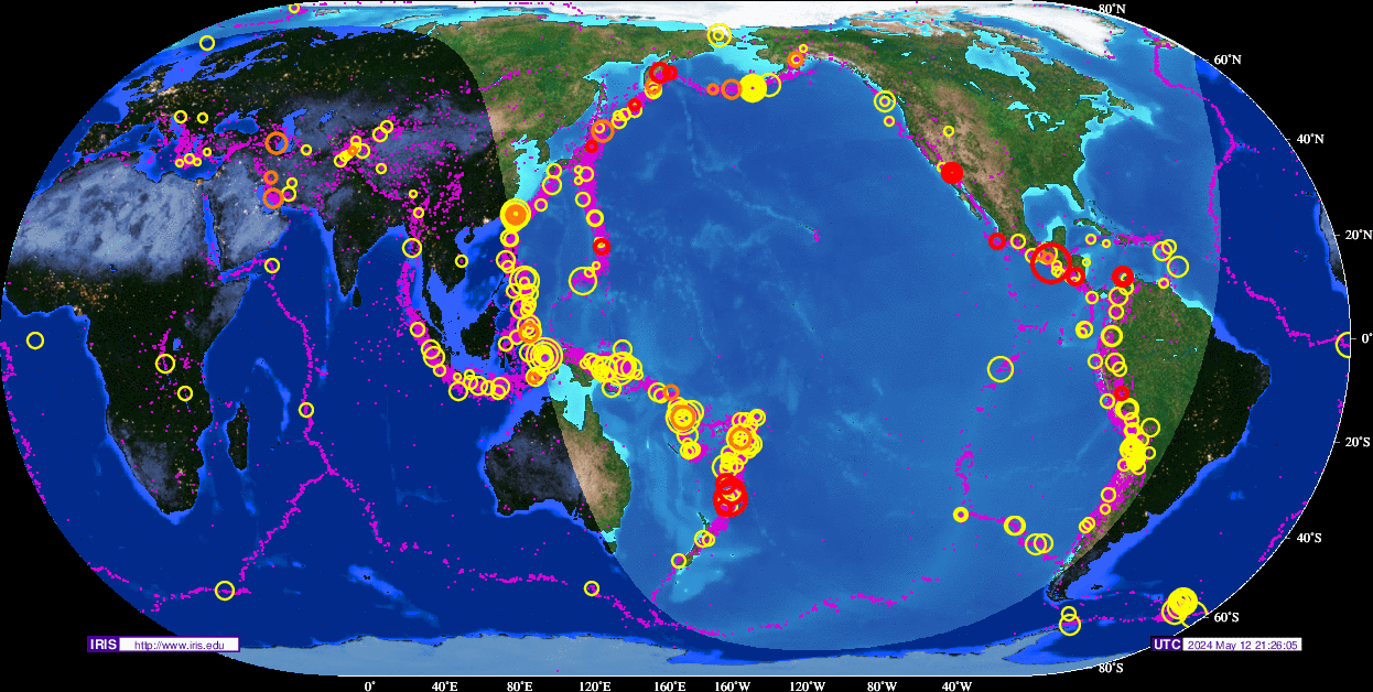
Overzichten Real-time aardbevingen
Europa
Rest van de wereld
Naslagwerken / Informatie / Nuttige Links / Sites
Aardbevingen
• Nederlandse Aardbevingsite
• US Geological Survey Website
• WikiPedia Aardbeving
• Natuurrampen pagina
• Europese (realtime) Aardbevingen
• Earthquake - Report
• Aardbevingsdossier Kennislink
• Aardbevingen, overzicht, hoe en waarom
Tsunami's
• WikiPedia Tsunami
• Tsunamidossier Kennislink
Deze op is te vinden in de FOK!Wiki:
[*] Fok!Wiki OP/Aardbevingen
| Wordfeud: marcel-o |plug.dj/uptempo |<-- draai zelf je platen
k had de laatste 
laatste posts
[ Bericht 34% gewijzigd door Frutsel op 15-09-2011 18:59:20 ]
laatste posts
quote:Op donderdag 15 september 2011 16:58 schreef Frutsel het volgende:
27 februari 2010 : 8.8 aardbeving Chili
189 dagen daarna
4 september 2010 : Zware aardbeving NieuwZeeland
188 dagen daarna
11 maart 2011: 9.0 aardbeving Japan
187-189 dagen daarna komen we op 15-16-17 september 2011....
als je deze vier bevingen bekijkt zou je denken dat nu de 4e hoek van het vierkant aan de beurt is... dus San Francisco - LA
quote:Op donderdag 15 september 2011 17:31 schreef marcel-o het volgende:
hier staat ook wat leuks:
http://www.earthwatcher.nl/universum/6174.html
[ Bericht 34% gewijzigd door Frutsel op 15-09-2011 18:59:20 ]
| Wordfeud: marcel-o |plug.dj/uptempo |<-- draai zelf je platen
Drukke dag vandaag... 6.0 bij Nieuw Zeeland, 6.2 bij Japan en 7.2 bij Fiji. Vooral die eerste en die laatste zitten dicht bij elkaar. De eerste op de coordinaten 35.430S 177.877W, de laatste een stukje noordelijker op 21.596S 179.270W
6.6 net bij Japan.Gaat steeds beter daar... NOT 
http://earthquake.usgs.gov/earthquakes/recenteqsww/Quakes/pt11259000.phpquote:NewEarthquake Earthquakes Tsunamis
Preliminary: 6.6 earthquake, Near East Coast of Honshu, Japan. On 2011/09/16 19:26:44 UTC (9m ago, depth 41km). http://j.mp/o4Fo9Z
10 minutes ago
I give myself very good advice
But I very seldom follow it
That explains the trouble that I'm always in
But I very seldom follow it
That explains the trouble that I'm always in
Zou der nog een klapper komen?
Doe mee met het voorspellen van het weer!
Weekvoorspelling | Week 12 (invullen tot 16-03 - 11:59)
Maandvoorspelling Maart (Inzendingen gesloten)
Jaarvoorspelling 2025 / 2026
Weekvoorspelling | Week 12 (invullen tot 16-03 - 11:59)
Maandvoorspelling Maart (Inzendingen gesloten)
Jaarvoorspelling 2025 / 2026
En nog een 6.2quote:
6.6 net bij Japan.Gaat steeds beter daar... NOT
[..]
http://earthquake.usgs.gov/earthquakes/recenteqsww/Quakes/pt11259000.php
http://earthquake.usgs.go(...)uakes/usc0005vyj.php
Da's de derde 6.0+ in die regio binnen twee dagen
6.2 36.289N 141.308E - 15 Sep 2011 08:00:07 UTC
6.6 40.288N 142.727E - 16 Sep 2011 19:26:42 UTC
6.2 40.221N 143.049E - 16 Sep 2011 21:08:05 UTC
En nu ook weer een 5,6.... gaat goed daar.quote:
[..]
En nog een 6.2
http://earthquake.usgs.go(...)uakes/usc0005vyj.php
Da's de derde 6.0+ in die regio binnen twee dagen
6.2 36.289N 141.308E - 15 Sep 2011 08:00:07 UTC
6.6 40.288N 142.727E - 16 Sep 2011 19:26:42 UTC
6.2 40.221N 143.049E - 16 Sep 2011 21:08:05 UTC
Dan hoop ik dat het geen voorschokken zijn voor nog een echte klapper. Naschokken van de 9.0 van 11 maart klinkt al een stuk beter...
Je vergeet er een paar...quote:
[..]
En nu ook weer een 5,6.... gaat goed daar.
6.6, 5.2, 5.5, 6.2, 5.6. In een tijdsbestek van twee uur en tien minuten. En alle vijf bij de oostkust van Honshu, Japan.
Niet alleen in Japan, ook India krijgt er van langs (14.40 onze tijd):
MAP 6.8 2011/09/18 12:40:48 27.730 88.082 20.7 SIKKIM, INDIA
MAP 6.8 2011/09/18 12:40:48 27.730 88.082 20.7 SIKKIM, INDIA
Út Ljouwert
Dodental stijgt daar 
quote:BREAKING NEWS:
Three people killed as British embassy compound wall collapses after earthquake in Nepali capital Kathmandu
quote:Deaths after quake in Nepal/India
A magnitude 6.8 earthquake shook India's Sikkim state on Sunday night, sending people running from their homes. The epicenter of the quake was about 40 miles from Gangtok, the state's capital, on the Nepalese border.
The Indian government has reported that eight people died in India and Nepal, at least three when a building in Kathmandu collapsed. The quake also created a number of mudslides on the outskirts of Gangtok, killing at least one man who was trapped inside his car.
Additionally, at least 100 people were injured, according to initial reports. The earthquake also temporarily disrupted telephone lines, and the rapid rate of cell phone use over-burdened mobile networks, according to The Hindustan Times.
The tremors were felt as far away as Delhi, about 900 miles to the west.
India sits on the Indian Plate, a tectonic plate that has been colliding with the Eurasia Plate for about 50 million years. The Indian Plate is slowly being wedged under Eurasia, pushing up the northern plate, causing it to lift. The tectonic movement created the Himalayan Mountain range, which straddles the collision point between India, Nepal, Tibet and China.
Because of the plates' movement, the Himalayas are growing taller every year.
Earthquakes in India aren't rare, but a 6.8 magnitude quake is significant. The most recent quake in the country occurred on Sept. 7, when a 4.2 magnitude quake hit Delhi, where just hours earlier a bomb blast killed 11 and injured dozens more outside the Delhi High Court.
Delhi is considered to be in Zone 4 of the Earthquake Hazard Map of India, and is therefore designated as being in the High Damage Risk Zone. There hasn't been a significant earthquake in the city's recent history, although it has experienced minor vibrations from quakes elsewhere in the country and in Pakistan.
Gangtok is also in Zone 4, and is nestled between two Zone 5 (highest risk) areas to the east and west.
On Sunday, there were also earthquakes reported in Virginia and New Zealand, although they were significantly less potent than the Sikkim quake.
A series of tremors in Virginia, ranging from magnitudes 1.9 to 2.1 on the Richter scale, are now considered to be aftershocks of the Aug. 23 earthquake that shook the East Coast of the United States, according to the U.S. Geological Survey. Meanwhile, a 4.1 magnitude quake hit North Queensland, New Zealand around 2:30 a.m. Sunday.
There have not been any reports of injuries or damages in either location.
Last Thursday, two significant earthquakes happened in Cuba and Japan, ranging from a 6.0 to a 6.2-magnitude respectively.
Are multiple earthquakes in the same day anything to worry about?
Considering that there are about 1.5 million earthquakes a year, not really. And that's just above magnitude 2.0. Below that, there are more millions.
Additionally, USGS claims that 134 earthquakes between the magnitudes 6 and 6.9 occur annually, the same magnitude as those that hit India, Cuba and Japan. Statistically, is it not unlikely that two would happened on the same day.
In the past week, there have been more than 250 earthquakes in Alaska alone, nearly 30 of which happened Sunday. In California and Nevada, there were nearly 400 quakes over the same period, the largest reaching around 4.0 magnitudes, according to USGS.
Yet, 2011 has seen its share of large-scale quakes. In March, a 9.0 earthquake hit Japan, causing enormous damage and a nuclear disaster at the Fukushima power plant. A month earthlier, a 6.3 magnitude earthquake in Christchurch, New Zealand killed nearly 200.
On Sept. 6, a 6.6 magnitude earthquake hit the Indonesian island of Sumatra, killing a 12-year-old boy who was lying in bed and a man who died of a heart attack as he fled his home.
Op de FP staat:
 Alleen een 4,6 en 4,8 in diezelfde regio.
Maar daar zie ik helemaal niks van op usgs staanquote:De beving werd gevolgd door minstens twee naschokken van 6,1 en 5,3

Al 36 doden na zware aardbeving in Himalaya
Bij de zware aardbeving gisteren in het noordoosten van India zijn ondertussen al 36 doden gevallen. De aardbeving was voelbaar tot in Nepal en Tibet en leidde tot grote stroomstoringen en paniek in het Himalayagebied. Ook in Tibet en de Britse ambassade in Nepal vielen doden te betreuren. De dodentol zal wellicht nog oplopen.
De beving met een kracht van 6,9 op de schaal van Richter was meer dan 1.000 kilometer verder voelbaar, tot in New Delhi in het westen en Bangladesh in het oosten. Minstens zestig personen raakten gewond door modderstromen, vallend puin en ingestorte gebouwen in Gangtok, de hoofdstad van de Indiase staat Sikkim in de Himalaya.
De elektriciteit in het gebied viel uit waardoor veel mensen in paniek de straat opvluchtten. Anderen sprongen uit de ramen van hun huizen. In het Nepalese parlement werd een debat over de begroting stopgezet terwijl parlementsleden het op een lopen zetten. (sps)
hln
NRC meldt die cijfers ook, maar ze kloppen volgens mij idd niet.quote:
Op de FP staat:
[..]
Maar daar zie ik helemaal niks van op usgs staan
26 people in India's Sikkim state were killed and more than 200 were injured
11 people were killed the neighboring Indian states of Bihar and West Bengal and more than 100 injuries
7 deaths confirmed in China and 22 injuries in southern Tibet
9 deaths confirmed in Nepal
Totaal meer dan 400 gewonden.
Verder zijn niet alle getroffen gebieden bereikt en zitten er nog mensen vast.
Mogelijk nu eindelijk de lang verwachtte uitbarsting bij de Cleveland vulkaan daar?quote:
Vanochtend al een 5.2 en een 5.4 bij Fox Islands, Aleutian Islands, Alaska, nu weer een 5.8.
Vulkaan Cleveland op weg naar flinke uitbarsting?

quote:Ground beneath Kanchenjunga slips south, alarm bells ring for Bengal
New Delhi, Sept. 18: A behemoth chunk of rock about 20km beneath the mountains around Kanchenjunga lurched southward today in the 6.9 magnitude earthquake that scientists say should stir the Bengal and Sikkim governments into a state of high alert.
The first and preliminary analysis of the mechanisms underlying the earthquake near the Sikkim-Nepal border suggests that the western edge of Sikkim had slipped southward relative to Nepal during the earthquake, geophysicists and seismologists said.
The first earthquake was followed by two smaller 4.8 and 4.6 magnitude earthquakes on the eastern side of the main event in a pattern that points to additional build-up of strain in subterranean rocks across Sikkim, three scientists tracking the events said.
“The movement of rock associated with the 6.9 event on the western side of Sikkim is likely to have caused a pile-up of strain towards its east leading to the two subsequent events," said Supriyo Mitra, a seismologist at the Indian Institute of Science Education and Research, Calcutta. “In a region where strain has accumulated for years, the 6.9 event was a trigger for the next two,” Mitra told The Telegraph.
Geophysicists say the two smaller earthquakes would not have released the enormous strain that has accumulated in the region. “The two (smaller) quakes were like peanuts,” said Vinod Gaur, a geophysicist at the Indian Institute of Astrophysics, Bangalore.
G.C Debnath, director of the Alipore meteorological centre, said: “The first tremor with an intensity of 6.9 on the Richter scale happened at 6.11pm, followed by a 5.7 intensity aftershock at 6.21pm. The third one happened at 6.43pm with 5.3 intensity, while the last one occurred at 7.24pm with intensity of 4.6 at Richter scale.”
“These are not aftershocks because they are not on the same fault as the first event,” said Mitra, the seismologist at the Indian Institute of Science Education and Research, who maintains four seismic monitoring stations in Sikkim.
Scientists say release of the accumulated strain in Sikkim could happen in months or years — and earthquakes cannot be predicted. “I think prudence dictates that Bengal and Sikkim should initiate action — at least across Sikkim and north Bengal — to scrutinise buildings such as schools and hospitals, where a large number of people assemble, for vulnerability and retrofitting using available engineering solutions,” said Gaur.
The Himalayan region marks the zone where India is slipping under Tibet at the rate of about 18mm per year. This tectonic plate movement leads to strain build-up, which is released when subterranean rocks along the slip zone reach their fracture points.
Scientists estimate that the amount of energy released during the 6.9 earthquake was equivalent to 340,000 tonnes of TNT, or about 22 times the energy released by the atomic bomb dropped on Hiroshima.
Geophysicists say earthquakes in the Himalayas are likely to cause significant shaking of structures built along the Gangetic plains across northern and eastern India. “The contrast between the soft sediments lying above the harder rock all along the Gangetic plains is likely to cause amplification of energy,” said Shyam Sunder Rai, a scientist at the National Geophysical Research Institute, Hyderabad.
“Whatever energy has been released by the earthquakes today does not rule out the possibility of an even bigger quake in other areas along the Himalayan region,” said Rai.
Gaur believes moderate earthquakes may mean that more are to come. “Moderate earthquakes in plate boundary environments such as the Himalayas therefore verily presage closeness of the region to a great rupture of magnitude 8 or so.”
The US Geological Survey said this region has experienced relatively moderate seismicity in the past with 18 earthquakes of magnitude 5 or larger over the past 35 years within 100km of the epicentre of today’s event. The largest of these was a magnitude 6.1 earthquake in November 1980 about 75km southeast.

en vulkanen opwekken 
Inorbit: zeg dat dan typluie triangeljosti
Beauregard: Een beetje FOK!ker laat het brood door z'n moeder smeren.
Ecosia
ek's 'n flash drive, jy's 'n floppy
Beauregard: Een beetje FOK!ker laat het brood door z'n moeder smeren.
Ecosia
ek's 'n flash drive, jy's 'n floppy
een voorbode voor guatamala? nog een paar schokken rond guatamala city...
Inorbit: zeg dat dan typluie triangeljosti
Beauregard: Een beetje FOK!ker laat het brood door z'n moeder smeren.
Ecosia
ek's 'n flash drive, jy's 'n floppy
Beauregard: Een beetje FOK!ker laat het brood door z'n moeder smeren.
Ecosia
ek's 'n flash drive, jy's 'n floppy
Aardbeving in India:
95 doden, 500 gewonden.
Aan ongeveer 100.000 gebouwen schade.
Aardbeving van gisteren in Guatemala:
3 doden en 50 gewonden.
Ook daar redelijk veel schade.
95 doden, 500 gewonden.
Aan ongeveer 100.000 gebouwen schade.
Aardbeving van gisteren in Guatemala:
3 doden en 50 gewonden.
Ook daar redelijk veel schade.

quote:Mega quakes occur more frequently when sun has fewer sunspots: researchers
The frequency of mega earthquakes increases during periods when the sun has fewer sunspots, a team of Japanese researchers has found.
The finding was made by a team led by Kiyofumi Yumoto, a researcher in space and earth electromagnetism at Kyushu University's Space Environment Research Center.
The March 11 Great East Japan Earthquake occurred when there were few sunspots. The latest research suggests that the sun's activity could influence movements beneath the earth's surface.
Sunspots gradually increase and decrease in number in a cycle of about 11 years, and cause changes in the earth's atmosphere. The research team investigated the possibility that they could also produce changes beneath the earth's surface, and compared data on the number of sunspots between 1963 and 2000 and the 327,625 earthquakes of magnitude 4 or more that occurred during this period.
The study found that 65 percent of the earthquakes with magnitudes between 4.0 and 4.9 occurred during the periods with the fewest sunspots (each lasting about two years). The figure was around the same for earthquakes with magnitudes between 5.0 and 7.9. However, the figure was higher for the 28 mega earthquakes with magnitudes in the 8.0-9.9 range, with 79 percent of them occurring during periods with the fewest sunspots.
When there are fewer sunspots, a phenomenon occurs in which solar winds, or streams of charged particles from the sun, get stronger an average of three to four times a month. Seventy percent of the earthquakes of magnitude 6.0 or stronger occurred at such times.
Solar winds that become stormy are known to be able to induce strong currents in power transmission lines, which can lead to major blackouts.
"The relationship between the sun and the activity of earthquakes is not clear, but we hope that this is a step in uncovering the mystery of quakes," Yumoto said.
The results of the group's research will be announced at a meeting of the Society of Geomagnitism and Earth, Planetary and Space Sciences, which opens in Kobe on Nov. 3.
Schokkende beelden paniek bij toeristen tijdens aardbeving in Washington Monument
Gezinnen met kinderen stormen van trap; gebouw trilt 2’; barsten in muur, puin valt naar beneden
Bekijk de beelden hieronder, vanaf 1'45" begint paniek
Vorig maand werd de Amerikaanse oostkust getroffen door een zware aardbeving. Ook Washington kreeg de volle laag en er brak paniek uit. Zeker bij de toeristen die zich op het moment van de forse aardschok in het Washington Monument bevonden. Zo'n 150 meter boven de begane grond sloeg de angst hen om het hart toen het erg smalle gebouw begon te trillen. Er vielen ook heel wat brokstukken uit de top van de toren en de wand van het Monument vertoont heel wat grote barsten. Meer dan een maand na de aardbeving is de populaire attractie nog altijd gesloten wegens herstellingswerken. De beelden van een bewakingscamera, te bekijken onder dit artikel, in het gebouw zijn (letterlijk en figuurlijk) schokkend.
Jonge gezinnen met kinderen rennen in paniek van de trappen met hun kinderen op hun arm. De smalle trap moet het benauwde gevoel nog vergroot hebben. Het trillen van het hoge gebouw duurt zo'n twee minuten. In de video van de bewakingscamera is te zien hoe de gids de toeristen naar beneden begeleidt: via de trap naar de nooduitgang. Vervolgens keerde ze terug naar boven om te controleren of alle bezoekers uit het gebouw waren.
170 meter hoog
Het Washington Monument is net geen 170 meter hoog en het was helemaal bovenaan dat de grootste schade werd opgemeten. Zeker omdat het gebouw enkele dagen later nog eens geteisterd werd door de extreme windkracht en overvloedige regen van orkaan Irene. Daarbij ontstonden nog meer barsten in de stenen muur en zelfs wat wateroverlast.
800.000 bezoekers per jaar
Het Washington Monument is één van de belangrijkste toeristische attracties in de Amerikaanse hoofdstad. Het werd opgericht voor George Washington, de eerste Amerikaanse president. Het is de hoogste obelisk ooit gebouwd en is opgetrokken uit marmer, graniet en zandsteen. Het monument maakt deel uit van de National Mall, die zich uitstrekt van het Capitool tot aan het Washington Monument. Er werd liefst 36 jaar aan gewerkt (1848-1884). Het monument lokt een massa toeristen: jaarlijks 800.000. Een lift neemt de bezoekers mee naar de top van de obelisk waar in alle vier de wanden kleine ramen van een vierkante meter zijn aangebracht. (kh)
hln
[ Bericht 1% gewijzigd door #ANONIEM op 27-09-2011 14:09:28 ]
Gezinnen met kinderen stormen van trap; gebouw trilt 2’; barsten in muur, puin valt naar beneden
Bekijk de beelden hieronder, vanaf 1'45" begint paniek

Vorig maand werd de Amerikaanse oostkust getroffen door een zware aardbeving. Ook Washington kreeg de volle laag en er brak paniek uit. Zeker bij de toeristen die zich op het moment van de forse aardschok in het Washington Monument bevonden. Zo'n 150 meter boven de begane grond sloeg de angst hen om het hart toen het erg smalle gebouw begon te trillen. Er vielen ook heel wat brokstukken uit de top van de toren en de wand van het Monument vertoont heel wat grote barsten. Meer dan een maand na de aardbeving is de populaire attractie nog altijd gesloten wegens herstellingswerken. De beelden van een bewakingscamera, te bekijken onder dit artikel, in het gebouw zijn (letterlijk en figuurlijk) schokkend.
Jonge gezinnen met kinderen rennen in paniek van de trappen met hun kinderen op hun arm. De smalle trap moet het benauwde gevoel nog vergroot hebben. Het trillen van het hoge gebouw duurt zo'n twee minuten. In de video van de bewakingscamera is te zien hoe de gids de toeristen naar beneden begeleidt: via de trap naar de nooduitgang. Vervolgens keerde ze terug naar boven om te controleren of alle bezoekers uit het gebouw waren.
170 meter hoog
Het Washington Monument is net geen 170 meter hoog en het was helemaal bovenaan dat de grootste schade werd opgemeten. Zeker omdat het gebouw enkele dagen later nog eens geteisterd werd door de extreme windkracht en overvloedige regen van orkaan Irene. Daarbij ontstonden nog meer barsten in de stenen muur en zelfs wat wateroverlast.
800.000 bezoekers per jaar
Het Washington Monument is één van de belangrijkste toeristische attracties in de Amerikaanse hoofdstad. Het werd opgericht voor George Washington, de eerste Amerikaanse president. Het is de hoogste obelisk ooit gebouwd en is opgetrokken uit marmer, graniet en zandsteen. Het monument maakt deel uit van de National Mall, die zich uitstrekt van het Capitool tot aan het Washington Monument. Er werd liefst 36 jaar aan gewerkt (1848-1884). Het monument lokt een massa toeristen: jaarlijks 800.000. Een lift neemt de bezoekers mee naar de top van de obelisk waar in alle vier de wanden kleine ramen van een vierkante meter zijn aangebracht. (kh)
hln
[ Bericht 1% gewijzigd door #ANONIEM op 27-09-2011 14:09:28 ]
Ja, dat krijg je dan, als je als een Amerikaans formaat gezin de trap af dendertquote:Op dinsdag 27 september 2011 14:05 schreef aloa het volgende:
Schokkende beelden paniek bij toeristen tijdens aardbeving in Washington Monument
Gezinnen met kinderen stormen van trap; gebouw trilt 2’; barsten in muur, puin valt naar beneden
<knip>
Als het niet met een hamer te repareren is, is het een elektrisch probleem.
Valt mee...zag eerst 6.6 voorbij komen
[ Bericht 31% gewijzigd door Frutsel op 29-09-2011 12:18:22 ]
updatequote:FLASH: Magnitude 5.6 earthquake jolts Fukushima prefrecture in northeastern Japan - TV
quote:FLASH: No report of abnormalities at Fukushima nuclear plant after northeast Japan earthquake - NHK
[ Bericht 31% gewijzigd door Frutsel op 29-09-2011 12:18:22 ]
Ruim een week terug was het 7.0..... toen 7.7... nu 8.0twitter:Quakeprediction twitterde op donderdag 29-09-2011 om 14:30:54 Earthquake warning for the Los Angeles basin & Salton Sea. 8.0 earthquake likely to hit near the Salton Sea; http://t.co/wmi2x9oP reageer retweet
 Earthquake warning for the Los Angeles basin & Salton Sea. 8.0 earthquake likely to hit near the Salton Sea;
Hehe, hilarisch leuk die voorspellingen af en toe hequote:Ruim een week terug was het 7.0..... toen 7.7... nu 8.0twitter:Quakeprediction twitterde op donderdag 29-09-2011 om 14:30:54 Earthquake warning for the Los Angeles basin & Salton Sea. 8.0 earthquake likely to hit near the Salton Sea; http://t.co/wmi2x9oP reageer retweet
Ooit zal die vent gelijk krijgen en dan hoop ik toch echt dat ze hem niet als held of geologisch wonder gaan bestempelen omdat hij er al een paar dagen voor waarschuwde.
Ik denk van wel, genoeg mensen die niet verder kijken dan hun neus lang isquote:
Ooit zal die vent gelijk krijgen en dan hoop ik toch echt dat ze hem niet als held of geologisch wonder gaan bestempelen omdat hij er al een paar dagen voor waarschuwde.
Een hoop mensen die denken dat die schaal net zoiets als de temperatuur is, hebben geen idee wat een logaritmische schaal inhoudtquote:Ruim een week terug was het 7.0..... toen 7.7... nu 8.0twitter:Quakeprediction twitterde op donderdag 29-09-2011 om 14:30:54 Earthquake warning for the Los Angeles basin & Salton Sea. 8.0 earthquake likely to hit near the Salton Sea; http://t.co/wmi2x9oP reageer retweet
[b]Op maandag 6 september 2010 00:28 schreef tong80 het volgende:[/b]
GVD Wat moet jij een trotse vader zijn :)
:P
GVD Wat moet jij een trotse vader zijn :)
:P
Ik ben momenteel een documentaire aan het maken over aardbevingen in Nederland. We hebben o.a. al gefilmd bij het KNMI (met het hoofd van de afdeling Seismologie) en bij de Peelrandbreuk. We gaan volgende week naar het VU Amsterdam en binnenkort naar Roermond om interview met het gemeentebestuur te maken.
Het is een zeer interessant onderwerp waar meer bij komt kijken dan alleen de bevingen.
We zoeken nog mensen die de aardbeving van 1992 in Roermond hebben meegemaakt en daar voor de camera over willen vertellen. Misschien zijn er zelfs mensen die nog videobeelden of foto's van de schade destijds hebben?
De documentaire wordt geen opgeklopt sensatieverhaal maar gewoon eerlijk en oprechte voorlichting!

USGS zet in op 5.7-6.1quote:GFZ Potsdam - Earthquake Bulletin
F-E Region: Salta Province, Argentina
Time: 2011-10-06 11:12:29.8 UTC
Magnitude: 6.3

4.7 5.5 naschok in Canterbury,NZ
volgens de NZ Geonet site
[ Bericht 51% gewijzigd door rechtsedirecte op 09-10-2011 10:04:27 ]
volgens de NZ Geonet site
[ Bericht 51% gewijzigd door rechtsedirecte op 09-10-2011 10:04:27 ]
'Lopen is geen sport maar een manier van reizen'
'Als ik loop voel ik me beroerd, maar als ik niet loop nog beroerder'
'Once you discover the rewards of pain, you want more pain'
'Als ik loop voel ik me beroerd, maar als ik niet loop nog beroerder'
'Once you discover the rewards of pain, you want more pain'
Nu zijn Griekenland, Italie en Turkije redelijk vaak onrustig met bevinkjes, maar de laatste dagen vind ik het rond Griekenland wel erg onrustigquote:2011-10-10 06:03:29.52hr 13min ago 37.15 N 22.02 E 10 2.3 SOUTHERN GREECE
2011-10-10 05:06:28.73hr 10min ago 37.13 N 22.01 E 10 2.0 SOUTHERN GREECE
2011-10-10 04:49:46.03hr 26min ago 37.31 N 22.10 E 2 4.1 SOUTHERN GREECE
2011-10-10 03:29:56.64hr 46min ago 39.70 N 23.85 E 5 2.3 AEGEAN SEA
2011-10-10 03:22:26.94hr 54min ago 39.53 N 23.69 E 10 2.5 AEGEAN SEA
2011-10-10 02:57:44.05hr 18min ago 38.31 N 20.45 E 2 2.9 GREECE
2011-10-10 01:20:57.06hr 56min ago 37.22 N 22.04 E 1 4.2 SOUTHERN GREECE
2011-10-10 01:19:00.56hr 58min ago 37.17 N 21.99 E 10 2.2 SOUTHERN GREECE
Gebruiken ze nu weer 2 schalen? 6.8 of 6.0 is nogal een verschilquote:Tientallen gewonden op Bali na aardbeving
Een sterke aardbeving ten zuiden van het eiland Bali op donderdag in de morgen heeft voor schade en gewonden gezorgd op het toeristische eiland Bali in Indonesië. Het is niet bekend of er ook doden zijn gevallen.
De aardbeving met een magnitude van 6,8 vond plaats om 11:16 lokale tijd en lag op zo'n 143 kilometer ten zuidwesten van Nusa Dua. De beving vond plaats op een diepte van 10 kilometer, waarmee het een oppervlakkige beving was, aldus het Klimatologisch, Meteorologisch en Geofysisch Agentschap BMKG.
De Amerikaanse tegenhanger van de BMKG, het USGS, heeft de beving vastgesteld op een magnitude 6.0, en stelt dat bijna 4,6 miljoen mensen de beving gevoeld hebben. Ooggetuigen meldden dat in diverse delen van het eiland mensen in paniek hun hotels en huizen ontvluchtten.
Er is bovendien schade ontstaan aan diverse gebouwen. Enkele hiervan zouden ook ingestort zijn. Volgens de politie zouden er 46 mensen gewond geraakt zijn. Er is voor deze beving geen tsunami-alarm uitgegeven, omdat de beving hiervoor niet sterk genoeg zou zijn.

Opvallende (zware) beving voor de kust van Oregon VS.
Was daar niet laatst ook een onderzeese vulkaan uitgebarsten?
quote:Strong earthquake offshore Oregon
A strong earthquake struck off the coast of Oregon on early Wednesday evening, seismologists said, but there were no reports of damage or casualties and no tsunami warning was issued.
The 5.3-magnitude earthquake at 8.13 p.m. local time (0413 GMT Thursday) was centered about 144 miles (233 kilometers) west of Coos Bay, a city located in Coos County on the Pacific coast. It struck about 6.2 miles (10 kilometers) deep, making it a shallow earthquake, according to the United States Geological Survey (USGS).
The USGS said it did not expect to see damage or casualties due to the earthquake’s distance from the coast, and there were no immediate reports of tremors being felt anywhere along the coast.
Wednesday’s earthquake was one of the strongest earthquakes to hit off the coast of Oregon in recent years, but no tsunami warning was issued by the West Coast and Alaska Tsunami Warning Center (WCATWC).
Ah, aardbevingen voorspellen!quote:Toeristen Bali wachten op nieuwe aardbeving
NUSA DUA - Nederlandse toeristen op Bali kunnen binnen enkele uren nog een zware aardbeving verwachten. Indonesische media waarschuwen de inwoners van Bali zich voor te bereiden op een nieuwe beving.
De eerste beving heeft nog geen levens geëist maar vele gebouwen zijn ernstig beschadigd en niet meer toegangbaar. Ook zijn er in het zuiden van Bali, bij Nusa Dua, grote scheuren waar te nemen in de weg. "Scheuren zo groot dat je je voet erin kwijt kan," vertelt een verontruste Nederlander op Bali.
"Vooral de toeristen die niet bekend zijn met aardbevingen waren erg in paniek. Zelfs de inwoners van Bali, die veel te maken hebben met aardbevingen, schrokken van de grootte van deze beving." De eerste beving had een kracht van 6,2 op de schaal van Richter.
Naschokken misschien... of was dit een voorschok

Volgens de OP... gemiddeld 20 aardbevingen van 7.0-7.9 per jaar
Waar zitten we nu op?
Januari 4
Februari 0
Maart 1
April 2
Mei 0
Juni 1
Juli 2
Augustus 2
September 2
totaal nu 14... gemiddeld genomen nog 6 te gaan in de laatste 3 maanden... wat op zich prima zou kunnen.
Tussen de laatste in Januari en die in Maart zat ongeveer 50 dagen
Tussen die eind april en eind juni zat bijna 75 dagen
Gemiddeld komen er 2 bevingen 8.0 of hoger voor per jaar. Tot nu toe hebben we er één gehad.
Jaar lijkt 'prima op schema' te liggen...de komende 7+ zal wel niet lang meer op zich laten wachten
quote:Rare moderate earthquakes rattles Southern Texas
A shallow, moderate earthquake struck southern Texas (TX) on Thursday morning, according to the United States Geological Survey (USGS). It was one of the strongest earthquakes to hit the region in at least two decades.
The 4.6 magnitude quake hit at 07:25 AM local time (13:25 PM GMT) and was recorded at a depth of 5 km (3.1 miles). The EMSC estimated that the quake measured 5.0mb on the Richter Scale.
The epicentre of the quake was located 22 km (14 miles) NW (321°) from Pawnee, TX; 23 km (14 miles) SSW (213°) from Falls City, TX; 26 km (16 miles) WSW (249°) from Karnes City, TX; 60 km (37 miles) NW of Beeville, TX; 76 km (47 miles) SSE (154°) from San Antonio, TX; 166 km (103 miles) SSW of AUSTIN, TX; 92 km (57 miles) E of Pearsall, TX; and 463 km (288 miles) SSW (197°) from Dallas, TX.
The most recent earthquake to strike the region hit on 25 April, 2010. The 4.0 magnitude earthquake was recorded 56 km west of Corpus Christi.
Texas has no active or dormant volcanoes and few earthquakes, being situated far from an active plate tectonic boundary. The Big Bend area, located about 550 kilometres west of San Antonio, is the most seismically active; however, the area is sparsely populated and suffers minimal damages and injuries, and no known fatalities have been attributed to a Texas earthquake.