WKN Weer, Klimaat en Natuurrampen
Lees alles over het onstuimige weer op onze planeet, volg orkanen en tornado's, zie hoe vulkanen uitbarsten en hoe Moeder Aarde beeft bij een aardbeving. Alles over de verwoestende kracht van onze planeet en tal van andere natuurverschijnselen.


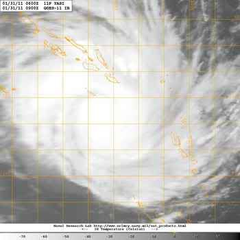
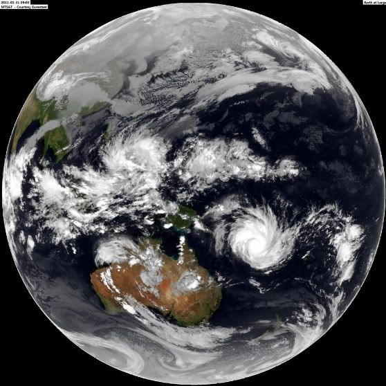
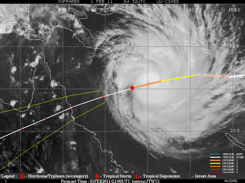
Yasi op weg naar Queensland Australie.
zie ook:
Overstromingen Australie: Ergste in honderd jaar
Hurricane Season 2011
[ Bericht 2% gewijzigd door Frutsel op 31-01-2011 12:26:55 ]


quote:Alle ogen gericht op cycloon Yasi
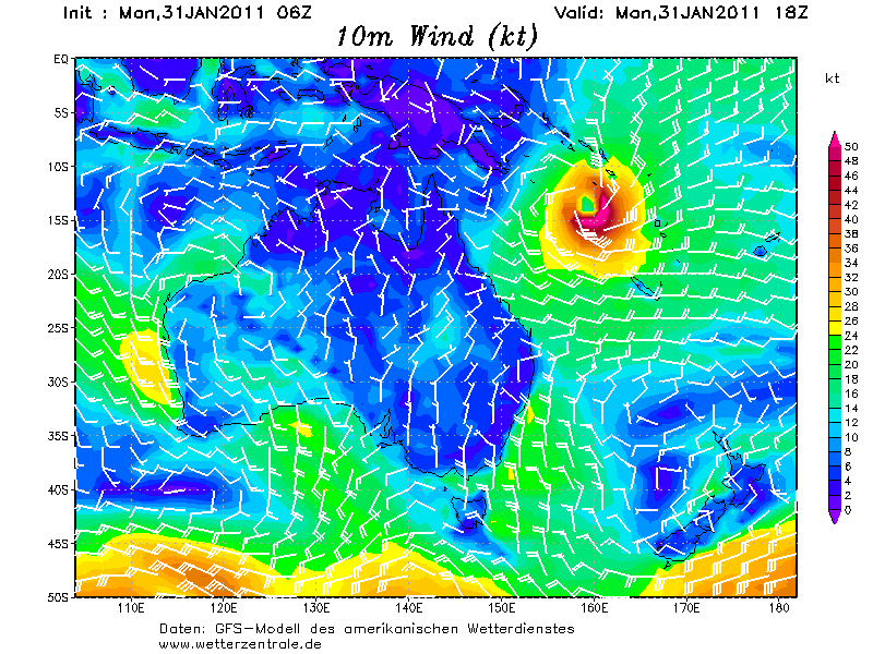
De bewoners van Rockhampton, die afgelopen maand getroffen werden door overstromingen kunnen hun borst nat maken. De bewoners zijn gewaarschuwd om zich voor te bereiden. Yasi zal naar alle waarschijnlijkheid een potentiële gevaarlijke cycloon gaan worden, die woensdagavond of donderdag met een categorie 3 aan land zal komen. Momenteel berekenen de weermodellen van de US Navy dat er windstoten voor kunnen gaan komen die op kunnen lopen tot 200 kilometer per uur.
Verwacht wordt dat cycloon Yasi aan land komt tussen Cooktown en Hervey Bay. De cycloon is minstens vier keer zo groot als cycloon Anthony. Naarmate de dag vordert zal er meer informatie volgen door het meteorologisch bureau (BOM), die hebben de verantwoordelijkheid op dat gebied. De computer modellen suggereren dat het heel snel naar het oosten zal trekken in de komende paar dagen.
Er moet niet alleen gekeken worden naar de wind die de cycloon met zich meebrengt, ook enorme hoeveelheden neerslag worden er verwacht in het centraal Queensland later deze week. De verwachtte neerslag loopt momenteel uiteen van meer dan 200mm voor St Lawrence, 150mm voor Rockhampton en bijna 300mm bij Mackay. Deze enorme hoeveelheden neerslag kunnen makkelijk leiden tot overstromingen.
©onweer-online
zie ook:
Overstromingen Australie: Ergste in honderd jaar
Hurricane Season 2011
[ Bericht 2% gewijzigd door Frutsel op 31-01-2011 12:26:55 ]
Wat een drama voor die mensen daar. Hebben ze net het ergste achter de rug, en begint het allemaal weer opnieuw. 
Ze hebben vannacht 100mm water gehad in Queensland, door Cycloon Anthonyquote:Op maandag 31 januari 2011 11:14 schreef Infection het volgende:
Wat een drama voor die mensen daar. Hebben ze net het ergste achter de rug, en begint het allemaal weer opnieuw.
Komt dit er nog achteraan

Yasi kan de grootste cycloon worden die Australie ooit heeft gezien. De verwachting is dat de cycloon met windsnelheden tot 260 km landfall gaat maken en een enorme hoeveelheid aan neerslag gaat achterlaten.
[ Bericht 0% gewijzigd door #ANONIEM op 31-01-2011 12:50:05 ]

quote:Premier Anna Bligh says the cyclone bearing down on the Queensland coast has the potential to be the biggest the state has ever seen.
Ms Bligh is calling on Queenslanders to prepare for gale-force winds, torrential rain and massive storm surges when Cyclone Yasi crosses the coast on Wednesday night.
Authorities fear the massive cyclone, which could pack winds up to 260 kilometres per hour, may be as intense as Cyclone Larry, which devastated parts of far north Queensland in 2006.
"[Yasi] may well be one of the largest and most significant cyclones that we have ever had to deal with," Ms Bligh said.
"This is an event we have to take seriously. I know cyclones can at the last minute turn off the coast, and I certainly hope this one does.
"But the bureau advises me in the most serious terms, that all of the modelling right now says this is going to cross our coast."
Ms Bligh says Yasi is expected to turn into a category-four system by Wednesday.
She says while areas between Cooktown and Maryborough are likely to be affected, the Innisfail to Mackay region will bear the brunt of the cyclone.
"We expect to see gales in that Innisfail to Mackay region of more than 100kph by mid-morning on Wednesday," she said.
"We are encouraging people in that region to start stocking up and begin preparing yourselves, your homes and your families for a very significant event."
She says the threat of the cyclone is compounded by severe rainfall in areas already saturated by a wet summer.
"In addition to the effects of a cyclone, we are preparing in that Innisfail to Mackay region for potential flooding of low-lying waterfront areas," she said.
"The best advice we can give to people in those areas is to start considering possible relocation on Tuesday."
Ms Bligh says the rain could affect areas in central and western Queensland still reeling from December's floods.
"We expect to see this event to become a significant rainfall event in areas to the south and surrounding where it crosses the coast.
"That means we can expect very significant rainfall, in some cases up to a metre, into catchments that are already saturated."
"We are currently doing modelling into what that might mean, particularly into areas such as the central and western areas of Queensland... which we have already seen significant flooding in."
All ports from Cairns to Mackay will be closed by tomorrow afternoon and the Premier is urging those with waterfront properties in the affected areas to evacuate.
Evacuations have already started at some nursing homes in the main danger zone and at Hamilton Island in the Whitsundays.
Weather forecasters says it is very unusual to have two cyclones tracking the same path only days apart.
Yasi is tracking a very similar path to Cyclone Anthony that crossed the coast near Bowen on Sunday night.
Forecaster Greg Connors says he cannot remember anything quite like it.
"Usually at this time of year the Coral Sea is constantly changing, but for the next few days it's showing a general westerly flow and that flow is capturing not only Anthony but also the upstream Tropical Cyclone Yasi," he said.
[ Bericht 0% gewijzigd door #ANONIEM op 31-01-2011 12:50:05 ]
Ze vergelijken hem al met de cycloon Larry die in 2006 voor veel ellende heeft gezorgd
Weer of geen weer, altijd actueel www.onweer-online.nl

Wat een joekel joh 
Ik dacht dat ze hem zouden vergelijk die met eind 19e eeuw, Larry of Vance, maar Larry dus.
Arm Queensland 
Ik dacht dat ze hem zouden vergelijk die met eind 19e eeuw, Larry of Vance, maar Larry dus.
Arm Queensland

quote:Yasi could be Qld's worst storm
QUEENSLAND'S island resorts are being evacuated and ports closed ahead of Cyclone Yasi, which threatens to develop into one of the worst storms the state has seen.
Premier Anna Bligh on Monday said Hamilton Island, in the Whitsundays, was starting to evacuate its guests, and other resort islands were preparing to evacuate on Tuesday.
Yasi will be a severe category three or four cyclone when it crosses the coast on Thursday morning, likely between Innisfail and Proserpine.
Ms Bligh told reporters that authorities were preparing for the cyclone to trigger a storm surge that could flood low-lying areas between Innisfail and Mackay.
Residents in low-lying waterfront areas there should consider staying with friends from Tuesday, she said.
"This is a very serious threat," Ms Bligh told reporters in Brisbane.
"We have to take this very seriously and we're preparing for it.
"In addition to a very significant cyclone, possibly one of the largest we have ever seen in Queensland, we expect to see this event become a significant rainfall event in areas to the south and surrounding where it crosses the coast."
Falls of up to one metre could hit areas that have already been flooded this month, and the government was working on models to show what that would mean for central Queensland.
Ports from Cairns to Mackay will be closed from late on Tuesday.
Yasi was not expected to dissipate quickly, or turn off the coast, Ms Bligh said.
"All of the modeling right now says this is going to cross our coast ... and it may well be one of the largest and most significant cyclones that we've ever had to deal with," she said.
"We will need to take every precaution and make every preparation and that is what we are doing."
Yasi could rival Larry: BoM
A SEVERE cyclone expected to hit Queensland on Thursday is likely to rival, and on some measures, dwarf Cyclone Larry, which devastated parts of north Queensland.
The Bureau of Meteorology says Cyclone Yasi will be a severe category three or four cyclone when it crosses the Queensland coast, likely early on Thursday morning.
Bureau senior forecaster Ann Farrell said the latest modelling suggested Yasi would make landfall somewhere between Innisfail, in the north, and Proserpine, in the south.
If it hits as a category three, wind gusts up to 200km/h can be expected, and 250km/h if it builds to a four, as Cyclone Larry was when it devastated Innisfail and surrounding communities in March 2006.
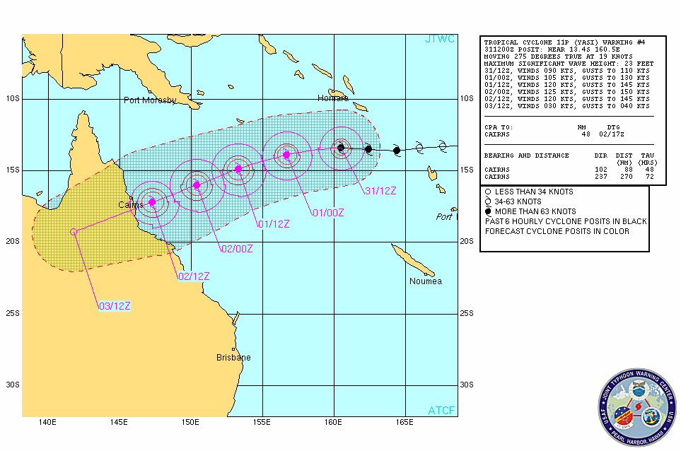
It's currently off Vanuatu, about 1975km east, northeast of Townsville, and moving westward at about 30km/h.
"At this stage we're expecting it to continue moving towards the Queensland coast and intensify ... and it's likely to reach the coast early on Thursday morning," Ms Farrell told AAP on Monday.
"By that stage we will be looking at a severe tropical cyclone so certainly at least a (category) three, and a category four we wouldn't be ruling that out by any means."
She said the last cyclone of that magnitude to hit Queensland was category four Cyclone Larry.
Larry left a trail of destruction including damage to 10,000 homes and a repair bill of more than a billion dollars.
Ms Farrell said there were many measures on which to judge cyclones, including wind strength and the physical size of the storm.
In terms of wind strength, Yasi had the potential to rival Larry, but it was of a far greater physical size.
"One measure is how far do the gales extend from the central eye. In this case, Yasi is certainly a bigger storm," she said.
She said forecasts for Yasi would be refined as it approached, but all the modelling showed it was on course to hit the coast.
She said Yasi was a fairly fast moving system, meaning it was unlikely, on current information, to stay in the same location and dump vast amounts of rain on an already flood-devastated state.
She said the other factor to consider was the storm surge that would likely accompany the cyclone.
"The more intense the system, the greater the concern about storm surges," Ms Farrell said.
"Certainly that is a distinct threat with this system.
"How far up above the normal high water mark it reaches will depend on the timing and what the tide is. Whether it is high tide or low tide will make a difference."
Meanwhile, Brisbane District Disaster Co-ordinator Peter Martin warned residents in the southeast not to be complacent.
"We do live in the tropics and the sub-tropics and equally cyclones can impact the southeast corner of Queensland," he said on Monday.
"Their history shows that they can impact upon us directly or they can impact upon us indirectly as a result of a significant pattern including increased rain that can occur in the context of a cyclonic event."
Mr Martin said people should stock up on torches, battery-operated radios, water, food, medicine, fuel and first-aid and monitor weather alerts.
"This is not a time to be alarmed but certainly a time to (take) precaution," he said.
Disaster management groups across north Queensland are meeting to plan for Yasi's arrival, the Department of Community Safety told AAP.
Premier Anna Bligh is also in talks with Emergency Management Queensland chiefs.
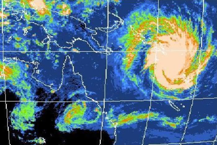
Queensland: na de overstromingen komen de cyclonen
2011 is slecht begonnen in het Australische Queensland. Eerst stond een groot deel van de staat onder water, nu raast de cycloon Anthony over de regio. En Anthony is nog maar de voorbode van de veel sterkere cycloon Yasi, die het gebied binnen enkele dagen zal treffen.
De tropische cycloon Anthony liet al een spoor van vernieling achter: daken werden losgerukt en hele straten kwamen blank te staan. Maar de echte vrees is er voor cycloon Yasi, die woensdag de kustlijn zal bereiken. Anna Bligh, premier van Queensland, vergeleek Anthony en Yasi al met 'David en Goliath'. 'Dit is een ernstige bedreiging voor onze regio', zei ze. 'Yasi wordt waarschijnlijk de krachtigste cycloon waar we ooit mee te maken kregen.'
Er wordt voorspeld dat Yasi tot 'categorie 4' zal behoren eens hij aan land komt. Dat betekent windstoten tot meer dan 250 kilometer per uur en maakt hem even sterk als orkaan Katrina, die in 2005 een groot deel van het Amerikaanse New Orleans met de grond gelijk maakte.
De ellende houdt dus voorlopig nog niet op voor Queensland, dat eerder deze maand werd getroffen door niets ontziende overstromingen. Zeker 35 mensen kwamen om het leven, 30.000 huizen kwamen blank te staan, wegen en spoorlijnen werden vernietigd en het economische leven stond stil.
Het zou nu al tot maart geduurd hebben voor de koolmijnen en de suikerindustrie (de voornaamste industrieën uit de regio, red.) weer op volle toeren konden draaien. Het is nog onduidelijk hoeveel roet de twee cyclonen daarbij in het eten zullen gooien.
bron
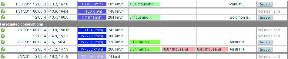
Het is nu een categorie 1 met windsnelheden tot net boven de 120 km/uur en windstoten tot 144 km/uur. Met een snelheid van 32 km/uur trekt de cycloon, in kracht toenemend, westwaarts richting Australie.

Het is nu een categorie 2. (windsnelheid 168 km/uur met windstoten tot net boven de 200 km/uur).
Neemt wel heel snel in kracht toe... morgen is het al een categorie 4.
[ Bericht 28% gewijzigd door #ANONIEM op 31-01-2011 15:05:52 ]
Neemt wel heel snel in kracht toe... morgen is het al een categorie 4.
[ Bericht 28% gewijzigd door #ANONIEM op 31-01-2011 15:05:52 ]
quote:Very dangerous Tropical Cyclone Yasi headed for Australia's flooded Queensland
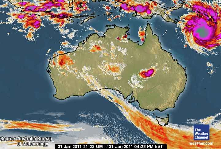
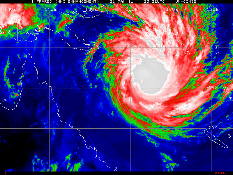
With February nearly upon us, the traditional peak of the Southern Hemisphere tropical cyclone season is here, and the waters surrounding Australia have been exceptionally active over the past week. We had the year's first two Category 4 tropical cyclones last week, Tropical Cyclone Wilma and Tropical Cyclone Bianca. Wilma passed over American Samoa as a strong tropical storm, and hit Tonga as a Category 3 storm, causing substantial damage to the islands, but no deaths or injuries. Wilma brushed New Zealand, bringing flooding and landslides to the North Island, and was the strongest tropical cyclone to affect that country in fourteen years, according to weatherwatch.co.nz. Tropical Cyclone Bianca skirted the west coast of Australia and dissipated before making landfall. Tropical Cyclone Anthony hit flood-ravaged Queensland, Australia, over the weekend, as a weak tropical storm with 40 - 50 mph winds. Fortunately, Anthony dropped only modest amounts of rain, and no new flooding disaster occurred in Queensland, which is struggling to recover from record floods. As reported in the latest Australian Bureau of Meteorology climate statement and flood summary, the past four months (September - December) have been the rainiest such period in Queensland's history, and the resulting flooding disaster has been Australia's most expensive natural disaster in history.
Queensland is in serious danger of renewed extreme flooding this week from Tropical Cyclone Yasi. Yasi has intensified to a Category 2 storm with 105 mph winds, and is undergoing a period of rapid intensification that is expected to take it to Category 4 strength. Yasi is expected to hit Queensland on Wednesday, probably as a major Category 3 or stronger storm. In addition the storm's damaging winds and storm surge, Yasi will bring torrential rains. The GFS model is predicting that Yasi will dump 5 - 10 inches of rain over a large swath of Queensland, which would likely cause destructive flooding.
One positive note: the European Center model was remarkably accurate predicting the formation of Yasi over a week in advance, so Queensland has had plenty of time to prepare for the arrival of the storm.
Wunderground

quote:Evacuations begin ahead of cyclone Yasi
Evacuations will begin today in Queensland as a severe cyclone is expected to strike the flood ravaged state.
Authorities are preparing as far north as Cooktown and as far south as Maryborough, with nursing homes in the danger zone and Whitsunday's Hamilton Island already evacuating.
Yasi is expected to be a severe category four cyclone when it crosses the coast on Wednesday evening, likely between Innisfail and Proserpine.
Advertisement: Story continues below
Daydream Island will evacuate guests and staff on Tuesday and Tourism Whitsundays is arranging extra flights out of nearby Proserpine to cope with numbers.
Ports from Cairns to Mackay will close by late on Tuesday and other resort islands are working on their evacuation plans.
Whether schools would need to close was still being considered.
Authorities warn a storm surge could occur between Innisfail and Mackay and residents in low-lying, waterfront areas should consider staying with friends from Tuesday.
The Bureau of Meteorology said the last cyclone of a similar magnitude to hit Queensland was category four Cyclone Larry in March 2006.
Larry left a trail of destruction including damage to 10,000 homes and a repair bill of more than a billion dollars.
Volgens mij is het landfallpunt naar het noorden opgeschoven. Volgens mij was het eerst meer richting Townsville en Bowen, nu bijna direct-hit met Cairns
Inderdaad ja. Larry heeft daar in 2006 ook al flink huisgehouden.quote:
Volgens mij is het landfallpunt naar het noorden opgeschoven. Volgens mij was het eerst meer richting Townsville en Bowen, nu bijna direct-hit met Cairns
quote:Main article: Cyclone Larry
Tropical Cyclone Larry struck areas to the south of Cairns at 7 a.m. on 20 March 2006. Cyclone Larry crossed land near the town of Innisfail, 100 km (62 mi) south of Cairns as a category five cyclone. It was downgraded to a category four cyclone shortly before midday, and further downgraded to a category three cyclone a few hours later. Wind gusts of up to 300 km/h (186 mph) were recorded around the Cairns region, with wind gusts up to 180 km/h (112 mph) reported in the city. It is estimated that about one in four houses in Cairns and surrounding areas were affected by Cyclone Larry
O jee, ANP heeft vertaald en heeft Yasi met Katrina vergeleken  Terwijl er toch duidelijk Wilma staat:
WeatherWatch.co.nz says that while Yasi has the same strength as Wilma it is much bigger in size. Wilma is about 2500kms in diameter. To compare, New Zealand is just 1500kms long.
WeatherWatch.co.nz says that while Yasi has the same strength as Wilma it is much bigger in size. Wilma is about 2500kms in diameter. To compare, New Zealand is just 1500kms long.
Weer of geen weer, altijd actueel www.onweer-online.nl


Tienduizenden inwoners worden geevacueerd, patienten van ziekenhuizen worden naar andere ziekenhuizen gebracht. Deze cycloon gaat gevolgen hebben voor een groot gebied. Net voor landfall zal de cycloon windsnelheden behalen rond de 231 km/uur met windstoten die de 277 km/uur halen (categorie 4).
Het is nu een categorie 3 met een windsnelheid rond de 185 km/uur en windstoten tot 231 km/uur.
[ Bericht 0% gewijzigd door #ANONIEM op 01-02-2011 10:41:44 ]
Het is nu een categorie 3 met een windsnelheid rond de 185 km/uur en windstoten tot 231 km/uur.
quote:A cyclone described as a "monster, killer storm" is bearing down on Cairns, with communities far to the north, south and west of the northern Queensland tourist centre also braced for its fury.
The latest modelling suggests Cyclone Yasi is on track to hit Cairns about 1am (AEST) on Thursday as a highly destructive category four storm with winds above 250km/h.
The Australian Defence Force has been called in to evacuate hundreds of patients from two Cairns hospitals.
And residents in low-lying areas have been told to abandon their homes with a storm surge of up to two metres expected in parts of Cairns, including the CBD.
Premier Anna Bligh says Yasi is so powerful that communities hundreds of kilometres away from where it crosses the coast will experience category one and two-type conditions.
"It's such a big storm, it's a monster killer storm, that it's not just about where this crosses the coast that is at risk," Ms Bligh said on Tuesday.
The volatile nature of cyclones means there's no guarantee Cairns will be ground zero. So far it's the Bureau of Meteorology's best guess, and it's where the most serious preparations are being made.
Communities as far north as Cooktown and as far south as Townsville have also been warned Yasi could hit them.
BOM senior forecaster Ann Farrell told AAP Yasi was continuing to intensify and she could not rule out the chance of it reaching category five.
"It is possible it could reach category five intensity, and that would push winds up to around the 300km/h mark," Ms Farrell said.
Yasi, which on Tuesday afternoon was a category three, is expected to take some time to die out after crossing the coast, with a firm monsoon pattern expected to continue feeding it once it's over land.
Bureau senior forecaster Gordon Banks warned cyclonic conditions may be seen far inland, possibly as far west as Mt Isa near the Northern Territory border.
"Certainly for north Queensland, we need to prepare for the eventuality of something really significant heading into areas that may not have seen this before," he told AAP.
Yasi is expected to be Queensland's worst cyclone, covering something approaching twice the physical size of Cyclone Larry, which devastated Innisfail in 2006 and left a $1.5 billion damage bill.
With such a large, powerful system in play, much of the north Queensland coast is preparing for dangerous storm surges.
Residents as far away as Townsville, Ingham and the Whitsunday resort islands are evacuating properties on the back of warnings from authorities.
Ms Bligh said mandatory evacuation orders were being given in council areas from Cook to Hinchinbrook for people in flood-risk areas.
In Cairns alone, about 9000 people will be evacuated, mostly to family and friends but six evacuation centres have been set up in and around the city to accommodate people who have nowhere to go.
[ Bericht 0% gewijzigd door #ANONIEM op 01-02-2011 10:41:44 ]
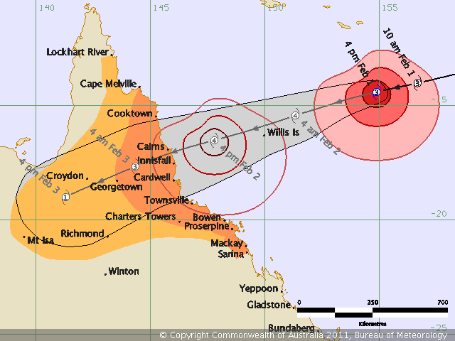
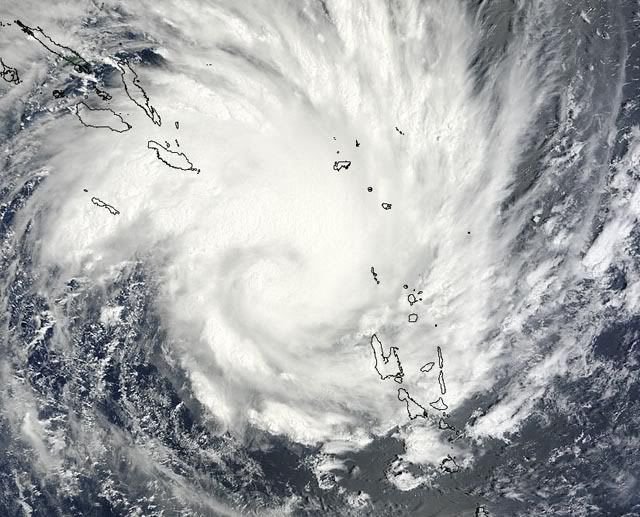
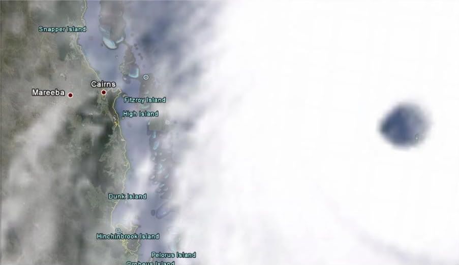
quote:Hoe groot is cycloon Yasi?
Dit beeld laat zien hoe enorm breed cycloon Yasi is. Er is een screenshot een gemaakt die ongeveer 1500 km aan kustlijn van Queensland laat zien, dat is net zo groot al geheel Nieuw-Zeeland Nieuw-Zeeland. Het beeld toont Cairns (uiterst links) en Brisbane (uiterst rechts). De cycloon zal naar verwachting net ten zuiden van Cairns aan land komen (uiterst links).

Weer of geen weer, altijd actueel www.onweer-online.nl
Omg ik hou van orkanen maar dit gaat wel boven mijn pet
Doe mee met het voorspellen van het weer!
Weekvoorspelling | Week 3 (invullen tot 16-01 - 11:59)
Maandvoorspelling Januari (Gesloten)
Jaarvoorspelling 2025 / 2026
Weekvoorspelling | Week 3 (invullen tot 16-01 - 11:59)
Maandvoorspelling Januari (Gesloten)
Jaarvoorspelling 2025 / 2026
Webcamsite van Cairns
Mogelijk vanavond (onze tijd) nog wat leuke plaatjes, dan zullen ze wel op zwart gaan
http://www.cairnsinfo.com/webcam.php
Mogelijk vanavond (onze tijd) nog wat leuke plaatjes, dan zullen ze wel op zwart gaan
http://www.cairnsinfo.com/webcam.php

quote:Yasi will be worse then Larry
Cyclone Yasi will hit the north Queensland coast with greater ferocity than devastating Cyclone Larry, according to Premier Anna Bligh.
Thousands of residents, as well as patients at Cairns hospital, face the prospect of evacuations today as the huge storm front bears down.
Latest modelling indicates the cyclone has moved slightly north and is now due to cross the coast between Tully and Lucinda, about 140 kilometres north of Townsville.
Ms Bligh, speaking after a meeting of the state disaster management group this morning, said winds of more than 250kmh could be expected from the high category four system.
By comparison Larry, which caused $1.5 billion worth of damage to Innisfail and surrounds in 2006, was a mid-level category four system.
"This of course is not only a system now tracking as more intense than Cyclone Larry, it is significantly larger than Cyclone Larry," Ms Bligh told reporters.
She said that meant areas to the north and the south of the crossing point would see effects including a high storm surge, torrential rain and destructive winds.
Low-lying areas at risk
Ms Bligh said everything possible was being done to prepare, including evacuations of low-lying areas at risk of tidal surges, and discussions with the defence force about what help they might provide.
She said gale force winds could be felt along the north Queensland coast from as early as 8am tomorrow, and warned residents in the danger zone they had a narrow window to prepare.
The size of Yasi meant many communities either side of where it made landfall could expect to see the impacts of "serious storm surges, flooding torrential rain and gale force winds", Ms Bligh said.
Ms Bligh said people must take the opportunity today to stock up on food and other supplies, with a real risk many could be without power for three to five days.
"I think many people will be very frightened by what they're hearing," she said.

Jemig wat is dat ding groot!
[b]Op maandag 6 september 2010 00:28 schreef tong80 het volgende:[/b]
GVD Wat moet jij een trotse vader zijn :)
:P
GVD Wat moet jij een trotse vader zijn :)
:P

Mooi filmpje. Je ziet Bianca, Anthony en Yasiquote:
waanzinnig om te zien hoe dat ding zich heeft ontwikkeld
Australische kuststad maakt zich op voor cycloon
(Novum/AP) - Meer dan negenduizend bewoners van de stad Cairns aan de kust van de Australische staat Queensland moeten hun huizen verlaten in verband met een 'levensbedreigende' cycloon. Dinsdag werd een ziekenhuis door het leger geëvacueerd.
De cycloon, Yasi genaamd, zal Cairns waarschijnlijk woensdagavond bereiken. Verwacht wordt dat de storm de zeespiegel twee meter zal doen stijgen en dat de stad gedeeltelijk onder water zal komen te staan. De storm bereikt snelheden van 250 kilometer per uur en gaat gepaard met zware regenval.
Cairns heeft 164 duizend inwoners. Veel mensen maakten zich dinsdag uit eigen beweging al op om te vertrekken. Omdat het vliegveld van Cairns woensdag uit voorzorg dicht gaat, regelden luchtvaartmaatschappijen voor dinsdagavond extra vluchten. Toeristen braken hun vakantie af en vlogen naar huis.
Een andere cycloon, Anthony, trof Queensland maandagmorgen, maar richtte weinig schade aan.
Yasi zal Brisbane en andere steden in Queensland die sinds november zijn getroffen door zware overstromingen niet bereiken.
Nieuws.nl
Mogelijk dat Yasi even een cat 5 cycloon wordt:
http://www.abc.net.au/lateline/content/2011/s3127339.htm
http://www.abc.net.au/lateline/content/2011/s3127339.htm
Weer of geen weer, altijd actueel www.onweer-online.nl
Zou best eens kunnen. Ze voorspellen nu 240 km/uur en windstoten tot 296 km/uur.quote:
Mogelijk dat Yasi even een cat 5 cycloon wordt:
http://www.abc.net.au/lateline/content/2011/s3127339.htm
Categorie 5 is vanaf 250 km/uur.
quote:24 HRS, VALID AT:
021200Z --- 17.1S 146.2E
MAX SUSTAINED WINDS - 130 KT, GUSTS 160 KT
WIND RADII VALID OVER OPEN WATER ONLY
[ Bericht 15% gewijzigd door #ANONIEM op 01-02-2011 15:23:38 ]
Ruimte zat in Australie zou je denkenquote:
Ik las Marrokaan.
Anyway, waar moeten al die mensen heen om zich te beschermen dan?
[b]Op maandag 6 september 2010 00:28 schreef tong80 het volgende:[/b]
GVD Wat moet jij een trotse vader zijn :)
:P
GVD Wat moet jij een trotse vader zijn :)
:P

Extremely dangerous Tropical Cyclone Yasi bears down on flooded Queensland, Australia
Tropical Cyclone Yasi continues to intensify as it speeds westwards towards vulnerable Queensland, Australia. Yasi, now a Category 4 storm with 140 mph winds, is under light wind shear of 5 - 10 knots, and over warm ocean waters of 29°C (84°C). The sea surface temperatures over the region of ocean Yasi is traversing (10S - 20S, 145E - 160E) were 1.2°C above average during December, the latest month we have data for from the UK Hadley Center. This is the highest value on record, going back to the early 1900s. Low wind shear and record warm sea surface temperatures will continue to affect Yasi for the next day, and the cyclone should be able to maintain Category 4 strength until landfall Wednesday evening (local time.)
Queensland faces three major threats from Yasi. The cyclone will bring torrential rainfall to a region with saturated soils that saw record flooding earlier this month. The latest rainfall rates in Yasi's eyewall as estimated by NASA's Tropical Rainfall Measuring Mission (TRMM) satellite are 20 mm (0.8") per hour. The GFS model is predicting that a wide swath of Queensland will receive 5 - 10 inches of rain over the next week, due to the combined effects of Yasi and a moist flow of tropical air over the region. Fortunately, Yasi is moving with a rapid forward speed, about 21 mph, and is not expected to linger over Queensland after landfall. The heaviest rainfall will miss Queenland's most populated regions to the south that had the worst flooding problems earlier this month, including the Australia's third largest city, Brisbane.
Yasi will bring highly destructive winds to a region of coast near the city of Cairns (population 150,000.) Townsville (population 200,000) is farther from the expected landfall of the eyewall, and should see lesser winds. Strong building codes have been in place in Queensland since the 1960s, which will help reduce the damage amounts.
A dangerous storm surge in excess of ten feet can be expected along the left front quadrant of the storm where it comes ashore. The critical thing will be when Yasi hits relative to the tidal cycle. The tidal range between low and high tide along the coast near Cairns will be about 2 meters (6 feet) during the evening of February 2. If Yasi hits at low tide, a 10-foot storm surge will only bring the water levels four feet above mean tide, but a strike at high tide would bring water levels a full ten feet above mean tide. High tide is at 9pm EST (local) time in Cairns on February 2.
Yasi is comparable to Cyclone Larry of 2006, which hit Queensland as a Category 4 storm with 135 mph winds. Larry killed one person and caused $872 million in damage (2011 U.S. dollars.) Yasi is a much larger storm than Larry, though, and will bring heavy rains to a region with soils already saturated from record rains. Yasi is likely to be a billion-dollar disaster for Australia.
Wunderground

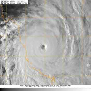
quote:Yasi is categorie 4 cycloon, mogelijk categorie 5
Cycloon Yasi heeft inmiddels categorie 4 bereikt met windsnelheden van gemiddeld 185 kilometer per uur en windstoten tot 270 kilometer per uur, maar het is ook mogelijk dat de cycloon even een categorie 5 kan gaan worden met windstoten die op kunnen gaan lopen tot 300 kilometer per uur, dat meldt het weerbureau WeatherWatch uit Nieuw-Zeeland.
Hoofd weer analist Philip Duncan zegt, "Yasi zal een spoor van verwoesting achter laten in de regio. Cyclone Wilma is maar een kleintje vergeleken bij Yasi, deze monster cycloon is ongeveer twee à drie keer de grootte van Wilma, die onlangs het noorden van Nieuw-Zeeland aan deed. Wilma was een categorie 2 cycloon en bleef ongeveer 150 kilometer uit de kust. Het bureau voor de meteorologie in Australië zegt dat er aanzienlijk veel schade zal ontstaan, daarbij moeten we denken aan dat het elektriciteitsnetwerk plat komt te liggen, daken van huizen zullen het begeven en vooral flinke schade aan de infrastructuur. Het bureau voor de meteorologie meldde ook dat er gevaarlijke vuildeeltjes in de lucht heen vliegen die zomaar iemand kunnen verwonden.
De luchtdruk is voor het laatst officieel geregistreerd op 935 hPa, maar het wordt nu geschat op zo'n 922hPa. Yasi zal na dat hij aan land is gekomen nog niet uitgeraasd zijn. De verwachting is dat de eerst komende twaalf tot 18 uur ongelooflijk zwaar weer voor gaat komen.

Weer of geen weer, altijd actueel www.onweer-online.nl
Gaat heftig worden.
Leuke radar site van Australië:
http://www.bom.gov.au/weather/radar/
En op de radarbeelden hier is die net te zien:
http://www.bom.gov.au/products/IDR191.loop.shtml#skip
Leuke radar site van Australië:
http://www.bom.gov.au/weather/radar/
En op de radarbeelden hier is die net te zien:
http://www.bom.gov.au/products/IDR191.loop.shtml#skip
Drugs are good mkay?
Maat van me woont in Cairns
Is het normaal voor een cycloon om zo laat/vroeg nog geboren te worden? Of geldt het orkaan seizoen dus alleen voor orkanen?
In Australie is het nu zomerquote:
Is het normaal voor een cycloon om zo laat/vroeg nog geboren te worden? Of geldt het orkaan seizoen dus alleen voor orkanen?
'het orkaanseizoen' zoals je dat vaak hoort geldt voor de atlantische oceaan bij Noord en centraal amerikaquote:
Is het normaal voor een cycloon om zo laat/vroeg nog geboren te worden? Of geldt het orkaan seizoen dus alleen voor orkanen?

En binnenkort nog véél meer zo te zien.quote:
[..]
Ruimte zat in Australie zou je denken
WTF, cat. 5. Gelukkig zijn de huizen in Australië niet van hout zoals dat wel zo is in Amerika.
's Avonds een man, overdags rustig an


http://www.cairnsinfo.com/webcam.php
Deze webcam is live met een achterstand van 7 min ongeveer.
Het ziet er nog redelijk rustig uit
Deze webcam is live met een achterstand van 7 min ongeveer.
Het ziet er nog redelijk rustig uit
Morgen avond bordje eten op schoot en webcams F5'nquote:
Volgens dat kaartje is de landfall ook pas over een uurtje of 18

Max wind 295 km/u.quote:
http://www.dailytelegraph(...)freuzr-1225998367005
[ afbeelding ]
[ afbeelding ]

A minor saving grace may be the fast movement of the storm, which will limit the amount of rainfall - if the storm were moving half as fast, the flooding would be even more extreme.
Vriendin van me woont in Mount Garnet, 2,5 uur vanaf de kust en precies ook waar de cycloon zwaar overheen raast, het staat zo heel fijn rood omrand op één van de eerder getoonde kaartjes...
Ik hou de berichtgeving dus in de gaten en heb haar gevraagd om te mailen als het is geweest, als het internet het nog doet enzo... Bah bah... narigheid
http://maps.google.nl/map(...).756023,4.927368&z=8
Ik hou de berichtgeving dus in de gaten en heb haar gevraagd om te mailen als het is geweest, als het internet het nog doet enzo... Bah bah... narigheid
http://maps.google.nl/map(...).756023,4.927368&z=8
Kip, het meest veelzijjjjjjjjjjjjjjjjjjjjjjjjjjjjjjjjjjjjjjjjjjjjjjjjjjjjjjjjjjjjjjjjjjjjdige stukje kaas, panda!
Internet via satelliet is nog te doen maar voor de rest kun je het wel afschaffen, daarnaast zal de stroom ook wel uitvallen.quote:Op woensdag 2 februari 2011 01:13 schreef BBQ-kip het volgende:
Vriendin van me woont in Mount Garnet, 2,5 uur vanaf de kust en precies ook waar de cycloon zwaar overheen raast, het staat zo heel fijn rood omrand op één van de eerder getoonde kaartjes...
Ik hou de berichtgeving dus in de gaten en heb haar gevraagd om te mailen als het is geweest, als het internet het nog doet enzo... Bah bah... narigheid
http://maps.google.nl/map(...).756023,4.927368&z=8
Doe mee met het voorspellen van het weer!
Weekvoorspelling | Week 3 (invullen tot 16-01 - 11:59)
Maandvoorspelling Januari (Gesloten)
Jaarvoorspelling 2025 / 2026
Weekvoorspelling | Week 3 (invullen tot 16-01 - 11:59)
Maandvoorspelling Januari (Gesloten)
Jaarvoorspelling 2025 / 2026
Kleine kans, server kan de interesse niet aan helaas.quote:
[..]
Morgen avond bordje eten op schoot en webcams F5'n
Volgens de Australische schaal is het nu een cat 5. Volgens de schaal van Saffir-Simpson is het nog net geen categorie 5.
quote:De gevolgen van de cycloon zullen gruwelijk zijn
De cycloon Yasi komt over een paar uur aan land en de gevolgen zullen rampzalig zijn, golven bereiken momenteel een hoogte van 12 meter en in combinatie met een stormvloed van 2 tot 4 meter zal dat leiden tot massale overstromingen. Een groot deel van het gebied zal naar verwachting worden getroffen door Yasi, laag gelegen krijgen te maken met ernstige overstromingen, enkele kustplaatsen zullen na verwachting verwoest worden. Yasi, een cycloon in de zwaarste categorie 5, wordt waarschijnlijk een van de grootste cycloon die Australië ooit getroffen heeft.
In de afgelopen paar uur is de wind fors in kracht toegenomen in Townsville. Yasi zal naar verwachting vanavond aan land komen ongeveer 50 à 100 kilometer ten noorden van Townsville. Overstromingen zullen ook in het binnenland voor gaan komen, de cycloon blijft intact voor meer dan 24 uur, dat is ongelooflijk zeldzaam. Zelfs orkanen in Amerika doen dit zelden. Cairns zal ook hard worden getroffen echter de de positie van de cycloon is verschoven naar het zuiden, mogelijk wordt de stad een catastrofe bespaart.
Hoofd weer analist Philip Duncan zei dat deze cycloon gebouwen zal gaan vernietigen, maar ook mensenlevens. "Er is geen twijfel over dat de monster cycloon een moordenaar is. Iedereen die in de buurt van het centrum van de cycloon zit zullen het waarschijnlijk niet overleven. Er worden windstoten verwacht tot zo'n 300 kilometer per uur, maar de stormvloed baart mij het meeste zorgen", aldus Philip Duncan.
Philip Duncan benadrukte ook dat de bevolking nog steeds de mogelijkheid heeft om naar een veilige plek te vertrekken. We zitten bijna op het punt dat de mensen de storm niet meer kunnen ontlopen.

Weer of geen weer, altijd actueel www.onweer-online.nl
Zie de openingspost van dit topicquote:
Is het normaal voor een cycloon om zo laat/vroeg nog geboren te worden? Of geldt het orkaan seizoen dus alleen voor orkanen?
Hurricane Season 2011
Kan je precies zien waar welk orkaanseizoen is. Australie zit nog wel even in de shit.. tot april met februari als piekmaand... Kunnen na Yasi zo nog maar meer orkanen volgen.
Vanmiddag bedoel jequote:
[..]
Morgen avond bordje eten op schoot en webcams F5'n
quote:30.000 geëvacueerd
De Australische deelstaat Queensland zet zich schrap voor de cycloon Yasi die naar verwachting vanmiddag, onze tijd de kust bereikt. De premier van Queensland, Anna Bligh, riep bewoners van laaggelegen kustgebieden op om een veilig heenkomen te zoeken.
"U heeft nog steeds de mogelijkheid om naar een veilige plek te vertrekken, ik kan niet genoeg benadrukken dat u van die mogelijkheid gebruik moet maken", aldus de premier. Yasi, een cycloon in de zwaarste categorie 5, wordt waarschijnlijk een van de grootste stormen die Australië ooit troffen. Onder andere de steden Cairns, Townsville en Mackay liggen in het pad van de storm.
Meer dan tienduizend mensen verblijven al in schuilplaatsen. Die zijn soms zo vol dat de politie mensen weer wegstuurt. Zo'n dertigduizend mensen hebben hun huis verlaten. Premier Bligh verwacht dat 200.000 mensen zonder stroom en telefoon komen te zitten door de storm.
Technici hebben gewaarschuwd dat zelfs de speciale stormbestendige woningen in de regio beschadigd kunnen raken door de storm, die windsnelheden bereikt tot 300 kilometer per uur. (anp/vsv)
Ik heb geen cijfers voor je, maar het overgrote deel van de Australische huizen zijn weatherboard of brick veneer. Hout dus.quote:
WTF, cat. 5. Gelukkig zijn de huizen in Australië niet van hout zoals dat wel zo is in Amerika.
Deze site heeft up-to-date nieuws en een rits links naar nog werkende webcams (zie post van 06:24):
http://www.abc.net.au/news/events/cyclone-yasi/
Het is al behoorlijk aan het spoken.
[ Bericht 6% gewijzigd door Rorsach op 02-02-2011 09:21:50 ]
http://www.abc.net.au/news/events/cyclone-yasi/
Het is al behoorlijk aan het spoken.
[ Bericht 6% gewijzigd door Rorsach op 02-02-2011 09:21:50 ]

Een rotsituatie inderdaad, vooral omdat je vanaf hier niets kunt doen. Ik maak me momenteel ongerust over een oud-klasgenootje, die amper een week geleden naar Cairns is gevlogen voor een internationale stage van een paar maanden en nu dus al flink in de penarie zit. Ze was volgens mij nog niet geëvacueerd, ik hoop dat dat snel nog gaat gebeuren, hoewel ze zelf schrijft dat de gebouwen daar, of in elk geval het hotel waarin ze verblijft, gebouwd zijn om een cycloon te kunnen weerstaan. Wat ze ook doet; ik hoop maar dat ze snel een berichtje op d'r blog plaatst dat alles goed gegaan is...quote:
Vriendin van me woont in Mount Garnet, 2,5 uur vanaf de kust en precies ook waar de cycloon zwaar overheen raast, het staat zo heel fijn rood omrand op één van de eerder getoonde kaartjes...
Ik hou de berichtgeving dus in de gaten en heb haar gevraagd om te mailen als het is geweest, als het internet het nog doet enzo... Bah bah... narigheid
http://maps.google.nl/map(...).756023,4.927368&z=8
Charlie, listen to me. Kill the kid, torch the house, we gotta get out of here.
Thx!quote:
Deze site heeft up-to-date nieuws en een rits links naar nog werkende webcams:
http://www.abc.net.au/news/events/cyclone-yasi/
Het is al behoorlijk aan het spoken.


quote:Australia Buro Of Meteorology says Willis Island observation station may have been destroyed. No data for over 40 minutes.
quote:Category five Cyclone Yasi has knocked out the weather bureau's radar system on Willis Island, about 450 kilometres east of Cairns in far north Queensland.
The weather bureau's radar and wind speed measurements on the island failed just before 9am (AEST).
The bureau says the maximum wind speed recorded before the equipment went down was 185 kilometres per hour.
Three weather observers and a technician left the island yesterday

30.000 Aussies hebben huis verlaten voor cycloon Yasi
Aussies wachten in sportzalen samen de komst af van cycloon Yasi. © epa
De Australische deelstaat Queensland zet zich schrap voor de cycloon Yasi die naar verwachting vanmiddag, onze tijd de kust bereikt. De premier van Queensland, Anna Bligh, riep bewoners van laaggelegen kustgebieden op om een veilig heenkomen te zoeken.
"U heeft nog steeds de mogelijkheid om naar een veilige plek te vertrekken, ik kan niet genoeg benadrukken dat u van die mogelijkheid gebruik moet maken", aldus de premier. Yasi, een cycloon in de zwaarste categorie 5, wordt waarschijnlijk een van de grootste stormen die Australië ooit troffen. Onder andere de steden Cairns, Townsville en Mackay liggen in het pad van de storm.
Meer dan tienduizend mensen verblijven al in schuilplaatsen. Die zijn soms zo vol dat de politie mensen weer wegstuurt. Zo'n dertigduizend mensen hebben hun huis verlaten. Premier Bligh verwacht dat 200.000 mensen zonder stroom en telefoon komen te zitten door de storm.
Technici hebben gewaarschuwd dat zelfs de speciale stormbestendige woningen in de regio beschadigd kunnen raken door de storm, die windsnelheden bereikt tot 300 kilometer per uur. (anp/vsv)


Water staat nu al hoog en het ergste moet nog komen. Stormvloed van meer dan 5.5 meter.quote:
Sommige mensen vragen ook wel om problemen.
En het oog is goed te zien op de radar:
http://www.bom.gov.au/products/IDR192.loop.shtml#skip
Webcam met wel heel lage FPS, maar wel geluid:
http://www.ustream.tv/channel/cyclone-yasi---cairns-beaches
Gaat heftig worden daar
http://www.bom.gov.au/products/IDR192.loop.shtml#skip
Webcam met wel heel lage FPS, maar wel geluid:
http://www.ustream.tv/channel/cyclone-yasi---cairns-beaches
Gaat heftig worden daar
Drugs are good mkay?
Oog is 35km groot en zal een uur kunnen duren voor ie voorbij getrokken is, mensen worden dus gewaarschuwd niet te denken dat het voorbij is als het kalmeert.

En dan zie je maar weer dat dit niks is vergeleken met Katrina qua omvang
Doe mee met het voorspellen van het weer!
Weekvoorspelling | Week 3 (invullen tot 16-01 - 11:59)
Maandvoorspelling Januari (Gesloten)
Jaarvoorspelling 2025 / 2026
Weekvoorspelling | Week 3 (invullen tot 16-01 - 11:59)
Maandvoorspelling Januari (Gesloten)
Jaarvoorspelling 2025 / 2026
Qua omvang misschien niet, maar deze is krachtiger.quote:
En dan zie je maar weer dat dit niks is vergeleken met Katrina qua omvang
I am unconditionally and irrevocably in love with him.
I'm 97% sure you don't like me, I'm 100% sure I don't care.
I'm 97% sure you don't like me, I'm 100% sure I don't care.
Innisfail krijgt de volle laag en Georgetown, zon 275 kilometers landinwaarts krijgt nog cat.3 orkaankrachtquote:TOP PRIORITY
TROPICAL CYCLONE ADVICE NUMBER 20
Issued by the Bureau of Meteorology, Brisbane
Issued at 8:07pm EST on Wednesday the 2nd of February 2011
A Cyclone WARNING is current for coastal and island communities from Cape
Flattery to Sarina , extending west across the tropical interior to the Northern
Territory border.
At 8:00 pm EST Severe Tropical Cyclone Yasi, Category 5 was estimated to be 165
kilometres east southeast of Cairns and 135 kilometres east northeast of
Innisfail and moving west southwest at 26 kilometres per hour.
THE VERY DESTRUCTIVE CORE OF CYCLONE YASI WILL CROSS THE COAST NEAR INNISFAIL
CLOSE TO MIDNIGHT, WITH A DANGEROUS STORM TIDE AND BATTERING WAVES SOUTH OF THE
CYCLONE CENTRE.
Tropical Cyclone Yasi, CATEGORY 5, will continue to move in a west-southwesterly
direction and is expected to cross the coast near Innisfail close to midnight.
Coastal residents between Cairns and Ayr are specifically warned of an EXTREMELY
DANGEROUS SEA LEVEL RISE [i.e. storm tide] as the cyclone approaches, crosses
the coast and moves inland.
Higher than normal tides will exceed the high water mark with damaging waves and
flooding in low lying areas in remaining warning areas to the south of Ayr.
VERY DESTRUCTIVE winds with gusts up to 290 km/h are expected to develop between
Cairns and Ingham during the next few hours as the cyclone approaches. These
VERY DESTRUCTIVE winds will extend inland to the nearby ranges including the
Atherton Tablelands.
Due to the large size of the cyclone, people in the path of the VERY DESTRUCTIVE
WINDS are likely to experience these conditions for about 3 to 4 hours.
DESTRUCTIVE winds with gusts in excess of 125 km/h between Cape Tribulation and
Ayr are expected to spread inland overnight.
DAMAGING WINDS with gusts to 90 km/hr are occurring in remaining coastal areas
between Cape Flattery and Sarina, and are forecast to spread inland and west to
Mt Isa during Thursday.
Winds are forecast to gradually ease about the east coast during Thursday
morning as the cyclone moves inland.
FLOODING RAINS will develop from Cooktown to Sarina tonight and gradually extend
inland.
People in the path of the very dangerous cyclone should stay calm and remain in
a secure shelter, above the expected water level, while the very destructive
winds continue.
- Do not venture outside if you find yourself in the eye of the cyclone; very
destructive winds from a different direction could resume at any time.
- Follow the evacuation advice or directions of Police, Emergency Services
personnel and local authorities.
People in remaining areas between Cape Flattery and Sarina and extending west
across the tropical interior to the Northern Territory border, should complete
preparations quickly and be prepared to shelter in a safe place.
- Boats and outside property should be secured.
- For cyclone preparedness and safety advice, visit Queensland's Disaster
Management Services website [www.disaster.qld.gov.au]
- For emergency assistance call the Queensland State Emergency Service [SES] on
132 500 [for assistance with storm damage, rising flood water, fallen trees on
buildings or roof damage].
Details of Severe Tropical Cyclone Yasi at 8:00 pm EST:
.Centre located near...... 17.2 degrees South 147.3 degrees East
.Location accuracy........ within 20 kilometres
.Recent movement.......... towards the west southwest at 26 kilometres per hour
.Wind gusts near centre... 285 kilometres per hour
.Severity category........ 5
.Central pressure......... 930 hectoPascals
Please ensure that neighbours have heard and understood this message,
particularly new arrivals or those who may not fully understand English.
The next advice will be issued by 9:00 pm EST Wednesday 02 February.
This warning is also available through TV and Radio Broadcasts; the Bureau's
website at www.bom.gov.au or call 1300 659 212. The Bureau and the State
Emergency Service would appreciate this warning being broadcast regularly.
Hij is nu ongeveer aan land?
I am unconditionally and irrevocably in love with him.
I'm 97% sure you don't like me, I'm 100% sure I don't care.
I'm 97% sure you don't like me, I'm 100% sure I don't care.
WTF Komt de stormsurge ook nog samen met hoogtij?quote:MARK COLVIN: Cyclone Yasi is expected to set off storm surges around three metres above the normal high tide in Townsville from where our reporter Stephanie Smail joins us now.
Stephanie what will that mean?
STEPHANIE SMAIL: Mark, storm surges three metres above a high tide which is expected to reach four metres, means seven metres of water could be flowing through some suburbs of Townsville later tonight.
It's hoped that the high tide will peak and then go down before the cyclone crosses the coast but if that's not the case, then it's unknown what really could happen but up to 10,000 homes could be inundated according to local authorities.
check ff de rainfallquote:
En dan zie je maar weer dat dit niks is vergeleken met Katrina qua omvang
1000 mm predicted voor Yasi, net zoveel als Katrina
Echt je zou daar wonen. Je moet gewoon je huis uit met het idee dat als je terugkeert er helemaal niets meer is. Je huis weg, je spullen...
I am unconditionally and irrevocably in love with him.
I'm 97% sure you don't like me, I'm 100% sure I don't care.
I'm 97% sure you don't like me, I'm 100% sure I don't care.
quote:Bligh: #tcyasi warns about storm surge; the high tide in half hour's time, will add to storm surge. There will also be high tide 9.30am
Zo klote dat ik nu geen geluid heb om dat ABC te volgen
Als de complete orkaan nu boven West Europa zou liggen, ziet dat er zo uit
Als de complete orkaan nu boven West Europa zou liggen, ziet dat er zo uit

WTF hee, dat geeft wel aan hoe groot dat ding toch is!
En 1000 mm regenval is echt sick.
En 1000 mm regenval is echt sick.
's Avonds een man, overdags rustig an
Dat is mooi dacht ikquote:
Livestream: Townsville/queensland
http://www.ustream.tv/channel/caillins13
Aii dat kan nog eens lastig wordenquote:
Doe mee met het voorspellen van het weer!
Weekvoorspelling | Week 3 (invullen tot 16-01 - 11:59)
Maandvoorspelling Januari (Gesloten)
Jaarvoorspelling 2025 / 2026
Weekvoorspelling | Week 3 (invullen tot 16-01 - 11:59)
Maandvoorspelling Januari (Gesloten)
Jaarvoorspelling 2025 / 2026
http://www.ssd.noaa.gov/mtsat/flt/t1/flash-avn.htmlquote:Latest satellite loop seems to show Yasi strengthening. Deepest convection starting to wrap mst of way around eye
Wordt ie nou nog sterker?
Maar waar is West-Europa dan?quote:
Zo klote dat ik nu geen geluid heb om dat ABC te volgen
Als de complete orkaan nu boven West Europa zou liggen, ziet dat er zo uit
[ afbeelding ]
@SpeedyGJ
wel wat voor jou, deze weerdata uit Cairns
check die temperatuurs- en drukverschillen in de afgelopen 24 uur
http://cairnsweathercam.com.au/weather-display-live.php
wel wat voor jou, deze weerdata uit Cairns
check die temperatuurs- en drukverschillen in de afgelopen 24 uur
http://cairnsweathercam.com.au/weather-display-live.php
Die temperatuurdaling van 6 graden, is dat overdag? En de luchtdruk is ook behoorlijk gedaald idd... ruim 20 hPa in 24 uur. Er staat ook een leuk briesjequote:
@SpeedyGJ
wel wat voor jou, deze weerdata uit Cairns
check die temperatuurs- en drukverschillen in de afgelopen 24 uur
http://cairnsweathercam.com.au/weather-display-live.php
Ik zie NL/Belg liggen....ik praat altijd zo leuk maar als je dit dan op je af ziet komen in het echtquote:
Zo klote dat ik nu geen geluid heb om dat ABC te volgen
Als de complete orkaan nu boven West Europa zou liggen, ziet dat er zo uit
[ afbeelding ]
Even goed kijken, je ziet NL in het blauwe gedeelte zitten ten westen van het oog.quote:
Het lijkt er wel op...quote:
[..]
http://www.ssd.noaa.gov/mtsat/flt/t1/flash-avn.html
Wordt ie nou nog sterker?
Dank je zal eens gaan kijkenquote:
@SpeedyGJ
wel wat voor jou, deze weerdata uit Cairns
check die temperatuurs- en drukverschillen in de afgelopen 24 uur
http://cairnsweathercam.com.au/weather-display-live.php
Nog ammateurmetingen?
Doe mee met het voorspellen van het weer!
Weekvoorspelling | Week 3 (invullen tot 16-01 - 11:59)
Maandvoorspelling Januari (Gesloten)
Jaarvoorspelling 2025 / 2026
Weekvoorspelling | Week 3 (invullen tot 16-01 - 11:59)
Maandvoorspelling Januari (Gesloten)
Jaarvoorspelling 2025 / 2026
Ten westen van het oog is wel veel blauw, maar da's oceaanquote:
Even goed kijken, je ziet NL in het blauwe gedeelte zitten ten westen van het oog.
Oeps ik bedoel ten oostenquote:
[..]
Ten westen van het oog is wel veel blauw, maar da's oceaan
Doe mee met het voorspellen van het weer!
Weekvoorspelling | Week 3 (invullen tot 16-01 - 11:59)
Maandvoorspelling Januari (Gesloten)
Jaarvoorspelling 2025 / 2026
Weekvoorspelling | Week 3 (invullen tot 16-01 - 11:59)
Maandvoorspelling Januari (Gesloten)
Jaarvoorspelling 2025 / 2026
Op Twitter komen eerste berichten over schade
-Stroom uitgevallen op Magnetic eiland voor de kust
-flikkerende lichten in Cairns
en dingen als
http://www.google.nl/imag(...)=wi&biw=1024&bih=583
-Stroom uitgevallen op Magnetic eiland voor de kust
-flikkerende lichten in Cairns
en dingen als
Net ff gegoogled... mag niet hopen dat zelfs dat soort gebouwen nu al kapot gaanquote:Reports of roof starting to lift off the Urban Quarter building in Townsvill
http://www.google.nl/imag(...)=wi&biw=1024&bih=583
Een vriendin van me zou vandaag vanuit Cairns terugvliegen naar NL, maar is geevacueerd naar een winkelcentrum. Zal er eens smsen hoe het ervoor staat nu.
Hallo NOSquote:Eerste schade orkaan in Australië
De orkaan Yasi heeft de eerste schade aangericht in Australië. Vanuit het dorp Innisfail in het noorden van Queensland komen berichten dat er daken van huizen zijn gerukt en bomen zijn omgewaaid.
Het oog van de orkaan wordt verwacht in de loop van de middag (Nederlandse tijd), als het in Australië nacht is. Het advies aan bewoners is om binnen te blijven, omdat het te gevaarlijk is om nog te vluchten.
Yasi wordt waarschijnlijk een van de zwaarste stormen in de geschiedenis van Australië. Er worden windsnelheden van 300 km/u verwacht. Tienduizenden mensen zijn hun huis ontvlucht.


Weet niet of deze foto 'echt' is... maar...

quote:Wednesday: Cyclone Yasi is the strongest threat ever remembered to Australia, It is at the speed of 555km east of Cairns and 560km northeast of Townsville. It has winds of up to 295 km/h at its centre.
Massive destruction and deaths can happen, its just the matter of time that we can actually see the giant Cyclone on land.
It is a category five storm and is expected to be the largest to ever hit the continent.
Officials have urged the residents to Immediately evacuate before the mighty Cyclone hits Queensland.Many residents of the area had to take shelter last March when a Category 3 Tropical Cyclone Ului barreled in. But that storm has no comparison to the strength that Cyclone Yasi bags.
Ze zit nu 14u in de shopping mall, stroom viel net ff uit, maar verder merkt ze er nog weinig van zegt ze.
http://www.ustream.tv/cha(...)68&utm_medium=social
http://werdjs.blogspot.com/2011/02/cyclone-yasi.html
http://werdjs.blogspot.com/2011/02/cyclone-yasi.html
I am unconditionally and irrevocably in love with him.
I'm 97% sure you don't like me, I'm 100% sure I don't care.
I'm 97% sure you don't like me, I'm 100% sure I don't care.
Wel lekker zoveel wind bij temperaturen tussen 25°C en 30°Cquote:
@SpeedyGJ
wel wat voor jou, deze weerdata uit Cairns
check die temperatuurs- en drukverschillen in de afgelopen 24 uur
http://cairnsweathercam.com.au/weather-display-live.php
Nog een klein uur dacht ik dan komt het oog aan landquote:
Ze zit nu 14u in de shopping mall, stroom viel net ff uit, maar verder merkt ze er nog weinig van zegt ze.
Sterkte

Haha, wat heeft die foto met een cycloon te maken?quote:
Weet niet of deze foto 'echt' is... maar...
[ afbeelding ]
[..]
's Avonds een man, overdags rustig an
Zieke shit, ik blijf ff kijken.
A man said to the universe: 'Sir, I exist.'
'However', replied the universe. 'This fact has not created in me a sense of obligation.'
'However', replied the universe. 'This fact has not created in me a sense of obligation.'
Ik weet niet wat dat voor stormcomplex is voor dat bootje, maar ik zou er niet heel vrolijk van worden.quote:
[..]
Haha, wat heeft die foto met een cycloon te maken?
Duurt nog wel een paar uur.quote:
[..]
Nog een klein uur dacht ik dan komt het oog aan land
Sterkte

Gruwelijk 
|| FOK!Stok || tatatatatataatatatattaaaaapiediedieuwtididipieuwpidibididi She said I'll throw myself away pididididum They're just photos after all! || Den Helder || Winnaar VBL Wijndal-award 2020: beste AZ-user! || Mijn concertstatistieken ||

Hoe laat komt ie aan land? NL tijd..
|| FOK!Stok || tatatatatataatatatattaaaaapiediedieuwtididipieuwpidibididi She said I'll throw myself away pididididum They're just photos after all! || Den Helder || Winnaar VBL Wijndal-award 2020: beste AZ-user! || Mijn concertstatistieken ||
Dr wordt gezegd dat dat een foto vanaf een tanker is, met uitzicht op Yasiquote:
[..]
Haha, wat heeft die foto met een cycloon te maken?
maar onbevestigd, lijkt me namelijk een 'simpele' onweerswolk. Maar goed, geen idee
Tussen 1500-1600 uur denk ikquote:Op woensdag 2 februari 2011 13:31 schreef Dagoduck het volgende:
Hoe laat komt ie aan land? NL tijd..
townsville: http://www.ustream.tv/channel/cyclone-yasi-townsville
Cairns: http://www.ustream.tv/channel/cyclone-yasi-cairns-cbd
Cairns: http://www.ustream.tv/channel/cyclone-yasi-cairns-cbd
I am unconditionally and irrevocably in love with him.
I'm 97% sure you don't like me, I'm 100% sure I don't care.
I'm 97% sure you don't like me, I'm 100% sure I don't care.
quote:Queensland Premier Anna Bligh says 89,000 houses are currently without power
quote:Bligh: Reports of 18m wave in Townsville not accurate
quote:Waves of 9.5 metres reported off Townsville as Cyclone Yasi approaches
Stormchaserreports via Twitter
quote:The winds are roaring like a freight train here. Unbelievable. We're bunkered down. #TCYasi
quote:These winds are forecast to get stronger as the peak is still two hours away. #TCYasi
quote:Eyewall is 50km away at 70 degrees from our position
Die twitterberichten zijn ook wel bizar, 1 op 1 getuigenissen enzo...quote:
townsville: http://www.ustream.tv/channel/cyclone-yasi-townsville
Cairns: http://www.ustream.tv/channel/cyclone-yasi-cairns-cbd
quote:ABCnorthqld | 2 mins ago
Rain seems to have changed direction in Airlie Beach - now hitting the side windows. Anyone else notice a change ? #TCYasi
I give myself very good advice
But I very seldom follow it
That explains the trouble that I'm always in
But I very seldom follow it
That explains the trouble that I'm always in
1:51 Traiteri: outside probably CAT 1 or 2, inside nice and safe and dry, no problems
Uit de chats bij de webcam..
Uit de chats bij de webcam..
I am unconditionally and irrevocably in love with him.
I'm 97% sure you don't like me, I'm 100% sure I don't care.
I'm 97% sure you don't like me, I'm 100% sure I don't care.
Wij zitten een radio ABC far North Queensland te luisteren, die zitten in Cairns en zagen net een krokodil van over twee meter voorbij komen...
De cycloon en water zijn 1 probleem, een volgend probleem is dat na de storm er ineens krokodillen op de meest vreemde plekken opduiken. En North Queensland heeft een enorme populatie krokodillen.
http://www.abc.net.au/farnorth/
Die geven nu continu live reports van de mensen in Cairns.
De cycloon en water zijn 1 probleem, een volgend probleem is dat na de storm er ineens krokodillen op de meest vreemde plekken opduiken. En North Queensland heeft een enorme populatie krokodillen.
http://www.abc.net.au/farnorth/
Die geven nu continu live reports van de mensen in Cairns.
Record brekende golf bij Townsville
Afgelopen nacht heeft wederom een golf het hoogterecord verbroken bij Townsville, terwijl uren daarvoor het record al eerder gesneuveld was. Op woensdagmorgen is een golf van 6.6 meter hoog bij de kust van Townsville waargenomen. Dit was toen de hoogste golf, die sinds het aanleggen van het hoogte-register begin jaren '70, werd waargenomen. Slechts enkele uren hierna werd het prille record verpulverd door een golf met een gigantische hoogte van 9.5 meter. De verwachting is, dat de golven zullen blijven groeien gedurende de komende uren. Echter lijkt de cycloon iets in treksnelheid te hebben afgenomen, wat gunstig is voor het gebied bij Townsville. Het getijde is nu landafwaarts en de cycloon zal bij laagtij aan land komen, waardoor het effect van een vloedgolf wordt verminderd. Echter een lagere snelheid betekent ook meer hevige neerslag en zal het gebied langer door hurricane winden worden getroffen, wat weer meer kans geeft op catastrofale schade.
De cycloon blijft een krachtige categorie 5 cycloon met windstoten oplopend tot 285km/h. WeatherWatch.co.nz schat in, dat de cycloon nu zich zo'n 80 kilometer van de kustlijn bevindt en meer dan 2000 kilometer breed is. In het afgelopen uur hebben windstoten Townsville getroffen met een snelheid van 104km/h. Op het moment van schrijven heeft de storm Cairns nog niet bereikt.
©onweer-online
Weer of geen weer, altijd actueel www.onweer-online.nl
Jammer dat Egypte alle aandacht van de FP krijgt...dit kan een catastrofe worden, wordt mijns inziens te weinig op gereageerd. Maar ja, bekend verhaal inmiddels
Ik weet niet of deze site al eens voorbij is gekomen: http://www.theaustralian.(...)7il3q4-1225998711771
Hier komen iig steeds updates binnen. Pff.. wat een storm zeg.
Hier komen iig steeds updates binnen. Pff.. wat een storm zeg.
be nice or go away

Hier kun je live naar chasers luisteren, beeld is er niet maar ze zenden wel uit: http://www.ustream.tv/cha(...)68&utm_medium=social
be nice or go away
Ach is bekend, schrijf me de laatste 2 dagen de velle daar over en blijft daar 2 dagen in de wachtrij staan. Hebben ze het nieuws eerder dan ANP en dan doen ze er niets mee, best frustrerend is datquote:
Jammer dat Egypte alle aandacht van de FP krijgt...dit kan een catastrofe worden, wordt mijns inziens te weinig op gereageerd. Maar ja, bekend verhaal inmiddels
Weer of geen weer, altijd actueel www.onweer-online.nl
Kijk die barometer gaan!
I am unconditionally and irrevocably in love with him.
I'm 97% sure you don't like me, I'm 100% sure I don't care.
I'm 97% sure you don't like me, I'm 100% sure I don't care.
 Op
Op
Ik tel drie tornado's rondom een vager middengebied. Geen idee of dat standaard is voor je simpele onweerswolk.quote:
[..]
Dr wordt gezegd dat dat een foto vanaf een tanker is, met uitzicht op Yasi
maar onbevestigd, lijkt me namelijk een 'simpele' onweerswolk. Maar goed, geen idee
Ik kan me niet voorstellen dat iemand nog op stap gaat om die te tellen, Scorpie. Wat er precies allemaal is gebeurd, zal pas morgenochtend duidelijk worden denk ik...
Dat is overal zo. Ga maar op nu.nl kijken bv.quote:
Jammer dat Egypte alle aandacht van de FP krijgt...dit kan een catastrofe worden, wordt mijns inziens te weinig op gereageerd. Maar ja, bekend verhaal inmiddels
Die werd boven al gegeven.quote:
I am unconditionally and irrevocably in love with him.
I'm 97% sure you don't like me, I'm 100% sure I don't care.
I'm 97% sure you don't like me, I'm 100% sure I don't care.
ik zit deze te kijken : http://www.ustream.tv/channel/cyclone-yasi-townsville
Gaat diegene die het streamt gewoon naar buiten om de camera schoon te maken. Mafkees.
Gaat diegene die het streamt gewoon naar buiten om de camera schoon te maken. Mafkees.
I am unconditionally and irrevocably in love with him.
I'm 97% sure you don't like me, I'm 100% sure I don't care.
I'm 97% sure you don't like me, I'm 100% sure I don't care.
Dat is een bekend gegeven voor een Hurricane: http://en.wikipedia.org/wiki/Hurricane_Katrina_tornado_outbreakquote:
[..]
Ik tel drie tornado's rondom een vager middengebied. Geen idee of dat standaard is voor je simpele onweerswolk.
Onstabiele lucht voor een orkaan uit, daar kunnen tornadoes in zitten.
be nice or go away
Maar die foto die Frutsel liet zien is niet afkomstig van Yasi, circuleert al enige tijd op internet
Weer of geen weer, altijd actueel www.onweer-online.nl
Ik wilde enkel zeggen dat het wel een foto kan zijn van de buitenkant van een orkaan, Fruts dacht dat het een simpele onweerswolk was toch?quote:
Maar die foto die Frutsel liet zien is niet afkomstig van Yasi, circuleert al enige tijd op internet
be nice or go away
Ik bedoelde dan ook dat ik de indruk had dat het meer was dan een simpele onweersbui. Of het wel of niet Yasi is, kan ik niet zien. Maar 'k zou toch proberen weg te varen van die bui ipv er naar toe.quote:Op woensdag 2 februari 2011 14:12 schreef kahaarin het volgende:
[..]
Dat is een bekend gegeven voor een Hurricane: http://en.wikipedia.org/wiki/Hurricane_Katrina_tornado_outbreak
Onstabiele lucht voor een orkaan uit, daar kunnen tornadoes in zitten.
Dat lijkt me ook een gezonde reactie.quote:
[..]
Ik bedoelde dan ook dat ik de indruk had dat het meer was dan een simpele onweersbui. Of het wel of niet Yasi is, kan ik niet zien. Maar 'k zou toch proberen weg te varen van die bui ipv er naar toe.
Hier begint de varanda behoorlijk te rammelen, het is toch ongeveer tijd voor de eyewall nu?
http://www.ustream.tv/channel/cyclone-yasi-townsville
be nice or go away
Nietes! Je quotte niet!quote:
Ik reageer daarom ook op frutsel zijn post
be nice or go away
Het zal nu nog iets meer dan een uur duren voor het land raakt. Het is nu ongeveer kwart voor 11 daar, de verwachting is dat het middernacht aankomt.
quote:2 February, 2011 10:42PM AEST
Tropical Cyclone Yasi nears the coast
Severe tropical cyclone Yasi, category five, is expected to cross the coast near Mission Beach close to midnight. While extremely dangerous sea levels are expected between Cairns and Ayr, with tides predicted to exceed the high water mark with damaging waves. Flood warnings have also been issued for rivers and creeks south of the cyclone.
Ik heb het idee dat die camera gewoon binnenstaat, je ziet vlekken van een ruit oid...quote:
ik zit deze te kijken : http://www.ustream.tv/channel/cyclone-yasi-townsville
Gaat diegene die het streamt gewoon naar buiten om de camera schoon te maken. Mafkees.
I give myself very good advice
But I very seldom follow it
That explains the trouble that I'm always in
But I very seldom follow it
That explains the trouble that I'm always in
Ik zit met de chats mee te lezen daar wordt een half uurtje gezegd tot ie aan land gaat.
I am unconditionally and irrevocably in love with him.
I'm 97% sure you don't like me, I'm 100% sure I don't care.
I'm 97% sure you don't like me, I'm 100% sure I don't care.
Dat is de lens.quote:
[..]
Ik heb het idee dat die camera gewoon binnenstaat, je ziet vlekken van een ruit oid...
I am unconditionally and irrevocably in love with him.
I'm 97% sure you don't like me, I'm 100% sure I don't care.
I'm 97% sure you don't like me, I'm 100% sure I don't care.
Ja he? Echt wat een mafkees.quote:
[..]
Idd, de cam werd net afgepoetst door de streamer.
I am unconditionally and irrevocably in love with him.
I'm 97% sure you don't like me, I'm 100% sure I don't care.
I'm 97% sure you don't like me, I'm 100% sure I don't care.
Zou ook kunnen. Maar de camera staat wel heel stil. En dat stuk plastic midden boven, dat beweegt ook niet.quote:
(Niet dat het veel uitmaakt hoor, offie binnen of buiten staat, maar dan maakt het de eigenaar iets minder mafkees
I give myself very good advice
But I very seldom follow it
That explains the trouble that I'm always in
But I very seldom follow it
That explains the trouble that I'm always in
Hmm, en de orkaan is er nog niet eens, ik vrees voor die varanda, die rammelt nu al behoorlijk af en toe....quote:
be nice or go away
Deze camera (en het huis dus) is 200km verwijderd van waar het oog langs zal trekken.. Ik hoop voor ze dat het blijft staan, of ik ben live getuige 
I am unconditionally and irrevocably in love with him.
I'm 97% sure you don't like me, I'm 100% sure I don't care.
I'm 97% sure you don't like me, I'm 100% sure I don't care.
Ja, daar ben ik ook bang voor... Ik snap niet waarom de bewoners thuis blijven. Zou ik niet durven denk ik.quote:
Deze camera (en het huis dus) is 200km verwijderd van waar het oog langs zal trekken.. Ik hoop voor ze dat het blijft staan, of ik ben live getuige
Ligt het aan mij of wordt de wind harder? Wat denk jij?
Lol, hij staat nu buiten....
be nice or go away
Ja de wind is zeker al harder gaan waaien..quote:
[..]
Ja, daar ben ik ook bang voor... Ik snap niet waarom de bewoners thuis blijven. Zou ik niet durven denk ik.
Ligt het aan mij of wordt de wind harder? Wat denk jij?
Ik weet niet wat ik zou doen, ik denk mn spullen pakken, dieren inladen en rijden maar. Weg.
I am unconditionally and irrevocably in love with him.
I'm 97% sure you don't like me, I'm 100% sure I don't care.
I'm 97% sure you don't like me, I'm 100% sure I don't care.
Precies, zo ver mogelijk bij het pad van Yasi vandaan iig.....quote:
[..]
Ja de wind is zeker al harder gaan waaien..
Ik weet niet wat ik zou doen, ik denk mn spullen pakken, dieren inladen en rijden maar. Weg.
be nice or go away
Haal je dat nog ,op de radio werd aanbevolen thuis te blijvenquote:Op woensdag 2 februari 2011 14:43 schreef kahaarin het volgende:
[..]
Precies, zo ver mogelijk bij het pad van Yasi vandaan iig.....
het is te laat ,het is te laat
Klopt, ze waarschuwen al sinds gisteren dat iedereen het beste weg kan gaan, mensen worden in sporthallen opgevangen, dat doen ze natuurlijk niet voor niets. Heel eigenwijs sommigen.quote:
[..]
Haal je dat nog ,op de radio werd aanbevolen thuis te blijven
het is te laat ,het is te laat
be nice or go away
Nee, nu is het telaat, maar ze wisten al een tijdje dat dit monster eraan kwam. Ik zou echt wegwezen.quote:
[..]
Haal je dat nog ,op de radio werd aanbevolen thuis te blijven
het is te laat ,het is te laat
I am unconditionally and irrevocably in love with him.
I'm 97% sure you don't like me, I'm 100% sure I don't care.
I'm 97% sure you don't like me, I'm 100% sure I don't care.

Op de radio zeggen ze inderdaad dat het te laat is. Als je nu gaat reizen en er gebeurt iets is er niemand die je komt helpen. Politie en ambulances rijden niet meer uit ivm het gevaar op de weg.quote:
[..]
Haal je dat nog ,op de radio werd aanbevolen thuis te blijven
het is te laat ,het is te laat
Zo dan, check die wind
edit: die hele veranda bewoog
edit: die hele veranda bewoog
|| FOK!Stok || tatatatatataatatatattaaaaapiediedieuwtididipieuwpidibididi She said I'll throw myself away pididididum They're just photos after all! || Den Helder || Winnaar VBL Wijndal-award 2020: beste AZ-user! || Mijn concertstatistieken ||
Ja idd, ik denk dat Yasi de kust heeft gevonden inmiddels....quote:
Zo dan, check die wind
edit: die hele veranda bewoog
be nice or go away
quote:Breaking News
Australia's Cyclone Yasi may destroy even "cyclone proof" homes
Australia's Cyclone Yasi, with winds of up to 300 km (186 miles) per hour, is so powerful it could blow apart even "cyclone proof" houses, engineers said on Wednesday.
Yasi is headed for major towns and cities along the northeast coast. It is believed to be the strongest ever to hit Australia, surpassing Cyclone Tracy which largely destroyed the northern city of Darwin in 1974.
"Once you get to extreme cases, you are in uncharted ground and the test data I have got I would not trust it if I had to live there myself," said Dr Robert Leicester, a researcher with the government's national scientific research body.
Leicester, of the Commonwealth Scientific and Industrial Research Organisation, has studied the impact of Australia's two previous worst cyclones, Tracy and Cyclone Larry in 2006.
"Of the cyclones up to now since Tracy, you have not really had a direct hit on places with a lot of housing," he said.
Building standards have been tightened significantly since Tracy killed 71 people and destroyed about 70 percent of the northern city of Darwin.
But they may be no match for cyclones the size of Yasi. Standards are already being reviewed because of worries that cyclones are getting stronger and moving further south.
Engineers said that while most modern homes were designed to withstand high wind-speeds, pressures were different during a severe cyclone which could suck walls out and blow roofs off buildings.
Structures in the region built before 2002 were designed to withstand winds of 252 kph and those built since then for winds of 265 kph, according to Professor Mark Bradford, of the University of New South Wales' School of Civil and Environmental Engineering.
Smaller building are particularly vulnerable. "It doesn't look particularly good, it is quite scary."
But Bradford said larger steel-reinforced structures such as high-rise buildings and bridges were expected to withstand the cyclone. Ports and refineries were also expected to be undamaged.
Inderdaad, maar dan wel een dag eerderquote:
[..]
Nee, nu is het telaat, maar ze wisten al een tijdje dat dit monster eraan kwam. Ik zou echt wegwezen.
Lijkt me ontzettend angstig als je daar nu nog bent...
Oh noes, hij zegt wel zo mooi dat zijn huis heel stevig is maar na dat laatste bericht help ik het hem hopen....
be nice or go away
Hij zit natuurlijk wel 200km van het oog. Maar toch .
Ik vind dit zo naar, je weet gewoon vooraf al dat er slachtoffers gaan vallen.
Ik vind dit zo naar, je weet gewoon vooraf al dat er slachtoffers gaan vallen
Tully / 18m/s volgens meteogram.quote:
Landfall nu, goed te zien op deze radar
http://www.bom.gov.au/products/IDR192.loop.shtml#skip
Doe mee met het voorspellen van het weer!
Weekvoorspelling | Week 3 (invullen tot 16-01 - 11:59)
Maandvoorspelling Januari (Gesloten)
Jaarvoorspelling 2025 / 2026
Weekvoorspelling | Week 3 (invullen tot 16-01 - 11:59)
Maandvoorspelling Januari (Gesloten)
Jaarvoorspelling 2025 / 2026
Als je deze radarbeelden bekijkt:quote:
Oh noes, hij zegt wel zo mooi dat zijn huis heel stevig is maar na dat laatste bericht help ik het hem hopen....
http://www.bom.gov.au/products/IDR192.loop.shtml
Dan zie je onderaan 'Ingham' en die camera/het huis staan nog eens 100km verder van het oog af. Men... kan me niet voorstellen hoe het er dichterbij aan toegaat,.
Zo idd! Dat is best nog ver weg van alle ellende..quote:
[..]
Als je deze radarbeelden bekijkt:
http://www.bom.gov.au/products/IDR192.loop.shtml
Dan zie je onderaan 'Ingham' en die camera/het huis staan nog eens 100km verder van het oog af. Men... kan me niet voorstellen hoe het er dichterbij aan toegaat,.
I am unconditionally and irrevocably in love with him.
I'm 97% sure you don't like me, I'm 100% sure I don't care.
I'm 97% sure you don't like me, I'm 100% sure I don't care.
Dat is 64,8 km/h en 8 beaufort...quote:
[..]
Tully / 18m/s volgens meteogram.
Daar kun je echt niet zijn denk ik, hopelijk houdt dit huis het idd.quote:
[..]
Als je deze radarbeelden bekijkt:
http://www.bom.gov.au/products/IDR192.loop.shtml
Dan zie je onderaan 'Ingham' en die camera/het huis staan nog eens 100km verder van het oog af. Men... kan me niet voorstellen hoe het er dichterbij aan toegaat,.
Ja, als je ziet wat een geweld Yasi produceert ben ik bang dan je gelijk hebt. Er zijn ook nog mensen dichterbij in hun huis gebleven, doodeng.quote:
Hij zit natuurlijk wel 200km van het oog. Maar toch
Ik vind dit zo naar, je weet gewoon vooraf al dat er slachtoffers gaan vallen
be nice or go away
Oog aan land dus, in Bingil Bay zal het wel zonnig wezen, maar wel heeeel eventjes en slaat het weer toe.
Drugs are good mkay?
http://www.bom.gov.au/products/IDR212.loop.shtmlquote:
[..]
Als je deze radarbeelden bekijkt:
http://www.bom.gov.au/products/IDR192.loop.shtml
Dan zie je onderaan 'Ingham' en die camera/het huis staan nog eens 100km verder van het oog af. Men... kan me niet voorstellen hoe het er dichterbij aan toegaat,.
I am unconditionally and irrevocably in love with him.
I'm 97% sure you don't like me, I'm 100% sure I don't care.
I'm 97% sure you don't like me, I'm 100% sure I don't care.
Het is nu nacht he, in Australiëquote:
Oog aan land dus, in Bingil Bay zal het wel zonnig wezen, maar wel heeeel eventjes en slaat het weer toe.
[b]Op zaterdag 31 december 2011 16:16 schreef Socios het volgende:[/b] Kusje voor jou. :) :@ :*
Cardwell - 23m/s (82km/h)
En wat dacht je van Dunk Island
32m/s = 115km/h

En wat dacht je van Dunk Island
32m/s = 115km/h

Doe mee met het voorspellen van het weer!
Weekvoorspelling | Week 3 (invullen tot 16-01 - 11:59)
Maandvoorspelling Januari (Gesloten)
Jaarvoorspelling 2025 / 2026
Weekvoorspelling | Week 3 (invullen tot 16-01 - 11:59)
Maandvoorspelling Januari (Gesloten)
Jaarvoorspelling 2025 / 2026
Jasses wat een water, tel daar de wind en hoogtij bij op.....quote:
Cardwell - 23m/s (82km/h)
[ afbeelding ]
En wat dacht je van Dunk Island
[ afbeelding ]
Dunk Island maar omdopen tot Dump Island?
be nice or go away
Vanochtend bij Giel op de radio, sprak hij met een collega, die zat dan in een sporthal oid, die was ge-evacueerd, maar hij sprak ook met een gozer die gewoon thuis bleef, want de buurman had gezegd dat het wel mee zou gaan vallen.
Het zal mij benieuwen...
Het zal mij benieuwen...
Tralalalaaa
ohjaquote:
[..]
Het is nu nacht he, in Australië
Drugs are good mkay?
quote:
de storm van een tijdje geleden in nederland was veel erger dan dit.
tuurlijk :'-)quote:VERY DESTRUCTIVE winds with gusts up to 290 km/h between Cairns and Ingham and the adjacent ranges will extend inland and gradually weaken.
The VERY DESTRUCTIVE CORE of the cyclone will take up to 4 hours to pass.
DESTRUCTIVE winds with gusts in excess of 125 km/h between Cape Tribulation and Ayr will spread inland overnight.
290km/h wind in Nederland?
"Light thinks it travels faster than anything. It doesn't. For wherever light travels it finds darkness has got there first and is waiting for it."
Nee joh, valt best mee...quote:Metershoge golven in Queensland door Yasi
BRISBANE (ANP) De Australische staat Queensland kampt met metershoge golven door de cycloon Yasi. Bij de plaats Townsville werden golven van bijna tien meter hoog gemeten, een recordhoogte. Dat heeft de premier van Queensland, Anna Bligh, woensdag gezegd in een interview met de Australische publieke omroep ABC.
De hoge golven zullen volgens Bligh leiden tot overstromingen landinwaarts. Tienduizenden mensen in het getroffen gebied zitten zonder stroom. De cycloon Yasi bereikt snelheden van bijna 300 kilometer per uur, aldus het Australische weerinstituut BOM. Het is de zwaarste cycloon in het gebied sinds 1918.
be nice or go away
Nee, Duck Islandquote:
[..]
Jasses wat een water, tel daar de wind en hoogtij bij op.....
Dunk Island maar omdopen tot Dump Island?
Dat valt inderdaad mee, zelfs nu waait het hier zelfs harderquote:
Doe mee met het voorspellen van het weer!
Weekvoorspelling | Week 3 (invullen tot 16-01 - 11:59)
Maandvoorspelling Januari (Gesloten)
Jaarvoorspelling 2025 / 2026
Weekvoorspelling | Week 3 (invullen tot 16-01 - 11:59)
Maandvoorspelling Januari (Gesloten)
Jaarvoorspelling 2025 / 2026
Ja, maar niet met zo veel water en een centrifuge die alleen maar meer water opslurpt toch?quote:
[..]
Dat valt inderdaad mee, zelfs nu waait het hier zelfs harder
be nice or go away
Cairns is volgens mij zonder stroom..
I am unconditionally and irrevocably in love with him.
I'm 97% sure you don't like me, I'm 100% sure I don't care.
I'm 97% sure you don't like me, I'm 100% sure I don't care.
Het lijkt in townsville al wat af te nemen, die gast liep net gewoon buiten.
I am unconditionally and irrevocably in love with him.
I'm 97% sure you don't like me, I'm 100% sure I don't care.
I'm 97% sure you don't like me, I'm 100% sure I don't care.
Lees net dat de "geolock" van de ABC stream uitgezet is, dus je kan nu live kijken op
http://www.abc.net.au/news/abcnews24/
http://www.abc.net.au/news/abcnews24/
-----------------------------------------------------
So happy to show us, I ate the lotus
... and I feel fine.
So happy to show us, I ate the lotus
... and I feel fine.
Misschien liep ie in het 'oog' en komt deel 2 zo?quote:
Het lijkt in townsville al wat af te nemen, die gast liep net gewoon buiten.
Nee hij zit 200km bij het oog vandaan.quote:
[..]
Misschien liep ie in het 'oog' en komt deel 2 zo?
I am unconditionally and irrevocably in love with him.
I'm 97% sure you don't like me, I'm 100% sure I don't care.
I'm 97% sure you don't like me, I'm 100% sure I don't care.
Echt wel!quote:
[..]
Ja, maar niet met zo veel water en een centrifuge die alleen maar meer water opslurpt toch?
Doe mee met het voorspellen van het weer!
Weekvoorspelling | Week 3 (invullen tot 16-01 - 11:59)
Maandvoorspelling Januari (Gesloten)
Jaarvoorspelling 2025 / 2026
Weekvoorspelling | Week 3 (invullen tot 16-01 - 11:59)
Maandvoorspelling Januari (Gesloten)
Jaarvoorspelling 2025 / 2026
misschien ben ik dom, maar AUSTR. is een gigantisch groot land met een binnenland dat amper bewoont is. Waarom trekt men niet gewoon massaal het binnenland is en zet men daar hun nieuwe leven op ipv te gaan janken over wat er naar de kust toekomt. 

Yvonne schreef op maandag 31 oktober 2011 @
13:59:43 in DEF SC #282 aan AchJa & Co
Vanaf hier en nu stopt het in DEF én op FOK!
Ik wil hier een normale SC zonder gebitch!
13:59:43 in DEF SC #282 aan AchJa & Co
Vanaf hier en nu stopt het in DEF én op FOK!
Ik wil hier een normale SC zonder gebitch!
Omdat het binnenland vrijwel helemaal woestijn is en het daardoor heel moeilijk bewoonbaar te maken is...?quote:Op woensdag 2 februari 2011 15:53 schreef rubje het volgende:
misschien ben ik dom,
-----------------------------------------------------
So happy to show us, I ate the lotus
... and I feel fine.
So happy to show us, I ate the lotus
... and I feel fine.
Zou het? Misschien even tijdelijk?quote:
Het lijkt in townsville al wat af te nemen, die gast liep net gewoon buiten.
be nice or go away
Omdat het binnenland the middle of nowhere is. Er is daar niks om mensen in leven te houdenquote:
misschien ben ik dom,
[b]Op zaterdag 31 december 2011 16:16 schreef Socios het volgende:[/b] Kusje voor jou. :) :@ :*
Tsjong wat is dat ANP wakker zeg, 2 uur geleden schreven we al over die meter hoge golven om te zoiets
Weer of geen weer, altijd actueel www.onweer-online.nl
Het zal me benieuwen hoe het er straks bij daglicht uitziet
Tis daar nu 01.00 uur? duurt nog wel een uur of wat voor het licht wordt
Tis daar nu 01.00 uur? duurt nog wel een uur of wat voor het licht wordt
Lol, als dat echt waar is mag je komen schuilen.quote:
[..]
Echt wel!
be nice or go away
Das liefquote:
[..]
Lol, als dat echt waar is mag je komen schuilen.
Maar euh cat 2 ver landinwaarts?
Doe mee met het voorspellen van het weer!
Weekvoorspelling | Week 3 (invullen tot 16-01 - 11:59)
Maandvoorspelling Januari (Gesloten)
Jaarvoorspelling 2025 / 2026
Weekvoorspelling | Week 3 (invullen tot 16-01 - 11:59)
Maandvoorspelling Januari (Gesloten)
Jaarvoorspelling 2025 / 2026
Het heeft echt de aandacht niet. De gemoederen lopen hoog op in Egypte, denk dat alle aandacht nu daar ligt.quote:
Tsjong wat is dat ANP wakker zeg, 2 uur geleden schreven we al over die meter hoge golven om te
Men moest gewoon even een dagje wachten met die rellen in Egyptequote:
[..]
Het heeft echt de aandacht niet. De gemoederen lopen hoog op in Egypte, denk dat alle aandacht nu daar ligt.
Vandaag dan Yasi, morgen mogen ze weer rellen van me
-----------------------------------------------------
So happy to show us, I ate the lotus
... and I feel fine.
So happy to show us, I ate the lotus
... and I feel fine.
Tuuk, verzopen speedy's hebben we niets aan.quote:
[..]
Das lief
Maar euh cat 2 ver landinwaarts?
Of Yasi doet gek..?
be nice or go away
89.000 huishoudens zonder stroom en 6 personen zitten vast
De zware tropische cycloon Yasi is aan land gekomen, de Premier Anna Bligh heeft de Queenslanders mede gedeeld dat dit slechts maar het begin is van de ellende die nog zal volgen. Om omstreeks kwart voor twee in de nacht (lokale tijd) zaten al 89.000 mensen zonder stroom in Townsville, ook een aanzienlijk aantal evacuatie centra's zitten nu al zonder elektriciteit.
Het zal nu ongeveer 3 a 4 uur duren voordat Yasi wat af gaat zwakken. De autoriteiten van Queensland hebben vanmorgen vroeg (lokale tijd) tal van oproepen binnen gekregen omdat zes personen van boven de 60 jaar vast zaten door de stormvloed. Ondanks de vele waarschuwingen, die zijn uitgegeven het gebied te verlaten hebben enkele bewoners er toch voor gekozen om het bericht te negeren. De hulpdiensten kunnen de bewoners niet helpen momenteel en hun is aangeraden om naar de bovenste verdieping van hun huis te gaan. Als de grote stormvloed komt kan het water minimaal 3 meter hoog komen te staan. De bewoners die vast zitten zullen deze verschrikkelijke nacht nooit meer vergeten.
Premier Anna Bligh heeft net haar laatste persconferentie gegeven voor de nacht en heeft gezegd dat de meetinstrumenten nu onbetrouwbaar zijn voor hen om er over te rapporteren. Nu de monster cycloon aan land is zal er weinig tot geen nieuws meer komen, het is wachten tot het daglicht weer aanbreekt.
Lucinda, in de buurt van de cycloon zijn momenteel windstoten gemeten van 140 kilometer per uur, in Townsville zijn er momenteel windstoten van 104 kilometer per uur geregistreerd.
©onweer-online
[ Bericht 0% gewijzigd door meteo-online op 02-02-2011 16:41:59 ]
Weer of geen weer, altijd actueel www.onweer-online.nl
Ze zouden toch eigenlijk ook pas vrijdag gaan rellen in Egypte? Stelletje party poopers daarquote:
[..]
Men moest gewoon even een dagje wachten met die rellen in Egypte
Vandaag dan Yasi, morgen mogen ze weer rellen van me
Current wind gusts in kph
Cairns, qld 12:39 AM
55.4
Townsville, qld 12:39 AM
111.2
Mackay, qld 12:40 AM
46.4
Bowen, qld 12:00 AM
70.4
Ingham, qld 12:30 AM
170.4
Innisfail, qld 09:53 PM
79.6
Cooktown, qld 12:30 AM
51.9
Charters Towers, qld 12:00 AM
87.0
Cairns, qld 12:39 AM
55.4
Townsville, qld 12:39 AM
111.2
Mackay, qld 12:40 AM
46.4
Bowen, qld 12:00 AM
70.4
Ingham, qld 12:30 AM
170.4
Innisfail, qld 09:53 PM
79.6
Cooktown, qld 12:30 AM
51.9
Charters Towers, qld 12:00 AM
87.0
I am unconditionally and irrevocably in love with him.
I'm 97% sure you don't like me, I'm 100% sure I don't care.
I'm 97% sure you don't like me, I'm 100% sure I don't care.
quote:
[..]
Tuuk, verzopen speedy's hebben we niets aan.
Of Yasi doet gek..?
Hmmz valt nog mee, had erger verwachtquote:
Current wind gusts in kph
Cairns, qld 12:39 AM
55.4
Townsville, qld 12:39 AM
111.2
Mackay, qld 12:40 AM
46.4
Bowen, qld 12:00 AM
70.4
Ingham, qld 12:30 AM
170.4
Innisfail, qld 09:53 PM
79.6
Cooktown, qld 12:30 AM
51.9
Charters Towers, qld 12:00 AM
87.0
Doe mee met het voorspellen van het weer!
Weekvoorspelling | Week 3 (invullen tot 16-01 - 11:59)
Maandvoorspelling Januari (Gesloten)
Jaarvoorspelling 2025 / 2026
Weekvoorspelling | Week 3 (invullen tot 16-01 - 11:59)
Maandvoorspelling Januari (Gesloten)
Jaarvoorspelling 2025 / 2026
Mensen reageren best snel zo in dat soort gebieden, vooral als er een tijdje geen erge schade van stormen is geweest. Waar ik woonde riepen ze dan "ach, het is maar een bananenstorm" (een storm die alleen de bananen uit de boom blaast).quote:
Vanochtend bij Giel op de radio, sprak hij met een collega, die zat dan in een sporthal oid, die was ge-evacueerd, maar hij sprak ook met een gozer die gewoon thuis bleef, want de buurman had gezegd dat het wel mee zou gaan vallen.
Het zal mij benieuwen...
Op de een of andere manier lijk je eraan te wennen, en wordt het dan moeilijker het goed in te schatten.
townsville offline...
I am unconditionally and irrevocably in love with him.
I'm 97% sure you don't like me, I'm 100% sure I don't care.
I'm 97% sure you don't like me, I'm 100% sure I don't care.
quote:
9.000 huishoudens zonder stroom en 6 personen zitten vast
Om omstreeks kwart voor twee in de nacht (lokale tijd) zaten al 89.000 mensen zonder stroom in Townsville, ook een aanzienlijk aantal evacuatie centra's zitten nu al zonder elektriciteit.
Ja krijg je van als je de gehele dag al bezig bent met die Yasiquote:
Weer of geen weer, altijd actueel www.onweer-online.nl
Windstoten om half 5
Townsville Airport (9 m) 135 km/h
Hamilton Island Airport (17 m) 117 km/h
Cairns Airport (8 m) 85 km/h
Woomera Aerodrome (167 m) 72 km/h
Alice Springs Airport (547 m) 59 km/h
Wagga Wagga (213 m) 57 km/h
Wangaratta Airport (153 m) 52 km/h
Whyalla Airport (13 m) 50 km/h
Dubbo Airport (275 m) 48 km/h
Pearce (54 m) 48 km/h
Rockhampton Airport (14 m) 48 km/h
Halfuurlijkse update
[ Bericht 15% gewijzigd door meteo-online op 02-02-2011 17:01:00 ]
Weer of geen weer, altijd actueel www.onweer-online.nl
Dat is niet zo veel. Is ie al aan land? (heb het niet kunnen volgen vandaag)quote:
Windstoten om half 5
Townsville Airport (9 m) 135 km/h
Hamilton Island Airport (17 m) 117 km/h
Cairns Airport (8 m) 85 km/h
Woomera Aerodrome (167 m) 72 km/h
Alice Springs Airport (547 m) 59 km/h
Wagga Wagga (213 m) 57 km/h
Wangaratta Airport (153 m) 52 km/h
Whyalla Airport (13 m) 50 km/h
Dubbo Airport (275 m) 48 km/h
Pearce (54 m) 48 km/h
Rockhampton Airport (14 m) 48 km/h
Halfuurlijkse update
LOL zie eerdere berichtgeving
De zware tropische cycloon Yasi is aan land gekomen, de Premier Anna Bligh heeft de Queenslanders mede gedeeld dat dit slechts maar het begin is van de ellende die nog zal volgen. Om omstreeks kwart voor twee in de nacht (lokale tijd) zaten al 89.000 mensen zonder stroom in Townsville, ook een aanzienlijk aantal evacuatie centra's zitten nu al zonder elektriciteit.
De zware tropische cycloon Yasi is aan land gekomen, de Premier Anna Bligh heeft de Queenslanders mede gedeeld dat dit slechts maar het begin is van de ellende die nog zal volgen. Om omstreeks kwart voor twee in de nacht (lokale tijd) zaten al 89.000 mensen zonder stroom in Townsville, ook een aanzienlijk aantal evacuatie centra's zitten nu al zonder elektriciteit.
Weer of geen weer, altijd actueel www.onweer-online.nl
Niets op het nieuws...
I am unconditionally and irrevocably in love with him.
I'm 97% sure you don't like me, I'm 100% sure I don't care.
I'm 97% sure you don't like me, I'm 100% sure I don't care.
Wilde parkietjes barbecuen.quote:
[..]
Omdat het binnenland the middle of nowhere is. Er is daar niks om mensen in leven te houden
Volgens de Saffir-Simpson schaal was het ook een categorie 5 cycloon. 135 kts = 250 km/ uur
en windstoten tot 305 km/uur. Dit zal een spoor van verwoesting achterlaten.
en windstoten tot 305 km/uur. Dit zal een spoor van verwoesting achterlaten.
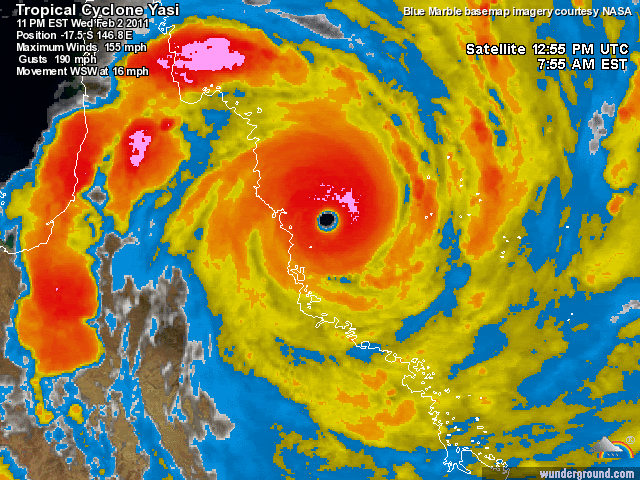
Ik vernam het nieuws ook net, grootste orkaan sinds een eeuw daar in Australië ...
Op zaterdag 28 juni 2014 @ 18:18 schreef Marie30 het volgende: Zo lief. :) Kusje :*
Op donderdag 14 juli 2016 @ 23:45 schreef GGMM het volgende: Het is altijd bijzonder gezellig als banaantje er is. :)
Op donderdag 14 juli 2016 @ 23:45 schreef GGMM het volgende: Het is altijd bijzonder gezellig als banaantje er is. :)

Ik vraag me af of die waardes wel werkelijk worden gehaald. Als je zo naar de windstoten kijkt...135km/h hebben we hier in Nederland ook al aantal keren gehad.quote:
Volgens de Saffir-Simpson schaal was het ook een categorie 5 cycloon. 135 kts = 250 km/ uur
en windstoten tot 305 km/uur. Dit zal een spoor van verwoesting achterlaten.
Townsville Airport (9 m) O9bft (stoten 135 km/h)
Toch niet echt dramatisch als je het zo bekijkt.
Ben benieuwd naar meerdere metingen, vooral langs de kust.
Doe mee met het voorspellen van het weer!
Weekvoorspelling | Week 3 (invullen tot 16-01 - 11:59)
Maandvoorspelling Januari (Gesloten)
Jaarvoorspelling 2025 / 2026
Weekvoorspelling | Week 3 (invullen tot 16-01 - 11:59)
Maandvoorspelling Januari (Gesloten)
Jaarvoorspelling 2025 / 2026

De gevevens blijven maar op 135km/u vast geroest zitten bij wetteronline, meldingen komen binnen van 260 en 230 km/uquote:
[..]
Ik vraag me af of die waardes wel werkelijk worden gehaald. Als je zo naar de windstoten kijkt...135km/h hebben we hier in Nederland ook al aantal keren gehad.
Townsville Airport (9 m) O9bft (stoten 135 km/h)
Toch niet echt dramatisch als je het zo bekijkt.
Ben benieuwd naar meerdere metingen, vooral langs de kust.
Weer of geen weer, altijd actueel www.onweer-online.nl

Zo ziet het er nog niet echt naar uit.quote:
Wederom een potentiele cycloon in de maak?
[ afbeelding ]
Zolang het geen low ofzo heeft zal het niets speciaals worden.
Het acht-uur journaal gaat alleen maar over Egypte...
[b]Op zaterdag 31 december 2011 16:16 schreef Socios het volgende:[/b] Kusje voor jou. :) :@ :*
Zo gaat het al twee dagen, wees blij dat we hier en op o-o erover schrijvenquote:
Het acht-uur journaal gaat alleen maar over Egypte...
Weer of geen weer, altijd actueel www.onweer-online.nl
Weatherunderground heeft net geupdate, daar is te zien dat de windstoten 305.7 km/u zijn en de wind 249.4 km/u
Weer of geen weer, altijd actueel www.onweer-online.nl
Hier is voor mij voldoende, nu gaan we verder met het andere nieuws. Je mag 130 km/h op de Afsluitdijk, yesssquote:
[..]
Zo gaat het al twee dagen, wees blij dat we hier en op o-o erover schrijven
ooh en Terneuzen is ontsnapt aan een chemieramp *drama*
[b]Op zaterdag 31 december 2011 16:16 schreef Socios het volgende:[/b] Kusje voor jou. :) :@ :*
RTL nieuws had het wel in zijn half 8 nieuws
[ Bericht 13% gewijzigd door #ANONIEM op 02-02-2011 20:15:52 ]
[ Bericht 13% gewijzigd door #ANONIEM op 02-02-2011 20:15:52 ]
Bewakers moeten meer bevoegdheden krijgen... Nog steeds niks over Yasi
[b]Op zaterdag 31 december 2011 16:16 schreef Socios het volgende:[/b] Kusje voor jou. :) :@ :*
Vanochtend ben ik gemaild door mijn vriendin uit Mount Garnet. Daar waar de cycloon dus keihard overheen is gegaan...:
Enge beelden ook op het 8-uur journaal en internet, zou doodsbang zijn. Gelukkig weet ik dat mijn vriendin een superbikkel is en ook verstandig genoeg om maatregelen te nemen.
Ze heeft een veeboerderij met haar man en dochtertje dus da's ook niet echt fijn vertrekken, maar ben blij dat ze weg is gegaan en hopelijk gewoon veilig zit.quote:Hai BBQ-kip,
Even een kort berichtje van down under.
Momenteel is er een cycloon onderweg naar het vaste land de ergste sinds mensenheugenis. Wij zullen hier ook erg door geraakt worden maar zijn goed voorbereid en veilig. We blijven niet thuis maar gaan naar een opvangplek die veilig is. Maak je dus maar geen zorgen en zodra ik weer kan e mailen geef ik weer een teken van leven en laat weten hoe het afgelopen is ik ga snel weer verder met de laatste voorbereidingen.
Veel liefs
Enge beelden ook op het 8-uur journaal en internet, zou doodsbang zijn. Gelukkig weet ik dat mijn vriendin een superbikkel is en ook verstandig genoeg om maatregelen te nemen.
Kip, het meest veelzijjjjjjjjjjjjjjjjjjjjjjjjjjjjjjjjjjjjjjjjjjjjjjjjjjjjjjjjjjjjjjjjjjjjdige stukje kaas, panda!
Ja, daar is ie! Op t NOS journaal dan
dusss, dat was t alweer
dusss, dat was t alweer
[b]Op zaterdag 31 december 2011 16:16 schreef Socios het volgende:[/b] Kusje voor jou. :) :@ :*
Kort nieuws inderdaad, bij rtl was het een stuk langer...quote:
Ja, daar is ie! Op t NOS journaal dan
dusss, dat was t alweer
@Aloa Je kan nu ook Yasi in je handtekening erbij zetten 
Weer of geen weer, altijd actueel www.onweer-online.nl

Genoeg youtube filmpjes te vinden inderdaad..quote:
@Aloa Je kan nu ook Yasi in je handtekening erbij zetten
Het is een cat 3 nu...
Dare to unleash my rage..
That's my secret Captain... I'm always angry...
There's nothing like a trail of blood, to find your way back home.
That's my secret Captain... I'm always angry...
There's nothing like a trail of blood, to find your way back home.
Hmm zit wel mooie beweging in:quote:
Wederom een potentiele cycloon in de maak?
[ afbeelding ]

Drugs are good mkay?

quote:Op woensdag 2 februari 2011 20:34 schreef Olga het volgende:
In een van de evacuatiecentra is een baby geboren
Die krijgt natuurlijk als naam iets van Hope, of Yasi

Wat lief! Nou ja, poetisch of zo, ik denk niet dat moeder helemaal kalm en rustig is... ±Dquote:
In een van de evacuatiecentra is een baby geboren
Lol, of Yassica voor een meisje en Yasper voor een jongen.quote:
[..]
Die krijgt natuurlijk als naam iets van Hope, of Yasi
be nice or go away
Tering hey, heb even het topic teruggelezen; wát een orkaan. Ben ook erg benieuwd hoe het nu met m'n oud-klasgenootje gaat. Geen idee of ze uiteindelijk nog vertrokken is uit Cairns, maar dat mag ik toch wel hopen na die berichten dat zelfs de "cycloon bestendige" gebouwen serieus gevaar lopen.
Charlie, listen to me. Kill the kid, torch the house, we gotta get out of here.
Yup... begint al wat rotatie in te komen, maar het is vrij kort voor de kust.quote:
[..]
Hmm zit wel mooie beweging in:
[ afbeelding ]
quote:NORTH Queensland residents are emerging from their shelters after a terrifying night being battered by the worst tropical storm in living memory.
There have been no reports of any deaths or serious injuries as a result of Cyclone Yasi, Premier Anna Bligh says.
She said Cairns had been spared the worst of the monster storm, with the smaller communities of Mission Beach, Tully, Tully Heads, and Cardwell bearing Yasi's full force.
"It does seem Cairns has been spared the worst and that's a great relief," she told the Nine Network.
"At this stage there are no reports of any serious injuries or fatalities and that's a great relief to me this morning."
The category five Yasi crossed the coast at Mission Beach around midnight (AEDT). It was early on Thursday morning downgraded to a category three and is still considered dangerous.
Gaat lekker in Australie.
Zojuist van www.abc.net.au:
Zojuist van www.abc.net.au:
quote:1 min ago
#TCYasi Townsville is still experiencing winds of up to 110kms. Please stay off the streets, and allow emergency services to do their job
En? is er al ernstige schade?
|| FOK!Stok || tatatatatataatatatattaaaaapiediedieuwtididipieuwpidibididi She said I'll throw myself away pididididum They're just photos after all! || Den Helder || Winnaar VBL Wijndal-award 2020: beste AZ-user! || Mijn concertstatistieken ||
Dat is inderdaad goed om te horen.quote:"It does seem Cairns has been spared the worst and that's a great relief," she told the Nine Network.
Charlie, listen to me. Kill the kid, torch the house, we gotta get out of here.
Vast wel. Maar 't is nog te vroeg om daar veel over te zeggen. Het is nog donker in Australie, en in de gebieden waar de cycloon is geweest waait het ook nog (te) hard.quote:
Het is hoogzomer en bijna zeven uur in de ochtend. Volgens mij is het dan inmiddels wel licht.quote:
Klopt, zon is inmiddels bijna een uur op. De eerste foto's zullen dus vrij snel online komen verwacht ik.quote:
[..]
Het is hoogzomer en bijna zeven uur in de ochtend. Volgens mij is het dan inmiddels wel licht.
Denk dat je gelijk hebtquote:
[..]
Het is hoogzomer en bijna zeven uur in de ochtend. Volgens mij is het dan inmiddels wel licht.
Verslag: http://www.nzherald.co.nz(...)10703822&ref=twitter
Enkele foto meest van voor de storm: http://www.nzherald.co.nz(...)ry_id=116525#7331009
hmm:
Enkele foto meest van voor de storm: http://www.nzherald.co.nz(...)ry_id=116525#7331009
hmm:
quote:Orkaan Yasi, een storm van de hoogste classificatie, heeft inmiddels de eerste schade aangericht in Australië. Vanuit het dorp Innisfail in het noordoosten van Queensland komen berichten dat er daken van huizen zijn gerukt.
be nice or go away
vrij vertaald door google:
Tully woont Stephanie Grimaz zei huizen in haar straat uit elkaar waren gescheurd.
"De flat van de overkant is in onze voortuin en kunnen we zien dat andere huizen die net zijn vernietigd," vertelde ze AAP.
"Er zijn overal platen van ijzer, de straten zijn gewoon vol puin."
Nieuws Limited fotograaf John Wilson genaamd ABC Radio vanuit een hotel in Tully.
De heer Wilson zei het gebouw is gebouwd naar categorie 5 orkanen te weerstaan, maar de muren stonden te schudden als de cycloon.
"Het klonk veel weg van een straalmotor - het was bijna ondraaglijk, het lawaai," zei hij.
"Je hoorde het geluid van de bomen worden versnipperd en af en toe snap."
Het oog van de cycloon ging rechtstreeks over de stad.
"Het ging absoluut rustige - de sterren scheen, was er een symfonie van kikkers crocking ... dan ongeveer 45 minuten later de maalstroom kwam terug," zei de heer Wilson.
Verwachtingen van de 'ramp zone'
Ingham burgemeester Pino Giandomenico verwacht daglicht te openbaren "enorme hoeveelheden van een bloedbad."
De heer Giandomenico, een veteraan van meerdere cyclonen, zei de wreedheid van de cycloon was beangstigend in Ingham, maar het was te vroeg om te zeggen wat schade aan de stad had geleden.
"Ik denk dat de hele tropische kust zal een ramp zone," vertelde hij AAP.
Hij zei later dat Yasi was een angstaanjagende ervaring.
"Ik heb meegemaakt ongeveer een half dozijn cyclonen en dit is het eerste dat wanneer het land raken, gewoon blijven pompen. Het niet uitgeschakeld weer helemaal niet," vertelde hij de Nine Network.
"De hele nacht was het als staande naast een 747 met de motoren brullen, en bomen knipperen en bashing, en dingen gaan hobbel in de nacht ...
"Het was een angstaanjagende nacht voor iemand die is door middel van een half dozijn cyclonen."
Op Innisfail, ongeveer 75 kilometer ten zuiden van Cairns, er zijn meldingen van daken gerukt van gebouwen, waaronder een lokale pub. De stad werd verwoest door Larry in 2006.
Doodsbang evacues verschansten zich in een noodopvang hebben verteld van de ramen te buigen onder de hevige wind en water overstromingen in onder deuren.
Correspondent Duncan vertelde Paterson AAP mensen waren gedwongen om krampachtig houten planken hamer op de onderkant van deuren naar het water stromende te stoppen in een opvangcentrum aan de Rising Sun gebouw, waar 70 mensen zich verschansen.
In Townsville, ABC News reporter Murray vertelde Cornish Radio Nieuw-Zeeland de timing van Yasi maken aanlanding had het geluk dat ontkend laagtij de effecten van stormvloeden.
"Zoals de stormvloed is omhoog te duwen de rivieren het tij is uit te gaan," zei hij.
De heer Cornish zei dat er al meerdere meldingen van schade als gevolg van de cycloon geweest en wist van een dak, dat had geblazen van een gebouw.
http://www.ustream.tv/channel/yasi-from-innisfail
lijkt wel zowat windstil
edit: onee, foutje, laat maar
[ Bericht 14% gewijzigd door Turbomuis op 02-02-2011 22:56:41 ]
lijkt wel zowat windstil
edit: onee, foutje, laat maar
[ Bericht 14% gewijzigd door Turbomuis op 02-02-2011 22:56:41 ]
I give myself very good advice
But I very seldom follow it
That explains the trouble that I'm always in
But I very seldom follow it
That explains the trouble that I'm always in

Door het drukverschil is er een grotere kans op geboortes. Waar ik woonde werden vrouwen die meer dan 7 maanden zwanger waren geacht zich preventief in het ziekenhuis te vervoegen. Dat deed alleen bijna niemand, want je moest zonder partner (was geen plaats voor), en kreeg alleen een stoel aangeboden.quote:
In een van de evacuatiecentra is een baby geboren
Een vriendin van me kreeg een paar dagen na typhoon Pongsona een prematuurtje, maar dat was van de stress: hun huis was ingestort terwijl ze erin zaten, en ze moesten midden in de typhoon een ander onderkomen zoeken (en woonden nogal afgelegen).
Trouwens:
quote:8.51am Good news comes in threes and for Queensland that means babies who couldn't wait to be born during Cyclone Yasi.
Premier Anna Bligh says two came into the world at Innisfail hospital right in the midst of the monster storm along with the little girl born in a Cairns evacuation centre this morning.
She's guessing they'll be some of the most sought-after baby photos globally.

Maar dit is ook vreselijk niet cycloon-proof gebouwd. Eigenlijk alles met golfplaten op het dak is gedoemd kapot te waaien. Ik snap dat niet zo goed: ik zou dit verwachten van allerhande pacific eilandjes, maar eigenlijk niet van Australie.
En nu is het een categorie 1...quote:
Het is nu een Tropische storm. (categorie 2 volgens de Australische schaal)
Dare to unleash my rage..
That's my secret Captain... I'm always angry...
There's nothing like a trail of blood, to find your way back home.
That's my secret Captain... I'm always angry...
There's nothing like a trail of blood, to find your way back home.
Te vergelijken met een windkracht 8 a 9 Beaufort. Nog hoog voor boven land.quote:
[..]
En nu is het een categorie 1...
Voor zover nog geen doden, dat is wel erg fijn nieuws.
I am unconditionally and irrevocably in love with him.
I'm 97% sure you don't like me, I'm 100% sure I don't care.
I'm 97% sure you don't like me, I'm 100% sure I don't care.
Zeg dat nog maar niet te snel.
Doe mee met het voorspellen van het weer!
Weekvoorspelling | Week 3 (invullen tot 16-01 - 11:59)
Maandvoorspelling Januari (Gesloten)
Jaarvoorspelling 2025 / 2026
Weekvoorspelling | Week 3 (invullen tot 16-01 - 11:59)
Maandvoorspelling Januari (Gesloten)
Jaarvoorspelling 2025 / 2026
