WKN Weer, Klimaat en Natuurrampen
Lees alles over het onstuimige weer op onze planeet, volg orkanen en tornado's, zie hoe vulkanen uitbarsten en hoe Moeder Aarde beeft bij een aardbeving. Alles over de verwoestende kracht van onze planeet en tal van andere natuurverschijnselen.


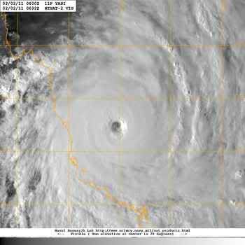
Volgens de Australische schaal is het nu een cat 5. Volgens de schaal van Saffir-Simpson is het nog net geen categorie 5.

quote:De gevolgen van de cycloon zullen gruwelijk zijn
De cycloon Yasi komt over een paar uur aan land en de gevolgen zullen rampzalig zijn, golven bereiken momenteel een hoogte van 12 meter en in combinatie met een stormvloed van 2 tot 4 meter zal dat leiden tot massale overstromingen. Een groot deel van het gebied zal naar verwachting worden getroffen door Yasi, laag gelegen krijgen te maken met ernstige overstromingen, enkele kustplaatsen zullen na verwachting verwoest worden. Yasi, een cycloon in de zwaarste categorie 5, wordt waarschijnlijk een van de grootste cycloon die Australië ooit getroffen heeft.
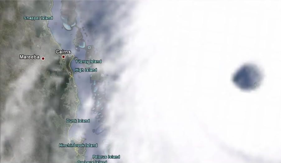
In de afgelopen paar uur is de wind fors in kracht toegenomen in Townsville. Yasi zal naar verwachting vanavond aan land komen ongeveer 50 à 100 kilometer ten noorden van Townsville. Overstromingen zullen ook in het binnenland voor gaan komen, de cycloon blijft intact voor meer dan 24 uur, dat is ongelooflijk zeldzaam. Zelfs orkanen in Amerika doen dit zelden. Cairns zal ook hard worden getroffen echter de de positie van de cycloon is verschoven naar het zuiden, mogelijk wordt de stad een catastrofe bespaart.
Hoofd weer analist Philip Duncan zei dat deze cycloon gebouwen zal gaan vernietigen, maar ook mensenlevens. "Er is geen twijfel over dat de monster cycloon een moordenaar is. Iedereen die in de buurt van het centrum van de cycloon zit zullen het waarschijnlijk niet overleven. Er worden windstoten verwacht tot zo'n 300 kilometer per uur, maar de stormvloed baart mij het meeste zorgen", aldus Philip Duncan.
Philip Duncan benadrukte ook dat de bevolking nog steeds de mogelijkheid heeft om naar een veilige plek te vertrekken. We zitten bijna op het punt dat de mensen de storm niet meer kunnen ontlopen.

Weer of geen weer, altijd actueel www.onweer-online.nl
Zie de openingspost van dit topicquote:Op dinsdag 1 februari 2011 22:13 schreef Disorder het volgende:
Is het normaal voor een cycloon om zo laat/vroeg nog geboren te worden? Of geldt het orkaan seizoen dus alleen voor orkanen?
Hurricane Season 2011
Kan je precies zien waar welk orkaanseizoen is. Australie zit nog wel even in de shit.. tot april met februari als piekmaand... Kunnen na Yasi zo nog maar meer orkanen volgen.
Vanmiddag bedoel jequote:
[..]
Morgen avond bordje eten op schoot en webcams F5'n
quote:30.000 geëvacueerd
De Australische deelstaat Queensland zet zich schrap voor de cycloon Yasi die naar verwachting vanmiddag, onze tijd de kust bereikt. De premier van Queensland, Anna Bligh, riep bewoners van laaggelegen kustgebieden op om een veilig heenkomen te zoeken.
"U heeft nog steeds de mogelijkheid om naar een veilige plek te vertrekken, ik kan niet genoeg benadrukken dat u van die mogelijkheid gebruik moet maken", aldus de premier. Yasi, een cycloon in de zwaarste categorie 5, wordt waarschijnlijk een van de grootste stormen die Australië ooit troffen. Onder andere de steden Cairns, Townsville en Mackay liggen in het pad van de storm.
Meer dan tienduizend mensen verblijven al in schuilplaatsen. Die zijn soms zo vol dat de politie mensen weer wegstuurt. Zo'n dertigduizend mensen hebben hun huis verlaten. Premier Bligh verwacht dat 200.000 mensen zonder stroom en telefoon komen te zitten door de storm.
Technici hebben gewaarschuwd dat zelfs de speciale stormbestendige woningen in de regio beschadigd kunnen raken door de storm, die windsnelheden bereikt tot 300 kilometer per uur. (anp/vsv)
Ik heb geen cijfers voor je, maar het overgrote deel van de Australische huizen zijn weatherboard of brick veneer. Hout dus.quote:
WTF, cat. 5. Gelukkig zijn de huizen in Australië niet van hout zoals dat wel zo is in Amerika.
Deze site heeft up-to-date nieuws en een rits links naar nog werkende webcams (zie post van 06:24):
http://www.abc.net.au/news/events/cyclone-yasi/
Het is al behoorlijk aan het spoken.
[ Bericht 6% gewijzigd door Rorsach op 02-02-2011 09:21:50 ]
http://www.abc.net.au/news/events/cyclone-yasi/
Het is al behoorlijk aan het spoken.
[ Bericht 6% gewijzigd door Rorsach op 02-02-2011 09:21:50 ]

Een rotsituatie inderdaad, vooral omdat je vanaf hier niets kunt doen. Ik maak me momenteel ongerust over een oud-klasgenootje, die amper een week geleden naar Cairns is gevlogen voor een internationale stage van een paar maanden en nu dus al flink in de penarie zit. Ze was volgens mij nog niet geëvacueerd, ik hoop dat dat snel nog gaat gebeuren, hoewel ze zelf schrijft dat de gebouwen daar, of in elk geval het hotel waarin ze verblijft, gebouwd zijn om een cycloon te kunnen weerstaan. Wat ze ook doet; ik hoop maar dat ze snel een berichtje op d'r blog plaatst dat alles goed gegaan is...quote:Op woensdag 2 februari 2011 01:13 schreef BBQ-kip het volgende:
Vriendin van me woont in Mount Garnet, 2,5 uur vanaf de kust en precies ook waar de cycloon zwaar overheen raast, het staat zo heel fijn rood omrand op één van de eerder getoonde kaartjes...
Ik hou de berichtgeving dus in de gaten en heb haar gevraagd om te mailen als het is geweest, als het internet het nog doet enzo... Bah bah... narigheid
http://maps.google.nl/map(...).756023,4.927368&z=8
Charlie, listen to me. Kill the kid, torch the house, we gotta get out of here.

Thx!quote:
Deze site heeft up-to-date nieuws en een rits links naar nog werkende webcams:
http://www.abc.net.au/news/events/cyclone-yasi/
Het is al behoorlijk aan het spoken.


quote:Australia Buro Of Meteorology says Willis Island observation station may have been destroyed. No data for over 40 minutes.
quote:Category five Cyclone Yasi has knocked out the weather bureau's radar system on Willis Island, about 450 kilometres east of Cairns in far north Queensland.
The weather bureau's radar and wind speed measurements on the island failed just before 9am (AEST).
The bureau says the maximum wind speed recorded before the equipment went down was 185 kilometres per hour.
Three weather observers and a technician left the island yesterday

30.000 Aussies hebben huis verlaten voor cycloon Yasi
Aussies wachten in sportzalen samen de komst af van cycloon Yasi. © epa
De Australische deelstaat Queensland zet zich schrap voor de cycloon Yasi die naar verwachting vanmiddag, onze tijd de kust bereikt. De premier van Queensland, Anna Bligh, riep bewoners van laaggelegen kustgebieden op om een veilig heenkomen te zoeken.
"U heeft nog steeds de mogelijkheid om naar een veilige plek te vertrekken, ik kan niet genoeg benadrukken dat u van die mogelijkheid gebruik moet maken", aldus de premier. Yasi, een cycloon in de zwaarste categorie 5, wordt waarschijnlijk een van de grootste stormen die Australië ooit troffen. Onder andere de steden Cairns, Townsville en Mackay liggen in het pad van de storm.
Meer dan tienduizend mensen verblijven al in schuilplaatsen. Die zijn soms zo vol dat de politie mensen weer wegstuurt. Zo'n dertigduizend mensen hebben hun huis verlaten. Premier Bligh verwacht dat 200.000 mensen zonder stroom en telefoon komen te zitten door de storm.
Technici hebben gewaarschuwd dat zelfs de speciale stormbestendige woningen in de regio beschadigd kunnen raken door de storm, die windsnelheden bereikt tot 300 kilometer per uur. (anp/vsv)


Water staat nu al hoog en het ergste moet nog komen. Stormvloed van meer dan 5.5 meter.quote:
Sommige mensen vragen ook wel om problemen.
En het oog is goed te zien op de radar:
http://www.bom.gov.au/products/IDR192.loop.shtml#skip
Webcam met wel heel lage FPS, maar wel geluid:
http://www.ustream.tv/channel/cyclone-yasi---cairns-beaches
Gaat heftig worden daar
http://www.bom.gov.au/products/IDR192.loop.shtml#skip
Webcam met wel heel lage FPS, maar wel geluid:
http://www.ustream.tv/channel/cyclone-yasi---cairns-beaches
Gaat heftig worden daar
Drugs are good mkay?
Oog is 35km groot en zal een uur kunnen duren voor ie voorbij getrokken is, mensen worden dus gewaarschuwd niet te denken dat het voorbij is als het kalmeert.

En dan zie je maar weer dat dit niks is vergeleken met Katrina qua omvang 
Doe mee met het voorspellen van het weer!
Weekvoorspelling | Week 3 (invullen tot 16-01 - 11:59)
Maandvoorspelling Januari (Gesloten)
Jaarvoorspelling 2025 / 2026
Weekvoorspelling | Week 3 (invullen tot 16-01 - 11:59)
Maandvoorspelling Januari (Gesloten)
Jaarvoorspelling 2025 / 2026
Qua omvang misschien niet, maar deze is krachtiger.quote:
En dan zie je maar weer dat dit niks is vergeleken met Katrina qua omvang
I am unconditionally and irrevocably in love with him.
I'm 97% sure you don't like me, I'm 100% sure I don't care.
I'm 97% sure you don't like me, I'm 100% sure I don't care.
Innisfail krijgt de volle laag en Georgetown, zon 275 kilometers landinwaarts krijgt nog cat.3 orkaankrachtquote:TOP PRIORITY
TROPICAL CYCLONE ADVICE NUMBER 20
Issued by the Bureau of Meteorology, Brisbane
Issued at 8:07pm EST on Wednesday the 2nd of February 2011
A Cyclone WARNING is current for coastal and island communities from Cape
Flattery to Sarina , extending west across the tropical interior to the Northern
Territory border.
At 8:00 pm EST Severe Tropical Cyclone Yasi, Category 5 was estimated to be 165
kilometres east southeast of Cairns and 135 kilometres east northeast of
Innisfail and moving west southwest at 26 kilometres per hour.
THE VERY DESTRUCTIVE CORE OF CYCLONE YASI WILL CROSS THE COAST NEAR INNISFAIL
CLOSE TO MIDNIGHT, WITH A DANGEROUS STORM TIDE AND BATTERING WAVES SOUTH OF THE
CYCLONE CENTRE.
Tropical Cyclone Yasi, CATEGORY 5, will continue to move in a west-southwesterly
direction and is expected to cross the coast near Innisfail close to midnight.
Coastal residents between Cairns and Ayr are specifically warned of an EXTREMELY
DANGEROUS SEA LEVEL RISE [i.e. storm tide] as the cyclone approaches, crosses
the coast and moves inland.
Higher than normal tides will exceed the high water mark with damaging waves and
flooding in low lying areas in remaining warning areas to the south of Ayr.
VERY DESTRUCTIVE winds with gusts up to 290 km/h are expected to develop between
Cairns and Ingham during the next few hours as the cyclone approaches. These
VERY DESTRUCTIVE winds will extend inland to the nearby ranges including the
Atherton Tablelands.
Due to the large size of the cyclone, people in the path of the VERY DESTRUCTIVE
WINDS are likely to experience these conditions for about 3 to 4 hours.
DESTRUCTIVE winds with gusts in excess of 125 km/h between Cape Tribulation and
Ayr are expected to spread inland overnight.
DAMAGING WINDS with gusts to 90 km/hr are occurring in remaining coastal areas
between Cape Flattery and Sarina, and are forecast to spread inland and west to
Mt Isa during Thursday.
Winds are forecast to gradually ease about the east coast during Thursday
morning as the cyclone moves inland.
FLOODING RAINS will develop from Cooktown to Sarina tonight and gradually extend
inland.
People in the path of the very dangerous cyclone should stay calm and remain in
a secure shelter, above the expected water level, while the very destructive
winds continue.
- Do not venture outside if you find yourself in the eye of the cyclone; very
destructive winds from a different direction could resume at any time.
- Follow the evacuation advice or directions of Police, Emergency Services
personnel and local authorities.
People in remaining areas between Cape Flattery and Sarina and extending west
across the tropical interior to the Northern Territory border, should complete
preparations quickly and be prepared to shelter in a safe place.
- Boats and outside property should be secured.
- For cyclone preparedness and safety advice, visit Queensland's Disaster
Management Services website [www.disaster.qld.gov.au]
- For emergency assistance call the Queensland State Emergency Service [SES] on
132 500 [for assistance with storm damage, rising flood water, fallen trees on
buildings or roof damage].
Details of Severe Tropical Cyclone Yasi at 8:00 pm EST:
.Centre located near...... 17.2 degrees South 147.3 degrees East
.Location accuracy........ within 20 kilometres
.Recent movement.......... towards the west southwest at 26 kilometres per hour
.Wind gusts near centre... 285 kilometres per hour
.Severity category........ 5
.Central pressure......... 930 hectoPascals
Please ensure that neighbours have heard and understood this message,
particularly new arrivals or those who may not fully understand English.
The next advice will be issued by 9:00 pm EST Wednesday 02 February.
This warning is also available through TV and Radio Broadcasts; the Bureau's
website at www.bom.gov.au or call 1300 659 212. The Bureau and the State
Emergency Service would appreciate this warning being broadcast regularly.
Hij is nu ongeveer aan land?
I am unconditionally and irrevocably in love with him.
I'm 97% sure you don't like me, I'm 100% sure I don't care.
I'm 97% sure you don't like me, I'm 100% sure I don't care.
WTF Komt de stormsurge ook nog samen met hoogtij?quote:MARK COLVIN: Cyclone Yasi is expected to set off storm surges around three metres above the normal high tide in Townsville from where our reporter Stephanie Smail joins us now.
Stephanie what will that mean?
STEPHANIE SMAIL: Mark, storm surges three metres above a high tide which is expected to reach four metres, means seven metres of water could be flowing through some suburbs of Townsville later tonight.
It's hoped that the high tide will peak and then go down before the cyclone crosses the coast but if that's not the case, then it's unknown what really could happen but up to 10,000 homes could be inundated according to local authorities.
check ff de rainfallquote:
En dan zie je maar weer dat dit niks is vergeleken met Katrina qua omvang
1000 mm predicted voor Yasi, net zoveel als Katrina
Echt je zou daar wonen. Je moet gewoon je huis uit met het idee dat als je terugkeert er helemaal niets meer is. Je huis weg, je spullen...
I am unconditionally and irrevocably in love with him.
I'm 97% sure you don't like me, I'm 100% sure I don't care.
I'm 97% sure you don't like me, I'm 100% sure I don't care.
quote:Bligh: #tcyasi warns about storm surge; the high tide in half hour's time, will add to storm surge. There will also be high tide 9.30am
Zo klote dat ik nu geen geluid heb om dat ABC te volgen
Als de complete orkaan nu boven West Europa zou liggen, ziet dat er zo uit
Als de complete orkaan nu boven West Europa zou liggen, ziet dat er zo uit

WTF hee, dat geeft wel aan hoe groot dat ding toch is!
En 1000 mm regenval is echt sick.
En 1000 mm regenval is echt sick.
's Avonds een man, overdags rustig an
Dat is mooi dacht ikquote:
Livestream: Townsville/queensland
http://www.ustream.tv/channel/caillins13
Aii dat kan nog eens lastig wordenquote:
Doe mee met het voorspellen van het weer!
Weekvoorspelling | Week 3 (invullen tot 16-01 - 11:59)
Maandvoorspelling Januari (Gesloten)
Jaarvoorspelling 2025 / 2026
Weekvoorspelling | Week 3 (invullen tot 16-01 - 11:59)
Maandvoorspelling Januari (Gesloten)
Jaarvoorspelling 2025 / 2026
http://www.ssd.noaa.gov/mtsat/flt/t1/flash-avn.htmlquote:Latest satellite loop seems to show Yasi strengthening. Deepest convection starting to wrap mst of way around eye
Wordt ie nou nog sterker?
Maar waar is West-Europa dan?quote:
Zo klote dat ik nu geen geluid heb om dat ABC te volgen
Als de complete orkaan nu boven West Europa zou liggen, ziet dat er zo uit
[ afbeelding ]
@SpeedyGJ
wel wat voor jou, deze weerdata uit Cairns
check die temperatuurs- en drukverschillen in de afgelopen 24 uur
http://cairnsweathercam.com.au/weather-display-live.php
wel wat voor jou, deze weerdata uit Cairns
check die temperatuurs- en drukverschillen in de afgelopen 24 uur
http://cairnsweathercam.com.au/weather-display-live.php
Die temperatuurdaling van 6 graden, is dat overdag? En de luchtdruk is ook behoorlijk gedaald idd... ruim 20 hPa in 24 uur. Er staat ook een leuk briesjequote:
@SpeedyGJ
wel wat voor jou, deze weerdata uit Cairns
check die temperatuurs- en drukverschillen in de afgelopen 24 uur
http://cairnsweathercam.com.au/weather-display-live.php
Ik zie NL/Belg liggen....ik praat altijd zo leuk maar als je dit dan op je af ziet komen in het echtquote:
Zo klote dat ik nu geen geluid heb om dat ABC te volgen
Als de complete orkaan nu boven West Europa zou liggen, ziet dat er zo uit
[ afbeelding ]
Even goed kijken, je ziet NL in het blauwe gedeelte zitten ten westen van het oog.quote:
Het lijkt er wel op...quote:
[..]
http://www.ssd.noaa.gov/mtsat/flt/t1/flash-avn.html
Wordt ie nou nog sterker?
Dank je zal eens gaan kijkenquote:
@SpeedyGJ
wel wat voor jou, deze weerdata uit Cairns
check die temperatuurs- en drukverschillen in de afgelopen 24 uur
http://cairnsweathercam.com.au/weather-display-live.php
Nog ammateurmetingen?
Doe mee met het voorspellen van het weer!
Weekvoorspelling | Week 3 (invullen tot 16-01 - 11:59)
Maandvoorspelling Januari (Gesloten)
Jaarvoorspelling 2025 / 2026
Weekvoorspelling | Week 3 (invullen tot 16-01 - 11:59)
Maandvoorspelling Januari (Gesloten)
Jaarvoorspelling 2025 / 2026
Ten westen van het oog is wel veel blauw, maar da's oceaanquote:
Even goed kijken, je ziet NL in het blauwe gedeelte zitten ten westen van het oog.
Oeps ik bedoel ten oostenquote:
[..]
Ten westen van het oog is wel veel blauw, maar da's oceaan
Doe mee met het voorspellen van het weer!
Weekvoorspelling | Week 3 (invullen tot 16-01 - 11:59)
Maandvoorspelling Januari (Gesloten)
Jaarvoorspelling 2025 / 2026
Weekvoorspelling | Week 3 (invullen tot 16-01 - 11:59)
Maandvoorspelling Januari (Gesloten)
Jaarvoorspelling 2025 / 2026
Op Twitter komen eerste berichten over schade
-Stroom uitgevallen op Magnetic eiland voor de kust
-flikkerende lichten in Cairns
en dingen als
http://www.google.nl/imag(...)=wi&biw=1024&bih=583
-Stroom uitgevallen op Magnetic eiland voor de kust
-flikkerende lichten in Cairns
en dingen als
Net ff gegoogled... mag niet hopen dat zelfs dat soort gebouwen nu al kapot gaanquote:Reports of roof starting to lift off the Urban Quarter building in Townsvill
http://www.google.nl/imag(...)=wi&biw=1024&bih=583
Een vriendin van me zou vandaag vanuit Cairns terugvliegen naar NL, maar is geevacueerd naar een winkelcentrum. Zal er eens smsen hoe het ervoor staat nu.
Hallo NOSquote:Eerste schade orkaan in Australië
De orkaan Yasi heeft de eerste schade aangericht in Australië. Vanuit het dorp Innisfail in het noorden van Queensland komen berichten dat er daken van huizen zijn gerukt en bomen zijn omgewaaid.
Het oog van de orkaan wordt verwacht in de loop van de middag (Nederlandse tijd), als het in Australië nacht is. Het advies aan bewoners is om binnen te blijven, omdat het te gevaarlijk is om nog te vluchten.
Yasi wordt waarschijnlijk een van de zwaarste stormen in de geschiedenis van Australië. Er worden windsnelheden van 300 km/u verwacht. Tienduizenden mensen zijn hun huis ontvlucht.


Weet niet of deze foto 'echt' is... maar...

quote:Wednesday: Cyclone Yasi is the strongest threat ever remembered to Australia, It is at the speed of 555km east of Cairns and 560km northeast of Townsville. It has winds of up to 295 km/h at its centre.
Massive destruction and deaths can happen, its just the matter of time that we can actually see the giant Cyclone on land.
It is a category five storm and is expected to be the largest to ever hit the continent.
Officials have urged the residents to Immediately evacuate before the mighty Cyclone hits Queensland.Many residents of the area had to take shelter last March when a Category 3 Tropical Cyclone Ului barreled in. But that storm has no comparison to the strength that Cyclone Yasi bags.
Ze zit nu 14u in de shopping mall, stroom viel net ff uit, maar verder merkt ze er nog weinig van zegt ze.
http://www.ustream.tv/cha(...)68&utm_medium=social
http://werdjs.blogspot.com/2011/02/cyclone-yasi.html
http://werdjs.blogspot.com/2011/02/cyclone-yasi.html
I am unconditionally and irrevocably in love with him.
I'm 97% sure you don't like me, I'm 100% sure I don't care.
I'm 97% sure you don't like me, I'm 100% sure I don't care.
Wel lekker zoveel wind bij temperaturen tussen 25°C en 30°Cquote:
@SpeedyGJ
wel wat voor jou, deze weerdata uit Cairns
check die temperatuurs- en drukverschillen in de afgelopen 24 uur
http://cairnsweathercam.com.au/weather-display-live.php
Nog een klein uur dacht ik dan komt het oog aan landquote:
Ze zit nu 14u in de shopping mall, stroom viel net ff uit, maar verder merkt ze er nog weinig van zegt ze.
Sterkte

Haha, wat heeft die foto met een cycloon te maken?quote:
Weet niet of deze foto 'echt' is... maar...
[ afbeelding ]
[..]
's Avonds een man, overdags rustig an

Zieke shit, ik blijf ff kijken.
A man said to the universe: 'Sir, I exist.'
'However', replied the universe. 'This fact has not created in me a sense of obligation.'
'However', replied the universe. 'This fact has not created in me a sense of obligation.'
Ik weet niet wat dat voor stormcomplex is voor dat bootje, maar ik zou er niet heel vrolijk van worden.quote:
[..]
Haha, wat heeft die foto met een cycloon te maken?
Duurt nog wel een paar uur.quote:
[..]
Nog een klein uur dacht ik dan komt het oog aan land
Sterkte

Gruwelijk 
|| FOK!Stok || tatatatatataatatatattaaaaapiediedieuwtididipieuwpidibididi She said I'll throw myself away pididididum They're just photos after all! || Den Helder || Winnaar VBL Wijndal-award 2020: beste AZ-user! || Mijn concertstatistieken ||

Hoe laat komt ie aan land? NL tijd..
|| FOK!Stok || tatatatatataatatatattaaaaapiediedieuwtididipieuwpidibididi She said I'll throw myself away pididididum They're just photos after all! || Den Helder || Winnaar VBL Wijndal-award 2020: beste AZ-user! || Mijn concertstatistieken ||
Dr wordt gezegd dat dat een foto vanaf een tanker is, met uitzicht op Yasiquote:
[..]
Haha, wat heeft die foto met een cycloon te maken?
maar onbevestigd, lijkt me namelijk een 'simpele' onweerswolk. Maar goed, geen idee
Tussen 1500-1600 uur denk ikquote:Op woensdag 2 februari 2011 13:31 schreef Dagoduck het volgende:
Hoe laat komt ie aan land? NL tijd..
townsville: http://www.ustream.tv/channel/cyclone-yasi-townsville
Cairns: http://www.ustream.tv/channel/cyclone-yasi-cairns-cbd
Cairns: http://www.ustream.tv/channel/cyclone-yasi-cairns-cbd
I am unconditionally and irrevocably in love with him.
I'm 97% sure you don't like me, I'm 100% sure I don't care.
I'm 97% sure you don't like me, I'm 100% sure I don't care.
quote:Queensland Premier Anna Bligh says 89,000 houses are currently without power
quote:Bligh: Reports of 18m wave in Townsville not accurate
quote:Waves of 9.5 metres reported off Townsville as Cyclone Yasi approaches
Stormchaserreports via Twitter
quote:The winds are roaring like a freight train here. Unbelievable. We're bunkered down. #TCYasi
quote:These winds are forecast to get stronger as the peak is still two hours away. #TCYasi
quote:Eyewall is 50km away at 70 degrees from our position
Die twitterberichten zijn ook wel bizar, 1 op 1 getuigenissen enzo...quote:
townsville: http://www.ustream.tv/channel/cyclone-yasi-townsville
Cairns: http://www.ustream.tv/channel/cyclone-yasi-cairns-cbd
quote:ABCnorthqld | 2 mins ago
Rain seems to have changed direction in Airlie Beach - now hitting the side windows. Anyone else notice a change ? #TCYasi
I give myself very good advice
But I very seldom follow it
That explains the trouble that I'm always in
But I very seldom follow it
That explains the trouble that I'm always in
1:51 Traiteri: outside probably CAT 1 or 2, inside nice and safe and dry, no problems
Uit de chats bij de webcam..
Uit de chats bij de webcam..
I am unconditionally and irrevocably in love with him.
I'm 97% sure you don't like me, I'm 100% sure I don't care.
I'm 97% sure you don't like me, I'm 100% sure I don't care.

Wij zitten een radio ABC far North Queensland te luisteren, die zitten in Cairns en zagen net een krokodil van over twee meter voorbij komen...
De cycloon en water zijn 1 probleem, een volgend probleem is dat na de storm er ineens krokodillen op de meest vreemde plekken opduiken. En North Queensland heeft een enorme populatie krokodillen.
http://www.abc.net.au/farnorth/
Die geven nu continu live reports van de mensen in Cairns.
De cycloon en water zijn 1 probleem, een volgend probleem is dat na de storm er ineens krokodillen op de meest vreemde plekken opduiken. En North Queensland heeft een enorme populatie krokodillen.
http://www.abc.net.au/farnorth/
Die geven nu continu live reports van de mensen in Cairns.
Record brekende golf bij Townsville
Afgelopen nacht heeft wederom een golf het hoogterecord verbroken bij Townsville, terwijl uren daarvoor het record al eerder gesneuveld was. Op woensdagmorgen is een golf van 6.6 meter hoog bij de kust van Townsville waargenomen. Dit was toen de hoogste golf, die sinds het aanleggen van het hoogte-register begin jaren '70, werd waargenomen. Slechts enkele uren hierna werd het prille record verpulverd door een golf met een gigantische hoogte van 9.5 meter. De verwachting is, dat de golven zullen blijven groeien gedurende de komende uren. Echter lijkt de cycloon iets in treksnelheid te hebben afgenomen, wat gunstig is voor het gebied bij Townsville. Het getijde is nu landafwaarts en de cycloon zal bij laagtij aan land komen, waardoor het effect van een vloedgolf wordt verminderd. Echter een lagere snelheid betekent ook meer hevige neerslag en zal het gebied langer door hurricane winden worden getroffen, wat weer meer kans geeft op catastrofale schade.
De cycloon blijft een krachtige categorie 5 cycloon met windstoten oplopend tot 285km/h. WeatherWatch.co.nz schat in, dat de cycloon nu zich zo'n 80 kilometer van de kustlijn bevindt en meer dan 2000 kilometer breed is. In het afgelopen uur hebben windstoten Townsville getroffen met een snelheid van 104km/h. Op het moment van schrijven heeft de storm Cairns nog niet bereikt.
©onweer-online
Weer of geen weer, altijd actueel www.onweer-online.nl
Jammer dat Egypte alle aandacht van de FP krijgt...dit kan een catastrofe worden, wordt mijns inziens te weinig op gereageerd. Maar ja, bekend verhaal inmiddels
Ik weet niet of deze site al eens voorbij is gekomen: http://www.theaustralian.(...)7il3q4-1225998711771
Hier komen iig steeds updates binnen. Pff.. wat een storm zeg.
Hier komen iig steeds updates binnen. Pff.. wat een storm zeg.
be nice or go away
