WKN Weer, Klimaat en Natuurrampen
Lees alles over het onstuimige weer op onze planeet, volg orkanen en tornado's, zie hoe vulkanen uitbarsten en hoe Moeder Aarde beeft bij een aardbeving. Alles over de verwoestende kracht van onze planeet en tal van andere natuurverschijnselen.


Tienduizenden inwoners worden geevacueerd, patienten van ziekenhuizen worden naar andere ziekenhuizen gebracht. Deze cycloon gaat gevolgen hebben voor een groot gebied. Net voor landfall zal de cycloon windsnelheden behalen rond de 231 km/uur met windstoten die de 277 km/uur halen (categorie 4).
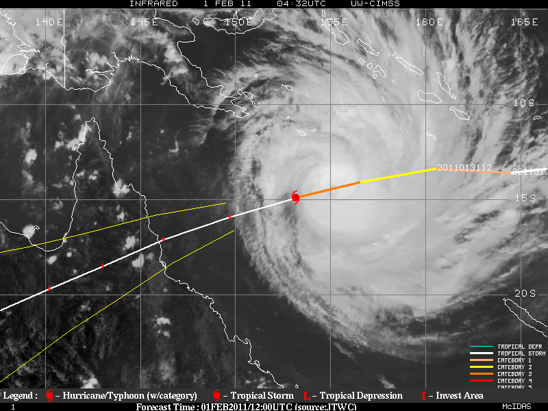
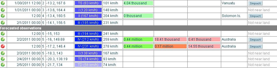
Het is nu een categorie 3 met een windsnelheid rond de 185 km/uur en windstoten tot 231 km/uur.
[ Bericht 0% gewijzigd door #ANONIEM op 01-02-2011 10:41:44 ]
Het is nu een categorie 3 met een windsnelheid rond de 185 km/uur en windstoten tot 231 km/uur.
quote:A cyclone described as a "monster, killer storm" is bearing down on Cairns, with communities far to the north, south and west of the northern Queensland tourist centre also braced for its fury.
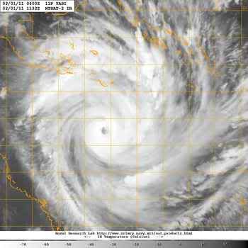
The latest modelling suggests Cyclone Yasi is on track to hit Cairns about 1am (AEST) on Thursday as a highly destructive category four storm with winds above 250km/h.
The Australian Defence Force has been called in to evacuate hundreds of patients from two Cairns hospitals.
And residents in low-lying areas have been told to abandon their homes with a storm surge of up to two metres expected in parts of Cairns, including the CBD.
Premier Anna Bligh says Yasi is so powerful that communities hundreds of kilometres away from where it crosses the coast will experience category one and two-type conditions.
"It's such a big storm, it's a monster killer storm, that it's not just about where this crosses the coast that is at risk," Ms Bligh said on Tuesday.
The volatile nature of cyclones means there's no guarantee Cairns will be ground zero. So far it's the Bureau of Meteorology's best guess, and it's where the most serious preparations are being made.
Communities as far north as Cooktown and as far south as Townsville have also been warned Yasi could hit them.
BOM senior forecaster Ann Farrell told AAP Yasi was continuing to intensify and she could not rule out the chance of it reaching category five.
"It is possible it could reach category five intensity, and that would push winds up to around the 300km/h mark," Ms Farrell said.
Yasi, which on Tuesday afternoon was a category three, is expected to take some time to die out after crossing the coast, with a firm monsoon pattern expected to continue feeding it once it's over land.
Bureau senior forecaster Gordon Banks warned cyclonic conditions may be seen far inland, possibly as far west as Mt Isa near the Northern Territory border.
"Certainly for north Queensland, we need to prepare for the eventuality of something really significant heading into areas that may not have seen this before," he told AAP.
Yasi is expected to be Queensland's worst cyclone, covering something approaching twice the physical size of Cyclone Larry, which devastated Innisfail in 2006 and left a $1.5 billion damage bill.
With such a large, powerful system in play, much of the north Queensland coast is preparing for dangerous storm surges.
Residents as far away as Townsville, Ingham and the Whitsunday resort islands are evacuating properties on the back of warnings from authorities.
Ms Bligh said mandatory evacuation orders were being given in council areas from Cook to Hinchinbrook for people in flood-risk areas.
In Cairns alone, about 9000 people will be evacuated, mostly to family and friends but six evacuation centres have been set up in and around the city to accommodate people who have nowhere to go.
[ Bericht 0% gewijzigd door #ANONIEM op 01-02-2011 10:41:44 ]


quote:Hoe groot is cycloon Yasi?
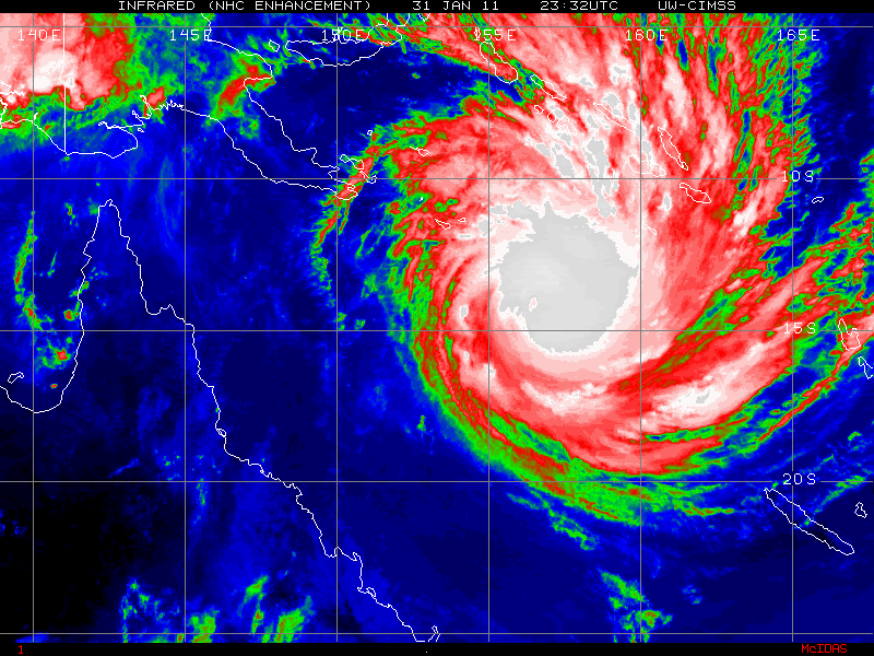
Dit beeld laat zien hoe enorm breed cycloon Yasi is. Er is een screenshot een gemaakt die ongeveer 1500 km aan kustlijn van Queensland laat zien, dat is net zo groot al geheel Nieuw-Zeeland Nieuw-Zeeland. Het beeld toont Cairns (uiterst links) en Brisbane (uiterst rechts). De cycloon zal naar verwachting net ten zuiden van Cairns aan land komen (uiterst links).

Weer of geen weer, altijd actueel www.onweer-online.nl

Omg  ik hou van orkanen maar dit gaat wel boven mijn pet
Doe mee met het voorspellen van het weer!
Weekvoorspelling | Week 45 (invullen tot 3-11 11:59)
Maandvoorspelling November (Gesloten)
Jaarvoorspelling 2024 / 2025
Weekvoorspelling | Week 45 (invullen tot 3-11 11:59)
Maandvoorspelling November (Gesloten)
Jaarvoorspelling 2024 / 2025
Webcamsite van Cairns
Mogelijk vanavond (onze tijd) nog wat leuke plaatjes, dan zullen ze wel op zwart gaan
http://www.cairnsinfo.com/webcam.php
Mogelijk vanavond (onze tijd) nog wat leuke plaatjes, dan zullen ze wel op zwart gaan
http://www.cairnsinfo.com/webcam.php

quote:Yasi will be worse then Larry
Cyclone Yasi will hit the north Queensland coast with greater ferocity than devastating Cyclone Larry, according to Premier Anna Bligh.
Thousands of residents, as well as patients at Cairns hospital, face the prospect of evacuations today as the huge storm front bears down.
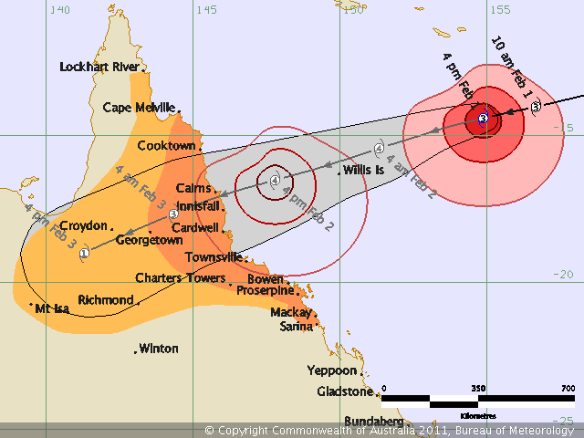
Latest modelling indicates the cyclone has moved slightly north and is now due to cross the coast between Tully and Lucinda, about 140 kilometres north of Townsville.
Ms Bligh, speaking after a meeting of the state disaster management group this morning, said winds of more than 250kmh could be expected from the high category four system.
By comparison Larry, which caused $1.5 billion worth of damage to Innisfail and surrounds in 2006, was a mid-level category four system.
"This of course is not only a system now tracking as more intense than Cyclone Larry, it is significantly larger than Cyclone Larry," Ms Bligh told reporters.
She said that meant areas to the north and the south of the crossing point would see effects including a high storm surge, torrential rain and destructive winds.
Low-lying areas at risk
Ms Bligh said everything possible was being done to prepare, including evacuations of low-lying areas at risk of tidal surges, and discussions with the defence force about what help they might provide.
She said gale force winds could be felt along the north Queensland coast from as early as 8am tomorrow, and warned residents in the danger zone they had a narrow window to prepare.
The size of Yasi meant many communities either side of where it made landfall could expect to see the impacts of "serious storm surges, flooding torrential rain and gale force winds", Ms Bligh said.
Ms Bligh said people must take the opportunity today to stock up on food and other supplies, with a real risk many could be without power for three to five days.
"I think many people will be very frightened by what they're hearing," she said.

Jemig wat is dat ding groot!
[b]Op maandag 6 september 2010 00:28 schreef tong80 het volgende:[/b]
GVD Wat moet jij een trotse vader zijn :)
:P
GVD Wat moet jij een trotse vader zijn :)
:P

Mooi filmpje. Je ziet Bianca, Anthony en Yasiquote:Op dinsdag 1 februari 2011 12:18 schreef Frutsel het volgende:
waanzinnig om te zien hoe dat ding zich heeft ontwikkeld
Australische kuststad maakt zich op voor cycloon
(Novum/AP) - Meer dan negenduizend bewoners van de stad Cairns aan de kust van de Australische staat Queensland moeten hun huizen verlaten in verband met een 'levensbedreigende' cycloon. Dinsdag werd een ziekenhuis door het leger geëvacueerd.
De cycloon, Yasi genaamd, zal Cairns waarschijnlijk woensdagavond bereiken. Verwacht wordt dat de storm de zeespiegel twee meter zal doen stijgen en dat de stad gedeeltelijk onder water zal komen te staan. De storm bereikt snelheden van 250 kilometer per uur en gaat gepaard met zware regenval.
Cairns heeft 164 duizend inwoners. Veel mensen maakten zich dinsdag uit eigen beweging al op om te vertrekken. Omdat het vliegveld van Cairns woensdag uit voorzorg dicht gaat, regelden luchtvaartmaatschappijen voor dinsdagavond extra vluchten. Toeristen braken hun vakantie af en vlogen naar huis.
Een andere cycloon, Anthony, trof Queensland maandagmorgen, maar richtte weinig schade aan.
Yasi zal Brisbane en andere steden in Queensland die sinds november zijn getroffen door zware overstromingen niet bereiken.
Nieuws.nl
Mogelijk dat Yasi even een cat 5 cycloon wordt:
http://www.abc.net.au/lateline/content/2011/s3127339.htm
http://www.abc.net.au/lateline/content/2011/s3127339.htm
Weer of geen weer, altijd actueel www.onweer-online.nl
Zou best eens kunnen. Ze voorspellen nu 240 km/uur en windstoten tot 296 km/uur.quote:
Mogelijk dat Yasi even een cat 5 cycloon wordt:
http://www.abc.net.au/lateline/content/2011/s3127339.htm
Categorie 5 is vanaf 250 km/uur.
quote:24 HRS, VALID AT:
021200Z --- 17.1S 146.2E
MAX SUSTAINED WINDS - 130 KT, GUSTS 160 KT
WIND RADII VALID OVER OPEN WATER ONLY
[ Bericht 15% gewijzigd door #ANONIEM op 01-02-2011 15:23:38 ]
Ruimte zat in Australie zou je denkenquote:
Ik las Marrokaan.
Anyway, waar moeten al die mensen heen om zich te beschermen dan?
[b]Op maandag 6 september 2010 00:28 schreef tong80 het volgende:[/b]
GVD Wat moet jij een trotse vader zijn :)
:P
GVD Wat moet jij een trotse vader zijn :)
:P