WKN Weer, Klimaat en Natuurrampen
Lees alles over het onstuimige weer op onze planeet, volg orkanen en tornado's, zie hoe vulkanen uitbarsten en hoe Moeder Aarde beeft bij een aardbeving. Alles over de verwoestende kracht van onze planeet en tal van andere natuurverschijnselen.


]

Welkom! Hier alweer het volgende deel in de reeks Hurricane Season! Alle informatie over het ontstaan van nieuwe orkanen in 2010 vind je hier. En natuurlijk volgen we ze allemaal op de voet! Voor zowel Atlantische, Indische als Pacifische stormen kan je hier terecht
Algemene Info
Met de term 'Hurricane Season' bedoelden we in eerste instantie de periode van 1 juni tot 30 november. Deze periode wordt in de Atlantische Oceaan en de Golf van Mexico gezien als het orkaanseizoen. Echter komen deze gewelddadige stormen overal in de wereld voor en met name in Azië zorgen ze jaarlijks voor duizenden slachtoffers en tienduizenden daklozen. Echter horen we vaak erg weinig over de stormen in Azië en juist meer over die in de VS.
In de laatste jaren zijn Tropische Stormen meer en meer in de media gekomen. Het lijkt ook alsof ze meer en meer slachtoffers maken. Een documentaire over Hurricane Andrew uit 1992, heeft diepe indruk gemaakt en ook zullen kenners orkanen Floyd, Gilbert, Stan en Ivan zich zeker nog herinneren. De catastrofe die "Katrina" met zich meebracht ging de hele wereld over. En dan praten we eigenlijk alleen over de Atlantische stormen en lijken we te vergeten dat er in 2007 meer dan 4000 doden vielen in Bangladesh door orkaan Sidr en orkaan Nargis zorgde voor 80.000 doden in Myanmar alleen al.
Hoewel het Atlantische seizoen pas officieel in juni begint zijn er op andere plekken in de wereld zeker meer orkanen te vinden in de komende maanden. We zullen ook deze dus zeker gaan bespreken. Waarschijnlijk zal de kern van de discussie en de posts gaan over de periode 1 juni tot 30 november. T.z.t. zal er ook wel een NWS-topic worden geopend als een orkaan ook uitgebreid in het nieuws komt.
Orkanen: Hoe ontstaan ze eigenlijk?
Op de site van Wikipedia kan je in het Nederlands nalezen hoe ze ontstaan en wat de belangrijkste energiebron is voor hun verwoestende kracht: het warme zeewater

Ook de BBC heeft er een interessante en leuke animatie over gemaakt.
Ook wordt er op LiveScience in het engels prima uitgelegd hoe ze ontstaan en zich ontwikkelen
Indeling, Kracht en Stormvloed
De stormen worden ingedeeld op 'categorie'. Vaak zijn het eerst tropische stormen" (Tropical Depression, Tropical Storms), die overgaan tot Orkaanstatus (Hurricanes/Tyfoons) Ze worden ingedeeld op windsnelheden via de Saffir-Simpson Schaal.
Door de enorme windkracht van een orkaan wordt het zeewater opgestuwd. Dit zeewater wordt als het ware vooruit geblazen, voor de storm uit. Hoe zwaarder de orkaan des te meer zeewater vooruit wordt geduwd. De stormvloed wordt dan ook gemeten bovenop de reguliere golfslag. Je kan het enigszins vergelijken met een muur van water (tsunami) die vooruit wordt geduwd.
Tropische Depressie: windsnelheden van 38 tot 61 km/u
Tropische Storm: windsnelheden van 62 tot 118 km/u
Orkaan 1e categorie: windsnelheden van 119 tot 153 km/u en een stormvloed van 1 tot 1,5 meter boven normaal
Orkaan 2e categorie: windsnelheden van 154 tot 177 km/u en een stormvloed van 1,5 tot 2,5 meter boven normaal
Orkaan 3e categorie: windsnelhden van 178 tot 209 km/u en een stormvloed van 2,5 tot 3,7 meter boven normaal
Orkaan 4e categorie: windsnelheden van 210-249 km/u en een stormvloed van 3,8 tot 5,5 meter boven normaal
Orkaan 5e categorie: windsnelheden > 250 km/u en een stormvloed van meer dan 5,5 meter boven normaal
TIP: Interactief (film)overzicht van de krachten van orkanen n.a.v. de schaal van Simpson
Waarom hebben orkanen namen?
De Tropische Depressies worden overal ter wereld in de gaten gehouden en zodra de depressies uitgroeien tot orkaan of cycloon, wordt er een naam aan de storm gegeven. Sinds 1950 krijgen ze namen op alfabetische volgorde (met uitzondering van de letters Q, U, X, Y en Z). Mocht een orkaan vernietigend hebben huisgehouden zoals Floyd, Gilbert en bijv. Katrina, dan zal die naam worden vervangen. Soms komt het ook voor dat alle letters van het alfabet gebruikt zijn in één seizoen (zoals 2005), dan zal een volgende storm Alpha gaan heten, gevolgd door Beta etc etc. Voor het orkanenseizoen 2010 zijn de namen als volgt:
Atlantische Stormen 2010
Alex, Bonnie, Colin, Danielle, Earl, Fiona, Gaston, Hermine, Igor, Julia, Karl, Lisa, Matthew, Nicole, Otto, Paula, Richard, Shary, Tomas, Virginie, Walter.
In het Noordoosten van de Pacific ontstaan ook orkanen. Deze zorgen meestal voor weinig schade aan de Amerikaanse/Mexicaanse westkust.
Oost Pacifische Stormen 2010
Agatha, Blas, Celia, Darby, Estelle, Frank, Georgette, Howard, Isis, Javier, Kay, Lester, Madeline, Newton, Orlene, Paine, Roslyn, Seymour, Tina, Virgil, Winifred, Xavier, Yolanda, Zeke
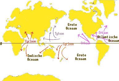
Verder zijn er dan nog de stormen in het Noorden, Zuiden en Westen van de Pacific. Daar worden ze tyfoons en/of cyclonen genoemd. Vooral de stormen in het Noord/Westen komen vaak in het nieuws omdat ze Japan, de Filippijnen, Taiwan en China vaak teisteren, maar ook geheel Zuid Oost Azië kunnen treffen. Meer informatie over de namen van orkanen vind je hier.
Leuk hoor allemaal, maar wanneer zijn die orkaanseizoenen nou precies?
ATLANTISCHE OCEAAN: 1 juni t/m 30 november
NOORD OOST PACIFIC:Begin mei t/m begin november, met piek in augustus/september
NOORD WEST PACIFIC: Begin juli t/m eind november, maar eigenlijk hele jaar door activiteit.
NOORD INDISCHE OCEAAN: april t/m december met pieken in mei en november
ZUID INDISCHE + WEST AUSTRALISCHE OCEAAN: oktober t/m mei met pieken in februari en april
ZUID WEST PACIFIC + OOST AUSTRALISCHE OCEAAN: oktober tot eind april met piek in februari.
Over het algemeen is Mei de rustigste maand en September de zwaarste.
En? Zijn er al verwachtingen en/of voorspellingen voor 2010?
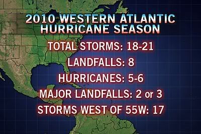
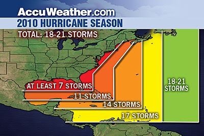
Begin december kwamen de eerste voorspellingen voor 2010 naar buiten. Ze verwachten een boven gemiddeld seizoen. 50 jaar orkaangeschiedenis heeft een zogenaamd gemiddeld orkaanseizoen gecreëerd. 9,6 stormen met naam, 5,9 groeit uit tot orkaan en 2,3 worden superorkanen (cat 4 of 5) Volgens de decemberverwachting is de verwachting dat er in 2010 elf tot zestien ‘naam-stormen’ zullen ontstaan in de Atlantische Oceaan. Zes tot acht groeien uit tot orkaan en drie tot vijf daarvan zullen superorkanen worden. Deze voorspelling kan je hier of hier nog eens nalezen.
Oude Delen
2004 - Deel 1 en Deel 2
2005 - Deel 1 en Deel 2
2006 - Deel 1 en Deel 2
2007 - Deel 1, Deel 2, Deel 3 en Deel 4
2008 - Deel 1 en Deel 2
2009 - Deel 1 en Deel 2
2010 - Hurricane Season 2010 - Things are about to change...
Enkele Links
1. National Hurricane Centre
2. Carribean Storm Network
3. Hurricanezone
4. Hurricane Track
5. Website met satelietbeelden van de Caribbean en de rest van Amerika
6. Intellicast: Geavanceerde satellietfoto's en gifs van aktuele stormen
7. Tropical Weather Underground
8. Tropical Storm Risico's van dit moment
9. Wikipedia Hurricanes/Tyfonen in het algemeen
10. Alle stormen ter wereld van de laatste jaren in overzicht
11. The StormTrack
12. Orkanensite in de Filipijnen
13. Atlantische Orkanensite
14. Actuele orkanen in Australië en De orkaanindeling in Australië
15. Tropische weersite omgeving Australië
16. Mooie site over Orkanen aan de VS kusten
17. Website van NASA over Hurricanes
Opmerkelijke Wikipedia-Links
-- Hurricane Katrina 2005
-- Cyclone Nargis 2008
-- Hurricane Season 2009 - Wikipedia
-- Hurricane Season 2008 - Wikipedia
-- Hurricane Season 2007 - Wikipedia
-- Hurricane Season 2006 - Wikipedia
-- Hurricane Season 2005 - Wikipedia
-- Hurricane Season 2004 - Wikipedia
Actuele Weerradar in Golf van Mexico

Actuele Water temperatuur.
=====================
Heb je informatie over orkanen of wil je gewoon alle orkanen van 2010 volgen, volg dan dit topic
[ Bericht 0% gewijzigd door Frutsel op 01-07-2010 22:36:45 ]
Windsnelheid van Alex ligt nog rond de 80 km/uur. Hij is al ver het land ingetrokken, maar het lijkt alsof hij nog boven zee hangt.
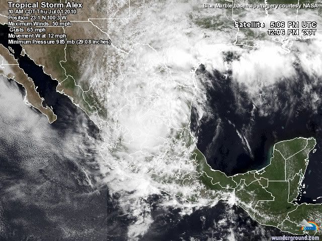
Vrij normaal. Dit was de eerste juni orkaan sinds 1995.quote:Op donderdag 1 juli 2010 19:27 schreef Black_Tulip het volgende:
Alex? Nummer 1 pas dus? Ben ik gek of begint het seizoen laat dit jaar?
Eigenlijk is het seizoen dus vroeg begonnen.quote:Op donderdag 1 juli 2010 19:41 schreef aloa het volgende:
[..]
Vrij normaal. Dit was de eerste juni orkaan sinds 1995.
En de link naar het vorige deel mag nog in de OP.
Linkje toegevoegd.quote:Op donderdag 1 juli 2010 19:43 schreef Light het volgende:
[..]
Eigenlijk is het seizoen dus vroeg begonnen.
En de link naar het vorige deel mag nog in de OP.
De eerste orkaan is vroeg. De meeste stormen zijn volgens mij in de maand Augustus.
quote:Op donderdag 1 juli 2010 20:01 schreef Co_OL het volgende:
Zou Alex in de Pacific opnieuw tot leven komen?
Kans is erg klein door de hoge bergen in Mexico

quote:Storm Alex weakens over Mexico
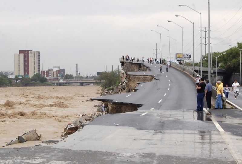
MONTERREY, Mexico, July 1 (Reuters) - Hurricane Alex weakened to a tropical storm on Thursday as it moved across northeastern Mexico, dumping heavy rain that flooded a major city as U.S. companies began to restart halted oil production.
The first named storm of the 2010 Atlantic season was powerful enough to drench the industrial city of Monterrey well inland from the coast, killing three people, washing away chunks of surrounding highways and turning dry desert beds into turbulent rivers.
Flood waters in Monterrey swept some zoo animals including buffalo from their pens, and efforts to round them up were delayed by the storm conditions. Floods sucked a 12-tonne statue of Mexico's revered Virgin of Guadalupe off its perch on the bank of the city's normally dry Santa Catarina river.
"The damage is enormous. A river burst its banks and we have people trapped on the roofs of their houses," said Mayor Martin Zamarripa of the town of Hualahuises, outside Monterrey.
Tens of thousands of residents were without water and electricity and more than 4,000 people were moved to shelters in the city 140 miles (230 kms) south of McAllen, Texas.
Het is opvallend rustig in de West Pacific. Meestal is het daar drukker dan b.v. in de oost pacific of Atlantische Oceaan. Volgens mij is daar de afgelopen maand niets geweest.
Idd..quote:Op vrijdag 2 juli 2010 11:51 schreef aloa het volgende:
Het is opvallend rustig in de West Pacific. Meestal is het daar drukker dan b.v. in de oost pacific of Atlantische Oceaan. Volgens mij is daar de afgelopen maand niets geweest.
Het is daar echt enorm rustig..
Ik volg vanaf 2004 een beetje de stormen en zo maar heb sinds toen nog niet zo weinig actieviteit gezien in W.Pacific
terwijl in dat gebied de meeste stormen voorkomen.quote:Op vrijdag 2 juli 2010 12:02 schreef SoldMayor het volgende:
[..]
Idd..
Het is daar echt enorm rustig..
Ik volg vanaf 2004 een beetje de stormen en zo maar heb sinds toen nog niet zo weinig actieviteit gezien in W.Pacific
Eerdaags zal het ook daar wel losbarsten.
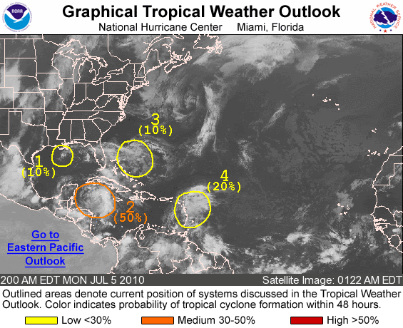
Nieuw gebied vlakbij de olievlek 

quote:1. A WEAK NON-TROPICAL LOW PRESSURE AREA...ASSOCIATED WITH A FRONTAL
ZONE...CENTERED OVER THE EXTREME NORTHEASTERN GULF OF MEXICO IS
EXPECTED TO DRIFT WESTWARD DURING THE NEXT DAY OR TWO. THIS LOW
WILL BE MONITORED FOR ANY SIGNS OF TROPICAL OR SUBTROPICAL
DEVELOPMENT. THERE IS A LOW CHANCE...10 PERCENT...OF THIS SYSTEM
BECOMING A TROPICAL OR SUBTROPICAL CYCLONE DURING THE NEXT 48
HOURS.
ELSEWHERE...TROPICAL CYCLONE FORMATION IS NOT EXPECTED DURING THE
NEXT 48 HOURS.
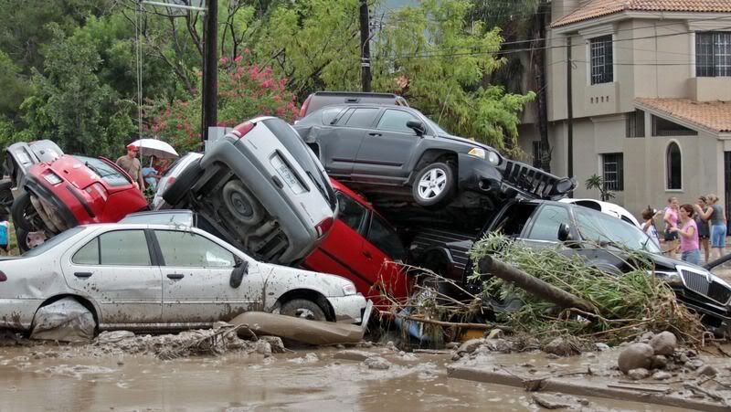
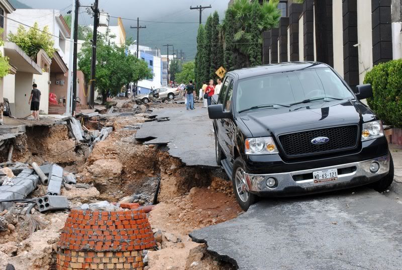
Dodelijke regenval door Alex in Mexico
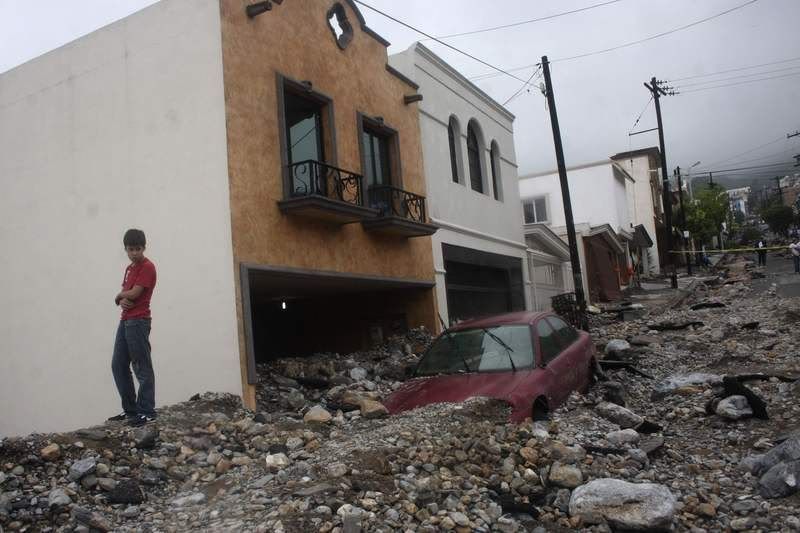
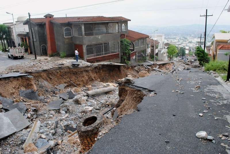
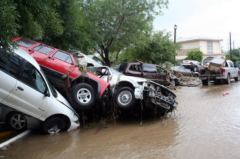
MONTERREY - De tropische storm Alex, die tot in de nacht van woensdag op donderdag orkaankracht had, heeft in het noordoosten van Mexico geleid tot zware regenval. Daardoor zijn zeker zes mensen om het leven gekomen.
Dat heeft de gouverneur van de Mexicaanse staat Nuevo León vrijdag (lokale tijd) gezegd.
Het dagelijks leven in de staatshoofdstad Monterrey, met bijna 4 miljoen inwoners de derde stad van Mexico, is tot stilstand gekomen.
Rivieren zijn buiten hun oevers getreden, huizen raakten beschadigd en bomen werden ontworteld. Door geknapte hoogspanningskabels zitten meer dan tienduizend mensen zonder stroom.
Orkaankracht
Alex was enkele weken geleden ontstaan op de Caribische Zee. In Nicaragua, El Salvador en Guatemala kostte de tropische storm aan zeker elf mensen het leven.
Door het warme water van de Golf van Mexico zwol de wervelwind aan tot orkaankracht. Woensdagavond kwam Alex aan land bij de grens van Mexico en de Verenigde Staten.
nu.nl

2 x 10% nu. Zelfde gebied als waar Alex ontstond. Dat bovenste gebied ligt precies boven de olievlek.
Alex was dan wel geen extreem krachtige orkaan, in Mexico heeft de storm op drie dagen voor de hoeveelheid neerslag van één jaar gezorgd. De ravage was dan ook enorm in de meest welvarende stad van Mexico, waar zes mensen om het leven kwamen.


quote:However the wave in the western Caribbean (96L) has a much better overall chance to develop, and could in the next few days. If it were to form it would most likely take the westerly track and wind up in Mexico. The situation is slightly different than with Alex, so it'll require monitoring by those in the Gulf through the week.
Het is nu een Tropische Depressie (35 miles/uur).
Lijkt erop dat de 2e storm met een naam in aantocht is.
Dat gaat dan Bonnie worden.
Lijkt erop dat de 2e storm met een naam in aantocht is.
Dat gaat dan Bonnie worden.
Not yetquote:Op zondag 4 juli 2010 22:26 schreef aloa het volgende:
Het is nu een Tropische Depressie (35 miles/uur).
Lijkt erop dat de 2e storm met een naam in aantocht is.
Dat gaat dan Bonnie worden.
van mij mag het ff rustig blijvenquote:Op maandag 5 juli 2010 08:15 schreef aloa het volgende:
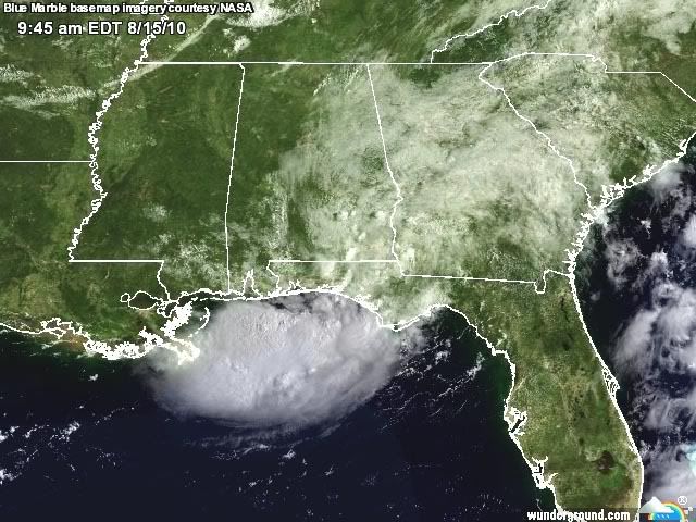
50% nu. En het lijkt druk te gaan worden.
[ afbeelding ]
moet woensdag via mexico naar guatemala....
Er zijn nu nog 3 gebieden over. 2x 10 % en een gebied met 40% kans op tropisch storm.
Die van 40% zit in de buurt van Quatemala en mexico
http://www.nhc.noaa.gov/gtwo_atl.shtml
[ Bericht 0% gewijzigd door #ANONIEM op 05-07-2010 15:33:17 ]
Die van 40% zit in de buurt van Quatemala en mexico
http://www.nhc.noaa.gov/gtwo_atl.shtml
[ Bericht 0% gewijzigd door #ANONIEM op 05-07-2010 15:33:17 ]
quote:
The first area, 95L in the Gulf, is a very small low pressure area that, for a bit yesterday, spun up quite a bit. Even though in all likelihood nothing will ever develop out of the system, it still needs to be watched because it is so small and so close to land. It has the potential to spin up very quickly because of the small size, but more likely to spin out/down ever faster. Conditions around it favor no development.
The second area being tracked is the tropical wave (96L) in the Western Caribbean. It has the best chance,currently, of all the areas to develop, but looks to remain on the weaker side. Looking at satellite imagery this morning it is not looking that great. It is on the edge of a shear zone, and it has ok outflow, but it hasn't really persisted enough. It still has a fairly high chance of development, but just not today. If this one develops, it is most likely going to stay weak. It is bringing rainfall to the Caymans and the Yucatan.
With 96L being a weaker system it implies a more westerly move, but the overall patter is less so than it was for Alex. Recon was scheduled to go out to the system today, but it was canceled because of how poorly organized it looks this morning. They may try again tomorrow.
The final wave is in the east Caribbean which may be worth watching later in the week when it arrives in the western side, but until then it'll just be watched.
The area northeast of the Bahamas is now off the list.

Toch nog redelijke kans op opwaardering tot tropische storm. Bonnie on it's way?quote:Bonnie heading for South Texas?
A week after Hurricane Alex slammed onshore, a new tropical system that is being monitored for development will target South Texas and northeastern Mexico on Thursday.
Despite tracking well away from the oil spill area, the system still threatens to disrupt cleanup and containment efforts in the northern Gulf and could lead to flooding problems along and inland of the Texas Coast.
Latest on the Tropical System
The system being monitored for development has just exited the northern Yucatan Peninsula. The system is rather disorganized with no thunderstorms wrapping around a well-defined center, after being beaten up by the large land mass.
The system could become better organized as it heads northwestward. Enough strengthening could take place that the second tropical depression or tropical storm of the season develops by midday Thursday.
The next tropical storm in the Atlantic Basin would acquire the name "Bonnie."
The water in the western Gulf of Mexico is warm enough to support strengthening. Strong winds high in the atmosphere, also known as wind shear, will be absent.
Current forecast models indicate that if a tropical storm does develop, the system will probably press inland too quickly to intensify into a hurricane. South Texas or far northeastern Mexico is where the system should move onshore on Thursday, although perhaps farther north than Alex's landfall.
Even if development does not take place, the system threatens to unleash drenching thunderstorms around and north of its center. Additional rainfall on already soaked South Texas and northeastern Mexico could lead to new flooding problems.
For now it appears the heaviest rain would fall along the middle Texas coast, due to the lopsided nature of the system at this time.

nou, ben op.. 6000meter er recht overheen gegaan..
een beetje turbulentie.. en dat was het dan.
vele groeten uit Guatemala.
een beetje turbulentie.. en dat was het dan.
vele groeten uit Guatemala.
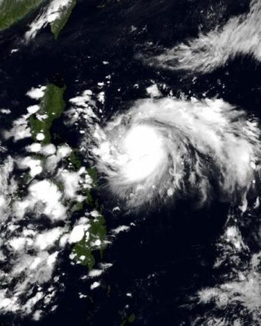
Tropische storm Conson bij de Filipijnen
[ Bericht 6% gewijzigd door #ANONIEM op 12-07-2010 11:22:18 ]
[ Bericht 6% gewijzigd door #ANONIEM op 12-07-2010 11:22:18 ]
Deze gaat recht op de Filipijnen af. Als een categorie 1. Nu heeft deze storm een windveld van 112 km/uur en windstoten tot 136 km/uur.
9 doden op de Filipijnen.
quote:Tyfoon Conson geselt noorden Filipijnen
(Novum/AP) - De eerste tyfoon die dit jaar de Filipijnse kust bereikte, heeft woensdag stevig huisgehouden in de hoofdstad Manilla. Straten overstroomden en elektriciteitskabels braken af, met stroomstoringen als gevolg. Zeker negen mensen verloren het leven, terwijl tien vissers worden vermist.
Tyfoon Conson raasde met windsnelheden van 120 kilometer per uur over de provincie Quezon, gelegen op het eiland Luzon. Hier zwakte Conson af tot een tropische storm die verder noordwaarts Manilla een uur of twee geselde met harde windstoten en slagregens. Daarna boog Conson af richting de Zuid-Chinese Zee. Verwacht wordt dat hij later deze week ten westen van Macau het Chinese vasteland bereikt.
Onder de doden zijn een vrouw en kind die in de provincie Cavite, ten zuiden van Manilla, door een vallende boom werden getroffen. Een ander kind verdronk toen het in Novelata in een snelstromende rivier viel. Nog twee kinderen overleden toen een boom op hun huis viel en een 47-jarige vrouw werd geëlektrocuteerd door een afknappende elektriciteitskabel. In de provincie Camarines Norte kwamen nog eens drie mensen om.
Negentien vissers werden vermist nadat hun bootjes in het noodweer omsloegen. De kustwacht zette een zoekactie in touw en wist negen vissers te redden.
bron
Reuters:
quote:Conson kills 26 in the Philippines
Typhoon Conson has killed 26 people so far in the Philippines. Phot:Reuters
The first typhoon of the year to hit the Philippines has killed at least 26 people and left millions without electricity on the main island, Luzon. President Benigno Aquino criticised weather forecasters who'd failed to predict that the storm would hit the capital, Manila. In the meantime, Macau has raised its No.1 typhoon signal as Conson moves over the South China Sea towards Western Guangdong. And, the Hong kong Observatory says it will consider tomorrow whether to raise the strong storm signal number one.

quote:
 Op
Op Ik las het vanmorgen
Is gewoon hetzelfde. Hieronder een kaartje om het duidelijk te maken.quote:Op woensdag 14 juli 2010 19:21 schreef j95 het volgende:
[..]
Ik las het vanmorgenDan gelijk mijn eerste vraag, is er een verschil tussen een tyfoon en een orkaan?
quote:Dodental tyfoon Filipijnen loopt op
MANILLA (ANP) - Het dodental van de tyfoon Conson op de Filipijnen is opgelopen tot zeker 36. Dat hebben de autoriteiten in Manilla donderdag meegedeeld. Zeker 46 mensen worden nog vermist. Bijna negenduizend mensen zijn dakloos geworden en hebben hun toevlucht gezocht in een opvangkamp.
Conson is de eerste tyfoon van het seizoen. Hij raasde dinsdagavond laat over het eiland Luzon, waarop de hoofdstad Manilla ligt. De hoofdstad zelf, waar ongeveer elf miljoen mensen wonen, had vooral woensdag van de wind te lijden. De Filipijnen worden elk jaar getroffen door ongeveer twintig tyfoons. De archipel ligt in de zogeheten tyfoongordel in de Stille Oceaan.
bron
Het begint weer wat drukker te worden.. belooft nog wat aangezien Aug. en Sep. de drukste maanden zijn wereldwijd voor stormen 
Conson is inmiddels weer terug naar typhoon cat.1 status...
06E is nog niet echt spannend....
En 2 gebieden in de atlantic

Conson is inmiddels weer terug naar typhoon cat.1 status...

06E is nog niet echt spannend....
En 2 gebieden in de atlantic
quote:Tientallen vissers verrast door zware tyfoon op Filipijnen
Op de Filipijnen zijn tientallen vissers verrast door een zware tyfoon. Al zeker 38 mensen kwamen om het leven door de storm.
Hulptroepen hopen nog een paar van de 29 vermiste vissers uit het water te halen, maar de tijd dringt en de slachtoffers lopen het risico op onderkoeling. De kustwacht zoekt vooral in de baai van Manila. Sommige vissers zouden op één van de eilandjes gestrand kunnen zijn.
De Filipijnen liggen in het centrum een tyfoon-rijk gebied. Jaarlijks krijgen ze te maken met zo'n 20 tropische stormen en daarbij komen honderden mensen om het leven. Deze tyfoon kreeg de naam Conson en is de eerste van het seizoen. Veel inwoners van Manila waren verrast door de enorme kracht van Conson.
De storm vernielde enkele voorsteden van Manila en plaatste de hele hoofdstad zonder stroom. Het leven kwam voor de twaalf miljoen inwoners letterlijk tot stilstand. De stroompanne zou nog enkele dagen kunnen duren, tot woede van bedrijfsleiders die een economische ramp vrezen. Volgens een Chinees weerstation is Conson nu op weg naar China. (gb)
bron
quote:Tyfoon eist steeds meer levens in Filipijnen
Het dodental door de tyfoon Conson in de Filipijnen is tot zeker 53 opgelopen. Dat hebben de autoriteiten in de hoofdstad Manilla zaterdag meegedeeld. Zeker 85 mensen worden vermist.
Conson is de eerste tyfoon van het seizoen. Hij raasde deze week over het noorden van de Filipijnen. Bij het passeren van de tyfoon viel de regen met bakken uit de hemel en werden windsnelheden tot 120 kilometer per uur gemeten. Bijna 20.000 huizen zijn beschadigd, vooral door aardverschuivingen en de harde wind.
De Filipijnen worden elk jaar getroffen door ongeveer twintig tyfoons. De archipel ligt in de zogeheten tyfoongordel in de Stille Oceaan.
bron
quote:Dodental loopt op tot 65
ij de doortocht van tyfoon Conson op de Filipijnen zijn al zeker 65 mensen om het leven gekomen. Er zijn nog 87 vermisten, deelde de overheid vandaag mee. Vooral het eiland Luzon werd zwaar getroffen. Er werden zowat 19.000 huizen beschadigd.
Het merendeel van de slachtoffers verdronk, werd geraakt door een boom of geëlektrocuteerd. De tweede tyfoon van het jaar haalde windsnelheden tot 150 kilometer per uur.


Zie ook
Tyfoon eist steeds meer levens in Filipijnen
Dat is niet mis, en nu is China aan de beurt:
quote:De cycloon is vrijdag in Zuid-China aan land gekomen. Met windsnelheden tot 126 kilometer per uur raasde de storm over het eiland Hainan.


W.Pacific komt eindelijk tot leven.. nouja eerder helaas..
Door typhoon conson nu:
Phillipijnen: 68 doden en 84 vermisten
China: 2 doden
Vietnam: 1 dode en tientalle vermisten..


quote:A well developed tropical wave currently bringing strong winds and rough seas north of Puerto Rico could develop into a tropical system by the weekend.
According to AccuWeather.com hurricane meteorologist Dan Kottlowski, there is high potential for this tropical wave to evolve into a tropical depression later on this week.
Wind shear is currently hindering any tropical storm organization of this system. However, as the wave moves swiftly west, this shear will diminish over the next few days.
If the wave were to develop into a tropical storm, models predict the system moving into the eastern Gulf of Mexico by the weekend.
The oil spill area over the Gulf of Mexico could be threatened this weekend by enhanced thunderstorms, rough seas and gusty winds.
Oil containment booms are rendered useless in rough seas, and skimming vessel operation have the potential to be delayed.
70% inmiddels
In azie is Tropical Storm Chanthu opgewaardeerd. Wordt nog een Cat.1 orkaan voor hij aan land gaat. HongKong wordt in elk geval gespaard. Maar het zal weer een bak water opleveren voor het reeds eerder getroffen gebied
In azie is Tropical Storm Chanthu opgewaardeerd. Wordt nog een Cat.1 orkaan voor hij aan land gaat. HongKong wordt in elk geval gespaard. Maar het zal weer een bak water opleveren voor het reeds eerder getroffen gebied
Zal d'r om hangen of het een naam krijgt denk ikquote:7:00 AM Update 21 July 2010
The tropical wave north of Hispaniola (97L) has diminished in activity, but overall development chances are still high for the next 48 hours, at around 60%.
The good news is that it will likely remain weaker, which means a more westerly track, at least in the short term, is more likely. The most likely scenario at the moment is rain or a moderate Tropical Storm approaching south Florida Friday or Saturday, but it could take longer if the forward motion of the system remains slow. If it remains weak longer, the further south it would likely stay, and may miss Florida to the south (although South Florida may still get rain out of it)

Als deze niet te snel gaat, dan kan het wat gaan worden idd.
Er is nogal wat windshear in de richting van Florida.
http://weather.myfoxtampa(...)s/wrf/wrf_shear.html
Er is nogal wat windshear in de richting van Florida.
http://weather.myfoxtampa(...)s/wrf/wrf_shear.html
Niet helemaal uit het niets... was een gebied dat eerder deze week al werd gevolgd maar leek uit te doven.
Geldt trouwens nu voor beide... 40%... ik verwacht er niets meer van
Flink wat regen, dat wel
Geldt trouwens nu voor beide... 40%... ik verwacht er niets meer van
Flink wat regen, dat wel
Boven Venezuela en die eilandjes hangt een systeem dat ook nog potentieel heeft voor komende week. Staat nog niet op de kaart.
Invest 98 begint wel de draaiende vorm van een orkaan te krijgen. Deze heeft volgens mij een grotere kans om wat te worden dan Invest 97.

Typhoon CHANTHU is als categorie 1 aan land gegaan bij China. De ellende wordt daar alleen maar groter en groter.
zie ook: Overstromingen Azie: Honderden doden en vermisten
zie ook: Overstromingen Azie: Honderden doden en vermisten

quote:WSI cuts Atlantic Hurricane forceast
NEW YORK (Reuters)—Private weather forecaster WSI Corp. cut its forecast for named storms in the 2010 Atlantic hurricane season on Tuesday but still sees an active season, with water temperatures and wind conditions conducive to violent storms.
In its latest tropical storm update, WSI called for 19 named storms, down from 20 in its June forecast, but maintained its outlook for 11 hurricanes and five intense hurricanes of Category 3 or higher.
The 2010 forecast is well above the 1950-2009 averages of 10 named storms, six hurricanes, and twp intense hurricanes.
"Record warm tropical Atlantic Ocean temperatures and an enabling wind shear environment should result in a very active tropical season this year," said Todd Crawford, WSI's chief meteorologist.
The disappearance of the El Niño event and a decrease in vertical wind shear both point to the potential for more Atlantic storms, WSI said.
A slow start to the hurricane season led to the downward revision in named storms. A pocket of dry air in the Atlantic is likely to limit development in the near term, WSI said, while August to October is expected to be a very active period.
WSI's models also indicate that the area from the Outer Banks of North Carolina northward to Maine is twice as likely as normal to experience a hurricane this year.
"Our model suggests that the threat to the Northeast coast this season is on a par with that in Florida and the Gulf coastal states," WSI said.
HAARP at workquote:Op donderdag 22 juli 2010 12:21 schreef aloa het volgende:
Typhoon CHANTHU is als categorie 1 aan land gegaan bij China. De ellende wordt daar alleen maar groter en groter.
zie ook: Overstromingen Azie: Honderden doden en vermisten
[ afbeelding ]

Inderdaad ja, nu 100%
Ben benieuwd hoe zwaar deze nog gaat worden.
Ze mogen de boel wel gaan evacueren daar bij al die olietroep.
Ben benieuwd hoe zwaar deze nog gaat worden.
Ze mogen de boel wel gaan evacueren daar bij al die olietroep.
Ik meen dat ze een aantal dagen nodig hebben om alles daar weg te krijgen. De boel ligt er dan zo'n 2 weken stil. Stel dat er dan weer een storm achter aan komt, dan zit je zo 3/4 weken verder.quote:Op donderdag 22 juli 2010 14:59 schreef Frutsel het volgende:
Volgens mij zijn de meeste mensen uit voorzorg al weggehaald
quote:
[..]
Ik meen dat ze een aantal dagen nodig hebben om alles daar weg te krijgen. De boel ligt er dan zo'n 2 weken stil. Stel dat er dan weer een storm achter aan komt, dan zit je zo 3/4 weken verder.
Kans is vrij groot dat er meer stormen komen. Augustus en September drukste maanden.
Dus hopen dat de kap het houdt
Inderdaad ja. Is daar op zo'n diepte iets te merken van zo'n storm?quote:Op donderdag 22 juli 2010 15:05 schreef Frutsel het volgende:
[..]
Kans is vrij groot dat er meer stormen komen. Augustus en September drukste maanden.
Dus hopen dat de kap het houdt
quote:Track Forecast for 97L
The storm is in a fairly straightforward steering current environment, and 97L should progress steadily to the west to west-northwest through Saturday. This will bring the storm ashore over the Florida Keys or South Florida on Friday, and into the Gulf of Mexico on Saturday. The latest set of model runs from 2am EDT (6Z) had the advantage of having data from a flight of the NOAA jet last night, so we have higher confidence than usual in the track of 97L over the next two days. The location of 97L's final landfall along the Gulf of Mexico coast has the usual uncertainties for 3 - 4 days, with the various models calling for landfall somewhere between the upper Texas coast and the Florida Panhandle coast. Given the uncertainties, the move halt operations in the Deepwater Horizon blowout recovery effort are probably wise.Intensity Forecast for 97L
The primary detriment to development of 97L for the next three days will be the presence of the large upper-level low to its west. As long as this low remains in its present location, relative to 97L, it will bring wind shear of about 20 knots and dry air into the storm. This will limit the intensification potential of 97L to no more than about 10 - 20 mph per day. If the upper-level low picks up speed and pulls away from 97L, the storm may be able to intensify at a faster rate. None of the computer models is calling for that to happen, but it is possible. I put the odds of 97L making it to hurricane strength in the Gulf of Mexico at 20%
quote:
[..]
Inderdaad ja. Is daar op zo'n diepte iets te merken van zo'n storm?
Lijkt me wel degelijk van belang hoe krachtig dus de orkaan is. Een tropische storm of Cat.1 orkaan zal misschien geen schade doen, maar vanaf cat.3 zou ik me zeker zorgen makenquote:Effect Hurricanes on Deepwater Horizon oil spill?
Hurricanes roaring across the Gulf of Mexico create strong enough underwater waves to dig up and potentially bust open oil pipelines that run across the ocean floor, according to a new study that recorded the currents created by the massive storms.
The massive Deepwater Horizon oil spill in the Gulf has focused attentions on the potential for more such environmental disasters, particularly now that the 2010 hurricane season has started. Scientists and officials are not only worried about how a storm might exacerbate the current spill, but the potential for it to cause another one, possibly by causing a rupture in an oil pipeline.
At least 31,000 miles (50,000 kilometers) of pipelines snake across the floor of the Gulf, according to the Minerals Management Service, and hurricanes have long been known to cause a range of damage to them, from dents to full ruptures.
After 2004's Hurricane Ivan, the MMS cited 168 pipeline damage reports; after Rita in 2005, it was 243; and there were 299 in the wake of devastating Hurricane Katrina, said Bill Teague of the U.S. Naval Research Laboratory at Stennis Space Center in Mississippi.
The numbers Teague cited were based on a 2006 MMS report stated that Ivan "produced high levels of pipeline damage, many resulting from mudslides and excessive movement in the Mississippi Delta region." The report listed separations of pipelines and rises as the No. 1 type of damage reported from the 168 cases, with "unknown" coming in at No. 2 with 25 incidents and bent risers at No. 3 with 24 reports. Other types of damage included dents, pipeline movements and kinks.
Teague's study did not investigate whether any of these cases of damage had resulted in a leak
Maakt trouwens niet uit of er nog een orkaan komt.
Morgen komt die Tsunami in de Golf van Mexico + die gifgas bel
Morgen komt die Tsunami in de Golf van Mexico + die gifgas bel
quote:
Maakt trouwens niet uit of er nog een orkaan komt.
Morgen komt die Tsunami in de Golf van Mexico + die gifgas bel
Komt die tsunami ook aan land
quote:
[..]
Zal wel moeten, anders is het geen tsunami, maar meer een "rogue wave"
En waarom is dat niet uitgebreid in het nieuws enzo, of is het geen groot gevaar?
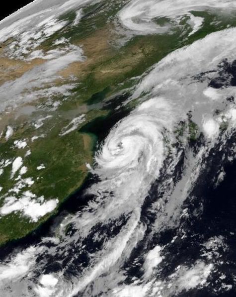
Links onder dus die grote storm die al aan land gaat en vermoedelijk geen naam krijgt.
Dan rechts in het midden Tropical Depression 3 aka Bonnie
Opvallend grote 'rode vlek' bovenin richting de Great Lakes
quote:Op donderdag 22 juli 2010 15:49 schreef j95 het volgende:
[..]
En waarom is dat niet uitgebreid in het nieuws enzo, of is het geen groot gevaar?
Omdat het een BNW topic is en wordt voorspeld door complottheoristen etc etc. Net als Quakeprediction.com Zijn geen wetenschappelijke feiten voor... al is het leuk om te lezen of volgen
quote:
[..]
Omdat het een BNW topic is en wordt voorspeld door complottheoristen etc etc. Net als Quakeprediction.com Zijn geen wetenschappelijke feiten voor... al is het leuk om te lezen of volgen
Ach so

Morgen een tsunami. Waar moet die vandaan komen dan.quote:Op donderdag 22 juli 2010 15:46 schreef Frutsel het volgende:
Maakt trouwens niet uit of er nog een orkaan komt.
Morgen komt die Tsunami in de Golf van Mexico + die gifgas bel
quote:Op donderdag 22 juli 2010 16:16 schreef aloa het volgende:
[..]
Morgen een tsunami. Waar moet die vandaan komen dan.
Instorten van de olielekwand ofzo
Tsunami alert for Mexican Gulf on July 23!!

Tropical Storm Bonnie is geboren, maar het kreng gaat 40mph! Dat is zo hard dat het zich nauwelijks kan ontwikkelen tot orkaan. Gelukkig maar, want je kan beter een TS over de olievlek hebben dan een hurricane.
Achter Bonnie ter hoogte van Puerto Rico zit ook een pak bewolking, ben benieuwd wat dat gaat doen!
Achter Bonnie ter hoogte van Puerto Rico zit ook een pak bewolking, ben benieuwd wat dat gaat doen!
Hij gaat 16 miles/uur (25 km/uur)> De windsnelheid is nu 40 Miles/uur (64 km/uur). Omgerekend naar windkracht is dat een kracht 8.
Het is een kleine storm, wat omvang betreft.
Het is een kleine storm, wat omvang betreft.
Pokeren met Castroquote:Op vrijdag 23 juli 2010 08:22 schreef Vogue het volgende:
Tropical Storm Bonnie is geboren, maar het kreng gaat 40mph! Dat is zo hard dat het zich nauwelijks kan ontwikkelen tot orkaan. Gelukkig maar, want je kan beter een TS over de olievlek hebben dan een hurricane.
Achter Bonnie ter hoogte van Puerto Rico zit ook een pak bewolking, ben benieuwd wat dat gaat doen!
Inorbit: zeg dat dan typluie triangeljosti
Beauregard: Een beetje FOK!ker laat het brood door z'n moeder smeren.
Ecosia
ek's 'n flash drive, jy's 'n floppy
Beauregard: Een beetje FOK!ker laat het brood door z'n moeder smeren.
Ecosia
ek's 'n flash drive, jy's 'n floppy
45 kts... dan zou hij omgerekend, als een windkracht 9 New Orleans treffen.quote:
Hij gaat idd steeds meer op New Orleans af.
Het water in de golf is ook lekker warm dus genoeg potentie om uit te groeien tot een cat 1/2/3/4 of 5
bronquote:Tropical Atlantic Quiet Now, But Not for Long
The tropical Atlantic remains quiet in the wake of Tropical Storm Bonnie from late last week. However, odds favor this quiet period will not last long.
The period during the second half of July is typically a quiet period.
As a large ridge builds at most levels of the atmosphere over the northern Atlantic and extends along the eastern U.S. seaboard, the tropical activity in the Atlantic notoriously ramps up at a marked pace during August.
While normal high temperatures are at their peak and actually begin to decline in August in the Northern Hemisphere, the oceans continue to absorb heat through much of the month.
While it is rare to have a tropical storm or hurricane churning waters in the nearby Atlantic or Gulf over the Independence Day holiday, it is rare not to have a tropical cyclone threatening nearby waters or U.S. coastline during the Labor Day weekend.
Things will soon change for the worse in the tropical Atlantic and we are likely to have multiple named systems in existence at the same time on one or more occasions this season according to AccuWeather.com Hurricane Expert Joe Bastardi.
Thus far we have only had two named tropical systems in the Atlantic. However, this is just the calm before the storm.
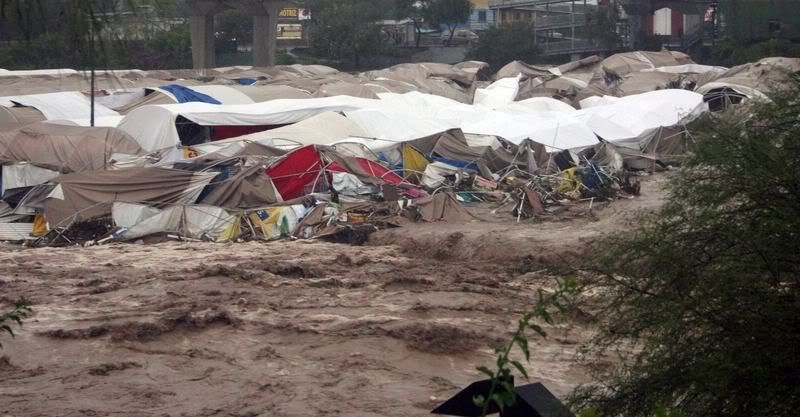
Met alle respect, maar dit had toch al veel eerder moeten gebeuren? Orkaanseizoen is allang begonnen en augustus en september zijn weliswaar de drukste maanden qua orkanen daar, maar ze hadden in juli ook Alex op hun dak kunnen krijgen.quote:Haïti bereidt zich voor op orkanen
Op Haïti worden voorbereidingen getroffen voor het orkaanseizoen om zo een nieuwe ramp te voorkomen.
Sinds de verwoestende aardbeving begin dit jaar, wonen vele Haïtianen in tentenkampen. Het Rode kruis vreest dat er veel slachtoffers vallen, mocht een orkaan over het eiland trekken. De hulporganisatie is bang dat de kampen de windstoten en regenval niet aankunnen en neemt voorzorgsmaatregelen zoals het aanleggen van schuilplaatsen.
Het meteorologisch instituut in de VS voorspelt 9 stormen die tot een orkaan kunnen uitgroeien. Het Rode Kruis schat de kans 50% dat een orkaan Haïti treft.
quote:LOOKS LIKE ANOTHER WEEK OF QUIET AND THEN IT IS TIME
Changes are coming. After a nice and quiet period, relatively speaking, since Alex, it appears that August will become quite busy. The evidence to suggest this is seen in the various global computer models which all develop African tropical waves beginning next week. The upper levels are relaxing with less and less shear, water temps are plenty warm and the large outbreaks of Saharan dust are diminishing. All of this is to be expected this time of year and comes as no surprise. There is no reason to speculate on where any future development might impact, it's just too far out in time to worry about things like that. The bottom line is that we are about to begin the most active part of the hurricane season
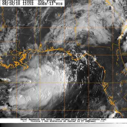
De boel komt op gang.quote:Op donderdag 29 juli 2010 23:15 schreef Co_OL het volgende:
Er is verandering aan het komen denk
[ afbeelding ]
quote:TROPICS BECOMING MORE ACTIVE AS NHC OUTLINES TWO AREAS OF INTEREST
As I mentioned yesterday, changes appear in the works as the tropics transition from being hostile for development towards more conducive. The NHC now has two areas outlined for potential tropical storm formation though both are currently low in terms of probability. The long range computer models continue to demonstrate a fairly solid consensus that we may see two storms form within the next week to 10 days. As we get in to August, just going on climatology alone, one wouuld expect an uptick in hurricane activity.
90% kans
Denk dat Colin vandaag of uiterlijke morgen wordt opgewaardeerd tot tropische depressie/storm
Denk dat Colin vandaag of uiterlijke morgen wordt opgewaardeerd tot tropische depressie/storm
quote:TROPICAL DEPRESSION COLIN LIKELY FORMING IN CENTRAL ATLANTIC
We are watching a large tropical wave and associated surface low pressure area in the open waters of the central Atlantic. The NHC gives it a 90% chance of becoming a tropical depression or storm at any time now. Overall, the conditions are seemingly favorable for development as the system moves steadily westward. However, it is curious to note that the major computer models all but lose the system over the coming days due to very unfavorable upper level winds ahead. What I am seeing is that a strong area of cyclonic flow in the upper levels of the atmosphere will be present as the low moves west. This is the opposite of what would need to be in place to allow significant strengthening. In fact, the SHIPS intensity model, which was calling for this to become a hurricane, now keeps it as a moderate tropical storm. The GFS and ECMWF models also depict the system as remaining quite weak. So while there is a lot of talk about this feature, I do not see it having much potential at this point in time. We know that things can change but as was the case with TS Bonnie recently, there is a reason the global models do not indicate much development and that reason would seem to be because it won't. It may still become a depression or even a named storm, but anything more than that would be a surprise to me as of now. There is something just not right yet in the atmosphere in the Atlantic Basin that is keeping the lid on prolific development. All of this is great news for anyone living along the coast. Will it continue for the remainder of the season?
Staat toch duidelijk Colinquote:Op dinsdag 3 augustus 2010 09:29 schreef Frutsel het volgende:
Lijkt wel of die tropische storm "Aloa" heet
Deze foto's wou ik toch met jullie delen 


Op zaterdag 28 juni 2014 @ 18:18 schreef Marie30 het volgende: Zo lief. :) Kusje :*
Op donderdag 14 juli 2016 @ 23:45 schreef GGMM het volgende: Het is altijd bijzonder gezellig als banaantje er is. :)
Op donderdag 14 juli 2016 @ 23:45 schreef GGMM het volgende: Het is altijd bijzonder gezellig als banaantje er is. :)
Net stond er Alo4 ofzoquote:
Mooie foto's maar niet echt passend bij dit topicquote:
Deze foto's wou ik toch met jullie delen
[ afbeelding ]
[ afbeelding ]
[ afbeelding ]
[ afbeelding ]
[ afbeelding ]
[ afbeelding ]
[ afbeelding ]
[ afbeelding ]
[ afbeelding ]
[ afbeelding ]
[ afbeelding ]
Colin kon land wel eens missen...
een Cat.1 orkaan aan de amerikaanse noord-oostkust echter kan een Katrina effect aka New Orleans veroorzaken
een Cat.1 orkaan aan de amerikaanse noord-oostkust echter kan een Katrina effect aka New Orleans veroorzaken
Lijkt er wel op idd.quote:
Tegen het weekend lijkt er weer een nieuwe storm te ontstaan op zo'n beetje dezelfde plaats.
Hallo,
Mijn naam is Peter zoals je al kan afleiden uit mijn gebruikersnaam.
Ben nog een "groentje" op zowel het gebied van tropische stormen als hier op het forum.
Mijn eerste vraagje naar jullie klinkt misschien wel belachelijk voor de meeste onder jullie "kenners" maar wat is de betekenis van AL04? Die 04 weet ik wel maar die AL ....?
Als er iemand is die zich geroepen voelt om een groentje als ik wat bij te leren over tropische stormen, en waar ik met vraagjes terecht kan, laat maar iets weten. Ik zal je duizend maal dankbaar zijn.
Grtz
Peter
[ Bericht 0% gewijzigd door PeterDM op 03-08-2010 20:24:37 ]
Mijn naam is Peter zoals je al kan afleiden uit mijn gebruikersnaam.
Ben nog een "groentje" op zowel het gebied van tropische stormen als hier op het forum.
Mijn eerste vraagje naar jullie klinkt misschien wel belachelijk
Als er iemand is die zich geroepen voelt om een groentje als ik wat bij te leren over tropische stormen, en waar ik met vraagjes terecht kan, laat maar iets weten. Ik zal je duizend maal dankbaar zijn.
Grtz
Peter
[ Bericht 0% gewijzigd door PeterDM op 03-08-2010 20:24:37 ]
AL staat natuurlijk voor Atlantic.quote:Op dinsdag 3 augustus 2010 19:54 schreef PeterDM het volgende:
Hallo,
Mijn naam is Peter zoals je al kan afleiden uit mijn gebruikersnaam.
Ben nog een "groentje" op zowel het gebied van tropische stormen als hier op het forum.
Mijn eerste vraagje naar jullie klinkt misschien wel belachelijk
Als er iemand is die zich geroepen voelt om een groentje als ik wat bij te leren over tropische stormen, en waar ik met vraagjes terecht kan, laat maar iets weten. Ik zal je duizend maal dankbaar zijn.
Grtz
Peter
Dit is storm 4 van het seizoen in de Atlantische Oceaan dus wordt het AL04
Ok thx SoldMayor.quote:Op dinsdag 3 augustus 2010 21:45 schreef SoldMayor het volgende:
[..]
AL staat natuurlijk voor Atlantic.
Dit is storm 4 van het seizoen in de Atlantische Oceaan dus wordt het AL04
Ik had het gedacht maar vond het nogal te simpel gezocht.
Zo simpel...quote:Op dinsdag 3 augustus 2010 21:45 schreef SoldMayor het volgende:
[..]
AL staat natuurlijk voor Atlantic.
Dit is storm 4 van het seizoen in de Atlantische Oceaan dus wordt het AL04
Ik kon het niet bedenken

Colin is alweer weg, aldus de NHC site
Wel 2 gebiedjes die potentie hebben, maar slechts 10 en 20% tot nu toe
Wel 2 gebiedjes die potentie hebben, maar slechts 10 en 20% tot nu toe
quote:WELL? WHAT ABOUT COLIN AND OTHER STORMS?
We have managed to eek out three named storms before August 15th. This is fairly significant considering one of them was category two Alex in late June. All of these systems formed from tropical waves which originated over Africa. The latest is of course TS Colin. However, I beleive, based on the data available, that Colin will never make it to the end of the work week. The reasons are fairly simple: it is too small, moving too fast, the environment is getting more hostile overall and it's still early August. Why does the last part matter? Climatology does play a key role in weather even in years like this where we are expecting a very busy hurricane season. The major uptick in activity does not begin, over the last 100 years, until about mid-August. It's that time frame, from August 15 through the end of October that the tropics are most active- in any given year. As for Colin? Obviously we never discount completely something that is heading towards land but I am confident that it will not amount to much considering the hurdles it will have to over come. Obviously, we'll watch it just to be sure...
Colin was zijn naam niet waardig. Benieuwd of Danielle lang op zich zal laten wachten nu en of deze meer beweging in de atmosfeer zal teweeg brengen.
Heeft er ooit eens iemand berekent in welke intensiteit de TS elkaar opvolgen? Hiermee bedoel ik het gemiddelde aantal dagen die verstrijken tussen 2 stormen.
Heeft er ooit eens iemand berekent in welke intensiteit de TS elkaar opvolgen? Hiermee bedoel ik het gemiddelde aantal dagen die verstrijken tussen 2 stormen.
Nee volgens mij niet maar als je zin hebt kan je hier de geschiedenis van alle stormen zien en een mooie berekening makenquote:Op woensdag 4 augustus 2010 11:23 schreef PeterDM het volgende:
.
Heeft er ooit eens iemand berekent in welke intensiteit de TS elkaar opvolgen? Hiermee bedoel ik het gemiddelde aantal dagen die verstrijken tussen 2 stormen.
Die is er niet. Er zijn alleen de seizoenen en in die seizoenen kan het heel rustig zijn, maar er kunnen ook 2 stormen tegelijk zijn. De maanden Augustus en September zijn het drukst. Dus er kan nog van alles komen.quote:Op woensdag 4 augustus 2010 11:23 schreef PeterDM het volgende:
Colin was zijn naam niet waardig. Benieuwd of Danielle lang op zich zal laten wachten nu en of deze meer beweging in de atmosfeer zal teweeg brengen.
Heeft er ooit eens iemand berekent in welke intensiteit de TS elkaar opvolgen? Hiermee bedoel ik het gemiddelde aantal dagen die verstrijken tussen 2 stormen.
Nog een vraagje. 
Kan het, of is het ooit al eens voorgekomen in het verleden dat 2 stormen samen smelten en zo een nieuwe storm vormen die dan ook de eerst volgende naam uit de lijst krijgt?
Ja wadde! Wat een vragen he.
Kan het, of is het ooit al eens voorgekomen in het verleden dat 2 stormen samen smelten en zo een nieuwe storm vormen die dan ook de eerst volgende naam uit de lijst krijgt?
Ja wadde! Wat een vragen he.
Volgens mij maak je gewoon een werkstuk op school ofzo?
en nee, das volgens mij nog nooit voor gekomen
en nee, das volgens mij nog nooit voor gekomen
Dat ik nog broeken heb vesleten op de schoolbanken is al hééél lang geleden hoor. 
Toch zeker bedankt voor je antwoord.
Toch zeker bedankt voor je antwoord.
volgens het NHC is die kans op een herintreding van Colin nu 40%
quote:WILL COLIN STRIKE BACK?
The NHC is giving the remnants of TS Colin a 40% of redevelopment. The computer models seem to suggest that it has a chance of making a comeback as it moves in to the western Atlantic over the next few days. Upper level winds could become more conducive for Colin to reorganize and develop a closed low level circulation center. Right now, it looks as though even if it were to stage a comeback that it would stay off the Southeast coast. Folks in Bermuda might have a brush with some inclement weather as the system goes by but that looks to be the extent of it. We'll see what happens over the next 48 hours especially- beyond that time, Colin does have a decent chance at becoming a tropical storm again.
The other area we're watching is in the Caribbean Sea. This too has some potential for development and impact the Yucatan peninsula. None of the models suggest anything really strong coming out of this feature. It could cross over the Yucatan and head for mainland Mexico by late in the weekend- bringing more rain to the region where Alex and TD 2 impacted earlier in the season. There is a lot to keep up with as August rolls on.
Opmerkelijk bericht:
Bronquote:'New Orleans rijker na Katrina'
De Amerikaanse stad New Orleans is vijf jaar na Katrina een stuk rijker dan ervoor. Belangrijkste reden hiervoor is dat de armen die destijds voor de orkaan vluchtten of nadien de stad uittrokken, niet meer zijn teruggekeerd.
Dat staat in een rapport van het gerenommeerde Brookings Institution en de Greater New Orleans Community Data Center, die een uitgebreid onderzoek deden naar hoe de stad er op dit moment voor staat. Volgens de cijfers bedraagt de armoede in New Orleans en omgeving 23 procent. Dat is het laagste percentage sinds 1979. Overigens is dat nog altijd veel hoger dan het landelijke gemiddelde van 13 procent in de VS.
Volgens het onderzoek zijn de lonen de laatste jaren omhoog gegaan en trekt de stad steeds meer goed betaalde banen in de kenniseconomie, in plaats van de laag betaalde industriële banen die traditioneel in New Orleans te vinden waren.
Verder is het bevolkingsaantal van New Orleans inmiddels weer op 90 procent van de 1,3 miljoen mensen die er voor Katrina woonden. De samenstelling is wel veranderd: de stad telt nu relatief meer middenklasse-inkomens en iets minder hispanics en zwarte Amerikanen. Toch blijven zwarten met 69 procent de overgrote meerderheid uitmaken van The Big Easy.
Doden
Op 29 augustus 2005 kwam orkaan Katrina aan land op de staatsgrens tussen Louisiana en Mississippi. Er vielen 1800 doden, de meesten in New Orleans doordat daar de dijken doorbraken en velen verdronken. Daarnaast waren er 300.000 ontheemden als gevolg van het noodweer.
De ramp kwam toenmalig president Bush op veel kritiek te staan omdat de federale overheid in de ogen van velen te langzaam reageerde. Katrina maakte bovendien duidelijk hoe arm en verpauperd New Orleans destijds was.
Maar vijf jaar later is de stad de weg omhoog weer ingeslagen, met betere banen, beter onderwijs en een uitgebreide dienstverleningssector, aldus het rapport.
Opgeblazen gevoel of winderigheid? Zo opgelost met Rennie!
Colin gaat recht op Bermuda af. Ze zullen blij zijn dat het bij een tropische storm blijft.
Blijft nu zeg maar een windkracht 10.
Blijft nu zeg maar een windkracht 10.


In het Atlantic basin is het alweer zo goed als rustig.
De TD en TS verdwijnen steeds weer als sneeuw voor de zon.
Is het zeewater misschien nog niet voldoende op temperatuur?
De TD en TS verdwijnen steeds weer als sneeuw voor de zon.
Is het zeewater misschien nog niet voldoende op temperatuur?
Het water is warm genoeg.quote:Op maandag 9 augustus 2010 19:29 schreef PeterDM het volgende:
In het Atlantic basin is het alweer zo goed als rustig.
De TD en TS verdwijnen steeds weer als sneeuw voor de zon.
Is het zeewater misschien nog niet voldoende op temperatuur?
Eigenlijk begint het seizoen pas echt vanaf de 2e a 3e week van augustus tot eind september
Ondanks dat ze een boven gemiddeld seizoen hebben voorspeld, vind ik het verdacht rustig. En dat wat er zich ontwikkeld is geen lang leven beschoren.
Een orkaan ontstaat niet alleen uit warm zeewater, maar heeft meerdere ingredienten nodig. Is er daar één niet van aanwezig, is er weinig potentie. De wind, circulatie, convectie, warmte etc.
Zie ook de Openingspost
Dat gaat hem worden richting new orleans en hup de olie weg uit zeequote:Op maandag 9 augustus 2010 20:16 schreef aloa het volgende:
Dat gebied in de Golf is nu 30%
Dat kan weleens wat gaan worden.
Warm water en weinig windshear.
quote:An area of low pressure heading into the eastern Gulf of Mexico by Tuesday will be watched closely for tropical development. In the meantime, it is helping to ignite torrential downpours across South Florida.
Potential For Tropical Development
The low is located about 100 miles east of Florida, and it developed along a stationary front that has been draped over the western Atlantic.
After drifting westward across Florida today into tonight, the low will emerge over warm water in the eastern Gulf of Mexico. The warm water and relatively weak wind shear over the Gulf will provide an opportunity on Tuesday into Wednesday for the low to develop into a named storm.
If this system does develop tropically, it will compete with another area of low pressure out over the central Atlantic for the next name on the 2010 Atlantic Hurricane Season list, which is Danielle.
The steering flow created by an area of high pressure dominating the Southeast could draw the system toward the central or western Gulf Coast.
Computer models currently show this feature moving west-northwestward into an area between Louisiana and the upper Texas coast toward the latter half of the week; however, this track and the intensity of the system are far from set in stone at this point in time.
People with interests along the Gulf Coast from Texas to Florida should regularly check back with AccuWeather.com for updates on the potential for tropical development over the next few days.
Ik kijk vaak op deze site.quote:Op maandag 9 augustus 2010 20:21 schreef PeterDM het volgende:
Vraagje,
Waar kan je dat zien van die windshear?
http://weather.myfoxtampabay.com/maps/WTVT/custom/models/gfs.html
Dat gebied in de Golf is nu 50%
Het gebied in de Atlantische oceaan is nog steeds 70%. Ik ben benieuwd welke Danielle gaat worden.
Het gebied in de Atlantische oceaan is nog steeds 70%. Ik ben benieuwd welke Danielle gaat worden.
quote:ATLANTIC An area or low pressure in the eastern Gulf of Mexico is being closely monitored for development. This low was east of Florida Monday morning and moved across the peninsula emerging in the eastern Gulf Monday evening.
Currently the system remains non-tropical and weak. However, atmospheric conditions are expected to become favorable for this system to become better organized later today and Wednesday. The low could begin acquiring tropical characteristics this afternoon or tonight.
Today it should bring heavy rain and thunderstorms to southern and central Florida. Rainfall amounts of 1 to 3 inches could occur south of a Tampa to Daytona Beach line. The heavy rain could lead to localized flooding, especially over southern Florida.
The system should move northwestward into the central Gulf of Mexico tonight and Wednesday. By Thursday the system could be steaming toward the central Gulf coast.
Heavy rain should spread into the eastern and central Gulf coast areas Wednesday and linger in those areas through Thursday and possibly Friday.
A tropical low is located about 800 miles to the northeast of the northernmost Lesser Antilles. This low has not gotten any better organized over the past 12 to 24 hours. An upper level low to the west of the system is providing some southwesterly wind shear which could be keeping the system from developing.
If the wind shear weakens or thunderstorms become better organized around the low a tropical depression could form.
The good news is that this system is not a threat to land. It should turn northward through the central Atlantic Ocean Wednesday and Thursday.
quote:Tropical Storm Dianmu is moving toward South Korea. As of 5 am EDT Tuesday the center of Dianmu was located about 385 miles to the south-southwest of Seoul, South Korea with top winds of 60 mph.
The tropical storm is moving northward around 13 mph, but it is expected to turn toward the northeast later today. Dianmu could make a landfall near the southwest tip of South Korea early this afternoon Eastern Time.
Some slight strengthening is still possible before the tropical storm reaches South Korea. Winds could increase to near 70 mph as the system reaches land.
Heavy rain, flooding and land slides are possible as Dianmu moves across South Korea. The greatest threat of the flooding and land slides appears to be in the mountains of southern South Korea.
A weakened Dianmu could move over northern Japan late Wednesday and Thursday Eastern Time bringing some heavy rain and gusty winds.
Tropical Storm Dianmu

quote:The remnants of Tropical Depression Five are still spinning over southwestern Georgia, and the storm is headed southwards towards the Gulf of Mexico, where redevelopment into a tropical depression could occur by Tuesday. Latest long range radar out of Mobile, Alabama shows that a band of intense thunderstorms has developed over the northern Gulf of Mexico, and satellite imagery shows that this activity continues to intensify and expand in areal coverage. Most of the heavy rain is offshore, but I expect heavy rains will spread to the Florida Panhandle late this afternoon. These heavy rains will likely spread to coastal regions of Alabama, Mississippi, and Southeast Louisiana by Monday, as the center of ex-TD 5 approaches the coast and the storm begins to wind up again. By Tuesday, the GFS and HWRF models predict that the center will move off the coast, and TD 5 will be reborn again. The system may have enough time over water to become a weak tropical storm before making landfall Tuesday night or Wednesday morning over Southeast Louisiana. Wind shear is currently low, 5 - 10 knots, and is expected to remain low to moderate, 5 - 15 knots, over the next three days, favoring re-development of TD 5. NHC is giving a 20% chance that TD 5 will regenerate into a tropical depression by 8am EDT Tuesday. I think the odds are higher than this, perhaps 40%.

quote:Zowel in het Atlantisch gebied als op de Stille Oceaan is het aantal tropische orkanen tot nu toe opvallend laag.
Het Atlantisch gebied heeft tot nu toe drie tropische stormen gehad waarvan er één is uitgegroeid tot een orkaan. De verwachting was dat die seizoen juist heel actief zou gaan verlopen. Een van de redenen voor het lage aantal orkanen in dit gebied zou kunnen zijn het er meer lagedrukgebieden in de bovenlucht actief zijn (upperlevel low). Hierdoor staat er meer wind in de hogere lagen van de troposfeer waardoor tropische systemen minder kans krijgen om zich te ontwikkelen. Verder bevindt zich er op hoogte veel droge lucht waardoor het ontstaan van buiencomplexen wordt afgeremd.
Het vrijwel ontbreken van tropische stormen in met name het westelijke deel van de Stille oceaan wordt mogelijk veroorzaakt door de huidige luchtdrukverdeling die veel extremen brengt op het oostelijk halfrond (Rusland, Pakistan, China en India) en de orkaanactiviteit onderdrukt.
(Weather Underground)
All of the major models continue to predict a major pattern shift in the global atmospheric circulation late this week, which leads to breakdown of the Russian heat wave and start to the Cape Verdes hurricane season. Most of the models predict a tropical storm will form off the coast of Africa late this week, and track west-northwestward across the Atlantic. As usual, it is highly uncertain what track a storm that has yet to form might take.
The NOGAPS model is predicting the development of a strong tropical disturbance near the coast of Honduras late this week.
[ Bericht 20% gewijzigd door Co_OL op 16-08-2010 22:31:20 ]
Nieuw gebied in de Atlantische Oceaan. Nu 10%
[ Bericht 2% gewijzigd door #ANONIEM op 17-08-2010 20:17:54 ]
[ Bericht 2% gewijzigd door #ANONIEM op 17-08-2010 20:17:54 ]
Beetje jammer dat het zo rustig is. Ik verwachtte na een rustig 2009 toch wel een heftig 2010.
's Avonds een man, overdags rustig an
Kaartje voor komdende woensdag
Dat lijkt een flinke orkaan te gaan worden.
[ Bericht 23% gewijzigd door #ANONIEM op 19-08-2010 09:08:57 ]
Dat lijkt een flinke orkaan te gaan worden.
[ Bericht 23% gewijzigd door #ANONIEM op 19-08-2010 09:08:57 ]
Inmiddels het gebied bij afrika op de kaart. 20%. De verwachting is, dat deze gaat uitgroeien tot een orkaan...
Dat systeem van 20% gaat waarschijnlijk noordwestelijk, dus hij zal wel even groeien maar daarna snel in kracht afnemen door koeler water. Helaas.
's Avonds een man, overdags rustig an
Weather Underground heeft een interessant artikel over dit orkaan seizoen en speculeert over de waarom dat dit seizoen zo uitzonderlijk rustig is. Goed leesvoer.
Storm van een paar dagen terug bij Antarctica met golven van 13 meter hoog en windsnelheden die gehaald worden bij een orkaan van de 2e/3e categorie.
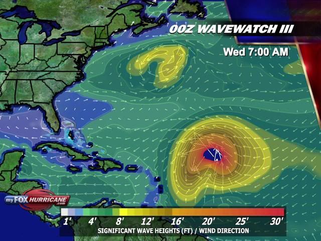
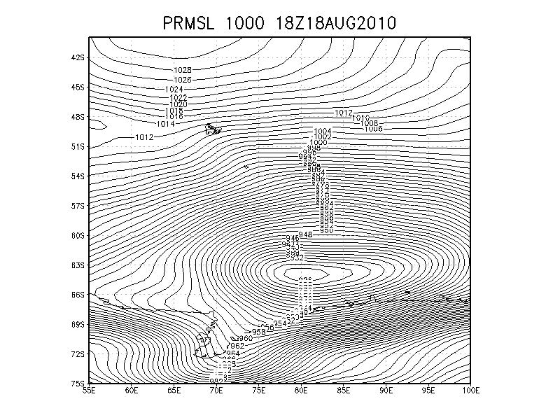
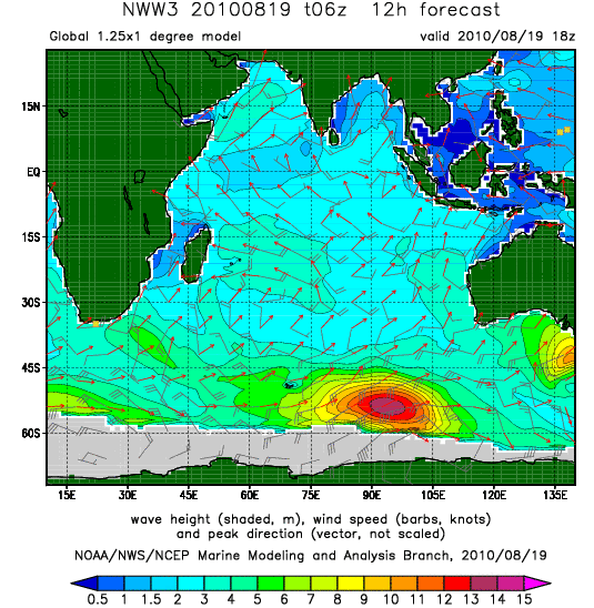
quote:Massive 926 mb extratropical storm generating huge waves off Antarctica
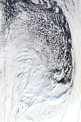
One of the most intense extratropical storms in recent years is churning up the waters near the coast of Antarctica in the South Indian Ocean. The powerful storm peaked in intensity yesterday afternoon with a central pressure of 926 mb--the type of pressure typically found in a Category 4 hurricane. Storms this intense form on average once per year, or perhaps less often, according to an email I received from Jeff Callaghan of the Australia Bureau of Meteorology. Since extratropical storms do not form eyewalls, the winds at the surface from this monster storm probably reached "only" 100 - 120 mph (equivalent to a Category 2 or 3 hurricane.) The storm is forecast to generate huge waves with asignificant wave height of 13 meters (44 feet) today, according to the NOAA Wavewatch III model (Figure 3.) I have flown into an extratropical storm this intense--in 1989, I participated in a field project based in Maine that intercepted a remarkable extratropical storm that "bombed" into a 928 mb low south of the Canadian Maritime provinces. You can read my story of that somewhat harrowing flight here.
Satellite image taken at 8:10 UTC August 19, 2010, showing the intense extratropical cyclone that has weakened to 940 mb in the South Indian Ocean near the coast of Antarctica. Image credit: NASA.
Surface pressure analysis from 18 UTC August 18, 2010, showing a 926 mb low in the South Indian Ocean, just north of Antarctica. Image credit: Jeff Callaghan, Australia Bureau of Meteorology.
Predicted wave height from the NOAA Wavewatch III model for 2pm EDT (18 UTC) today, August 19, 2010. Peak wave heights of 13 meters (44 feet) are projected over ocean areas between Antarctica and Australia. Long-period waves (19 seconds between crests) up to 7 meters (22 feet) high are predicted to affect the southwest coast of Australia by Sunday. The waves are predicted to propagate eastwards to New Zealand 8 - 9 days from now, and be a respectable 4 - 5 meters high then.

Deze lijkt wel recht op Bermuda af te gaan. Nog ver weg, maar Bermuda zal er wel het nodige van meekrijgen.

En Danielle is een feit... maar zo te zien zal 'landfall' uitblijven. Denk dat Bermuda misschien wat regen krijgt, maar geen 'directhit'
in de Oost-Pacific zien we dan Frank
in de Oost-Pacific zien we dan Frank
TS Danielle
Mogelijk vanavond opgewaardeerd tot orkaan.
En dan dit:

Mogelijk vanavond opgewaardeerd tot orkaan.
En dan dit:
Zou het er toch nog van komen dan?quote:GFS says possibly 2 more storms after Danielle coming off Africa in the next 7-10 days
De volgende ligt al voor de kust van Afrika klaar.quote:Op maandag 23 augustus 2010 12:47 schreef Frutsel het volgende:
TS Danielle
[ afbeelding ]
Mogelijk vanavond opgewaardeerd tot orkaan.
En dan dit:
[..]
Zou het er toch nog van komen dan?
http://weather.myfoxtampa(...)d_sat_w_africa_1.jpg
Danielle kon wel eens uitgroeien tot de eerste "major hurricane" van 2010
Ze groeit snel... inmiddels kan ze cat.2 halen, mogelijk cat.3
Ze groeit snel... inmiddels kan ze cat.2 halen, mogelijk cat.3

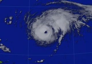
quote:Tropical Storm Danielle formed as a tropical depression over the Atlantic Ocean on August 22, 2010. By the following day, Danielle had strengthened to a tropical Storm, and had the potential to become a hurricane by evening, the U.S. National Hurricane Center (NHC) reported.
The Moderate Resolution Imaging Spectroradiometer (MODIS) on NASA’s Terra satellite captured this natural-color image of Tropical Storm Danielle at 9:15 a.m. AST (13:15 UTC) on August 23. Danielle boasts the apostrophe shape typical of tropical storms, although it lacks a distinct eye.
At 11:00 a.m. AST on August 23, 2010, the NHC reported that Danielle had maximum sustained winds of 65 miles (100 kilometers) per hour, and was expected to strengthen further over the next 48 hours. Danielle 1,025 miles (1,650 kilometers) west of Cape Verde.
En die orkaan gaat zich in rap tempo opwaarderen naar categorie 3 schat ik zo... En hij gaat ook vrij recht op Bermuda af volgens de laatste voorspellingen...
's Avonds een man, overdags rustig an
Voor Bermuda buigt ie af naar het Noorden, volgens de meeste modellen.
Volgens GFS gaat deze richting New Foundland en daarna richtin Europa.
Volgens GFS gaat deze richting New Foundland en daarna richtin Europa.
Toch lag, voor mijn gevoel athans, de koers al eerder noordelijker dan nu...
wat dat betreft geef ik burnie wel gelijk... het lijkt nu toch meer richting Bermuda te gaan dan voorheen,... neemt niet weg dat hij wegdraait, maar voor mijn gevoel later dan vanochtend het geval was
wat dat betreft geef ik burnie wel gelijk... het lijkt nu toch meer richting Bermuda te gaan dan voorheen,... neemt niet weg dat hij wegdraait, maar voor mijn gevoel later dan vanochtend het geval was
Hij ging eerder al recht op Bermuda af en is nu juist weer noordelijker bijgesteld. Kan wel zijn, dat de koers nu weer wat meer richting Bermuda is.
Kan nog alle kanten op. Als je de golfbewegingen ziet, dan gaat de gehele oostkust van de VS ermee te maken krijgen.
Kan nog alle kanten op. Als je de golfbewegingen ziet, dan gaat de gehele oostkust van de VS ermee te maken krijgen.

Danielle is nu een Categorie2 met een windsnelheid rond de 160 km/uur en windstoten tot bijna 200 km/uur.
De druk in de kern is 973 mb
De druk in de kern is 973 mb
Kaartje van Zondag
Hier is Danielle te zien met daaronder Earl. Earl lijkt dezelfde route als Danielle te volgen.
Boven Afrika is een lagedrukgebied aanwezig waar Fiona uit zou kunnen ontstaan.
In de Golf en De Caribbean lijkt het voorlopig nog rustig.
[ Bericht 0% gewijzigd door #ANONIEM op 24-08-2010 12:56:09 ]
Hier is Danielle te zien met daaronder Earl. Earl lijkt dezelfde route als Danielle te volgen.
Boven Afrika is een lagedrukgebied aanwezig waar Fiona uit zou kunnen ontstaan.
In de Golf en De Caribbean lijkt het voorlopig nog rustig.
[ Bericht 0% gewijzigd door #ANONIEM op 24-08-2010 12:56:09 ]
Danielle weer gedowngrade tot categorie 1, neerslagintensiteit vermindert wat.
's Avonds een man, overdags rustig an
quote:Steden trekken orkanen aan
Uit een nieuw wetenschappelijk onderzoek blijkt dat de textuur van een landschap de beweging van een storm beïnvloedt. Dit betekent dat huidige computermodellen aangepast moeten worden. “Hoge gebouwen in steden oefenen een grotere wrijving uit op de wervelende straalstroom”, zegt professor Johnny Chan van de universiteit van Hong Kong. “En tropische cyclonen worden door wrijving aangetrokken.”
Steden en bossen houden lucht vast. Hierdoor wordt de lucht gecomprimeerd en wordt het in de atmosfeer geduwd. De storm neemt zo in kracht toe. Daarnaast wordt het centrum van een orkaan naar steden en bossen getrokken. Een stad kan een orkaan tientallen kilometers van zijn pad laten afwijken.
Een kleine koerswijziging kan er al voor zorgen dat computermodellen falen. Daarom is het goed dat wetenschappers rekening houden met de textuur van een landschap.
Chan en zijn collega’s houden zich de komende tijd bezig met de ontwikkeling van een eigen computermodel. Zij proberen dit computermodel nog wat scherper te maken, waardoor de banen van orkanen in de toekomst nog beter voorspeld worden dan nu het geval is. Een toekomstig computermodel houdt niet alleen rekening met het terrein, maar ook met de rotatie van de aarde en de luchtvochtigheid.
Bermuda gaat het erg zwaar krijgen vrees ik... 'Late next week' moeten we de Golf van Mexico ook in de gaten houden. Heel vochtig/warm daar en waarschijnlijk veel wind shear. Ben benieuwd. Het is erg druk aan het worden momenteel in de oceanen .
's Avonds een man, overdags rustig an
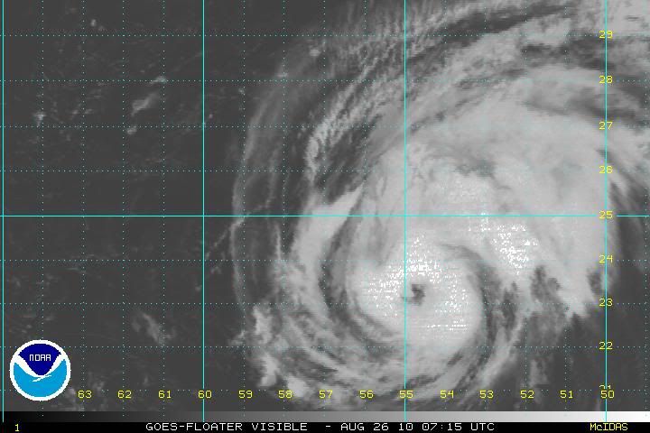
Op de onderstaande link een schitterende High Resolution satellietloop van de orkaan Danielle. Er zit een interval op van 1 minuut.
WeerDirect
WeerDirect
Weer of geen weer, altijd actueel www.onweer-online.nl
Earl inmiddels 100%

Prachtige satellietfoto zegquote:
Op de onderstaande link een schitterende High Resolution satellietloop van de orkaan Danielle. Er zit een interval op van 1 minuut.
WeerDirect

Leuk stukje film over het hoe en waarom... en vooral: the hurricanes are coming!
http://www.accuweather.co(...)he-hurricanes%29.asp
http://www.accuweather.co(...)he-hurricanes%29.asp
http://weather.myfoxtampa(...)m/models/nogaps.html
Dit model laat Danielle aan de westkant van bermuda gaan en daarna idd richting de Oostkust.
[ Bericht 8% gewijzigd door #ANONIEM op 25-08-2010 23:01:20 ]
Dit model laat Danielle aan de westkant van bermuda gaan en daarna idd richting de Oostkust.
[ Bericht 8% gewijzigd door #ANONIEM op 25-08-2010 23:01:20 ]
De V.S. heeft geluk dat er een groot hogedrukgebied boven land ligt, anders gingen al die hurricanes richting Florida e.d. Earl kon wel eens heel gevaarlijk worden. Danielle kan cat. 3 zijn wanneer zij landfall maakt in Bermuda, de hel gaat daar dan echt los.
's Avonds een man, overdags rustig an
Hier laten ze zien waarom ze denken dat Danielle gaat afbuigen en of het gaat gebeurenquote:Op woensdag 25 augustus 2010 23:03 schreef Frutsel het volgende:
inmiddels vier van de zes... is net geupdate
quote:Orkaan Frank eist levens in Mexico
Orkaan Frank heeft woensdag ten minste vier levens geëist in de Mexicaanse deelstaat Oaxaca in het zuidoosten van het land. Door hevige regenval liepen huizen onder, raakten wegen en bruggen beschadigd en liepen circa honderd dorpen in het gebied schade op. Dat berichtte de Amerikaanse nieuwszender CNN.
Frank, die windsnelheden veroorzaakt van ongeveer 120 kilometer per uur, trekt richting het noordwesten. De storm zal voorlopig niet aan land komen in de omgeving.
Inmiddels heeft Danielle een oog ontwikkeld. Het is nu weer een Categorie 2 met een hoogste windsnelheid van 160 km/uur met windstoten tot 193 km/uur. Waarschijnlijk gaat ze nog in kracht toenemen.
Bermuda gaat het zwaar krijgen. Eerst komt Danielle heel dicht in de buurt en nu lijkt Earl ook later af te buigen richting Bermuda.
Gemiddelde windsnelheid is 170 km per uur met windstoten tot net boven de 200 km per uur.
Kerndruk is 970 mb.
Danielle
Kerndruk is 970 mb.
Danielle
`Laat die hier maar komen 
Weerstation Dokkum voor het actuele weer in de Friese 11steden stad
Doe mee met het voorspellen van het weer!
Weekvoorspelling | Maandvoorspelling Augustus - Invullen tot 31 juli 23:59 | Jaarvoorspelling 2026
Doe mee met het voorspellen van het weer!
Weekvoorspelling | Maandvoorspelling Augustus - Invullen tot 31 juli 23:59 | Jaarvoorspelling 2026
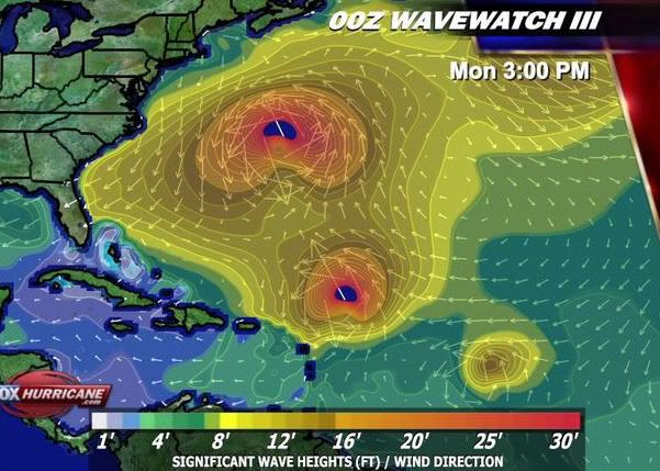
Op Bermuda worden golven van meer dan 6 meter verwacht. En een groot deel van de Oostkust kan rekenen op golven van 2,5 meter
quote:Intensity forecast for Danielle
Once Danielle recovers from its current troubles with dry air, warm 29°C SSTs combined with low wind shear of 5 - 10 knots should allow the storm to intensify. There is substantial dry air to the west and south of Danielle, though, and it is quite possible that some unexpected increase in shear could inject dry air into the hurricane at any time over the next few days. The latest SHIPS model forecast predicts that this shear will remain low, 5 - 10 knots, over the next three days, but then rapidly rise to a high 20 - 40 knots on Sunday. Danielle will probably reach peak intensity Saturday night or Sunday morning, near the time of its closest approach to Bermuda. NHC is giving Danielle a 41% chance of becoming a major Category 3 hurricane.
Track forecast for Danielle
On Saturday, a trough of low pressure that is expected to move off the East Coast of the U.S. and Canada should begin pulling Danielle due north, with the hurricane passing east of Bermuda Saturday night through Sunday. NHC is giving Bermuda a 25% chance of receiving tropical storm force winds of 39 mph or greater from Danielle, and a 1% chance of getting hurricane force winds. This is a substantial reduction from the odds given in the 5am forecast, which were 37% and 6%, respectively. The Bermuda Weather Service is predicting 15 - 20 foot waves this weekend for Bermuda's offshore waters. The most likely scenario once Danielle passes north of Bermuda is for the storm to recurve out to sea, missing the U.S. and Canadian coasts. All of the computer models currently call for this scenario. The possibility of Danielle stalling north of Bermuda and potentially tracking northwest towards the U.S. and Canadian coasts, as called for by the NOGAPS model in some of its runs yesterday, is looking less likely.
History suggests that a storm in Danielle's current location has only a 5 - 10% chance of making landfall on the U.S. East Coast. If Danielle passes east of Bermuda, as forecast, these percentages drop to less than 5%. However, Danielle will bring high surf conditions to the U.S. East Coast beginning this weekend. The latest wave forecast from NOAA's Wavewatch III model (which uses the GFS model as its prediction for the position and intensity of hurricanes), calls for waves from Danielle to begin hitting the coast of North Carolina on Saturday. These waves will build to 7 - 10 feet in the offshore waters from Northern Florida to North Carolina by Sunday. The latest near shore water forecast for Cape Hatteras calls for 5 - 8 foot waves Saturday, and 7 - 10 feet on Sunday.
Danielle is een Categorie 4 nu.
Maximale wind is ruim 217 km/uur
en windstoten tot 257 km/uur.
De kerndruk is nu 946 mb.
Danielle trekt nu wel een stuk oostelijker langs Bermuda. Dit eiland krijgt nog wel met hoge golven wind en veel neerslag te maken.
[ Bericht 0% gewijzigd door #ANONIEM op 27-08-2010 12:51:49 ]
Maximale wind is ruim 217 km/uur
en windstoten tot 257 km/uur.
De kerndruk is nu 946 mb.
Danielle trekt nu wel een stuk oostelijker langs Bermuda. Dit eiland krijgt nog wel met hoge golven wind en veel neerslag te maken.
[ Bericht 0% gewijzigd door #ANONIEM op 27-08-2010 12:51:49 ]
Het kan nog hard gaan waaien op Bermuda. Vooralsnog hebben ze daar geluk. (als de koers niet nog gaat veranderen)

Deze komt inderdaad dichtbij de Oostkust. Dichter dan Daniellequote:Op vrijdag 27 augustus 2010 00:25 schreef Co_OL het volgende:
Earl gaat naar New York
[ afbeelding ]
Cat3/4
[ afbeelding ]
http://www.wetterzentrale.de/pics/Rnamavn1808.png
Zo wordt het toch nog een druk seizoen als Fiona vandaag ook nog komt. En dan moet de september nog komen. Dan zijn vaak de meeste stormen.

Volgens mij zijn dit de 2 drukste wekenquote:Op vrijdag 27 augustus 2010 13:18 schreef SoldMayor het volgende:
Zo wordt het toch nog een druk seizoen als Fiona vandaag ook nog komt. En dan moet de september nog komen. Dan zijn vaak de meeste stormen.
Zag net op een video van Accuweather dat het hogedrukgebied boven Amerika volgende week zal verschuiven. Hierdoor zal Earl en Fiona meer 'kans' krijgen om richting de oostkust van de USA en de Golf te trekken.. En dan wordt het echt gevaarlijk.
's Avonds een man, overdags rustig an


Gaat Earl langs St. Maarten komen? Lijkt me aan de ene kant wel vet om een Hurricane mee te maken, alleen denk ik dat ik er snel genoeg van zal hebben.
Daar komt ie heel dicht in de buurt.quote:Op zaterdag 28 augustus 2010 01:38 schreef Stienn het volgende:
Gaat Earl langs St. Maarten komen? Lijkt me aan de ene kant wel vet om een Hurricane mee te maken, alleen denk ik dat ik er snel genoeg van zal hebben.
http://www.tropicalstormr(...)images/201007N_5.png
quote:Storm Earl koerst richting Sint Maarten
De Franse overheid heeft een stormwaarschuwing ingesteld voor het eiland Sint Maarten. Dit in verband met de komst van de tropische storm Earl. Dat heeft het Amerikaanse Orkaancentrum (NHC) vrijdag gemeld.
Sint Maarten bestaat uit een Frans en een Nederlands deel. De Franse overheid heeft de waarschuwing uitgevaardigd. Earl is nu nog een tropische storm, maar volgens meteorologen zal hij uitgroeien tot een orkaan. Of Sint Maarten ook te maken zal krijgen met wind van orkaankracht, laat zich nog niet voorspellen. Earl wordt maandag verwacht op het eiland.
http://www.telegraaf.nl/b(...)Maarten__.html?p=3,2
Ik moet maar snel ticket boeken
Weerstation Dokkum voor het actuele weer in de Friese 11steden stad
Doe mee met het voorspellen van het weer!
Weekvoorspelling | Maandvoorspelling Augustus - Invullen tot 31 juli 23:59 | Jaarvoorspelling 2026
Doe mee met het voorspellen van het weer!
Weekvoorspelling | Maandvoorspelling Augustus - Invullen tot 31 juli 23:59 | Jaarvoorspelling 2026
quote:Op zaterdag 28 augustus 2010 17:53 schreef Stienn het volgende:
[..]
Ah, dus maandag kan het los gaan hier.
quote:Track forecast for Earl
Earl is being steered to the west by the same ridge of high pressure that steered Danielle. As Earl approaches the Lesser Antilles on Sunday, a weakness in the ridge left behind by the passage of Danielle will allow Earl the opportunity to move more to the west-northwest, likely bringing the core of the storm just to the northeast of the northernmost Lesser Antilles Islands Sunday night and Monday morning. However, it is possible that Earl could move directly over some of these northernmost islands. NHC is giving Saint Maarten in the northern Lesser Antilles a 57% chance of receiving tropical storm force winds from Earl, and an 18% chance of getting hurricane force winds. Heavy rain squalls and tropical storm force winds should begin affecting the islands Saint Maarten, Barbuda, and Antigua late Sunday night. The odds of Earl bringing tropical storm force winds to Puerto Rico are lower--25%, according to NHC.
En een paar dagen later krijg je misschien nog bezoek van Fiona.quote:Op zaterdag 28 augustus 2010 17:53 schreef Stienn het volgende:
[..]
Ah, dus maandag kan het los gaan hier.
1tje lijkt me wel ff genoeg, heb het nog nooit meegemaakt dus het lijkt me wel gaaf aan de ene kant. Alleen denk ik dat ik het daarna ook al wel gezien heb.
rtlquote:Storm Earl op weg naar de Antillen
Op de Nederlandse Antillen is een stormwaarschuwing uitgevaardigd voor Sint Maarten, Sint Eustatius en Saba. De tropische storm Earl passeert daar morgennacht.
Weerkundigen verwachten dat de storm aantrekt tot orkaankracht. Een vliegtuig van het NHC, het Amerikaanse orkaancentrum, houdt Earl daarom de komende uren goed in de gaten.
Of de Antillen ook echt te maken krijgen met een orkaan is nog niet te zeggen. Voorlopig lijkt het zwaartepunt van de storm net ten noorden van de bovenwindse eilanden langs te trekken.
[ Bericht 3% gewijzigd door #ANONIEM op 29-08-2010 08:50:09 ]
nu.nlquote:Orkaan-waarschuwing voor Antillen
MIAMI - De stormwaarschuwing voor Sint Maarten, Sint Eustatius en Saba is veranderd in een orkaanwaarschuwing. Dit in verband met de komst van tropische storm Earl die zondagochtend volgens meteorologen zal aanzwellen tot een orkaan.
Dat maakte het Amerikaanse orkaancentrum (NHC) in de nacht van zaterdag op zondag bekend.
Earl wordt binnen 48 uur verwacht op de bovenwindse Nederlandse Antillen. Het orkaancentrum raadt mensen aan zo snel mogelijk maatregelen te nemen om hun bezittingen en zichzelf te beschermen.
Eerder vandaag werd bekend dat demissionair premier Jan Peter Balkenende de komende dagen de Nederlandse Antillen zal bezoeken.
Van zondag tot dinsdag reist de hij langs de verschillende eilanden ter voorbereiding op een slotconferentie over de nieuwe staatkundige verhoudingen binnen het Koninkrijk der Nederlanden. Zondag zal Balkenende Sint Maarten aandoen. Maandag vertrekt hij naar Curaçao.
inderdaad ja... ik ben ook benieuwd hoe die koers nog gewijzigd gaat worden. Hij trekt steeds dichter langs de kust.quote:Op zondag 29 augustus 2010 13:10 schreef Frutsel het volgende:
[ afbeelding ]
Eh... een Cat 3 gaat toch vrij dicht langs de oostkust?
Kon nog wel eens problemen opleveren
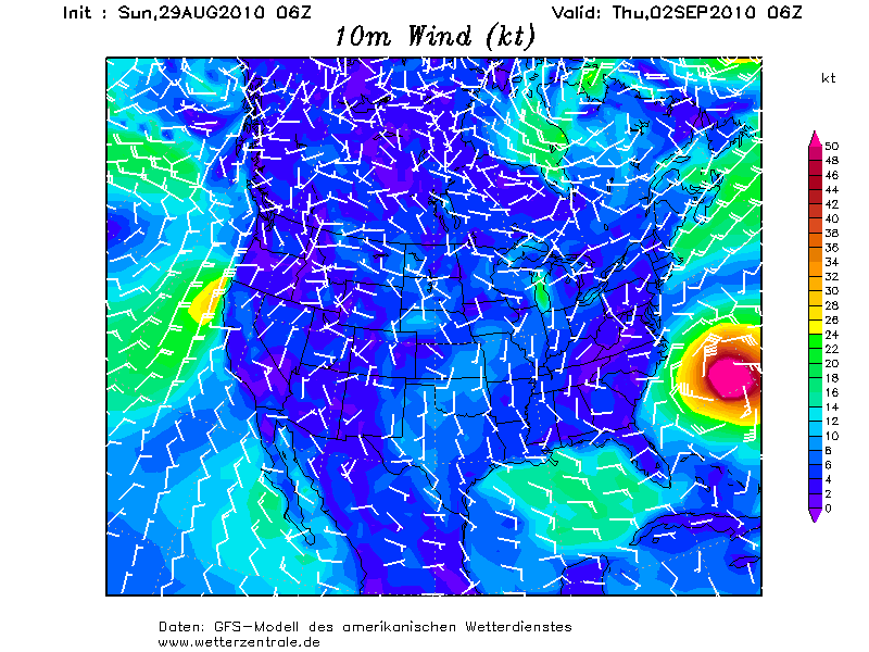


Morgen gaat hij op 39 miles langs St. Maarten. Kreeg een mooie website door van een collega hier, www.stormpulse.com
quote:Op zondag 29 augustus 2010 19:48 schreef Stienn het volgende:
Morgen gaat hij op 39 miles langs St. Maarten. Kreeg een mooie website door van een collega hier, www.stormpulse.com
quote:Twin Tropical Systems Threaten Flood Wary China
.A pair of tropical systems threaten to produce even more flooding across flood wary eastern China.
Tropical Storm 07W, dubbed Lionrock, continues to slowly spin toward the southeast China coast, near Hong Kong. Despite being a weak tropical storm, the slow-moving nature of this system has the potential to unleash very heavy rainfall in a short period of time.
The tropical storm will push inland along the southern Chinese coast, likely just east of Hong Kong, during the day on Monday. Heavy rain would be the main impact in this scenario to Hong Kong, though winds may gust between 30-40 mph.
It is also possible that the system will stall just offshore. The system would then have an opportunity to continue strengthening, potentially into a hurricane.
If this solution pans out, the exact weather pattern that unfolds this week would dictate the system's final landfall.
Rainfall totals throughout southeast China by midweek will average 10-20 inches from Lionrock. This will lead to widespread major flooding and could also trigger life-threatening mudslides.
A New Tropical Threat
A new tropical system has quickly developed and poises a new threat to portions of northeast China this week.
Tropical Storm 08W formed on Saturday, EDT, over the northern Philippine Sea and could threaten portions of northeast China by midweek and the Korean Peninsula by the end of the week.
This storm is moving northwestward and will continue to do so over the next few days, crossing Japan's Ryukyu Islands on Monday night or Tuesday, EDT. As this system moves northwestward, further strengthening is expected, and it's likely that this storm becomes a typhoon before crossing the Ryukyu Islands.
Once in the Yellow Sea, further strengthening is possible as it approaches the coast of China near the major city of Shanghai. Heavy rain and gusty winds, perhaps as high as hurricane strength, can impact the city starting on Tuesday night, EDT.
This storm will likely curve northward and head toward the Korean Peninsula by the end of the week. The storm's torrential rain will take aim on the northeastern Chinese province of Liaoning and neighboring parts of North Korea on Thursday and Friday.
The rain poses a serious danger to lives by triggering widespread flooding and mudslides. Recent torrential rain has made eastern Liaoning and nearby North Korea extremely vulnerable to new flooding problems.
Heavy rain soaked the border of China and North Korea more than a week ago. The Chinese town of Kuandian Manzu was inundated with nearly 15 inches of rain from August 19th to the 22nd.
The heavy rain brought the Yalu River (or Amnok River as it's known in North Korea) out of its banks. The rising water punctured a dike that usually protects Dandong, China, from the river.
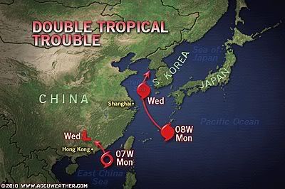
Stienn en mijn eerste orkaantje word Earl (zijn roommates hier)
update: 21:14 lokale tijd hier op sint maarten.
Regen regen regen...wind word ietsje steviger...
veel water gekocht en canned food
EDIT: Collega zegt net dat het pas om 8 uur morgenochtend los gaat hier...
Vroeg opstaan dus om alles mee te maken live updates volgen...(als inet het blijft doen)
update: 21:14 lokale tijd hier op sint maarten.
Regen regen regen...wind word ietsje steviger...
veel water gekocht en canned food
EDIT: Collega zegt net dat het pas om 8 uur morgenochtend los gaat hier...
Vroeg opstaan dus om alles mee te maken

Zag net in de nieuwe run dat het Europese model voor EARL dezelfde koers volgt als de GFS. Dat zijn de meest westelijke lijnen aldus de voorspellingen, dus de koers het dichtst bij de US Eastcoast.quote:EARL
Earl is really starting to crank up. The pressure continues to fall as its organization improves. This is not unexpected and I hope that people in the path are ready for a rough night. As I mentioned in the post from earlier today, an intensifying hurricane packs more punch (this is our team's experience from personal observations) than one that is level or weakening. As far as pin-pointing exactly where Earl will track over the next 24 hours, it's tough to call as wobbles here and there could bring the core over a certain island or, conversely, keep it off. Why do they wobble? A lot of it has to do with a hurricane spinning like a top on a table (see the movie "Inception"?) and the axis seems to move around the common area of rotation. A hurricane's core bounces around inside the larger area of circulation and so we get the wobbles instead of a perfectly straight path. In any case, the area of the northern Caribbean Sea will experience quite a squally night with some areas actually receiving hurricane conditions.
The latest data indicates that Earl should miss Puerto Rico to the north. This is obviously good news for that island. But, we cannot be absolutely sure until the center has passed by. Heavy rains and windy conditions along with rough surf are a sure bet. The weather will improve by Tuesday.
As for a possible impact on the U.S.- the latest run of the global models from late this afternoon continue to suggest that Earl will remain just far enough off the East Coast to keep the worst weather off shore. We are talking still only a hundred miles or so and that meaning the difference in a breezy day with rain and possible hurricane force winds, tidal flooding and torrential rains. I think the key remains how strong the ridge of high pressure is between Earl and departing Danielle. If it holds firm or inflates some, like a large balloon, then it could easily push Earl more west and closer to the NC coast and then Cape Cod or Maine. Folks in Nova Scotia seem especially in the line of fire and now we're looking to see if Earl goes in to the Bay of Fundy (very bad) or skirts the coast to the southeast (much better). So still no conclusion as to what Earl will do in the end. I do expect that tonight's major global model run will yield more solid clues. I know it's tough to want to know what will happen in definitive terms, but it's not usually that easy.
FIONA
For those wondering about 97L and future Fiona, it is coming. The system is very large and is taking its own sweet time to develop. While you may think this is good news, it really isn't for the longer these enormous Cape Verde tropical waves take to develop, the farther west they usually track. This may be why the ECMWF model now shows it getting in to the Gulf of Mexico going past south Florida and over Cuba. I will address this more and more throughout the week but we need to keep a calm about ourselves and deal with Earl first. Fiona-to-be is not going to impact land for several days if at all. As is always the case, we will get more pieces to this complex puzzle with each passing model cycle. I will have another update here tomorrow morning by 10am ET (and yes, I plan to be on time with this one, sorry tonight's was later than I had planned. A lot is going on and I am trying to keep up).
Fiona kon wel eens een cat 4/cat.5 worden...
Nou maar ff een update. Het is hier nu 07:48. De kern van earl gaat het komende uur op iets van 50 km langs st. Maarten. Tot nu toe valt het heel erg mee heb ik het idee, heb de hele nacht in coma gelegen. De wind word wel steeds wat sterker.quote:
50 km, dan zou je orkaankracht moeten krijgen.quote:Op maandag 30 augustus 2010 13:52 schreef Stienn het volgende:
[..]
Nou maar ff een update. Het is hier nu 07:48. De kern van earl gaat het komende uur op iets van 50 km langs st. Maarten. Tot nu toe valt het heel erg mee heb ik het idee, heb de hele nacht in coma gelegen. De wind word wel steeds wat sterker.
Gaat Danielle nou tegen de jetstream inboksen en (extratropical) landfall maken op oost-Groenland? Dat kan toch helemaal niet?
Dat gaat niet lukken inderdaad. Waarschijnlijk wordt deze meegenomen door de straalstroom, die over groenland kronkelt.quote:Op maandag 30 augustus 2010 14:34 schreef thijsdetweede het volgende:
Gaat Danielle nou tegen de jetstream inboksen en (extratropical) landfall maken op oost-Groenland? Dat kan toch helemaal niet?
http://media.weeronline.n(...)t3/10090206_3006.gif
Wel bizar veel regen misschien?quote:Op maandag 30 augustus 2010 13:52 schreef Stienn het volgende:
[..]
Nou maar ff een update. Het is hier nu 07:48. De kern van earl gaat het komende uur op iets van 50 km langs st. Maarten. Tot nu toe valt het heel erg mee heb ik het idee, heb de hele nacht in coma gelegen. De wind word wel steeds wat sterker.
's Avonds een man, overdags rustig an
Ook Fiona is inmiddels gearriveerd en ook daarachter zit alweer een nieuw gebied dat een eventueel volgende storm tot stand kan brengen
Maar Fiona lijkt (gelukkig) niet zo krachtig te worden als Earl, en het gebied daar achter heeft ook weinig kans.
Ondertussen komen de remnants van Danielle nu toch richting Europa, en gaat Earl weer een stukje dichter langs de US kust. Dat is zelfs goed voor New York en Boston, aangezien een korte landfall in North Carolina Earl wel zal verzwakken.
Ondertussen komen de remnants van Danielle nu toch richting Europa, en gaat Earl weer een stukje dichter langs de US kust. Dat is zelfs goed voor New York en Boston, aangezien een korte landfall in North Carolina Earl wel zal verzwakken.
quote:Fiona forms
Tropical Storm Fiona finally gained enough heavy thunderstorm activity to be given a name, but continues to struggle with dry air. Satellite loops show that heavy thunderstorm activity comes and goes, and there are not many intense thunderstorms near the storm's center. The storm is experiencing low wind shear of less than 5 knots, and is over warm 29°C waters. The main impediment to development continues to be dry air associated with the Saharan Air Layer (SAL) surrounding the storm. The latest SHIPS model forecast calls for shear to increase to moderate, 10 - 15 knots, by Tuesday. Fiona is moving quickly to the west, at about 24 mph. This means it is catching up to Earl, which is moving at 15 mph. By Tuesday night, Earl is expected to be a large and powerful major hurricane with a well-developed upper-level outflow channel heading clockwise out from Earl's center at high altitudes. These strong upper-level winds will bring high levels of wind shear, 20 - 30 knots, to Fiona, and probably arrest the storm's development. A scenario predicted by the GFS, GFDL, and HWRF models is for Fiona to be drawn into the low pressure wake of Earl and pass to the northeast of the Lesser Antilles. Earl would then eventually destroy Fiona through high wind shear, and by robbing the storm of its moisture. An alternative scenario, championed by the ECMWF and NOGAPS models, is for Fiona to stay far enough away from Earl that it will be able to potentially threaten the Bahamas and U.S. East Coast early next week. At this point, it is difficult to choose between these two scenarios. History suggests that a storm in Fiona's current location has a 25% chance of making landfall on the U.S. East Coast.
Fiona stelt geen ruk voor. Ben benieuwd of die tropical wave daarachter nog wat kan worden.
's Avonds een man, overdags rustig an
Achter Fiona ontstaan ook alweer 2 systemen. 1 Van die 2 systemen heeft al 50% te pakken.
's Avonds een man, overdags rustig an
De drukte is nu op volle gang!
Weerstation Dokkum voor het actuele weer in de Friese 11steden stad
Doe mee met het voorspellen van het weer!
Weekvoorspelling | Maandvoorspelling Augustus - Invullen tot 31 juli 23:59 | Jaarvoorspelling 2026
Doe mee met het voorspellen van het weer!
Weekvoorspelling | Maandvoorspelling Augustus - Invullen tot 31 juli 23:59 | Jaarvoorspelling 2026
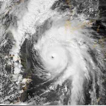
Gaston is inmiddels ook een feit. Deze lijkt het wel tot orkaan te gaan maken. Lijkt nog iets zuidelijker dan Earl te gaan.
Dit kan wel eens erg druk gaan worden. Vooral als de 1 naar het ander in 1 lijn naar de VS gaat...dat gaan dat weer miljoenen kosten.
Weerstation Dokkum voor het actuele weer in de Friese 11steden stad
Doe mee met het voorspellen van het weer!
Weekvoorspelling | Maandvoorspelling Augustus - Invullen tot 31 juli 23:59 | Jaarvoorspelling 2026
Doe mee met het voorspellen van het weer!
Weekvoorspelling | Maandvoorspelling Augustus - Invullen tot 31 juli 23:59 | Jaarvoorspelling 2026

quote:Tyfoon Kompasu aan land in Zuid Korea
De tyfoon Kompasu is vanochtend aan land gegaan in het noorden van Zuid-Korea. Naargelang de bron zijn al twee tot drie mensen omgekomen, en er is sprake van de ergste stroomonderbrekingen en mobiliteitsproblemen in tien jaar tijd.
Windvlagen met snelheden boven 100 kilometer per uur rukten bomen uit en sloegen ramen over heel Seoel aan dingelen. Het oog van de storm passeerde op 80 kilometer ten noorden van de hoofdstad nadat hij aan land gekomen was rond 6.35 uur lokale tijd.
Slachtoffers
Een tachtigjarige man kwam om toen een dakpan los kwam in Seosan, zo'n zestig kilometer ten zuidwesten van Seoel. Toen een tak van een boom naar beneden kwam, is een 37-jarige man overleden nabij de hoofdstad. Verder zou ook een zeventigjarige man de storm niet overleefd hebben. Ziekenhuizen hebben ondertussen de handen vol met een toevloed aan gewonden.
Hinder
Kleuterscholen in de metropool zijn dicht en bijna het gehele spoorverkeer rond de hoofdstad ligt stil. Alle vroege vluchten op de Gimpo International Airport in Seoel werden geschrapt, en zo'n twintig internationale vluchten van en naar de Incheon International Airport blijven eveneens aan de grond.
Schade
De zware storm beschadigde zeker honderd huizen en ongeveer 130.000 gezinnen moeten het zonder stroom stellen. Naar verluidt hebben de rijstvelden en boomgaarden aan de westkust het zwaar te verduren. Verwacht wordt dat de storm vandaag naar de zee van Japan trekt.
Druk is het zeker, maar voorlopig was dit atlantische orkaan seizoen nog bijna gratis. Earl kan ook best ontzettend meevallen, het hangt er eigenlijk een beetje vanaf of Manhatten, Long Island en Cape Cod bestand gaan zijn tegen de storm surge.
Gaston kan echt nog helemaal alles doen. Hij kan achter Danielle t/m Fiona aan (en een goeie fishspinner worden), hij kan over Florida heen, of hij kan nu echt Sint Maarten aandoen, de cariben ingaan en Haiti, Puerto Rico en Cuba weer eens slopen.
Gaston kan echt nog helemaal alles doen. Hij kan achter Danielle t/m Fiona aan (en een goeie fishspinner worden), hij kan over Florida heen, of hij kan nu echt Sint Maarten aandoen, de cariben ingaan en Haiti, Puerto Rico en Cuba weer eens slopen.
Heeft die gekke Bastardi toch gelijk met zijn toename van orkanen cq tropische stormen tot 10 september
Weer of geen weer, altijd actueel www.onweer-online.nl
Langer nietquote:
Heeft die gekke Bastardi toch gelijk met zijn toename van orkanen cq tropische stormen tot 10 september
Laten we hopen van niet, moet 12 september die kant uit vliegen. Dus mag van mij na die datum wel wat rustiger worden voor zeg 2.5 week.quote:
The Admirals......1995-2007
quote:Philipinnes: Bracing for La Nina
MANILA, 1 September 2010 (IRIN) - The Philippines is bracing for severe flooding over the next few months as a result of the La Niña weather effect, which is expected to whip up heavy storms. Some specialists are saying the country is not adequately prepared.
With infrastructure and emergency safety mechanisms still reeling from the effects of Tropical Storm Ketsana and super typhoon Parma last year, the country is now racing against time to prevent large-scale destruction, said Heherson Alvarez, chairman of the country's Climate Change Commission.
"We anticipate an escalation of more serious flooding because the country has not been able to adequately repair damage from last year," Alvarez told IRIN, adding: "On a scale of one to 10, I give the country only four in terms of the level of preparedness."
The country needed specifically to speed up the acquisition of weather monitoring systems to be installed at key points across the archipelago, which lies in the Pacific's typhoon belt and sees an average of about 20 typhoons a year, he said.
La Niña, an ocean-atmosphere phenomenon that is the counterpart of El Niño, is characterized by unusually cold ocean temperatures in the eastern equatorial Pacific Ocean, enhancing rainfall over the western half of the ocean region encompassing Indonesia, Malaysia, the Philippines and northern Australia.
Unseasonal heavy rain has been pounding Manila and other parts of Luzon Island nearly every day since the start of the August, causing minor inconvenience but providing a portent of things to come.
"Our defence systems must depend on early warning signals, which means the installation of a machine that can read the onslaught, the volume of the rain, the velocity of the winds," Alvarez said. "But the machines that we have now are only in certain key points of the archipelago. We are not really prepared yet."
Read more...
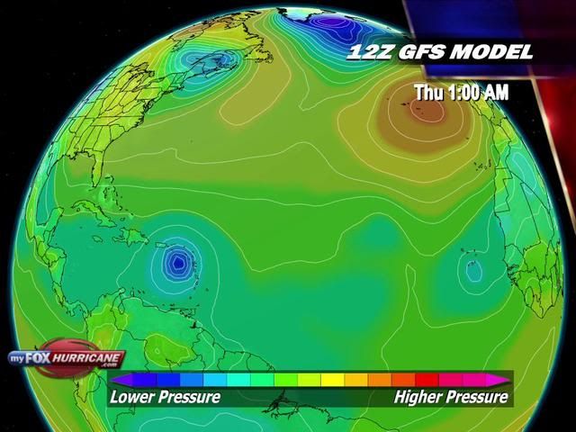
Als je niet gaat dan mag je mij die tickets wel gevenquote:Op donderdag 2 september 2010 15:25 schreef RodenCity het volgende:
[..]
Laten we hopen van niet, moet 12 september die kant uit vliegen. Dus mag van mij na die datum wel wat rustiger worden voor zeg 2.5 week.
Lijkt indd een grote te wordenquote:
Gaston lijkt groot te gaan worden in de Caraibische zee
[ afbeelding ]
Afwachten wat het allemaal gaat doen en aanrichten.
Weerstation Dokkum voor het actuele weer in de Friese 11steden stad
Doe mee met het voorspellen van het weer!
Weekvoorspelling | Maandvoorspelling Augustus - Invullen tot 31 juli 23:59 | Jaarvoorspelling 2026
Doe mee met het voorspellen van het weer!
Weekvoorspelling | Maandvoorspelling Augustus - Invullen tot 31 juli 23:59 | Jaarvoorspelling 2026

Heb ze vandaag opgehaald en zolang de piloot dat ding denkt te kunnen gaan landen daar, ga ik wel heen. Heb altijd al eens een orkaan mee willen makenquote:Op zaterdag 4 september 2010 10:26 schreef SpeedyGJ het volgende:
[..]
Als je niet gaat dan mag je mij die tickets wel geven
[..]
The Admirals......1995-2007
Volgens mij heeft dat gebied in de Golf meer kans dan (ex)Gaston. Al zal die in de Golf snel weer het land opgaan. Bij de kust van Afrika is ook weer kans op ontwikkeling.
[ Bericht 0% gewijzigd door #ANONIEM op 05-09-2010 15:58:04 ]
[ Bericht 0% gewijzigd door #ANONIEM op 05-09-2010 15:58:04 ]
Inmiddels is het gebied in de Golf uitgegroeid tot een tropische Depressie (ten).
De volgende naam is Hermine
[ Bericht 17% gewijzigd door #ANONIEM op 06-09-2010 08:26:45 ]
De volgende naam is Hermine
[ Bericht 17% gewijzigd door #ANONIEM op 06-09-2010 08:26:45 ]

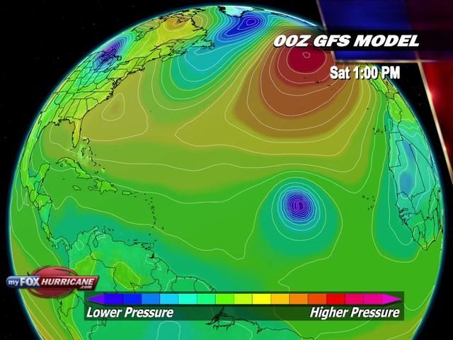
Gaat in een rap tempo, als dit zo doorgaat tot november zullen we Alpha en Beta weer uit de kast moeten gaan trekken.
Tropische storm Hermine ontstaan
Een tropische depressie in het zuidwestelijk gedeelte van de Golf van Mexico is maandag ochtend uitgegroeid tot een tropische storm. De tropische storm is de achtste van het orkaanseizoen van 2010 en heeft de naam Hermine gekregen. Hermine koerst naar de kust van Mexico en de Verenigde Staten en heeft momenteel windsnelheden van 65 kilometer per uur. De tropische storm lag maandagochtend ongeveer 375 kilometer ten zuidoosten van La Pesca, Mexico. De storm verplaatst zich noordwaarts met een snelheid van 13 kilometer per uur. Na alle verwachtingen zal Hermine dinsdagochtend aan land gaan ter hoogte van de noordoost hoek van Mexico of zuidelijke punt van Texas.
Bron: NASA - Hier een satellietopname van de tropische storm Hermine
Volgens het National Hurricane Center kan Hermine in het noordoosten van Mexico en in het zuidwesten van Texas grote hoeveelheden neerslag achter gaan laten die op kunnen lopen tot 200mm, in de afgelegen gebieden kan er zelfs een hoeveelheid van 300mm aan neerslag gaan vallen. Deze hoeveelheden regen kunnen levensbedreigende situaties tot het gevolg hebben. Overstromingen en modderlawines behoren tot de mogelijkheden in de hogere gelegen gebieden van noordoost Mexico. Momenteel is er een tropische storm waarschuwing van kracht voor de kust van Mexico van Tampico naar de Rio Grande en de kust van Zuid-Texas van de Rio Grande naar Baffin Bay.
Bron Weerdirect
Een tropische depressie in het zuidwestelijk gedeelte van de Golf van Mexico is maandag ochtend uitgegroeid tot een tropische storm. De tropische storm is de achtste van het orkaanseizoen van 2010 en heeft de naam Hermine gekregen. Hermine koerst naar de kust van Mexico en de Verenigde Staten en heeft momenteel windsnelheden van 65 kilometer per uur. De tropische storm lag maandagochtend ongeveer 375 kilometer ten zuidoosten van La Pesca, Mexico. De storm verplaatst zich noordwaarts met een snelheid van 13 kilometer per uur. Na alle verwachtingen zal Hermine dinsdagochtend aan land gaan ter hoogte van de noordoost hoek van Mexico of zuidelijke punt van Texas.

Bron: NASA - Hier een satellietopname van de tropische storm Hermine
Volgens het National Hurricane Center kan Hermine in het noordoosten van Mexico en in het zuidwesten van Texas grote hoeveelheden neerslag achter gaan laten die op kunnen lopen tot 200mm, in de afgelegen gebieden kan er zelfs een hoeveelheid van 300mm aan neerslag gaan vallen. Deze hoeveelheden regen kunnen levensbedreigende situaties tot het gevolg hebben. Overstromingen en modderlawines behoren tot de mogelijkheden in de hogere gelegen gebieden van noordoost Mexico. Momenteel is er een tropische storm waarschuwing van kracht voor de kust van Mexico van Tampico naar de Rio Grande en de kust van Zuid-Texas van de Rio Grande naar Baffin Bay.
Bron Weerdirect
Weer of geen weer, altijd actueel www.onweer-online.nl