WKN Weer, Klimaat en Natuurrampen
Lees alles over het onstuimige weer op onze planeet, volg orkanen en tornado's, zie hoe vulkanen uitbarsten en hoe Moeder Aarde beeft bij een aardbeving. Alles over de verwoestende kracht van onze planeet en tal van andere natuurverschijnselen.


De vorige deeltjes
[vulkanen] The ring of Fire
[Vulkanen] The ring of Fire #2:
In dit en komende topics, zal informatie gegeven worden over vulkanen door enthousiaste Fokkers!, en iedereen die wat weet over vulkanisme, mag hier z'n bijdrage erbij toevoegen.
Hoofdzakelijk zijn het de aardse vulkanen in belangstelling staan. Maar als er op een andere planeet/maan vulkanische aktieviteiten Zijn, dan mag het hier ook terzake komen.
De Aarde
Er zijn bergen, eilanden, en zeeën. En alles op een laag (aardkorst) van ongeveer 35 kilometer dikte.
De aardkorst
Al miljoenen jaren is de aardkost in beweging Door zijn aardbevingen, en er zijn vulkanen laat de aarde merken dat ie nog altijd actief is. De aardkorst bestaat niet uit één groot stuk maar uit een stuk of 9 grote en nog een aantal kleinere tektonische platen. Deze platen drijven op een vloeibare mantel.
En omdat die platen niet allemaal dezelfde kant opgaan. Komt het er op de plaatsen waar ze zich ontmoeten toe tot hevige botsingen. Op deze plekken kunnen zich ook de meeste vulkanenvormen.
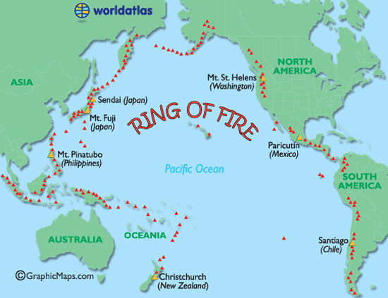
Ring of Fire
De Mantel
Soorten vulkanen
Er zijn 6 verschillende soorten vulkanen.
De spleetvulkaan
Een lange scheur in de aardkorst waardoor magma naar buiten komt. Deze ontstaat als twee tektonische platen uit elkaar drijven. Je vindt deze vooral bij oceaanruggen.
De schildvulkaan
Dit is een brede, ondiepe vulkaankegel, die ontstaat doordat het lava dat eruit stroomt, dun en heet is en heel langzaam afkoelt.
De koepelvulkaan
Deze kent een steile, bolle helling die gevormd is door dikke snel afkoelende lava.
De slakkenkegel
Een vulkaan die naast lava ook veel as uitspuugt. De berg die door deze vulkaan gevormd wordt, is dan ook opgebouwd uit lagen as en lava die elkaar afwisselen.
De samengestelde vulkaan
Deze is net zo opgebouwd als de slakkenkegel maar heeft naast de hoofdkrater nog meerdere kleinere kraters op haar flanken.
De calderavulkaan
Dit is een oudere vulkaan met aan de bovenkant een grote brede krater. In deze krater hebben zich weer kleinere nieuwe kraters gevormd.
Hotspots
Doordat een zeer hete brandhaard (hot-spot) in de mantel, door de aardkorst heen brandt.
Andere vormen van vulkanisme zijn de geisers en de hete bronnen. Die vind je vaak in de buurt van vulkanen waar de aardkorst dunner is en de warmte van het magma verder doordringt in de aardkorst. Een geiser is een holte in de aardkorst of een waterhoudende grondlaag, die door het onderliggende magma wordt verwarmd tot het kookpunt. Het water kan dan tot 500 meter in de lucht spuiten. Een hete bron werkt op dezelfde manier alleen wordt het water daar niet zo verhit, dat het onder druk van stoom eruit spuit.
Heeft Nederland een vulkaan?
Jazeker! De naam ervan is Zuidwalvulkaan, en ligt 17km ten westen van Harlingen
maar ... die is letterlijk allang dood en begraven. Deze ligt namelijk vele honderden meters onder de bodem van de huidige Waddenzee.
Links
BBC-How volcanoes work **NEW**
Global Volcanism Program
Volcano Discovery
Live Science - Volcanoes
37 Volcano Cams
Vulkanen.nl
Mediatheek - Vulkanen
vulkaan.startpagina.nl
Kennislink (Zuidwal vulkaan)
Vulkanen in de Eifel (Duitsland)
Planet-wissen [vulkanen](Duitstalig)
Verwante DE-topics
Krakatoa
Supervulkanen
Mount St.Helens
Supervolcano at Yellowstone Park
Deze OP in Fok!Wiki
Klik hier
[ Bericht 50% gewijzigd door Frutsel op 12-11-2007 08:45:53 ]
In dit en komende topics, zal informatie gegeven worden over vulkanen door enthousiaste Fokkers!, en iedereen die wat weet over vulkanisme, mag hier z'n bijdrage erbij toevoegen.
Hoofdzakelijk zijn het de aardse vulkanen in belangstelling staan. Maar als er op een andere planeet/maan vulkanische aktieviteiten Zijn, dan mag het hier ook terzake komen.
De Aarde
Er zijn bergen, eilanden, en zeeën. En alles op een laag (aardkorst) van ongeveer 35 kilometer dikte.
De aardkorst
Al miljoenen jaren is de aardkost in beweging Door zijn aardbevingen, en er zijn vulkanen laat de aarde merken dat ie nog altijd actief is. De aardkorst bestaat niet uit één groot stuk maar uit een stuk of 9 grote en nog een aantal kleinere tektonische platen. Deze platen drijven op een vloeibare mantel.
En omdat die platen niet allemaal dezelfde kant opgaan. Komt het er op de plaatsen waar ze zich ontmoeten toe tot hevige botsingen. Op deze plekken kunnen zich ook de meeste vulkanenvormen.
Ring of Fire
De Mantel


Soorten vulkanen
Er zijn 6 verschillende soorten vulkanen.
Een lange scheur in de aardkorst waardoor magma naar buiten komt. Deze ontstaat als twee tektonische platen uit elkaar drijven. Je vindt deze vooral bij oceaanruggen.
Dit is een brede, ondiepe vulkaankegel, die ontstaat doordat het lava dat eruit stroomt, dun en heet is en heel langzaam afkoelt.
Deze kent een steile, bolle helling die gevormd is door dikke snel afkoelende lava.
Een vulkaan die naast lava ook veel as uitspuugt. De berg die door deze vulkaan gevormd wordt, is dan ook opgebouwd uit lagen as en lava die elkaar afwisselen.
Deze is net zo opgebouwd als de slakkenkegel maar heeft naast de hoofdkrater nog meerdere kleinere kraters op haar flanken.
Dit is een oudere vulkaan met aan de bovenkant een grote brede krater. In deze krater hebben zich weer kleinere nieuwe kraters gevormd.
Doordat een zeer hete brandhaard (hot-spot) in de mantel, door de aardkorst heen brandt.
Andere vormen van vulkanisme zijn de geisers en de hete bronnen. Die vind je vaak in de buurt van vulkanen waar de aardkorst dunner is en de warmte van het magma verder doordringt in de aardkorst. Een geiser is een holte in de aardkorst of een waterhoudende grondlaag, die door het onderliggende magma wordt verwarmd tot het kookpunt. Het water kan dan tot 500 meter in de lucht spuiten. Een hete bron werkt op dezelfde manier alleen wordt het water daar niet zo verhit, dat het onder druk van stoom eruit spuit.
Heeft Nederland een vulkaan?
Jazeker! De naam ervan is Zuidwalvulkaan, en ligt 17km ten westen van Harlingen
maar ... die is letterlijk allang dood en begraven. Deze ligt namelijk vele honderden meters onder de bodem van de huidige Waddenzee.
Links
Verwante DE-topics
Deze OP in Fok!Wiki
[ Bericht 50% gewijzigd door Frutsel op 12-11-2007 08:45:53 ]
Het is in ieder geval het beste uitzicht wat ik die dag heb kunnen vinden, en volgens mij kan het niet veel beter op die afstand.quote:Op vrijdag 2 november 2007 13:06 schreef kahaarin het volgende:
[..]
Dan was mijn gevoel bij die foto toch goed.
Iig net hoog genoeg om een mooi uitzicht te verzorgen.
Ik zal eens neuzen op die link die je net hebt gepost. [afbeelding]
(Als je een spatie tussen de haakjes en de link zet, voor en achter de link, dat kun je erop klikken, nu moet je knippen en plakken.)
Ik heb al 2 van de 3 deeltjes in deze reeks geopend. Wie heeft de Wiki zo snel aangepast? Damn.. 
owh, dat was al eerder zo gedaan.
owh, dat was al eerder zo gedaan.
Status Mount Kelud 'critical': Crater lake warmer than before 1990 eruption
2 November 2007 16:10 (GMT+7) - Scientists at an observation post near the Mount Kelud volcano have told that the temperature of the crater lake has now reached 41.0° C, which is higher than the maximum temperature before it's last eruption in 1990, which then reached 40.0° C. The crater lake itself hasn't changed color yet, but there are increasing amounts of gases bubling to the surface.
2 November 2007 16:10 (GMT+7) - Scientists at an observation post near the Mount Kelud volcano have told that the temperature of the crater lake has now reached 41.0° C, which is higher than the maximum temperature before it's last eruption in 1990, which then reached 40.0° C. The crater lake itself hasn't changed color yet, but there are increasing amounts of gases bubling to the surface.
Free Assange! Hack the Planet
[b]Op dinsdag 6 januari 2009 19:59 schreef Papierversnipperaar het volgende:[/b]
De gevolgen van de argumenten van de anti-rook maffia
[b]Op dinsdag 6 januari 2009 19:59 schreef Papierversnipperaar het volgende:[/b]
De gevolgen van de argumenten van de anti-rook maffia

wat een ordinaire tvp!quote:
Op zaterdag 15 augustus 2009 23:05 schreef eer-ik het volgende:
Ik vind je sig nogal denigrerend.
Ik vind je sig nogal denigrerend.
quote:Op vrijdag 2 november 2007 13:39 schreef indahnesia.com het volgende:
[..]
kort maar krachtig, zoals de verwachte uitbarsting van de Kelud ook zal zijn
be nice or go away
verrekijker is beterquote:Op vrijdag 2 november 2007 13:48 schreef kahaarin het volgende:
[..]
[afbeelding] Kopje koffie erbij, nog beter! [afbeelding]
Vast niet veel te zien voor mij, beetje ver weg!quote:
Ik bedoelde natuurlijk bij het FOK! lezen, duh!
be nice or go away
owh dat kan natuurlijk ook. Vast wel iemand die foto's gaat maken en zoquote:Op vrijdag 2 november 2007 14:12 schreef kahaarin het volgende:
[..]
Vast niet veel te zien voor mij, beetje ver weg! [afbeelding]
Ik bedoelde natuurlijk bij het FOK! lezen, duh! [afbeelding]
Ja? Is het echt? Wie dan?quote:Op vrijdag 2 november 2007 14:14 schreef indahnesia.com het volgende:
[..]
owh dat kan natuurlijk ook. Vast wel iemand die foto's gaat maken en zo
Heb je nog een neiuw bericht over het kratermeer?
De meeste berichten die ik via google vind zijn niet echt recent te noemen, of ik zoek niet goed, kan ook.
be nice or go away
het laatste bericht staat in het Engels hier boven in het topic.quote:Op vrijdag 2 november 2007 14:28 schreef kahaarin het volgende:
[..]
Ja? Is het echt? Wie dan? [afbeelding]
Heb je nog een neiuw bericht over het kratermeer?
De meeste berichten die ik via google vind zijn niet echt recent te noemen, of ik zoek niet goed, kan ook. [afbeelding]
zou zomaar kunnenquote:Op vrijdag 2 november 2007 22:03 schreef Bakakame het volgende:
Ja ik las er vandaag ook over in de trein! [afbeelding]
Zit er nu echt aan te komen.. Dit weekend nog, of niet?
Uitbarsting Kelud zou begonnen zijn volgens lokale tv. Kut-weer en een kratermeer zorgen er echter voor dat er geen flikker te zien is, zo het schijnt.
Ik vertrek nog niet, het is net avond geworden. Op zijn vroegst morgenochtend.
Ik vertrek nog niet, het is net avond geworden. Op zijn vroegst morgenochtend.

Hoe warm is dat meer inmiddels?
Op zaterdag 15 augustus 2009 23:05 schreef eer-ik het volgende:
Ik vind je sig nogal denigrerend.
Ik vind je sig nogal denigrerend.

staat ie trouwens ergens op webcam? 
"We meet every day at the same cafe, six-thirty and no one knows she'll be there."
die zijn er niet, en al waren die er, dan was er nog niets te zien omdat het al dagen kut-weer is en blijft.quote:Op zondag 4 november 2007 09:56 schreef Adelante het volgende:
staat ie trouwens ergens op webcam? [afbeelding]
Kennis van me heeft de afgelopen weken meerdere malen dromen gehad over een fikse vulkaanuitbarsting. Bij het lezen van info over de Pinatubo zei ze dat het daar wel wat op leek, maar met meer lava die door de lucht vloog. Ik geloof niet in dergelijke 'helderziendheid', maar op de een of andere manier zit het wel in mijn achterhoofd en houdt het me tegen nu al te vertrekken, voor de uitbarsting dus.
google er maar eens opquote:Op zondag 4 november 2007 12:55 schreef Bakakame het volgende:
Ik weet er niets van, dus.. Hoe erg was de uitbarsting van de Pinatubo?
ik geloof dat de temperatuur als gevolg van afgenomen zonnekracht wereldwijd na 1 jaar met 1.0 graad celsius was gedaald, prima tegen het global warming proces natuurlijk.
"We meet every day at the same cafe, six-thirty and no one knows she'll be there."
Foto staat trouwens op de site 
http://news.indahnesia.com/event/53/mount_kelud_kelut_volcano.php
Het is weer donker, morgen zien we wellicht meer. Ondertussen lijkt het erop dat er nog niet voldoende kracht is om de lava-prop die tijdens de laatste uitbarsting in 1990 is ontstaan, te kunnen doorbreken. Tot op heden ontsnapt er alleen gas (en stoom van het kratermeer)
http://www.allheadlinenews.com/articles/7009050170
wel ja, flikker ze allemaal direct in de kraterquote:...
The volcano has been on high-level alert for the last two weeks but since last Friday, the volcano suddenly escalated, which triggered local officials to relocate residents to higher grounds.
...
die overige 70.000 zijn niet zo belangrijk?quote:According to health ministry, there were about 130,000 residents living within the danger zone area of Mt. Kelud, but government officials were just focusing to relocate only about 60,000 residents
"We meet every day at the same cafe, six-thirty and no one knows she'll be there."
in princiepe wil niemand weg, dus de mensen die ze weg krijgen zijn mooi meegenomen. De anderen staan op zichzelf na ruim twee weken proberen ze te evacueren.quote:Op maandag 5 november 2007 01:19 schreef Adelante het volgende:
[..]
die overige 70.000 zijn niet zo belangrijk?
Een beetje een snelkookpan idee dus.quote:Op maandag 5 november 2007 05:48 schreef indahnesia.com het volgende:
Temperatuur-meter van het kratermeer werkt niet meer, geschat wordt dat het meer 90° C is nu.
Naar idee dat er nog mensen zitten.
be nice or go away
er komt sinds deze middag kokend water over de rand van de krater de hellingen af. Het magma kan mogelijk met een geweldige explosie uit de vulkaan komen, maar dat is nog niet gebeurd tot op heden.
Nou als het kratermeer al zo warm is denk ik dat het wel snel gaat gebeuren.. Wanneer ging je ook weer, zei je?quote:Op maandag 5 november 2007 10:48 schreef indahnesia.com het volgende:
er komt sinds deze middag kokend water over de rand van de krater de hellingen af. Het magma kan mogelijk met een geweldige explosie uit de vulkaan komen, maar dat is nog niet gebeurd tot op heden.
Ik ga als de uitbarsting geweest is. Ze verwachten een behoorlijk explosieve uitbarsting. Op de een of andere manier heb ik het gevoel dat ik voorlopig maar niet te dichtbij moet komen.quote:Op maandag 5 november 2007 11:10 schreef Bakakame het volgende:
[..]
Nou als het kratermeer al zo warm is denk ik dat het wel snel gaat gebeuren.. Wanneer ging je ook weer, zei je?
Plan was eerder om bij het begin van de uitbarsting aan te reiden, en dat staat eigenlijk nog steeds. Maar de grote uitbarsting is nog niet gekomen, dus wacht ik lekker af en gaat mijn dagelijkse leventje gewoon door. Ik heb tot eind december, want dan vier ik nieuwjaar op Bali. Moet wel lukken dus.

Hoe ver woon jij er eigenlijk vanaf? Zit je wel helemaal veilig daar (v.w.b. deze vulkaan)?quote:Op maandag 5 november 2007 11:22 schreef indahnesia.com het volgende:
[..]
Ik ga als de uitbarsting geweest is. Ze verwachten een behoorlijk explosieve uitbarsting. Op de een of andere manier heb ik het gevoel dat ik voorlopig maar niet te dichtbij moet komen.
Plan was eerder om bij het begin van de uitbarsting aan te reiden, en dat staat eigenlijk nog steeds. Maar de grote uitbarsting is nog niet gekomen, dus wacht ik lekker af en gaat mijn dagelijkse leventje gewoon door. Ik heb tot eind december, want dan vier ik nieuwjaar op Bali. Moet wel lukken dus.
Op zaterdag 15 augustus 2009 23:05 schreef eer-ik het volgende:
Ik vind je sig nogal denigrerend.
Ik vind je sig nogal denigrerend.
Het is voor deze vulkaan wel veilig, hoewel... als het een Pinatubo wordt niet, maar dat zal wel meevallen. Ik zit op zo'n 250 kilometer hemelsbreed of zo.
Indonesian volcano building up awesome amount of energy: scientists
'awesome' klinkt toch steeds minder goed in mijn oren
[ Bericht 31% gewijzigd door indahnesia.com op 05-11-2007 12:14:28 ]
'awesome' klinkt toch steeds minder goed in mijn oren
[ Bericht 31% gewijzigd door indahnesia.com op 05-11-2007 12:14:28 ]
Zomaar ineens?quote:Op maandag 5 november 2007 12:15 schreef indahnesia.com het volgende:
Tering
Dan is de vulkaan wel erg bezig zeg...
Op zaterdag 15 augustus 2009 23:05 schreef eer-ik het volgende:
Ik vind je sig nogal denigrerend.
Ik vind je sig nogal denigrerend.
als het een krakatao wordt, maakt die 35km ook niet meer uitquote:Op maandag 5 november 2007 11:53 schreef indahnesia.com het volgende:
Het is voor deze vulkaan wel veilig, hoewel... als het een Pinatubo wordt niet, maar dat zal wel meevallen. Ik zit op zo'n 250 kilometer hemelsbreed of zo.
"We meet every day at the same cafe, six-thirty and no one knows she'll be there."

Dan zal je niet direct last hebben van een uitbarsting. Misschien dat je wel last krijgt van as ofzo.quote:Op maandag 5 november 2007 12:03 schreef indahnesia.com het volgende:
owh, hemelsbreed is het 215 km maar
Op zaterdag 15 augustus 2009 23:05 schreef eer-ik het volgende:
Ik vind je sig nogal denigrerend.
Ik vind je sig nogal denigrerend.
sinds vanmiddagquote:Op maandag 5 november 2007 12:18 schreef OA het volgende:
[..]
Zomaar ineens? [afbeelding]
Dan is de vulkaan wel erg bezig zeg...
quote:Op maandag 5 november 2007 12:18 schreef Adelante het volgende:
[..]
als het een krakatao wordt, maakt die 35km ook niet meer uit
Het 'maken' van Flevoland duurde geloof ik ook heel wat langer...quote:Op maandag 5 november 2007 12:24 schreef indahnesia.com het volgende:
[..]
sinds vanmiddagzo snel spuit Smit de eilanden niet op geloof ik
Op zaterdag 15 augustus 2009 23:05 schreef eer-ik het volgende:
Ik vind je sig nogal denigrerend.
Ik vind je sig nogal denigrerend.
neuh, zal ook wel meevallen inderdaad. Asval is wel mogelijk, maar dan moet het een beste uitbarsting zijn (zoeen als in 1919 van dezelfde vulkaan)quote:Op maandag 5 november 2007 12:19 schreef OA het volgende:
[..]
Dan zal je niet direct last hebben van een uitbarsting. Misschien dat je wel last krijgt van as ofzo.
Deze is dan wel 'maar' 100 meter in diameterquote:Op maandag 5 november 2007 12:27 schreef OA het volgende:
[..]
Het 'maken' van Flevoland duurde geloof ik ook heel wat langer... [afbeelding]
... maar ...
Hoe heet was de vulkaan ook weer bij vorige uitbarsting?quote:Op maandag 5 november 2007 12:27 schreef indahnesia.com het volgende:
[..]
neuh, zal ook wel meevallen inderdaad. Asval is wel mogelijk, maar dan moet het een beste uitbarsting zijn (zoeen als in 1919 van dezelfde vulkaan)
Hopelijk is de hitte van het meer geen rechtevenredige indicatie voor de kracht van de uitbarsting.
Iets zegt mij dat dat eilandje er niet heel lang gaat liggen.
be nice or go away
en wat was die in 1919?quote:Op maandag 5 november 2007 13:27 schreef indahnesia.com het volgende:
Er komt al kokend water over de kraterrand, 100° C dus zo'n beetje.
Kan die vulkaan dan ook van opzij gaan uitbarsten?quote:Op maandag 5 november 2007 14:48 schreef indahnesia.com het volgende:
[..]
geen idee, maar in 1990 kwam het niet voorbij de 40° C.
Het lijkt me dat die situatie een verschil in veilige zones kan opleveren.
Oh en dit:
Dat dikgedrukte gedeelte, kan dat ook komen doordat de instrumenten in de war zijn door de hitte of is er ondergronds het één en ander gebeurd?quote:"Increased underground magma movement has built up pressure on the blocked entrance, causing the bottom of the lake to rise and crack," said Saut Simatupang, an official at the Center for Volcanology and Geological and Hazard Mitigation. The deadly volcano has spewed clouds of steam and ash as high as 500 meters on Sunday, a day after confusion over whether the volcano had already started it's eruption. Officials at an observation post could not visually confirm an eruption, however instruments indicated so.[/
http://news.indahnesia.co(...)_from_its_crater.php
be nice or go away
Die instrumenten zijn ook maar machines. Als iemand iets verkeerd afleest, of iets vergelijkt met 'de vorige keer' of 'een andere vulkaan' dan kan dat wel eens fout gaan natuurlijk. Verder was er ook geen zicht dus, wat bij uitbarstingen - zeker in de vroege fase - handig is.
Ja, dat snap ik, maar als meerdere mensen de data aflezen als een indicatie voor een uitbarsting en die is er niet geweest dan zou je toch haast gaan denken dat er ondergronds het één en ander is gebeurd?quote:Op maandag 5 november 2007 15:00 schreef indahnesia.com het volgende:
Die instrumenten zijn ook maar machines. Als iemand iets verkeerd afleest, of iets vergelijkt met 'de vorige keer' of 'een andere vulkaan' dan kan dat wel eens fout gaan natuurlijk. Verder was er ook geen zicht dus, wat bij uitbarstingen - zeker in de vroege fase - handig is.
Is het nu veilig om aan te nemen dat deze uitbarsting nu al anders is dan andere?
Vanwege die hoge temperaturen in het kratermeer en as/stoom die nu dan wel uit de vulkaan komen?
Ik snap het niet meer zo goed, wta ik wel snap is dat men denkt dat de vorige uitbarsting heeft gezorgd voor een opstopping en dat de uitbarsting een hele hevige kan worden, maar de berg gedraagt zich, voor zover ik heb gelezen dan, anders dan bij vorige keren.
be nice or go away
ooh, maar er is zeker veel gaande onder de grond, dat is een gegeven feit en is nu bijna vn ver te ruiken en te zien.
Geen een uitbarsting is gelijk, echter soms wel gelijksoortig. Dat helpt mensen wel wat voorspellingen en verwachtingen te doen, maar ook dat gaat niet altijd goed.
De stoom die je nu ziet komt puur door het warme kratermeer inderdaad. Als het zo doorgaat is dat meer leeg. Dat is wel fijn, want dat scheelt weer in de hete modderstromen.
De lava van de vorige uitbarsting is gedeeltelijk hard geworden in de kraterpijp. Die prop (zie het als een bloedprop) wordt nu met geweld naar boven geduwd en zal als een kurk springen straks... de daadwerkelijke uitbarsting die nu verwacht wordt.
Het champagne effect?quote:Op maandag 5 november 2007 15:20 schreef indahnesia.com het volgende:
ooh, maar er is zeker veel gaande onder de grond, dat is een gegeven feit en is nu bijna vn ver te ruiken en te zien.
Geen een uitbarsting is gelijk, echter soms wel gelijksoortig. Dat helpt mensen wel wat voorspellingen en verwachtingen te doen, maar ook dat gaat niet altijd goed.
De stoom die je nu ziet komt puur door het warme kratermeer inderdaad. Als het zo doorgaat is dat meer leeg. Dat is wel fijn, want dat scheelt weer in de hete modderstromen.
De lava van de vorige uitbarsting is gedeeltelijk hard geworden in de kraterpijp. Die prop (zie het als een bloedprop) wordt nu met geweld naar boven geduwd en zal als een kurk springen straks... de daadwerkelijke uitbarsting die nu verwacht wordt.
Ik had gedacht dat elke vulkaan z'n eigen unieke uitbarstingen had, dat dacht ik te hebben begrepen uit een link die ik had gelezen, maar garanties voor in het verleden behaalde resultaten zijn ook voor vulkanen niet te geven dus.
be nice or go away
geen garanties inderdaad, hoewel het patroon wel gelijkend kan zijn. In dit geval gaat dat langzamerhand helemaal de mist in dus, maar dat was je wel duidelijk geloof ik
quote:Op maandag 5 november 2007 15:36 schreef indahnesia.com het volgende:
geen garanties inderdaad, hoewel het patroon wel gelijkend kan zijn. In dit geval gaat dat langzamerhand helemaal de mist in dus, maar dat was je wel duidelijk geloof ik
Is er meer bekend over of er nog steeds mensen weigeren van de berg te gaan?
Er is nu naar mijn bescheiden mening bewijs genoeg dat er een uitbarsting aan zit te komen, wat dat betreft is deze uitzonderingsreactie van Kelud misschien wel goed, ik kan me iig niet voorstellen dat er nu nog mensen zo naief kunnen zijn om te denken dat stil binnenzitten in het donker de berg kalm gaat houden.
be nice or go away
Mensen geloven erin dat als ze rustig aan doen er geen uitbarsting komt. Tja, dan kun je wel aankomen met gewapende politie, maar daar gaan ze toch niet in mee. Die zitten dus nog op de berghellingen 
Bah bah, je zou ze bijna aan hun haren ervandaan slepen, alleen jammer dat ze dan zodra de politie weer uit het kamp is ze waarschijnlijk dan linea recta weer naar huis gaan.quote:Op maandag 5 november 2007 15:57 schreef indahnesia.com het volgende:
Mensen geloven erin dat als ze rustig aan doen er geen uitbarsting komt. Tja, dan kun je wel aankomen met gewapende politie, maar daar gaan ze toch niet in mee. Die zitten dus nog op de berghellingen
Hopelijk valt het mee, er hoeft natuurlijk geen allesverwoestende uitbarsting te komen, ik ben er alleen wel bang voor.....
be nice or go away
Gisteren nog ff op google earth gekeken naar de Kelut.quote:Op dinsdag 6 november 2007 01:40 schreef indahnesia.com het volgende:
En tot op heden nog geen uitbarsting, ik kan dus weer aan een normale dag beginnen
Wat is nu de grootste stad daar in de buurt dan Indah?
Kediri naar het westen, Blitar in het zuiden en Batu in het noordoosten liggen vrij dichtbij en het zijn steden als Eindhoven en Utrecht. Ten oosten, maar verder naar het oosten dan Batu ligt Malang met iets van en half miljoen mensen.quote:Op dinsdag 6 november 2007 08:15 schreef Frutsel het volgende:
[..]
Gisteren nog ff op google earth gekeken naar de Kelut.
Wat is nu de grootste stad daar in de buurt dan Indah?
Plaatsen en afstanden t.o.v. Mount Kelud:
Pare: 22 km ten NW
Kediri: 35 km ten WNW
Batu: 25 km ten NO
Blitar: 21 km ten ZW
Malang: 35 km ten O
Surabaya: 85 km ten NO (miljoenenstad)
Mijn huis: 212 km ten WNW
Mooie statistiekjes voor in mijn website dus
Pare: 22 km ten NW
Kediri: 35 km ten WNW
Batu: 25 km ten NO
Blitar: 21 km ten ZW
Malang: 35 km ten O
Surabaya: 85 km ten NO (miljoenenstad)
Mijn huis: 212 km ten WNW
Mooie statistiekjes voor in mijn website dus
Dit is eigenlijk best wel gevaarlijk, ik vraag me af hoeveel mensen besluiten om toch maar weer terug te gaan, omdat het zo lang duurt, een paar weken terug zijn er al mensen uit hun huis gehaald omdat de berg op ontploffen stond.quote:Op dinsdag 6 november 2007 09:12 schreef indahnesia.com het volgende:
Plaatsen en afstanden t.o.v. Mount Kelud:
Pare: 22 km ten NW
Kediri: 35 km ten WNW
Batu: 25 km ten NO
Blitar: 21 km ten ZW
Malang: 35 km ten O
Surabaya: 85 km ten NO (miljoenenstad)
Mijn huis: 212 km ten WNW [ afbeelding ]
Mooie statistiekjes voor in mijn website dus [ afbeelding ]
be nice or go away
ze hadden het over een stad van ruim 300.000 inwoners toch, die direct gevaar liep?
zei jij dat niet? Welke was dat dan?
zei jij dat niet? Welke was dat dan?
Ik zit net te lezen over de Proto-Krakatau. Had echt geen idee dat de caldera zo belachelijk groot is geweest in de 6e eeuw
KLIK
KLIK
ja, dat was een mega-vulkaan (is nog, alleen weinig van te zien vooralsnogquote:Op dinsdag 6 november 2007 14:37 schreef Tokamak het volgende:
Ik zit net te lezen over de Proto-Krakatau. Had echt geen idee dat de caldera zo belachelijk groot is geweest in de 6e eeuw [afbeelding]
KLIK
Indah, had jij de OP WIKI aangepast? Misschien wat interessante links voor de OP
Soort gelijke vulkaan topics uit DE
Krakatau (de grootste vulkaanuitbarsting ooit)
Supervulkaan: Activiteit onder Yellowstone neemt toe
Mount St.Helens - Mei 1980 - Toen en Nu
(linkjes ff toegevoegd in de OP van dit deel)
Soort gelijke vulkaan topics uit DE
Krakatau (de grootste vulkaanuitbarsting ooit)
Supervulkaan: Activiteit onder Yellowstone neemt toe
Mount St.Helens - Mei 1980 - Toen en Nu
(linkjes ff toegevoegd in de OP van dit deel)
Ik heb de OP alleen voorzien van een linkje naar dit topic. Ik zal je drie links er ook bij zetten zodadelijk.quote:Op woensdag 7 november 2007 09:13 schreef Frutsel het volgende:
Indah, had jij de OP WIKI aangepast? Misschien wat interessante links voor de OP
Soort gelijke vulkaan topics uit DE
Krakatau (de grootste vulkaanuitbarsting ooit)
Supervulkaan: Activiteit onder Yellowstone neemt toe
Mount St.Helens - Mei 1980 - Toen en Nu
(linkjes ff toegevoegd in de OP van dit deel)
Thx, als je de OP in de wiki kan updaten, graag. Op naar deel vierquote:Op woensdag 7 november 2007 09:34 schreef indahnesia.com het volgende:
[..]
Ik heb de OP alleen voorzien van een linkje naar dit topic. Ik zal je drie links er ook bij zetten zodadelijk.
is gedaanquote:Op woensdag 7 november 2007 09:47 schreef Frutsel het volgende:
[..]
Thx, als je de OP in de wiki kan updaten, graag. Op naar deel vier [afbeelding]
Een zware bevalling dus...quote:KEDIRI, 07 November 2007 - The Mount Kelud volcano in eastern Java is still active. As is reported by reporters at the scene, the lava island inside the crater lake of the volcano is still growing. This is measured by the number of tremors originating from the crater. Clouds of white steam and smoke are still exhausted by the central part of the crater and reach altitudes of around 1,000 meters. The observation post for the Kelud volcano reported that there were 25 tremors inside the crater which caused the exhaust of white clouds of steam.
Wat zal er dan een kracht achter de uitbarsting gaan zitten als de kurk eindelijk eraf gaat.
be nice or go away
ja, daar word je wel een beetje bang voor als het zo lang duurtquote:Op woensdag 7 november 2007 13:00 schreef kahaarin het volgende:
[..]
Een zware bevalling dus...
Wat zal er dan een kracht achter de uitbarsting gaan zitten als de kurk eindelijk eraf gaat.
[b]Op maandag 6 september 2010 00:28 schreef tong80 het volgende:[/b]
GVD Wat moet jij een trotse vader zijn :)
:P
GVD Wat moet jij een trotse vader zijn :)
:P
Laat staan wat de bevolking doet als het zo lang duurt.quote:Op woensdag 7 november 2007 15:28 schreef Againzender het volgende:
[..]
ja, daar word je wel een beetje bang voor als het zo lang duurt
Beetje tot het laatste moment zorgen voor hun gewassen...
Binnen nu en ehhh een maand ZIJN dr geen gewassen meer!
Ik ben benieuwd hoe dat gaat de komende dagen..
I can only please one person per day. Today is not your day. Tomorrow isn't looking too good either.
quote:Op woensdag 7 november 2007 15:33 schreef Tokamak het volgende:
[..]
Laat staan wat de bevolking doet als het zo lang duurt.
Beetje tot het laatste moment zorgen voor hun gewassen...
Binnen nu en ehhh een maand ZIJN dr geen gewassen meer!
Kans op uitbarsting vulkaan op Java afgenomen
Het gevaar dat de vulkaan Kelud op het Indonesische eiland Java tot uitbarsting komt is zodanig verminderd dat duizenden geëvacueerde omwonenden mogen terugkeren naar hun huizen. Dat heeft de Indonesische vulkanologische dienst donderdag bekendgemaakt.
Er is weken gedacht dat de Kelud elk moment tot uitbarsting kon komen. Eind september al werd de evacuatie gelast van 24.000 omwonenden. Velen weigerden te vertrekken en werden onder dwang geëvacueerd, maar veel evacués gingen al snel weer terug naar huis. De bewoners van dorpen rond de vulkaan moeten volgens de autoriteiten wel waakzaam blijven, omdat de kans op een uitbarsting blijft bestaan. Omwonenden is aangeraden weg te blijven uit de buurt van de krater, die nog altijd rookt.
In 1919 vielen bij een uitbarsting van de Kelud meer dan vijfduizend doden. Volgens de overlevering was de uitbarsting honderden kilometers verderop te horen. In 1990 kostte een kleinere uitbarsting aan meer dan dertig mensen het leven.
jeps, het is allemaal tot nu toe meegevallen
de 'sleutelbewaarder' (spirituele beheerder van de vulkaan) zegt echter: "Er komt pas een uitbarsting als de mensen terug naar hun huizen gaan en de politie de posten verlaat."
Ze zei dit gisteren trouwens. Ik geloof er niet in, maar het wel toevallig dat precies een dag later de mensen terug mogen, niet?
en die mensen gaan ze natuurlijk niet voor een tweede keer wegkrijgen, "ja, want de eerste keer zijn we ook al voor niets geevacueerd"
"We meet every day at the same cafe, six-thirty and no one knows she'll be there."
jeps, en sommigen hebben al drie weken 'gezeten', wat ook niet echt bevorderlijk is geloof ik.quote:Op donderdag 8 november 2007 09:03 schreef Adelante het volgende:
en die mensen gaan ze natuurlijk niet voor een tweede keer wegkrijgen, "ja, want de eerste keer zijn we ook al voor niets geevacueerd" [afbeelding]
In een eerdere post had ik gelezen dan Kelud 'at the point of no return' zat,quote:Op donderdag 8 november 2007 09:10 schreef indahnesia.com het volgende:
[..]
jeps, en sommigen hebben al drie weken 'gezeten', wat ook niet echt bevorderlijk is geloof ik.
Dan is het ineens wel een 'reguliere' Kelud uitbarsting geworden, een soort van 'HAHA Fooled you' idee?
Ik zou toch niet graag op de helling van zo'n vulkaan willen wonen, alleen het idee al dat je alles zomaar kwijt kunt zijn als het ding het op z'n heupen krijgt.
be nice or go away
er komt zeker wel een uitbarsting, ooit. Een beetje hetzelfde verhaal met de 'big one' qua aardbevingen die ook zeker eens komt.
Maar daar staat tegenover dat de hellingen van vulkanen vaak heel vruchtbaar zijn, en er daarom vaak wel veel mensen wonen.quote:Op donderdag 8 november 2007 10:19 schreef kahaarin het volgende:
Ik zou toch niet graag op de helling van zo'n vulkaan willen wonen, alleen het idee al dat je alles zomaar kwijt kunt zijn als het ding het op z'n heupen krijgt.
Ik zou er liever ook niet wonen.
Ik hoop maar voor de mensen die in de omgeving daar wonen dat de vulkaan in ieder geval genoeg voortekenen gaat geven al shij echt uitbarst, en en zodoende nogmaals een evacuatie gehouden kan worden.
Tja, dit toont imho nog maar eens aan hoe weinig men eigenlijk weet van vulkanen en wat er nu precies onder de aardkorst gebeurt.quote:Op donderdag 8 november 2007 10:34 schreef indahnesia.com het volgende:
er komt zeker wel een uitbarsting, ooit. Een beetje hetzelfde verhaal met de 'big one' qua aardbevingen die ook zeker eens komt.
be nice or go away
mooi tochquote:Op donderdag 8 november 2007 10:43 schreef kahaarin het volgende:
[..]
Tja, dit toont imho nog maar eens aan hoe weinig men eigenlijk weet van vulkanen en wat er nu precies onder de aardkorst gebeurt.
"We meet every day at the same cafe, six-thirty and no one knows she'll be there."
quote:Op donderdag 8 november 2007 10:42 schreef Basp1 het volgende:
[..]
Maar daar staat tegenover dat de hellingen van vulkanen vaak heel vruchtbaar zijn, en er daarom vaak wel veel mensen wonen.
Ik zou er liever ook niet wonen.
Ik hoop maar voor de mensen die in de omgeving daar wonen dat de vulkaan in ieder geval genoeg voortekenen gaat geven al shij echt uitbarst, en en zodoende nogmaals een evacuatie gehouden kan worden.
Dit schreef Indahnesia.com een eindje hierboven, ik ben bang dat ook dan er een hoop mensen gewoon op hun erf blijven, het is erg jammer dat er niet met zekerheid gezegd kan worden of en wanneer die vulkaan gaat uitbarsten, hetgeen er nu is gebeurd kan er voor zorgen dat de volgende keer de mensen helemaal niet weg willen omdat men het al eerder fout had.quote:de 'sleutelbewaarder' (spirituele beheerder van de vulkaan) zegt echter: "Er komt pas een uitbarsting als de mensen terug naar hun huizen gaan en de politie de posten verlaat."
be nice or go away
quote:
Misschien eerst de aarde beter onderzoeken voor men aan het heelal begint, al die onderzoeken, satelieten en tripjes naar mars en weet ik veel waar terwijl men hele stukken oceaan en ook de vulkanen nog helemaal niet in kaart heeft.
[ Bericht 2% gewijzigd door kahaarin op 08-11-2007 11:10:20 ]
be nice or go away
precies, en toch maar naar de maan willenquote:Op donderdag 8 november 2007 10:43 schreef kahaarin het volgende:
[..]
Tja, dit toont imho nog maar eens aan hoe weinig men eigenlijk weet van vulkanen en wat er nu precies onder de aardkorst gebeurt.
ik woon op hemelsbreed 25 kilometer van de krater van de Merapi.quote:Op donderdag 8 november 2007 10:42 schreef Basp1 het volgende:
[..]
Maar daar staat tegenover dat de hellingen van vulkanen vaak heel vruchtbaar zijn, en er daarom vaak wel veel mensen wonen.
Ik zou er liever ook niet wonen.
Ik hoop maar voor de mensen die in de omgeving daar wonen dat de vulkaan in ieder geval genoeg voortekenen gaat geven al shij echt uitbarst, en en zodoende nogmaals een evacuatie gehouden kan worden.
25 km, dat is toch wel redelijk uit de directe gevaren zone?quote:Op donderdag 8 november 2007 11:05 schreef indahnesia.com het volgende:
[..]
precies, en toch maar naar de maan willen
[..]
ik woon op hemelsbreed 25 kilometer van de krater van de Merapi.
As en overstroming misschien daargelaten?
De mensen die direct op de flank van een vulkaan wonen zijn toch heel wat kwetsbaarde toch?
be nice or go away
Als er maar genoeg as valt zullen er verder van de vulkaan ook flink wat huizen instorten, een laag as heeft een flink gewicht en daarop zijn huizen niet berekend.quote:Op donderdag 8 november 2007 11:31 schreef kahaarin het volgende:
[..]
25 km, dat is toch wel redelijk uit de directe gevaren zone?
As en overstroming misschien daargelaten?
De mensen die direct op de flank van een vulkaan wonen zijn toch heel wat kwetsbaarde toch?
Pinatubo lag rond de 20 km van clark airbase , hier zijn ook nog verschillende gebouwen ingestort vanwegen de as regens.
http://nl.wikipedia.org/wiki/Mount_Pinatubo
ja, die is 5 kilometer voor deze vulkaan. As kan uiteraard wel, en overstromingen ook, al gaan die meestal richting het westen en oosten. Geen garanties, ook hier nietquote:Op donderdag 8 november 2007 11:31 schreef kahaarin het volgende:
[..]
25 km, dat is toch wel redelijk uit de directe gevaren zone?
As en overstroming misschien daargelaten?
De mensen die direct op de flank van een vulkaan wonen zijn toch heel wat kwetsbaarde toch?
quote:Op donderdag 8 november 2007 12:04 schreef Basp1 het volgende:
[..]
Als er maar genoeg as valt zullen er verder van de vulkaan ook flink wat huizen instorten, een laag as heeft een flink gewicht en daarop zijn huizen niet berekend.
Pinatubo lag rond de 20 km van clark airbase , hier zijn ook nog verschillende gebouwen ingestort vanwegen de as regens.
http://nl.wikipedia.org/wiki/Mount_Pinatubo
Nog verder weg zelfs!quote:De Verenigde Staten hadden twee grote luchtmachtbasissen in deze regio ten tijde van de uitbarsting; Subic Bay Naval Base lag 75 kilometer ten zuidwesten van de vulkaan, terwijl Clark Air Base op een kleine 40 kilometer ten oosten van de vulkaan lag. Beide basissen werden verlaten nadat ze ernstig beschadigd werden tijdens de uitbarsting.
Gevonden onder het kopje nasleep, het betreft hier wel schade door natte as en er was ook sprake van noodweer, ik weet niet wat er was gebeurd als het was gebeurd bij gewoon weer, bij directe gevaren zone bedoel ik eigenlijk bedreiging door lava, brandend gas en lahars.
Hij zal niet direct in levensgevaar zijn als de vulkaan uitbarst en hoogstwaarschijnlijk ook niet in huis blijven zitten als er zo'n uitbarsting is geweest, denk ik.
Hij wilde ook al foto's gaan maken van Mount Kelud, een uitbarsting in de achtertuin zal hij dan ook niet aan zijn neus voorbij laten gaan.
be nice or go away
In geval van uitbarsting ben je toch ook helemaal niet in huis?quote:Op donderdag 8 november 2007 12:09 schreef indahnesia.com het volgende:
[..]
ja, die is 5 kilometer voor deze vulkaan. As kan uiteraard wel, en overstromingen ook, al gaan die meestal richting het westen en oosten. Geen garanties, ook hier niet
Dan ga je toch foto's maken?
be nice or go away
ook dat nog eens inderdaad, tenzij ik lig te pitten en dat ding ineens explosief wordt.. tja...quote:Op donderdag 8 november 2007 12:16 schreef kahaarin het volgende:
[..]
In geval van uitbarsting ben je toch ook helemaal niet in huis?
Dan ga je toch foto's maken? [afbeelding]
Anak Krakatau erupts
Anak Krakatau, built on the same lava plume as the Krakatoa volcano that killed tens of thousands in 1883, continued to spew lava, hot gas and rocks Thursday into the Sunda Strait between the Indonesian islands of Java and Sumatra.
Anak Krakatua, or "Child of Krakatoa" in the official Indonesian language, rose from the water in 1930 at the same spot where Krakatoa had blown itself apart.
Elsewhere in Indonesia, the government lowered the alert status of the Kelud volcano, meaning that thousands of people who fled its slopes for government shelters can return home.
Mount Kelud on the densely populated island of Java had been on top alert for several weeks.
"The volcano no longer has the energy needed for an explosive eruption that would threaten the lives of people living nearby," Surono, the chief volcanologist at the government's volcano agency, said on the decision to downgrade Kelud's status.
Like many Javanese, Surono uses a single name.
In 1990, Kelud spewed searing fumes and lava that killed more than 30 people and injured hundreds. In 1919, a powerful explosion that reportedly could be heard hundreds of miles away killed at least 5,160.
Thousands of people from villages close to Kelud's crater lake had earlier heeded evacuation orders and moved to tent camps or government buildings, though many ignored the warnings and remained in the danger zone.
The government volcano agency said Kelud remained on the second-highest alert level and told villagers to remain vigilant because the mountain was very unpredictable. It said that villagers could return home, but should not venture close to the crater, which was still emitting smoke.
Indonesia is prone to volcanic eruptions and earthquakes because of its location on the so-called "Ring of Fire" — a series of fault lines stretching from the Western Hemisphere through Japan and Southeast Asia.


Wel frappant.. iedereen op z'n hoede voor Kelud en die lijkt net weer veilig en prompt gaat de Krakatau 
Ik heb helemaal niets gezien als 'aankondiging' voor de Krakatau, kwam dit nou zo onverwachts?
Ik heb helemaal niets gezien als 'aankondiging' voor de Krakatau, kwam dit nou zo onverwachts?
I can only please one person per day. Today is not your day. Tomorrow isn't looking too good either.
Het was wel bekend dat hij actief was, maar dat heeft volgensmij het grote nieuws niet echt gehaald. Denk dat de Kelud het nieuws wat dat betreft een beetje te veel heeft overheerst.quote:Op donderdag 8 november 2007 19:54 schreef E.T. het volgende:
Wel frappant.. iedereen op z'n hoede voor Kelud en die lijkt net weer veilig en prompt gaat de Krakatau
Ik heb helemaal niets gezien als 'aankondiging' voor de Krakatau, kwam dit nou zo onverwachts?
De Krakatau is altijd redelijk actief. Enkele dagen geleden kwam er ineens een neuwe krater te voorschijn, en toen issie actiever geworden.
`Was dit niet die vulkaan waarvan ze een docu hadden gemaakt. Dat als deze zou uitbarsten dat er een deel kon afbreken en in de zee kon zakken waardoor er een enorme vloedgolf zou ontstaan?
Nothing is worth doing unless the consequences may be serious!
Iets anders, niets alarmerends maar misschien wel interressant voor de geinteresseerden...
Op de science sectie van news.yahoo.com staat een berichtje van Asociated Press met de titel
Ground said rising at Yellowstone Park
Mijn gedachte: Er zijn hier vast wel mensen die dat soort berichten volgen, dus maar even tippen.
Op de science sectie van news.yahoo.com staat een berichtje van Asociated Press met de titel
Ground said rising at Yellowstone Park
Mijn gedachte: Er zijn hier vast wel mensen die dat soort berichten volgen, dus maar even tippen.
Huidige trend atmosf. CO2 Mauna Loa: 411 ppm ,10 jaar geleden: 387 ppm , 25 jaar geleden: 358 ppm
Yep, maar vers van de pers is vers van de persquote:Op vrijdag 9 november 2007 01:51 schreef indahnesia.com het volgende:
Dat van die Gele Steen is volgens mij altijd al aan de gang? Het is immers een vulkaan idd.
Huidige trend atmosf. CO2 Mauna Loa: 411 ppm ,10 jaar geleden: 387 ppm , 25 jaar geleden: 358 ppm
moah, ik kom van de Kelud inmiddels ook berichten tegen die 4 keer zijn herhaald sinds 16 oktober Steeds hetzelfde verhaaltje van gedwongen evacuatie. Maar inmidddels mag men weer terug. 
Ook de ijen-vulkaan (oostelijk Java) is actief geworden:
http://www.metrotvnews.com/berita.asp?id=48731
Bericht wordt nog vertaald op dit moment
http://www.metrotvnews.com/berita.asp?id=48731
Bericht wordt nog vertaald op dit moment
Hoogstws betekent het niets (bijzonders). Zoals Indahnesia al zei, Yellow is constant in beweging. De meting is pas zo'n 80 jaar aan de gang. in de 600.000 jaar oude huidige Yellowstone zal dit waarschijnlijk niet meer zijn dan een 'boertje'. Echter, een kleine eruptie is ook niet uitgesloten. Als je over een hele lange periode zou kijken, zou Yellowstone op en neer gaan als een soort van hartritme. Hoogstws niets waar je je druk over hoeft te maken dus.quote:Op vrijdag 9 november 2007 01:41 schreef barthol het volgende:
Iets anders, niets alarmerends maar misschien wel interressant voor de geinteresseerden...
Op de science sectie van news.yahoo.com staat een berichtje van Asociated Press met de titel
Ground said rising at Yellowstone Park
Mijn gedachte: Er zijn hier vast wel mensen die dat soort berichten volgen, dus maar even tippen.
In mijn schooltijd (goede oude tijd ) waren er ook al regelmatig van zulke berichten over Yellowstone.
Ik weet nog dat we het er over gehad hebben bij Aardrijkskunde destijds En dat is uchtuch-jaar geleden
Ik weet nog dat we het er over gehad hebben bij Aardrijkskunde destijds
I can only please one person per day. Today is not your day. Tomorrow isn't looking too good either.
Nee, dat zou een van de canarsiche eilanden zijn.quote:Op vrijdag 9 november 2007 00:55 schreef PhoeniXProjects het volgende:
`Was dit niet die vulkaan waarvan ze een docu hadden gemaakt. Dat als deze zou uitbarsten dat er een deel kon afbreken en in de zee kon zakken waardoor er een enorme vloedgolf zou ontstaan?
http://www.dossierx.nl/content/view/214/61/
Klopt en ook daar loopt een heel topic overquote:Op vrijdag 9 november 2007 12:45 schreef Basp1 het volgende:
[..]
Nee, dat zou een van de canarsiche eilanden zijn.
http://www.dossierx.nl/content/view/214/61/
Mega tsunami door in zee vallen van eiland La Palma?
Owh, nog een boeiend topicquote:Op vrijdag 9 november 2007 12:52 schreef Frutsel het volgende:
[..]
Klopt en ook daar loopt een heel topic over [afbeelding]
Mega tsunami door in zee vallen van eiland La Palma?
Vulkanen! 
"It's hard to argue against cynics - they always sound smarter than optimists because they have so much evidence on their side."
vast wel een keer, maar het is niet meer zo direct als eerst gevreesd/gedacht.quote:Op zondag 11 november 2007 14:36 schreef Bakakame het volgende:
Hoe zit het nu met Kelud? Gebeurt niks meer mee (denken ze)?
Klopt, ook daar loopt een topic overquote:Op vrijdag 9 november 2007 01:41 schreef barthol het volgende:
Iets anders, niets alarmerends maar misschien wel interressant voor de geinteresseerden...
Op de science sectie van news.yahoo.com staat een berichtje van Asociated Press met de titel
Ground said rising at Yellowstone Park
Mijn gedachte: Er zijn hier vast wel mensen die dat soort berichten volgen, dus maar even tippen.
interessant om te lezen
Mijn usericon is mede mogelijk gemaakt door wonderer.
Live from Sparta MO
JOE-ES-EE!!
Live from Sparta MO
JOE-ES-EE!!
daar ook maar even een tvp-tje geplaatst.
Hier is het weer zoals voorheen. Rommelende vulkanen en daar blijft het bij.
Hier is het weer zoals voorheen. Rommelende vulkanen en daar blijft het bij.
*Eindelijk weer verbinding heeft*quote:Op dinsdag 13 november 2007 08:29 schreef indahnesia.com het volgende:
daar ook maar even een tvp-tje geplaatst.
Hier is het weer zoals voorheen. Rommelende vulkanen en daar blijft het bij.
Die stomme bergen sussen iedereen in slaap en gaan dan als ze weer tot de orde van de dag zijn overgegaan dan gaan ze rellen.
be nice or go away
Die aardbevingen bij Raba en Labuhanbajo zijn allemaal net ten oosten van de Tambora vulkaan. Nu is deze vrijwel niet actief, maar zit er wat aan te komen?
Date Magn. Location Long. Lat.
2007-11-26 10:31:58 WITA 5.6 41km N.W. of Raba 118.700 -8.100
2007-11-26 09:56:55 WITA 5.1 62 km S.W. of Labuhanbajo 119.350 -8.670
2007-11-26 05:44:59 WITA 5.0 93 km N.W. of Raba 118.740 -7.630
2007-11-25 19:53:10 UTC 6.8 48 kmN.W. of Raba 118.520 -8.110
2007-11-25 17:41:37 UTC 6.0 107 km N.W. of Mukomuko 100.180 -2.360
2007-11-25 17:15:10 UTC 5.0 44 km N.W. of Raba 118.480 -8.180
2007-11-25 16:52:50 UTC 4.9 66 km S. of Raba 118.550 -9.030
2007-11-26 00:02:20 WITA 6.7 50 km N.W. of Raba 118.350 -8.270
2007-11-25 17:07:55 WIB 5.6 164 km S.W. of Bengkulu 101.870 -5.220
http://indahnesia.com/earthquake/2/last_24_hours.php
Dit las ik op de site van Jan Visser
quote:mogelijk een vulkaanuitbarsting op IJsland
Sinds afgelopen vrijdag zijn honderden kleine aardbevingen geregistreerd in de IJslandse regio Upptyppingar. Dat gebied is gesitueerd ten oosten van de beroemde vulkaan Askja en ten noorden van Europa's grootste gletsjer de Vatnajökull. De meeste bevingen zijn waargenomen op een diepte van 13-15 kilometer maar wanneer ze dichter aan het aardoppervlak komen, is er kans op een vulkaanuitbarsting. Dit zegt Sigthrudur van de Icelandic Meteorological Office.
Het gebied ten noorden van de Vatnajökull gletsjer is vulkanisch actief maar de laatste keer dat daar een eruptie heeft plaatsgevonden is 1000 jaar geleden. De Askja kwam voor het laatst tot uitbarsting in 1961.
Hier is alles vrijwel rustig.Dat heeft me mooi de gelegenheid om lekker op vakantie te gaan volgende week.
Je roept het wel een beetje af zo, Kelud is toch van de onverwachte uitbarstingen?quote:Op donderdag 20 december 2007 12:43 schreef indahnesia.com het volgende:
Hier is alles vrijwel rustig.Dat heeft me mooi de gelegenheid om lekker op vakantie te gaan volgende week.
Edit: En prettige vakantie natuurlijk!
be nice or go away
Als ik op Bali ben ga ik NIET terug voor een uitbarsting. Forget it.. die villa met zwembad laat ik niet schietenquote:Op donderdag 20 december 2007 13:17 schreef kahaarin het volgende:
[..]
Je roept het wel een beetje af zo, Kelud is toch van de onverwachte uitbarstingen? [afbeelding]
Edit: En prettige vakantie natuurlijk! [afbeelding]
Dat had ik begrepen, daarom ook prettige vankantie natuurlijk!quote:Op donderdag 20 december 2007 13:30 schreef indahnesia.com het volgende:
[..]
Als ik op Bali ben ga ik NIET terug voor een uitbarsting. Forget it.. die villa met zwembad laat ik niet schieten
Villa met zwembad, klinkt goed, lekker ontspannen en bijtanken!
be nice or go away
Ja, inderdaad... dat zou de eerste ontspannen week zijn in een jaar tijd eigenlijk.. maar goed, alles is relatief natuurlijk. Internet gaat wel mee bijvoorbeeld, dus daar gaat het eigenlijk al fout.quote:Op donderdag 20 december 2007 13:50 schreef kahaarin het volgende:
[..]
Dat had ik begrepen, daarom ook prettige vankantie natuurlijk! [afbeelding]
Villa met zwembad, klinkt goed, lekker ontspannen en bijtanken! [afbeelding]
Natuurlijk niet, naast het zwembad, op een ligstoel, ice-tea erbij en i-netten afwisselen met af en toe een frisse duik, lijkt me heerlijk!quote:Op donderdag 20 december 2007 14:00 schreef indahnesia.com het volgende:
[..]
Ja, inderdaad... dat zou de eerste ontspannen week zijn in een jaar tijd eigenlijk.. maar goed, alles is relatief natuurlijk. Internet gaat wel mee bijvoorbeeld, dus daar gaat het eigenlijk al fout.
be nice or go away
supervolcano avond op discovery
"We meet every day at the same cafe, six-thirty and no one knows she'll be there."

SANTIAGO, Chile — A volcano in southern Chile erupted on Tuesday, spewing lava and ash, and forcing the evacuation of about 150 people, officials said.
Authorities declared an "early alert" around the Llaima volcano, readying police and firefighters in case further evacuations were needed, Chile's Emergency Bureau said in a communique.
A column of smoke rose more than 9,300 feet into the sky and television images showed thick smoke and lava emerging from Llaima, one of the most active of the dozens of volcanos in Chile.
Emergency bureau director Carmen Fernandez said 150 tourists and National Forest Service employees were evacuated from the Conguillio National Park where the volcano is located, 400 miles south of Santiago.
If necessary, residents could also be evacuated from Melipeuco, a town of at least 5,000 located 8 miles from the volcano, officials said.
Bureau officials and vulcanologists were flying over the volcano to monitor the situation.
The 9,400-foot volcano last erupted in May, but has not suffered a major blast since 1994.
Goh, even volgen dit, 6,1 richterschaal is geen kleintje.quote:Griekenland getroffen door zware aardbeving
Uitgegeven: 6 januari 2008 07:27
ATHENE - Griekenland is zondagochtend opgeschrikt door een krachtige aardbeving. De schok had een kracht van 6,1 op de schaal van Richter, aldus het Amerikaanse seismologische centrum USGS.
Het epicentrum lag 124 kilometer ten zuidwesten van de hoofdstad Athene, waar inwoners door de beving uit hun slaap werden gewekt. Er zijn nog geen berichten van schade of slachtoffers.
Kracht
Het centrum sprak in eerste instantie van een beving met een kracht van 6,5. De aardschok vond plaats om 7.15 uur (6.15 uur Nederlandse tijd), ongeveer 75 kilometer onder de aardbodem van het schiereiland Peloponnesos.
Europa
Van alle aardbevingen in Europa vindt de helft in Griekenland plaats. In september 1999 leidde een aardbeving met een kracht van 5,9 in Athene en omgeving tot de dood van ruim 140 mensen. Ongeveer 60.000 inwoners raakten dakloos.
be nice or go away
RTL meldt de bijna uitbarsting van de Tungurahua. Een vulkaan die wel vaker uitbarst. Vorig jaar in Ecuador nog rokend gezien tussen 2 uitbarstingen in waarvan 1 een aantal doden tot gevolg had. En dorpen op de flanken plat door lavastromen. Heel apart om te zien.
Bron
Bron
Kein gewalt! Wir sind das volk!
Steps taken forwards but sleepwalking back again.
''And the Germans kill the Jews, And the Jews kill the Arabs, And the Arabs kill the hostages
And that is the news.''
Steps taken forwards but sleepwalking back again.
''And the Germans kill the Jews, And the Jews kill the Arabs, And the Arabs kill the hostages
And that is the news.''
Vulkaanuitbarsting in Colombia
BOGOTA - De vulkaan Galeras, in de stad Pasto ten zuidwesten van Colombia, is donderdagavond uitgebarsten. Zo’n 8000 inwoners werden geëvacueerd.
’Het protocol voorziet in de evacuatie van de inwoners in de bedreigde zone. Zij worden naar veiligere oorden gebracht’, verklaarde de regeringssecretaris van het departement Narino. De uitbarsting heeft vond plaats rond 20.06 uur lokale tijd. De bedreigde zone omvat de regio rond Pasto en de dorpen Sandona, Narino, Yacuanquer, Consaca en Genoy.
De 4.276 meter hoge vulkaan bevindt zich in het bergachtige gebied van de Andes. Hij is opnieuw actief sinds 2004. De laatste uitbarstingen dateren van 1992 en 1993.

quote:Thousands flee volcanic eruption in Colombia
Bron : CNN
(CNN) -- A volcano erupted in southwestern Colombia on Thursday night, prompting authorities to order the evacuation of about 8,000 people.
This video frame released by the Colombian Institute of Geology and Mining shows the eruption.
Images broadcast on Caracol, a Colombian television station, showed white smoke pouring into the evening sky from a mountain with a summit of 14,029 feet (4,276 meters).
Authorities canceled Friday classes in schools around the Galeras volcano, Caracol reported.
The Galeras volcano is one of the most active in Colombia.
The Volcanic Ash Advisory Center in Washington, which tracks eruptions in a region that includes Colombia, said early Friday that an "explosive eruption" had taken place.
Fernando Gil, director of Colombia's Seismological Network, told The Associated Press by phone it was the volcano's most severe eruption since it reactivated in 1989.
"Depending on the wind direction it's going to spread ashes over the entire area," he told the AP, adding that "most of [Galeras'] eruptions are violent and short."
Activity at the volcano also prompted an evacuation in November 2005, and a 1993 eruption killed a group of scientists working nearby.

Kunnen ze weer een hoop mooie foto's voor in boekjes schieten
Machtig mooi om te zien
Machtig mooi om te zien
Ik denk meer dat je als nieuwsposter een geile egocentrische narcist moet zijn, die een flinke stijve krijgt van alle berichten die ie van zijn eigen hand ziet op de FP, zo! ©yvonne
Beste nieuwsbericht ooit op de FOK!frontpage!
Beste nieuwsbericht ooit op de FOK!frontpage!
Ancient Antarctic eruption noted
Scientists have found what they say is the first evidence of a volcanic eruption under the Antarctic ice sheet.
They believe the volcano erupted about 2,000 years ago, and would have burst through its ice covering, producing a burst of steam and rocky debris.
The British Antarctic Survey (Bas) scientists report their finding in the journal Nature Geoscience.
They say it could aid understanding of an ice mass which is likely to play a key role in climate change.
The researchers discovered the eruption's traces by analysing radar data collected during an airborne survey of the area in 2004/5.
It showed a layer of volcanic ash - highly reflective to radar - that had been deposited on the ice surface and subsequently buried under successive years of snow in what are now the Hudson Mountains.
In the middle of the area, the rock underneath the ice rises up in the shape of a mountain as much as 1km high.
The thickness of ice above suggests the eruption occurred just over 2,200 years ago.
"The discovery of a 'subglacial' volcanic eruption from beneath the Antarctic ice sheet is unique in itself," said Bas's Hugh Corr, lead author on the scientific paper.
"We believe this was the biggest eruption in Antarctica during the last 10,000 years. It blew a substantial hole in the ice sheet, and generated a plume of ash and gas that rose about 12km into the air."
====
Rest van het artikel ---> http://news.bbc.co.uk/1/hi/sci/tech/7194579.stm
QUITO, Ecuador — Ecuador's Tungurahua volcano shot columns of ash miles into the air on Wednesday, as officials ordered the evacuation of 3,000 villagers living near its slopes.
Some 1,000 villagers from the western flanks of the 16,575-foot volcano fled their homes for shelters at dawn, said Mauro Rodriguez, director of Civil Defense.
He said 11 families who refused to leave, fearing looters, were removed by force.
"We've taken all of the precautions possible," President Rafael Correa told reporters on Wednesday, adding that a state of emergency already in place in the area will be extended for 60 days.
Juan Salazar, the mayor of the nearby village of Penipe, said 3,000 people needed to be evacuated ,a figure that included the 1,000 villagers who had already fled
Experts at the Geophysics Institute warn that the intense activity shows no sign of slowing down, and compared it to the massive 2006 Tungurahua eruptions that buried entire villages, leaving at least four dead and thousands homeless.
"The volcano has entered a new explosive eruption cycle, a process which does not seem to be slowing down," said Hugo Yepez, director of the Geophysics Institute.
The institute said Wednesday's eruptions shot ash six miles into the air.
Populations on Tungurahua's western flank have been most affected, particularly the communities of Bilbao, Cusua, Chacauco and Puela. The popular tourist town of Banos near the volcano, is currently not at risk.
There were no reported victims, according to Roberto Rodriguez, the Civil Defense director.
Ash billowing from Tungurahua, whose name means "throat of fire" in the local indigenous Quichua language, has already covered thousands of acres of farmland, destroying property, crops and livestock.
Tungurahua, located 95 miles southeast of the capital of Quito, has been active since 1999.
Separately, a volcano in southern Chile that erupted the first day of the year has resumed "permanent eruptive activity" but it poses no immediate danger to any populated area, authorities said.
"The volume of lava emission is very small and it has reached only some 4,900 feet from the crater" of the Llaima volcano, said Juan Cayupi, a vulcanologist with the Emergency Bureau. Llaima volcano lies 400 miles south of Santiago.


iemand beelden van die vulkaan die nu op Hawaii uitbarst?
"We meet every day at the same cafe, six-thirty and no one knows she'll be there."
Hier staan beelden:quote:Op zaterdag 8 maart 2008 00:11 schreef Adelante het volgende:
iemand beelden van die vulkaan die nu op Hawaii uitbarst?
http://www.faz.net/s/Rub0(...)pl~Ecommon~SMed.html
Op zaterdag 15 augustus 2009 23:05 schreef eer-ik het volgende:
Ik vind je sig nogal denigrerend.
Ik vind je sig nogal denigrerend.
Vulkaan roert zich in Hawaï
In Hawaï vergapen bezoekers zich, ondanks explosies en giftige gassen, aan de spectaculaire eruptie van de Kilaueavulkaan.
De afgelopen maanden kreeg het Hawaï Volcanoes National Park zo'n 9.000 bezoekers per dag over de vloer, een fikse stijging tegenover verleden jaar, toen de vulkaan zich rustiger hield.
Rookpluimen
In het park kunnen bezoekers de rookpluimen van as en solferdioxide zien die boven de Halemaumaukrater uitrijzen. De vulkaan spuwt lava. Verleden week vonden flinke gasexplosies plaats, allemaal bij de eerste uitbarsting van de hoofdkrater van de Kilauea sinds 1924.
Lava in de oceaan
Buiten het park, langs de zuidoostelijke kust van Big Island komen tot 10.000 mensen per dag om tot te kijken hoe de naar omlaag rollende lava in aanraking komt met het oceaanwater, wat voor gigantische stoomwolken zorgt.
Voorbereid
Er worden voorbereidingen getroffen om de zone te evacueren, mocht de wind van richting veranderen. Maar een grote uitbarsting van de vulkaan wordt niet verwacht, aangezien er zich geen lava in de caldera zelf bevindt.
Passaatwinden
''Zolang de passaatwinden in dezelfde richting blijven blazen, is er niet veel gevaar'', zeggen de autoriteiten. Het nationale park blijft dan (voorlopig) ook open.


Op zaterdag 15 augustus 2009 23:05 schreef eer-ik het volgende:
Ik vind je sig nogal denigrerend.
Ik vind je sig nogal denigrerend.
http://www.patagoniatimes.cl/content/view/485/1/quote:LONG DORMANT VOLCANO ERUPTS IN SOUTHERN CHILE
Authorities Clarify That Chaitén, Not Michimahuida, Erupted Friday
A volcano in southern Chile has awoken for the first time in recorded history, spewing a massive billow of ash that is visible as far away as Puerto Montt, some 150 kilometres to the north.
The 950-meter Chaitén Volcano, which lies approximately 10 kilometers from a town of the same name (Region X), began erupting early Friday morning. Smoke and ash from the eruption has made transit along Route 7 impossible, isolating Chaitén’s approximately 7,000 residents. Chaitén is a small coastal town located directly opposite the island of Chiloé.
“Ash began spewing out before the eruption and continues to do so,” said vulcanologist Luis Lara of Chile’s National Geologic and Mining Service (SERNAGEOMIN). “This ash can cause some serious problems. It’s not good to breathe these particles. Also, if too much accumulates, it can cause physical damage to homes, for example.”
So far approximately five centimeters of ash have collected in Chaitén, which according to city councillor Victor González was completely unprepared for the emergency.
“There are problems with lack of water,” he said. “The people are very worried. Many people are heading toward Palena, but the rest can’t go anywhere because we’re isolated. There are waiting lists for people trying to get out by boat. Planes can’t take off because of visibility problems.”
“Really, there’s nothing to do except conserve water and not go out in to the street,” he added. “The city’s dark. To face the problem there should been concrete measures, like distributing water and masks. The Navy should have ordered more ships to be here, because they take four or five, sometimes up to seven hours to reach here.”
The eruption has also affected the town of Futaleufu, located approximately 60 kilometers south-west.
“Ash from this morning’s volcanic eruption continues to fall lightly over the town of Futaleufu,” Javier Villegas of Radio Estrella del Mar told the Patagonia Times. “The community’s in a state of constant alert. People are being asked no to go outside unless necessary, not to drive – so as not to stir up ash that’s on the roads – and to collect water.”
Authorities originally believed the eruption originated in the nearby Michimahuida volcano, a 2,400-meter behemoth located some 40 kilometers north-west of Chaitén.
Luis Lara explained that Chaitén is a “cauldron” volcano and features a large crater with a dome inside. “It’s growing and collapsing in a constant state of eruption,” the SERNAGEOMIN said.
The Chilean Navy has dispatched a ship called the Cirujano Videla to help evacuate Chaitén residents. Flights, meanwhile, have been temporarily suspended in the area due to low visibility.
Op zaterdag 15 augustus 2009 23:05 schreef eer-ik het volgende:
Ik vind je sig nogal denigrerend.
Ik vind je sig nogal denigrerend.
Nog even een plaatje erbij! 

Op zaterdag 15 augustus 2009 23:05 schreef eer-ik het volgende:
Ik vind je sig nogal denigrerend.
Ik vind je sig nogal denigrerend.

quote:Evacuaties na uitbarsting vulkaan in Chili
PUERTO MONTT (ANP) - Zeker 4.000 mensen in Chili zijn geëvacueerd wegens een vulkaanuitbarsting dinsdag in de zuidelijke plaats Chaiten. De autoriteiten hebben de noodtoestand uitgeroepen.
Gebouwen en straten in de zuidelijke plaats Chaiten zijn bedekt onder een laag as. De vulkaan, die op 10 kilometer ligt van Chaiten, begon vrijdag te rommelen. Vulkanoloog Luis Lara zei dat de uitbarsting zeer gevaarlijk is en wel maanden kan duren.
De wind heeft de as honderden kilometers verderop geblazen tot in Argentinië. Daar hebben autoriteiten scholen, vliegvelden en wegen afgesloten. Ook wordt in enkele gebieden drinkwater gedistribueerd.


Dat zijn toch wel even mooie foto's!!
Hoe vervelend het voor de bewoners ook is...
Hoe vervelend het voor de bewoners ook is...
SPOILEROm spoilers te kunnen lezen moet je zijn ingelogd. Je moet je daarvoor eerst gratis Registreren. Ook kun je spoilers niet lezen als je een ban hebt.
[ Bericht 33% gewijzigd door OA op 06-05-2008 22:42:05 ]Op zaterdag 15 augustus 2009 23:05 schreef eer-ik het volgende:
Ik vind je sig nogal denigrerend.
Er is ook een filmpje, hier: http://julien-agence.monsite.wanadoo.fr/page6.htmlquote:
Commentaar erbij:
6/05/2008
L'activité du volcan Chaiten s'est accrue fortement aujourd'hui,produisant une importante colonne de cendre de 22km d'altitude et des flux pyroclastiques qui ont parcourus de grande distance,arrivant quasiment aux portes de la ville de Chaiten.A l'heure actuelle,l'éruption est toujours en cours est reste soutenue.
Voir ci-dessous la spectaculaire vidéo au moment ou son activité est à son maximum.Le niveau d'alerte reste maximum(Rouge)
Een beetje vrij zelf vertaald.
6/05/2008 De activiteit van de vulkaan Chaiten is vandaag sterk toegenomen, die een omvangrijke kolom van as met een hoogte van 22km hoogte produceert en de pyroclastische stromen hebben een grote afstand afgelegd, bijna tot de deuren van de stad Chaiten. Momenteel blijft de uitbarsting aanhouden. Zie hieronder de spectaculaire video op het moment dat de activiteit aan het maximum is.
Het niveau van het alarm blijft maximaal (Rood)
[ Bericht 30% gewijzigd door kahaarin op 07-05-2008 10:43:05 ]
be nice or go away
En niets over de vertaling, moet ik babbelfisch even aanslingeren?quote:
Wat mij trouwens erg opviel was de enorme snelheid waarmee de kolom as opsteeg, die stapelwolk ernaast is binnen de kortste keren ingehaald door de eruptie, dat is een snelheid waar menig auto een puntje aan kan zuigen volgens mij.
be nice or go away
Dank u, dank u!quote:
Is er nu al iets meer bekend over de schade en de gevolgen? Ik las dat de rook een heel end meegevoerd was, kan dat nog voor veel problemen zorgen?
be nice or go away
http://www.patagoniatimes.cl/content/view/490/1/quote:Government Officials Fear “Worst Case Scenario”
The ongoing eruption of southern Chile’s Chaitén Volcano intensified significantly Tuesday as authorities for the first time reported seeing lava emanating from the volcano’s crater. The increasing volcanic activity prompted government authorities to order mandatory evacuation of local residents and all emergency workers.
“It’s a worst case scenario (for Chaitén),” an official from Chile’s National Emergency Office (ONEMI) told the Santiago Times.
Government officials put the coastal town of Chaitén (Region X), located just 10 kilometers from the erupting volcano, under a “red alert” at 8:45 a.m. after noticing pyroclastic flows coming from the volcano’s crater.
The U.S. Geological Survey Web site describes such flows as “high-density mixtures of hot, dry rock fragments and hot gases that move away from the vent that erupted them at high speeds.” The Web site says such events are capable of destroying by direct impact, burying surrounding areas with hot rock debris, melting snow and ice, and torching vegetation and nearby homes.
“If lava comes out of the volcano it would take 20 minutes to reach the town,'' said Chilean President Michelle Bachelet. “An evacuation mechanism has been set up that will allow us to save within 15 minutes the lives of the few residents and above all the members of the armed forces and police that are protecting and looking after Chaitén.”
In Chaitén, Navy ships were sent in to transport 384 people who initially refused to flee the eruption. The boats were set to travel across the Corcovado Gulf to Castro, on the island of Chiloé. By mid-afternoon, Chilean media reported the town was completely abandoned. Still, dozens of residents in the outlying community of Santa Bárbara, located nine kilometers outside Chaitén, refused to leave their homes.
Six buses, meanwhile, evacuated more residents from Futaleufu, located approximately 60 kilometers south-east of Chaitén. Police reported that areas in the town had as much as 30 centimeters of ash. As of press time, government officials were advising town residents to leave but had not declared a mandatory evacuation.
Officials were also studying the possibility of evacuating Palena, located near the border with Region XI, some 40 kilometers south of Futaleufu.
Local media reported that rocks propelled by the eruption were falling up to 20 kilometers away from the volcano and that clouds of toxic ash were drifting towards parts of Region XI. Acting Region XI Governor Ximena Órdenes put the towns of Puerto Cisnes and Lago Verde on “yellow alert,” thus freeing up emergency funds to help local authorities protect residents from the volcano's effects.
In total, some 12,000 area residents have already been evacuated, according to ONEMI.
Both Chaitén and Futaleufu have been blanketed in recent days by toxic volcanic ash, which began spewing from the Chaitén Volcano early Friday morning. This is the 950-meter volcano’s first eruption in recorded history.
Earlier this week President Michelle Bachelet visited the volcano zone accompanied by a team of U.S. scientists and several of her top cabinet ministers.
“We are traveling with a group of scientists from the United States who made an initial assessment of the situation yesterday,” Bachelet told reporters. “They are going to measure the air quality, as well as the presence of chemicals due to the falling ash. They are going to find out about the risks that exist.”
Of major concern is the effect the ubiquitous ash – which has contaminated local water supplies – will have on residents still in the area and on the region’s estimated 40,000 head of livestock.
The ongoing eruption has released a plume of smoke that continues to drift in a south-eastern direction across the Chile-Argentine border. NASA satellite photos released Tuesday afternoon showed the smoke reaching Atlantic coast of Argentina, located about 500 miles east of the eruption site.
Op zaterdag 15 augustus 2009 23:05 schreef eer-ik het volgende:
Ik vind je sig nogal denigrerend.
Ik vind je sig nogal denigrerend.

Die satellietbeelden, die as gaat gewoon van kust tot kust, jeutje, maar weer eens een bewijs dat de mensheid toch echt wel overgeleverd is aan de natuur, we kunnen met zijn allen wel van alles bedenken/bouwen en beschermen maar als puntje bij paaltje komt hebben we maar bijster weinig in te brengen.
be nice or go away
Zo zeg, dat komt ver!quote:
[b]Op maandag 6 september 2010 00:28 schreef tong80 het volgende:[/b]
GVD Wat moet jij een trotse vader zijn :)
:P
GVD Wat moet jij een trotse vader zijn :)
:P
Twee korte filmpjes:
http://news.bbc.co.uk/1/hi/world/americas/7386050.stm
http://news.bbc.co.uk/2/hi/7384992.stm
Nog twee foto's uit dezelfde spectaculaire scenery als hierboven
Eén (klik): http://www.lun.com/modulo(...)tm?tipoPantalla=1259
Twee:
En nog meer indrukwekkende foto's via de volgende link:
http://media.theaustralia(...)5-volcano/index.html
http://news.bbc.co.uk/1/hi/world/americas/7386050.stm
http://news.bbc.co.uk/2/hi/7384992.stm
Nog twee foto's uit dezelfde spectaculaire scenery als hierboven
Eén (klik): http://www.lun.com/modulo(...)tm?tipoPantalla=1259
Twee:

En nog meer indrukwekkende foto's via de volgende link:
http://media.theaustralia(...)5-volcano/index.html
As vulkaan bedreigt Buenos Aires
Dikke aswolken uit de vulkaan Chaiten in Chili hebben zich verspreid boven grote delen van Chili en Argentinië. De verwachting is dat de as voor grote problemen zal zorgen in de Argentijnse hoofdstad Buenos Aires.
Artsen waarschuwen voor het inademen van giftige deeltjes uit de as. Daardoor kunnen gezondheidsproblemen ontstaan in de miljoenenstad.
Dorpen in een straal van 50 kilometer rond de vulkaan zijn ontruimd. Zes dagen geleden barstte de Chaiten uit. Seismologen denken dat de uitbarsting nog maanden kan aanhouden. De vulkaan is duizenden jaren niet actief geweest
nos
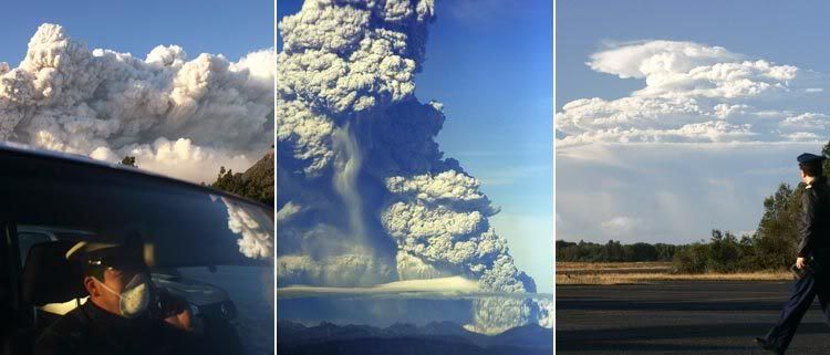
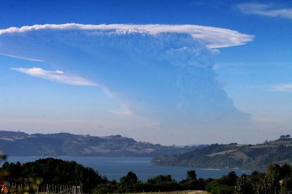
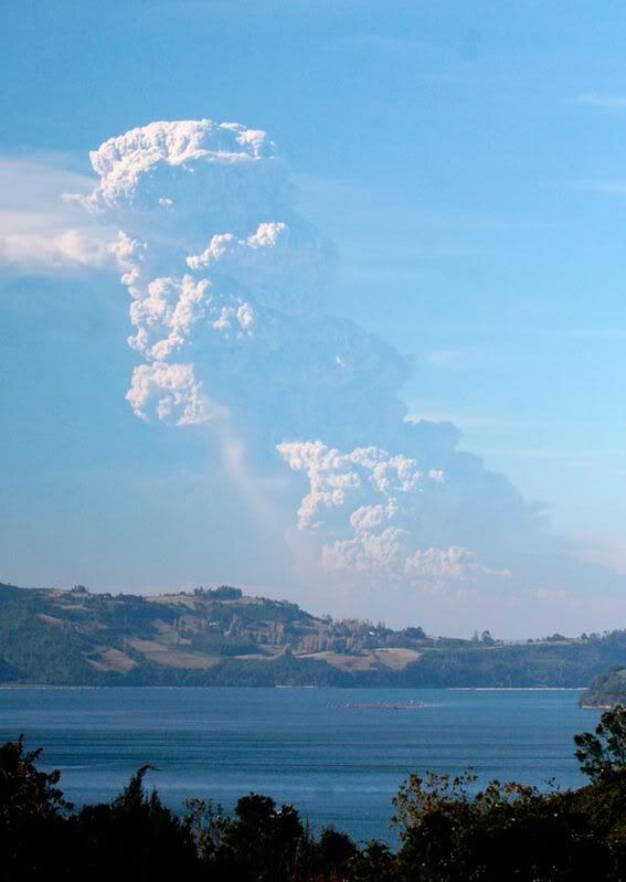
quote:Government Vulcanologist Spells Out “Worst Case Scenario”
Chilean authorities are considering the possibility that Region X’s Chaitén Volcano, now in its sixth day of continuous eruption, might collapse and thus release a torrent of red-hot pyroclastic material – burning gas and rocks – that could devastate the surrounding area.
Very much a “worst case scenario,” the possibility is nevertheless a very real one, vulcanologist Luis Lara of Chile’s National Geologic and Mining Service (SERNAGEOMIN) told reporters Thursday afternoon.
“That’s precisely the reason we recommended that authorities define a restricted area, because this is a real possibility with volcanoes that are similar to Chaitén. We can’t offer any kind of probability that this will happen, or say for sure how things will play out. It’s a worst case scenario,” said Lara.
There is indeed precedent for such concern, according to the SERNAGEOMIN official, who pointed out that similar volcanoes – in Mexico and the Philippines, for example – have collapsed on the seventh or eight day of continuous eruption. Friday will mark the Chaitén Volcano’s seventh day of eruption.
“Pompeii is in some ways similar,” said Lara, referring to the Roman city famously destroyed in AD 79 by Mount Vesuvius. “There was a pyroclastic flow that resulted in the consequences we all know. That’s exactly the worst case scenario that we’ve defined here.”
Pyroclastic flows are rapid currents of hot gas and rock that can escape from a volcano crater and travel downhill toward surrounding areas. Lara and his colleagues, in fact, have already observed such pyroclastic escapes in photographs and video recordings of the ongoing Chaitén eruption.
“There’s evidence that this is happening. One can see pyroclastic flows descending past the edge of the dome, where the craters are located. Although they aren’t very dense and are of relatively small volume, they’re crashing against the walls of the cauldron and have burned vegetation in this part,” said Lara.
The vulcanologist suspects such flows are responsible for a noted temperature increase (of between 7 and 17 degrees Celsius) in the nearby Chaitén and Raya Rivers.
The eruption, Chaitén’s first in recorded history, released a massive billow of ash that was visible as far away as Puerto Montt, some 200 kilometers to the north. Volcanic soot began to rain down, blanketing Chaitén and other area towns such as Futaleufú, and contaminating local water supplies.
The volcanic activity intensified between Tuesday and Thursday as authorities reported seeing lava emanating from the volcano’s crater. The natural disaster prompted government officials to order the mandatory evacuation of local residents and all emergency workers within 50 kilometers of the volcano.
So far the volcano has emitted an estimated two cubic kilometers of ash, said Lara. Smoke from the crater has shot up as high as 15 kilometers. The massive plume of smoke, furthermore, now stretches as far away as Buenos Aires, Argentina, arpproximately 500 kilometers to the east.
The Chilean government on Thursday announced a series of tax-relief measures for victims of the Chaitén Volcano eruptions. Officials disclosed their plans as the Chilean military evacuated the remaining residents holed up in rural towns surrounding the volcano.
The eruption, which began early Friday morning, released a massive billow of ash that was visible as far away as Puerto Montt, some 200 kilometers to the north. Volcanic soot began to rain down, blanketing Chaitén and other area towns such as Futaleufú, and contaminating local water supplies (ST, May 5). NASA satellite photos released several days later showed the cloud of smoke spreading towards Argentina's Atlantic coast, some 500 miles to the east.
Still, a small group of civilians refused to leave two villages surrounding Chaitén, a municipality located 10 kilometers from the exploding volcano with the same name. The group included local radio show host Bernardo Riquelme, who refused to stop broadcasting for the few inhabitants left behind. All citizens were finally evacuated after government officials threatened to extract them from their homes by force.
Meanwhile, Chile's Tax Service (SII) announced a “huge tax pardon” for all inhabitants affected by the volcano. Accompanied by Finance Ministry officials and government Treasurer Pamela Cuzmar, SII President Ricardo Escobar said the plan calls for erasing all interest on residents' debts and exempting them from paying property taxes for at least four years. He said the measures alone will allow area residents to save a total of Ch$1.3 billion pesos (US$2.8 million).
“We have decided to take measures that we believe are appropriate for a disaster of this magnitude,” affirmed Finance Ministry Undersecretary María Olivia Recart. “They are exceptional measures, and they will go a long way to alleviating the stressful situation facing many local residents.”
Chile has one of the world's most active string of volcanoes. It is home to some 2,000 volcanoes, 500 of which experts say are potentially active. Around 60 have erupted over the past 450 years.
Op zaterdag 15 augustus 2009 23:05 schreef eer-ik het volgende:
Ik vind je sig nogal denigrerend.
Ik vind je sig nogal denigrerend.
Waarom niet? Ben jij geoloog?
Op zaterdag 15 augustus 2009 23:05 schreef eer-ik het volgende:
Ik vind je sig nogal denigrerend.
Ik vind je sig nogal denigrerend.
Nee maar er is weer eens een vulkaan actief... en één iemand houdt rekening met het ergste scenario... tja dat is altijd wel denk ik

De tekenen zijn hetzelfde als bij uitbarstingen die elders hebben plaatsgevonden. Dan is het natuurlijk makkelijk om een vergelijking te maken én mensen houden wel van doemdenken.
Het is iig niet op niks gebaseerd.
Het is iig niet op niks gebaseerd.
Op zaterdag 15 augustus 2009 23:05 schreef eer-ik het volgende:
Ik vind je sig nogal denigrerend.
Ik vind je sig nogal denigrerend.
ERUTPION PAROXYSMALE DU VOLCAN CHAITEN
Le volcan est entré hier matin dans une phase éruptive paroxysmique,engendrant une très forte émission de cendre jusqu'à 30km d'altitude et de grosses nuées ardentes,détruisant une grande quantitée de la forêt qui recouvrait la région.L'alerte est maximale(Rouge) et tous les habitants vivant dans un rayon de 50km ont été évacués.Les deux petis cratères qui occupaient la caldeira avant l'éruption,ont fusionné, ne formant + qu'un grand cratère.Sources:Romandie-news;TF1.fr;Activolcans
Kan iemand mij zeggen wat dit is? "une phase éruptive paroxysmique"
Dan kan ik dat stukje vertalen, er zat ook weer een filmpje bij.
http://julien-agence.monsite.wanadoo.fr/page6.html
be nice or go away
een plotselinge (aanval van) eruptieve fase.quote:Op vrijdag 9 mei 2008 11:52 schreef kahaarin het volgende:
ERUTPION PAROXYSMALE DU VOLCAN CHAITEN
Kan iemand mij zeggen wat dit is? "une phase éruptive paroxysmique"
Dan kan ik dat stukje vertalen, er zat ook weer een filmpje bij.
http://julien-agence.monsite.wanadoo.fr/page6.html
Op zaterdag 15 augustus 2009 23:05 schreef eer-ik het volgende:
Ik vind je sig nogal denigrerend.
Ik vind je sig nogal denigrerend.
Translation: Frans » Nederlandsquote:Op vrijdag 9 mei 2008 11:52 schreef kahaarin het volgende:
ERUTPION PAROXYSMALE DU VOLCAN CHAITEN
Le volcan est entré hier matin dans une phase éruptive paroxysmique,engendrant une très forte émission de cendre jusqu'à 30km d'altitude et de grosses nuées ardentes,détruisant une grande quantitée de la forêt qui recouvrait la région.L'alerte est maximale(Rouge) et tous les habitants vivant dans un rayon de 50km ont été évacués.Les deux petis cratères qui occupaient la caldeira avant l'éruption,ont fusionné, ne formant + qu'un grand cratère.Sources:Romandie-news;TF1.fr;Activolcans
Kan iemand mij zeggen wat dit is? "une phase éruptive paroxysmique"
Dan kan ik dat stukje vertalen, er zat ook weer een filmpje bij.
http://julien-agence.monsite.wanadoo.fr/page6.html
De vulkaan heeft gisterochtend in een eruptive paroxysmale fase, waardoor een zeer sterke emissie van as tot 30 km hoogte en grote wolken branden, vernietiging van een grote hoeveelheid van het bos, dat betrekking had op de regio. De signalering is maximaal (Red) en alle inwoners wonen in een straal van 50km werden geëvacueerd. De twee kleine kraters die bezet de caldera vóór de uitbarsting, zijn gefuseerd en vormen + heeft een grote krater. Bronnen: Romandie-nieuws; TF1.fr; Activolcans
Google Translate, erg fijn
Ah thnx!quote:Op vrijdag 9 mei 2008 11:58 schreef OA het volgende:
[..]
een plotselinge (aanval van) eruptieve fase.
De vulkaan is gisterochtend een plotselinge eruptieve fase ingegaan, en een zeer sterke uitstoot van as tot 30km hoogte en hevige vurige wolken zijn het gevolg, daardoor is een grote oppervlakte van het bos vernietigd, er is rood alarm geslagen en alle inwoners wonend in een straal van 50km van de 2 kleine kraters zijn geevacueerd, de 2 kleine kraters zijn gefuseerd en vormen nu 1 grote krater.
be nice or go away
Frans lezen lukt wel ik wist alleen niet wat dat dikgedrukte stukje betekende, en google translate ook niet blijkbaar!quote:Op vrijdag 9 mei 2008 12:00 schreef Bakakame het volgende:
[..]
Translation: Frans » Nederlands
De vulkaan heeft gisterochtend in een eruptive paroxysmale fase, waardoor een zeer sterke emissie van as tot 30 km hoogte en grote wolken branden, vernietiging van een grote hoeveelheid van het bos, dat betrekking had op de regio. De signalering is maximaal (Red) en alle inwoners wonen in een straal van 50km werden geëvacueerd. De twee kleine kraters die bezet de caldera vóór de uitbarsting, zijn gefuseerd en vormen + heeft een grote krater. Bronnen: Romandie-nieuws; TF1.fr; Activolcans
Google Translate, erg fijn
Maar goed, volgens mij snap ik het nu wel.
be nice or go away

Chaiten Volcano Erupts
On May 2, 2008, Chile’s Chaitén Volcano erupted, sending plumes some 30 kilometers (18.6 miles) skyward, and blanketing some nearby areas in as much as 1.5 meters (5 feet) of volcanic ash. In the week that followed the initial eruption, local authorities established an evacuation zone with a radius of 50 kilometers (31 miles) around the volcano, warning holdouts that they would be evacuated by force, if necessary.
On February 21, 2000, the Enhanced Thematic Mapper on NASA’s Landsat satellite captured the volcano in a state of calm. In this image, the volcano’s caldera appears as a pale brown crater inside an ocean of lush green vegetation that covers the mountainous region. To the southwest is the nearby coastal town with the same name as the volcano. The satellite’s view is obscured only by the occasional cloud.
The tranquility of the volcano apparent in this image has been the norm throughout recorded human history. The May 2008 eruption was a surprise—Chaitén’s first eruption in more than 9,000 years. Even when a volcano has been active in recent history, the surrounding areas often provide good reasons to settle, including fertile soils and milder climates arising from high altitudes (at least in the tropics).
Vulkaan Etna is weer uitgebarstenquote:Op het Italiaanse eiland Sicilië is de vulkaan Etna weer uitgebarsten. Sinds 15:00 uur vanmiddag stroomt er lava uit een krater aan de zuidoostelijke kant van de vulkaan het gebied Valle del Bove in. Volgens het Instituut voor geofysica en vulkanologie, dat gevestigd is in Palermo, is het gebied waar de lava stroomt onbewoond.
De Etna is de op één na actiefste vulkaan van Europa. De vorige uitbarsting is nog niet zo lang geleden en dateert van september 2007. De uitbarsting ging toen gepaard met vliegende rotsblokken, waardoor het nabij gelegen vliegveld van Catania werd gesloten. De zwaarste uitbarsting van de laatste jaren vond plaats in 2001; de regering riep toen de noodtoestand uit.
Op zaterdag 15 augustus 2009 23:05 schreef eer-ik het volgende:
Ik vind je sig nogal denigrerend.
Ik vind je sig nogal denigrerend.
http://www.patagoniatimes.cl/content/view/501/1/quote:CHILE VOLCANO ZONE MAY BE PERMANENTLY UNLIVABLE
Chilean President Michelle Bachelet on Saturday warned that towns surrounding Region X’s Chaitén Volcano, which has been in constant eruption since May 2, might become permanently unlivable. Bachelet's remarks came after the National Geologic and Mining Service (SERNAGEOMIN) delivered her an ominous report putting the possibility of the volcano's collapse above 50 percent.
“There are experts who say that lava from the Chaitén Volcano could flow directly towards the town of Chaitén,” said Bachelet. “These experts are recommending that the town of Chaitén never be inhabited again.”
SERNAGEOMIN vulcanologist Luis Lara first disclosed on Thursday that the volcano could implode, thus releasing a streatm of red-hot pyroclastic material (burning gas and rock) capable of destroying everything in its path. Pyroclastic flows are rapid currents of hot gas and rock that can escape from a volcano crater and travel downhill toward surrounding areas.
The Chilean daily La Tercera reported on Sunday that a SERNAGEOMIN study had put the odds of such a collapse as at least 50 percent. The document said that there was increased build-up in the dome of magma currently covering the volcano's crater. Futhermore, the material accumulating in the area was “highly dense,” and thus more prone to collapse. SERNAGEOMIN said that any implosion would cause complete destruction of everything within a 15 kilometer radius around the peak, an area which encompasses Chaitén, Santa Barbara, and several rural farming villages.
Bachelet, who had returned on Friday to the area affected by the eruption, acknowledged this threat while touring the town of Palena.
“The people (who live in the area around the volcano) represent our top priority right now,” Bachelet said. “This tremendous column of burning rock and magma could reach speeds of between 100 and 400 kilometers per hour. At that rate, it could reach the town of Chaitén in six minutes.”
Still, Bachelet said that not all scientists agreed on the possibility of such an event, adding that some officials had even suggested that local communities covered in ash by the volcano blasts could be fully functional within a few years.
“We have never had a situation quite like this in Chile,” she said.
The eruption, Chaitén’s first in recorded history, released a massive billow of ash that was visible as far away as Puerto Montt, some 200 kilometers to the north. Volcanic soot began to rain down, blanketing Chaitén and other area towns such as Futaleufú, and contaminating local water supplies.
The volcanic activity intensified between Tuesday and Thursday as authorities reported seeing lava emanating from the volcano’s crater. The natural disaster prompted government officials to order the mandatory evacuation of local residents and all emergency workers within 50 kilometers of the volcano (ST, May 8).
More than 12,000 civilians were evacuated by week's end, including a few dozen residents holed up in Chaitén and Santa Barbara. The Agriculture Ministry had also initiated plans to rescue most of the 40,000 cows, sheep, and other livestock in nearby towns.
Still, the Region X Governor's Office issued a decree preventing animal rights organizations from traveling to Chaitén in order to rescue an estimated 600 pets, mostly horses, dogs and cats. As of Sunday, local animal activists said that they were preparing legal arguments in order to have the decision overturned. Bloomberg reported that the U.S. Human Society had announced plans to send a team to Chaitén, described as “a city overtaken by dogs.” Meanwhile, more than 600 pets in Futaleufú were being successfully aided by volunteers.
New evidence suggests that southern Chile’s Monte Verde archaeological site, located some 35 kilometers from Puerto Montt (Region), is approximately 14,000 years old, making it the oldest known human settlement in the Americas.
The new findings, published this week in Science Magazine, confirm what researchers studying the site have suspected for years: that early migrants to the Americas made their way south far earlier than previously thought. The evidence goes in the face of a long-standing theory among U.S. archaeologists that the first visitors to the Americas – the Clovis people – crossed the Russia-Alaska land bridge (now the Bering Straight) some 13,000 years ago.
University of Vanderbilt archaeologist Tom Dillehay and others studying the Monte Verde site, which was discovered by accident in 1976, identified nine different types of algae used by settlers as both food and medicine. Using carbon dating techniques, the scientists determined the material to be between 14,220 and 13,980 years old – roughly 1,000 years older than any other known settlement in the hemisphere.
“These findings support the archaeological interpretation of the site and indicate that the site's inhabitants used seaweed from distant beaches and estuarine environments for food and medicine. These data are consistent with the ideas that an early settlement of South America was along the Pacific coast and that seaweeds were important to the diet and health of early humans in the Americas,” an abstract for the Science article reads.
Researchers believe the early settlement supported some 25 community members. At the time, suggest Dillehay and his colleagues, the nearby island of Chiloé was likely connected to the Chilean mainland.
Op zaterdag 15 augustus 2009 23:05 schreef eer-ik het volgende:
Ik vind je sig nogal denigrerend.
Ik vind je sig nogal denigrerend.
maar zonder dat de magmakamer leeg wordt "geërupteerd"?quote:the possibility of the volcano's collapse above 50 percent.
Past dit wel hier, of is een nieuw topic beter op z'n plaats?
quote:Gedurfde hypothese: aardse kernreactie
Een kernreactie diep in de aarde genereert warmte die vulkanen doet uitbarsten. Deze afwijkende hypothese durfden de gerenommeerde tijdschriften niet aan.
Rotterdam, 22 mei. Diep in de aarde, langs de buitenkant van de aardkern, ligt een natuurlijke kernreactor verscholen die duizend keer krachtiger is dan de grootste kerncentrale. Het uranium, de splijtstof die nodig is voor deze reactie, ligt opgesloten in een laag superzwaar gesteente van maximaal een paar honderd kilometer dik. De splijtingsproducten van kernreacties op circa drieduizend kilometer diepte kunnen de afwijkende samenstelling verklaren van vloeibaar gesteente dat aan het aardoppervlak komt op vulkanische eilanden als Hawaii en Réunion en langs spreidingsruggen op de oceaanbodem.
Rob de Meijer, emeritus hoogleraar nucleaire fysica aan de Rijksuniversiteit Groningen en aardwetenschapper Wim van Westrenen (VU Amsterdam) publiceren deze opmerkelijke hypothese in een artikel dat binnenkort verschijnt in het South African Journal of Science. „Een relatief obscuur tijdschrift”, erkent Van Westrenen. „Maar we zagen geen andere mogelijkheid. Als je een kernreactor in de aarde veronderstelt, dan kan dat verregaande consequenties hebben.
„Wij denken dat een uit de hand gelopen kernreactie in het binnenste van de aarde 4,5 miljard jaar geleden kan hebben geleid tot het ontstaan van de maan. We hebben daarover een artikel aangeboden aan Nature en daarna aan Geophysical Research Letters, maar de referenten vonden het te veel ineens. Onze ideeën zingen nu rond en het leek ons verstandig om ten minste een deel ervan te publiceren voordat iemand anders ermee op de loop gaat.” Pikant: maandag besteedde Nature op haar website aandacht aan de Nederlandse studie waarvoor haar wetenschappelijke referenten eerder de neus ophaalden.
Gebergte
Van Westrenen stelt zich het gesteente met de splijtstof voor als een ‘gebergte’ op de buitenkern van de aarde. De bergtoppen steken in de diepe mantel omhoog. De diepe mantel is de circa 3.000 kilometer dikke aardlaag tussen de aardkern en de buitenste laag: de aardkorst.
Bekend is dat instabiele elementen in de aardmantel vervallen en warmte produceren. Dit proces is een belangrijke motor achter de stromen van opwarmend en afkoelend gesteente in de aardmantel en uiteindelijk vulkanisme. Een echte kernreactie gaat verder en kan ontstaan als voldoende van de kerndeeltjes die vrijkomen uit een radioactief element als uranium of thorium andere kernen raken en een kettingreactie veroorzaken.
Dat natuurlijke kernreacties op aarde kunnen ontstaan, was bekend. In Gabon zijn resten gevonden van een twee miljard jaar oude natuurlijke kernreactor. Dat de metalen kern van de aarde een kernreactor zou herbergen, is in de jaren tachtig al geopperd door de Amerikaan Marvin Herndon, maar Van Westrenen is daar sceptisch over. „De aardkern bestaat uit ijzer en nikkel. Een radioactief element als uranium lost daarin niet makkelijk op.”
De Nederlanders hebben uitgerekend hoeveel uranium past in gesteente op zeer grote diepte. Calciumsilicaatperovskiet, één van de mineralen die onder hoge druk ontstaan, zou in zijn kristalstructuur zoveel uranium op kunnen nemen dat de voor een kernreactie benodigde kritische massa ontstaat.
Verborgen
Een diepe kernreactor zou de hoge concentratie kunnen verklaren van varianten van elementen als xenon en helium in vulkanische gesteenten als basalt. Van Westrenen: „Uit een studie in Science uit 2005 blijkt dat uitvloeiingsgesteenten als basalt, die hun oorsprong in de aardmantel vinden, minder zeldzame aardmetalen bevatten als neodymium, en ook minder uranium dan meteorieten die we op aarde vinden. Omdat geologen ervan uitgaan dat de aarde en meteorieten – net als de rest van ons zonnestelsel – uit hetzelfde materiaal bestaan, moet de rest ergens in een aards reservoir verborgen zitten.”
De laag zwaar gesteente met de kernreactor zou dat diepe reservoir kunnen zijn en meteen verklaren waarom varianten van xenon en helium in vulkanisch gesteente wél in ruime mate aanwezig zijn. Deze isotopen zijn precies de splijtingsproducten die vrijkomen bij kernreacties met thorium en uranium.
Of de hypothese standhoudt, zal duidelijk worden als wetenschappers meer te weten komen over de herkomst van anti-neutrino’s, deeltjes die bij kernreacties vrijkomen. Met een detector in Japan is in 2005 voor het eerst vastgesteld dat deze deeltjes niet alleen ontstaan in het heelal, maar ook in de aarde. De Meijer werkt aan een proefopstelling voor een reeks detectoren waarmee hij het bestaan van de diepe kernreactor uiteindelijk zou kunnen bewijzen.

Op zaterdag 15 augustus 2009 23:05 schreef eer-ik het volgende:
Ik vind je sig nogal denigrerend.
Ik vind je sig nogal denigrerend.
Nieuw topic denk ik beter.. boeiende materie iig..quote:Op vrijdag 23 mei 200808:14 schreef OA het volgende:
Past dit wel hier, of is een nieuw topic beter op z'n plaats?
[..]
[afbeelding]
interessant stukjequote:Op vrijdag 23 mei 2008 08:14 schreef OA het volgende:
Past dit wel hier, of is een nieuw topic beter op z'n plaats?
[..]
[ afbeelding ]
misschien wel een eigen topic waard ja
[b]Op maandag 6 september 2010 00:28 schreef tong80 het volgende:[/b]
GVD Wat moet jij een trotse vader zijn :)
:P
GVD Wat moet jij een trotse vader zijn :)
:P

Is er alquote:Op vrijdag 23 mei 2008 10:02 schreef Againzender het volgende:
[..]
interessant stukje
misschien wel een eigen topic waard ja
Op zaterdag 15 augustus 2009 23:05 schreef eer-ik het volgende:
Ik vind je sig nogal denigrerend.
Ik vind je sig nogal denigrerend.
Nog altijd verhoogde activiteit Semeru vulkaan
quote:25 mei 2008 - De activiteit van de Semeru vulkaan bij Lumajang in oostelijk Java is nog altijd relatief hoog. Gebaseerd op seismische informatie van de observatiepost Gunung Sawur in het dorp Sumber Wulu, subdistrict Candipuro; er zijn 90 vulkanische trillingen, zeven magmatisch trillingen en 30 tectonische trillingen waargenomen in de afgelopen 24 uur.
Is dat bij jou in de buurt?quote:Op maandag 26 mei 2008 11:35 schreef indahnesia.com het volgende:
Nog altijd verhoogde activiteit Semeru vulkaan
[..]
be nice or go away
Neuh, een deur of twee verder dan de Keludquote:
quote:Op maandag 26 mei 2008 17:24 schreef indahnesia.com het volgende:
[..]
Neuh, een deur of twee verder dan de Kelud
Hopelijk niet natuurlijk maar als hij gaat ga jij dan ook?
be nice or go away
moah, deze vulkaan rommelt altijd wel een beetje, maar als het erger wordt is het misschien wel mooi te gaan ja.. ik houd het dus in de gaten.quote:Op maandag 26 mei 200820:42 schreef kahaarin het volgende:
[..]
[afbeelding] Kijken of deze wel wil? [afbeelding]
Hopelijk niet natuurlijk maar als hij gaat ga jij dan ook? [afbeelding] Foto's maken bedoel ik hoor, niet uitbarsten. [afbeelding]
Door die nieuwe berichten over andere vulkanen sneeuwt de Chaiten een beetje onder, dit zijn de berichten van gisteren, er heeft zich dus opnieuw een krater gevormd, er word nog steeds as uitgestoten en het stadje is ondergelopen, wordt vervolgd dus.
5e bericht ongeveer.
http://julien-agence.monsite.wanadoo.fr/page6.htmlquote:De uitbarsting van de Chileense vulkaan Chaiten gaat nog steeds door. De nieuwe krater, die zich op de zijkant van de vorige krater bevind, stoot een +/- 7000m hoge aswolk uit . De autoriteiten hebben besloten het rode alarm te vervangen voor oranje voor de luchtvaart. De stad Chaiten is volledig bedekt door modderig water. Het risico op een grote uitbarsting is er nog steeds, er blijft 24 uur per dag toezicht.
26/05/2008 CHAITEN
L'éruption du volcan Chilien Chaiten se poursuit.Le nouveau dôme de lave qui croit sur le flanc du précédent dôme émet une importante colonne de cendre haute de 7000m environ.Les autorités ont donc décidés d'abaisser le niveau d'alerte du Rouge à l'orange pour l'aviation.La ville de Chaiten est complètement noyée sous les eaux boueuses.Le risque d'une grande éruption n'est toujours pas écartée, la surveillance se fait 24/24h.A suivre...
5e bericht ongeveer.
be nice or go away
Sidoarjo moddervulkaan kan wellicht instorten
quote:De Indonesische moddervulkaan lijkt uit zichzelf ineen te storten, dit blijkt uit een nieuw onderzoek waarvan de resultaten op de tweede verjaardag van deze immer groeiende natuurramp werden gepresenteerd. Iedere dag komt er meer dan 100.000 kubieke meter hete, stinkende modder omhoog uit de moddervulkaan, welke twee jaar geleden actief werd tijdens een diepe boring in een nabije onderzoeksbron.
Vulkaanuitbarsting op Galapagos-eilanden
Op de Galapagos-eilanden is dit weekeinde een vulkaan uitgebarsten. De Cerro Azul spuwt na tien jaar rust weer lava uit.
Gevaar voor de bijzondere populatie reuzenschildpadden van het eiland Isabella is er niet, aldus natuurbeschermers. Tijdens de laatste uitbraak, in 1998, takelden reddingswerkers met helikopters reuzenschildpadden uit de krater om hen te redden van de gloeiende lavastroom. Nu stroomt de lava echter de andere kant uit.
De Galapagos-eilanden horen bij Ecuador en liggen duizend kilometer ten westen van het Zuid-Amerikaanse continent. De Engelse bioloog Charles Darwin ontwikkelde zijn evolutietheorie nadat hij er de unieke dieren had onderzocht. De eilanden zijn dunbevolkt, maar de Verenigde Naties waarschuwden vorig jaar dat toerisme en immigratie de natuur van de archipel bedreigen.
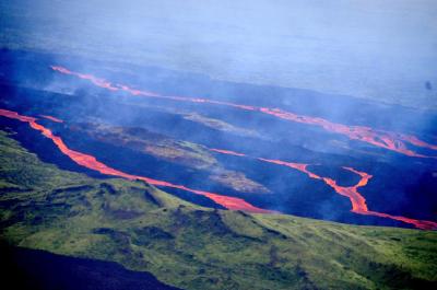
Bron: FP (ANP)
Op de Galapagos-eilanden is dit weekeinde een vulkaan uitgebarsten. De Cerro Azul spuwt na tien jaar rust weer lava uit.
Gevaar voor de bijzondere populatie reuzenschildpadden van het eiland Isabella is er niet, aldus natuurbeschermers. Tijdens de laatste uitbraak, in 1998, takelden reddingswerkers met helikopters reuzenschildpadden uit de krater om hen te redden van de gloeiende lavastroom. Nu stroomt de lava echter de andere kant uit.
De Galapagos-eilanden horen bij Ecuador en liggen duizend kilometer ten westen van het Zuid-Amerikaanse continent. De Engelse bioloog Charles Darwin ontwikkelde zijn evolutietheorie nadat hij er de unieke dieren had onderzocht. De eilanden zijn dunbevolkt, maar de Verenigde Naties waarschuwden vorig jaar dat toerisme en immigratie de natuur van de archipel bedreigen.
Bron: FP (ANP)

Chaiten Volcano Erupts
Chile’s Chaitén Volcano continued releasing ash and steam on May 31, 2008. The Moderate Resolution Imaging Spectroradiometer (MODIS) on NASA’s Aqua satellite took this picture the same day. In this image, the plume blows toward the east, fanning out as it goes. The white color of the plume suggests that water vapor predominates. The red outline at the volcanic summit is a hotspot where the satellite has detected unusually high surface temperatures.
Clear skies over the coastline show that much of the land along the coast has assumed the gray-beige dullness characteristic of volcanic ash. A May 30 bulletin issued by Chile’s Servicio Nacional de Geología y Minería stated that recent winds had dispersed volcanic ash along Chile’s coast between Chaitén and Chumildén to the north. The report also stated that, although seismic activity at the volcano had decreased, the possibility of explosive eruptions and pyroclastic flows could not be ruled out.
caldera volcano formed by a collapse of the volcanic summit that creates a circular depression. Prior to its May 2008 eruption, the volcano had been dormant for more than 9,000 years.

In May 2008, the 4,000 residents of the fishing town of Chaitén were evacuated after the eruption of Chaitén Volcano 10 kilometers (5.4 miles) to the northeast. In addition to the threat of ashfall or an explosive eruption, the town is being flooded as ash and debris from the volcano choke the surrounding rivers.
A fresh delta now extends into the the harbor and Bahía Chaitén, once the gateway to Chile’s remote and rugged Palena Province and Pumalín National Park. (The size of the delta is exaggerated in this image, which was acquired at or near low tide). Mud also filled the river channel, forcing a slurry of ash and water over the banks of Río Blanco and through the town’s streets.
As of May 30, 2008 Chaitén Volcano continues to erupt, steadily spewing a column of ash and steam several kilometers into the air. Simultaneously, Chaiten’s lava dome continues to grow as thick lava emerges from the Earth.
quote:Moddervulkaan door boring
Mensen hebben geen invloed op vulkanen wordt vaak gedacht. In verreweg de meeste gevallen is dat ook zo, maar niet altijd. Op 29 mei 2006 vormde zich de moddervulkaan Lusi op oostelijk Java. Onderzoek van een internationaal team van wetenschappers wijst uit dat een gasboring op slechts 150-200 meter van de plaats van ontstaan van moddervulkaan de oorzaak is. Niet een aardbeving zoals werd gedacht. Dit is gepubliceerd in het tijdschrift Earth and Planetary Science Letters.
Moddervulkaan
Dit type vulkaan spuwt geen lava zoals de meeste vulkanen, maar ontdoet zich van gas en modder. Temperaturen zijn dan ook een stuk lager. Omdat de stroperigheid van de modder laag is, zeker ten opzichte van sommige lavatypes, hebben moddervulkanen een zeer lage helling. De vrijkomende gassen zijn vooral methaan (CH4), koolstofdioxide (CO2) en stikstof (N2). Moddervulkanen komen op het land en in de oceaan voor en worden op alle werelddelen gevonden. Ze ontstaan voornamelijk in gebieden waar koolwaterstoffen aanwezig zijn én in tektonisch actieve gebieden.
Oost-Java en Lusi
Java is onderdeel van een geologische depressie, die omgeven is door breuken (slenk). Daarnaast is Oost-Java rijk aan gas en olievelden. Deze worden dan ook volop geëxploiteerd door drie bedrijven. Ook moddervulkanen steken hun kop op in deze regio.
De naam van de moddervulkaan Lusi op Oost-Java is een samentrekking van Lumpur Sidoarja. Lumpur betekent modder en Sidoarja is de streek. Op 29 mei 2006 ontstond de moddervulkaan en hij is nog steeds actief. Pogingen om de vulkaan te stoppen zijn mislukt. Meer dan 6,5 km2 is bedekt onder de modder en meer dan 30.000 mensen zijn verhuisd, een ramp voor de regio. Gassen als methaan, koolstofdioxide en het giftige waterstofsulfide (HS) komen uit de vulkaan en de temperatuur van het modder loopt op tot 100°C.
Aardbeving als oorzaak?
Deze ramp lijkt op het eerste gezicht puur natuur. Modderstromen komen immers natuurlijk voor. De directe oorzaak zou de aardbeving in Yogyakarta zijn die op 27 mei 2006, twee dagen voor het ontstaan van de moddervulkaan, de omgeving schokte met een kracht van 6,3 op de schaal van Richter. Bovendien is bekend dat aardbevingen moddervulkanen veroorzaken. De oorzaak lijkt voor de hand liggend.
Toch ligt het niet zo eenvoudig. De afstand tot de moddervulkaan vanaf het epicentrum van de beving is maar liefst 250 km. Ook zijn er in de afgelopen dertig jaar zwaardere aardbevingen geweest, die ook nog eens dichterbij plaatsvonden. Er ontstonden toen geen moddervulkanen. Verder was de door de aardbeving van 27 mei 2006 ontstane verandering in grondwaterdruk te verwaarlozen. Daarnaast weerleggen de onderzoekers de theorie dat een breuk in de aardkorst opnieuw zou zijn geactiveerd door de aardbeving. De kracht van de beving was hiervoor te zwak.
Banjar Panji-1 gasboring
De echte oorzaak van de moddervulkaan is een gasboring door het bedrijf PT Lapindo Brantas, slechts 150-200 m van de plaats van ontstaan van de moddervulkaan. De boring ging tot een diepte van 2800 m, maar had vanaf 1100 m geen beschermend, drukwerend omhulsel meer. Enkele uren na de aardbeving van 27 mei werd besloten de boor en boorpijp terug te halen, omdat de aanwezige modder niet meer stroomde. Na stopzetten kwam vloeistof en gas in het ontstane gat. Het dichtmaken van het boorgat zorgde voor extra druk, waardoor op 29 mei 2006 uiteindelijk de moddervulkaan ontstond.
Hoe lang het uitbraken van modder en gas nog voorduurt is onbekend. Eénmaal de kurk eruit betekent dus grote problemen. Wie betaalt de rekening?...


http://www.kennislink.nl/web/show?id=206537
===================================
http://www.nrc.nl/wetensc(...)_Java_door_gasboringquote:Moddervulkaan Java door gasboring
Jakarta, 11 juni. De moddervulkaan die sinds mei 2006 het Indonesische eiland Java teistert, is veroorzaakt door gasboringen. Dat concluderen internationale onderzoekers in een artikel in Earth and Planetary Science Letters.
Het bedrijf Lapindo Brantas, dat in het gebied naar gas boort, heeft steeds gezegd dat een aardbeving de oorzaak was van de stinkende modder die al meer dan 50.000 mensen dakloos heeft gemaakt en hele dorpen heeft verzwolgen.
Deskundigen hebben steeds gezegd dat een boring van Lapindo de oorzaak was. De hete, stinkende modderfontein begon op 29 mei 2006, de dag dat Lapindo naar gas boorde. Het bedrijf van eigenaar Aburizal Bakrie, de Indonesische minister van Sociale Zaken en een van de rijkste zakenlieden van het land, wees een aardbeving bij Yogyakarta twee dagen voor de boring, als oorzaak aan. Bij die aardbeving kwamen 6.000 mensen om. Het epicentrum van de beving, met een kracht van 6.3 op de schaal van Richter, lag echter 250 kilometer van de moddervulkaan.
Volgens geoloog Michael Manga van de universiteit van Berkeley was de aardbeving niet zwaar genoeg om op zo’n afstand een dergelijke modderstroom op gang te brengen.
Richard Davies van de universiteit van Durham, die al eerder bedenkingen uitte over de verklaring van het gaswinningsbedrijf, zegt nu dat er op de dag voor de stroom op gang kwam een grote hoeveelheid gas en water in het boorgat kwam, waardoor de druk opliep en het water naar boven werd geduwd, samen met rotsblokken. Daardoor scheurde de bodem.
Nog steeds stroomt dagelijks zo’n 100.000 kubieke meter modder uit de scheur. Volgens geoloog Manga is het nauwelijks mogelijk de scheur te dichten.
Lapindo Brantas zegt bereid te zijn tot een „wetenschappelijk debat” over de oorzaak. Het bedrijf twijfelt echter aan de deskundigheid van het onderzoeksteam. De Indonesische regering schat de totale schade op meer dan 800 miljoen dollar en heeft Lapindo opgedragen de helft daarvan te betalen, deels in de vorm van een schadevergoeding aan de slachtoffers.
Op zaterdag 15 augustus 2009 23:05 schreef eer-ik het volgende:
Ik vind je sig nogal denigrerend.
Ik vind je sig nogal denigrerend.

Llaima (file photo) began spewing lava Tuesday morning
Photo courtesy of National Geology and Mineral Service de Chile
http://www.patagoniatimes.cl/content/view/573/1/quote:CHILE’S LLAIMA VOLCANO OOZES LAVA
Southern Chile’s Llaima volcano woke up early Tuesday morning from a short, six-month nap and is currently oozing a stream of lava that already stretches for nearly a kilometer.
The eruption began at roughly 4 a.m., six month to the date after the 10,530-foot Region IX volcano ushered in the new year with a spectacular show (PT, Jan. 3).
Lava flowing down the volcano’s western slope has extended approximately 800 meters, prompting authorities to so far evacuate approximately 25 people. Chile’s National Emergency Office (ONEMI) is particularly concerned about residents in the towns of La Selva and Danubio.
ONEMI is also preparing for the possibility that the lava flow, which melts snow and ice as it descends, could produce dangerous mudslides. Due to heavy cloud cover, Chilean authorities have so far been unable to conduct flyovers.
Region IX Governor Nora Barrientos has declared a yellow alert for the communities of Curacautin, Cunco, Melipeuco and Vilcun.
Chile is one of the most volcanically active countries in the world. Earlier this year a massive and prolonged eruption by Region X’s Chaiten volcano forced the complete evacuation of a nearby city of the same name. Ash from the volcano – combined with subsequent floods – have all but destroyed the town. The volcano, in the meantime, continues to smoke.
Op zaterdag 15 augustus 2009 23:05 schreef eer-ik het volgende:
Ik vind je sig nogal denigrerend.
Ik vind je sig nogal denigrerend.
http://www.patagoniatimes.cl/content/view/575/1/quote:VOLCANO ERUPTION PROMPTS RED ALERT IN CHILE
New eruptions from southern Chile's Llaima volcano forced Chile\s government to declare a ‘Red Alert’ Thursday for residents of nearby towns. The advancing lava flow is 50 meters wide and has already stretched more than 2 kilometers down the volcano’s slopes.
According to Chile’s National Emergency Office (ONEMI), the lava does not immediately threaten residents of the area but is headed directly towards the Calbuco River. Melting ice from the summit of the volcano could mix with the lava, reach the river and make it overflow, endangering the surrounding areas.
The Region IX volcano began to spit out lava early Tuesday morning after being dormant for six months. ONEMI initially declared an optional Yellow Alert evacuation for nearby residents. However, with Thursday's new eruptions, the agency began forcing residents to leave the towns of La Selva, Danubio and Las Mercedes and the Las Araucarias Ski Center.
Clear weather has allowed authorities to conduct flyovers to evaluate the situation at the volcano’s crater. ONEMI officials reported that there are two sources spouting smoke from the crater. Both columns of smoke – one white and the other a light gray color – are blowing eastward.
“The incident is more or less similar to what happened in February (Laima's last eruption), when lava came down on the same side of the volcano,” ONEMI volcano specialist Juan Cayupi told the Chilean daily La Nación. “But you can also see a dark stain on the side of the volcano, which indicates that a bit of ash has been falling.”
Cayupi explained that if more ash were to fall, it could contaminate air and possibly the Calbuco River. Still, he said the chances were slim and that the government evacuated the people closest to the volcano because of possible respiratory dangers.
ONEMI Director Carmen Fernández joined ONEMI personnel on site Thursday morning in Cherquenco to discuss further possible preventive actions. ONEMI says it has taken all the necessary action to prevent a situation similar to what occurred when Region X’s Chaitén volcano erupted. The Chaitén eruption destroyed the city of the same name with intense ash fall and subsequent floods (ST, May 2).
Region IX’s ONEMI office reports that 24 people remain in areas near the volcano. Local police and Chilean army officers remain on guard blocking access to the volcano to anyone who is not a part of emergency teams.
Op zaterdag 15 augustus 2009 23:05 schreef eer-ik het volgende:
Ik vind je sig nogal denigrerend.
Ik vind je sig nogal denigrerend.
Klik voor een filmpjequote:Lava waves 12 metres high have been gushing from Mount Kilauea in Hawaii.
Officials say the eruption which started on Sunday poses no danger to residents living nearby.
Op zaterdag 15 augustus 2009 23:05 schreef eer-ik het volgende:
Ik vind je sig nogal denigrerend.
Ik vind je sig nogal denigrerend.
http://news.orf.atquote:Vulkan in Alaska ohne Vorwarnung ausgebrochen
Praktisch ohne Vorwarnung ist auf einer Insel in Alaska ein Vulkan ausgebrochen. Die Eruption schleuderte gestern eine Aschewolke bis in mehr als 15.000 Meter Höhe, wie der Geophysiker Steve McNutt vom Vulkanzentrum in Alaska sagte.
Die neun Bewohner einer Ranch zehn Kilometer südlich des Vulkans Okmok Caldera riefen die Behörden über Satellitentelefon zu Hilfe. Ein Schiff brachte sie am Abend in Sicherheit. Sie berichteten von einem Gesteins- und Ascheregen. Der rund 1.000 Meter hohe Vulkan auf der Insel Umnak brach zuletzt 1997 aus. Erst wenige Stunden vor der Eruption stellten Seismologen eine Reihe kleinerer Beben fest.
http://ap.google.com/arti(...)cObQBWbS25QD91SPA8G0quote:Remote Alaska volcano erupts, spewing rock and ash
ANCHORAGE, Alaska (AP) — A volcano erupted Saturday with little warning on a remote island in Alaska, sending residents of a nearby ranch fleeing from falling ash and volcanic rock.
The Okmok Caldera erupted late Saturday morning, just hours after seismologists at the Alaska Volcano Center began detecting a series of small tremors.
The explosion flung an ash cloud at least 50,000 feet high, said geophysicist Steve McNutt.
Ten people, including three children, were at Fort Glenn, a private cattle ranch six miles south of the volcano on Umnak Island, located in the western Aleutians about 860 miles southwest of Anchorage.
They were later picked up by the fishing boat Tara Gaila, which responded to a Coast Guard request for emergency assistance. The Tara Gaila was taking them to Dutch Harbor, the Coast Guard said late Saturday night.
The ranch residents had managed to call military police on Kodiak Island on a satellite phone before losing their connection, according to the Coast Guard.
At the same time it issued the general request for assistance from boats in the area, the Coast Guard diverted the cutters Jarvis and Melon to head toward the scene from their patrols in the Bering Sea.
A rescue helicopter from the Melon responded but had to land in Dutch Harbor after flying through some volcanic ash, causing some damage to the aircraft, the Coast Guard said.
Coast Guard Petty Officer Lee Goldsmith said those at the ranch reported rock and ash falling around them.
Okmok is 60 miles west of the busy fishing port of Dutch Harbor on Unalaska Island. Ash was reported falling in the region, McNutt said.
Two planned flights from Unalaska were canceled in response to the eruption, said Jerry Lucas, a spokesman for PenAir, the primary airliner serving the area.
The 3,500-foot volcano last erupted in 1997, according to McNutt. The volcano has shown signs of increased activity during the last few months, he said.
Previous eruptions have typically produced lava flows, but the volcano center could not immediately determine if that had occurred in Saturday's explosion, McNutt said.
Op zaterdag 15 augustus 2009 23:05 schreef eer-ik het volgende:
Ik vind je sig nogal denigrerend.
Ik vind je sig nogal denigrerend.
Zondag vlieg in naar Alaska maar kom helaas niet dicht bij deze vulkaan. Misschien dat er wat uit het vlieguig te zien is.quote:Op zondag 13 juli 2008 21:16 schreef OA het volgende:
Remote Alaska volcano erupts, spewing rock and ash

Genomen uit een Alaska Airlines vliegtuig. Hopelijk krijg ik zondag ook zoiets te zien vanuit het vliegtuig maar ik vrees van niet.
Ik ben op zoek naar een lijst of overzicht van vulkaanuitbarstingen van de afgelopen jaren. En dan met name van het Afrikaanse continent. Weet iemand een bron, of internetadres, waar ik dit kan vinden?
Funk Gezond, Soul een Appel
quote:Doden bij vulkaangeweld in Colombia
In het zuidwesten van Colombia zijn door een vulkaanuitbarsting zeker tien doden gevallen. De eruptie was donderdag en leidde bij een aantal dorpen tot aardverschuivingen. Mogelijk stijgt het dodental nog, omdat hulpverleners nog niet alle getroffen gebieden bereikt hebben.

Chile’s Chaitén Volcano had been dormant for more than 9,000 years when it erupted in May 2008. In the months that followed, the volcano remained active, releasing plumes of steam and volcanic ash, coating local vegetation, clogging waterways, and inundating the nearby town of the same name. On January 19, 2009, an explosive dome collapse occurred at the volcano, according to a bulletin from the Volcanism Blog. A thick plume of ash and steam blew from the volcano’s summit approximately 70 kilometers (38 nautical miles) to the north-northeast, according to the U.S. Air Force Weather Agency.
On January 19, 2009, the Advanced Spaceborne Thermal Emission and Reflection Radiometer (ASTER) on NASA’s Terra satellite captured an image of Chaitén Volcano. Two versions of the image appear here: a close-up view of the caldera (top) and a view of the surrounding area (bottom). These false-color images include visible and infrared light. Vegetation is red, bare (possibly ash-covered) ground is brown, and water is deep blue. The plume from the volcano appears off-white, and it is thick enough to completely hide the land surface below.
South and southeast of the volcano, the land surface varies in color from gray to brown, with only isolated patches of red. Close to the volcano, the darker brown colors probably indicate areas coated with volcanic ash or places where the vegetation was killed by earlier ash falls. Farther to the east and south, however, the light gray-brown color probably indicates naturally bare, alpine areas. Glaciers (light blue patches) are scattered among the valleys at the right side of the wide-area image. The meandering waterway between the volcanic summit and the coastal town of Chaitén is Río Blanco, and this river carried numerous lahars—volcanic mudflows—into the town after the May 2008 eruption. Despite repeated inundations, the town’s grid-like layout remains visible.
Wat pics uit eigen collectie, foto's van één van de weinige plaatsen in de wereld waar je zo dichtbij lava kunt komen. Guatemala, Vulkaan Pacaya:
en ter illustratie van hoe dichtbij je daadwerkelijk kon komen:


en ter illustratie van hoe dichtbij je daadwerkelijk kon komen:

wow! dat is echt stoer
Mijn usericon is mede mogelijk gemaakt door wonderer.
Live from Sparta MO
JOE-ES-EE!!
Live from Sparta MO
JOE-ES-EE!!
moet je nagaan dat je maar 6 dollar betaald voor een excursie naar die vulkaan toe. Vond het echt één van de hoogtepunten van mijn vakantie

Filmpje --> http://www.nos.nl/nosjour(...)/2/020209_asama.html of http://www.nu.nl/algemeen(...)ma-uitgebarsten.htmlquote:Vulkaanuitbarsting in Japan
Vanmorgen is een vulkaan in Japan in de buurt van de stad Nagano uitgebarsten. Voorlopig zijn er nog geen slachtoffers of schade. De uitbarsting deed zich voor om 2.00 uur lokale tijd in de vroege morgen. Televisiezenders tonen witte rookpluimen die uit de ondergesneeuwde krater van de berg Asama opstijgen. Die berg is 2.568 meter hoog en bevindt zich op zo'n 150 kilometer van de hoofdstad.
Rond de vulkaan is een veiligheidszone van vier kilometer afgebakend voor de vallende brokstukken. De laatste uitbarsting van vulkaan Asama was in augustus 2008.

De Redoubt dus nog niet, eerst deze
[ Bericht 5% gewijzigd door Frutsel op 02-02-2009 11:28:11 ]
quote:Volcano Erupts Near Tokyo, Raining Ash On City
TOKYO — A snowcapped volcano northwest of Tokyo erupted early Monday, sending up a huge plume of smoke and gas and raining fine, powdery ash on parts of Japan's capital.
There were no reports of injuries or damage from the eruption of Mount Asama, which is about 90 miles northwest of Tokyo.
The volcano erupted at 1:51 a.m. (0451 GMT, 11:51 p.m. EST) Monday, belching out a plume that rose about a mile high, according to Japan's Meteorological Agency. The plume was still roiling over the volcano's crater late Monday.
Chunks of rock from the explosion were found about 3,300 feet away from the volcano. Ash was detected over a wide area, including central Tokyo. In the town of Karuizawa, southeast of the volcano, the ash was thick enough to obscure road markings in some areas, town official Noboru Yanagishi said.
"Some people said they heard a strange noise in the morning when the eruption occurred," he said.
The eruption was not big enough to disrupt daily life near the volcano, though many people awoke to find their cars covered in a fine layer of powder. National broadcaster NHK showed people in Tokyo lining up to get carwashes, or wiping the ash from their windows.
In Tachikawa, a district in the northwest area of Tokyo, some farming areas were coated with ash.
"Because it's February and not harvesting season, there was no real damage to any crops," said Shoichi Matsumoto, a local official.
At Tsumagoi, a small town on the volcano with ski resorts and hot spring baths, residents went about their business as usual. Travelers planning vacations to the area had called to inquire, but no one had canceled, said Masaru Yoshida, a spokesman for the local tourist association.
"The wind has blown the ash to the other side of the mountain," he said. "It's a clear day so you can see some smoke, but not as much as we've had in the past."
Mount Asama has been active for thousands of years.
Its last major eruption took place in September 2004, spewing enough ash to damage local crops. It frequently spews smaller amounts of ash from its crater.
With 108 active volcanos, Japan is among the most seismically busy countries in the world. The country lies in the "Ring of Fire" — a series of volcanoes and fault lines that outline the Pacific Ocean.
An alert level of three was in place Monday for a 2.5-mile radius, which bars entry into the area and urges nearby residents to take caution. Alert level four advises residents to prepare for evacuation, while level five, the highest, orders evacuation, according to the Meteorological Agency.
"We don't think there will be any stronger eruptions, but we don't see the activity stopping anytime soon, either," agency official Kazuya Kokubo said.

quote:Mt. Asama erupt
TOKYO, Japan (CNN) -- Japan's Mount Asama erupted early Monday, sending a plume of light ash more than a mile into the sky and prompting emergency officials to restrict travel near it.
They issued a level three warning, moderate on the alert scale, which prevents people from entering within a two-and-a-half-mile (4 kilometer) radius of the volcano, according to Jun Funasaki with the Japan Meteorological Agency. There were no reports of injuries or damage.
Mount Asama, located 90 miles northwest of Tokyo, erupted at 1:51 a.m. (11:51 a.m. ET Sunday) and light ash was detected nearly 110 miles (175 km) away. Its last major eruption was in September 2004. Japan has 108 volcanoes
[ Bericht 6% gewijzigd door Frutsel op 02-02-2009 13:41:45 ]
Ik studeer een paar maanden in IJsland, en ben gisteren naar een tentoonstelling over het eiland Surtsey geweest. Dit eiland is volledig ontstaan uit materiaal dat door een vulkaan is uitgestoten. Het eiland verandert nog ieder jaar van vorm omdat de met luchtbelletjes gevulde lava door de oceaan wordt weggeslagen. Het zal echter wel altijd blijven bestaan omdat [naam van dit materiaal vergeten] altijd zal blijven bestaan.
Daarnaast is de verwachting dat Hekla (in het IJslands: de poort naar de hel) dit voorjaar uit zal barsten. Erg boeiend allemaal, IJsland is qua vulkanisme natuurlijk sowieso geweldig ivm de ligging van het eiland op de plaatgrens
Iemand anders ervaringen met IJsland op dit gebied?
Daarnaast is de verwachting dat Hekla (in het IJslands: de poort naar de hel) dit voorjaar uit zal barsten. Erg boeiend allemaal, IJsland is qua vulkanisme natuurlijk sowieso geweldig ivm de ligging van het eiland op de plaatgrens
Iemand anders ervaringen met IJsland op dit gebied?
quote:BULLETIN -- VOLCANO ERUPTS NEAR THE CITY OF PASTO, COLOMBIA
quote:Authorities have raised the alert level to "red" after an "explosive eruption" at the Galeras Volcano in Colombia, according to local TV.
quote:Authorities have issued the immediate evacuation of about 8,000 people after the Galeras Volcano erupted near Pasto, Colombia - local media.
Dus na de Asama nu de Galeras in Columbia, terwijl de Redoubt het nalaatquote:A "large amount of ash" is falling on the city of Pasto after the Volcano Galeras erupted, first eruption since January 2008.
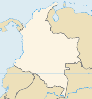
Wikipedia Galeras = http://en.wikipedia.org/wiki/Galeras
Mount Semeruquote:Volcano erupts in Indonesia
The tallest volcano on Indonesia's Java island has erupted, spewing smoke and ash high into the sky and coating a nearby town in black dust, an official says.
The 3,676-metre Mount Semeru burst into life shortly after midnight on Friday (local time), but officials said it posed no danger to people living in the area, 35 kilometres south-east of Lumajang.
"We recorded that it erupted after midnight on Friday, but luckily we have had rains so the ash isn't causing serious respiration problems for the residents," volcanologist Agus Budianto said.
Winds had also helped to carry the harmful debris away from the most populated areas nearby, he said.
Budianto said there had been no evacuation order but authorities were monitoring the eruption closely for signs of lethal heat clouds.
Semeru in 1985
The Indonesian archipelago sits on the seismically active Pacific Ring of Fire where continental plates collide, and is home to about 130 active volcanoes.

De Semeru is hier niet echt nieuws, pufjes en as doet die vulkaan vrijwel iedere maand eens, alleen nu een tikkie erger dus.
http://www.depers.nl/vide(...)kaanuitbarsting.html
welke vulkaan is dit? Kan het filmpje wel bekijken, maar heb geen geluid.
Aan de tekens te zien, ziet het eruit als Japans ofzo?
Tis wel een recente, want het filmpje is van vandaag.
welke vulkaan is dit? Kan het filmpje wel bekijken, maar heb geen geluid.
Aan de tekens te zien, ziet het eruit als Japans ofzo?
Tis wel een recente, want het filmpje is van vandaag.
Sakura Jima, pin me niet vast op de spelling maar dat wordt er gezegd, vanmorgen in alle vroegte uitgebarsten zeggen ze.quote:Op dinsdag 10 maart 2009 16:22 schreef Frutsel het volgende:
http://www.depers.nl/vide(...)kaanuitbarsting.html
welke vulkaan is dit? Kan het filmpje wel bekijken, maar heb geen geluid.
Aan de tekens te zien, ziet het eruit als Japans ofzo?
Tis wel een recente, want het filmpje is van vandaag.
http://volcanism.wordpres(...)tion-at-sakura-jima/
quote:Eruption at Sakura-jima 10 March 2009
Posted by volcanism in Japan, Sakura-jima, activity reports, eruptions.
Tags: Japan, Sakura-jima, volcanic activity reports, volcanic eruptions
trackback
The highly active stratovolcano Sakura-jima in southern Japan has erupted, say English-language news reports this morning. There are reports of an explosion at 05:22 local time, lava flows, an eruption column of up to 1.2km altitude, and volcanic debris projected to distances of up to 2km from the crater.
The Tokyo VAAC has issued a volcanic ash advisory for the volcano, but no aviation colour code alert has yet been issued. The Japan Meteorological Agency has issued a warning to local residents. The BBC has a video of the current activity.
[ Bericht 38% gewijzigd door kahaarin op 10-03-2009 16:47:35 ]
be nice or go away
The Big Picture: Explosion
An undersea volcano erupts sending plumes of steam, ash and smoke up to 100 metres into the air, on 18 March 2009 off the coast of Nuku'Alofa, Tonga. The volcano, which is situated approximately six miles off of the main Tongan island of Tongatapu, is one of around 36 undersea volcanoes clustered in the area.
Photo: Dana Stephenson/Getty Images
[ Bericht 15% gewijzigd door -CRASH- op 19-03-2009 19:09:43 ]

An undersea volcano erupts sending plumes of steam, ash and smoke up to 100 metres into the air, on 18 March 2009 off the coast of Nuku'Alofa, Tonga. The volcano, which is situated approximately six miles off of the main Tongan island of Tongatapu, is one of around 36 undersea volcanoes clustered in the area.
Photo: Dana Stephenson/Getty Images


[ Bericht 15% gewijzigd door -CRASH- op 19-03-2009 19:09:43 ]
<a href="http://www.vwkweb.nl/" rel="nofollow" target="_blank">[b]Vereniging voor weerkunde en klimatologie[/b]</a>
<a href="http://www.estofex.org/" rel="nofollow" target="_blank">[b]ESTOFEX[/b]</a>
<a href="http://www.estofex.org/" rel="nofollow" target="_blank">[b]ESTOFEX[/b]</a>
7.9 quake + tsunami warning in datzelfde gebied bij Tonga 
Toeval?
Aardbevingen #7: 7.9 TONGA - Tsunami Warning
Toeval?
Aardbevingen #7: 7.9 TONGA - Tsunami Warning
quote:Vulkaanuitbarsting Tonga
Een zware aardbeving en vulkaanuitbarsting hebben donderdag en vrijdag voor opschudding gezorgd in Tonga en de omliggende eilandengroepen op ongeveer 2000 kilometer ten noordoosten van Nieuw-Zeeland.
In de archipel van ongeveer 170 eilanden gingen scholen en overheidsgebouwen dicht nadat er was gewaarschuwd voor een tsunami. Het alarm werd enkele uren later ingetrokken.
Op het hoofdeiland van Tonga werd geen schade gemeld. Wel is het onbewoonde eiland Hunga Ha'apai, op 63 kilometer van de Tongaanse hoofdstad Nuku'alofa, verwoest. ,,Er is geen levend wezen meer te bekennen, het is bedekt met een zwarte aslaag'', aldus de Tongaanse journalist George Lavaka. Hij bezocht het bountyeiland op het moment van de zware uitbarsting met een groep wetenschappers, overheidsfunctionarissen en toeristen om te kijken wat de gevolgen zijn van eerdere vulkaanuitbarstingen deze week ,,Er zijn alleen nog zwarte stompjes waar eerst kokospalmen stonden'', aldus de journalist in Australische media. De groep snelde weg van het eiland en zag veel dode vissen en vogels in zee.
Tonga ligt op de zogeheten Ring van Vuur waar continentale platen rond de Grote Oceaan op elkaar botsen waardoor geregeld vulkaanuitbarstingen en aardbevingen plaatsvinden. De vulkaan op Hunga Ha'apai heeft een opening op het eiland en een op ongeveer 100 meter verderop in zee, die vooral in het water spuwde. Boven beide openingen waren vrijdag dikke rookwolken te zien, die tot zeker 20 kilometer de lucht in gingen.

Foto's en Filmpjequote:De onderzeese aardbeving bij Tonga, de eilandengroep bij Nieuw-Zeeland in de Stille oceaan heeft nauwelijks schade aangericht. Daar werd gisteren wel voor gevreesd, nadat direct een tsunami-waarschuwing werd gegeven. Maar de gevolgen bleken niet ernstig.
De zeespiegel was maar een paar centimeter gestegen door een kleine golf. De beving had een kracht van 7.9 op de schaal van Richter.
De waarschuwing zorgde wel voor paniek op Tonga. "Veel mensen renden rond nadat ze de waarschuwing hadden gehoord", staat op een Nieuw-Zeelandse site. In totaal heeft de vloedgolf-waarschuwing een uur geduurd.
Het epicentrum van de aardbeving lag 209 kilometer uit de kust van Nuku'alofa, op Tonga en op een diepte van 10 kilometer.
Tonga ligt op de zogeheten 'Ring van Vuur'. Een lijn die rond de Stille oceaan loopt en waar veel vulkanen actief zijn. De afgelopen weken rommelt het flink.
Vulkaanuitbarsting
Gisteren barstte ook een onderwatervulkaan uit bij Tonga op 10 kilometer van de hoofdstad. De rook- en aspluim was 7 kilometer hoog, maar werd al snel door de wind verspreid.
De as in de lucht is gevaarlijk voor vliegtuigen. Air New Zealand heeft al enkele toestellen laten omvliegen.
"Een onderwatervulkaan is niet ongewoon voor dit gebied", zegt het hoofd van de geologische dienst van Tonga. "We weten dat het ieder moment kan gebeuren."
Aardschokken
Volgens bewoners van het kustgebied begonnen de uitbarstingen maandagochtend na een serie stevige aardschokken.
De Tonga-archipel maakt deel uit van de vuurring, een vulkanische zone van Chili via Alaska en Vanuatu naar Congo.
Gelukkig valt het mee, vind ik toch wel fijner kijken, mooie beelden trouwens, die paniek omdat de aswolk zo snel dichterbij komt is ook wel geinig.quote:
be nice or go away
VOLCANIC CLOUDS:
Alaska's Mt. Redoubt volcano has erupted no fewer than 19 times since March 22nd, and several of the larger blasts have hurled plumes of ash and gas into the lower stratosphere. The GOME-2 (Global Ozone Monitoring Experiment) sensor onboard Europe's MetOp-A satellite has been tracking Redoubt's sulfur dioxide clouds, colored red in this 5-day animation:
The sequence begins on March 25th and ends on the 29th. One cloud has just crossed North America en route to Europe. A second cloud is leaving Alaska on the same east-west track. The last time an Alaskan volcano blew its top (Kasatochi in 2008), clouds like these caused fantastic sunsets around the northern hemisphere. More could be in the offing. If you live along the SO2 ground track, keep an eye on the twilight sky for signs of Redoubt--and stay tuned for updates.
BRON: Spaceweather.com
<a href="http://www.vwkweb.nl/" rel="nofollow" target="_blank">[b]Vereniging voor weerkunde en klimatologie[/b]</a>
<a href="http://www.estofex.org/" rel="nofollow" target="_blank">[b]ESTOFEX[/b]</a>
<a href="http://www.estofex.org/" rel="nofollow" target="_blank">[b]ESTOFEX[/b]</a>
@CRASH
heb je bericht ff in het topic van de Redoubt gegooid! Thx!
BREAKING: Uitbarsting Mt.Redoubt (Alaska)
heb je bericht ff in het topic van de Redoubt gegooid! Thx!
BREAKING: Uitbarsting Mt.Redoubt (Alaska)
Er staat een update met foto op de bovenstaande link:
quote:Brian Whittaker
Image taken:
Mar. 25, 2009
Location:
Airborne at 39,000 feet over Mt Robson, highest point in the Canadian Rocky Mountains (NE British Columbia)
Details:
As I flew past this brownish cloud of what looked to me like volcanic ash, I remembered that Alaska's Mt Redoubt was upstream from my location. Thanks to the SpaceWeather.com published SO2 animation, I was able to confirm my sighting. Volcanic ash has a certain look which can be rather rusty from certain angles with the sun low in the sky.

be nice or go away
http://www.laht.com/article.asp?ArticleId=331248&CategoryId=14094quote:[b]Locals Evacuated After Eruption of Chile’s Llaima Volcano
SANTIAGO – The reactivation of the Llaima volcano some 600 kilometers (323 miles) south of Santiago sparked the declaration of a red alert and orders to evacuate local residents, the regional press said.
The volcano, dormant for half a year, erupted again Friday night with explosions and the spewing forth of incandescent material that reached some 600 meters (1,967 feet) above the crater, which is 3,210 meters (10,524 feet) high.
Authorities ordered the closure of Conguillio National Park where the Llaima volcano is located and evacuated the 14 people who were inside it, including five construction workers, seven park guards and two tourists, one a Spaniard and the other Chilean.
The daily El Mercurio also said that three people have been evacuated from the ski resort of Las Araucarias.
The regional government of La Araucania also declared a red alert in eight nearby towns, from which it hopes to evacuate 70 people away from the expected shower of ash and debris.
Regional emergency services that met Saturday in Temuco and were scheduled to meet later in Cherquenco also decided to do a census of domestic animals in the area and analyze the kind of ash pouring from the volcano.
Llaima, considered one of the most active volcanos in South America, is located some 76 kilometers (47 miles) northeast of Temuco, capital of the La Araucania region, and at its feet are the towns of Curacautin, Cherquenco and Melipeuco.[/b]
http://thestar.com.my/news/story.asp?file=/2009/4/5/apworld/20090405093719&sec=apworldquote:Llaima volcano spews lava, ash in southern Chile
SANTIAGO, Chile (AP) - One of Chile's most active volcanos is spewing lava and ash again, prompting evacuations and landslide warnings.
The national emergency department is reporting that the 10,250-foot-high (3,125-meter-high) Llaima volcano has hurled explosive materials up to 600 meters (650 yards) above the crater and issued a flow of lava more than 1,000 yards (meters) long.
A statement from the department Saturday noted that villagers were evacuated as a precaution after officials conducting flyovers saw snow melting around the crater, "which means a high risk of mudslides ... (and) the possible rising of the Calbuco River."
The volcano is located 380 miles (600 kilometers) south of the capital, Santiago.
Its last big eruption was in January 2008. -AP
Hier ook een filmpje.

Op zaterdag 15 augustus 2009 23:05 schreef eer-ik het volgende:
Ik vind je sig nogal denigrerend.
Ik vind je sig nogal denigrerend.
Pff schrok even maar gelukkig bezoekt m'n vriend nu de Vulkaan in Pucon en ligt die redelijk ver van Vulkaan Llaima.:o
People demand freedom of speech as a compensation
for the freedom of thought which they seldom use.
for the freedom of thought which they seldom use.
mee lees post
DeLuna vindt me dik ;(
Op zondag 22 juni 2014 12:30 schreef 3rdRock het volgende:
pas als jullie gaan trouwen. nu ben je gewoon die Oom Rubber die met onze mama leuke dingen doet :)
Op zondag 22 juni 2014 12:30 schreef 3rdRock het volgende:
pas als jullie gaan trouwen. nu ben je gewoon die Oom Rubber die met onze mama leuke dingen doet :)
Dat is inderdaad geluk!quote:Op zondag 5 april 2009 13:00 schreef Ad_rem het volgende:
Pff schrok even maar gelukkig bezoekt m'n vriend nu de Vulkaan in Pucon en ligt die redelijk ver van Vulkaan Llaima.:o
Dubbel denk ik, want de Villarrica is echt een mooie vulkaan. Perfecte vorm, mooie omgeving, bijna altijd met rookpluim, etc!
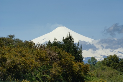
Op zaterdag 15 augustus 2009 23:05 schreef eer-ik het volgende:
Ik vind je sig nogal denigrerend.
Ik vind je sig nogal denigrerend.
De unieke fuana op de Galapagos eilanden is in gevaar. Vulkaan La Cumbre is uitgebarsten en talloze dieren worden bedreigd door de lavastroom die naar zee stroomt.quote:"La Cumbre" bedroht Tierwelt auf Galápagos-Inseln
Die einzigartige Fauna auf den Galápagos-Inseln ist in Gefahr: Der Vulkan "La Cumbre" ist ausgebrochen, zahlreiche Tiere sind durch die ins Meer fließende Lava bedroht. Menschen sind bislang nicht zu Schaden gekommen.
http://www.spiegel.de/wissenschaft/natur/0,1518,618703,00.htmlquote:Quito - Ein Vulkanausbruch auf den Galápagos-Inseln im Ostpazifik bedroht die einzigartige Tierwelt. Der Vulkan La Cumbre auf der Insel Fernandina speie seit Samstag Lava, Gas und Rauch, teilte die Nationalparkbehörde mit. Anwohner auf der Nachbarinsel Isabela seien nicht betroffen, die ins Meer fließende Lava könne aber Leguane, Wölfe und weitere Tiere schädigen. La Cumbre brach zuletzt im Mai 2006 aus.
Das zu Ecuador gehörende Galápagos-Archipel ist für seine einmalige Tier- und Pflanzenwelt bekannt. Einige Arten wie zum Beispiel die Galápagos-Riesenschildkröte kommen nur auf den mehr als 114 Inseln vor.
Auch in Alaska hat ein Vulkanausbruch Anfang April die Natur gefährdet. Ein Strom von Schmelzwasser und heißen Felsbrocken wälzte sich durch das Tal des Drift River und erreichte das gleichnamige Ölterminal des Chevron-Konzerns.
Ausbruch vereitelte den Plan, die dort gelagerten 23,9 Millionen Liter Öl vorsorglich in Sicherheit zu bringen. Ein Tanker musste unverrichteter Dinge wieder zurückkehren.
Op zaterdag 15 augustus 2009 23:05 schreef eer-ik het volgende:
Ik vind je sig nogal denigrerend.
Ik vind je sig nogal denigrerend.

quote:La Cumbre Volcano on Isla Fernandina remained active on April 12, 2009, as the Moderate Resolution Imaging Spectroradiometer (MODIS) on NASA’s Aqua passed overhead. According to the U.S. Air Force Weather Agency, the volcano experienced continuous ash and steam emissions.
Compared to the image acquired the previous day, this image shows a much smaller red-outlined hotspot of anomalously warm surface temperatures. The plume has spread over a wider area, and now travels primarily toward the southwest. A segment of the plume appears north of Isla Fernandina, suggesting a shift in wind direction at some point. Compared to the clouds over Isla Isabela and Isla Fernandina, the volcanic plume is slightly darker and thinner, with less distinct margins.
CHILE’S CHAITÉN VOLCANO CONTINUES TO RUMBLE
http://www.patagoniatimes(...)INUES-TO-RUMBLE.html
quote:Chaitén erupted last May for first time in recorded history
Southern Chile’s Chaitén volcano has produced a “continual and sustained increase” in seismic activity in recent days, raising concerns of yet another possible eruption, the National Geologic and Mining Service (SERNAGEOMIN) reported Wednesday.
Since April 7 monitors have recorded an average of 16 small quakes per day, some of them as strong as 4.5 degrees on the Richter scale. Previously the volcano produced an average of 10 daily tremors.
“This could provoke eventual explosions and ash flows that cold affect the adjacent valleys,” said SERNAGEOMIN.
Chaitén erupted last May for the first time in recorded history, sending up a massive plume of ash that at one point reached as far as Buenos Aires, Argentina (PT, May 2, 2008). The Region X volcano, located some 1,200 kilometers south of Santiago, buried the nearby town of Chaitén and forced the evacuation of its approximately 8,000 residents.
Government authorities decided earlier this year not to rebuild Chaitén – which was also badly damaged by floods – on its original location. A decision was made instead to relocate the town to nearby Santa Barbara, where construction on the “new Chaitén” is currently underway.
Chile has one of the most active volcanic chains in the world. Just last week another Chilean volcano, Region IX’s Llaima, erupted, releasing a 7,000-meter-high column of smoke and ash and producing several dramatic lava flows (PT, April 6).
Llaima, one of the country’s most active volcanoes, has erupted several times since mid 2007. In 2008 it brought in the New Year with a spectacular eruption, coughing up huge plumes of glowing lava. Exactly six months later Llaima awoke yet again.
http://www.patagoniatimes(...)INUES-TO-RUMBLE.html
Op zaterdag 15 augustus 2009 23:05 schreef eer-ik het volgende:
Ik vind je sig nogal denigrerend.
Ik vind je sig nogal denigrerend.
http://itn.co.uk/news/9d63253fd90903df570149b89bbde3bf.htmlquote:A volcano in the Galapagos Islands has rumbled into life again a week after it erupted.
The Geophysical Institute of the National Polytechnic School reported 43 thermal alerts and said that satellite images revealed a column of gas that extended more than 60 miles (100 kilometres) west of the islands, indicating an increase in volcanic activity.
The La Cumbre volcano began spewing lava, gas and smoke on Fernandina Island on Saturday after four years of inactivity.
Experts are concerned the activity may be taking a toll on the islands' famed wildlife and will launch a study on the environmental impact of the volcano in the coming days.
Charles Darwin developed his theory of evolution after studying the unique animal populations of the Galapagos Islands - and they have attracted biologists and conservationists ever since.
The islands are scarcely populated, but the United Nations last year said the pristine environment of the Pacific island chain was in danger due to booming tourism.
Op zaterdag 15 augustus 2009 23:05 schreef eer-ik het volgende:
Ik vind je sig nogal denigrerend.
Ik vind je sig nogal denigrerend.
images of Kilauea Volcanoquote:Wednesday, May 13, 2009 7:43 AM HST (Wednesday, May 13, 2009 17:43 UTC)
This report on the status of Kilauea volcanic activity, in addition to maps, photos, and webcam images (available using the menu bar above), was prepared by the USGS Hawaiian Volcano Observatory (HVO). Hawai`i Volcanoes National Park status can be found at http://www.nps.gov/havo/ or 985-6000. Hawai`i County Viewing Area status can be found at 961-8093.
KILAUEA VOLCANO (CAVW #1302-01-)
19°25'16" N 155°17'13" W, Summit Elevation 4091 ft (1247 m)
Current Aviation Color Code: ORANGE
Current Volcano Alert Level: WATCH
Activity Summary for past 24 hours: Glow from the Halema`uma`u vent continues to be visible. Lava from east rift zone vents continues to flow through tubes to the coast and is entering the ocean at two locations west of Kalapana. Sulfur dioxide emission rates from the Halema`uma`u and Pu`u `O`o vents remain elevated.
Past 24 hours at Kilauea summit: A molten lava pool remains near the base of the cavity deep below the floor of Halema`uma`u Crater and is producing a visible, but decreasing in intensity, glow (recorded by both webcams pointed at it - see our new "Webcams" link at hvo.wr.usgs.gov); the decreasing glow suggests that the surface of the lava pool may be receding.
This morning, the gas plume rises about 600 m (2,000 ft) above the Halema`uma`u Crater rim and moves to the west; GOES-WEST imagery shows the plume continuing to the WNW into the east flank of Mauna Loa where it is diverted southward. Sulfur dioxide emission rates remain elevated and variable; the most recent rate measurement was 1,200 tonnes/day on May 12, compared to the 2003-2007 average rate of 140 tonnes/day. Small amounts of mostly ash-sized tephra continue to be produced consisting mostly of Pele's hair, irregular pieces of vesicular glass, and a few hollow spherules. Gas-rushing and rockfall sounds were again heard during the morning collection routine.
Tremor levels remain at moderate values. Two earthquake were located beneath the south summit, five on south flank faults, and only one earthquake was located in the area about 4 km (3 mi) northwest of Halema`uma`u Crater. The number of RB2S2BL earthquakes were within background levels.
The network of tiltmeters at Kilauea's summit recorded no significant tilting. The GPS network (less sensitive than the tiltmeter network) has recorded about 1 cm of contraction across the caldera over the past 3 months.
Past 24 hours at the middle east rift zone vents and flow field: Magma continues to degas through Pu`u `O`o Crater before erupting from vents to the east. The most recent measurement was 1,400 tonnes/day measured on May 8, compared to the 2003-2007 average of about 1,700 tonnes/day. No incandescence was recorded within the crater overnight.
The tiltmeter on the north flank of Pu`u `O`o stopped reporting to HVO just before 8 am Saturday; technicians will resolve the problem later this week when helicopter time becomes available. GPS receivers on opposite sides of the crater have documented about 1.5 cm of contraction over the past month and more than 5 cm over the past 3 months. Seismic tremor levels near the eruptive vents are low and steady.
Lava from the TEB vent and the rootless shield complex flows through tubes to the ocean at Waikupanaha and Kupapa`u. MODIS imagery showed ocean entry plumes moving southwest along the coast yesterday afternoon from lava continuing to enter the ocean. Weak thermal anomalies were present on the coastal plain through this morning in GOES-WEST imagery; anomalies of this intensity are usually not associated with active surface flows but rather inactive, cooling flows.
HAZARD ALERT: The lava delta and adjacent areas both inland and out to sea are some of the most hazardous areas on the flow field. Frequent delta/bench collapses give little warning, can produce hot rock falls inland and in the adjacent ocean, and can produce large but local waves. The steam plume produced by lava entering the ocean contains fine lava fragments and an assortment of acid droplets that can be harmful to your health. The rapidly changing conditions near the ocean entry have been responsible for many injuries and a few deaths.
Maps, photos, webcam views, and other information about Kilauea Volcano are available at
http://volcano.wr.usgs.gov/kilaueastatus.php

Pauze in vulkanisme veranderde de aarde in een sneeuwbal
Een lange onderbreking in vulkanisme heeft er 2,45 miljard jaar geleden toe geleid dat de aarde veranderde in één grote sneeuwbal. De 200 miljoen jaar durende periode zonder vulkaanuitbarstingen was mogelijk het gevolg van een onderbreking in de plaattektoniek, het geschuif van stenige continenten over een stroperige aardmantel dat het aanzien van de aarde bepaalt.
Mount St. Helens.
Foto USGS De vulkaanpauze viel samen met het ontstaan van een zuurstofrijke atmosfeer. Dat concluderen Amerikaanse en Australische aardwetenschappers uit een inventarisatie van de ouderdom van stukken aardkorst en vulkanische afzettingen, verspreid over de hele wereld (Earth and Planetary Science Letters, 21 april 2009).
De studie onder leiding van Kent Condie (New Mexico Tech) laat zien dat er tussen 2,45 miljard jaar en 2,2 miljard jaar geleden nauwelijks gesteente ontstond uit vulkanen of door de hoge druk en temperatuur die ontstaat als twee aardplaten op elkaar botsen. Mogelijk was het binnenste van de aarde zo warm en vloeibaar dat er soms onvoldoende grip was om schollen over het aardoppervlak voort te stuwen.
Volgens Condie resulteerde een drastische verlaging in de uitstoot van gassen uit vulkanische erupties ook in een sterke afname van het CO2-gehalte in de atmosfeer. De aarde koelde sterk af en raakte met sneeuw en ijs bedekt. Zonder vulkanische uitbarstingen was er ook minder ijzeruitstoot, waardoor zuurstof niet werd vastgelegd in ijzeroxiden, maar vrijkwam in de atmosfeer. Het gebrek aan ijzer zou ook een wereldwijd hiaat verklaren in de vorming van banded iron formations, afwisselende lagen van ijzerrijk en ijzerarm gesteente.
Condie baseert de datering van stenen op het mineraal zirkoon. De mate waarin het daarin aanwezige uranium tot lood is vervallen, is een maat voor de ouderdom ervan.
nrc
Vulkaan Galeras komt tot uitbarsting in Colombia
In Colombia is de vulkaan Galeras vandaag om 7.18 uur (14.18 uur Belgische tijd) tot uitbarsting gekomen. Dat meldt het Colombiaanse geologische instituut Ingeominas. De vulkaan ligt in het departement Narino in het zuiden van het land, aan de grens met Ecuador.
Vijfde uitbarstiing
Wegens gebeurtenissen "met explosief karakter" ging het alarmpeil op rood staan. Dat betekent een uitbarsting "die zeer nabij is of al bezig is", verduidelijkt Ingeominas. Het gaat om de vijfde uitbarsting van de Galeras in minder dan anderhalf jaar. De laatste uitbarsting dateert van eind april. Die bleef zonder gevolg voor de zowat 7.000 inwoners uit de omgeving. In 1993 kwamen negen personen om bij een uitbarsting van de Galeras. De vulkaan ligt in het Andesgebergte en reikt tot 4.270 meter hoogte.
Geen slachtoffers
Bij de uitbarsting van vandaag zijn er geen slachtoffers gevallen. Ook is er geen schade aangericht. Er is alleen vulkanische as neergevallen in de gemeente Sandona. (belga/ep)

Hires foto
Sarychev Peak Volcano eruption, Kuril Islands
quote:International Space Station Imagery
ISS020-E-009048 (12 June 2009) --- Sarychev Peak Volcano eruption, Kuril Islands, is featured in this image photographed by an Expedition 20 crew member on the International Space Station. A fortuitous orbit of the International Space Station allowed the astronauts this striking view of Sarychev volcano (Russia's Kuril Islands, northeast of Japan) in an early stage of eruption on June 12, 2009. Sarychev Peak is one of the most active volcanoes in the Kuril Island chain and is located on the northwestern end of Matua Island. Prior to June 12, the last explosive eruption had occurred in 1989 with eruptions in 1986, 1976, 1954, and 1946 also producing lava flows. Ash from the June 2009 eruption has been detected 2407 kilometers ESE and 926 kilometers WNW of the volcano, and commercial airline flights are being diverted away from the region to minimize the danger of engine failures from ash intake. This detailed photograph is exciting to volcanologists because it captures several phenomena that occur during the earliest stages of an explosive volcanic eruption. The main column is one of a series of plumes that rose above Matua Island (48.1 degrees north latitude and 153.2 degrees east longitude) on June 12. The plume appears to be a combination of brown ash and white steam. The vigorously rising plume gives the steam a bubble-like appearance; the surrounding atmosphere has been shoved up by the shock wave of the eruption. The smooth white cloud on top may be water condensation that resulted from rapid rising and cooling of the air mass above the ash column, and is probably a transient feature (the eruption plume is starting to punch through). The structure also indicates that little to no shearing winds were present at the time to disrupt the plume. Another series of images, acquired 2-3 days after the start of eruptive activity, illustrate the effect of shearing winds on extent of the ash plumes across the Pacific Ocean. By contrast, a cloud of denser, gray ash -- most probably a pyroclastic flow -- appears to be hugging the ground, descending from the volcano summit. The rising eruption plume casts a shadow to the northwest of the island (bottom center). Brown ash at a lower altitude of the atmosphere spreads out above the ground at upper right. Low-level stratus clouds approach Matua Island from the east, wrapping around the lower slopes of the volcano. Only about 1.5 kilometers of the coastline of Matua Island (upper center) can be seen beneath the clouds and ash.
<a href="http://www.vwkweb.nl/" rel="nofollow" target="_blank">[b]Vereniging voor weerkunde en klimatologie[/b]</a>
<a href="http://www.estofex.org/" rel="nofollow" target="_blank">[b]ESTOFEX[/b]</a>
<a href="http://www.estofex.org/" rel="nofollow" target="_blank">[b]ESTOFEX[/b]</a>
Vulcanic Sunsets
Sky watchers in Europe should be alert for volcanic sunsets.
A mass of sulfur dioxide from Russia's Sarychev Peak volcano is swirling through the stratosphere over the North Atlantic and it appears poised to move over land during the next 24 hours.
movie by the GOME-2 sensor onboard Europe's
MetOp-A satellite shows the progress of the plume
Sky watchers in Europe should be alert for volcanic sunsets.
A mass of sulfur dioxide from Russia's Sarychev Peak volcano is swirling through the stratosphere over the North Atlantic and it appears poised to move over land during the next 24 hours.
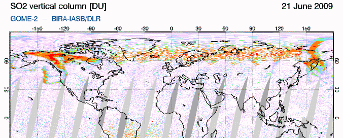
movie by the GOME-2 sensor onboard Europe's
MetOp-A satellite shows the progress of the plume
<a href="http://www.vwkweb.nl/" rel="nofollow" target="_blank">[b]Vereniging voor weerkunde en klimatologie[/b]</a>
<a href="http://www.estofex.org/" rel="nofollow" target="_blank">[b]ESTOFEX[/b]</a>
<a href="http://www.estofex.org/" rel="nofollow" target="_blank">[b]ESTOFEX[/b]</a>


On June 12, 2009, Sarychev Peak on the Kuril Islands’ Ostrov Matua experienced a spectacular eruption. The event left behind a changed island. Acquired by the Advanced Spaceborne Thermal Emission and Reflection Radiometer (ASTER) on NASA’s Terra satellite, these images of Ostrov Matua show the island shortly after the eruption on June 30, 2009 (top), and two years before on May 26, 2007 (bottom).
In these false-color images, vegetation appears red, water appears dark blue, and clouds, water vapor and ice all appear white. Volcanic rock, including old lava flows and debris from the recent eruption, ranges from gray to dark brown.
The most striking difference between these two images is the gray coating on the northwestern half of the island in June 2009. While vegetation on the rest of the island appears lush, volcanic debris—probably a mixture of pyroclastic flows and settled ash—covered virtually all the vegetation on the northwestern end. A close look at the top image also reveals that the recent volcanic activity appears to have expanded the island’s coastline on the northwestern end.
Another difference between the images relates to snow cover. In the image from May 2007, snow spreads over much of the island, although the snow alternates with snow-free ground. The vegetation is pinkish-gray, suggesting the spring thaw is still underway. The complete lack of snow in 2009 may result from a combination of a difference in season and volcanic activity having melted or covered any lingering snow.
Dankzij die quake dus?quote:Authorities raise Mt. Talang alert level to highest
The vulcanology and disaster mitigation office in West Sumatra has raised the alert status for Mt. Talang to the highest level following a 6.9-magnitude earthquake and a series of aftershocks that struck the province.
Vulcanologist Dalipa Marjusi said Tuesday the tremors had sparked a volcanic earthquake and temblors, although eruption of the volcano remained undetected.
“Since Sunday’s earthquake we have recorded 1,600 volcanic quakes and 700 tectonic quakes, but only 23 of them were felt,” Dalipa said.
Fog has blanketed the summit of the 2,597-meter volcano for the last two days, making it difficult to see ash or lava that might be erupting from its crater.
The volcano last spewed hot ash last April.
A seven-strong team from the directorate general of vulcanology and disaster mitigation have arrived in Padang from Bandung to monitor the volcano’s activities.
Zal morgenochtend eens een kaartje pakken om te zien hoe groot de afstand is.. het is al negen uur hier en ik heb al een dag barstende koppijn, dus ik ga lekker slapen (alweer)..quote:
Ik ben benieuwd wat er gaat gebeurenquote:
Ik ben illegaal!
Op woensdag 1 december 2010 16:07 schreef honkeytonk het volgende:Ik denk zelfs dat ze achter de schermen een fantopic over mij hebben geopend :Y
Op woensdag 1 december 2010 16:07 schreef honkeytonk het volgende:Ik denk zelfs dat ze achter de schermen een fantopic over mij hebben geopend :Y
Het kaartje met de aardbeving van eerder deze maand (teruggeschaald naar een 6.6 van een 6.9 overigens) en de Talang vulkaan op het vasteland van West Sumatra. Als je wil weten waar dit kaartje is gesitueerd, klik dan even verder, zodat je een kaartje van Indonesie krijgt met deze vulkaan geselecteerd.
Het bolletje is de aardbeving, het driehoekje de vulkaan met de actuele status vermeld
Actief kaartje en status van de vulkaan:
Changes in activity for Gunung Talang

Het bolletje is de aardbeving, het driehoekje de vulkaan met de actuele status vermeld
Actief kaartje en status van de vulkaan:
Changes in activity for Gunung Talang
quote:Phivolcs notes 3 minor ash explosions at Mayon
More At least three minor ash explosions were recorded at Mayon Volcano in Bicol early Tuesday, prompting authorities to appeal anew to the public to stay away from the volcano's danger zones.
The Philippine Institute of Volcanology and Seismology (Phivolcs) said the three minor ash explosions were recorded at 5:37 a.m.
"These events lasted for about three minutes. The explosions produced a brownish ash column that rose about 700 meters above the crater and drifted to the southwest," it said in its advisory.
On the other hand, Phivolcs said a "faint crater glow" was observed Monday night.
Radio dzXL reported Tuesday noon that the Phivolcs has started coordinating with the Albay Public Safety and Disaster Management Office to prepare for possible evacuation of residents.
The Phivolcs said that in the last 24 hours, the seismic network recorded 11 volcanic earthquakes.
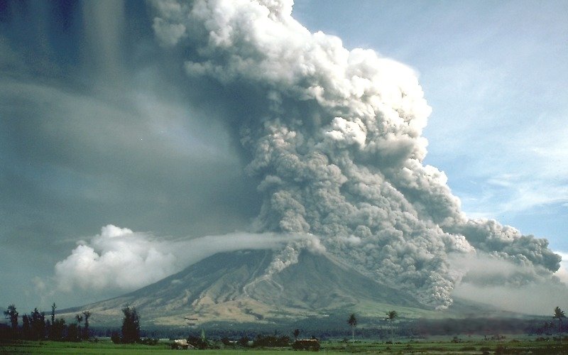
uitbarsting vulkaan Mayon in 1984
Mayon Vulkaan
quote:Seismologen vrezen nu uitbarsting vulkaan op Sumatra
Seismologen vrezen dat de aardbeving en mogelijke naschokken voor de kust van Sumatra kunnen leiden tot vulkaanuitbarstingen. Op Sumatra liggen drie grote vulkanen: Merapi, Talang en Tandikat. Op Sumatra, een van de grootste eilanden ter wereld, leven meer dan veertig miljoen mensen.
is het wel eens voorgekomen eigenlijk dat vulkaanuitbarstingen getriggered werden door aardbevingen?quote:
[b]Op maandag 6 september 2010 00:28 schreef tong80 het volgende:[/b]
GVD Wat moet jij een trotse vader zijn :)
:P
GVD Wat moet jij een trotse vader zijn :)
:P
Zeker wel... de meeste vulkaanuitbarstingen gaan gepaard met aardbevingen. Vaak zijn die kleine bevingen juist de voorbode. Maar een grotere kan zeker een vulkaan triggeren, maar tis niet zo dat het altijd zo is.
In maart 2009 brak er een vulkaan open in de Stille Oceaan bij Tonga... toevallig was die dag ervoor een quake van 7.9 geweest
Vulkaanuitbarsting in Grote Oceaan
Maar geen idee of het in dit geval echt wetenschappelijk bewezen is dat één het gevolg is van het andere.
In maart 2009 brak er een vulkaan open in de Stille Oceaan bij Tonga... toevallig was die dag ervoor een quake van 7.9 geweest
Vulkaanuitbarsting in Grote Oceaan
Maar geen idee of het in dit geval echt wetenschappelijk bewezen is dat één het gevolg is van het andere.

quote:Fresh lava domes fill most of the 10,000-year old caldera of Chaitén volcano. Dome 1 began forming in May of 2008, when Chaitén erupted for the first time in written history. Dome 2 began growing later, in the fall of 2008. Shifting winds were blowing the plume of ash and steam to the southeast, revealing the northern and western sides of the two domes (the southern side of Dome 1 was visible on September 27, 2009).
According to Servicio Nacional de Geología y Minería [SERNAGEOMIN—the Chilean National Geological and Mining Service (translated by The Volcanism Blog)], the dome complex is currently growing steadily. Active lava domes are extremely unstable and dangerous. They are often steep-sided, composed of weak rocks, and prone to frequent collapses. A lava dome collapse can release one type of pyroclastic flow, a fast-moving landslide composed of extremely hot rocks, ash, and gas.
quote:Op donderdag 1 oktober 2009 16:14 schreef Againzender het volgende:
[..]
is het wel eens voorgekomen eigenlijk dat vulkaanuitbarstingen getriggered werden door aardbevingen?
quote:Large earthquakes may trigger volcanic eruptions
10 December 2008
Large earthquakes can trigger volcanic eruptions up to a year later and up to 500 kilometres away from their epicentres, according to new research
Parinacota volcano, Chile
The findings suggest that volcanoes in regions of high earthquake activity should be more closely monitored after a large earthquake has struck.
Sebastian Watt and colleagues Professor David Pyle and Dr Tamsin Mather from the University of Oxford analysed continuous records of earthquakes and volcanic eruptions from southern Chile going back to 1850. Records since then include 206 eruptions from 25 different volcanoes.
Two major earthquakes in 1906 and 1960 led to a large rise in the number of volcanic eruptions in the year following each earthquake. Before the end of 1907, seven volcanoes erupted and by the end of 1961 after the 1960 earthquake, there were six eruptions. On average, the researchers say, there are 1.32 eruptions every year in this region.
Watt and his colleagues also studied data from records that weren't continuous, and linked two large earthquakes in 1751 and 1835 to an increase in volcanic activity in the area. The work is due to be published in the journal Earth and Planetary Science Letters.
'We had access to data going back to 1550, but decided not to include large chunks of it because it wasn't continuous and therefore wasn't completely reliable,' says Watt.
'This could also be happening in other areas with
high earthquake and volcanic activity, like Indonesia and Alaska.'
Sebastian Watt, University of Oxford
Charles Darwin also noticed that volcanoes to the north of the 1835 earthquake in Concepción, Chile were 'in great activity' a few days after the earthquake and the whole of the volcanic chain was active for the rest of the year.
Despite Darwin's observations, linking large earthquakes with volcanic eruptions is a fairly young science and many scientists have been sceptical.
'Previous studies looked at global datasets, where it's very difficult to elucidate a link on a timescale longer than a few days,' says Watt.
Looking at the detail
Watt and his team took a different approach. They are the first to look at a longer timescale and focus on a specific area. Along the continental margin - where the oceanic crust meets the continental crust - Chile has some of the largest earthquakes in the world with magnitudes over eight on the Richter scale.
Next to the continental margin, following the Andes, the country also has numerous active volcanoes in a so-called 'arc' - where one tectonic plate moves beneath another.
'At the moment the precise process causing eruption is unclear. Given the distance at which this eruption-triggering happens, we suggest that seismic waves radiating from the earthquake zone disrupt bodies of molten rock beneath volcanoes eventually leading to eruption.
'The same process could also happen in other areas with high earthquake and volcanic activity, like Indonesia and Alaska.
'The next step is to investigate the mechanisms causing this by studying specific eruptions and looking at the rocks spewed out,' Watt adds.

<a href="http://www.vwkweb.nl/" rel="nofollow" target="_blank">[b]Vereniging voor weerkunde en klimatologie[/b]</a>
<a href="http://www.estofex.org/" rel="nofollow" target="_blank">[b]ESTOFEX[/b]</a>
<a href="http://www.estofex.org/" rel="nofollow" target="_blank">[b]ESTOFEX[/b]</a>
quote:Cleveland volcano erupts in Alaska
CHUGINADAK ISLAND, ALASKA (BNO NEWS) – Alaska’s Cleveland Volcano briefly erupted on Friday evening, according to volcanologist on Saturday, but no one was thought to be at risk.
Friday’s eruption was described as being brief and started at around 11.30 p.m. local time (0730 UTC). According to the Alaska Volcano Observatory (AVO), satellite data indicated that the Cleveland volcano was producing an ash cloud to maximum altitudes of 15,000′ to 20,000′ (4.5 to 6.1 kilometers).
In response to the eruption, the center raised the aviation color code to Orange and the volcano alert level to “Watch.”
“The lack of a real-time seismic network at Cleveland means that AVO is unable to track local earthquake activity related to volcanic unrest,” a statement from the agency said. “Short-lived explosions with ash plumes that could exceed 20,000 ft above sea level can occur without warning and may go undetected on satellite imagery.”
The volcano is located on the western half of Chuginadak Island, a remote and uninhabited island in the east central Aleutian Islands of Alaska. It is located about 45 miles (75 kilometers) west of the community of Nikolski, which has only a few dozen residents. Cleveland has seen an increase in activity over the past decade. Friday’s eruption marks the third one this year, with earlier eruptions in January and June.
The volcano’s most recent significant eruption began in February of 2001, when it produced three explosive events that created ash clouds as high as 39,000 ft (12 kilometer) above sea level. The eruption also produced a lava flow and a hot avalanche that reached the sea.

Wat een mooie foto!!!quote:
[b]Op maandag 6 september 2010 00:28 schreef tong80 het volgende:[/b]
GVD Wat moet jij een trotse vader zijn :)
:P
GVD Wat moet jij een trotse vader zijn :)
:P
een vulkaan is niets anders dan ophoping van lava op een zwakke plek in de aarde (bijvoorbeeld op een breuk).quote:Op donderdag 1 oktober 2009 16:28 schreef Frutsel het volgende:
Zeker wel... de meeste vulkaanuitbarstingen gaan gepaard met aardbevingen. Vaak zijn die kleine bevingen juist de voorbode. Maar een grotere kan zeker een vulkaan triggeren, maar tis niet zo dat het altijd zo is.
In maart 2009 brak er een vulkaan open in de Stille Oceaan bij Tonga... toevallig was die dag ervoor een quake van 7.9 geweest
Vulkaanuitbarsting in Grote Oceaan
Maar geen idee of het in dit geval echt wetenschappelijk bewezen is dat één het gevolg is van het andere.
Soms raakt het kanaal wat lava naar boven vervoert verstopt, dus door een flinke aardbeving in de buurt kan de verstopping verhelpen. (en dus een uitbarsting triggeren)
Inorbit: zeg dat dan typluie triangeljosti
Beauregard: Een beetje FOK!ker laat het brood door z'n moeder smeren.
Ecosia
ek's 'n flash drive, jy's 'n floppy
Beauregard: Een beetje FOK!ker laat het brood door z'n moeder smeren.
Ecosia
ek's 'n flash drive, jy's 'n floppy

Inderdaad, heel mooi!quote:Montserrat
Die foto
Ze gaat lekker trouwens:
quote:An observation flight showed extensive growth of the lava dome on the southern side, although cloud obscured the other faces. The full extent of pyroclastic flows associated with lava dome growth and collapse over the last six days is now known. Pyroclastic flow deposits extend to 3 km down the White River valley to the south; 1 km down Gages valley to the west; 2.5 km down Tyers Ghaut to the north-northwest. In the last 24 hours pyroclastic flows have begun to move down Tuitts Ghaut and into Whites Ghaut, reaching 3 km to the northeast. No pyroclastic flow deposits were identified in the Tar River valley associated with this renewed phase of dome growth.
be nice or go away
Update:
quote:Activity was high on Friday October 16 with several large pyroclastic flows reaching the sea down the White River to the south. In addition there were a number of moderate sized pyroclastic flows to the north east moving down Tuitts and White Bottom Ghaut to about 3 km from the lava dome. Only one or two small pyroclastic flows moved down Tyers Ghaut.
The extensive ash clouds formed rose to a maximum of 20,000 ft moved to the west-northwest and resulted in only minimal ash fall in inhabited areas. Activity decreased at around 5 pm on October 16, and since that time rockfalls and pyroclastic flow signals appear to be occurring in discrete cycles around 2.5 - 3 hours apart. Similar cyclicity has been recognised previously at the volcano, the last time being during the activity in December 2008.
MVO, 10:00 am, October 17, 2009
be nice or go away
quote:Vulkaan Mayon op Filipijnen weer actief
De Mayon-vulkaan op de Filipijnen heeft as in de lucht geslingerd. De asregen kwam neer op verschillende dorpen aan de voet van de 2.472 meter hoge vulkaan, 375 kilometer ten zuidoosten van Manilla. Het vulkaaninstituut waarschuwde voor een mogelijke uitbarsting en riep de bewoners op ver van de krater weg te blijven.
De Mayon is de laatste 400 jaar een vijftigtal keer uitgebarsten. In 1814 kwamen op de hellingen 1.200 mensen om het leven. Bij een uitbarsting in 1993 stierven 79 mensen. Toen de vulkaan in 2006 actief werd, moesten 30.000 mensen in veiligheid gebracht worden.
Mayon - WIKIquote:Philippines' Mayon volcano spews ash, could erupt
MANILA, Philippines — The cone-shaped Mayon volcano in the central Philippines, which killed scores in an eruption 16 years ago, shot up an ash plume Wednesday — prompting hundreds of nearby residents to evacuate in case it blows again.
Chief state volcanologist Renato Solidum said the alert level remains the same at Mayon, the country's most active volcano, but that if magma continues to rise below the glowing crater there could be another eruption within weeks.
In Daraga township south of the volcano's crater, Mayor Cicero Triunfante ordered the early evacuation of more than 800 residents in the villages of Matnog and Banadero on fears that it might be in the path of superheated volcanic debris called pyroclastic flow.
Elsewhere, officials distributed wireless public address systems to more than 700 village and town officials to help them make emergency evacuation announcements if necessary, said provincial disaster officer Cedric Daep.
He said mass evacuations would be ordered once the Philippine Institute of Volcanology and Seismology raises the alert to the next higher level. About 30,000 people were evacuated when it last erupted in 2006.
Officials repeated warnings over radio stations early Wednesday against mountain climbing, gathering orchids, farming and other "human activities" on the slopes of the 8,070-foot (2,460-meter) volcano, Daep said.
Resident volcanologist Ed Laguerta said ground measurements showed that the upper slopes of Mayon were slightly inflated, indicating the presence of rising magma, and that minor ash explosions are to be expected. Hourly measurements were being taken, he added.
Two explosions early Wednesday sent ash and rocks more than half a mile (a kilometer) into the air. A thin layer of ash fell on the nearby towns of Camalig, Guinobatan and Ligao on Mayon's southwestern foothills.
Mayon's most violent eruption, in 1814, killed more than 1,200 people and buried a town in mud. A 1993 eruption killed 79 people.
Typhoon-triggered mudslides near the mountain in 2006 buried entire villages, killing more than 1,000 people.
The Philippines is in the Pacific "Ring of Fire," where volcanic activity and earthquakes are common

@Frutsel, dat vind ik zo'n mooie vulkaan, Mayon. Ik hoop alleen niet dat het doorzet, er wonen daar wel veel mensen.
Op Bali is er ook een melding:
[ Bericht 15% gewijzigd door kahaarin op 11-11-2009 16:56:30 ]
Op Bali is er ook een melding:
http://www.antara.co.id/e(...)ur-activity-on-alertquote:Denpasar (ANTARA News) - The status of Mt Batur in Kintamani, Bali, has been raised from active-normal to alert due to its increasing activity as recording 21 times of vulcanic tremor with a maximum amplitudo of 1-12 MM since September
"This happens because the volcano that last erupted in 2000 has shown an increasing activity, as seen by the black smoke coming out of the mountain several times," head of the mountain`s monitoting center, Anak Agung Anom Karsana, said here on Monday.
Under a normal condition tremor happens only five times a day but now it reaches 60 times a day and it is felt by people living within a radius of one to two kilometers from the mountain, he said.
He said he had banned people or tourists from climbing the mountain.
http://volcanolive.blogsp(...)esia-john-seach.htmlquote:Wednesday, November 11, 2009
Batur Volcano, Bali, Indonesia - John Seach
Posted by John Seach
Hiking trail has been closed at Batur volcano in Bali, Indonesia due to fears of an eruption. Since 1st November 2009 there have been 53 deep and 83 shallow volcanic earthquakes. Evacuation will be necessary if the alert level is raised to the next higher level. Currently residents are allowed to continue activities around the volcano, but should stay away from the summit area. Batur volcano is a popular tourist location on Bali, and offers spectacular views of one of the world's most impressive calderas. The last eruption of Batur volcano was in 2000 when ash emissions reach a height of 300 m above the summit.
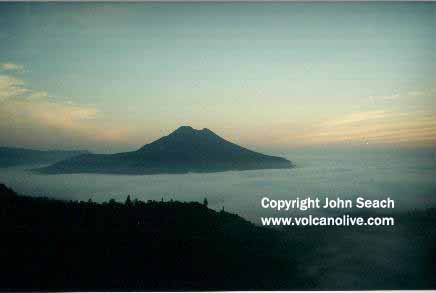
[ Bericht 15% gewijzigd door kahaarin op 11-11-2009 16:56:30 ]
be nice or go away
Mayon is een gevaarlijk vulkaantje idd
Bali dus ook... ook in beide gebieden aardbevingen... Filijpijnen kreeg een 5.5 vandaag
Bali dus ook... ook in beide gebieden aardbevingen... Filijpijnen kreeg een 5.5 vandaag
hee, die van Bali had ik al herschreven
Status Batur vulkaan op verhoogd naar 'waakzaam'
Status Batur vulkaan op verhoogd naar 'waakzaam'
quote:De Batur vulkaan, op het eiland Bali laat tekenen zien van verhoogde activiteit. De eerst vastgelegde historische uitbarsting was in 1804. Sindsdien is de vulkaan zeker 28 keer uitgebarsten met tussenperioden tussen de één en 39 jaar. Normaal barst de 1.717-meter hoge vulkaan uit op een strombolische manier, waarbij de lava simpelweg uit de krater stroomt. De laatste uitbarsting was op 7 juli 2000.
Hmm, deze doet ook al mee:quote:Op woensdag 11 november 2009 21:14 schreef Frutsel het volgende:
Mayon is een gevaarlijk vulkaantje idd
Bali dus ook... ook in beide gebieden aardbevingen... Filijpijnen kreeg een 5.5 vandaag
http://www.volcanodiscovery.com/en/volcano_news.htmlquote:Karangetang volcano (Siau Island, Sangihe Islands): small explosions
Navigation:
All news about: Karangetang volcano (Siau Island, Indonesia): news & eruption updates
Karangetang is active again, as the GVP/USGS editors report citing local newspaper sources. Batur might be getting active. According to news articles, a pyroclastic flow and a lahar occurred on 4 November. Residents saw active lava flows the next day. On 11 November, incandescent material was ejected
5 m into the air.

Het lijkt wel dat ze elkaar aansteken, mexican flu?
Chili ook al, met een oude bekende:
Dat is pas een gevaarlijke vulkaan!quote:Chaitén volcano (Chile), eruption update: growing lava dome
09h25 AM | Age: 3 hrs
Chaitén's lava dome continues its growth and can shed pyroclastic flows and produce ash eruptions at all times. The alert level remains at its highest (red).

[ Bericht 9% gewijzigd door kahaarin op 12-11-2009 12:17:56 ]
be nice or go away

Weet ik niet... Google-->Chaiten volcano-->images, geen idee of het gesoept is, vond het wel een mooi plaatje. Waarom dequote:
be nice or go away
Hoeft geen gesoepte foto te zijn trouwens.
Inorbit: zeg dat dan typluie triangeljosti
Beauregard: Een beetje FOK!ker laat het brood door z'n moeder smeren.
Ecosia
ek's 'n flash drive, jy's 'n floppy
Beauregard: Een beetje FOK!ker laat het brood door z'n moeder smeren.
Ecosia
ek's 'n flash drive, jy's 'n floppy
Ik ook, vandaar dat ik hem hier neerzet!quote:
Nee, dat denk ik ook niet, ik heb ooit eens een youtube filmpje gezien van de chaiten, kan hem zo niet meer vinden, dat zag er wel heftig uit.quote:Op donderdag 12 november 2009 13:41 schreef Jumparound het volgende:
Hoeft geen gesoepte foto te zijn trouwens.
Jullie subtitles zijn wel leuk onder elkaar, purr feed me en bedankt voor de vis.
* kahaarin gooit een stukje zalm in de groep*
Ah, gevonden! Lijkt me toch geen fotoshop:


be nice or go away
wtf, wowquote:
[..]
Hmm, deze doet ook al mee:
[..]
http://www.volcanodiscovery.com/en/volcano_news.html
[ afbeelding ]
Het lijkt wel dat ze elkaar aansteken, mexican flu?
Chili ook al, met een oude bekende:
[..]
Dat is pas een gevaarlijke vulkaan!
[ afbeelding ]
DeLuna vindt me dik ;(
Op zondag 22 juni 2014 12:30 schreef 3rdRock het volgende:
pas als jullie gaan trouwen. nu ben je gewoon die Oom Rubber die met onze mama leuke dingen doet :)
Op zondag 22 juni 2014 12:30 schreef 3rdRock het volgende:
pas als jullie gaan trouwen. nu ben je gewoon die Oom Rubber die met onze mama leuke dingen doet :)
Tnx for the fish!quote:Op donderdag 12 november 2009 13:51 schreef kahaarin het volgende:
[..]
Ik ook, vandaar dat ik hem hier neerzet!
[..]
Nee, dat denk ik ook niet, ik heb ooit eens een youtube filmpje gezien van de chaiten, kan hem zo niet meer vinden, dat zag er wel heftig uit.
Jullie subtitles zijn wel leuk onder elkaar, purr feed me en bedankt voor de vis.
* kahaarin gooit een stukje zalm in de groep*
Ah, gevonden! Lijkt me toch geen fotoshop:
Inorbit: zeg dat dan typluie triangeljosti
Beauregard: Een beetje FOK!ker laat het brood door z'n moeder smeren.
Ecosia
ek's 'n flash drive, jy's 'n floppy
Beauregard: Een beetje FOK!ker laat het brood door z'n moeder smeren.
Ecosia
ek's 'n flash drive, jy's 'n floppy
Jeutje, nog 1, wat is er aan de hand zeg?
Het was een poosje behoorlijk rustig maar het lijkt wel of dat stilte voor de storm was:
Deze is vorig jaar ook al uitgebarsten:
http://colombiareports.co(...)sands-evacuated.html
Hmm, Zuid Amerika en Indonesie lijken wakker geschud te worden.
Hopelijk gaan ze weer braaf slapen, al levert het mooie plaatjes op uitbarstingen zijn nooit grappig.....
Het was een poosje behoorlijk rustig maar het lijkt wel of dat stilte voor de storm was:
quote:Nevado del Huila volcano (Colombia), activity update: rapid lava dome growth
09h21 AM | Age: 5 hrs
The lava dome of Nevado del Huila continues to grow rapidly as INGEOMINAS reports. The volume of the new lava dome is estimated as nearly 25 million cubic meters. Small collapses occurred on the W part of the dome and gas
emissions were sometimes accompanied by pulsating ash emissions. Sulfur dioxide plumes rose 2.5 km above the lava dome and were seen in satellite imagery and the web camera drifting with the prevailing winds.
Deze is vorig jaar ook al uitgebarsten:
http://colombiareports.co(...)sands-evacuated.html

Hmm, Zuid Amerika en Indonesie lijken wakker geschud te worden.
Hopelijk gaan ze weer braaf slapen, al levert het mooie plaatjes op uitbarstingen zijn nooit grappig.....
be nice or go away

LEGAZPI CITY, Philippines – After spewing ash at least thrice last Wednesday, Mayon Volcano emitted a crater glow that grew more intense and was visible as far as 15 kilometers away the other night.
Ed Laguerta, resident volcanologist here of the Philippine Institute of Volcanology and Seismology (Phivolcs), said Mayon’s surface remains inflated despite the series of ash or phreatic explosions.
“This means that magmatic pressure inside the volcano is sustained. But all these activities are still within alert level 2,” Laguerta said in a radio interview.
He dismissed reports that Mayon is now gradually going back to normal due to fewer volcanic quakes detected after the ash explosions.
At least eight tremors were recorded in the past 24 hours, while the volcano’s sulfur dioxide emission was measured at 514 tons, way above the normal volume of 500 tons per day.
==================
Er broeit daar ietsquote:Mayon volcano, Philippines emitted 973 tons of sulphur dioxide yesterday, compared to 500 tons average
Lol, je was me net voor, de twitter van John Seach maar in de gaten houden denk ik, er broeit daar zeker iets:quote:Op woensdag 18 november 2009 12:16 schreef Frutsel het volgende:
[ afbeelding ]
LEGAZPI CITY, Philippines – After spewing ash at least thrice last Wednesday, Mayon Volcano emitted a crater glow that grew more intense and was visible as far as 15 kilometers away the other night.
Ed Laguerta, resident volcanologist here of the Philippine Institute of Volcanology and Seismology (Phivolcs), said Mayon’s surface remains inflated despite the series of ash or phreatic explosions.
“This means that magmatic pressure inside the volcano is sustained. But all these activities are still within alert level 2,” Laguerta said in a radio interview.
He dismissed reports that Mayon is now gradually going back to normal due to fewer volcanic quakes detected after the ash explosions.
At least eight tremors were recorded in the past 24 hours, while the volcano’s sulfur dioxide emission was measured at 514 tons, way above the normal volume of 500 tons per day.
==================
[..]
Er broeit daar iets
http://volcanolive.blogspot.com/quote:Twitter Updates - John Seach
Twitter Updates
Mayon volcano, Philippines emitted 973 tons of sulphur dioxide yesterday, compared to 500 tons average 18 minutes ago
Hopelijk zijn ze op tijd met evacueren, bijna de dubbele uitstoot lijkt me niet goed.
be nice or go away
Sorryquote:
[..]
Lol, je was me net voor, de twitter van John Seach maar in de gaten houden denk ik, er broeit daar zeker iets:
[..]
http://volcanolive.blogspot.com/
Hopelijk zijn ze op tijd met evacueren, bijna de dubbele uitstoot lijkt me niet goed.
Jij twittert dus ook?
Nee, ik twitter niet maar zijn tweets komen op zijn site, die heb ik wel gebookmarked.quote:Op woensdag 18 november 2009 12:32 schreef Frutsel het volgende:
[..]
Sorry
Jij twittert dus ook?
Wel grappig, soms dan hoor je een poos niets en dan ineens rommelt het overal, Chaiten is weer een beetje koest gelukkig, hopelijk valt het mee met Mayon.
be nice or go away
Als dat kreng maar binnenkort ophoudt met dit gedonder.
Mijn schoonzus moet binnenkort langs Mayon met de kinders...
Mijn schoonzus moet binnenkort langs Mayon met de kinders...
Ik ben een eckte rapnegert
Rood alarm voor dreigende vulkaanuitbarsting in Colombia
De Colombiaanse autoriteiten hebben het rood alarm afgekondigd wegens een mogelijke uitbarsting van de vulkaan Galeras, in het zuiden van het land, tegen de grens met Equador. Aan 8.000 mensen wordt gevraagd de omgeving onmiddellijk te verlaten.
De observatiepost vulkanologie in het departement Narino registreerde een explosie om 20h37 plaatselijke tijd en bracht de graad van alarm van oranje naar rood.
De hulporganisaties hebben meteen het bevel gegeven tot evacuatie in de zones nabij de vulkaan."Er zijn drie plaatsen die zich in het risicogebied bevinden: Pasto, Narino en Florida. Daar wonen samen ongeveer 8.000 mensen die onmiddellijk moeten vertrekken", klinkt het.
De vulkaan Galeras, gelegen in de Andes met zijn op 4.270 hoog, werd in 2004 opnieuw actief. (belga/jv)
hln
Hey FOK! is er weer!
Dit is een redelijk actieve vulkaan schijnt.
Galeras in 2006:
Van volcano blog:
Wiki:
Dit is een redelijk actieve vulkaan schijnt.
Galeras in 2006:

Van volcano blog:

Wiki:
quote:Galeras
GalerasLocation in Colombia
Elevation 4,276 metres (14,029 ft)[1]
Location Nariño, Colombia
Range Andes
Coordinates 01°13′00″N 77°22′00″W / 1.2166667°N 77.3666667°W / 1.2166667; -77.3666667Coordinates: 01°13′00″N 77°22′00″W / 1.2166667°N 77.3666667°W / 1.2166667; -77.3666667[1]
Type Complex volcano
Volcanic arc/belt North Volcanic Zone
Last eruption September 30, 2009
Galeras (Urcunina among the 16th-century indigenous people) is an Andean stratovolcano in the Colombian department of Nariño, near the departmental capital Pasto. Its summit rises 4,276 metres (14,029 ft) above sea level. It has erupted frequently since the Spanish conquest, with its first historical eruption being recorded on December 7, 1580.[2] A 1993 eruption killed nine people, including six scientists who had descended into the volcano's crater to sample gases.[3] It is currently the most active volcano in Colombia.
be nice or go away
quote:Evacuations near Galeras volcano
Following a strong eruption of the southern Colombian Galeras volcano on Friday, more than a thousand people responded to authorities' calls to evacuate the region.
The volcano, that has caused several alerts over the past year, erupted again on Friday, forcing local authoritis to declare a red alert and call on the thousands of inhabitants of the region to evacuate.
Locals are asked to put on masks to avoid inhaling ash coming from the volcano.
Geologists monitoring the volcano's activity declared a code orange a few weeks ago and have been expecting the volcano to erupt. Until now, the majority of the locals refused to leave their homes.

Lol, hmm, die nemen de frase; 'Eerst Napels zien en dan sterven' wel erg letterlijk...quote:Op maandag 23 november 2009 13:54 schreef Frutsel het volgende:
Gevaarlijke vulkaan bij Napels komt tot leven? Let's drill!
be nice or go away
http://volcanolive.blogsp(...)new-guinea-john.html
quote:Wednesday, November 25, 2009
Karkar Volcano, Papua New Guinea - John Seach
Posted by John Seach
An eruption occurred at Karkar volcano at 6:39 pm on 25th November 2009. The eruption plume reached a height of 45,000 ft. A magnitude 5.1 earthquake hit 90 km SSE of Karkar volcano 7.5 hours before the eruption.

be nice or go away
Lijkt wel of er 'overal' een increase qua aktiviteit isquote:Gaua Volcano, Vanuatu
An increase in activity at Gaua volcano, Vanuatu has forced the evacuation of over 300 people from three villages on the west coast of Gaua Island. People have been suffering from respiratory problems in the last few days as a strong wind has carried the gas and ash over villages. Two boats from the police and health department in Torba are starting to evacuate people this morning. Negotiations are taking place with ships owners to help with the evacuation because the two motor boats cannot carry enough people. Chiefs from two villages, Namasari and Lembot, from the east of Gaua met yesterday about housing the relocated people. The National Disaster Management Office has maintained the level of alert on 2 (out of a maximum 4) but during the past days, a fall and gas emission has increased.
ik denk dat je dat pas kan zeggen als er nóg meer vulkanen actief worden. 3 of 4 is toch niet zo spannend?
Inorbit: zeg dat dan typluie triangeljosti
Beauregard: Een beetje FOK!ker laat het brood door z'n moeder smeren.
Ecosia
ek's 'n flash drive, jy's 'n floppy
Beauregard: Een beetje FOK!ker laat het brood door z'n moeder smeren.
Ecosia
ek's 'n flash drive, jy's 'n floppy
Mjah, das wel zo maar ik kijk alleen naar dit topic...en hoe dat ook ineens aktief wordt...quote:
ik denk dat je dat pas kan zeggen als er nóg meer vulkanen actief worden. 3 of 4 is toch niet zo spannend?
Midden september een melding van aktiviteit bij de Mayon, twee weken later de Chaiten en weer twee weken later Montserrat.
En nu in zeer korte tijd zien (en horen) we ineens (hernieuwde) aktiviteit bij de Mayon en Chaiten en daarnaast ineens ook bij Vanuatu, Karkar, Napels, Galeras, Nevado de Huilo, Karekatang en Batur.
En dat allemaal gemeld binnen een dag of tien... Letten wij dan meer op? Is er dan meer nieuws of is er simpelweg meer vulkanische aktiviteit?
Ik vind het prachtig hoor, hoe meer aktieve mensen in dit topic (en op DE) des te beter
Zijn daar geen goede statistieken over te vinden? Lijkt me wel interessant
DeLuna vindt me dik ;(
Op zondag 22 juni 2014 12:30 schreef 3rdRock het volgende:
pas als jullie gaan trouwen. nu ben je gewoon die Oom Rubber die met onze mama leuke dingen doet :)
Op zondag 22 juni 2014 12:30 schreef 3rdRock het volgende:
pas als jullie gaan trouwen. nu ben je gewoon die Oom Rubber die met onze mama leuke dingen doet :)
Naples kan je van zeggen dat het al 40 jaar aan de gang is Maar verder heb je gelijk
Ik zal ook mn steentje bijdragen
Ik zal ook mn steentje bijdragen
Inorbit: zeg dat dan typluie triangeljosti
Beauregard: Een beetje FOK!ker laat het brood door z'n moeder smeren.
Ecosia
ek's 'n flash drive, jy's 'n floppy
Beauregard: Een beetje FOK!ker laat het brood door z'n moeder smeren.
Ecosia
ek's 'n flash drive, jy's 'n floppy
Misschien is het louter de media hoor... je hoort immers ook steeds meer nieuws over meteoren die gespot worden.
We naderen 2012...
We naderen 2012...
het is de mediaquote:Op donderdag 26 november 2009 13:28 schreef Frutsel het volgende:
Misschien is het louter de media hoor... je hoort immers ook steeds meer nieuws over meteoren die gespot worden.
We naderen 2012...
ik zie hier niet meer of minder aarbevingen dan voorheen
http://earthquake.usgs.gov/
En als de waarnemingen verbeteren lijkt het ook alsof er steeds meer meldigen zijn
Maar de tijd zal het leren!
Inorbit: zeg dat dan typluie triangeljosti
Beauregard: Een beetje FOK!ker laat het brood door z'n moeder smeren.
Ecosia
ek's 'n flash drive, jy's 'n floppy
Beauregard: Een beetje FOK!ker laat het brood door z'n moeder smeren.
Ecosia
ek's 'n flash drive, jy's 'n floppy
het zijn idd de mediaquote:Op donderdag 26 november 2009 13:38 schreef Jumparound het volgende:
[..]
het is de media
ik zie hier niet meer of minder aarbevingen dan voorheen
http://earthquake.usgs.gov/
En als de waarnemingen verbeteren lijkt het ook alsof er steeds meer meldigen zijn
Maar de tijd zal het leren!
Je hebt tegenwoordig zo makkelijk info uit alle hoeken van de wereld tot je beschikking dat er gewoon meer over bericht wordt.
Wel erg leuk/interessant overigens
[b]Op maandag 6 september 2010 00:28 schreef tong80 het volgende:[/b]
GVD Wat moet jij een trotse vader zijn :)
:P
GVD Wat moet jij een trotse vader zijn :)
:P
Grappigquote:
[..]
het is de media
ik zie hier niet meer of minder aarbevingen dan voorheen
http://earthquake.usgs.gov/
En als de waarnemingen verbeteren lijkt het ook alsof er steeds meer meldigen zijn
Maar de tijd zal het leren!
In het Centrale Aardbevingstopic, had ik net dinsdag gemeld dat ik het gevoel had dat er meer aardbevingen waren (in Californie dan)
Aardbevingen #8:
Media is zeker een ding, maar misschien dat hier nu ook meer mensen komen die het interessant vinden en nieuws posten
Het valt zo moeilijk te meten of er nu meer vulkaanuitbarstingen of aardbevingen zijn dan 'vroeger'. We hebben nu gewoonweg veel meer meetpunten.quote:Op donderdag 26 november 2009 13:43 schreef Frutsel het volgende:
[..]
Grappig
In het Centrale Aardbevingstopic, had ik net dinsdag gemeld dat ik het gevoel had dat er meer aardbevingen waren (in Californie dan)
Aardbevingen #8:
Media is zeker een ding, maar misschien dat hier nu ook meer mensen komen die het interessant vinden en nieuws posten
Maar als er straks bij Napoli een grote vulkaan knalt, dan loopt dit topic wel storm denk ik
[b]Op maandag 6 september 2010 00:28 schreef tong80 het volgende:[/b]
GVD Wat moet jij een trotse vader zijn :)
:P
GVD Wat moet jij een trotse vader zijn :)
:P
Stel je eens voor dat de Zuidwal vulkaan door een extreme aardbeving weer tot leven komt....quote:Op donderdag 26 november 2009 13:46 schreef Againzender het volgende:
[..]
Het valt zo moeilijk te meten of er nu meer vulkaanuitbarstingen of aardbevingen zijn dan 'vroeger'. We hebben nu gewoonweg veel meer meetpunten.
Maar als er straks bij Napoli een grote vulkaan knalt, dan loopt dit topic wel storm denk ik
Dat is pas iets voor een storm topic
<a href="http://www.vwkweb.nl/" rel="nofollow" target="_blank">[b]Vereniging voor weerkunde en klimatologie[/b]</a>
<a href="http://www.estofex.org/" rel="nofollow" target="_blank">[b]ESTOFEX[/b]</a>
<a href="http://www.estofex.org/" rel="nofollow" target="_blank">[b]ESTOFEX[/b]</a>
| Forum Opties | |
|---|---|
| Forumhop: | |
| Hop naar: | |