WKN Weer, Klimaat en Natuurrampen
Lees alles over het onstuimige weer op onze planeet, volg orkanen en tornado's, zie hoe vulkanen uitbarsten en hoe Moeder Aarde beeft bij een aardbeving. Alles over de verwoestende kracht van onze planeet en tal van andere natuurverschijnselen.


Flinke BIEM in Ethiopië:
https://en.wikipedia.org/wiki/Hayli_Gubbi
Filmpjes:
(helaas is tweets embedden in Fok nog maar amper te doen)
[ Bericht 18% gewijzigd door Frutsel op 25-11-2025 08:24:20 ]
https://en.wikipedia.org/wiki/Hayli_Gubbi
Filmpjes:
(helaas is tweets embedden in Fok nog maar amper te doen)
[ Bericht 18% gewijzigd door Frutsel op 25-11-2025 08:24:20 ]
ph'nglui mglw'nafh Cthulhu R'lyeh wgah'nagl fhtagn

Mooiquote:Op maandag 24 november 2025 11:49 schreef xpompompomx het volgende:
Flinke BIEM in Ethiopië:
[ afbeelding ]
https://en.wikipedia.org/wiki/Hayli_Gubbi
Filmpjes:
[ x ]
[ x ]
[ x ]
De laatste tijd valt me op dat als je de X veranderd in het woord Twitter dat hij het dan wel doet.quote:(helaas is tweets embedden in Fok nog maar amper te doen)
Dus ipv x.com twitter.com gebruiken
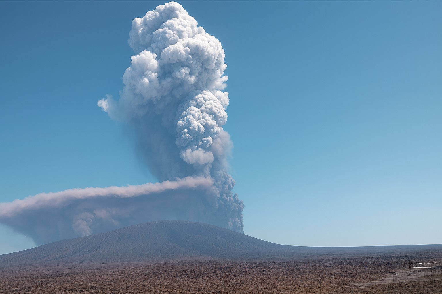
De opsplitsing van Afrika is weer een stukje dichterbijquote:Vulkaan in Ethiopië barst voor het eerst in duizenden jaren uit
In Ethiopië is een vulkaan uitgebarsten die voor zover bekend duizenden jaren inactief was. Het gaat om de Hayli Gubbi, in het noorden van het land. De vulkaan ligt in een gebied met meerdere actieve vulkanen, maar was zelf dus lange tijd slapend.
De uitbarsting begon gisteren. Op beelden is een kilometershoge aswolk te zien.
Het gebied rond de vulkaan is zeer dunbevolkt. Lokale autoriteiten en Ethiopische media maken geen melding van schade of slachtoffers. De uitbarsting is inmiddels gestopt.
Het Toulouse Volcanic Ash Advisory Center, dat na uitbarstingen wereldwijd aswolken monitort, zegt dat asdeeltjes tussen 7 en 13 kilometer de lucht in zijn geslingerd. De aswolk trekt over Jemen en Oman de Indische Oceaan op. Het Franse instituut verwacht dat de wolk morgen de Himalaya bereikt.
De Hayli Gubbi ligt in de buurt van de Erta Ale. Die vulkaan is geregeld actief en trekt daardoor ook toeristen naar het gebied in Noord-Ethiopië. Dat ligt op de zogeheten Grote Slenk, waar twee tektonische platen uit elkaar bewegen.
quote:Hayli Gubbi volcano erupts for the first time in recorded history, Ethiopia
Hayli Gubbi volcano in Ethiopia erupted for the first time in at least 12 000 years on November 23, 2025, marking its first confirmed Holocene activity. The eruption generated a plume rising to about 14 km (46 000 feet) above sea level before drifting toward the Arabian Peninsula. Updated satellite data from IASI-C on November 24 detected a large SO2 plume between 5 km (16 400 feet) and 17 km (55 800 feet), with a center-of-mass height near 16 km (52 500 feet) and a total mass loading of 58.4 kt.
Hayli Gubbi volcano in Ethiopia’s Afar Rift Volcanic Province erupted at about 08:30 UTC on November 23, 2025. This is the first confirmed Holocene eruption of the volcano and the first documented eruptive activity in the instrumental record.
The Toulouse Volcanic Ash Advisory Center (VAAC) issued multiple advisories throughout the day as ash and gas spread across the region, initially rising to roughly 3 km (10 000 feet) above sea level and later reaching approximately 14 km (46 000 feet) during the strongest phase of the eruption.
By 20:00 UTC on November 23, VAAC Toulouse confirmed that the eruption had stopped, but residual ash up to around 5.2–6.1 km (17 000–20 000 feet) above sea level continued to drift over Ethiopia.
Updated advisories issued early on November 24 reported that the upper-level plume, containing both ash and SO2, had moved east and northeast across the Red Sea and was located over Yemen and Oman at altitudes of up to about 14 km (46 000 feet).
At present, no confirmed reports of casualties or major damage in nearby settlements have been reported, but the remote setting and wide-area ash/gas dispersal raise potential concerns for communities, livestock and infrastructure.
Forecast dispersion data suggest continued transport of ash and gas toward the Arabian Peninsula and the western Indian Ocean. Wind shear produced a split plume structure, with lower-level ash drifting southeast at roughly 9 km/h (6 mph) and upper-level material moving east-northeast.
Updated SO2 measurements from the Support to Aviation Control Service (SACS) using IASI-C at 06:31 UTC on November 24 showed that a large and elevated SO2 plume remained in the atmosphere after the end of eruptive activity.
The retrieval reported maximum SO2 values of 15.1 DU near 14.39° N, 45.08° E, with plume heights between 5 km (16 400 feet) and 17 km (55 800 feet). The center-of-mass height was detected near 16 km (52 500 feet), suggesting that most of the remaining SO2 is concentrated at upper-tropospheric to lower-stratospheric levels.
Total SO2 mass loading reached 58.405 kt, and the plume area expanded to approximately 842 145 km2 (325 100 mi2), drifting eastward toward the Arabian Peninsula and the western Indian Ocean.
According to the Smithsonian Institution’s Global Volcanism Program (GVP), Hayli Gubbi has no known eruptions during the Holocene. The volcano is located in the southernmost edifice of the Erta Ale Range.
Recent tectonism has formed a summit graben occupied by a symmetrical scoria cone with a 200 m (650 feet) wide crater displaying fumarolic activity. An older shield volcano is overlain by recent fissure-fed lava flows to the north.
Lava flows from the southern axial fissure system have reached the floor of the Giulietti Plain, covering sedimentary deposits dated to about 8 200 years. Open fissures extend for more than 10 km (6.2 miles) and contain numerous small spatter cones and pit craters.
Large Volcanic Eruptions of Fuego Volcano Caught on Camera
Bekijk deze YouTube-video
https://x.com/ChynoNews/status/2006482474633998731?s=20
https://volcano.si.edu/volcano.cfm?vn=342090
https://www.volcanodiscov(...)/vaac-advisory-2026-
https://www.volcanodiscov(...)visory-2026-003.html
Bekijk deze YouTube-video
https://x.com/ChynoNews/status/2006482474633998731?s=20
https://volcano.si.edu/volcano.cfm?vn=342090
https://www.volcanodiscov(...)/vaac-advisory-2026-
https://www.volcanodiscov(...)visory-2026-003.html
My age is very
Inappropriate
for my behavior
Inappropriate
for my behavior
Bekijk deze YouTube-videoquote:Evacuations underway after Mayon volcano’s dome collapse and pyroclastic flows, Philippines
Nearly 3 000 residents have been evacuated from communities around Mayon volcano in Albay Province, Philippines, after the Philippine Institute of Volcanology and Seismology (PHIVOLCS) raised the alert status to Level 3 on January 6, 2026. The evacuation follows intensified dome collapse events, pyroclastic density currents, and ongoing effusive lava extrusion at the summit.
Authorities in Albay Province ordered the evacuation of 2 800 residents from 729 households within the 6 km (3.7 miles) Permanent Danger Zone (PDZ) surrounding Mayon volcano after PHIVOLCS raised the alert status to Level 3 at 13:20 LT (05:20 UTC) on January 6.
Another 600 residents living just outside the PDZ voluntarily moved to government shelters, according to the Office of Civil Defense (OCD) regional office.
The decision to elevate the alert level followed intensified volcanic activity marked by partial dome collapse, generation of pyroclastic density currents (PDCs) extending up to 2 km (1.2 miles) from the crater, and continuous slow lava extrusion. PHIVOLCS recorded 346 rockfall events and four volcanic earthquakes between January 1 and 6, accompanied by nighttime incandescence visible from nearby communities.
Ground deformation data from continuous GPS, electronic tilt, and EDM measurements indicate ongoing inflation along the eastern and southeastern slopes, confirming the slow ascent of shallow magma. PHIVOLCS described the activity as an effusive magmatic eruption — a quiet but sustained release of lava building the summit dome.
https://www.volcanodiscov(...)ode-in-progress.html
Bekijk deze YouTube-video
Bekijk deze YouTube-video
[ Bericht 19% gewijzigd door Puzzie op 16-02-2026 08:29:56 ]
Bekijk deze YouTube-video
Bekijk deze YouTube-video
[ Bericht 19% gewijzigd door Puzzie op 16-02-2026 08:29:56 ]
My age is very
Inappropriate
for my behavior
Inappropriate
for my behavior

quote:Kīlauea eruption sends ash plume to 9 km (30 000 feet), disrupts flights near Hilo, Hawaii
Episode 43 of the ongoing eruption at Kīlauea began at about 09:17 LT on March 10, 2026, producing lava fountains exceeding 400 m (1 300 feet) from vents inside Halemaʻumaʻu crater, according to the USGS Hawaiian Volcano Observatory (HVO). Tephra fallout forced the closure of part of Highway 11 and disrupted flights at Hilo International Airport as an ash plume rose to about 9 km (30 000 feet) above sea level.
pisode 43 of the ongoing summit eruption at Kīlauea began at approximately 09:17 LT (19:17 UTC) on March 10, according to the United States Geological Survey Hawaiian Volcano Observatory (HVO). The eruption is occurring within Halemaʻumaʻu crater at the summit of the volcano.
Lava fountains quickly intensified after the eruption began. According to HVO, fountains from the south vent reached about 350 m (1 150 feet), while fountains from the north vent reached about 300 m (1 000 feet). Maximum fountain heights during the episode exceeded 400 m (1 300 feet), with later observations showing the south vent reaching approximately 399 m (1 310 feet) and the north vent slightly under 300 m (985 feet).
The eruption produced significant tephra fallout downwind of the summit. Fragments up to 7.6 cm (3 inches) in diameter were reported in Volcano Village and Mauna Loa Estates, while Royal Hawaiian Estates reported fragments up to 1.3 cm (0.5 inches) along with strands of Pele’s hair. Continuous fallout covering the ground was reported at overlooks within Hawaiʻi Volcanoes National Park and near Volcano Golf Course.
|
|