WKN Weer, Klimaat en Natuurrampen
Lees alles over het onstuimige weer op onze planeet, volg orkanen en tornado's, zie hoe vulkanen uitbarsten en hoe Moeder Aarde beeft bij een aardbeving. Alles over de verwoestende kracht van onze planeet en tal van andere natuurverschijnselen.


Als er maar genoeg as valt zullen er verder van de vulkaan ook flink wat huizen instorten, een laag as heeft een flink gewicht en daarop zijn huizen niet berekend.quote:Op donderdag 8 november 2007 11:31 schreef kahaarin het volgende:
[..]
25 km, dat is toch wel redelijk uit de directe gevaren zone?
As en overstroming misschien daargelaten?
De mensen die direct op de flank van een vulkaan wonen zijn toch heel wat kwetsbaarde toch?
Pinatubo lag rond de 20 km van clark airbase , hier zijn ook nog verschillende gebouwen ingestort vanwegen de as regens.
http://nl.wikipedia.org/wiki/Mount_Pinatubo
ja, die is 5 kilometer voor deze vulkaan. As kan uiteraard wel, en overstromingen ook, al gaan die meestal richting het westen en oosten. Geen garanties, ook hier nietquote:Op donderdag 8 november 2007 11:31 schreef kahaarin het volgende:
[..]
25 km, dat is toch wel redelijk uit de directe gevaren zone?
As en overstroming misschien daargelaten?
De mensen die direct op de flank van een vulkaan wonen zijn toch heel wat kwetsbaarde toch?
quote:Op donderdag 8 november 2007 12:04 schreef Basp1 het volgende:
[..]
Als er maar genoeg as valt zullen er verder van de vulkaan ook flink wat huizen instorten, een laag as heeft een flink gewicht en daarop zijn huizen niet berekend.
Pinatubo lag rond de 20 km van clark airbase , hier zijn ook nog verschillende gebouwen ingestort vanwegen de as regens.
http://nl.wikipedia.org/wiki/Mount_Pinatubo
Nog verder weg zelfs!quote:De Verenigde Staten hadden twee grote luchtmachtbasissen in deze regio ten tijde van de uitbarsting; Subic Bay Naval Base lag 75 kilometer ten zuidwesten van de vulkaan, terwijl Clark Air Base op een kleine 40 kilometer ten oosten van de vulkaan lag. Beide basissen werden verlaten nadat ze ernstig beschadigd werden tijdens de uitbarsting.
Gevonden onder het kopje nasleep, het betreft hier wel schade door natte as en er was ook sprake van noodweer, ik weet niet wat er was gebeurd als het was gebeurd bij gewoon weer, bij directe gevaren zone bedoel ik eigenlijk bedreiging door lava, brandend gas en lahars.
Hij zal niet direct in levensgevaar zijn als de vulkaan uitbarst en hoogstwaarschijnlijk ook niet in huis blijven zitten als er zo'n uitbarsting is geweest, denk ik.
Hij wilde ook al foto's gaan maken van Mount Kelud, een uitbarsting in de achtertuin zal hij dan ook niet aan zijn neus voorbij laten gaan.
be nice or go away
In geval van uitbarsting ben je toch ook helemaal niet in huis?quote:Op donderdag 8 november 2007 12:09 schreef indahnesia.com het volgende:
[..]
ja, die is 5 kilometer voor deze vulkaan. As kan uiteraard wel, en overstromingen ook, al gaan die meestal richting het westen en oosten. Geen garanties, ook hier niet
Dan ga je toch foto's maken?
be nice or go away
ook dat nog eens inderdaad, tenzij ik lig te pitten en dat ding ineens explosief wordt.. tja...quote:Op donderdag 8 november 2007 12:16 schreef kahaarin het volgende:
[..]
In geval van uitbarsting ben je toch ook helemaal niet in huis?
Dan ga je toch foto's maken? [afbeelding]
Anak Krakatau erupts
Anak Krakatau, built on the same lava plume as the Krakatoa volcano that killed tens of thousands in 1883, continued to spew lava, hot gas and rocks Thursday into the Sunda Strait between the Indonesian islands of Java and Sumatra.
Anak Krakatua, or "Child of Krakatoa" in the official Indonesian language, rose from the water in 1930 at the same spot where Krakatoa had blown itself apart.
Elsewhere in Indonesia, the government lowered the alert status of the Kelud volcano, meaning that thousands of people who fled its slopes for government shelters can return home.
Mount Kelud on the densely populated island of Java had been on top alert for several weeks.
"The volcano no longer has the energy needed for an explosive eruption that would threaten the lives of people living nearby," Surono, the chief volcanologist at the government's volcano agency, said on the decision to downgrade Kelud's status.
Like many Javanese, Surono uses a single name.
In 1990, Kelud spewed searing fumes and lava that killed more than 30 people and injured hundreds. In 1919, a powerful explosion that reportedly could be heard hundreds of miles away killed at least 5,160.
Thousands of people from villages close to Kelud's crater lake had earlier heeded evacuation orders and moved to tent camps or government buildings, though many ignored the warnings and remained in the danger zone.
The government volcano agency said Kelud remained on the second-highest alert level and told villagers to remain vigilant because the mountain was very unpredictable. It said that villagers could return home, but should not venture close to the crater, which was still emitting smoke.
Indonesia is prone to volcanic eruptions and earthquakes because of its location on the so-called "Ring of Fire" — a series of fault lines stretching from the Western Hemisphere through Japan and Southeast Asia.


Wel frappant.. iedereen op z'n hoede voor Kelud en die lijkt net weer veilig en prompt gaat de Krakatau 
Ik heb helemaal niets gezien als 'aankondiging' voor de Krakatau, kwam dit nou zo onverwachts?
Ik heb helemaal niets gezien als 'aankondiging' voor de Krakatau, kwam dit nou zo onverwachts?
I can only please one person per day. Today is not your day. Tomorrow isn't looking too good either.
Het was wel bekend dat hij actief was, maar dat heeft volgensmij het grote nieuws niet echt gehaald. Denk dat de Kelud het nieuws wat dat betreft een beetje te veel heeft overheerst.quote:Op donderdag 8 november 2007 19:54 schreef E.T. het volgende:
Wel frappant.. iedereen op z'n hoede voor Kelud en die lijkt net weer veilig en prompt gaat de Krakatau
Ik heb helemaal niets gezien als 'aankondiging' voor de Krakatau, kwam dit nou zo onverwachts?
De Krakatau is altijd redelijk actief. Enkele dagen geleden kwam er ineens een neuwe krater te voorschijn, en toen issie actiever geworden.
`Was dit niet die vulkaan waarvan ze een docu hadden gemaakt. Dat als deze zou uitbarsten dat er een deel kon afbreken en in de zee kon zakken waardoor er een enorme vloedgolf zou ontstaan?
Nothing is worth doing unless the consequences may be serious!
Iets anders, niets alarmerends maar misschien wel interressant voor de geinteresseerden...
Op de science sectie van news.yahoo.com staat een berichtje van Asociated Press met de titel
Ground said rising at Yellowstone Park
Mijn gedachte: Er zijn hier vast wel mensen die dat soort berichten volgen, dus maar even tippen.
Op de science sectie van news.yahoo.com staat een berichtje van Asociated Press met de titel
Ground said rising at Yellowstone Park
Mijn gedachte: Er zijn hier vast wel mensen die dat soort berichten volgen, dus maar even tippen.
Huidige trend atmosf. CO2 Mauna Loa: 411 ppm ,10 jaar geleden: 387 ppm , 25 jaar geleden: 358 ppm
Yep, maar vers van de pers is vers van de persquote:Op vrijdag 9 november 2007 01:51 schreef indahnesia.com het volgende:
Dat van die Gele Steen is volgens mij altijd al aan de gang? Het is immers een vulkaan idd.
Huidige trend atmosf. CO2 Mauna Loa: 411 ppm ,10 jaar geleden: 387 ppm , 25 jaar geleden: 358 ppm
moah, ik kom van de Kelud inmiddels ook berichten tegen die 4 keer zijn herhaald sinds 16 oktober  Steeds hetzelfde verhaaltje van gedwongen evacuatie. Maar inmidddels mag men weer terug.
Ook de ijen-vulkaan (oostelijk Java) is actief geworden:
http://www.metrotvnews.com/berita.asp?id=48731
Bericht wordt nog vertaald op dit moment
http://www.metrotvnews.com/berita.asp?id=48731
Bericht wordt nog vertaald op dit moment
Hoogstws betekent het niets (bijzonders). Zoals Indahnesia al zei, Yellow is constant in beweging. De meting is pas zo'n 80 jaar aan de gang. in de 600.000 jaar oude huidige Yellowstone zal dit waarschijnlijk niet meer zijn dan een 'boertje'. Echter, een kleine eruptie is ook niet uitgesloten. Als je over een hele lange periode zou kijken, zou Yellowstone op en neer gaan als een soort van hartritme. Hoogstws niets waar je je druk over hoeft te maken dus.quote:Op vrijdag 9 november 2007 01:41 schreef barthol het volgende:
Iets anders, niets alarmerends maar misschien wel interressant voor de geinteresseerden...
Op de science sectie van news.yahoo.com staat een berichtje van Asociated Press met de titel
Ground said rising at Yellowstone Park
Mijn gedachte: Er zijn hier vast wel mensen die dat soort berichten volgen, dus maar even tippen.
In mijn schooltijd (goede oude tijd ) waren er ook al regelmatig van zulke berichten over Yellowstone.
Ik weet nog dat we het er over gehad hebben bij Aardrijkskunde destijds En dat is uchtuch-jaar geleden
Ik weet nog dat we het er over gehad hebben bij Aardrijkskunde destijds
I can only please one person per day. Today is not your day. Tomorrow isn't looking too good either.
Nee, dat zou een van de canarsiche eilanden zijn.quote:Op vrijdag 9 november 2007 00:55 schreef PhoeniXProjects het volgende:
`Was dit niet die vulkaan waarvan ze een docu hadden gemaakt. Dat als deze zou uitbarsten dat er een deel kon afbreken en in de zee kon zakken waardoor er een enorme vloedgolf zou ontstaan?
http://www.dossierx.nl/content/view/214/61/
Klopt en ook daar loopt een heel topic overquote:Op vrijdag 9 november 2007 12:45 schreef Basp1 het volgende:
[..]
Nee, dat zou een van de canarsiche eilanden zijn.
http://www.dossierx.nl/content/view/214/61/
Mega tsunami door in zee vallen van eiland La Palma?
Owh, nog een boeiend topicquote:Op vrijdag 9 november 2007 12:52 schreef Frutsel het volgende:
[..]
Klopt en ook daar loopt een heel topic over [afbeelding]
Mega tsunami door in zee vallen van eiland La Palma?
Vulkanen! 
"It's hard to argue against cynics - they always sound smarter than optimists because they have so much evidence on their side."
vast wel een keer, maar het is niet meer zo direct als eerst gevreesd/gedacht.quote:Op zondag 11 november 2007 14:36 schreef Bakakame het volgende:
Hoe zit het nu met Kelud? Gebeurt niks meer mee (denken ze)?
Klopt, ook daar loopt een topic overquote:Op vrijdag 9 november 2007 01:41 schreef barthol het volgende:
Iets anders, niets alarmerends maar misschien wel interressant voor de geinteresseerden...
Op de science sectie van news.yahoo.com staat een berichtje van Asociated Press met de titel
Ground said rising at Yellowstone Park
Mijn gedachte: Er zijn hier vast wel mensen die dat soort berichten volgen, dus maar even tippen.
interessant om te lezen
Mijn usericon is mede mogelijk gemaakt door wonderer.
Live from Sparta MO
JOE-ES-EE!!
Live from Sparta MO
JOE-ES-EE!!
daar ook maar even een tvp-tje geplaatst.
Hier is het weer zoals voorheen. Rommelende vulkanen en daar blijft het bij.
Hier is het weer zoals voorheen. Rommelende vulkanen en daar blijft het bij.
*Eindelijk weer verbinding heeft*quote:Op dinsdag 13 november 2007 08:29 schreef indahnesia.com het volgende:
daar ook maar even een tvp-tje geplaatst.
Hier is het weer zoals voorheen. Rommelende vulkanen en daar blijft het bij.
Die stomme bergen sussen iedereen in slaap en gaan dan als ze weer tot de orde van de dag zijn overgegaan dan gaan ze rellen.
be nice or go away
Die aardbevingen bij Raba en Labuhanbajo zijn allemaal net ten oosten van de Tambora vulkaan. Nu is deze vrijwel niet actief, maar zit er wat aan te komen?
Date Magn. Location Long. Lat.
2007-11-26 10:31:58 WITA 5.6 41km N.W. of Raba 118.700 -8.100
2007-11-26 09:56:55 WITA 5.1 62 km S.W. of Labuhanbajo 119.350 -8.670
2007-11-26 05:44:59 WITA 5.0 93 km N.W. of Raba 118.740 -7.630
2007-11-25 19:53:10 UTC 6.8 48 kmN.W. of Raba 118.520 -8.110
2007-11-25 17:41:37 UTC 6.0 107 km N.W. of Mukomuko 100.180 -2.360
2007-11-25 17:15:10 UTC 5.0 44 km N.W. of Raba 118.480 -8.180
2007-11-25 16:52:50 UTC 4.9 66 km S. of Raba 118.550 -9.030
2007-11-26 00:02:20 WITA 6.7 50 km N.W. of Raba 118.350 -8.270
2007-11-25 17:07:55 WIB 5.6 164 km S.W. of Bengkulu 101.870 -5.220
http://indahnesia.com/earthquake/2/last_24_hours.php
Dit las ik op de site van Jan Visser
quote:mogelijk een vulkaanuitbarsting op IJsland
Sinds afgelopen vrijdag zijn honderden kleine aardbevingen geregistreerd in de IJslandse regio Upptyppingar. Dat gebied is gesitueerd ten oosten van de beroemde vulkaan Askja en ten noorden van Europa's grootste gletsjer de Vatnajökull. De meeste bevingen zijn waargenomen op een diepte van 13-15 kilometer maar wanneer ze dichter aan het aardoppervlak komen, is er kans op een vulkaanuitbarsting. Dit zegt Sigthrudur van de Icelandic Meteorological Office.
Het gebied ten noorden van de Vatnajökull gletsjer is vulkanisch actief maar de laatste keer dat daar een eruptie heeft plaatsgevonden is 1000 jaar geleden. De Askja kwam voor het laatst tot uitbarsting in 1961.
Hier is alles vrijwel rustig.Dat heeft me mooi de gelegenheid om lekker op vakantie te gaan volgende week.
Je roept het wel een beetje af zo, Kelud is toch van de onverwachte uitbarstingen?quote:Op donderdag 20 december 2007 12:43 schreef indahnesia.com het volgende:
Hier is alles vrijwel rustig.Dat heeft me mooi de gelegenheid om lekker op vakantie te gaan volgende week.
Edit: En prettige vakantie natuurlijk!
be nice or go away
Als ik op Bali ben ga ik NIET terug voor een uitbarsting. Forget it.. die villa met zwembad laat ik niet schietenquote:Op donderdag 20 december 2007 13:17 schreef kahaarin het volgende:
[..]
Je roept het wel een beetje af zo, Kelud is toch van de onverwachte uitbarstingen? [afbeelding]
Edit: En prettige vakantie natuurlijk! [afbeelding]
Dat had ik begrepen, daarom ook prettige vankantie natuurlijk!quote:Op donderdag 20 december 2007 13:30 schreef indahnesia.com het volgende:
[..]
Als ik op Bali ben ga ik NIET terug voor een uitbarsting. Forget it.. die villa met zwembad laat ik niet schieten
Villa met zwembad, klinkt goed, lekker ontspannen en bijtanken!
be nice or go away
Ja, inderdaad... dat zou de eerste ontspannen week zijn in een jaar tijd eigenlijk.. maar goed, alles is relatief natuurlijk. Internet gaat wel mee bijvoorbeeld, dus daar gaat het eigenlijk al fout.quote:Op donderdag 20 december 2007 13:50 schreef kahaarin het volgende:
[..]
Dat had ik begrepen, daarom ook prettige vankantie natuurlijk! [afbeelding]
Villa met zwembad, klinkt goed, lekker ontspannen en bijtanken! [afbeelding]
Natuurlijk niet, naast het zwembad, op een ligstoel, ice-tea erbij en i-netten afwisselen met af en toe een frisse duik, lijkt me heerlijk!quote:Op donderdag 20 december 2007 14:00 schreef indahnesia.com het volgende:
[..]
Ja, inderdaad... dat zou de eerste ontspannen week zijn in een jaar tijd eigenlijk.. maar goed, alles is relatief natuurlijk. Internet gaat wel mee bijvoorbeeld, dus daar gaat het eigenlijk al fout.
be nice or go away

supervolcano avond op discovery
"We meet every day at the same cafe, six-thirty and no one knows she'll be there."

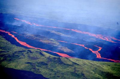
SANTIAGO, Chile — A volcano in southern Chile erupted on Tuesday, spewing lava and ash, and forcing the evacuation of about 150 people, officials said.
Authorities declared an "early alert" around the Llaima volcano, readying police and firefighters in case further evacuations were needed, Chile's Emergency Bureau said in a communique.
A column of smoke rose more than 9,300 feet into the sky and television images showed thick smoke and lava emerging from Llaima, one of the most active of the dozens of volcanos in Chile.
Emergency bureau director Carmen Fernandez said 150 tourists and National Forest Service employees were evacuated from the Conguillio National Park where the volcano is located, 400 miles south of Santiago.
If necessary, residents could also be evacuated from Melipeuco, a town of at least 5,000 located 8 miles from the volcano, officials said.
Bureau officials and vulcanologists were flying over the volcano to monitor the situation.
The 9,400-foot volcano last erupted in May, but has not suffered a major blast since 1994.
Goh, even volgen dit, 6,1 richterschaal is geen kleintje.quote:Griekenland getroffen door zware aardbeving
Uitgegeven: 6 januari 2008 07:27
ATHENE - Griekenland is zondagochtend opgeschrikt door een krachtige aardbeving. De schok had een kracht van 6,1 op de schaal van Richter, aldus het Amerikaanse seismologische centrum USGS.
Het epicentrum lag 124 kilometer ten zuidwesten van de hoofdstad Athene, waar inwoners door de beving uit hun slaap werden gewekt. Er zijn nog geen berichten van schade of slachtoffers.
Kracht
Het centrum sprak in eerste instantie van een beving met een kracht van 6,5. De aardschok vond plaats om 7.15 uur (6.15 uur Nederlandse tijd), ongeveer 75 kilometer onder de aardbodem van het schiereiland Peloponnesos.
Europa
Van alle aardbevingen in Europa vindt de helft in Griekenland plaats. In september 1999 leidde een aardbeving met een kracht van 5,9 in Athene en omgeving tot de dood van ruim 140 mensen. Ongeveer 60.000 inwoners raakten dakloos.
be nice or go away
RTL meldt de bijna uitbarsting van de Tungurahua. Een vulkaan die wel vaker uitbarst. Vorig jaar in Ecuador nog rokend gezien tussen 2 uitbarstingen in waarvan 1 een aantal doden tot gevolg had. En dorpen op de flanken plat door lavastromen. Heel apart om te zien.
Bron
Bron
Kein gewalt! Wir sind das volk!
Steps taken forwards but sleepwalking back again.
''And the Germans kill the Jews, And the Jews kill the Arabs, And the Arabs kill the hostages
And that is the news.''
Steps taken forwards but sleepwalking back again.
''And the Germans kill the Jews, And the Jews kill the Arabs, And the Arabs kill the hostages
And that is the news.''
Vulkaanuitbarsting in Colombia
BOGOTA - De vulkaan Galeras, in de stad Pasto ten zuidwesten van Colombia, is donderdagavond uitgebarsten. Zo’n 8000 inwoners werden geëvacueerd.
’Het protocol voorziet in de evacuatie van de inwoners in de bedreigde zone. Zij worden naar veiligere oorden gebracht’, verklaarde de regeringssecretaris van het departement Narino. De uitbarsting heeft vond plaats rond 20.06 uur lokale tijd. De bedreigde zone omvat de regio rond Pasto en de dorpen Sandona, Narino, Yacuanquer, Consaca en Genoy.
De 4.276 meter hoge vulkaan bevindt zich in het bergachtige gebied van de Andes. Hij is opnieuw actief sinds 2004. De laatste uitbarstingen dateren van 1992 en 1993.

quote:Thousands flee volcanic eruption in Colombia
Bron : CNN
(CNN) -- A volcano erupted in southwestern Colombia on Thursday night, prompting authorities to order the evacuation of about 8,000 people.
This video frame released by the Colombian Institute of Geology and Mining shows the eruption.
Images broadcast on Caracol, a Colombian television station, showed white smoke pouring into the evening sky from a mountain with a summit of 14,029 feet (4,276 meters).
Authorities canceled Friday classes in schools around the Galeras volcano, Caracol reported.
The Galeras volcano is one of the most active in Colombia.
The Volcanic Ash Advisory Center in Washington, which tracks eruptions in a region that includes Colombia, said early Friday that an "explosive eruption" had taken place.
Fernando Gil, director of Colombia's Seismological Network, told The Associated Press by phone it was the volcano's most severe eruption since it reactivated in 1989.
"Depending on the wind direction it's going to spread ashes over the entire area," he told the AP, adding that "most of [Galeras'] eruptions are violent and short."
Activity at the volcano also prompted an evacuation in November 2005, and a 1993 eruption killed a group of scientists working nearby.

Kunnen ze weer een hoop mooie foto's voor in boekjes schieten 
Machtig mooi om te zien
Machtig mooi om te zien
Ik denk meer dat je als nieuwsposter een geile egocentrische narcist moet zijn, die een flinke stijve krijgt van alle berichten die ie van zijn eigen hand ziet op de FP, zo! ©yvonne
Beste nieuwsbericht ooit op de FOK!frontpage!
Beste nieuwsbericht ooit op de FOK!frontpage!
Ancient Antarctic eruption noted
Scientists have found what they say is the first evidence of a volcanic eruption under the Antarctic ice sheet.
They believe the volcano erupted about 2,000 years ago, and would have burst through its ice covering, producing a burst of steam and rocky debris.
The British Antarctic Survey (Bas) scientists report their finding in the journal Nature Geoscience.
They say it could aid understanding of an ice mass which is likely to play a key role in climate change.
The researchers discovered the eruption's traces by analysing radar data collected during an airborne survey of the area in 2004/5.
It showed a layer of volcanic ash - highly reflective to radar - that had been deposited on the ice surface and subsequently buried under successive years of snow in what are now the Hudson Mountains.
In the middle of the area, the rock underneath the ice rises up in the shape of a mountain as much as 1km high.
The thickness of ice above suggests the eruption occurred just over 2,200 years ago.
"The discovery of a 'subglacial' volcanic eruption from beneath the Antarctic ice sheet is unique in itself," said Bas's Hugh Corr, lead author on the scientific paper.
"We believe this was the biggest eruption in Antarctica during the last 10,000 years. It blew a substantial hole in the ice sheet, and generated a plume of ash and gas that rose about 12km into the air."
====
Rest van het artikel ---> http://news.bbc.co.uk/1/hi/sci/tech/7194579.stm
QUITO, Ecuador — Ecuador's Tungurahua volcano shot columns of ash miles into the air on Wednesday, as officials ordered the evacuation of 3,000 villagers living near its slopes.
Some 1,000 villagers from the western flanks of the 16,575-foot volcano fled their homes for shelters at dawn, said Mauro Rodriguez, director of Civil Defense.
He said 11 families who refused to leave, fearing looters, were removed by force.
"We've taken all of the precautions possible," President Rafael Correa told reporters on Wednesday, adding that a state of emergency already in place in the area will be extended for 60 days.
Juan Salazar, the mayor of the nearby village of Penipe, said 3,000 people needed to be evacuated ,a figure that included the 1,000 villagers who had already fled
Experts at the Geophysics Institute warn that the intense activity shows no sign of slowing down, and compared it to the massive 2006 Tungurahua eruptions that buried entire villages, leaving at least four dead and thousands homeless.
"The volcano has entered a new explosive eruption cycle, a process which does not seem to be slowing down," said Hugo Yepez, director of the Geophysics Institute.
The institute said Wednesday's eruptions shot ash six miles into the air.
Populations on Tungurahua's western flank have been most affected, particularly the communities of Bilbao, Cusua, Chacauco and Puela. The popular tourist town of Banos near the volcano, is currently not at risk.
There were no reported victims, according to Roberto Rodriguez, the Civil Defense director.
Ash billowing from Tungurahua, whose name means "throat of fire" in the local indigenous Quichua language, has already covered thousands of acres of farmland, destroying property, crops and livestock.
Tungurahua, located 95 miles southeast of the capital of Quito, has been active since 1999.
Separately, a volcano in southern Chile that erupted the first day of the year has resumed "permanent eruptive activity" but it poses no immediate danger to any populated area, authorities said.
"The volume of lava emission is very small and it has reached only some 4,900 feet from the crater" of the Llaima volcano, said Juan Cayupi, a vulcanologist with the Emergency Bureau. Llaima volcano lies 400 miles south of Santiago.


iemand beelden van die vulkaan die nu op Hawaii uitbarst?
"We meet every day at the same cafe, six-thirty and no one knows she'll be there."
Hier staan beelden:quote:Op zaterdag 8 maart 2008 00:11 schreef Adelante het volgende:
iemand beelden van die vulkaan die nu op Hawaii uitbarst?
http://www.faz.net/s/Rub0(...)pl~Ecommon~SMed.html
Op zaterdag 15 augustus 2009 23:05 schreef eer-ik het volgende:
Ik vind je sig nogal denigrerend.
Ik vind je sig nogal denigrerend.

Vulkaan roert zich in Hawaï
In Hawaï vergapen bezoekers zich, ondanks explosies en giftige gassen, aan de spectaculaire eruptie van de Kilaueavulkaan.
De afgelopen maanden kreeg het Hawaï Volcanoes National Park zo'n 9.000 bezoekers per dag over de vloer, een fikse stijging tegenover verleden jaar, toen de vulkaan zich rustiger hield.
Rookpluimen
In het park kunnen bezoekers de rookpluimen van as en solferdioxide zien die boven de Halemaumaukrater uitrijzen. De vulkaan spuwt lava. Verleden week vonden flinke gasexplosies plaats, allemaal bij de eerste uitbarsting van de hoofdkrater van de Kilauea sinds 1924.
Lava in de oceaan
Buiten het park, langs de zuidoostelijke kust van Big Island komen tot 10.000 mensen per dag om tot te kijken hoe de naar omlaag rollende lava in aanraking komt met het oceaanwater, wat voor gigantische stoomwolken zorgt.
Voorbereid
Er worden voorbereidingen getroffen om de zone te evacueren, mocht de wind van richting veranderen. Maar een grote uitbarsting van de vulkaan wordt niet verwacht, aangezien er zich geen lava in de caldera zelf bevindt.
Passaatwinden
''Zolang de passaatwinden in dezelfde richting blijven blazen, is er niet veel gevaar'', zeggen de autoriteiten. Het nationale park blijft dan (voorlopig) ook open.


Op zaterdag 15 augustus 2009 23:05 schreef eer-ik het volgende:
Ik vind je sig nogal denigrerend.
Ik vind je sig nogal denigrerend.
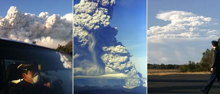
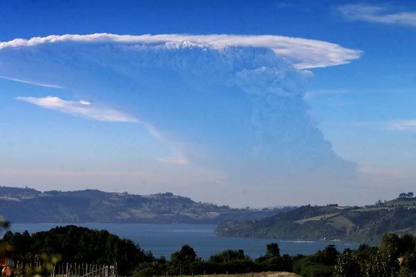
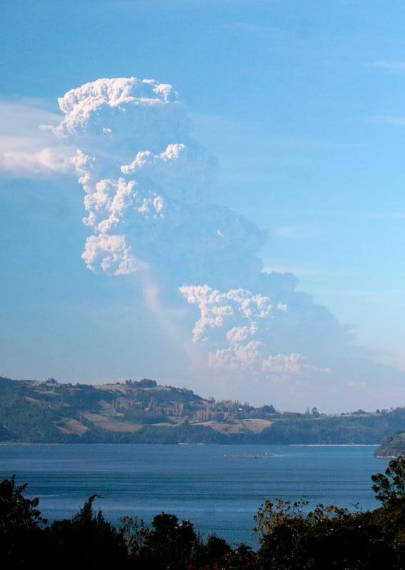
http://www.patagoniatimes.cl/content/view/485/1/quote:LONG DORMANT VOLCANO ERUPTS IN SOUTHERN CHILE
Authorities Clarify That Chaitén, Not Michimahuida, Erupted Friday
A volcano in southern Chile has awoken for the first time in recorded history, spewing a massive billow of ash that is visible as far away as Puerto Montt, some 150 kilometres to the north.
The 950-meter Chaitén Volcano, which lies approximately 10 kilometers from a town of the same name (Region X), began erupting early Friday morning. Smoke and ash from the eruption has made transit along Route 7 impossible, isolating Chaitén’s approximately 7,000 residents. Chaitén is a small coastal town located directly opposite the island of Chiloé.
“Ash began spewing out before the eruption and continues to do so,” said vulcanologist Luis Lara of Chile’s National Geologic and Mining Service (SERNAGEOMIN). “This ash can cause some serious problems. It’s not good to breathe these particles. Also, if too much accumulates, it can cause physical damage to homes, for example.”
So far approximately five centimeters of ash have collected in Chaitén, which according to city councillor Victor González was completely unprepared for the emergency.
“There are problems with lack of water,” he said. “The people are very worried. Many people are heading toward Palena, but the rest can’t go anywhere because we’re isolated. There are waiting lists for people trying to get out by boat. Planes can’t take off because of visibility problems.”
“Really, there’s nothing to do except conserve water and not go out in to the street,” he added. “The city’s dark. To face the problem there should been concrete measures, like distributing water and masks. The Navy should have ordered more ships to be here, because they take four or five, sometimes up to seven hours to reach here.”
The eruption has also affected the town of Futaleufu, located approximately 60 kilometers south-west.
“Ash from this morning’s volcanic eruption continues to fall lightly over the town of Futaleufu,” Javier Villegas of Radio Estrella del Mar told the Patagonia Times. “The community’s in a state of constant alert. People are being asked no to go outside unless necessary, not to drive – so as not to stir up ash that’s on the roads – and to collect water.”
Authorities originally believed the eruption originated in the nearby Michimahuida volcano, a 2,400-meter behemoth located some 40 kilometers north-west of Chaitén.
Luis Lara explained that Chaitén is a “cauldron” volcano and features a large crater with a dome inside. “It’s growing and collapsing in a constant state of eruption,” the SERNAGEOMIN said.
The Chilean Navy has dispatched a ship called the Cirujano Videla to help evacuate Chaitén residents. Flights, meanwhile, have been temporarily suspended in the area due to low visibility.
Op zaterdag 15 augustus 2009 23:05 schreef eer-ik het volgende:
Ik vind je sig nogal denigrerend.
Ik vind je sig nogal denigrerend.
Nog even een plaatje erbij! 

Op zaterdag 15 augustus 2009 23:05 schreef eer-ik het volgende:
Ik vind je sig nogal denigrerend.
Ik vind je sig nogal denigrerend.

quote:Evacuaties na uitbarsting vulkaan in Chili
PUERTO MONTT (ANP) - Zeker 4.000 mensen in Chili zijn geëvacueerd wegens een vulkaanuitbarsting dinsdag in de zuidelijke plaats Chaiten. De autoriteiten hebben de noodtoestand uitgeroepen.
Gebouwen en straten in de zuidelijke plaats Chaiten zijn bedekt onder een laag as. De vulkaan, die op 10 kilometer ligt van Chaiten, begon vrijdag te rommelen. Vulkanoloog Luis Lara zei dat de uitbarsting zeer gevaarlijk is en wel maanden kan duren.
De wind heeft de as honderden kilometers verderop geblazen tot in Argentinië. Daar hebben autoriteiten scholen, vliegvelden en wegen afgesloten. Ook wordt in enkele gebieden drinkwater gedistribueerd.


Dat zijn toch wel even mooie foto's!!
Hoe vervelend het voor de bewoners ook is...
Hoe vervelend het voor de bewoners ook is...
SPOILEROm spoilers te kunnen lezen moet je zijn ingelogd. Je moet je daarvoor eerst gratis Registreren. Ook kun je spoilers niet lezen als je een ban hebt.
[ Bericht 33% gewijzigd door OA op 06-05-2008 22:42:05 ]Op zaterdag 15 augustus 2009 23:05 schreef eer-ik het volgende:
Ik vind je sig nogal denigrerend.
Er is ook een filmpje, hier: http://julien-agence.monsite.wanadoo.fr/page6.htmlquote:
Commentaar erbij:
6/05/2008
L'activité du volcan Chaiten s'est accrue fortement aujourd'hui,produisant une importante colonne de cendre de 22km d'altitude et des flux pyroclastiques qui ont parcourus de grande distance,arrivant quasiment aux portes de la ville de Chaiten.A l'heure actuelle,l'éruption est toujours en cours est reste soutenue.
Voir ci-dessous la spectaculaire vidéo au moment ou son activité est à son maximum.Le niveau d'alerte reste maximum(Rouge)
Een beetje vrij zelf vertaald.
6/05/2008 De activiteit van de vulkaan Chaiten is vandaag sterk toegenomen, die een omvangrijke kolom van as met een hoogte van 22km hoogte produceert en de pyroclastische stromen hebben een grote afstand afgelegd, bijna tot de deuren van de stad Chaiten. Momenteel blijft de uitbarsting aanhouden. Zie hieronder de spectaculaire video op het moment dat de activiteit aan het maximum is.
Het niveau van het alarm blijft maximaal (Rood)
[ Bericht 30% gewijzigd door kahaarin op 07-05-2008 10:43:05 ]
be nice or go away
En niets over de vertaling, moet ik babbelfisch even aanslingeren?quote:
Wat mij trouwens erg opviel was de enorme snelheid waarmee de kolom as opsteeg, die stapelwolk ernaast is binnen de kortste keren ingehaald door de eruptie, dat is een snelheid waar menig auto een puntje aan kan zuigen volgens mij.
be nice or go away
Dank u, dank u!quote:
Is er nu al iets meer bekend over de schade en de gevolgen? Ik las dat de rook een heel end meegevoerd was, kan dat nog voor veel problemen zorgen?
be nice or go away
http://www.patagoniatimes.cl/content/view/490/1/quote:Government Officials Fear “Worst Case Scenario”
The ongoing eruption of southern Chile’s Chaitén Volcano intensified significantly Tuesday as authorities for the first time reported seeing lava emanating from the volcano’s crater. The increasing volcanic activity prompted government authorities to order mandatory evacuation of local residents and all emergency workers.
“It’s a worst case scenario (for Chaitén),” an official from Chile’s National Emergency Office (ONEMI) told the Santiago Times.
Government officials put the coastal town of Chaitén (Region X), located just 10 kilometers from the erupting volcano, under a “red alert” at 8:45 a.m. after noticing pyroclastic flows coming from the volcano’s crater.
The U.S. Geological Survey Web site describes such flows as “high-density mixtures of hot, dry rock fragments and hot gases that move away from the vent that erupted them at high speeds.” The Web site says such events are capable of destroying by direct impact, burying surrounding areas with hot rock debris, melting snow and ice, and torching vegetation and nearby homes.
“If lava comes out of the volcano it would take 20 minutes to reach the town,'' said Chilean President Michelle Bachelet. “An evacuation mechanism has been set up that will allow us to save within 15 minutes the lives of the few residents and above all the members of the armed forces and police that are protecting and looking after Chaitén.”
In Chaitén, Navy ships were sent in to transport 384 people who initially refused to flee the eruption. The boats were set to travel across the Corcovado Gulf to Castro, on the island of Chiloé. By mid-afternoon, Chilean media reported the town was completely abandoned. Still, dozens of residents in the outlying community of Santa Bárbara, located nine kilometers outside Chaitén, refused to leave their homes.
Six buses, meanwhile, evacuated more residents from Futaleufu, located approximately 60 kilometers south-east of Chaitén. Police reported that areas in the town had as much as 30 centimeters of ash. As of press time, government officials were advising town residents to leave but had not declared a mandatory evacuation.
Officials were also studying the possibility of evacuating Palena, located near the border with Region XI, some 40 kilometers south of Futaleufu.
Local media reported that rocks propelled by the eruption were falling up to 20 kilometers away from the volcano and that clouds of toxic ash were drifting towards parts of Region XI. Acting Region XI Governor Ximena Órdenes put the towns of Puerto Cisnes and Lago Verde on “yellow alert,” thus freeing up emergency funds to help local authorities protect residents from the volcano's effects.
In total, some 12,000 area residents have already been evacuated, according to ONEMI.
Both Chaitén and Futaleufu have been blanketed in recent days by toxic volcanic ash, which began spewing from the Chaitén Volcano early Friday morning. This is the 950-meter volcano’s first eruption in recorded history.
Earlier this week President Michelle Bachelet visited the volcano zone accompanied by a team of U.S. scientists and several of her top cabinet ministers.
“We are traveling with a group of scientists from the United States who made an initial assessment of the situation yesterday,” Bachelet told reporters. “They are going to measure the air quality, as well as the presence of chemicals due to the falling ash. They are going to find out about the risks that exist.”
Of major concern is the effect the ubiquitous ash – which has contaminated local water supplies – will have on residents still in the area and on the region’s estimated 40,000 head of livestock.
The ongoing eruption has released a plume of smoke that continues to drift in a south-eastern direction across the Chile-Argentine border. NASA satellite photos released Tuesday afternoon showed the smoke reaching Atlantic coast of Argentina, located about 500 miles east of the eruption site.
Op zaterdag 15 augustus 2009 23:05 schreef eer-ik het volgende:
Ik vind je sig nogal denigrerend.
Ik vind je sig nogal denigrerend.

Die satellietbeelden, die as gaat gewoon van kust tot kust, jeutje, maar weer eens een bewijs dat de mensheid toch echt wel overgeleverd is aan de natuur, we kunnen met zijn allen wel van alles bedenken/bouwen en beschermen maar als puntje bij paaltje komt hebben we maar bijster weinig in te brengen.
be nice or go away
Zo zeg, dat komt ver!quote:
[b]Op maandag 6 september 2010 00:28 schreef tong80 het volgende:[/b]
GVD Wat moet jij een trotse vader zijn :)
:P
GVD Wat moet jij een trotse vader zijn :)
:P
Twee korte filmpjes:
http://news.bbc.co.uk/1/hi/world/americas/7386050.stm
http://news.bbc.co.uk/2/hi/7384992.stm
Nog twee foto's uit dezelfde spectaculaire scenery als hierboven
Eén (klik): http://www.lun.com/modulo(...)tm?tipoPantalla=1259
Twee:
En nog meer indrukwekkende foto's via de volgende link:
http://media.theaustralia(...)5-volcano/index.html
http://news.bbc.co.uk/1/hi/world/americas/7386050.stm
http://news.bbc.co.uk/2/hi/7384992.stm
Nog twee foto's uit dezelfde spectaculaire scenery als hierboven
Eén (klik): http://www.lun.com/modulo(...)tm?tipoPantalla=1259
Twee:

En nog meer indrukwekkende foto's via de volgende link:
http://media.theaustralia(...)5-volcano/index.html
As vulkaan bedreigt Buenos Aires
Dikke aswolken uit de vulkaan Chaiten in Chili hebben zich verspreid boven grote delen van Chili en Argentinië. De verwachting is dat de as voor grote problemen zal zorgen in de Argentijnse hoofdstad Buenos Aires.
Artsen waarschuwen voor het inademen van giftige deeltjes uit de as. Daardoor kunnen gezondheidsproblemen ontstaan in de miljoenenstad.
Dorpen in een straal van 50 kilometer rond de vulkaan zijn ontruimd. Zes dagen geleden barstte de Chaiten uit. Seismologen denken dat de uitbarsting nog maanden kan aanhouden. De vulkaan is duizenden jaren niet actief geweest
nos

quote:Government Vulcanologist Spells Out “Worst Case Scenario”
Chilean authorities are considering the possibility that Region X’s Chaitén Volcano, now in its sixth day of continuous eruption, might collapse and thus release a torrent of red-hot pyroclastic material – burning gas and rocks – that could devastate the surrounding area.
Very much a “worst case scenario,” the possibility is nevertheless a very real one, vulcanologist Luis Lara of Chile’s National Geologic and Mining Service (SERNAGEOMIN) told reporters Thursday afternoon.
“That’s precisely the reason we recommended that authorities define a restricted area, because this is a real possibility with volcanoes that are similar to Chaitén. We can’t offer any kind of probability that this will happen, or say for sure how things will play out. It’s a worst case scenario,” said Lara.
There is indeed precedent for such concern, according to the SERNAGEOMIN official, who pointed out that similar volcanoes – in Mexico and the Philippines, for example – have collapsed on the seventh or eight day of continuous eruption. Friday will mark the Chaitén Volcano’s seventh day of eruption.
“Pompeii is in some ways similar,” said Lara, referring to the Roman city famously destroyed in AD 79 by Mount Vesuvius. “There was a pyroclastic flow that resulted in the consequences we all know. That’s exactly the worst case scenario that we’ve defined here.”
Pyroclastic flows are rapid currents of hot gas and rock that can escape from a volcano crater and travel downhill toward surrounding areas. Lara and his colleagues, in fact, have already observed such pyroclastic escapes in photographs and video recordings of the ongoing Chaitén eruption.
“There’s evidence that this is happening. One can see pyroclastic flows descending past the edge of the dome, where the craters are located. Although they aren’t very dense and are of relatively small volume, they’re crashing against the walls of the cauldron and have burned vegetation in this part,” said Lara.
The vulcanologist suspects such flows are responsible for a noted temperature increase (of between 7 and 17 degrees Celsius) in the nearby Chaitén and Raya Rivers.
The eruption, Chaitén’s first in recorded history, released a massive billow of ash that was visible as far away as Puerto Montt, some 200 kilometers to the north. Volcanic soot began to rain down, blanketing Chaitén and other area towns such as Futaleufú, and contaminating local water supplies.
The volcanic activity intensified between Tuesday and Thursday as authorities reported seeing lava emanating from the volcano’s crater. The natural disaster prompted government officials to order the mandatory evacuation of local residents and all emergency workers within 50 kilometers of the volcano.
So far the volcano has emitted an estimated two cubic kilometers of ash, said Lara. Smoke from the crater has shot up as high as 15 kilometers. The massive plume of smoke, furthermore, now stretches as far away as Buenos Aires, Argentina, arpproximately 500 kilometers to the east.
The Chilean government on Thursday announced a series of tax-relief measures for victims of the Chaitén Volcano eruptions. Officials disclosed their plans as the Chilean military evacuated the remaining residents holed up in rural towns surrounding the volcano.
The eruption, which began early Friday morning, released a massive billow of ash that was visible as far away as Puerto Montt, some 200 kilometers to the north. Volcanic soot began to rain down, blanketing Chaitén and other area towns such as Futaleufú, and contaminating local water supplies (ST, May 5). NASA satellite photos released several days later showed the cloud of smoke spreading towards Argentina's Atlantic coast, some 500 miles to the east.
Still, a small group of civilians refused to leave two villages surrounding Chaitén, a municipality located 10 kilometers from the exploding volcano with the same name. The group included local radio show host Bernardo Riquelme, who refused to stop broadcasting for the few inhabitants left behind. All citizens were finally evacuated after government officials threatened to extract them from their homes by force.
Meanwhile, Chile's Tax Service (SII) announced a “huge tax pardon” for all inhabitants affected by the volcano. Accompanied by Finance Ministry officials and government Treasurer Pamela Cuzmar, SII President Ricardo Escobar said the plan calls for erasing all interest on residents' debts and exempting them from paying property taxes for at least four years. He said the measures alone will allow area residents to save a total of Ch$1.3 billion pesos (US$2.8 million).
“We have decided to take measures that we believe are appropriate for a disaster of this magnitude,” affirmed Finance Ministry Undersecretary María Olivia Recart. “They are exceptional measures, and they will go a long way to alleviating the stressful situation facing many local residents.”
Chile has one of the world's most active string of volcanoes. It is home to some 2,000 volcanoes, 500 of which experts say are potentially active. Around 60 have erupted over the past 450 years.
Op zaterdag 15 augustus 2009 23:05 schreef eer-ik het volgende:
Ik vind je sig nogal denigrerend.
Ik vind je sig nogal denigrerend.
Waarom niet? Ben jij geoloog?
Op zaterdag 15 augustus 2009 23:05 schreef eer-ik het volgende:
Ik vind je sig nogal denigrerend.
Ik vind je sig nogal denigrerend.
Nee maar er is weer eens een vulkaan actief... en één iemand houdt rekening met het ergste scenario... tja dat is altijd wel denk ik

De tekenen zijn hetzelfde als bij uitbarstingen die elders hebben plaatsgevonden. Dan is het natuurlijk makkelijk om een vergelijking te maken én mensen houden wel van doemdenken.
Het is iig niet op niks gebaseerd.
Het is iig niet op niks gebaseerd.
Op zaterdag 15 augustus 2009 23:05 schreef eer-ik het volgende:
Ik vind je sig nogal denigrerend.
Ik vind je sig nogal denigrerend.
ERUTPION PAROXYSMALE DU VOLCAN CHAITEN
Le volcan est entré hier matin dans une phase éruptive paroxysmique,engendrant une très forte émission de cendre jusqu'à 30km d'altitude et de grosses nuées ardentes,détruisant une grande quantitée de la forêt qui recouvrait la région.L'alerte est maximale(Rouge) et tous les habitants vivant dans un rayon de 50km ont été évacués.Les deux petis cratères qui occupaient la caldeira avant l'éruption,ont fusionné, ne formant + qu'un grand cratère.Sources:Romandie-news;TF1.fr;Activolcans
Kan iemand mij zeggen wat dit is? "une phase éruptive paroxysmique"
Dan kan ik dat stukje vertalen, er zat ook weer een filmpje bij.
http://julien-agence.monsite.wanadoo.fr/page6.html
be nice or go away

een plotselinge (aanval van) eruptieve fase.quote:Op vrijdag 9 mei 2008 11:52 schreef kahaarin het volgende:
ERUTPION PAROXYSMALE DU VOLCAN CHAITEN
Kan iemand mij zeggen wat dit is? "une phase éruptive paroxysmique"
Dan kan ik dat stukje vertalen, er zat ook weer een filmpje bij.
http://julien-agence.monsite.wanadoo.fr/page6.html
Op zaterdag 15 augustus 2009 23:05 schreef eer-ik het volgende:
Ik vind je sig nogal denigrerend.
Ik vind je sig nogal denigrerend.
Translation: Frans » Nederlandsquote:Op vrijdag 9 mei 2008 11:52 schreef kahaarin het volgende:
ERUTPION PAROXYSMALE DU VOLCAN CHAITEN
Le volcan est entré hier matin dans une phase éruptive paroxysmique,engendrant une très forte émission de cendre jusqu'à 30km d'altitude et de grosses nuées ardentes,détruisant une grande quantitée de la forêt qui recouvrait la région.L'alerte est maximale(Rouge) et tous les habitants vivant dans un rayon de 50km ont été évacués.Les deux petis cratères qui occupaient la caldeira avant l'éruption,ont fusionné, ne formant + qu'un grand cratère.Sources:Romandie-news;TF1.fr;Activolcans
Kan iemand mij zeggen wat dit is? "une phase éruptive paroxysmique"
Dan kan ik dat stukje vertalen, er zat ook weer een filmpje bij.
http://julien-agence.monsite.wanadoo.fr/page6.html
De vulkaan heeft gisterochtend in een eruptive paroxysmale fase, waardoor een zeer sterke emissie van as tot 30 km hoogte en grote wolken branden, vernietiging van een grote hoeveelheid van het bos, dat betrekking had op de regio. De signalering is maximaal (Red) en alle inwoners wonen in een straal van 50km werden geëvacueerd. De twee kleine kraters die bezet de caldera vóór de uitbarsting, zijn gefuseerd en vormen + heeft een grote krater. Bronnen: Romandie-nieuws; TF1.fr; Activolcans
Google Translate, erg fijn
Ah thnx!quote:Op vrijdag 9 mei 2008 11:58 schreef OA het volgende:
[..]
een plotselinge (aanval van) eruptieve fase.
De vulkaan is gisterochtend een plotselinge eruptieve fase ingegaan, en een zeer sterke uitstoot van as tot 30km hoogte en hevige vurige wolken zijn het gevolg, daardoor is een grote oppervlakte van het bos vernietigd, er is rood alarm geslagen en alle inwoners wonend in een straal van 50km van de 2 kleine kraters zijn geevacueerd, de 2 kleine kraters zijn gefuseerd en vormen nu 1 grote krater.
be nice or go away
Frans lezen lukt wel ik wist alleen niet wat dat dikgedrukte stukje betekende, en google translate ook niet blijkbaar!quote:Op vrijdag 9 mei 2008 12:00 schreef Bakakame het volgende:
[..]
Translation: Frans » Nederlands
De vulkaan heeft gisterochtend in een eruptive paroxysmale fase, waardoor een zeer sterke emissie van as tot 30 km hoogte en grote wolken branden, vernietiging van een grote hoeveelheid van het bos, dat betrekking had op de regio. De signalering is maximaal (Red) en alle inwoners wonen in een straal van 50km werden geëvacueerd. De twee kleine kraters die bezet de caldera vóór de uitbarsting, zijn gefuseerd en vormen + heeft een grote krater. Bronnen: Romandie-nieuws; TF1.fr; Activolcans
Google Translate, erg fijn
Maar goed, volgens mij snap ik het nu wel.
be nice or go away

Chaiten Volcano Erupts
On May 2, 2008, Chile’s Chaitén Volcano erupted, sending plumes some 30 kilometers (18.6 miles) skyward, and blanketing some nearby areas in as much as 1.5 meters (5 feet) of volcanic ash. In the week that followed the initial eruption, local authorities established an evacuation zone with a radius of 50 kilometers (31 miles) around the volcano, warning holdouts that they would be evacuated by force, if necessary.
On February 21, 2000, the Enhanced Thematic Mapper on NASA’s Landsat satellite captured the volcano in a state of calm. In this image, the volcano’s caldera appears as a pale brown crater inside an ocean of lush green vegetation that covers the mountainous region. To the southwest is the nearby coastal town with the same name as the volcano. The satellite’s view is obscured only by the occasional cloud.
The tranquility of the volcano apparent in this image has been the norm throughout recorded human history. The May 2008 eruption was a surprise—Chaitén’s first eruption in more than 9,000 years. Even when a volcano has been active in recent history, the surrounding areas often provide good reasons to settle, including fertile soils and milder climates arising from high altitudes (at least in the tropics).
Vulkaan Etna is weer uitgebarstenquote:Op het Italiaanse eiland Sicilië is de vulkaan Etna weer uitgebarsten. Sinds 15:00 uur vanmiddag stroomt er lava uit een krater aan de zuidoostelijke kant van de vulkaan het gebied Valle del Bove in. Volgens het Instituut voor geofysica en vulkanologie, dat gevestigd is in Palermo, is het gebied waar de lava stroomt onbewoond.
De Etna is de op één na actiefste vulkaan van Europa. De vorige uitbarsting is nog niet zo lang geleden en dateert van september 2007. De uitbarsting ging toen gepaard met vliegende rotsblokken, waardoor het nabij gelegen vliegveld van Catania werd gesloten. De zwaarste uitbarsting van de laatste jaren vond plaats in 2001; de regering riep toen de noodtoestand uit.
Op zaterdag 15 augustus 2009 23:05 schreef eer-ik het volgende:
Ik vind je sig nogal denigrerend.
Ik vind je sig nogal denigrerend.
http://www.patagoniatimes.cl/content/view/501/1/quote:CHILE VOLCANO ZONE MAY BE PERMANENTLY UNLIVABLE
Chilean President Michelle Bachelet on Saturday warned that towns surrounding Region X’s Chaitén Volcano, which has been in constant eruption since May 2, might become permanently unlivable. Bachelet's remarks came after the National Geologic and Mining Service (SERNAGEOMIN) delivered her an ominous report putting the possibility of the volcano's collapse above 50 percent.
“There are experts who say that lava from the Chaitén Volcano could flow directly towards the town of Chaitén,” said Bachelet. “These experts are recommending that the town of Chaitén never be inhabited again.”
SERNAGEOMIN vulcanologist Luis Lara first disclosed on Thursday that the volcano could implode, thus releasing a streatm of red-hot pyroclastic material (burning gas and rock) capable of destroying everything in its path. Pyroclastic flows are rapid currents of hot gas and rock that can escape from a volcano crater and travel downhill toward surrounding areas.
The Chilean daily La Tercera reported on Sunday that a SERNAGEOMIN study had put the odds of such a collapse as at least 50 percent. The document said that there was increased build-up in the dome of magma currently covering the volcano's crater. Futhermore, the material accumulating in the area was “highly dense,” and thus more prone to collapse. SERNAGEOMIN said that any implosion would cause complete destruction of everything within a 15 kilometer radius around the peak, an area which encompasses Chaitén, Santa Barbara, and several rural farming villages.
Bachelet, who had returned on Friday to the area affected by the eruption, acknowledged this threat while touring the town of Palena.
“The people (who live in the area around the volcano) represent our top priority right now,” Bachelet said. “This tremendous column of burning rock and magma could reach speeds of between 100 and 400 kilometers per hour. At that rate, it could reach the town of Chaitén in six minutes.”
Still, Bachelet said that not all scientists agreed on the possibility of such an event, adding that some officials had even suggested that local communities covered in ash by the volcano blasts could be fully functional within a few years.
“We have never had a situation quite like this in Chile,” she said.
The eruption, Chaitén’s first in recorded history, released a massive billow of ash that was visible as far away as Puerto Montt, some 200 kilometers to the north. Volcanic soot began to rain down, blanketing Chaitén and other area towns such as Futaleufú, and contaminating local water supplies.
The volcanic activity intensified between Tuesday and Thursday as authorities reported seeing lava emanating from the volcano’s crater. The natural disaster prompted government officials to order the mandatory evacuation of local residents and all emergency workers within 50 kilometers of the volcano (ST, May 8).
More than 12,000 civilians were evacuated by week's end, including a few dozen residents holed up in Chaitén and Santa Barbara. The Agriculture Ministry had also initiated plans to rescue most of the 40,000 cows, sheep, and other livestock in nearby towns.
Still, the Region X Governor's Office issued a decree preventing animal rights organizations from traveling to Chaitén in order to rescue an estimated 600 pets, mostly horses, dogs and cats. As of Sunday, local animal activists said that they were preparing legal arguments in order to have the decision overturned. Bloomberg reported that the U.S. Human Society had announced plans to send a team to Chaitén, described as “a city overtaken by dogs.” Meanwhile, more than 600 pets in Futaleufú were being successfully aided by volunteers.
New evidence suggests that southern Chile’s Monte Verde archaeological site, located some 35 kilometers from Puerto Montt (Region), is approximately 14,000 years old, making it the oldest known human settlement in the Americas.
The new findings, published this week in Science Magazine, confirm what researchers studying the site have suspected for years: that early migrants to the Americas made their way south far earlier than previously thought. The evidence goes in the face of a long-standing theory among U.S. archaeologists that the first visitors to the Americas – the Clovis people – crossed the Russia-Alaska land bridge (now the Bering Straight) some 13,000 years ago.
University of Vanderbilt archaeologist Tom Dillehay and others studying the Monte Verde site, which was discovered by accident in 1976, identified nine different types of algae used by settlers as both food and medicine. Using carbon dating techniques, the scientists determined the material to be between 14,220 and 13,980 years old – roughly 1,000 years older than any other known settlement in the hemisphere.
“These findings support the archaeological interpretation of the site and indicate that the site's inhabitants used seaweed from distant beaches and estuarine environments for food and medicine. These data are consistent with the ideas that an early settlement of South America was along the Pacific coast and that seaweeds were important to the diet and health of early humans in the Americas,” an abstract for the Science article reads.
Researchers believe the early settlement supported some 25 community members. At the time, suggest Dillehay and his colleagues, the nearby island of Chiloé was likely connected to the Chilean mainland.
Op zaterdag 15 augustus 2009 23:05 schreef eer-ik het volgende:
Ik vind je sig nogal denigrerend.
Ik vind je sig nogal denigrerend.
maar zonder dat de magmakamer leeg wordt "geërupteerd"?quote:the possibility of the volcano's collapse above 50 percent.
Past dit wel hier, of is een nieuw topic beter op z'n plaats?
quote:Gedurfde hypothese: aardse kernreactie
Een kernreactie diep in de aarde genereert warmte die vulkanen doet uitbarsten. Deze afwijkende hypothese durfden de gerenommeerde tijdschriften niet aan.
Rotterdam, 22 mei. Diep in de aarde, langs de buitenkant van de aardkern, ligt een natuurlijke kernreactor verscholen die duizend keer krachtiger is dan de grootste kerncentrale. Het uranium, de splijtstof die nodig is voor deze reactie, ligt opgesloten in een laag superzwaar gesteente van maximaal een paar honderd kilometer dik. De splijtingsproducten van kernreacties op circa drieduizend kilometer diepte kunnen de afwijkende samenstelling verklaren van vloeibaar gesteente dat aan het aardoppervlak komt op vulkanische eilanden als Hawaii en Réunion en langs spreidingsruggen op de oceaanbodem.
Rob de Meijer, emeritus hoogleraar nucleaire fysica aan de Rijksuniversiteit Groningen en aardwetenschapper Wim van Westrenen (VU Amsterdam) publiceren deze opmerkelijke hypothese in een artikel dat binnenkort verschijnt in het South African Journal of Science. „Een relatief obscuur tijdschrift”, erkent Van Westrenen. „Maar we zagen geen andere mogelijkheid. Als je een kernreactor in de aarde veronderstelt, dan kan dat verregaande consequenties hebben.
„Wij denken dat een uit de hand gelopen kernreactie in het binnenste van de aarde 4,5 miljard jaar geleden kan hebben geleid tot het ontstaan van de maan. We hebben daarover een artikel aangeboden aan Nature en daarna aan Geophysical Research Letters, maar de referenten vonden het te veel ineens. Onze ideeën zingen nu rond en het leek ons verstandig om ten minste een deel ervan te publiceren voordat iemand anders ermee op de loop gaat.” Pikant: maandag besteedde Nature op haar website aandacht aan de Nederlandse studie waarvoor haar wetenschappelijke referenten eerder de neus ophaalden.
Gebergte
Van Westrenen stelt zich het gesteente met de splijtstof voor als een ‘gebergte’ op de buitenkern van de aarde. De bergtoppen steken in de diepe mantel omhoog. De diepe mantel is de circa 3.000 kilometer dikke aardlaag tussen de aardkern en de buitenste laag: de aardkorst.
Bekend is dat instabiele elementen in de aardmantel vervallen en warmte produceren. Dit proces is een belangrijke motor achter de stromen van opwarmend en afkoelend gesteente in de aardmantel en uiteindelijk vulkanisme. Een echte kernreactie gaat verder en kan ontstaan als voldoende van de kerndeeltjes die vrijkomen uit een radioactief element als uranium of thorium andere kernen raken en een kettingreactie veroorzaken.
Dat natuurlijke kernreacties op aarde kunnen ontstaan, was bekend. In Gabon zijn resten gevonden van een twee miljard jaar oude natuurlijke kernreactor. Dat de metalen kern van de aarde een kernreactor zou herbergen, is in de jaren tachtig al geopperd door de Amerikaan Marvin Herndon, maar Van Westrenen is daar sceptisch over. „De aardkern bestaat uit ijzer en nikkel. Een radioactief element als uranium lost daarin niet makkelijk op.”
De Nederlanders hebben uitgerekend hoeveel uranium past in gesteente op zeer grote diepte. Calciumsilicaatperovskiet, één van de mineralen die onder hoge druk ontstaan, zou in zijn kristalstructuur zoveel uranium op kunnen nemen dat de voor een kernreactie benodigde kritische massa ontstaat.
Verborgen
Een diepe kernreactor zou de hoge concentratie kunnen verklaren van varianten van elementen als xenon en helium in vulkanische gesteenten als basalt. Van Westrenen: „Uit een studie in Science uit 2005 blijkt dat uitvloeiingsgesteenten als basalt, die hun oorsprong in de aardmantel vinden, minder zeldzame aardmetalen bevatten als neodymium, en ook minder uranium dan meteorieten die we op aarde vinden. Omdat geologen ervan uitgaan dat de aarde en meteorieten – net als de rest van ons zonnestelsel – uit hetzelfde materiaal bestaan, moet de rest ergens in een aards reservoir verborgen zitten.”
De laag zwaar gesteente met de kernreactor zou dat diepe reservoir kunnen zijn en meteen verklaren waarom varianten van xenon en helium in vulkanisch gesteente wél in ruime mate aanwezig zijn. Deze isotopen zijn precies de splijtingsproducten die vrijkomen bij kernreacties met thorium en uranium.
Of de hypothese standhoudt, zal duidelijk worden als wetenschappers meer te weten komen over de herkomst van anti-neutrino’s, deeltjes die bij kernreacties vrijkomen. Met een detector in Japan is in 2005 voor het eerst vastgesteld dat deze deeltjes niet alleen ontstaan in het heelal, maar ook in de aarde. De Meijer werkt aan een proefopstelling voor een reeks detectoren waarmee hij het bestaan van de diepe kernreactor uiteindelijk zou kunnen bewijzen.

Op zaterdag 15 augustus 2009 23:05 schreef eer-ik het volgende:
Ik vind je sig nogal denigrerend.
Ik vind je sig nogal denigrerend.
Nieuw topic denk ik beter.. boeiende materie iig..quote:Op vrijdag 23 mei 200808:14 schreef OA het volgende:
Past dit wel hier, of is een nieuw topic beter op z'n plaats?
[..]
[afbeelding]
interessant stukjequote:Op vrijdag 23 mei 2008 08:14 schreef OA het volgende:
Past dit wel hier, of is een nieuw topic beter op z'n plaats?
[..]
[ afbeelding ]
misschien wel een eigen topic waard ja
[b]Op maandag 6 september 2010 00:28 schreef tong80 het volgende:[/b]
GVD Wat moet jij een trotse vader zijn :)
:P
GVD Wat moet jij een trotse vader zijn :)
:P

Is er alquote:Op vrijdag 23 mei 2008 10:02 schreef Againzender het volgende:
[..]
interessant stukje
misschien wel een eigen topic waard ja
Op zaterdag 15 augustus 2009 23:05 schreef eer-ik het volgende:
Ik vind je sig nogal denigrerend.
Ik vind je sig nogal denigrerend.
Nog altijd verhoogde activiteit Semeru vulkaan
quote:25 mei 2008 - De activiteit van de Semeru vulkaan bij Lumajang in oostelijk Java is nog altijd relatief hoog. Gebaseerd op seismische informatie van de observatiepost Gunung Sawur in het dorp Sumber Wulu, subdistrict Candipuro; er zijn 90 vulkanische trillingen, zeven magmatisch trillingen en 30 tectonische trillingen waargenomen in de afgelopen 24 uur.
Is dat bij jou in de buurt?quote:Op maandag 26 mei 2008 11:35 schreef indahnesia.com het volgende:
Nog altijd verhoogde activiteit Semeru vulkaan
[..]
be nice or go away
Neuh, een deur of twee verder dan de Keludquote:
quote:Op maandag 26 mei 2008 17:24 schreef indahnesia.com het volgende:
[..]
Neuh, een deur of twee verder dan de Kelud
Hopelijk niet natuurlijk maar als hij gaat ga jij dan ook?
be nice or go away
moah, deze vulkaan rommelt altijd wel een beetje, maar als het erger wordt is het misschien wel mooi te gaan ja.. ik houd het dus in de gaten.quote:Op maandag 26 mei 200820:42 schreef kahaarin het volgende:
[..]
[afbeelding] Kijken of deze wel wil? [afbeelding]
Hopelijk niet natuurlijk maar als hij gaat ga jij dan ook? [afbeelding] Foto's maken bedoel ik hoor, niet uitbarsten. [afbeelding]
Door die nieuwe berichten over andere vulkanen sneeuwt de Chaiten een beetje onder, dit zijn de berichten van gisteren, er heeft zich dus opnieuw een krater gevormd, er word nog steeds as uitgestoten en het stadje is ondergelopen, wordt vervolgd dus.
5e bericht ongeveer.
http://julien-agence.monsite.wanadoo.fr/page6.htmlquote:De uitbarsting van de Chileense vulkaan Chaiten gaat nog steeds door. De nieuwe krater, die zich op de zijkant van de vorige krater bevind, stoot een +/- 7000m hoge aswolk uit . De autoriteiten hebben besloten het rode alarm te vervangen voor oranje voor de luchtvaart. De stad Chaiten is volledig bedekt door modderig water. Het risico op een grote uitbarsting is er nog steeds, er blijft 24 uur per dag toezicht.
26/05/2008 CHAITEN
L'éruption du volcan Chilien Chaiten se poursuit.Le nouveau dôme de lave qui croit sur le flanc du précédent dôme émet une importante colonne de cendre haute de 7000m environ.Les autorités ont donc décidés d'abaisser le niveau d'alerte du Rouge à l'orange pour l'aviation.La ville de Chaiten est complètement noyée sous les eaux boueuses.Le risque d'une grande éruption n'est toujours pas écartée, la surveillance se fait 24/24h.A suivre...
5e bericht ongeveer.
be nice or go away
Sidoarjo moddervulkaan kan wellicht instorten
quote:De Indonesische moddervulkaan lijkt uit zichzelf ineen te storten, dit blijkt uit een nieuw onderzoek waarvan de resultaten op de tweede verjaardag van deze immer groeiende natuurramp werden gepresenteerd. Iedere dag komt er meer dan 100.000 kubieke meter hete, stinkende modder omhoog uit de moddervulkaan, welke twee jaar geleden actief werd tijdens een diepe boring in een nabije onderzoeksbron.
Vulkaanuitbarsting op Galapagos-eilanden
Op de Galapagos-eilanden is dit weekeinde een vulkaan uitgebarsten. De Cerro Azul spuwt na tien jaar rust weer lava uit.
Gevaar voor de bijzondere populatie reuzenschildpadden van het eiland Isabella is er niet, aldus natuurbeschermers. Tijdens de laatste uitbraak, in 1998, takelden reddingswerkers met helikopters reuzenschildpadden uit de krater om hen te redden van de gloeiende lavastroom. Nu stroomt de lava echter de andere kant uit.
De Galapagos-eilanden horen bij Ecuador en liggen duizend kilometer ten westen van het Zuid-Amerikaanse continent. De Engelse bioloog Charles Darwin ontwikkelde zijn evolutietheorie nadat hij er de unieke dieren had onderzocht. De eilanden zijn dunbevolkt, maar de Verenigde Naties waarschuwden vorig jaar dat toerisme en immigratie de natuur van de archipel bedreigen.
Bron: FP (ANP)

Chaiten Volcano Erupts
Chile’s Chaitén Volcano continued releasing ash and steam on May 31, 2008. The Moderate Resolution Imaging Spectroradiometer (MODIS) on NASA’s Aqua satellite took this picture the same day. In this image, the plume blows toward the east, fanning out as it goes. The white color of the plume suggests that water vapor predominates. The red outline at the volcanic summit is a hotspot where the satellite has detected unusually high surface temperatures.
Clear skies over the coastline show that much of the land along the coast has assumed the gray-beige dullness characteristic of volcanic ash. A May 30 bulletin issued by Chile’s Servicio Nacional de Geología y Minería stated that recent winds had dispersed volcanic ash along Chile’s coast between Chaitén and Chumildén to the north. The report also stated that, although seismic activity at the volcano had decreased, the possibility of explosive eruptions and pyroclastic flows could not be ruled out.
caldera volcano formed by a collapse of the volcanic summit that creates a circular depression. Prior to its May 2008 eruption, the volcano had been dormant for more than 9,000 years.

In May 2008, the 4,000 residents of the fishing town of Chaitén were evacuated after the eruption of Chaitén Volcano 10 kilometers (5.4 miles) to the northeast. In addition to the threat of ashfall or an explosive eruption, the town is being flooded as ash and debris from the volcano choke the surrounding rivers.
A fresh delta now extends into the the harbor and Bahía Chaitén, once the gateway to Chile’s remote and rugged Palena Province and Pumalín National Park. (The size of the delta is exaggerated in this image, which was acquired at or near low tide). Mud also filled the river channel, forcing a slurry of ash and water over the banks of Río Blanco and through the town’s streets.
As of May 30, 2008 Chaitén Volcano continues to erupt, steadily spewing a column of ash and steam several kilometers into the air. Simultaneously, Chaiten’s lava dome continues to grow as thick lava emerges from the Earth.
quote:Moddervulkaan door boring
Mensen hebben geen invloed op vulkanen wordt vaak gedacht. In verreweg de meeste gevallen is dat ook zo, maar niet altijd. Op 29 mei 2006 vormde zich de moddervulkaan Lusi op oostelijk Java. Onderzoek van een internationaal team van wetenschappers wijst uit dat een gasboring op slechts 150-200 meter van de plaats van ontstaan van moddervulkaan de oorzaak is. Niet een aardbeving zoals werd gedacht. Dit is gepubliceerd in het tijdschrift Earth and Planetary Science Letters.
Moddervulkaan
Dit type vulkaan spuwt geen lava zoals de meeste vulkanen, maar ontdoet zich van gas en modder. Temperaturen zijn dan ook een stuk lager. Omdat de stroperigheid van de modder laag is, zeker ten opzichte van sommige lavatypes, hebben moddervulkanen een zeer lage helling. De vrijkomende gassen zijn vooral methaan (CH4), koolstofdioxide (CO2) en stikstof (N2). Moddervulkanen komen op het land en in de oceaan voor en worden op alle werelddelen gevonden. Ze ontstaan voornamelijk in gebieden waar koolwaterstoffen aanwezig zijn én in tektonisch actieve gebieden.
Oost-Java en Lusi
Java is onderdeel van een geologische depressie, die omgeven is door breuken (slenk). Daarnaast is Oost-Java rijk aan gas en olievelden. Deze worden dan ook volop geëxploiteerd door drie bedrijven. Ook moddervulkanen steken hun kop op in deze regio.
De naam van de moddervulkaan Lusi op Oost-Java is een samentrekking van Lumpur Sidoarja. Lumpur betekent modder en Sidoarja is de streek. Op 29 mei 2006 ontstond de moddervulkaan en hij is nog steeds actief. Pogingen om de vulkaan te stoppen zijn mislukt. Meer dan 6,5 km2 is bedekt onder de modder en meer dan 30.000 mensen zijn verhuisd, een ramp voor de regio. Gassen als methaan, koolstofdioxide en het giftige waterstofsulfide (HS) komen uit de vulkaan en de temperatuur van het modder loopt op tot 100°C.
Aardbeving als oorzaak?
Deze ramp lijkt op het eerste gezicht puur natuur. Modderstromen komen immers natuurlijk voor. De directe oorzaak zou de aardbeving in Yogyakarta zijn die op 27 mei 2006, twee dagen voor het ontstaan van de moddervulkaan, de omgeving schokte met een kracht van 6,3 op de schaal van Richter. Bovendien is bekend dat aardbevingen moddervulkanen veroorzaken. De oorzaak lijkt voor de hand liggend.
Toch ligt het niet zo eenvoudig. De afstand tot de moddervulkaan vanaf het epicentrum van de beving is maar liefst 250 km. Ook zijn er in de afgelopen dertig jaar zwaardere aardbevingen geweest, die ook nog eens dichterbij plaatsvonden. Er ontstonden toen geen moddervulkanen. Verder was de door de aardbeving van 27 mei 2006 ontstane verandering in grondwaterdruk te verwaarlozen. Daarnaast weerleggen de onderzoekers de theorie dat een breuk in de aardkorst opnieuw zou zijn geactiveerd door de aardbeving. De kracht van de beving was hiervoor te zwak.
Banjar Panji-1 gasboring
De echte oorzaak van de moddervulkaan is een gasboring door het bedrijf PT Lapindo Brantas, slechts 150-200 m van de plaats van ontstaan van de moddervulkaan. De boring ging tot een diepte van 2800 m, maar had vanaf 1100 m geen beschermend, drukwerend omhulsel meer. Enkele uren na de aardbeving van 27 mei werd besloten de boor en boorpijp terug te halen, omdat de aanwezige modder niet meer stroomde. Na stopzetten kwam vloeistof en gas in het ontstane gat. Het dichtmaken van het boorgat zorgde voor extra druk, waardoor op 29 mei 2006 uiteindelijk de moddervulkaan ontstond.
Hoe lang het uitbraken van modder en gas nog voorduurt is onbekend. Eénmaal de kurk eruit betekent dus grote problemen. Wie betaalt de rekening?...


http://www.kennislink.nl/web/show?id=206537
===================================
http://www.nrc.nl/wetensc(...)_Java_door_gasboringquote:Moddervulkaan Java door gasboring
Jakarta, 11 juni. De moddervulkaan die sinds mei 2006 het Indonesische eiland Java teistert, is veroorzaakt door gasboringen. Dat concluderen internationale onderzoekers in een artikel in Earth and Planetary Science Letters.
Het bedrijf Lapindo Brantas, dat in het gebied naar gas boort, heeft steeds gezegd dat een aardbeving de oorzaak was van de stinkende modder die al meer dan 50.000 mensen dakloos heeft gemaakt en hele dorpen heeft verzwolgen.
Deskundigen hebben steeds gezegd dat een boring van Lapindo de oorzaak was. De hete, stinkende modderfontein begon op 29 mei 2006, de dag dat Lapindo naar gas boorde. Het bedrijf van eigenaar Aburizal Bakrie, de Indonesische minister van Sociale Zaken en een van de rijkste zakenlieden van het land, wees een aardbeving bij Yogyakarta twee dagen voor de boring, als oorzaak aan. Bij die aardbeving kwamen 6.000 mensen om. Het epicentrum van de beving, met een kracht van 6.3 op de schaal van Richter, lag echter 250 kilometer van de moddervulkaan.
Volgens geoloog Michael Manga van de universiteit van Berkeley was de aardbeving niet zwaar genoeg om op zo’n afstand een dergelijke modderstroom op gang te brengen.
Richard Davies van de universiteit van Durham, die al eerder bedenkingen uitte over de verklaring van het gaswinningsbedrijf, zegt nu dat er op de dag voor de stroom op gang kwam een grote hoeveelheid gas en water in het boorgat kwam, waardoor de druk opliep en het water naar boven werd geduwd, samen met rotsblokken. Daardoor scheurde de bodem.
Nog steeds stroomt dagelijks zo’n 100.000 kubieke meter modder uit de scheur. Volgens geoloog Manga is het nauwelijks mogelijk de scheur te dichten.
Lapindo Brantas zegt bereid te zijn tot een „wetenschappelijk debat” over de oorzaak. Het bedrijf twijfelt echter aan de deskundigheid van het onderzoeksteam. De Indonesische regering schat de totale schade op meer dan 800 miljoen dollar en heeft Lapindo opgedragen de helft daarvan te betalen, deels in de vorm van een schadevergoeding aan de slachtoffers.
Op zaterdag 15 augustus 2009 23:05 schreef eer-ik het volgende:
Ik vind je sig nogal denigrerend.
Ik vind je sig nogal denigrerend.

Llaima (file photo) began spewing lava Tuesday morning
Photo courtesy of National Geology and Mineral Service de Chile
http://www.patagoniatimes.cl/content/view/573/1/quote:CHILE’S LLAIMA VOLCANO OOZES LAVA
Southern Chile’s Llaima volcano woke up early Tuesday morning from a short, six-month nap and is currently oozing a stream of lava that already stretches for nearly a kilometer.
The eruption began at roughly 4 a.m., six month to the date after the 10,530-foot Region IX volcano ushered in the new year with a spectacular show (PT, Jan. 3).
Lava flowing down the volcano’s western slope has extended approximately 800 meters, prompting authorities to so far evacuate approximately 25 people. Chile’s National Emergency Office (ONEMI) is particularly concerned about residents in the towns of La Selva and Danubio.
ONEMI is also preparing for the possibility that the lava flow, which melts snow and ice as it descends, could produce dangerous mudslides. Due to heavy cloud cover, Chilean authorities have so far been unable to conduct flyovers.
Region IX Governor Nora Barrientos has declared a yellow alert for the communities of Curacautin, Cunco, Melipeuco and Vilcun.
Chile is one of the most volcanically active countries in the world. Earlier this year a massive and prolonged eruption by Region X’s Chaiten volcano forced the complete evacuation of a nearby city of the same name. Ash from the volcano – combined with subsequent floods – have all but destroyed the town. The volcano, in the meantime, continues to smoke.
Op zaterdag 15 augustus 2009 23:05 schreef eer-ik het volgende:
Ik vind je sig nogal denigrerend.
Ik vind je sig nogal denigrerend.
http://www.patagoniatimes.cl/content/view/575/1/quote:VOLCANO ERUPTION PROMPTS RED ALERT IN CHILE
New eruptions from southern Chile's Llaima volcano forced Chile\s government to declare a ‘Red Alert’ Thursday for residents of nearby towns. The advancing lava flow is 50 meters wide and has already stretched more than 2 kilometers down the volcano’s slopes.
According to Chile’s National Emergency Office (ONEMI), the lava does not immediately threaten residents of the area but is headed directly towards the Calbuco River. Melting ice from the summit of the volcano could mix with the lava, reach the river and make it overflow, endangering the surrounding areas.
The Region IX volcano began to spit out lava early Tuesday morning after being dormant for six months. ONEMI initially declared an optional Yellow Alert evacuation for nearby residents. However, with Thursday's new eruptions, the agency began forcing residents to leave the towns of La Selva, Danubio and Las Mercedes and the Las Araucarias Ski Center.
Clear weather has allowed authorities to conduct flyovers to evaluate the situation at the volcano’s crater. ONEMI officials reported that there are two sources spouting smoke from the crater. Both columns of smoke – one white and the other a light gray color – are blowing eastward.
“The incident is more or less similar to what happened in February (Laima's last eruption), when lava came down on the same side of the volcano,” ONEMI volcano specialist Juan Cayupi told the Chilean daily La Nación. “But you can also see a dark stain on the side of the volcano, which indicates that a bit of ash has been falling.”
Cayupi explained that if more ash were to fall, it could contaminate air and possibly the Calbuco River. Still, he said the chances were slim and that the government evacuated the people closest to the volcano because of possible respiratory dangers.
ONEMI Director Carmen Fernández joined ONEMI personnel on site Thursday morning in Cherquenco to discuss further possible preventive actions. ONEMI says it has taken all the necessary action to prevent a situation similar to what occurred when Region X’s Chaitén volcano erupted. The Chaitén eruption destroyed the city of the same name with intense ash fall and subsequent floods (ST, May 2).
Region IX’s ONEMI office reports that 24 people remain in areas near the volcano. Local police and Chilean army officers remain on guard blocking access to the volcano to anyone who is not a part of emergency teams.
Op zaterdag 15 augustus 2009 23:05 schreef eer-ik het volgende:
Ik vind je sig nogal denigrerend.
Ik vind je sig nogal denigrerend.
Klik voor een filmpjequote:Lava waves 12 metres high have been gushing from Mount Kilauea in Hawaii.
Officials say the eruption which started on Sunday poses no danger to residents living nearby.
Op zaterdag 15 augustus 2009 23:05 schreef eer-ik het volgende:
Ik vind je sig nogal denigrerend.
Ik vind je sig nogal denigrerend.
http://news.orf.atquote:Vulkan in Alaska ohne Vorwarnung ausgebrochen
Praktisch ohne Vorwarnung ist auf einer Insel in Alaska ein Vulkan ausgebrochen. Die Eruption schleuderte gestern eine Aschewolke bis in mehr als 15.000 Meter Höhe, wie der Geophysiker Steve McNutt vom Vulkanzentrum in Alaska sagte.
Die neun Bewohner einer Ranch zehn Kilometer südlich des Vulkans Okmok Caldera riefen die Behörden über Satellitentelefon zu Hilfe. Ein Schiff brachte sie am Abend in Sicherheit. Sie berichteten von einem Gesteins- und Ascheregen. Der rund 1.000 Meter hohe Vulkan auf der Insel Umnak brach zuletzt 1997 aus. Erst wenige Stunden vor der Eruption stellten Seismologen eine Reihe kleinerer Beben fest.
http://ap.google.com/arti(...)cObQBWbS25QD91SPA8G0quote:Remote Alaska volcano erupts, spewing rock and ash
ANCHORAGE, Alaska (AP) — A volcano erupted Saturday with little warning on a remote island in Alaska, sending residents of a nearby ranch fleeing from falling ash and volcanic rock.
The Okmok Caldera erupted late Saturday morning, just hours after seismologists at the Alaska Volcano Center began detecting a series of small tremors.
The explosion flung an ash cloud at least 50,000 feet high, said geophysicist Steve McNutt.
Ten people, including three children, were at Fort Glenn, a private cattle ranch six miles south of the volcano on Umnak Island, located in the western Aleutians about 860 miles southwest of Anchorage.
They were later picked up by the fishing boat Tara Gaila, which responded to a Coast Guard request for emergency assistance. The Tara Gaila was taking them to Dutch Harbor, the Coast Guard said late Saturday night.
The ranch residents had managed to call military police on Kodiak Island on a satellite phone before losing their connection, according to the Coast Guard.
At the same time it issued the general request for assistance from boats in the area, the Coast Guard diverted the cutters Jarvis and Melon to head toward the scene from their patrols in the Bering Sea.
A rescue helicopter from the Melon responded but had to land in Dutch Harbor after flying through some volcanic ash, causing some damage to the aircraft, the Coast Guard said.
Coast Guard Petty Officer Lee Goldsmith said those at the ranch reported rock and ash falling around them.
Okmok is 60 miles west of the busy fishing port of Dutch Harbor on Unalaska Island. Ash was reported falling in the region, McNutt said.
Two planned flights from Unalaska were canceled in response to the eruption, said Jerry Lucas, a spokesman for PenAir, the primary airliner serving the area.
The 3,500-foot volcano last erupted in 1997, according to McNutt. The volcano has shown signs of increased activity during the last few months, he said.
Previous eruptions have typically produced lava flows, but the volcano center could not immediately determine if that had occurred in Saturday's explosion, McNutt said.
Op zaterdag 15 augustus 2009 23:05 schreef eer-ik het volgende:
Ik vind je sig nogal denigrerend.
Ik vind je sig nogal denigrerend.
| Forum Opties | |
|---|---|
| Forumhop: | |
| Hop naar: | |