WKN Weer, Klimaat en Natuurrampen
Lees alles over het onstuimige weer op onze planeet, volg orkanen en tornado's, zie hoe vulkanen uitbarsten en hoe Moeder Aarde beeft bij een aardbeving. Alles over de verwoestende kracht van onze planeet en tal van andere natuurverschijnselen.


In navolging van Hurricane Season 2004 Deel 1 Hurricane Season 2004 en Deel 2 Hurricane Season 2004 -- Part 2
en natuurlijk Hurricane Season 2005 Deel 1 Tropical Cyclone Season 2005 en Deel 2 Hurricane/Cyclone Season 2005 - Part 2
is hier dan het eerste topic voor Hurricane Season 2006 voor zowel Atlantische, Indische als Pacifische stormen. Ik heb besloten dan ook maar per 1-1-2006 met dit topic te gaan starten.
Algemene Info
met Hurricane Season bedoelden we in eerste instante de periode van 1 juni tot 30 november.
Deze periode wordt in het Atlantische basin en de Golf van Mexico gezien als het “Stormen-seizoen Naar aanleiding van documentairs over Hurricane Andrew 1992 en de newsberichten van de laatste jaren over o.a. Floyd, Stan, Katrina en Ivan beginnen we ook voor 2006 met een nieuw topic. Dit jaar wat vroeger dan normaal, want ook in Januari t/m mei komen er flink wat stormen voor in een ander deel van de wereld. Waarschijnlijk zal de kern van de discussie en de posts gaan over de periode 1-6-2006 t/m 30-11-2006. Daarvoor zal het wel niet storm gaan lopen
Hoe ontstaan ze?
op de site van Wikipedia kan je in het Nederlands nalezen hoe ze ontstaan en wat de belangrijkste energiebron is voor hun verwoestende kracht: het warme zeewater http://nl.wikipedia.org/wiki/Orkaan#Ontstaan
De BBC heeft er een interessante en leuke gif over gemaakt (met dank aan Roel)
http://news.bbc.co.uk/2/hi/science/nature/4588149.stm
Indeling en Kracht
De stormen worden ingedeeld op categorie. Vaak zijn het eerst "tropische stormen" (Tropical Depression, Tropical Storms), die overgaan op Orkaanstatus (Hurricane) Ze worden ingedeeld op windsnelheden via de Saffire Simpson Schaal
Tropical Depression 24-38 mph winds (38-61 km/u)
Tropical Storm 39-73 mph winds (62-118 km/u)
Hurricane Categorie 1 74-95 mph winds (119-153 km/u) -- 4/5 ft Storm Surge -- Vb. Danny 1997, Stan 2005
Hurricane Categorie 2 96-110 mph winds (154-177 km/u) - 6/8 ft Storm Surge -- Vb. Danielle 2004
Hurricane Categorie 3 111-130 mph winds (178-209 km/u) -- 9/12 ft Storm Surge -- Vb.Fran 1996, Beta 2005
Hurricane Categorie 4 131-155 mph winds (210-249 km/u) -- 13/18 ft Storm Surge -- Vb.Hugo 1989, Frances 2004
Hurricane Categorie 5 > 156 mph winds (meer dan 250 km/u) -- 18ft or more S.S. -- Vb.Andrew 1992, Mitch 1998 en Wilma, Katrina 2005
Namen
De stormen, die vaak gevormd worden op de atlantische oceaan en dan richting de Caribbean of de Oostkust van de VS gaan, krijgen de naam op Alfabetische volgorde. Voor het seizoen 2005 zijn de namen als volgt:
Atlantische Stormen 2006
Alberto, Beryl, Chris, Debby, Ernest, Florence, Gorden, Helene, Isaac, Joyce, Kirk, Leslie, Michael, Nadine, Oscar, Patty, Rafael, Sandy, Tony, Valerie, William
In het oosten van de pacific ontstaan ook Hurricanes, ook wel Cylonen en/of Tyfoons genoemd. Deze zorgen vaak voor weinig schade aan de Amerikaanse westkust.
Oost Pacifische Stormen 2006
Aletta, Bud, Carlotta, Daniel, Emilia, Fabio, Gilma, Hector, Ileana, John, Kristy, Lane, Miriam, Norman, Olivia, Paul, Rosa, Sergio, Tara, Vicente, Willa, Xavier, Yolanda, Zeke
Verder zijn er dan nog de stormen in het Noorden, Zuiden en Westen van de Pacific. Met name de stormen in het Noord/Westen komen vaak in het nieuws omdat ze Japan, Taiwan en China vaak teisteren, maar ook geheel Zuid Oost Azie kunnen treffen. De namen van deze stormen zijn terug te vinden op [url] [url=http://www.nhc.noaa.gov/aboutnames.shtml[url]]http://www.nhc.noaa.gov/aboutnames.shtml[url][/url]
Wanneer zijn die seizoenen nou precies?
ATLANTIC: 1 mei t/m 30 november
NORTH EAST PACIFIC Begin mei t/m begin November, met piek in Augustus/September
NORTH WEST PACIFIC Begin juli t/m eind November, maar eigenlijk hele jaar door aktieviteit.
NORTH INDIAN April t/m December met pieken in Mei en November
SOUTH INDIAN + WEST AUSTRALIAN Oktober t/m Mei met pieken in Februari en April
SOUTH WEST PACIFIC + EAST AUSTRALIANOktober tot eind April met piek in Februari.
Over het algemeen is Mei de rustigste maand en September de ergste.
Hoe ziet de voorspelling voor 2006 eruit
Volgens Phil Klotzbach en William Gray van CSU wordt ook 2006 een behoorlijk geweldadig jaar. Ze houden rekening met 17 stormen, waarvan 9 hurricanes worden en 5 zeer zware hurricanes, met een kans van 81% dat de VS door in elk geval 1 van de ‘big ones’ geraakt wordt. Meer info over deze voorspelling vindje hier http://hurricane.atmos.colostate.edu/Forecasts/2005/dec2005/
Enkele Links
1. Hurricane Season Special Edition Pagina van CNN voor 2005
2. National Hurricane Centre
3. Carribean Storm Network
4. Florida University Hurricane Website
5. Action News from Florida + Webcams
6. Hurricane Track
7. Website met satelietbeelden van de Caribbean en de rest van Amerika
8. Intellicast: Geavanceerde satellietfoto's en gifs van aktuele stormen
9. Data over temperatuur / wind
10. Tropical Storm Risico's van dit moment
11. Actuele Watertemperatuur van dit moment
12. Wikipedia Hurricanes/Tyfonen in het algemeen
13. Overzicht aktuele typhoons in de pacific
14. Alle stormen ter wereld van de laatste jaren in overzicht
Opmerkelijke Links
-- Hurricane Katrina CNN Special Report of the Killer Hurricane
-- Hurricane Katrina via WikiPedia
-- Hurricane Season 2005 -- Special van CNN
-- Hurricane Season 2004 -- Special van CNN
– Overzicht van Atlantische Stormen uit 2005
-- Spectaculaire Satelietshots van stormen
--Animatie van de alle Atlantische Stormen uit 2004
Openingspost
Klik hier
Actuele Radar in Golf van Mexico

=====================
Post hier je gegevens, nieuwsberichten, data en/of opmerkelijke zaken over de ‘Hurricanes en Cyclonen’ van 2006.
[ Bericht 1% gewijzigd door Alicey op 21-07-2006 20:51:07 ]
Voor dit jaar ziet ht eruit dat het gedaan is. of rond australie moet nog wat komen.
Anders op naar volgend jaar.
Anders op naar volgend jaar.
Kein gewalt! Wir sind das volk!
Steps taken forwards but sleepwalking back again.
''And the Germans kill the Jews, And the Jews kill the Arabs, And the Arabs kill the hostages
And that is the news.''
Steps taken forwards but sleepwalking back again.
''And the Germans kill the Jews, And the Jews kill the Arabs, And the Arabs kill the hostages
And that is the news.''
Tropische Storm voor de kust van Sri Lanka...zat er al dagen in, maar veel zal ut nu niet meer worden denk ik...

Tropical Storm Zeta.
hoort nog bij Hurricane Season 2005 maar is dus overgekomen naar 2006.
http://www.nhc.noaa.gov/
hoort nog bij Hurricane Season 2005 maar is dus overgekomen naar 2006.
quote:000
WTNT35 KNHC 010839
TCPAT5
BULLETIN
TROPICAL STORM ZETA ADVISORY NUMBER 8
NWS TPC/NATIONAL HURRICANE CENTER MIAMI FL
5 AM AST SUN JAN 01 2006
...ZETA CONTINUING TO DRIFT SLOWLY WESTWARD OVER THE FAR EASTERN
ATLANTIC OCEAN...
...ONLY A THREAT TO SHIPPING INTERESTS...
AT 5 AM AST...0900Z...THE CENTER OF TROPICAL STORM ZETA WAS LOCATED
NEAR LATITUDE 25.7 NORTH... LONGITUDE 38.5 WEST OR ABOUT 1085
MILES...1745 KM... SOUTHWEST OF THE AZORES.
ZETA IS DRIFTING TOWARD THE WEST NEAR 2 MPH... 4 KM/HR...AND THIS
GENERAL MOTION IS EXPECTED TO CONTINUE FOR THE NEXT 24 HOURS.
MAXIMUM SUSTAINED WINDS ARE NEAR 50 MPH... 85 KM/HR...WITH HIGHER
GUSTS. SOME WEAKENING IS POSSIBLE DURING THE NEXT 24 HOURS.
TROPICAL STORM FORCE WINDS EXTEND OUTWARD UP TO 140 MILES
...220 KM...MAINLY NORTH AND NORTHEAST OF THE CENTER.
THE ESTIMATED MINIMUM CENTRAL PRESSURE IS 1000 MB...29.53 INCHES.
REPEATING THE 5 AM AST POSITION...25.7 N... 38.5 W. MOVEMENT
TOWARD...WEST NEAR 2 MPH. MAXIMUM SUSTAINED
WINDS... 50 MPH. MINIMUM CENTRAL PRESSURE...1000 MB.
THE NEXT ADVISORY WILL BE ISSUED BY THE NATIONAL HURRICANE CENTER AT
11 AM AST.
FORECASTER STEWART
$$

http://www.nhc.noaa.gov/

Happy New Year aan alle Hurricane Season posters
Weer een record dat er zo laat nog een tropische storm opsteekt
Weer een record dat er zo laat nog een tropische storm opsteekt
Zeta? WTF? Epsilon was op 30 November (de laatste dag van het seizoen 2005) nog niet uitgeraasd en nu waait TS Zeta van 2005 naar 2006. Leuk voor de statistieken...
Het gaat idd lekker, onvoorstelbaar!
Doe mee met het voorspellen van het weer!
Weekvoorspelling | Week 12 (invullen tot 16-03 - 11:59)
Maandvoorspelling Maart (Inzendingen gesloten)
Jaarvoorspelling 2025 / 2026
Weekvoorspelling | Week 12 (invullen tot 16-03 - 11:59)
Maandvoorspelling Maart (Inzendingen gesloten)
Jaarvoorspelling 2025 / 2026
Op verzoek dan Frutsel heb ik de OP TXT aangepast
Doe mee met het voorspellen van het weer!
Weekvoorspelling | Week 12 (invullen tot 16-03 - 11:59)
Maandvoorspelling Maart (Inzendingen gesloten)
Jaarvoorspelling 2025 / 2026
Weekvoorspelling | Week 12 (invullen tot 16-03 - 11:59)
Maandvoorspelling Maart (Inzendingen gesloten)
Jaarvoorspelling 2025 / 2026
Graag gedaanquote:Op woensdag 4 januari 2006 19:37 schreef Frutsel het volgende:
das snel Thx Speedy
Doe mee met het voorspellen van het weer!
Weekvoorspelling | Week 12 (invullen tot 16-03 - 11:59)
Maandvoorspelling Maart (Inzendingen gesloten)
Jaarvoorspelling 2025 / 2026
Weekvoorspelling | Week 12 (invullen tot 16-03 - 11:59)
Maandvoorspelling Maart (Inzendingen gesloten)
Jaarvoorspelling 2025 / 2026
Kom ook maar eens wachten op de volgende hurricane, tyfoon, cyclone....
natuurlijk is dit een verkapte TVP
natuurlijk is dit een verkapte TVP
<a href="http://www.vwkweb.nl/" rel="nofollow" target="_blank">[b]Vereniging voor weerkunde en klimatologie[/b]</a>
<a href="http://www.estofex.org/" rel="nofollow" target="_blank">[b]ESTOFEX[/b]</a>
<a href="http://www.estofex.org/" rel="nofollow" target="_blank">[b]ESTOFEX[/b]</a>
Laat ze maar komen zou ik zeggen
Doe mee met het voorspellen van het weer!
Weekvoorspelling | Week 12 (invullen tot 16-03 - 11:59)
Maandvoorspelling Maart (Inzendingen gesloten)
Jaarvoorspelling 2025 / 2026
Weekvoorspelling | Week 12 (invullen tot 16-03 - 11:59)
Maandvoorspelling Maart (Inzendingen gesloten)
Jaarvoorspelling 2025 / 2026
Is het niet een beetje te vroeg voor het hurricane seizoen van 2006.
Hurricanes ontstaan toch door warm zeewater. De huidige hurricanes zijn dus nog een gevolg van de zomer van 2005.
Het appelseizoen van 2006 begint ook pas in augustus.
Hurricanes ontstaan toch door warm zeewater. De huidige hurricanes zijn dus nog een gevolg van de zomer van 2005.
Het appelseizoen van 2006 begint ook pas in augustus.
"Christenen en joden zijn ongelovig geworden omdat ze verzonnen hebben dat ze maar een paar dagen zullen branden in de hel" .
Mein Koran 3:23.
Mein Koran 3:23.
Lastig he om de openingspost te lezen...quote:Op donderdag 5 januari 2006 09:53 schreef Akkersloot het volgende:
Is het niet een beetje te vroeg voor het hurricane seizoen van 2006.
Hurricanes ontstaan toch door warm zeewater. De huidige hurricanes zijn dus nog een gevolg van de zomer van 2005.
Het appelseizoen van 2006 begint ook pas in augustus.
Daar staat immers duidelijk het antwoord in
gekkigheid, Zeta is er nog steeds...
wel als Tropische Depressie nu.
wel als Tropische Depressie nu.
Dostojewski: "Je kunt je niet van je eigen gezond verstand overtuigen door je buurman op te sluiten."


Begint al lekker
Doe mee met het voorspellen van het weer!
Weekvoorspelling | Week 12 (invullen tot 16-03 - 11:59)
Maandvoorspelling Maart (Inzendingen gesloten)
Jaarvoorspelling 2025 / 2026
Weekvoorspelling | Week 12 (invullen tot 16-03 - 11:59)
Maandvoorspelling Maart (Inzendingen gesloten)
Jaarvoorspelling 2025 / 2026
Langzaam neemt Clare af in sterkte
Tropical storm Clare struck Australia at about 06:00 GMT on 10 January. Data supplied by the US Navy and Air Force Joint Typhoon Warning Center suggest that the point of landfall was near 22.5 S, 116.2 E. Clare brought 1-minute maximum sustained winds to the region of around 101 km/hr (63 mph). Wind gusts in the area may have been considerably higher.
The information above is provided for guidance only and should not be used to make life or death decisions or decisions relating to property. Anyone in the region who is concerned for their personal safety or property should contact their official national weather agency or warning centre for advice.
En daar is de volgende: Cyclone Daryl, op dezelfde plek waar Claire voor wat zware neerslag zorgde in Noord West Australië


Kan zo'n orkaan veel kwaad daar? Volgens mij is dat maar een zeer dunbevolkt gebied. Perth is nog wel een eind naar het zuiden.
/ ¦ ¦ / ¦ ¦
Denk inderdaad dat dat nog meevalt, maar als het bijv een zware orkaan is dan worden die kleine gemeenten wel zwaar getroffen... en dan is het ook erg
De Vorige heeft voor overstromingen gezorgd, maar was slechts een tropische storm
Hier staat nog een leuke foto
http://earthobservatory.n(...)v2.php3?img_id=13312
De Vorige heeft voor overstromingen gezorgd, maar was slechts een tropische storm
Hier staat nog een leuke foto
http://earthobservatory.n(...)v2.php3?img_id=13312

en ook Oost Australië heeft de eerste orkaan van hun seizoen gezien...
Tropical Cyclone Jim scheert langs de noordkust van Nieuw Zeeland deze dagen
Tropical Cyclone Jim scheert langs de noordkust van Nieuw Zeeland deze dagen

Lekker vroeg
Doe mee met het voorspellen van het weer!
Weekvoorspelling | Week 12 (invullen tot 16-03 - 11:59)
Maandvoorspelling Maart (Inzendingen gesloten)
Jaarvoorspelling 2025 / 2026
Weekvoorspelling | Week 12 (invullen tot 16-03 - 11:59)
Maandvoorspelling Maart (Inzendingen gesloten)
Jaarvoorspelling 2025 / 2026
Langs de noordkust van Nieuw Zeeland is redelijk overdreven hoor, die orkaan blijft er een behoorlijk eind uit de buurt.quote:Op maandag 30 januari 2006 00:00 schreef Frutsel het volgende:
en ook Oost Australië heeft de eerste orkaan van hun seizoen gezien...
Tropical Cyclone Jim scheert langs de noordkust van Nieuw Zeeland deze dagen
[afbeelding]

En op dit moment zit er een tropische storm voor de kust van Mauritius.
Lekker als je ff denkt de winter te ontlopen
Lekker als je ff denkt de winter te ontlopen

Cyclone Kate
Kan nog wel een bedreiging worden voor het Australische vasteland
222100Z POSITION NEAR 10.9S 145.1E.
TROPICAL CYCLONE (TC) 13P (KATE), LOCATED APPROXIMATELY 155 NM
WEST-SOUTHWEST OF PORT MORESBY, PAPUA NEW GUINEA, HAS TRACKED EAST
NORTHEASTWARD AT 02 KNOTS OVER THE PAST SIX HOURS. THE SYSTEM WHICH
HAD BEEN A WEAK DISTURBANCE LOCATED IN THE MONSOON TROUGH HAS
RAPIDLY INTENSIFIED OVER THE LAST 12 HOURS. UPPER LEVEL ANALYSIS
INDICATES GOOD DIVERGENCE ALOFT ASSOCIATED WITH A BROAD AREA OF
DIFFLUENT FLOW OVER THE NORTHWEST CORAL SEA. THE SYSTEM IS EXPECTED
TO SLOWLY TRACK TO THE EAST UNTIL A RIDGE BUILDS OVER THE EASTERN
CORAL SEA AND CAUSES THE SYSTEM TO SHIFT TO A SOUTHERLY TRACK.
MAXIMUM SIGNIFICANT WAVE HEIGHT AT 221800Z IS 10 FEET.
NEXT WARNINGS
AT 230900Z AND 232100Z.
Kan nog wel een bedreiging worden voor het Australische vasteland


222100Z POSITION NEAR 10.9S 145.1E.
TROPICAL CYCLONE (TC) 13P (KATE), LOCATED APPROXIMATELY 155 NM
WEST-SOUTHWEST OF PORT MORESBY, PAPUA NEW GUINEA, HAS TRACKED EAST
NORTHEASTWARD AT 02 KNOTS OVER THE PAST SIX HOURS. THE SYSTEM WHICH
HAD BEEN A WEAK DISTURBANCE LOCATED IN THE MONSOON TROUGH HAS
RAPIDLY INTENSIFIED OVER THE LAST 12 HOURS. UPPER LEVEL ANALYSIS
INDICATES GOOD DIVERGENCE ALOFT ASSOCIATED WITH A BROAD AREA OF
DIFFLUENT FLOW OVER THE NORTHWEST CORAL SEA. THE SYSTEM IS EXPECTED
TO SLOWLY TRACK TO THE EAST UNTIL A RIDGE BUILDS OVER THE EASTERN
CORAL SEA AND CAUSES THE SYSTEM TO SHIFT TO A SOUTHERLY TRACK.
MAXIMUM SIGNIFICANT WAVE HEIGHT AT 221800Z IS 10 FEET.
NEXT WARNINGS
AT 230900Z AND 232100Z.
Kate lijkt gedraaid te zijn en gaat vooralsnog meer naar het zuid-oosten.
En ook tropische storm 14S steekt de kop op in de Indische Oceaan.
En ook tropische storm 14S steekt de kop op in de Indische Oceaan.
Inmiddels vinden we twee nieuwe tropische stormen in de Pacific.
Tropical Storm 01W kon wel eens een bedreiging gaan worden voor de Filipijnen
En voor de kust van Madagascar vinden we Tropische Storm 16S
Tropical Storm 01W kon wel eens een bedreiging gaan worden voor de Filipijnen

En voor de kust van Madagascar vinden we Tropische Storm 16S

'Katrina' Storm - Tropical Cyclone Larry (Cat.4) Threatens Australia's Coast
SYDNEY, Australia (AP) -- Residents along stretches of Australia's northeastern coast were ordered out of their homes Sunday as a powerful tropical cyclone bore down on them packing damaging winds and the threat of a devastating storm surge.
Tropical Cyclone Larry was a category four storm, on a scale that tops at five, and Australia's Bureau of Meteorology said it could pack wind gusts up to 280 kilometers per hour (174 mph). The bureau did not give a reading for the storm's sustained winds.
Queensland state Counter Disaster and Rescue Services executive director Frank Pagano compared the potential force of Larry to Katrina, which ravaged the United States' Gulf Coast in August last year, killing more than 1,300 people.
"This is the most devastating cyclone that we could potentially see on the east coast of Queensland for decades ... there is going to be destruction," Pagano told reporters in Brisbane.
"Katrina was a category five -- this is currently a category four that can develop similar to the American one," he added.
National flag carrier Qantas canceled a scheduled morning flight to Cairns and another to Townsville -- the two largest cities in the cyclone's possible path. Cairns has a population of 125,000 while Townsville is home to 160,000 people.
Brisbane Tropical Cyclone Warning Centre Web site advised: "People in the path of this very dangerous cyclone should stay calm and remain in a secure shelter -- above the expected water level -- while the very destructive winds continue."
The stretch of coast the storm was heading toward includes the tourist city of Cairns, popular with international travelers and the start point for many Great Barrier Reef boat cruises.
"Coastal residents between Cairns and Townsville are specifically warned of the dangerous storm tide as the cyclone crosses the coast," the bureau warned. "The sea is likely to steadily rise up to a level which will be significantly above the normal tide, with damaging waves, strong currents and flooding of low-lying areas extending some way inland."
Queensland state Premier Peter Beattie declared a disaster situation, giving local governments the power to enforce mandatory evacuations.
Authorities ordered residents living south of Cairns to flee their homes if they live close to the coast.
"There have been mandatory evacuations of coastal shires south of Cairns ... and emergency shelters set up for people who feel at risk with nowhere to go," a Cairns City Council Disaster Coordination Centre spokesman told Australian Associated Press.
"It's most likely thousands of people are evacuating to avoid the high tide," he added.
Larry was expected to cross the coast early Monday morning.

The VERY DESTRUCTIVE CORE of SEVERE TROPICAL CYCLONE LARRY with extreme gusts up to 280 km/hr should cross the coast between INNISFAIL and MISSION BEACH between 7am and 9am MONDAY MORNING. DESTRUCTIVE winds are expected to commence along the coast between INGHAM and PORT DOUGLAS early MONDAY MORNING. GALES are already being experienced along the exposed coast in the warning area.
Coastal residents between Cairns and Townsville are specifically warned of the
DANGEROUS storm tide as the cyclone crosses the coast. The sea is likely to
steadily rise up to a level which will be significantly above the normal tide,
with damaging waves, strong currents and flooding of low-lying areas extending
some way inland. People living in areas should be prepared to evacuate if
advised by authorities.


Gaat lekker.
Doe mee met het voorspellen van het weer!
Weekvoorspelling | Week 12 (invullen tot 16-03 - 11:59)
Maandvoorspelling Maart (Inzendingen gesloten)
Jaarvoorspelling 2025 / 2026
Weekvoorspelling | Week 12 (invullen tot 16-03 - 11:59)
Maandvoorspelling Maart (Inzendingen gesloten)
Jaarvoorspelling 2025 / 2026
NOSquote:De cycloon Larry heeft grote schade aangericht langs de noordoostkust van Australië. De cycloon is volgens de premier van Queensland de zwaarste in de afgelopen tientallen jaren.
Van veel huizen zijn de daken afgewaaid en veel bomen zijn ontworteld. Larry zou krachtiger zijn dan de cycloon Tracy, die in 1974 de stad Darwin voor een groot deel verwoeste. De regering vreest nu vooral voor overstromingen in het getroffen gebied.
Duizenden zijn weggevlucht uit het rampgebied. De weerkundige dienst heeft de cycloon omschreven als "een zeer ernstige bedreiging".
Weinig gewonden
Veel daken van huizen zijn vernield en bomen zijn uit de grond getrokken. Het aantal gewonden valt tot nog toe mee. Duizenden huishoudens zitten zonder stroom. Met windsnelheden tot 290 kilometer per uur beukt Larry op de kust van de staat Queensland. Duizenden hebben hun huizen moeten verlaten.
Verwoestingen
Larry, vallend in de hoogste categorie (vijf), wordt als nog zwaarder beschouwd dan de cycloon Tracy die ruim 30 jaar geleden de stad Darwin voor een groot deel verwoestte.
Toeristenoord
Larry bereikte de kust bij de stad Cairns, een belangrijk toeristenoord. Boven land verloor de storm iets van haar verwoestende kracht. Toch kan Larry volgens meteorologen tot honderden kilometers landinwaarts grote schade veroorzaken.
Katrina
De reddingsdiensten vergelijken Larry met de zware orkaan Katrina, die vorige zomer enorme verwoestingen aanrichtte aan de zuidkust van de Verenigde Staten en daarbij zeker 1300 slachtoffers maakte. De chef van de Australische rampenbestrijdingsdienst zegt dat vooral overstromingen voor veel gevaar kunnen zorgen.
PS: Wati zou zo maar hetzelfde gebied kunnen gaan treffen
Veel daken van huizen zijn vernield en bomen zijn uit de grond getrokken. Het aantal gewonden valt tot nog toe mee. Duizenden huishoudens zitten zonder stroom. Met windsnelheden tot 290 kilometer per uur beukt Larry op de kust van de staat Queensland. Duizenden hebben hun huizen moeten verlaten.

Verwoestingen
Larry, vallend in de hoogste categorie (vijf), wordt als nog zwaarder beschouwd dan de cycloon Tracy die ruim 30 jaar geleden de stad Darwin voor een groot deel verwoestte.


Toeristenoord
Larry bereikte de kust bij de stad Cairns, een belangrijk toeristenoord. Boven land verloor de storm iets van haar verwoestende kracht. Toch kan Larry volgens meteorologen tot honderden kilometers landinwaarts grote schade veroorzaken.
Katrina
De reddingsdiensten vergelijken Larry met de zware orkaan Katrina, die vorige zomer enorme verwoestingen aanrichtte aan de zuidkust van de Verenigde Staten en daarbij zeker 1300 slachtoffers maakte. De chef van de Australische rampenbestrijdingsdienst zegt dat vooral overstromingen voor veel gevaar kunnen zorgen.
PS: Wati zou zo maar hetzelfde gebied kunnen gaan treffen

Wati zit inderdaad een beetje op dezelfde koers:

[b]Op maandag 6 september 2010 00:28 schreef tong80 het volgende:[/b]
GVD Wat moet jij een trotse vader zijn :)
:P
GVD Wat moet jij een trotse vader zijn :)
:P
CAIRNS - De zware cycloon Larry heeft maandag grote schade aangericht langs de noordoostelijke kust van Australië. Veel daken en bomen zijn volgens Australische media aan het natuurgeweld ten prooi gevallen. Een onbekend aantal mensen is gewond geraakt, maar niemand is er ernstig aan toe. De weerkundige dienst spreekt desondanks van "een zeer ernstige bedreiging".
Bekijk video op www.nu.nl
Larry bereikte de kust bij de stad Cairns, een belangrijk oord voor toeristen die het Great Barrier Reef bezoeken. Met windsnelheden tot 290 kilometer per uur viel de cycloon op dat moment in de vijfde en zwaarste categorie. Dat is een klasse zwaarder dan de cycloon Tracy, die in 1974 de Noord-Australische stad Darwin grotendeels verwoestte en enkele tientallen mensenlevens eiste.
Kracht
Boven land verloor de storm iets van zijn verwoestende kracht. Toch kan Larry volgens meteorologen tot honderden kilometers landinwaarts grote schade veroorzaken. In sommige kustplaatsen is bij een derde van de gebouwen het dak afgerukt. Sommige huizen zijn volgens de autoriteiten ingestort door de kracht van het natuurgeweld.
Vooral het 9000 zielen tellende stadje Innisfail heeft het zwaar te verduren gekregen. De helft van de gebouwen is zwaar beschadigd. De politie kreeg duizenden noodoproepen, maar kon daaraan nauwelijks gehoor geven, omdat de agenten het politiebureau niet konden verlaten. Burgemeester Neil Clarke zei dat zijn stad "volledig is verwoest".
Katrina
De autoriteiten in de staat Queensland zijn op het ergste voorbereid. "We zijn zeer bezorgd, het is de zwaarste cycloon die we in tientallen jaren hebben meegemaakt", aldus de premier van Queensland, Peter Beattie, tegen de Britse omroep BBC. Duizenden inwoners van het kustgebied zijn gevlucht. De politie heeft toestemming mensen desnoods onder dwang te evacueren.
De reddingsdiensten vergelijken Larry met de zware orkaan Katrina, die vorige zomer enorme verwoestingen aanrichtte aan de zuidkust van de Verenigde Staten en daarbij zeker 1300 slachtoffers maakte. De chef van de Australische rampenbestrijdingsdienst zei maandag dat vooral overstromingen voor veel gevaar kunnen zorgen.
Schade aan het Great Barrier Reef Groot
De storm heeft mogelijk grote schade aangericht aan het wereldberoemde Great Barrier Reef, dat voor de kust van Queensland ligt. Een expert van het natuurpark is bang dat in het deel dat door het hart van de storm werd getroffen, bijna al het koraal verloren is gegaan. Het 2000 kilometer lange rif werd vorig jaar getroffen door de cycloon Ingrid. Dat beschadigde koraal over een breedte van 160 kilometer
Larry , Waiti, ...., Woehoe, our planet is alive and kicking. , kom me even aanmelden in dit topic, trouwens prachtige openingspost Frutsel .
Hurricane seizoen 2005, kan het nog harder?
We komen het te weten in dit topic, hurricane seizoen 2006. Enjoy the show.
Het Atlatischseizoen moet nog beginnen, het volgende artikel is niet te misverstaan, een serieus orkaanwaarschuwing voor het noordoosten van de Verenigde Staten.
Lees maar mee.
US Northeast Due for Major Hurricane: AccuWeather click
March 20, 2006
Accu Weather
(New York, NY) - The northeast U.S. coast could be the target of a major hurricane, perhaps as early as this season, according to research announced today by the AccuWeather.com Hurricane Center.
The Risk??
TVP
Hurricane seizoen 2005, kan het nog harder?
We komen het te weten in dit topic, hurricane seizoen 2006. Enjoy the show.
Het Atlatischseizoen moet nog beginnen, het volgende artikel is niet te misverstaan, een serieus orkaanwaarschuwing voor het noordoosten van de Verenigde Staten.
Lees maar mee.
US Northeast Due for Major Hurricane: AccuWeather click
March 20, 2006
Accu Weather
(New York, NY) - The northeast U.S. coast could be the target of a major hurricane, perhaps as early as this season, according to research announced today by the AccuWeather.com Hurricane Center.

The Risk??
How big is the Risk?quote:"The Northeast is staring down the barrel of a gun," said Joe Bastardi, Chief Forecaster of the AccuWeather.com Hurricane Center. "The Northeast coast is long overdue for a powerful hurricane, and with the weather patterns and hydrology we're seeing in the oceans, the likelihood of a major hurricane making landfall in the Northeast is not a question of if but when."
What could be the consequences?quote:"Determination of where we are in the cycle has enabled AccuWeather.com meteorologists to accurately predict hurricane activity in Florida in 2004 and along the Gulf Coast last year. There are indications that the Northeast will experience a hurricane larger and more powerful than anything that region has seen in a long time."
The current cycle and above-normal water temperatures are reminiscent of the pattern that eventually produced the 1938 hurricane that struck Providence
Benieuwd of we nog eens moeten terugdenken aan dit artikel?quote:Many meteorologists believe that the next time a storm like "the Long Island Express" hits the Northeast coast, it could become the greatest natural disaster in U.S. history.
TVP
Welkom Francorex Schande dat je je nu pas meldt
Thx voor het compliment over de OP Daar staat ook in dat dit jaar een gewelddadig jaar gaat worden.
Thx voor het compliment over de OP Daar staat ook in dat dit jaar een gewelddadig jaar gaat worden.
Jah ik schaam me , ik zat in de orkaan-winterslaap-fase , van uitgaande dat het een tijdje rustig zou zijn op de weerkaarten.
En wat dit seizoen betreft, zelden zoveel waarschuwingen de revue zien passeren als voor dit seizoen.
Wie ben ik om hen ongelijk te geven.
En wat dit seizoen betreft, zelden zoveel waarschuwingen de revue zien passeren als voor dit seizoen.
Wie ben ik om hen ongelijk te geven.
Inmiddels heeft cycloon Floyd zich ook gevormd
Ten Noord Westen van Australie bevindt zich deze storm op dit moment, maar naar alle waarschijnlijkheid zal hij geen landmassa's bedreigen.
Ten Noord Westen van Australie bevindt zich deze storm op dit moment, maar naar alle waarschijnlijkheid zal hij geen landmassa's bedreigen.

Eigenlijk past dit artikel niet in dit topic, of misschien toch wel, in elk geval leuk om te vermelden.
Weet je wat, ik zal een context creeeren, een context waarin het artikel ontopic is.
--------------------------------------------------------------------------------------------------------------
We weten dat orkanen gevoed worden door warm water, warm water is de brandstof van orkanen.
Stel dat we het warme water zouden 'wegnemen', dan nemen we de brandstof en grotendeels de oorzaak van orkanen weg.
Hoe krijg je de temperatuur van water naar beneden?
Een kind zou antwoorden, " met ijs ! "
Correct, ijs.
Maar hoe krijgen we het ijs naar bijvoorbeeld het warme Atlantische water, hoor ik jullie vragen?
Goeie vraag.
Awel het is onderweg.
----------------------------------------------------------------------------------------------------------
Argentina's Floating Icebergs Worry Farmers Who Fear Flooding click
March 21 (Bloomberg)
...quote:-- The Argentina coast guard was astonished to find icebergs floating along the Atlantic coast.
``It's the first time icebergs of such size reached Buenos Aires,'' Miguel Angel Reyes, 44, chief of maritime traffic at the coast guard, said in an interview. ``The police escorted the icebergs until they were out of the danger zone.''
veel cyclonen ten oosten van Australië lijkt wel.
normaal zitten ze toch vooral bij West-Australië?
ik kreeg nog een staartje mee van cylcone Vance in 1999.
http://australiasevereweather.com/cyclones/1999/vance.gif
zat toen in Carnarvon. onwijs veel wind en regen en de oogst helemaal naar de kloten.
normaal zitten ze toch vooral bij West-Australië?
ik kreeg nog een staartje mee van cylcone Vance in 1999.
http://australiasevereweather.com/cyclones/1999/vance.gif
zat toen in Carnarvon. onwijs veel wind en regen en de oogst helemaal naar de kloten.
Dostojewski: "Je kunt je niet van je eigen gezond verstand overtuigen door je buurman op te sluiten."
Tis makkelijk gezegd Francorex..
Denk als je het ijs naar de warme wateren brengt, waardoor je de warme Golfstroom uit balans brengt we nog veel verder van huis geraken, dan door die orkanen..
Denk als je het ijs naar de warme wateren brengt, waardoor je de warme Golfstroom uit balans brengt we nog veel verder van huis geraken, dan door die orkanen..
Onze planeet is stervende en dit zijn de laatste stuiptrekkingen...quote:Op maandag 20 maart 2006 22:57 schreef francorex het volgende:
Larry , Waiti, ...., Woehoe, our planet is alive and kicking.
Vast wel...quote:Hurricane seizoen 2005, kan het nog harder?
Nog even en wij krijgen ze ook nog een keer
Doe mee met het voorspellen van het weer!
Weekvoorspelling | Week 12 (invullen tot 16-03 - 11:59)
Maandvoorspelling Maart (Inzendingen gesloten)
Jaarvoorspelling 2025 / 2026
Weekvoorspelling | Week 12 (invullen tot 16-03 - 11:59)
Maandvoorspelling Maart (Inzendingen gesloten)
Jaarvoorspelling 2025 / 2026
Straffe uitspraak, Ken je de hit van 'Kansas',' Dust in the Wind' ?quote:Op donderdag 23 maart 2006 01:31 schreef Kered het volgende:
[..]
Onze planeet is stervende en dit zijn de laatste stuiptrekkingen...
[..]
Dust in Wind Lyrics from Kansas
Kansas
I close my eyes, only for a moment, and the moment's gone
All my dreams, pass before my eyes, a curiosity
Dust in the wind, all they are is dust in the wind.
Same old song, just a drop of water in an endless sea
All we do, crumbles to the ground, though we refuse to see
Dust in the wind, all we are is dust in the wind
[Now] Don't hang on, nothing lasts forever but the earth and sky
It slips away, and all your money won't another minute buy.
Dust in the wind, all we are is dust in the wind
Dust in the wind, everything is dust in the wind.
Het is maar net hoe je het interpreteert. Maar het is begrijpelijk om de voorkeur te geven aan optimismequote:Op donderdag 23 maart 2006 20:16 schreef francorex het volgende:
[..]
Straffe uitspraak, Ken je de hit van 'Kansas',' Dust in the Wind' ?
Dust in Wind Lyrics from Kansas
Kansas
I close my eyes, only for a moment, and the moment's gone
All my dreams, pass before my eyes, a curiosity
Dust in the wind, all they are is dust in the wind.
Same old song, just a drop of water in an endless sea
All we do, crumbles to the ground, though we refuse to see
Dust in the wind, all we are is dust in the wind
[Now] Don't hang on, nothing lasts forever but the earth and sky
It slips away, and all your money won't another minute buy.
Dust in the wind, all we are is dust in the wind
Dust in the wind, everything is dust in the wind.
Even terugkomend op een eerdere Quote..
Floyd gaat nu toch een bedreiging worden voor het NoordWesten van de Australische kust.
Gelukkig is ie dan al afgezwakt tot Tropische Storm. Het was een categorie 3 storm op de oceaan.
Floyd gaat nu toch een bedreiging worden voor het NoordWesten van de Australische kust.
Gelukkig is ie dan al afgezwakt tot Tropische Storm. Het was een categorie 3 storm op de oceaan.


Nu Floyd genoeg regen heeft gebracht kan hetzelfde NoordWesten van Australië zich opmaken voor Tropical CYCLONE Glenda
[ Bericht 3% gewijzigd door Frutsel op 28-03-2006 13:32:46 ]

[ Bericht 3% gewijzigd door Frutsel op 28-03-2006 13:32:46 ]
als ik het goed zie verwacht men dat hij een gemiddelde windsnelheid van 150kt kan bereiken? Dat is een dikke categorie 5 toch?quote:Op dinsdag 28 maart 2006 12:25 schreef Frutsel het volgende:
Nu Floyd genoeg regen heeft gebracht kan hetzelfde NoordWesten van Australië zich opmaken voor Tropical Storm Glenda
[afbeelding]
[b]Op maandag 6 september 2010 00:28 schreef tong80 het volgende:[/b]
GVD Wat moet jij een trotse vader zijn :)
:P
GVD Wat moet jij een trotse vader zijn :)
:P
klopt...volgens deze site
http://www.solar.ifa.hawaii.edu/Tropical/Data/GLENDA-06.html
bereikt Glenda op de 29e snelheden van 150 (uitlopend tot 180) knots.
Volgens mij is dat ca 280 km/u....
Kan dus een extreem gevaarlijke storm worden....maar volgens onderstaand plaatje gaat het met name om de 30e en 31e voor ie land gaat bedreigen en wllicht afzwakt tot een cat.3 storm... maar nog altijd krachtig tot zeer krachtig

absoluut. ze verwachten ook dat hij wat afzwakt voor hij aan land komt, maar dan nog blijft het een zeer gevaarlijk ding!quote:Op dinsdag 28 maart 2006 13:32 schreef Frutsel het volgende:
klopt...volgens deze site
http://www.solar.ifa.hawaii.edu/Tropical/Data/GLENDA-06.html
bereikt Glenda op de 29e snelheden van 150 (uitlopend tot 180) knots.
Volgens mij is dat ca 280 km/u....
Kan dus een extreem gevaarlijke storm worden..
we gaan hem in de gaten houden
[b]Op maandag 6 september 2010 00:28 schreef tong80 het volgende:[/b]
GVD Wat moet jij een trotse vader zijn :)
:P
GVD Wat moet jij een trotse vader zijn :)
:P
ik had dan ook niet de moeite genomen van die mooie plaatjes er bij te zoeken waarvoor dank!quote:Op dinsdag 28 maart 2006 13:36 schreef Frutsel het volgende:
LOL, had me antwoord net aangepast, maar je had al gereageerd zie ik
[b]Op maandag 6 september 2010 00:28 schreef tong80 het volgende:[/b]
GVD Wat moet jij een trotse vader zijn :)
:P
GVD Wat moet jij een trotse vader zijn :)
:P
Geen dankquote:Op dinsdag 28 maart 2006 13:44 schreef Againzender het volgende:
[..]
ik had dan ook niet de moeite genomen van die mooie plaatjes er bij te zoeken waarvoor dank!
En dan hier maar mensen zeuren over de 'storm' van gister en die in Hamburg...
das niets vergeleken met dit 'monster'...
In Hamburg was meer wat in het Engels een 'storm' wordt genoemd: een heftige bui. Erg heftig in dit geval, dat welquote:Op dinsdag 28 maart 2006 13:53 schreef Frutsel het volgende:
[..]
Geen dank
En dan hier maar mensen zeuren over de 'storm' van gister en die in Hamburg...
das niets vergeleken met dit 'monster'...
En die windkracht 8 die wij hier gisteren even hadden lijkt niet op een storm, laat staan op Glenda!
[b]Op maandag 6 september 2010 00:28 schreef tong80 het volgende:[/b]
GVD Wat moet jij een trotse vader zijn :)
:P
GVD Wat moet jij een trotse vader zijn :)
:P
Stormen die wij hebben moet je niet vergelijken met orkanen
Doe mee met het voorspellen van het weer!
Weekvoorspelling | Week 12 (invullen tot 16-03 - 11:59)
Maandvoorspelling Maart (Inzendingen gesloten)
Jaarvoorspelling 2025 / 2026
Weekvoorspelling | Week 12 (invullen tot 16-03 - 11:59)
Maandvoorspelling Maart (Inzendingen gesloten)
Jaarvoorspelling 2025 / 2026
In minder dan 24 uur effe naar CAT 5, zeg daar nu maar U tegen!
Time Lat Lon Wind(mph) Storm type
-------------------------------------------------------------
00 GMT 03/27/06 -14.9S 124.3E 40 Tropical Storm
06 GMT 03/27/06 -15.3S 123.5E 45 Tropical Storm
18 GMT 03/27/06 -15.6S 122.2E 75 Category 1
00 GMT 03/28/06 -15.6S 121.7E 85 Category 1
06 GMT 03/28/06 -16S 121.1E 130 Category 3
12 GMT 03/28/06 -16.8S 120.4E 160 Category 5
Bron: www.wunderground.com/tropical
Doe mee met het voorspellen van het weer!
Weekvoorspelling | Week 12 (invullen tot 16-03 - 11:59)
Maandvoorspelling Maart (Inzendingen gesloten)
Jaarvoorspelling 2025 / 2026
Weekvoorspelling | Week 12 (invullen tot 16-03 - 11:59)
Maandvoorspelling Maart (Inzendingen gesloten)
Jaarvoorspelling 2025 / 2026
Yep, uitlopend tot ruim 330 km/uquote:Op dinsdag 28 maart 2006 13:32 schreef Frutsel het volgende:
klopt...volgens deze site
http://www.solar.ifa.hawaii.edu/Tropical/Data/GLENDA-06.html
bereikt Glenda op de 29e snelheden van 150 (uitlopend tot 180) knots.
Volgens mij is dat ca 280 km/u....
Da's nog steeds een behoorlijke storm, ook in een cat3 wil je niet gaan vliegerenquote:Kan dus een extreem gevaarlijke storm worden....maar volgens onderstaand plaatje gaat het met name om de 30e en 31e voor ie land gaat bedreigen en wllicht afzwakt tot een cat.3 storm... maar nog altijd krachtig tot zeer krachtig
[afbeelding]
Dat gaat ook lekker, 36 uur vanaf eerste melding naar Cat 5. Overigens is het ondertussen alweer afgezwakt naar Cat4.quote:Op dinsdag 28 maart 2006 22:55 schreef SpeedyGJ het volgende:
In minder dan 24 uur effe naar CAT 5, zeg daar nu maar U tegen!
Time Lat Lon Wind(mph) Storm type
-------------------------------------------------------------
00 GMT 03/27/06 -14.9S 124.3E 40 Tropical Storm
06 GMT 03/27/06 -15.3S 123.5E 45 Tropical Storm
18 GMT 03/27/06 -15.6S 122.2E 75 Category 1
00 GMT 03/28/06 -15.6S 121.7E 85 Category 1
06 GMT 03/28/06 -16S 121.1E 130 Category 3
12 GMT 03/28/06 -16.8S 120.4E 160 Category 5
Bron: www.wunderground.com/tropical
18 GMT 03/28/06 -17.1S 119.4E 140 Category 4
PERTH - Australië zet zich schrap voor de tweede zware cycloon in twee weken. De cycloon Glenda is met windsnelheden van 280 kilometer per uur ingedeeld in de hoogste categorie van de schaal van Saffir-Simpson. De cycloon beweegt zich nu nog parallel aan de westkust van Australië, maar komt naar verwachting later deze week in het dunbevolkte mijngebied Pilbara aan land.
Het Australische bureau voor meteorologie waarschuwde woensdag bewoners van Pilbara voor de vernietigende kracht van Glenda.
Twee weken geleden ramde een andere cycloon in de hoogste categorie, Larry, het noordoosten van Australië. Daardoor ontstond grote schade aan honderden woningen en gewassen, goed voor een schade van naar schatting 640 miljoen euro.


Forecast 2006 : Danger for US East Coast - Busy/Dangerous Year
The nation's most prominent hurricane forecaster and his team Tuesday [u]updated predictions for the 2006 season, echoing an earlier report[u]: It will be a busy and dangerous year.
But one item in Dr. William Gray's newest report is causing concern for the East Coast of the United States. The Colorado State University scientist said there is a 64% chance of a major hurricane making landfall in the region. The average for the last century is 31%, Gray said.
In this case, the East Coast is defined as a region stretching from Cedar Key on Florida's west coast up to Maine, said Larry Mowry, meteorologist for Orlando's WKMG-TV.
"These are the highest percentages for this area in the last four years," Mowry said.
Otherwise, Gray stuck with projections from his December 2005 forecast: There will be 17 tropical storms, nine of them strengthening to hurricane status and five of those becoming major hurricanes with sustained winds of 111 mph or higher.
Last year, the Atlantic Basin had a record 27 tropical storms — so many that the National Hurricane Center had to turn to the Greek alphabet for names. Of these storms, 15 grew into hurricanes with sustained winds of 74 mph or higher and seven became major hurricanes with winds more than 110 mph.
The historic average is 10 tropical storms, six hurricanes and 2.5 intense hurricanes.
The new forecast has a silver lining in the storm clouds — scientists believe the next two years will be calmer than the 2004-05 seasons.
"Even though we expect to see the current active period of Atlantic major hurricane activity to continue for another 15-20 years, it is statistically unlikely that the coming 2006 and 2007 hurricane seasons, or the seasons which follow, will have the number of major hurricane U.S. landfall events as we have seen in 2004-2005," the Colorado State scientists said.
Scientists said a La Nina pattern exists in the Pacific Ocean, which can lead to a busy hurricane season.
The Colorado State atmospheric team said either neutral or weak La Nina conditions are expected to be present during the June 1 to Nov. 30 Atlantic hurricane season.
La Nina is marked by cool sea surface temperatures in the equatorial Pacific, meaning there will be fewer thunderstorms that can shear off the tops of budding hurricanes in the Atlantic.
On the other hand, El Nino is marked by warmer-than-normal sea temperatures, which can lead to more thunderstorms capable of capping hurricane activity
The nation's most prominent hurricane forecaster and his team Tuesday [u]updated predictions for the 2006 season, echoing an earlier report[u]: It will be a busy and dangerous year.
But one item in Dr. William Gray's newest report is causing concern for the East Coast of the United States. The Colorado State University scientist said there is a 64% chance of a major hurricane making landfall in the region. The average for the last century is 31%, Gray said.
In this case, the East Coast is defined as a region stretching from Cedar Key on Florida's west coast up to Maine, said Larry Mowry, meteorologist for Orlando's WKMG-TV.
"These are the highest percentages for this area in the last four years," Mowry said.
Otherwise, Gray stuck with projections from his December 2005 forecast: There will be 17 tropical storms, nine of them strengthening to hurricane status and five of those becoming major hurricanes with sustained winds of 111 mph or higher.
Last year, the Atlantic Basin had a record 27 tropical storms — so many that the National Hurricane Center had to turn to the Greek alphabet for names. Of these storms, 15 grew into hurricanes with sustained winds of 74 mph or higher and seven became major hurricanes with winds more than 110 mph.
The historic average is 10 tropical storms, six hurricanes and 2.5 intense hurricanes.

The new forecast has a silver lining in the storm clouds — scientists believe the next two years will be calmer than the 2004-05 seasons.
"Even though we expect to see the current active period of Atlantic major hurricane activity to continue for another 15-20 years, it is statistically unlikely that the coming 2006 and 2007 hurricane seasons, or the seasons which follow, will have the number of major hurricane U.S. landfall events as we have seen in 2004-2005," the Colorado State scientists said.
Scientists said a La Nina pattern exists in the Pacific Ocean, which can lead to a busy hurricane season.
The Colorado State atmospheric team said either neutral or weak La Nina conditions are expected to be present during the June 1 to Nov. 30 Atlantic hurricane season.
La Nina is marked by cool sea surface temperatures in the equatorial Pacific, meaning there will be fewer thunderstorms that can shear off the tops of budding hurricanes in the Atlantic.
On the other hand, El Nino is marked by warmer-than-normal sea temperatures, which can lead to more thunderstorms capable of capping hurricane activity
bron:quote:De universiteit van Colorado heeft berekend dat het komend orkaanseizoen in de Verenigde Staten opnieuw een actief seizoen wordt.
Volgens de berekeningen ontstaan er zeventien tropische stormen, waarvan negen orkanen. Vijf orkanen bereiken de categorie 3-status. Ondanks het hoge aantal is het altijd nog minder dan in het recordjaar 2005. De onderzoekers verwachten ook niet dat de Verenigde Staten net zo hard wordt getroffen als het afgelopen twee jaar het geval was.
Andere berekeningen door de universiteit van Londen gaan uit van vijftien tropische stormen en acht orkanen.
En inmiddels komt de Volgende Cycloon op het noordwesten af.
Cyclone HUBERT gaat ook ook categorie 3-4 bereiken
Cyclone HUBERT gaat ook ook categorie 3-4 bereiken

April 6, 2006 — Hurricanes Dennis, Katrina, Rita, Stan and Wilma, all from the historic 2005 Atlantic hurricane season, were "retired" by an international hurricane committee of the World Meteorological Organization, which includes the NOAA National Hurricane Center, during their annual meeting in San Juan, Puerto Rico. Now retired, these five storms, part of last season's record-setting 27 named storms and 15 hurricanes, will not reappear on the list of potential storm names that is otherwise recycled every six years. (Click NOAA illustration for larger view of Hurricanes Dennis, Katrina, Rita and Wilma. Click here for high resolution version. Please credit “NOAA.”)
Dennis, Katrina, Rita, Stan and Wilma represent the type of devastating storm that is "retired" for causing a large loss of life and property. These names will not be used again for sensitivity reasons and to establish distinction within the scientific and legal communities.
For 2011, Dennis, Katrina, Rita, Stan and Wilma have been replaced with Don, Katia, Rina, Sean and Whitney, respectively.
Since tropical cyclones were first named in 1953, 67 names have been retired (the first being Carol and Hazel in 1954), and with a total of five, 2005 has the most retired storm names in a single season (previous record: four in 1955, 1995 and 2004).
A synopsis of the newly retired storms:
Dennis began its path of destruction in early July while passing between Jamaica and Haiti and then crossing Cuba with estimated top winds of 140 mph. After tracking north across the eastern Gulf of Mexico, Dennis came ashore on Santa Rosa Island, Fla., as a Category 3 hurricane on July 10 with top winds estimated at 120 mph. At least 54 deaths are directly or indirectly attributed to Dennis, including 15 in the U.S, most from within Florida.
Katrina became the costliest and one of the deadliest hurricanes in U.S. history with damage costs exceeding $50 billion and fatalities, directly and indirectly, topping 1,300. Katrina came ashore at Buras, La., as a Category 3 hurricane on August 29 with top winds estimated at 125 mph. Additionally, Katrina was a Category 1 hurricane when it first struck the U.S. near the Broward/Miami-Dade County line in Florida on August 24 after bringing tropical storm conditions to the northern Bahamas.
Rita made landfall in extreme southwestern Louisiana, near the Texas border, as a Category 3 hurricane with top winds of 115 mph on September 24. Rita reached Category 5 strength with top winds estimated at 180 mph over the central Gulf of Mexico, where it had the fourth-lowest central pressure on record (895 millibars) in the Atlantic Basin. Rita produced a significant storm surge that devastated coastal communities in southwestern Louisiana, and its wind, rain, and tornadoes caused fatalities and a wide swath of damage from eastern Texas to Alabama. Rita also produced storm surge flooding in parts of the Florida Keys as the storm's center passed between the Keys and Cuba en route to the Gulf Coast.
Stan, in combination with other weather features, produced torrential rainfall in Mexico and Central America where the combined death toll is estimated to be as high as 2,000. Stan first crossed Mexico's Yucatan Peninsula as a tropical storm, then moved southwest across the Bay of Campeche and hit as a Category 1 hurricane about 90 miles southeast of Veracruz, Mexico, on October 4.
Wilma was an extremely intense Category 5 hurricane over the northwestern Caribbean Sea with estimated tops winds of 185 mph and the all-time lowest central pressure (882 millibars) for an Atlantic Basin hurricane. A slow-moving Wilma devastated coastal areas of the northeastern Yucatan Peninsula of Mexico as a Category 4 hurricane. It later raced into South Florida—coming ashore near Cape Romano, Fla., at Category 3 intensity with top winds estimated at 120 mph on October 24—and inflicting extensive damage.
Names for the upcoming 2006 season, which begins June 1, include Alberto, Beryl, Chris, Debby, Ernesto, Florence, Gordon, Helene, Isaac, Joyce, Kirk, Leslie, Michael, Nadine, Oscar, Patty, Rafael, Sandy, Tony, Valerie, William. On this list Kirk replaces Keith, which was retired following its impact on Mexico and Belize in 2000.
NOAA, an agency of the U.S. Department of Commerce, is dedicated to enhancing economic security and national safety through the prediction and research of weather and climate-related events and providing environmental stewardship of the nation's coastal and marine resources.
Through the emerging Global Earth Observation System of Systems (GEOSS), NOAA is working with its federal partners, 61 countries and the European Commission to develop a global network that is as integrated as the planet it observes, predicts and protects.
Relevant Web Sites

tvp
LastFM
03/06 Maccabees - 10/06 Gaslight Anthem - 18/06 Oi Vai Voi - 20/06 Green Beats - 24/06 Ghinzu - 18/07 Extrema Outdoor
03/06 Maccabees - 10/06 Gaslight Anthem - 18/06 Oi Vai Voi - 20/06 Green Beats - 24/06 Ghinzu - 18/07 Extrema Outdoor

Ik las hier dat ze in Australie een andere orkaanschaal gebruiken, dan die ze in de VS hanteren. Categorie 3, in Australie, is op de Amerikaanse schaal categorie 2. Knap verwarrend dan....
Das wel lekker dan... idd Hier nog een leuke foto van Monicaquote:Op woensdag 19 april 2006 21:26 schreef aloa het volgende:
Ik las hier dat ze in Australie een andere orkaanschaal gebruiken, dan die ze in de VS hanteren. Categorie 3, in Australie, is op de Amerikaanse schaal categorie 2. Knap verwarrend dan....

dus het wordt een Categorie 5 in de baai na het stukje land wat je hierboven weergeeft.
Hoe zit het met de bevolking van Australie in het deel erna? Darwin is de grootste stad lijkt me, dat ligt echter ten westen... die zullen flink wat wind en regen krijgen... maar de oostkust van Northern Territory lijkt de volle laag te krijgen
Nu 'pas'... het australische seizoen loopt eigenlijk tot mei... terwijl er inderdaad in April een 'piek' kan zijn... Zie openingspost...quote:Op zondag 23 april 2006 02:05 schreef Drugshond het volgende:
cat 5 nu al in april ?

Bier enzo.quote:Op zondag 23 april 2006 02:09 schreef Frutsel het volgende:
Nu 'pas'... het australische seizoen loopt eigenlijk tot mei... terwijl er inderdaad in April een 'piek' kan zijn... Zie openingspost...
ff vrolijk meelurken. (was een verkapte tvp)
whehehe...grappug dat je dat zegt...quote:Op zondag 23 april 2006 02:15 schreef Drugshond het volgende:
[..]
Bier enzo.
ff vrolijk meelurken. (was een verkapte tvp)
heb de lege grolsch voor me staan..
heb de openingspost vier keer gelezen voor ik eigenlijk beseft wat daar nu stond en dacht: kut..
en de vijfde keer dacht ik: ah toch wel piek in april...lol..
dus ik snap je
Experts Link Global Warming to Hurricanes 2005
MONTEREY, California (Reuters) -- The record Atlantic hurricane season last year can be attributed to global warming, several top experts, including a leading U.S. government storm researcher, said on Monday.
"The hurricanes we are seeing are indeed a direct result of climate change and it's no longer something we'll see in the future, it's happening now," said Greg Holland, a division director at the National Center for Atmospheric Research in Boulder, Colorado.
Holland told a packed hall at the American Meteorological Society's 27th Conference on Hurricanes and Tropical Meteorology that the wind and warmer water conditions that fuel storms that form in the Caribbean are "increasingly due to greenhouse gases. There seems to be no other conclusion you can logically draw."
His conclusion will be debated throughout the week-long conference, as other researchers present opposing papers that say changing wind and temperature conditions in the tropics are due to natural events, not the accumulation of carbon dioxide emissions clouding the Earth.
Many of the experts gathered in the coastal city of Monterey, California, are federal employees. The Bush administration contends global warming is an unproven theory.
While many of the conference's 500 scientists seem to agree that a warming trend in the tropics is causing more and stronger hurricanes than usual, not all agree that global warming is to blame.
Some, like William Gray, a veteran hurricane researcher at Colorado State University in Fort Collins, Colorado, attributed the warming to natural cycles.
Gray said he believes salinity buildups and movements with ocean currents cause warming and cooling cycles. He predicted the Caribbean water will continue to warm for another five to 10 years, then start cooling.
More warming to come
Whatever the cause, computer projections indicate the warming to date -- about one degree Fahrenheit (half a degree Celsius) in tropical water -- is "the tip of the iceberg" and the water will warm three to four times as much in the next century, said Thomas Knutson, explaining projections from the National Oceanic and Atmospheric Administration's Geophysical Fluid Dynamics Laboratory in Princeton, New Jersey.
Adam Lea, a postdoctoral student at Britain's University College London in Dorking, Surrey, presented research based on British, German, Russian and Canadian studies that concludes half of the increased hurricane activity in the tropics could be attributed to global warming.
Holland, director of the Mesoscale and Microscale Meteorology Division of the federal research center, said tropical storm anomalies in the 1940s and 1950s can be explained by natural variability.
But he said carbon dioxide started changing traceable patterns in the 1970s and by the early 1990s, the atmospheric results were affecting the storm numbers and intensities.
"What we're seeing right now in global climate temperature is a signature of climate change," said Holland, a native of Australia. "The large bulk of the scientific community say what we are seeing now is linked directly to greenhouse gases."
Hurricane Katrina, which tore onto the Louisiana and Mississippi coasts on August 29, was the deadliest Atlantic hurricane in 77 years and the costliest ever, with property damages estimated at $75 billion.
This year, the weather service's Tropical Prediction Center expects more hurricanes than usual, but not as many as last year's record 14.


HMM...kweetnie...... in Maart zat er ook al een cycloon in deze regio...quote:Op vrijdag 28 april 2006 08:39 schreef Light het volgende:
Is Mala nu eigenlijk de start voor het seizoen op het noordelijk halfrond?
Weet niet in hoeverre het Noordelijk Halfrond echt een 'begin' kent. Het Noord Indische Oceaanseizoen begint in April... met een piek in Mei... dus het zal hier wel 'beginnen' inderdaad.
Ze hebben wel bezuinigd op het aantal nieuwe letters in die namen....quote:Op zondag 9 april 2006 03:10 schreef Frutsel het volgende:
For 2011, Dennis, Katrina, Rita, Stan and Wilma have been replaced with Don, Katia, Rina, Sean and Whitney, respectively.
Een ding dat ik niet snap van die NCAR knakker: Waarom hebben we als afgelopen seizoen zo heftig was dankzij global warming, nauwelijks iets gezien in de Pacific? Ik vraag me sterk af of afgelopen jaar globaal niet binnen de statistieken valt. Zeker aangezien het niet eens zo heel veel heftiger in de atlantische oceaan was dan in '50
Overigens lijkt het me volledig logisch dat een versterkt broeikaseffect meer convectie, verdamping en dus een krachtiger orkaanseizoen moet betekenen. Hoe dat precies uitpakt (meer orkanen, groter in oppervlak, krachtiger, wat dan ook) is een mooi onderzoekspad, en het kan ook best zijn dat het juist in de noordatlantiek versterkt, maar die uitleg hoor ik graag
Interessante theorie Thijs... zou het niet weten...
Misschien heeft het ook te maken dat de orkanen in de Atlantische oceaan meer 'kans' hebben om uit te groeien en dichter bij land zitten waar de media er boven op springt. Grote Oceaan is veel groter. Je hoort er gewoon minder over. Sommige Typhoons van vorig jaar die richting Japan, China en Taiwan trokken waren echte monsters en je hoorde er nauwelijks iets over.
Nog een kleine 30 dagen en dan begint 'officieel' het Atlantische seizoen
Taiwan merk je in de comuterprijzen
mwah da's de media-aandacht, en die is absoluut gefocust op de amerikaanse kust. Van Stan hoorde je ook veel minder dan van Rita (of zelfs Ophelia in het begin). Maar ik ga ervan uit dan een topinstituut als NCAR naar de cijfers kijkt, en niet met de hype meeloopt.
mwah da's de media-aandacht, en die is absoluut gefocust op de amerikaanse kust. Van Stan hoorde je ook veel minder dan van Rita (of zelfs Ophelia in het begin). Maar ik ga ervan uit dan een topinstituut als NCAR naar de cijfers kijkt, en niet met de hype meeloopt.
Hier trouwens nog twee foto's van Myanmar, waar Typhoon Mala toesloeg en zware overstromingen veroorzaakte. (Iets wat dus ook nauwelijks in het nieuws kwam)

Forecasters : Major Hurricane Season Brewing in the Atlantic click
May 8, 2006
Associated Press
CTV, Canada
[ Bericht 0% gewijzigd door francorex op 08-05-2006 23:02:24 ]
May 8, 2006
Associated Press
CTV, Canada
Een mooi overzichtsplaatje, hurricane seizoen 2005quote:REDERICTON -- In what could signal a frightening new fact of life in the age of global warming, Canadian and U.S. forecasters are warning that another major hurricane season is brewing in the Atlantic Ocean.
The 2006 hurricane season officially opens on June 1, and already scientists are telling people living in eastern North America that numerous storms are predicted, with as many as five major hurricanes packing winds of 180 km/h or greater.
"It's kind of comparable to what we were looking at last year at this time," says Bob Robichaud, a meteorologist with the Canadian Hurricane Centre in Dartmouth, N.S.

[ Bericht 0% gewijzigd door francorex op 08-05-2006 23:02:24 ]
Sorry Frutsel, mijn fout. Het plaatje is een overzicht seizoen 2005.quote:Op maandag 8 mei 2006 22:34 schreef Frutsel het volgende:
dan lijkt Florida aardig gespaard te worden...
Ik wou net zeggen, ze kunnen nooit de pad tekenen waar de orkanen langs gaan
Doe mee met het voorspellen van het weer!
Weekvoorspelling | Week 12 (invullen tot 16-03 - 11:59)
Maandvoorspelling Maart (Inzendingen gesloten)
Jaarvoorspelling 2025 / 2026
Weekvoorspelling | Week 12 (invullen tot 16-03 - 11:59)
Maandvoorspelling Maart (Inzendingen gesloten)
Jaarvoorspelling 2025 / 2026
kon gebeuren..heb er zo gauw niet opgelet...in de OP staat een link naar een site op wikipedia met ook een soortgelijke kaart.quote:Op maandag 8 mei 2006 23:04 schreef francorex het volgende:
[..]
Sorry Frutsel, mijn fout. Het plaatje is een overzicht seizoen 2005.
Tropische Storm 02W, zal binnenkort wel hernoemd worden met naam, gaat misschien nog wel een bedreiging vormen voor de Philipijnen zo te zien
EDIT: Idd.. Chanchu heet ie dus nu...
[ Bericht 12% gewijzigd door Frutsel op 10-05-2006 00:04:52 ]

EDIT: Idd.. Chanchu heet ie dus nu...
[ Bericht 12% gewijzigd door Frutsel op 10-05-2006 00:04:52 ]
Zij we orkaanliefhebbers?
Ja
Willen we een spectaculair orkaanseizoen ?
Ja
Wat hebben we daar voor nodig, warm water?
Ja
Veel warm water ?
Ja
Area Where Hurricanes Develop is Warmer, Say NOAA Scientists
May 10, 2006
NOAA
Image: Shows the Gulf sea surface temperatures from Texas east to Florida for this year compared to 2005. This could portend an active hurricane season. Stan has made an amazing video showing the Gulf heating for the last week of April.
(Vergeet de video niet te bekijken)
Ja
Willen we een spectaculair orkaanseizoen ?
Ja
Wat hebben we daar voor nodig, warm water?
Ja
Veel warm water ?
Ja
Area Where Hurricanes Develop is Warmer, Say NOAA Scientists
May 10, 2006
NOAA
Image: Shows the Gulf sea surface temperatures from Texas east to Florida for this year compared to 2005. This could portend an active hurricane season. Stan has made an amazing video showing the Gulf heating for the last week of April.

....quote:The region of the tropical Atlantic where many hurricanes originate has warmed by several tenths of a degree Celsius over the 20th century, and new climate model simulations suggest that human activity, such as increasing greenhouse gas emissions into the atmosphere, may contribute significantly to this warming. This new finding is one of several conclusions reported in a study by scientists at the NOAA Geophysical Fluid Dynamics Laboratory in Princeton, N.J., published today in the Journal of Climate.
(Vergeet de video niet te bekijken)
Dat kan nooit goed komen
Doe mee met het voorspellen van het weer!
Weekvoorspelling | Week 12 (invullen tot 16-03 - 11:59)
Maandvoorspelling Maart (Inzendingen gesloten)
Jaarvoorspelling 2025 / 2026
Weekvoorspelling | Week 12 (invullen tot 16-03 - 11:59)
Maandvoorspelling Maart (Inzendingen gesloten)
Jaarvoorspelling 2025 / 2026
Een ACE van 300, 14 cat.5 fishspinners vind ik wel ok. Maar die doden en vernielingen zijn verder wel een beetje sneu.quote:Op woensdag 10 mei 2006 22:23 schreef francorex het volgende:
Zij we orkaanliefhebbers?
Ja
Willen we een spectaculair orkaanseizoen ?
Nee
Het mechanisme, dat is schitterend ja.
Ziet er niet goed uit, afgaande van dit plaatje. Toch ben ik geneigd te denken, naar mijn aanvoelen, kan het niet harder.quote:Op woensdag 10 mei 2006 22:29 schreef SpeedyGJ het volgende:
Dat kan nooit goed komen
Een seizoen zoals vorig jaar?
Ik zie weinig ruimte om daar boven te gaan.
We zien wel.
En als het mis is, hangt catastrofe in de lucht.
Als je naar het kaartje kijkt is het water nu al 2X zo warm, het gaat zowiezo al mis.quote:Op woensdag 10 mei 2006 23:06 schreef francorex het volgende:
[..]
Ziet er niet goed uit, afgaande van dit plaatje. Toch ben ik geneigd te denken, naar mijn aanvoelen, kan het niet harder.
Een seizoen zoals vorig jaar?
Ik zie weinig ruimte om daar boven te gaan.
We zien wel.
En als het mis is, hangt catastrofe in de lucht.
Doe mee met het voorspellen van het weer!
Weekvoorspelling | Week 12 (invullen tot 16-03 - 11:59)
Maandvoorspelling Maart (Inzendingen gesloten)
Jaarvoorspelling 2025 / 2026
Weekvoorspelling | Week 12 (invullen tot 16-03 - 11:59)
Maandvoorspelling Maart (Inzendingen gesloten)
Jaarvoorspelling 2025 / 2026
hoe zit het met de rest van de Golfstroom waar de orkanen door worden gevoed?
Zal me niets verbazen als de eerste tropische storm zich vlak voor 1 juni zich dan al meldt...
Zal me niets verbazen als de eerste tropische storm zich vlak voor 1 juni zich dan al meldt...
Geen id, ik weet dat ook niet zo te vinden.
Doe mee met het voorspellen van het weer!
Weekvoorspelling | Week 12 (invullen tot 16-03 - 11:59)
Maandvoorspelling Maart (Inzendingen gesloten)
Jaarvoorspelling 2025 / 2026
Weekvoorspelling | Week 12 (invullen tot 16-03 - 11:59)
Maandvoorspelling Maart (Inzendingen gesloten)
Jaarvoorspelling 2025 / 2026
Dit is het enige wat ik zo kan vindenquote:Op donderdag 11 mei 2006 11:58 schreef SpeedyGJ het volgende:
Geen id, ik weet dat ook niet zo te vinden.

Wow zit al krap tegen de 30 graden aan, even zo door gaan en ze kunnen een nieuwe CAT bij maken.
Doe mee met het voorspellen van het weer!
Weekvoorspelling | Week 12 (invullen tot 16-03 - 11:59)
Maandvoorspelling Maart (Inzendingen gesloten)
Jaarvoorspelling 2025 / 2026
Weekvoorspelling | Week 12 (invullen tot 16-03 - 11:59)
Maandvoorspelling Maart (Inzendingen gesloten)
Jaarvoorspelling 2025 / 2026
De golfstroom zit er toch achteraan, dat is het ding dat van florida naar Europa komt.
Atlantic North Equatorial current, bedoel je lijkt me.
Mocht je een computer met een niet al te zwak hart hebben, kan je de SST plaatjes van de hele wereld met elkaar gaan vergelijken op http://oceancolor.gsfc.nasa.gov
laatste week van april voor 2005:
http://oceancolor.gsfc.nasa.gov/cgi/level3.pl/A20051132005120.L3m_8D_SST_4.png?DAY=12901&PER=8&TYP=masst&IMG=bigger
en voor 2006:
http://oceancolor.gsfc.nasa.gov/cgi/level3.pl/A20061132006120.L3m_8D_SST_4.png?DAY=13266&PER=8&TYP=masst&IMG=bigger
De golf van mexico is dus erg warm, maar de cariben en vooral ook de atlantische oceaan tot aan kaapverdie is wat koeler dan vorig jaar lijkt het.
New York Prepares for Hurricane
NEW YORK (Reuters) - A hurricane with only moderate intensity could wreak havoc in New York City because it has been years since the nation's financial center faced severe weather, government forecasters warned on Tuesday.
A hurricane with only moderate intensity could wreak havoc in New York City because it has been years since the nation's financial center faced severe weather, government forecasters warned on Tuesday.
"The first time we get hit here with a Category 2, it's going to be disastrous," said meteorologist Michael Wyllie of the National Weather Service, referring to the scale used to rate hurricane strength.
Wyllie said powerful storms have missed New York in recent years, unlike parts of the Gulf Coast, where periodic storms "thin out the trees and the buildings."
Gloria, the last big storm to hit the New York area, caused about $900 million in economic losses along the East Coast in 1985, according to the National Oceanic and Atmospheric Administration.
"It's not like we can all run down to Home Depot and pick up these two-by-fours to board up windows," said John Koch, lead forecaster at the NWS forecast office in New York. "What we want people to do is know what they are going to do with their family and their pets."
Koch urged residents to familiarize themselves with the location of evacuation zones and make plans to have extra dry clothes, medicines, batteries, water and copies of valuable documents.
Although evacuation orders might be limited to low-lying areas, Koch said high winds could put tall buildings throughout the city at risk.
"Winds increase with height, so you're going to see much stronger wind on the 30th floor or the 50th floor of a building than you do at the surface," Koch said.
Wyllie said he expects the hurricane season, which starts June 1 and lasts until November 30, to be similar to last year, which saw an unprecedented 28 storms including Katrina.
"If there are more storms out there, odds are you have a higher chance of being hit," Koch said. "It could be this year, it could be five years from now, it could be 10 years from now."
Sja, maar een cat.2 landfall ter hoogte van NY lijkt me eigenlijk nog tamelijk uitzonderlijk. Katrina was cat.3 toen ze boven New Orleans lag. Eens in de hoeveel jaar zou op dit moment iets van orkaankracht New York raken? 1,000 ofzo?
ik denk 1 op 20quote:Op donderdag 11 mei 2006 15:52 schreef thijsdetweede het volgende:
Sja, maar een cat.2 landfall ter hoogte van NY lijkt me eigenlijk nog tamelijk uitzonderlijk. Katrina was cat.3 toen ze boven New Orleans lag. Eens in de hoeveel jaar zou op dit moment iets van orkaankracht New York raken? 1,000 ofzo?
Typhoon Chanchu heeft zaterdag op de Filipijnen zeker 23 levens geëist. De tropische storm raasde met winden tot 120 kilometer per uur over het eilandenrijk en bracht zware regenval met zich mee.
De meeste slachtoffers vielen voor de kust van het eiland Masbate in de regio Luzon. Zeker 21 mensen verdronken nadat de boot waarop ze zaten was omgeslagen. Reddingswerkers haalden achttien anderen levend uit zee.
Elders verdronk een visser en kwam een vrouw om doordat haar hut werd getroffen door meegesleurd puin. Volgens de nationale dienst rampenbestrijding ondervinden minstens 24.000 mensen overlast van het noodweer.
=
Het lijkt erop dat China zich nu kan opmaken voor de verwoestende storm...misschien nog wel in een zwaardere vorm dan op de Filipijnen

Nog een waarschuwing voor New York, Joe Bastardi meteroloog voor Accuweather;
'06 Hurricanes May Hit New Target: The Northeast click
But Overall, Experts Forecast a Milder Hurricane Season than Last Year's
May 14, 2006
ABC
In two weeks, the 2006 hurricane season will officially begin -- and it may well be different from recent years.
The good news: New Orleans could be spared. The bad news: new York could be next
Tuurlijk wel, hoge gebouwen vallen om scheelt weer ruimte
Doe mee met het voorspellen van het weer!
Weekvoorspelling | Week 12 (invullen tot 16-03 - 11:59)
Maandvoorspelling Maart (Inzendingen gesloten)
Jaarvoorspelling 2025 / 2026
Weekvoorspelling | Week 12 (invullen tot 16-03 - 11:59)
Maandvoorspelling Maart (Inzendingen gesloten)
Jaarvoorspelling 2025 / 2026
hehe Speedy...zo kan je het ook bekijken....
naja, ut lijkt 'mee te vallen'.... hij gaat in kracht afnemen vanaf morgen...
maar toch met 170-200 km/u gaat ie aan land denk ik...
naja, ut lijkt 'mee te vallen'.... hij gaat in kracht afnemen vanaf morgen...
maar toch met 170-200 km/u gaat ie aan land denk ik...

Waarom nou niet 400+, dan is er eindelijk eens wat actie op TV
Doe mee met het voorspellen van het weer!
Weekvoorspelling | Week 12 (invullen tot 16-03 - 11:59)
Maandvoorspelling Maart (Inzendingen gesloten)
Jaarvoorspelling 2025 / 2026
Weekvoorspelling | Week 12 (invullen tot 16-03 - 11:59)
Maandvoorspelling Maart (Inzendingen gesloten)
Jaarvoorspelling 2025 / 2026

voorlopig niet... we krijgen hier nauwelijks stormen met windkracht 12... (en dat is een Categorie 1 orkaantje..)quote:Op dinsdag 16 mei 2006 13:35 schreef renz0r het volgende:
Kunnen zulk soort orkanen ook in NL komen?
Maar ja, met de opwarming van de aarde etc ... weet je niet wat er veranderd in de toekomst, maar nu zeker niet..
Hoewel het hier bij ons met stormen soms goed kan uitpakken hoor, dat ik vorig jaar bij mij een windstoot van 124 km/h heb gemeten tijden noodweer is ook niet niks. Maar toch zie ik een orkaantje binnen 10 jaar wel inzitten.
[ Bericht 0% gewijzigd door SpeedyGJ op 17-05-2006 13:31:22 ]
[ Bericht 0% gewijzigd door SpeedyGJ op 17-05-2006 13:31:22 ]
Doe mee met het voorspellen van het weer!
Weekvoorspelling | Week 12 (invullen tot 16-03 - 11:59)
Maandvoorspelling Maart (Inzendingen gesloten)
Jaarvoorspelling 2025 / 2026
Weekvoorspelling | Week 12 (invullen tot 16-03 - 11:59)
Maandvoorspelling Maart (Inzendingen gesloten)
Jaarvoorspelling 2025 / 2026
In jou?! Wat had je gegeten?!quote:Op dinsdag 16 mei 2006 14:47 schreef SpeedyGJ het volgende:
Hoewel het hier bij ons met stormen soms goed kan uitpakken hoor, dat ik vorig jaar in mij een windstoot van 124 km/h heb gemeten tijden noodweer is ook niet niks. Maar toch zie ik een orkaantje binnen 10 jaar wel inzitten.
You cannot discover new oceans unless
you have the courage to lose sight of
the shore
you have the courage to lose sight of
the shore
Oeps ik bedoel: Bij mij
Doe mee met het voorspellen van het weer!
Weekvoorspelling | Week 12 (invullen tot 16-03 - 11:59)
Maandvoorspelling Maart (Inzendingen gesloten)
Jaarvoorspelling 2025 / 2026
Weekvoorspelling | Week 12 (invullen tot 16-03 - 11:59)
Maandvoorspelling Maart (Inzendingen gesloten)
Jaarvoorspelling 2025 / 2026
Massale Evacuaties aan Chinese Kust
De Chinese autoriteiten hebben uit voorzorg zeker 350.000 mensen geëvacueerd voor de komst van tyfoon Chanchu.
Doden
De wervelstorm heeft op de Filipijnen zeker 41 levens geëist en bevindt zich een paar honderd kilometer voor de Chinese kust.
Vissers
In het kustgebied in de provincie Guangdong werden 180.000 mensen, onder wie veel vissers, geëvacueerd. In de provincie Fujian 166.000. Verder moeten 25.000 boten en vaartuigen terugkeren naar de havens.

Kletst 'ie nog steeds recht op Hong Kong af??
LastFM
03/06 Maccabees - 10/06 Gaslight Anthem - 18/06 Oi Vai Voi - 20/06 Green Beats - 24/06 Ghinzu - 18/07 Extrema Outdoor
03/06 Maccabees - 10/06 Gaslight Anthem - 18/06 Oi Vai Voi - 20/06 Green Beats - 24/06 Ghinzu - 18/07 Extrema Outdoor
Hey Lekkerding, kom NL ook effe opzoeken
Doe mee met het voorspellen van het weer!
Weekvoorspelling | Week 12 (invullen tot 16-03 - 11:59)
Maandvoorspelling Maart (Inzendingen gesloten)
Jaarvoorspelling 2025 / 2026
Weekvoorspelling | Week 12 (invullen tot 16-03 - 11:59)
Maandvoorspelling Maart (Inzendingen gesloten)
Jaarvoorspelling 2025 / 2026
Das het nadeel van China, zo dichtbevolkt. Meestal moet je dan meteen honderdduizenden tot miljoenen evacueren..
/ ¦ ¦ / ¦ ¦
Dat wordt lache
Doe mee met het voorspellen van het weer!
Weekvoorspelling | Week 12 (invullen tot 16-03 - 11:59)
Maandvoorspelling Maart (Inzendingen gesloten)
Jaarvoorspelling 2025 / 2026
Weekvoorspelling | Week 12 (invullen tot 16-03 - 11:59)
Maandvoorspelling Maart (Inzendingen gesloten)
Jaarvoorspelling 2025 / 2026

Hoe kom je bij deze info?quote:Op woensdag 17 mei 2006 21:24 schreef francorex het volgende:
Chanchu is de grootste tyfoon ooit in de Zuid-Chineese zee.
Volgens FOX is het namelijk de grootste Orkaan in de maand MEI...
quote:HONG KONG — A killer typhoon spun closer to Hong Kong on Tuesday, forcing the city to urge small ships and fishing boats to seek shelter from the storm — the strongest on record to enter the South China Sea in May.
Typhoon Chanchu's eye was expected to pass just east of Hong Kong on Wednesday before slamming into Guangdong province on China's eastern coast, the Hong Kong Observatory said.
juiste bemerking Frutsel, het is de grootste typhoon voor de maand mei.
ik citeerde uit een artikel van gisteren, het artikel sprak van de grootste typhoon for this time of the year
Onvolledig van mij.
Om het goed te maken...
600,000 Evacuated as Typhoon Targets China; Strongest on Record in May
May 17, 2006
Reuters
ik citeerde uit een artikel van gisteren, het artikel sprak van de grootste typhoon for this time of the year
Onvolledig van mij.
Om het goed te maken...
600,000 Evacuated as Typhoon Targets China; Strongest on Record in May
May 17, 2006
Reuters
quote:HONG KONG (Reuters) - China evacuated more than 600,000 people as the strongest typhoon on record to enter the South China Sea in May bore down on the south coast on Wednesday, causing flight and shipping delays around the region.

Hmm..1,5 jaar geleden kreeg ik nog ruzie met een MOD over het feit dat het ook in NWS kon... en dat niet mocht en nu wordt mijn idee gewoon gejat door een MOD...quote:Op donderdag 18 mei 2006 12:07 schreef Drugshond het volgende:
Ook [NWS] gaat weer meedoen (tuurlijk doen we mee).
[NWS] Hurricane Season 2006
Mjah.. dubbelzinnig gevoel
Thx Drugshond
Beste hurricane spotters,
Het orkaanseizoen staat voor de deur, 1 juni 2006 is de officiele start van het orkaanseizoen in de Atlantische oceaan.
Eerder in het topic gaf ik reeds aan dat ik me moeilijk kan inbeelden dat 2006 straffer wordt dan 2005.
Echter de twijfel slaat toe, laat me uitleggen waarom. Mijn indruk is het gaat harder, afgaande op wat we dit seizoen reeds hebben zien ontwikkelen in andere oceanen. Dan denk ik aan de orkanen in Australie, die uitgroeien tot de hoogste categorie, 2 kort na elkaar. Dan denk ik aan Chanchu die records breekt.
Maar is die indruk juist?
Hebben we een abnormaal 'voorseizoen'?
En mogen we daar uit extrapoleren/ uit concluderen dat het ook zo zal zijn voor het Atlantisch seizoen?
Wat denken jullie, wat wordt het komende atlantische seizoen, worden records gebroken of zal het meevallen ?
[ Bericht 1% gewijzigd door francorex op 18-05-2006 13:01:27 ]
coolquote:Hmm..1,5 jaar geleden kreeg ik nog ruzie met een MOD over het feit dat het ook in NWS kon... en dat niet mocht en nu wordt mijn idee gewoon gejat door een MOD...
Mjah.. dubbelzinnig gevoel
Francorex, heb je me mail ontvangen op je adres uit je profiel deze week? Geen antwoord namelijk gehad...
Ik denk trouwens dat het een 'wild' seizoen is... Al weet ik niet of het 'abnormaal' is wat er in de pacific gebeurd. We hebben het vorig jaar immers nauwelijks gevolgd...
Ik denk trouwens dat het een 'wild' seizoen is... Al weet ik niet of het 'abnormaal' is wat er in de pacific gebeurd. We hebben het vorig jaar immers nauwelijks gevolgd...
Heb mijn mail niet gechecktquote:Op donderdag 18 mei 2006 13:00 schreef Frutsel het volgende:
Francorex, heb je me mail ontvangen op je adres uit je profiel deze week? Geen antwoord namelijk gehad...
Ik denk trouwens dat het een 'wild' seizoen is... Al weet ik niet of het 'abnormaal' is wat er in de pacific gebeurd. We hebben het vorig jaar immers nauwelijks gevolgd...
Ga da onmiddelijk doen...
Ik weet ook niet hoe het in te schatten, de Pacific bedoel ik dan. En in de vele artikelen over orkanen die ik gelezen heb, wordt in geen enkel het verband gelegd of de vraag gesteld.
Ik denk wel dat het een stevig en zware seizoen gaat worden, het zeewatertemperatuur ligt hoger dan vorig jaar, ik weet zeker dat er weer een CAT 4 ergens aan land komt, misschien wel tegen de CAT 5 aan. Hou je maar vast.
Doe mee met het voorspellen van het weer!
Weekvoorspelling | Week 12 (invullen tot 16-03 - 11:59)
Maandvoorspelling Maart (Inzendingen gesloten)
Jaarvoorspelling 2025 / 2026
Weekvoorspelling | Week 12 (invullen tot 16-03 - 11:59)
Maandvoorspelling Maart (Inzendingen gesloten)
Jaarvoorspelling 2025 / 2026
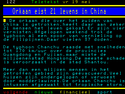
170 km/h maar?? Stelt ook niks voor
Doe mee met het voorspellen van het weer!
Weekvoorspelling | Week 12 (invullen tot 16-03 - 11:59)
Maandvoorspelling Maart (Inzendingen gesloten)
Jaarvoorspelling 2025 / 2026
Weekvoorspelling | Week 12 (invullen tot 16-03 - 11:59)
Maandvoorspelling Maart (Inzendingen gesloten)
Jaarvoorspelling 2025 / 2026

Eigenlijk best wel een onvoorstelbaar goed georganiseerde evacuatiemachine, daar in China. Een miljoen mensen geevacueerd. Dat zie ik de VS nog niet voor elkaar krijgen. Laat staan Nederland.quote:
Veel te eigenwijze inwoners.
Wie gelooft in God gelooft niet in al die andere 19.999 goden.
Ik geloof niet in 20.000 goden. Zo'n klein verschil maar zoveel discussie.
Ik geloof niet in 20.000 goden. Zo'n klein verschil maar zoveel discussie.
Wordt een actief seizoen voorspellen ze.
via hurricanetrack.com
via hurricanetrack.com
quote:UPDATED: 11:55 am EDT, May 22, 2006
NOAA CHIMES IN WITH THEIR PREDICTION FOR THE SEASON
The researchers at NOAA have announced their thoughts about the 2006 hurricane season and are calling for another "very active" season. The total number of named storms could be as high as 16 with as many as 10 hurricanes forming. Perhaps the more alarming number is the amount of intense, or category three and higher, hurricanes; NOAA is predicting four to six of those. It is the intense or major hurricanes that result in 80% of the damage that we see. Last year, four major hurricanes hit the United States- with Katrina being the worst. Dennis, Rita and Wilma were also major hurricanes and each of them left a legacy of destruction in their wakes.
NOAA is urging Americans to be ready for this season and has launced a National Hurricane Preparedness Week in other to facilitate that goal..
* I intend to live forever, so far so good! *
Hurricanes: Category 6 listing possible
MIAMI, May 22 (UPI) -- With some scientists saying global warming is causing an increasing frequency and strength of hurricanes, there is a call for a new category of storms.
In fact, ABC News says there have already been hurricanes strong enough to qualify as Category 6 -- having sustained winds of more than 175 or 180 mph.
The current scale defines storms with sustained winds between 74 and 95 mph as Category 1 hurricanes, Category 2 has sustained winds from 96 to 110 mph, Category 3 has sustained winds from 111 to 130 mph, Category 4 has sustained winds between 131 and 155 mph, and a Category 5 storm has sustained winds greater than 155 mph.
A Category 6 storm would have wind speeds greater than 175 or 180 mph.
U.S. government forecasters at the National Hurricane Forecast Center in Miami didn't well predict the 2005 Atlantic hurricane season, partly because of their unfamiliarity with global warming.
In May 2005, NOAA predicted the Atlantic would see 12 to 15 named tropical storms. There were 28. The experts forecast seven to nine storms would become hurricanes but 15 reached that level.
(Bron: United Press International)
Doe mee met het voorspellen van het weer!
Weekvoorspelling | Week 12 (invullen tot 16-03 - 11:59)
Maandvoorspelling Maart (Inzendingen gesloten)
Jaarvoorspelling 2025 / 2026
Weekvoorspelling | Week 12 (invullen tot 16-03 - 11:59)
Maandvoorspelling Maart (Inzendingen gesloten)
Jaarvoorspelling 2025 / 2026
Hallo, category 6? Pfff... die wil je niet meemaken volgens mij.
* I intend to live forever, so far so good! *
Cat. 5 wel dan?quote:Op dinsdag 23 mei 2006 14:56 schreef IkWilbert het volgende:
Hallo, category 6? Pfff... die wil je niet meemaken volgens mij.
You cannot discover new oceans unless
you have the courage to lose sight of
the shore
you have the courage to lose sight of
the shore
Waarom niet, kan lachen zijn!quote:Op dinsdag 23 mei 2006 14:56 schreef IkWilbert het volgende:
Hallo, category 6? Pfff... die wil je niet meemaken volgens mij.
Doe mee met het voorspellen van het weer!
Weekvoorspelling | Week 12 (invullen tot 16-03 - 11:59)
Maandvoorspelling Maart (Inzendingen gesloten)
Jaarvoorspelling 2025 / 2026
Weekvoorspelling | Week 12 (invullen tot 16-03 - 11:59)
Maandvoorspelling Maart (Inzendingen gesloten)
Jaarvoorspelling 2025 / 2026
Hurricane Wilma kwam/ komt in aanmerking. Als ik me niet vergis, hurricane Wilma was category 6.quote:Op dinsdag 23 mei 2006 14:56 schreef IkWilbert het volgende:
Hallo, category 6? Pfff... die wil je niet meemaken volgens mij.
Echter, categorie 6 bestond toen niet.
Misschien moeten we de vraag stellen, is categorie 7 mogelijk?
[ Bericht 15% gewijzigd door francorex op 23-05-2006 20:25:20 ]
Ja die is zeker mogelijk, let maar op, als europa de eerste orkanen gaat krijgen dan heb je in de VS al cat 7/8
Doe mee met het voorspellen van het weer!
Weekvoorspelling | Week 12 (invullen tot 16-03 - 11:59)
Maandvoorspelling Maart (Inzendingen gesloten)
Jaarvoorspelling 2025 / 2026
Weekvoorspelling | Week 12 (invullen tot 16-03 - 11:59)
Maandvoorspelling Maart (Inzendingen gesloten)
Jaarvoorspelling 2025 / 2026
alles is mogelijk. Je zou zelfs categorie 100 kunnen instellen, alleen zullen zulke orkanen niet voorkomen....
/ ¦ ¦ / ¦ ¦
op andere planeten zijn genoeg stormen die voor categorie 7 tot 10 in aanmerking komen... misschien kunnen we d'r eentje mee jattenquote:Op dinsdag 23 mei 2006 20:19 schreef francorex het volgende:
[..]
Hurricane Wilma kwam/ komt in aanmerking. Als ik me niet vergis, hurricane Wilma was category 6.
Echter, categorie 6 bestond toen niet.
Misschien moeten we de vraag stellen, is categorie 7 mogelijk?
Oh jawel hoor, op de planeet Jupiter bijvoorbeeldquote:Op dinsdag 23 mei 2006 20:28 schreef highway101 het volgende:alles is mogelijk. Je zou zelfs categorie 100 kunnen instellen, alleen zullen zulke orkanen niet voorkomen....
Ontopic: Dus wie bepaalt er nou of de zesde categorie officieel word, en wat de exacte specificatie wordt
Ik zou het niet weten maar ik weet wel dat er nu een CAT 6 gaat komen met CAT 5 als landfall....ze doen er niks voor niks een CAT erbij, hier zit echt wat achter
Doe mee met het voorspellen van het weer!
Weekvoorspelling | Week 12 (invullen tot 16-03 - 11:59)
Maandvoorspelling Maart (Inzendingen gesloten)
Jaarvoorspelling 2025 / 2026
Weekvoorspelling | Week 12 (invullen tot 16-03 - 11:59)
Maandvoorspelling Maart (Inzendingen gesloten)
Jaarvoorspelling 2025 / 2026
En we kunnen nu officieel melden dat het ' Amerikaanse ' Stormenseizoen nu echt is begonnen met de eerste storm van het seizoen: ALETTA is een feit.
Weliswaar zit deze storm aan de Pacifische kant van de VS, maar het is en blijft de eerste storm van het seizoen en dat al voor 1 juni...
MEXICO CITY — Aletta became the first tropical storm of the season in the eastern Pacific on Saturday when it formed about 100 miles south of the Mexican coastal resort of Acapulco.
Forecasters predicted it would head toward land but later change direction, skirt the coast and head out to sea.
Mexico issued a tropical storm watch for a 240-mile stretch of coast from Punta Maldonado to Zihuatanejo, the U.S. National Hurricane Center in Miami reported.
Tropical Storm Aletta had winds of about 40 mph and was expected to reach wind speeds as high as 60 mph. Forecasters were predicting heavy rainfall to the Mexican coast.
The storm was moving north at about 7 mph, but forecasters did not expect it to reach the coast before turning back out to sea.
Weliswaar zit deze storm aan de Pacifische kant van de VS, maar het is en blijft de eerste storm van het seizoen en dat al voor 1 juni...

MEXICO CITY — Aletta became the first tropical storm of the season in the eastern Pacific on Saturday when it formed about 100 miles south of the Mexican coastal resort of Acapulco.
Forecasters predicted it would head toward land but later change direction, skirt the coast and head out to sea.
Mexico issued a tropical storm watch for a 240-mile stretch of coast from Punta Maldonado to Zihuatanejo, the U.S. National Hurricane Center in Miami reported.
Tropical Storm Aletta had winds of about 40 mph and was expected to reach wind speeds as high as 60 mph. Forecasters were predicting heavy rainfall to the Mexican coast.
The storm was moving north at about 7 mph, but forecasters did not expect it to reach the coast before turning back out to sea.
Laat maar komen
Doe mee met het voorspellen van het weer!
Weekvoorspelling | Week 12 (invullen tot 16-03 - 11:59)
Maandvoorspelling Maart (Inzendingen gesloten)
Jaarvoorspelling 2025 / 2026
Weekvoorspelling | Week 12 (invullen tot 16-03 - 11:59)
Maandvoorspelling Maart (Inzendingen gesloten)
Jaarvoorspelling 2025 / 2026

Nee nog niet Over drie weken als ik weer terug ben in Nederland, dan mogen ze komen. NIET eerderquote:Op maandag 29 mei 2006 17:23 schreef SpeedyGJ het volgende:
Laat maar komen
LastFM
03/06 Maccabees - 10/06 Gaslight Anthem - 18/06 Oi Vai Voi - 20/06 Green Beats - 24/06 Ghinzu - 18/07 Extrema Outdoor
03/06 Maccabees - 10/06 Gaslight Anthem - 18/06 Oi Vai Voi - 20/06 Green Beats - 24/06 Ghinzu - 18/07 Extrema Outdoor
Wil je geen kleine orkaan mee maken dan?? max windsnelheden van kleine 150km/h is voldoende lijkt mij
Doe mee met het voorspellen van het weer!
Weekvoorspelling | Week 12 (invullen tot 16-03 - 11:59)
Maandvoorspelling Maart (Inzendingen gesloten)
Jaarvoorspelling 2025 / 2026
Weekvoorspelling | Week 12 (invullen tot 16-03 - 11:59)
Maandvoorspelling Maart (Inzendingen gesloten)
Jaarvoorspelling 2025 / 2026

Ik wil zon zee en bier En zo'n orkaan brengt meestal toch wel 1-2 dagen kutweer, hoge golven... En dat is niet leuk voor snorkelen, duiken, niks doen. Een orkaantje meemaken lijkt me op zich wel leuk ( ) maar die zooi erna en ervoor is een beetje zonde voor m'n verdiende vakantiequote:Op maandag 29 mei 2006 17:32 schreef SpeedyGJ het volgende:
Wil je geen kleine orkaan mee maken dan?? max windsnelheden van kleine 150km/h is voldoende lijkt mij
LastFM
03/06 Maccabees - 10/06 Gaslight Anthem - 18/06 Oi Vai Voi - 20/06 Green Beats - 24/06 Ghinzu - 18/07 Extrema Outdoor
03/06 Maccabees - 10/06 Gaslight Anthem - 18/06 Oi Vai Voi - 20/06 Green Beats - 24/06 Ghinzu - 18/07 Extrema Outdoor
Niet zeuren ik wil wel een cat 6 mee maken
Doe mee met het voorspellen van het weer!
Weekvoorspelling | Week 12 (invullen tot 16-03 - 11:59)
Maandvoorspelling Maart (Inzendingen gesloten)
Jaarvoorspelling 2025 / 2026
Weekvoorspelling | Week 12 (invullen tot 16-03 - 11:59)
Maandvoorspelling Maart (Inzendingen gesloten)
Jaarvoorspelling 2025 / 2026

Ja, geweldig, maar niet op vakantie.quote:Op maandag 29 mei 2006 17:38 schreef SpeedyGJ het volgende:
Niet zeuren ik wil wel een cat 6 mee maken
LastFM
03/06 Maccabees - 10/06 Gaslight Anthem - 18/06 Oi Vai Voi - 20/06 Green Beats - 24/06 Ghinzu - 18/07 Extrema Outdoor
03/06 Maccabees - 10/06 Gaslight Anthem - 18/06 Oi Vai Voi - 20/06 Green Beats - 24/06 Ghinzu - 18/07 Extrema Outdoor
jij hoort sinds 16-02-2006 een orkaan van 6e categorie mee te maken in bedquote:Op maandag 29 mei 2006 17:38 schreef SpeedyGJ het volgende:
Niet zeuren ik wil wel een cat 6 mee maken
Hier nog een opmerking die ik van Amerikaanse nieuwssites haalde
=
Zelfs de Amerikanen schenken ineens massale aandacht aan ons kleine landje na een opmerking over de zeespiegelstijging van ca 14 inch in 2050 (ca 35 cm)
=======================
THE HAGUE, Netherlands — The Dutch can expect wetter winters and a threatening rise in sea levels of up to 14 inches by 2050, said a report Tuesday by the National Weather Service.
While many countries discuss global warming and greenhouse gas emissions as theories, the Dutch see climate change as a matter of survival demanding concrete action.
"Sixty percent of our country lies beneath sea level, so the effect of a rise in the level of the oceans is very noticeable," said Melanie Schultz van Haegen, the secretary of transport and water, after receiving the report from the Royal Dutch Meteorological Institute known by its Dutch acronym KNMI.
But she said there was "no acute danger" to the country's sea defenses, which are among the best in the world.
The Dutch earmark more than $1.2 billion annually — around 1 percent of the national budget — to maintain and improve the dikes, dunes, pumps, sluices and windmills that work constantly to keep the country dry.
Those defenses must take into account the consequences of global warming, but Schultz van Haegen said it could be done within existing spending plans
KNMI put forward a range of scenarios it thought were strong enough to base policy on, using measurements and modeling by its own scientists as well as the most recent international studies.
It predicted an increase in average temperature in the Netherlands of at 1.8 degrees to 3.6 degrees by 2050, compared with 1990, and a rise in sea level by 6 inches to 14 inches.
"If you plan a children's birthday party in the Netherlands in July, you know it can be great weather, but you can also have a cloudburst. If you're prudent, you're prepared for both scenarios," said KNMI climate expert Gerbrand Komen, presenting the findings. "It can also snow in July, but you don't really need to plan for it," he said.
The report says rainfall will likely increase by 4-14 percent in the winter, and intense cloudbursts will become more common in the summer. But scientists cannot predict whether overall summer rain will decrease or increase, he said.
The history of the Netherlands, whose very name means "the low-lying countries," has been shaped by its struggle to cope with excess water, beginning before Roman times. The country's economic heart lies in the delta where the Rhine and Maas rivers meet the North Sea.
Since a 1953 flood that killed 1,800 people, sea defenses have been engineered to withstand any storm but the biggest predicted once every 10,000 years. River dikes are supposed to hold against a sustained rainfall statistically likely every 250 years.
By comparison, New Orleans' levies were designed against storms up to those likely to occur once in 100 years.
But even with global warming, the North Sea is not expected to generate storms the size or intensity of Hurricane Katrina.
Schultz van Haegen said she expected the European Union to agree on flood cooperation guidelines in July.
"Problems can't be pushed off on lower-lying countries, but each country must undertake a package of measures to take care of rain that falls in its borders," she said.
In April, the Dutch government said it expected to meet its Kyoto Protocol targets for reducing carbon dioxide emissions. Under the treaty, the Netherlands must cut greenhouse gas output 6 percent by 2012, from 1990 levels
doe dan 2007quote:Op maandag 29 mei 2006 19:42 schreef Frutsel het volgende:
[..]
jij hoort sinds 16-02-2006 een orkaan van 6e categorie mee te maken in bed
Doe mee met het voorspellen van het weer!
Weekvoorspelling | Week 12 (invullen tot 16-03 - 11:59)
Maandvoorspelling Maart (Inzendingen gesloten)
Jaarvoorspelling 2025 / 2026
Weekvoorspelling | Week 12 (invullen tot 16-03 - 11:59)
Maandvoorspelling Maart (Inzendingen gesloten)
Jaarvoorspelling 2025 / 2026
Study: Hurricanes go stronger due to Human Pollution
FORT COLLINS, Colo. — Kerry Emanuel sparked a debate among his colleagues last year when he published a paper that linked global warming to the trend of increasingly stronger Atlantic Ocean hurricanes observed in recent decades.
In a study to be published soon, the Massachusetts Institute of Technology climatologist will make another bold claim: The cycling of hurricane activity from high to low, which some scientists have attributed to a natural cycle in global weather patterns, is in fact caused by the rise and fall of pollution released by humans.
Furthermore, Emanuel, along with Michael Mann of Pennsylvania State University, contend that the microscopic aerosol particles, which reflect sunlight and cool the atmosphere, have been masking the effect of global warming on Atlantic Ocean hurricanes for several decades. The researchers say that it is only in recent decades, as aerosol emissions from North America and Europe have declined due to clean air standards, that the full impact of greenhouse gas emissions on hurricane strength has been realized.
Meanwhile, other new research by Purdue University scientists supports Emanuel’s original finding and extends it to the entire globe.
Together, the two new studies suggest that hurricanes, known as cyclones elsewhere, are getting stronger all over the planet and that humans play a role in the change
Stronger cyclones worldwide
Research done by Matthew Huber and Ryan Sriver at Purdue University in Indiana independently verifies and expands upon Emanuel’s 2005 study, which showed that hurricanes in the Atlantic and Pacific Oceans had increased in duration and intensity by about 50 percent since the 1970s. Emanuel linked the trend to rising sea surface temperatures, or SSTs, caused in part by global warming.
"We used a different technique and different data than Dr. Emanuel, who looked specifically at the Atlantic and western Pacific oceans, whereas we looked at the entire world," Huber said. "Nevertheless, we got the same results that he did, the same basic trends."
The researchers used surface wind and temperature records from the European Centre for Medium-Range Weather Forecasts 40 Year Reanalysis Project to estimate the total wind output of tropical cyclones worldwide from 1958 to 2001. Called the "globally integrated tropical cyclone power dissipation," this value represents the potential damage that a storm can cause.
The Purdue study marks the first time this value has been calculated on a global scale. It found that tropical cyclone activity has doubled over the past 40 years with only a quarter degree Celsius of tropical ocean warming. This is cause for concern, the researchers say, because scientists expect a two-degree warming over the course of the next century.
"The signal that we looked at is a measure of not only the intensity but also the duration of the storm," Sriver told LiveScience. "What we've seen is an increase in strength and duration but not necessarily in the number of storms."
feest, laat maar komen die zooi, en breng dan gelijk ons ook maar 1
Doe mee met het voorspellen van het weer!
Weekvoorspelling | Week 12 (invullen tot 16-03 - 11:59)
Maandvoorspelling Maart (Inzendingen gesloten)
Jaarvoorspelling 2025 / 2026
Weekvoorspelling | Week 12 (invullen tot 16-03 - 11:59)
Maandvoorspelling Maart (Inzendingen gesloten)
Jaarvoorspelling 2025 / 2026
The 2006 hurricane season begins today — Is everyone ready? click
Updated 6/1/2006 12:15 AM ET
Compleet overzicht, wat te verwachten in 2006, hurricane season 2006.
Merk op, de vele multi-media mogelijkheden in de rechter kolom.
Audio en video.
[ Bericht 1% gewijzigd door francorex op 02-06-2006 00:58:03 ]
Updated 6/1/2006 12:15 AM ET
Compleet overzicht, wat te verwachten in 2006, hurricane season 2006.
Merk op, de vele multi-media mogelijkheden in de rechter kolom.
Audio en video.
[ Bericht 1% gewijzigd door francorex op 02-06-2006 00:58:03 ]
En er zit weer een tropische depressie aan de pacifische kust van Mexico. Misschien dat Tropische Storm Bud zich daar als tweede van het seizoen ontwikkelt.
nog nie..maar wat nie is, kan nog komen...quote:Op zondag 4 juni 2006 19:27 schreef MajesticZ het volgende:
Ik ga 22 Juni naar Jamaica.. ben ik nou de sjaak?
Het gaat gebeuren!
bron: hurricanetrack.comquote:UPDATED: 8:45 am EDT, June 9, 2006
FIRST NAMED STORM ON THE WAY? IT'S POSSIBLE
The NHC is talking more about the possibility of tropical cyclone formation in or near the NW Caribbean Sea. We have a large area of showers and thunderstorms in the region and it has persisted for several days. Most of the global computer models develop this system and bring it northward in to the Gulf of Mexico. Whether or not this happens and how strong it will get are questions that cannot be answered right now. The good news is that it is only early June and environmental conditions are not conducive for a powerful hurricane to form out of this. Let's hope that remains the case- as we know, anything can happen. But the data right now indicates a slowly developing low pressure area that could become a tropical storm over time. Beyond that, we will just have to sit back and wait. I will post more here later this afternoon.
* I intend to live forever, so far so good! *
Nou...daar is ie dan ook op kaart...en tis er ook eentje die voor de OostKust van de VS voor wat overlast kan gaan zorgen... iets wat ze al voorspeld hadden... maar het schijnt nog te vroeg te zijn voor een 'monster' storm
[ Bericht 2% gewijzigd door Frutsel op 11-06-2006 20:42:56 ]

[ Bericht 2% gewijzigd door Frutsel op 11-06-2006 20:42:56 ]
http://www.wereldomroep.nl/news/international/#4913526quote:Tropische depressie op weg naar Florida
Boven het noordwesten van de Caribische Zee is de eerste tropische depressie van dit jaar tot ontwikkeling gekomen. Weerkundigen waarschuwen voor zware buien en overstromingen in delen van Cuba, de Kaaimaneilanden en het westen van Florida. De depressie ontwikkelt zich de komende uren mogelijk tot een tropische storm.
Vorig jaar werd het gebied geteisterd door hevige orkanen, die meer dan duizend levens eisten en voor grote schade zorgden. Ook voor 2006 is een zwaar orkaanseizoen voorspeld.
quote:Bron : NSNBC
First tropical depression of ’06 heads for Fla.
Weather system expected to be first named storm of hurricane season
The first tropical depression of the 2006 Atlantic hurricane system could make landfall near Florida.
MIAMI - A tropical depression in the Caribbean headed toward Florida on Saturday and was expected to become the first named storm of the 2006 Atlantic hurricane season.
The depression formed earlier in the day, nine days after the official start of the season, but the poorly organized system was not expected to become a hurricane, according to the National Hurricane Center.
“It will be relatively weak in terms of wind, but that doesn’t mean it’s going to be weak in terms of rainfall,” senior hurricane specialist Stacy Stewart said.
The system, which had maximum sustained wind near 35 mph, would be named Alberto if it reaches the 39 mph threshold for a tropical storm.
At 11 p.m. EDT, the depression was centered over the Eastern Gulf of Mexico about 290 miles west southwest of Key West, Fla., or about 440 miles south of Apalachicola, Fla., forecasters said. It was moving north-northwest near 9 mph.
The hurricane center recommended tropical storm warnings for the Cuban provinces of Pinar Del Rio and the Isle of Youth.
Over the next three days, the system is expected to move through the Yucatan Channel into the southeastern Gulf of Mexico, then toward Florida where it could make landfall Monday or Tuesday somewhere between South Florida and the western tip of the Panhandle, forecasters said.
The depression’s outer rainbands stretched Saturday to the southern tip of Florida, and heavy rain was forecast over the state’s Gulf Coast and the Florida Keys through Monday.
'The media overplays this'
State officials pleaded with residents to update their hurricane preparedness plans but most shrugged at the news.
“The media overplays this, they get people very scared,” said Tim Roberts, a Fort Lauderdale condo owner who was visiting Tallahassee. “Sure, when the time comes to be alarmed, yes, but don’t make more out of it until it’s time.”
Scientists predict the 2006 season could produce up to 16 named storms, six of them major hurricanes.
Last year’s hurricane season was the busiest and most destructive in recorded history. Hurricane Katrina alone devastated Louisiana and Mississippi and was blamed for more than 1,570 deaths in Louisiana alone.
Mike Martino lost his Navarre Beach home twice in the past two hurricane seasons — first to Hurricane Ivan in 2004, and never got to move into a new home built on the same lot because Hurricane Dennis wiped it out in 2005. Instead of rebuilding again, he moved to the mainland.
Martino, who rents kayaks, bikes and surfboards out of his store in Navarre Beach, worried that the weather would do more economic damage than property damage.
“I know that we have weather coming, so I can’t have weekly rentals, it’s all going to have to be done by the day,” he said.
Last year's season was busiest ever
The 2005 Atlantic hurricane season was the busiest in 154 years of storm tracking, with records set for the number of named storms (28) and hurricanes (15). Forecasters used up their list of 21 proper names (beginning with Arlene and ending with Wilma) and had to use the Greek alphabet to name storms for the first time.
Meteorologists have said the Atlantic is not as warm as it was at this time in 2005, meaning potential storms would have less of the energy needed to develop into hurricanes.
Atlantic hurricane seasons were relatively mild from the 1970s through 1994. Since then, all but two years have been above normal. Experts say the ocean is in the midst of a 20-year-cycle that will continue to bring strong storms.
From 1995 to 2005, the Atlantic season averaged 15 named storms, just over eight named hurricanes and four major hurricanes, according to the hurricane center. From 1971 to 1994, there were an average of 8.5 named storms, five hurricanes and just over one major hurricane. The Atlantic hurricane season ends Nov. 30.
© 2006 The Associated Press. All rights reserved. This material may not be published, broadcast, rewritten or redistributed.

Alberto heeft de westkust van Cuba al geteisterd met hevige regen. Op sommige plaatsen is meer dan 50 centimeter neerslag gevallen. Rond het oog worden windsnelheden waargenomen van ruim 75 kilometer per uur. De storm verplaatst zich met een snelheid van 15 kilometer per uur richting de Amerikaanse kust.
bron: nu.nl
bron: nu.nl
Alberto Strengthens Up
TAMPA, Florida (AP) -- The first named storm of the 2006 Atlantic hurricane season slightly strengthened early Monday in the Gulf of Mexico, prompting forecasters to issue tropical storm warnings for Florida's west coast.
Tropical Storm Alberto had maximum sustained wind near 50 mph but was not likely to grow into a hurricane, the National Hurricane Center said. There were no major reports of damage.
At 5 a.m. EDT, Alberto was centered about 275 miles south-southwest of Apalachicola. It was moving north-northeast at about 8 mph and could make landfall Tuesday night, forecasters said.


Kom maar bezoekje Nederland brengen
Doe mee met het voorspellen van het weer!
Weekvoorspelling | Week 12 (invullen tot 16-03 - 11:59)
Maandvoorspelling Maart (Inzendingen gesloten)
Jaarvoorspelling 2025 / 2026
Weekvoorspelling | Week 12 (invullen tot 16-03 - 11:59)
Maandvoorspelling Maart (Inzendingen gesloten)
Jaarvoorspelling 2025 / 2026
Mooi zo, laat maar komen
Doe mee met het voorspellen van het weer!
Weekvoorspelling | Week 12 (invullen tot 16-03 - 11:59)
Maandvoorspelling Maart (Inzendingen gesloten)
Jaarvoorspelling 2025 / 2026
Weekvoorspelling | Week 12 (invullen tot 16-03 - 11:59)
Maandvoorspelling Maart (Inzendingen gesloten)
Jaarvoorspelling 2025 / 2026

Kun je niet beter een topic in ONZ openen?quote:Op maandag 12 juni 2006 16:40 schreef SpeedyGJ het volgende:
Kom maar bezoekje Nederland brengen
MIAMI - De tropische storm Alberto heeft maandag definitief koers gezet naar de westkust van de Amerikaanse staat Florida. De autoriteiten hebben een officieel weeralarm afgegeven, aldus Amerikaanse media.
bron nu.nl

bron nu.nl
Het zal niet veel schelen.quote:Op maandag 12 juni 2006 22:35 schreef highway101 het volgende:
70mph is toch bijna orkaankracht?
Categorie 1: windsnelheden tussen 118 en 152 kilometer per uur.
70 mph is 110 kilometer per uur
Alberto zal overigens geen orkaan worden, de autoriteiten in Florida hebben de orkaanwaarschuwing ingetrokken

Inmiddels is Jelaway alweer uitgeraast en komt EWINIAR de hoek om kijken.
En dit wordt er eentje van de zwaarste categorie zo te zien. Gelukkig is er niet direct land in de omgeving...
En dit wordt er eentje van de zwaarste categorie zo te zien. Gelukkig is er niet direct land in de omgeving...

wel jammer dat we hier altijd van dat saaie standaard weer hebben.. het meest extreme dat we hier krijgen is een regenbui met 1x in de 5 min een beetje onweer
West Europa heeft behoorlijk onvoorspelbaar weer hoor. Ik kan beter voorspellen wat voor weer het op 3 oktober in San Francisco (graad of 17, bewolkt) is dan over 2 weken in Nederland. Alles tussen (zeg) de 12 en 32 graden is mogelijk. Erg afwisselend, maar inderdaad weinig (globale) extremen. Vind ik wel OK.
dat afwisselende doe je het ook niet voor.. elke 3 dagen zon die we krijgen, volgen met 3 weken regen.. geef mij dan maar 3 maanden zon, en 3 maanden regen lekker stabiel weer, je kan tenminste gewoon normaal afspreken om van het weekend naar het strand te gaan, ipv dat je tot vrijdag avond moet wachten tot je met enige zekerheid kan zeggen of het slim is om te gaan of niet
Hmm...volgens deze foto is typhoon Ewiniar al een heel eind japan genaderd, terwijl
(plaatje komt van --> http://visibleearth.nasa.gov/view_rec.php?id=693
(plaatje komt van --> http://visibleearth.nasa.gov/view_rec.php?id=693

Terwijl het hier lijkt dat het veel verder zuidelijk is...quote:This is the SeaWiFS view of Typhoon Ewiniar to the south of Japan earlier today. The remnants of Jelawat can still be seen over eastern China in the upper left corner of the image.
Dat kruisje is de verwachtte positie op 7 juli middernacht (GMT). Het groene pijlpuntje was de positie op 2 juli middernacht GMT, dus nu zo'n 13 uur geleden. En dat verschil is wel erg groot.
ik zat te denken dat het misschien een satelietfoto is van een storm die dezelfde naam had... (van jaren terug?) maar omdat die ene tekst er bij staat
en dat dus van die andere storm ook klopt, twijfel ik...
quote:This is the SeaWiFS view of Typhoon Ewiniar to the south of Japan earlier today. The remnants of Jelawat can still be seen over eastern China in the upper left corner of the image.
en dat dus van die andere storm ook klopt, twijfel ik...
Zoals je op bovenstaand plaatje kan zien lijkt het er opdat het zuidelijke deel van Japan toch nog een aardig stormpje gaat krijgen, vooral de kleinere eilanden onder Japan zullen een aardige orkaan kunnen verwachten

Volgens HurricaneTrack
There is only one area of interest in the Atlantic that truly catches my attention but even it will likely not amount to much. A strong tropical wave is making its way across the deep tropics near 10N and 45 W. Deep thunderstorms have popped up as of late but the overall environment for additional development does not look favorable. Once again, none of the major global computer models indicate strong chances for development. It is still very early in the season and I think we will continue to see a quiet pattern in the tropics for many more days to come. Last year was an incredible anomaly. I believe we will see a year like 2004 where a bulk of the development takes place in August and September- which is climatologically the most active months anyway. So- good news for now- it appears the week ahead will see little in the way of trouble from the tropics.
There is only one area of interest in the Atlantic that truly catches my attention but even it will likely not amount to much. A strong tropical wave is making its way across the deep tropics near 10N and 45 W. Deep thunderstorms have popped up as of late but the overall environment for additional development does not look favorable. Once again, none of the major global computer models indicate strong chances for development. It is still very early in the season and I think we will continue to see a quiet pattern in the tropics for many more days to come. Last year was an incredible anomaly. I believe we will see a year like 2004 where a bulk of the development takes place in August and September- which is climatologically the most active months anyway. So- good news for now- it appears the week ahead will see little in the way of trouble from the tropics.
vorig jaar om deze tijd waren er al 4 tropischs stormen geweest in de noord-atlantische regio.
komt wat later op gang maar drukste maanden zijn augustus/september.
dan is het water waar ze ontstaan goed warm en minder verschil in windsnelheid op verschillende hoogten.
komt wat later op gang maar drukste maanden zijn augustus/september.
dan is het water waar ze ontstaan goed warm en minder verschil in windsnelheid op verschillende hoogten.
Dostojewski: "Je kunt je niet van je eigen gezond verstand overtuigen door je buurman op te sluiten."
Tropical Storm Bilis heads for Taiwan
'
Taipei, July 9 (CNA) Another tropical storm, Bilis, was reported Sunday to be moving northwest across the Philippine Sea toward Taiwan, just after the Central Weather Bureau (CWB) lifted a sea warning for Typhoon Ewiniar earlier that day.
According to a CWB forecast, Bilis was located at latitude 13 degrees 8 minutes north and longitude 135 degrees 0 minutes east at 2 p.m. -- about 840 kilometers off Guam.
The storm's 100-km radius, with center winds of 18 meters per second and gusts up to 25 meters per second, was moving northwest toward Taiwan at 22 km per hour. It is expected to change direction slightly by moving west-northwest.
The CWB pedicted that Bilis could affect Taiwan's weather from July 14 to 17.
Bilis, the fourth tropical storm of this year, came on the heels of Typhoon Ewiniar, which swept across the seas east of Taiwan and brought heavy rain to southern Taiwan.
The CWB warned that residents in central and southern Taiwan should guard against heavy or torrential rain brought by Typhoon Ewiniar.
The CWB said residents of mountainous areas in Chiayi, Tainan and Kaohsiung counties should take precautions against falling rocks, landslides, mudflows, swollen creeks and flash floods in the next two days.
======
En ook voor de Westkust van de VS heeft zich een Tropische Depressie gevormd, die tot op dit moment geen land bedreigt en/of zwaar lijkt te worden.
En inmiddels hebben we Hurricane Bud en Tropical Storm Carlotta aan de Westkust van de VSquote:Op dinsdag 11 juli 2006 09:29 schreef Frutsel het volgende:
En ook voor de Westkust van de VS heeft zich een Tropische Depressie gevormd, die tot op dit moment geen land bedreigt en/of zwaar lijkt te worden.
BUD

CARLOTTA

De Atlantic blijft rustig vooralsnog...
oké .. ik geef t toe.. dit is een schaamteloze tvp..
Maar ik wil het, als ik straks tijd heb eens allemaal bekijken...ik vind het boeiend.. helemaal over het hoofd gezien..
Maar ik wil het, als ik straks tijd heb eens allemaal bekijken...ik vind het boeiend.. helemaal over het hoofd gezien..
Love can move you..take you deeper everytime
Love can move you..to a place inside your heart
Love can move you..to a place inside your heart
Welkomquote:Op maandag 17 juli 2006 15:04 schreef _Cara_ het volgende:
oké .. ik geef t toe.. dit is een schaamteloze tvp..
Maar ik wil het, als ik straks tijd heb eens allemaal bekijken...ik vind het boeiend.. helemaal over het hoofd gezien..
115 doden door Orkaan Bilis
Afgelopen weekend zijn minstens 178 doden gevallen en worden meer dan 100 mensen nog vermist. Door de harde wind en zware regenval staan grote delen onder water. Wegen zijn weggespoeld, het treinverkeer is op veel plaatsen ontregeld en er zijn ook veel energiekabels geknapt.
Evacuaties
De storm heeft ook al tienduizenden huizen weggevaagd. De Chinese regering had veel mensen uit de streek laten evacueren, maar ondanks dat zijn er toch veel slachtoffers gevallen.
Zuid-Korea
In Zuid-Korea zijn al 41 doden en vermisten als gevolg van de hevige mossoenregens van de afgelopen drie dagen. De hevige regenval veroorzaakte aardverschuivingen en overstromingen. Meer dan 2400 mensen zijn dakloos geraakt als gevolg van het noodweer.
====
Tyfoon Bilis heeft nog aardig huisgehouden in Zuid Oost Azie zo te lezen en dat terwijl de kracht toch al aardig was afgenomen dacht ik. Zo zie je maar weer dat Moedertje Natuur niet te temmen is
Tropical Depression TWO
wordt Tropische Storm Beryl?

wordt Tropische Storm Beryl?
Dostojewski: "Je kunt je niet van je eigen gezond verstand overtuigen door je buurman op te sluiten."

Hurricane Daniel
Dostojewski: "Je kunt je niet van je eigen gezond verstand overtuigen door je buurman op te sluiten."
Oe begint wat leven in te komen
Doe mee met het voorspellen van het weer!
Weekvoorspelling | Week 12 (invullen tot 16-03 - 11:59)
Maandvoorspelling Maart (Inzendingen gesloten)
Jaarvoorspelling 2025 / 2026
Weekvoorspelling | Week 12 (invullen tot 16-03 - 11:59)
Maandvoorspelling Maart (Inzendingen gesloten)
Jaarvoorspelling 2025 / 2026
De hittegolven van de laatste tijd zorgen er natuurlijk ook voor dat het water wat warmer wordt, misschien warm genoeg om hier ook eens een orkaan te krijgen...
Ach een CAT 1 zou een super afsluiter zijn voor deze hittegolf, en misschien ook wel voor deze zomerquote:Op dinsdag 18 juli 2006 22:49 schreef Light het volgende:
De hittegolven van de laatste tijd zorgen er natuurlijk ook voor dat het water wat warmer wordt, misschien warm genoeg om hier ook eens een orkaan te krijgen...
Doe mee met het voorspellen van het weer!
Weekvoorspelling | Week 12 (invullen tot 16-03 - 11:59)
Maandvoorspelling Maart (Inzendingen gesloten)
Jaarvoorspelling 2025 / 2026
Weekvoorspelling | Week 12 (invullen tot 16-03 - 11:59)
Maandvoorspelling Maart (Inzendingen gesloten)
Jaarvoorspelling 2025 / 2026
Een CAT 1 kan hier al voor heel wat schade zorgen, helemaal omdat men hier niet op zoiets is ingesteld.
denk niet dat we d at meemaken in ons leventje Speedyquote:Op dinsdag 18 juli 2006 22:52 schreef SpeedyGJ het volgende:
[..]
Ach een CAT 1 zou een super afsluiter zijn voor deze hittegolf, en misschien ook wel voor deze zomer
HET MOET GEWOON THIS VERPLICHT!
Wil nu stormen hebben
Wil nu stormen hebben
Doe mee met het voorspellen van het weer!
Weekvoorspelling | Week 12 (invullen tot 16-03 - 11:59)
Maandvoorspelling Maart (Inzendingen gesloten)
Jaarvoorspelling 2025 / 2026
Weekvoorspelling | Week 12 (invullen tot 16-03 - 11:59)
Maandvoorspelling Maart (Inzendingen gesloten)
Jaarvoorspelling 2025 / 2026
Ik heb het idee dat orkanen alleen aan de westkant van de atlantische oceaan voorkomen, dus dan zitten we hier wel veilig.quote:Op dinsdag 18 juli 2006 22:56 schreef Frutsel het volgende:
[..]
denk niet dat we d at meemaken in ons leventje Speedy
En tis nu officieel Beryl
=================
MIAMI, Florida (AP) -- The second tropical storm of the 2006 Atlantic hurricane season formed off the North Carolina coast Tuesday, and a tropical storm watch was issued for the eastern part of the state.
Meteorologists estimated Tropical Storm Beryl's maximum sustained winds at 40 mph. The storm was upgraded from a tropical depression Tuesday afternoon.
At 5 p.m. ET (2100 GMT), the storm was centered about 180 miles (290 kilometers) southeast of Cape Hatteras and was moving toward the north at nearly 6 mph (9 kph), the National Hurricane Center said. A slow turn toward the north-northwest was expected later Tuesday or Wednesday.
A hurricane hunter aircraft was sent into the storm Tuesday to acquire detailed information for forecasters, hurricane specialist Jamie Rhome said.
However, early indications were that the system's sustained wind wouldn't reach 74 mph, the threshold for a hurricane.
"We're certainly not expecting anything major, a major hurricane or anything like that," Rhome said.
The early forecast track indicated that the system could drift toward the west and be near the North Carolina coast by the middle or later part of the week, Rhome said.
The tropical storm watch, indicating tropical storm conditions are possible within 36 hours, extended along the coast from north of Cape Lookout to south of Currituck Beach Light.
The first named storm of the June-November Atlantic hurricane season, Tropical Storm Alberto, splashed ashore in Florida in mid-June, then plowed northward along the coast past North Carolina's Outer Banks. It was blamed for one drowning.
Experts say the Atlantic Ocean is in the middle of a cycle of increased hurricane activity. Last year, there were a record 28 named storms and 15 hurricanes, including destructive Katrina.

vorig jaar kwam ze toch met dit soort kaartjes op de site van National Hurricane Center.
nu zie ik die niet meer.
Dostojewski: "Je kunt je niet van je eigen gezond verstand overtuigen door je buurman op te sluiten."

Seizoen val wel mee tot nu toch? Of was dat vorig jaar ook zo?
LastFM
03/06 Maccabees - 10/06 Gaslight Anthem - 18/06 Oi Vai Voi - 20/06 Green Beats - 24/06 Ghinzu - 18/07 Extrema Outdoor
03/06 Maccabees - 10/06 Gaslight Anthem - 18/06 Oi Vai Voi - 20/06 Green Beats - 24/06 Ghinzu - 18/07 Extrema Outdoor
Neeeeheeee, vorig jaar begon het al heel vroeg, het is idd opmerkelijk rustig, toch is het water warmer dan vorigjaar, vreemd
Doe mee met het voorspellen van het weer!
Weekvoorspelling | Week 12 (invullen tot 16-03 - 11:59)
Maandvoorspelling Maart (Inzendingen gesloten)
Jaarvoorspelling 2025 / 2026
Weekvoorspelling | Week 12 (invullen tot 16-03 - 11:59)
Maandvoorspelling Maart (Inzendingen gesloten)
Jaarvoorspelling 2025 / 2026
Inderdaad, volgens mij hadden 'we' er vorig jaar al een stuk of vjif gehad nu?
[b]Op maandag 6 september 2010 00:28 schreef tong80 het volgende:[/b]
GVD Wat moet jij een trotse vader zijn :)
:P
GVD Wat moet jij een trotse vader zijn :)
:P
Kaemi Steekt de kop op en koerst richting Taiwan en het vorige week getroffen gebied in China door Orkaan Bilis. Echter lijkt Kaemi niet zo heel sterk te worden

jep, vijf om precies te zijn, waaronder Dennis en Emily die voor nogal wat schade en overlast hebben gezorgd. Juli was rustig voorspeld... 2 depressies/stormen in de tweede helft van maand. Beryl is daarvan de eerstequote:Op woensdag 19 juli 2006 07:37 schreef Againzender het volgende:
Inderdaad, volgens mij hadden 'we' er vorig jaar al een stuk of vjif gehad nu?
Speedy, er komt zo, als het goed is nog een radarkaart in de OP bij. Kan je de OP weer backuppen zodat ie actueel is als we straks aan deel 2 beginnen?quote:Op woensdag 19 juli 2006 07:00 schreef SpeedyGJ het volgende:
Neeeeheeee, vorig jaar begon het al heel vroeg, het is idd opmerkelijk rustig, toch is het water warmer dan vorigjaar, vreemd
OP geupdatequote:Op woensdag 19 juli 2006 12:07 schreef Frutsel het volgende:
[..]
Speedy, er komt zo, als het goed is nog een radarkaart in de OP bij. Kan je de OP weer backuppen zodat ie actueel is als we straks aan deel 2 beginnen?
Doe mee met het voorspellen van het weer!
Weekvoorspelling | Week 12 (invullen tot 16-03 - 11:59)
Maandvoorspelling Maart (Inzendingen gesloten)
Jaarvoorspelling 2025 / 2026
Weekvoorspelling | Week 12 (invullen tot 16-03 - 11:59)
Maandvoorspelling Maart (Inzendingen gesloten)
Jaarvoorspelling 2025 / 2026
Kaemi kon wel eens een zeer krachtige en gevaarljke storm gaan worden. Taiwan en Zuid Oost China kunnen de borst natmaken vanaf zondag...

Tropical Storm Beryl
BOSTON — Tropical Storm Beryl made landfall on Nantucket early Friday, bringing a steady, driving rain to coastal Massachusetts.
The storm's center hit around 3 a.m., said Jack Beven, hurricane specialist with the National Hurricane Center in Miami.
The wind and rain started to pick up just after midnight, said Rocky Fox, owner of the Chicken Box bar there. But he wasn't scared: "It's the kind that puddles quick," he said. "To us it's just a big old Nor'easter."Officials said the region was faring well. The Coast Guard said they hadn't heard of problems, and no power outages were reported.
Forecasters extended a tropical storm warning extended from Plymouth south and west to Woods Hole, including Cape Cod, Nantucket and Martha's Vineyard, according to the National Hurricane Center in Miami. Forecasters said the storm may bring in tides of 1 to 3 feet above normal.
"You don't go outside and watch the winds. You don't go and watch the waves," said Eric Blake, a hurricane specialist at the National Hurricane Center.
Hurricane Daniel
Hij 'leeft' al een tijdje (16 juli) en is ook vrij sterk geweest en het ziet er nu ook naar uit dat Hawai er nog wat van gaat meekrijgen. In welke kracht is nog onduidelijkheid over.
En tropische Storm Emilia heeft zich ook voor de Westkust van de VS gevormd, terwijl het Atlantische Basin verdacht rustig is.

Het lijkt er op dat het nu echt kan gaan beginnen
==========================================
We are starting to see signs that the Atlantic will become more active as well. A series of strong tropical waves are moving across the Basin but most are surrounded by dry, relatively stable air. This pattern will persist for another week or so and then should change some and allow for these potent pieces of energy to develop more. In fact, several runs of the operational GFS model suggest that August has the potential for starting off rather busy This is to be expected and there is absolutely nothing out there to worry about right now. Just be aware that we are about to enter the typical active period of the hurricane season. If you have been putting off those preparations for your home or business, get them done now. We need to be ready for what could be coming in the next few weeks.
hmmm, ziet er nog verdacht rustig uit nu,maar de spanning stijgt.quote:Op donderdag 27 juli 2006 12:01 schreef Frutsel het volgende:
Het lijkt er op dat het nu echt kan gaan beginnen
==========================================
quote:000
ABNT20 KNHC 291510
TWOAT
TROPICAL WEATHER OUTLOOK
NWS TPC/NATIONAL HURRICANE CENTER MIAMI FL
1130 AM EDT SAT JUL 29 2006
FOR THE NORTH ATLANTIC...CARIBBEAN SEA AND THE GULF OF MEXICO...
A LOW PRESSURE AREA...ASSOCIATED WITH A TROPICAL WAVE...IS LOCATED
ABOUT 1000 MILES EAST-SOUTHEAST OF THE SOUTHERN WINDWARD ISLANDS.
WHILE THE ASSOCIATED SHOWER ACTIVITY HAS DECREASED THIS MORNING...
THERE IS STILL POTENTIAL FOR DEVELOPMENT...AND A TROPICAL
DEPRESSION COULD FORM DURING THE NEXT DAY OR TWO AS THE SYSTEM
MOVES WESTWARD AT ABOUT 20 MPH.
SHOWER ACTIVITY HAS INCREASED THIS MORNING IN ASSOCIATION WITH A
WESTWARD MOVING TROPICAL WAVE OVER THE CENTRAL CARIBBEAN SEA.
HOWEVER...THERE ARE NO SIGNS OF ORGANIZATION...AND ADDITIONAL
DEVELOPMENT...IF ANY...SHOULD BE SLOW TO OCCUR.
ELSEWHERE...TROPICAL STORM FORMATION IS NOT EXPECTED THROUGH
SUNDAY.
$$
FORECASTER BEVEN
Super actie!!!!!!!!!!!!!!!!!! http://images.google.nl/images?q=Pantsil+israel+flag
Inderdaad eindigt juli toch rustig en begint augustus ook stil... ( )
The tropics are still quiet with no real threats of development anytime soon. There are a couple of areas to watch in the Atlantic but none of the global computer models suggest significant development over the next few days. There are some hints now from a couple of the models that we could see something move off of Africa and develop later this coming week. With July coming to a close, it won't be long now until we see conditions become quite favorable for tropical storm formation. We could also see some additional development in the east Pacific where things have been quite active lately- but this is likely a day or two away. I will post more here tomorrow.
=====================
Voor diegenen die een kalender willen
Voor 21,95$ heb je een 'recordyear poster'
The tropics are still quiet with no real threats of development anytime soon. There are a couple of areas to watch in the Atlantic but none of the global computer models suggest significant development over the next few days. There are some hints now from a couple of the models that we could see something move off of Africa and develop later this coming week. With July coming to a close, it won't be long now until we see conditions become quite favorable for tropical storm formation. We could also see some additional development in the east Pacific where things have been quite active lately- but this is likely a day or two away. I will post more here tomorrow.
=====================
Voor diegenen die een kalender willen

Voor 21,95$ heb je een 'recordyear poster'
New Tropical Depression in the Atlantic
As if right on cue, we have a new tropical depression in the Atlantic. However, it might not last too long as the environment around it is not very favorable for continued growth. The NHC upgraded the strong tropical wave to a depression tonight. The forecaster notes that strong shearing winds and dry air surrounding the tropical cyclone could cause it to make a quick fade to black. This would certainly be good news for people living along the forecast track. That track takes the depression over some of the islands of the NE Caribbean Sea and towards the SE Bahamas. Whether or not we still have something to track later in the week remains to be seen. As I have mentioned here in earlier posts, the global computer models really don't seem too enthusiastic about development with this system and so it could be that it will indeed be short-lived. In any case, we will certainly keep an eye on it and I will post regular updates here as conditions change.
MIAMI, Florida (AP) -- Tropical Storm Chris, the third named storm of the 2006 Atlantic hurricane season, developed early Tuesday near the Leeward Islands, forecasters at the National Hurricane Center said.
A tropical storm warning was posted for the islands of Antigua, Barbuda, Anguilla, St. Kitts, Nevis, Saba, St. Eustatius, St. Barthelemy and St. Martin.
A tropical storm watch was issued for Puerto Rico, the U.S. Virgin Islands and the British Virgin Islands.
At 5 a.m., Chris was centered about 175 miles east of Antigua and was moving west-northwest near 9 mph, forecasters said. Its maximum sustained winds were near 40 mph, just above the threshold for a tropical storm, according to the National Hurricane Center.
The storm was on track to pass over or near the northernmost Leeward Islands by early Wednesday, according to the hurricane center. The area where the warning was issued was in the open Atlantic about 1,100 miles southeast of Miami.
The first named storm of the 2006 season, Tropical Storm Alberto, swept over Florida in mid-June, then plowed northward along the coast past the Outer Banks. It was blamed for one drowning.
Massachusetts was spared the worst of Tropical Storm Beryl at the end of June when the storm left high surfs but minimal damage before heading toward Nova Scotia. The bulk of the rain fell over the ocean well east of the island.
[ Bericht 19% gewijzigd door Frutsel op 01-08-2006 13:06:20 ]
As if right on cue, we have a new tropical depression in the Atlantic. However, it might not last too long as the environment around it is not very favorable for continued growth. The NHC upgraded the strong tropical wave to a depression tonight. The forecaster notes that strong shearing winds and dry air surrounding the tropical cyclone could cause it to make a quick fade to black. This would certainly be good news for people living along the forecast track. That track takes the depression over some of the islands of the NE Caribbean Sea and towards the SE Bahamas. Whether or not we still have something to track later in the week remains to be seen. As I have mentioned here in earlier posts, the global computer models really don't seem too enthusiastic about development with this system and so it could be that it will indeed be short-lived. In any case, we will certainly keep an eye on it and I will post regular updates here as conditions change.

MIAMI, Florida (AP) -- Tropical Storm Chris, the third named storm of the 2006 Atlantic hurricane season, developed early Tuesday near the Leeward Islands, forecasters at the National Hurricane Center said.
A tropical storm warning was posted for the islands of Antigua, Barbuda, Anguilla, St. Kitts, Nevis, Saba, St. Eustatius, St. Barthelemy and St. Martin.
A tropical storm watch was issued for Puerto Rico, the U.S. Virgin Islands and the British Virgin Islands.
At 5 a.m., Chris was centered about 175 miles east of Antigua and was moving west-northwest near 9 mph, forecasters said. Its maximum sustained winds were near 40 mph, just above the threshold for a tropical storm, according to the National Hurricane Center.
The storm was on track to pass over or near the northernmost Leeward Islands by early Wednesday, according to the hurricane center. The area where the warning was issued was in the open Atlantic about 1,100 miles southeast of Miami.
The first named storm of the 2006 season, Tropical Storm Alberto, swept over Florida in mid-June, then plowed northward along the coast past the Outer Banks. It was blamed for one drowning.
Massachusetts was spared the worst of Tropical Storm Beryl at the end of June when the storm left high surfs but minimal damage before heading toward Nova Scotia. The bulk of the rain fell over the ocean well east of the island.
[ Bericht 19% gewijzigd door Frutsel op 01-08-2006 13:06:20 ]
Waarschijnlijk wordt hij vandaag of morgenvroeg geupgrade naar Hurricanequote:Op dinsdag 1 augustus 2006 11:58 schreef highway101 het volgende:
Tropical Storm Chris is ontstaan
Chris komt dus hoogstwaarschijnlijk aan land ergens aan de Gulf Coast halverwege volgende week.
Vraag is alleen waar. Zou de genadeslag voor New Orleans kunnen zijn.
Veel ligt nog in puin daar.
Vraag is alleen waar. Zou de genadeslag voor New Orleans kunnen zijn.
Veel ligt nog in puin daar.

Deze pagina ververst zichzelf. Bij het schrijven van deze post is het nog een TS vlakbij de S-eilanden.
/ ¦ ¦ / ¦ ¦
Hou deze ook in de gaten.... Typhoon Prapiroon
SHANGHAI, China — Typhoon Prapiroon roared toward southern China on Thursday packing winds of up to 80 mph, as authorities canceled train and ferry services and evacuated tens of thousands of people amid warnings of severe destruction.
At noon Thursday, the storm was centered 180 miles southeast of Hong Kong, and had turned northwest toward southern China's Guangzhou province at about 9 miles per hour, according to the Hong Kong Observatory.
Already blamed for six deaths in the Philippines, Prapiroon was expected to make landfall late Thursday or early Friday. Authorities evacuated 65,000 people from parts of Guangdong and the neighboring island province of Hainan, and ferry and railway services linking the two have been suspended.
About 53,200 boats had returned into ports on Hainan, which lies about 370 miles southwest of Hong Kong, and had been ordered recalled from Guangdong, official media reported. Rescue teams throughout the area have been ordered on alert for floods and landslides.
Prapiroon is "as strong, if not stronger" than an earlier storm, Bilis, which sparked floods and landslides that killed more than 600 people in southern China last month, Gao Shuanzhu, a senior official at the China's national observatory was quoted as saying by the official Xinhua News Agency on Wednesday.
===================
De tyfoon Prapiroon heeft de kust van China bereikt. Volgens de regering in Peking zijn er al 24 mensen om het leven gekomen. Gevreesd wordt dat dit aantal flink gaat stijgen
Zeker 65.000 Chinezen zijn uit vrees voor de tyfoon Prapiroon naar veiliger oorden gevlucht. Zeker 53.000 vissersboten voor de Zuid-Chinese kust zijn teruggeroepen naar de haven.
Zesde Tyfoon
Vooral de provincies Hainan, Guangdong, Guizhou en Guangxi worden zwaar getroffen door de harde wind en de grote regenval. Het is de zesde tyfoon die China dit seizoen treft.
[ Bericht 44% gewijzigd door Frutsel op 03-08-2006 22:01:45 ]

SHANGHAI, China — Typhoon Prapiroon roared toward southern China on Thursday packing winds of up to 80 mph, as authorities canceled train and ferry services and evacuated tens of thousands of people amid warnings of severe destruction.
At noon Thursday, the storm was centered 180 miles southeast of Hong Kong, and had turned northwest toward southern China's Guangzhou province at about 9 miles per hour, according to the Hong Kong Observatory.
Already blamed for six deaths in the Philippines, Prapiroon was expected to make landfall late Thursday or early Friday. Authorities evacuated 65,000 people from parts of Guangdong and the neighboring island province of Hainan, and ferry and railway services linking the two have been suspended.
About 53,200 boats had returned into ports on Hainan, which lies about 370 miles southwest of Hong Kong, and had been ordered recalled from Guangdong, official media reported. Rescue teams throughout the area have been ordered on alert for floods and landslides.
Prapiroon is "as strong, if not stronger" than an earlier storm, Bilis, which sparked floods and landslides that killed more than 600 people in southern China last month, Gao Shuanzhu, a senior official at the China's national observatory was quoted as saying by the official Xinhua News Agency on Wednesday.
===================
De tyfoon Prapiroon heeft de kust van China bereikt. Volgens de regering in Peking zijn er al 24 mensen om het leven gekomen. Gevreesd wordt dat dit aantal flink gaat stijgen
Zeker 65.000 Chinezen zijn uit vrees voor de tyfoon Prapiroon naar veiliger oorden gevlucht. Zeker 53.000 vissersboten voor de Zuid-Chinese kust zijn teruggeroepen naar de haven.
Zesde Tyfoon
Vooral de provincies Hainan, Guangdong, Guizhou en Guangxi worden zwaar getroffen door de harde wind en de grote regenval. Het is de zesde tyfoon die China dit seizoen treft.

[ Bericht 44% gewijzigd door Frutsel op 03-08-2006 22:01:45 ]

Zou het in Nederland mogelijk zijn, dat wij ook orkaanachtige dagen gaan meemaken, agv het (zeer) warme Noordzee water?
/ ¦ ¦ / ¦ ¦
Ik zeg niet graag nooit, maar toch: Nee. De Coriolis kracht tgv de draaiing van de aarde is in principe te groot op deze hoogte

En de komende dagen lijkt ook DEBBY haar opwachting te gaan maken in de GolfRegionen...
===
Our next area to watch is a large, well defined tropical wave with a low pressure area associated with it. The low is centered at about 12N and 33W and the entire system is moving westward at about 10 mph. The NHC indicates on their latest outlook that additional development is possible. Latest satellite animation shows clear rotation and a general increase in organization. Most global models develop this in to our next named storm- if so, the name will be Debby

BEIJING — Authorities evacuated 1.3 million people from areas along China's southeastern coast on Thursday ahead of the arrival of Typhoon Saomai, which the government warned could be the most powerful storm to hit the country in five decades.
Saomai was expected to make landfall Thursday somewhere in the two provinces, where heavy rains were expected, the official Xinhua News Agency said, citing government forecasters.
bureau said. No major damage or casualties were reported, according to the government.
CountryWatch: China
At midmorning Thursday, the storm was 120 miles southeast of the port city of Wenzhou in Zhejiang, the provincial weather office reported. Xinhua said it was moving northwest at a speed of 16 mph, with winds of up to 135 mph.
Saomai, the Vietnamese name for the planet Venus, would be the eighth powerful storm to hit China during this year's unusually violent typhoon season.
Saomai could exceed the power of Typhoon Rananim, which pounded the region in 2004, said Li Yuzhu, head of the Zhejiang provincial weather office, according to Xinhua.
[ Bericht 87% gewijzigd door Frutsel op 10-08-2006 12:01:45 ]
Ruim 100 doden in China door tyfoon Saomai
Bij de sterkste tyfoon die China de laatste 50 jaar heeft getroffen, zijn zeker 111 mensen om het leven gekomen.
Verwoestingen
Meer dan 1,5 miljoen mensen in het oosten van het land zijn geëvacueerd. 41 vluchtelingen van het platteland kwamen in de plaats Jinxiang om toen het huis waarin ze hun toevlucht hadden gezocht, instortte. De schade is aanzienlijk. Zeker 18.000 woningen zijn verwoest.
Achtste tyfoon
De tyfoon, Saomai, haalde snelheden van 216 kilometer per uur toen hij bij de kust aankwam. Inmiddels is hij afgezwakt tot een tropische storm. Saomai, de achtste tyfoon van het seizoen voor China, treft gebieden die nauwelijks zijn bekomen van tyfoon Bilis, vorige maand. Daarbij vielen meer dan 600 doden.
Stronger hurricanes spawn bigger storm surges
WASHINGTON (Reuters) -- Stronger hurricanes forecast for the next few decades could flood major cities including Miami and New Orleans, environmental scientists said Wednesday.
Storm surges -- walls of water up to 30 feet high pushed ashore by hurricanes -- could pose a higher risk to coastal areas than the threat of rising seas tied to global warming, scientists from the group Environmental Defense said.
More intense hurricanes -- some as strong as 2005's devastating Katrina -- are likely in the future, the scientists said, because global climate change could mean warmer sea surface temperatures, which fuel hurricanes' development.
"There's been a lot of talk about the threat to coastal areas of sea level rise, and that is a very, very real issue ... but one that is going to unfold over a period of decades, if not a century," said Bill Chameides, Environmental Defense's chief scientist, in a telephone news conference.
"What we think will actually be a more immediate risk to coastal areas ... is the threat of storm surge, which is actually exacerbated by sea level rise due to these growing-intensity storms," Chameides said.
Using U.S. government data, the scientists created maps showing flood risk areas in Wilmington, North Carolina; Charleston, South Carolina, and Miami, based on projections of storm surges from hurricanes ranked as Category Three, Category Four and Category Five.
Flood risk
A Category Three storm, with a typical surge of 9 feet to 12 feet above normal, would pose a flood risk to all of Miami Beach and much of downtown Miami, according to the scientists' projections.
By contrast, a Category Five storm, with surges of 18 feet or higher, would pose a risk to a larger area, extending further inland, their maps indicated.
For New Orleans, the scientists did not project possible risk of flooding; instead, they used data from the U.S. Geological Survey showing how far the flood waters went after devastating Hurricane Katrina came ashore last year.
"As Hurricanes Katrina and Rita showed, the 9,546 square miles of land close to sea level (in Louisiana) are especially vulnerable to storm surges -- highly destructive moving crests of water that often cause the bulk of the damage in a high-category storm," the scientists wrote online.
Chameides agrees with many climate scientists who believe human-caused global warming is responsible for raising sea surface temperatures, making stronger hurricanes more likely; but other scientists maintain hurricane intensity goes in natural cycles, and say the record-breaking 2005 Atlantic and Caribbean season was part of a high-category hurricane cycle.
U.S. government forecasters Tuesday revised their hurricane predictions for 2006, saying the Atlantic hurricane season would be slightly less intense than last year -- and less active than they predicted in May -- with 12 to 15 named storms and seven to nine hurricanes, of which three or four could be classified as "major" hurricanes.
Last year there were 28 tropical storms, of which 15 became hurricanes, including four major hurricanes, notably Katrina, which devastated New Orleans, killed 1,300 people and caused $80 billion in damage
Hier nog een mooi plaatje van 7 augustus van de Pacific
Maria --> Rechtsboven
Bopha --> Links
Saomai --> Rechtsonder

Maria --> Rechtsboven
Bopha --> Links
Saomai --> Rechtsonder
Jep... Maria trok over Japan, de andere twee richting Zuid Oost China... Saomai was de sterkste in 50 jaar... zie hierbovenquote:Op zondag 13 augustus 2006 11:09 schreef highway101 het volgende:
das ten zuiden van Japan als ik het goed zie?
SAOMAI

[ Bericht 14% gewijzigd door Frutsel op 14-08-2006 22:46:22 ]


Possible Active Weeks ahead
As the Atlantic Basin continues to head towards a pattern more conducive to development, we see a strong tropical wave that has just emerged from Africa. Several computer models develop this system and move it off to the west or northwest over the coming days. The NHC mentions it on their outlook tonight and indeed it will be something to watch. Convection has increased across much of the Atlantic, Caribbean and Gulf of Mexico over the last few days and this should help to fire off potential development for the near future. It will be interesting to see how the global models handle this change and whether or not they begin to pick up on even more development down the road. As we end August and get in to September, I think we will see much more activity in what should be a typical active peak to the season. I want to emphasize though that there are no threats to land right now except for possibly the Cape Verde Islands- way out near Africa. This tropical wave could bring some squally weather to that island group this week.
As the Atlantic Basin continues to head towards a pattern more conducive to development, we see a strong tropical wave that has just emerged from Africa. Several computer models develop this system and move it off to the west or northwest over the coming days. The NHC mentions it on their outlook tonight and indeed it will be something to watch. Convection has increased across much of the Atlantic, Caribbean and Gulf of Mexico over the last few days and this should help to fire off potential development for the near future. It will be interesting to see how the global models handle this change and whether or not they begin to pick up on even more development down the road. As we end August and get in to September, I think we will see much more activity in what should be a typical active peak to the season. I want to emphasize though that there are no threats to land right now except for possibly the Cape Verde Islands- way out near Africa. This tropical wave could bring some squally weather to that island group this week.
DEBBY
The NHC has upgraded TD4 to TS Debby. There is not much to discuss regarding the 4th named storm of the year. It might become a hurricane and it looks like it will likely move on a path that will keep it away from any land areas. So- good news with Debby.
=============
en aan de westkust van de VS zitten drie stormen..
Debby is exact een jaar jonger dan Katrina. Afgezien van het verschil tussen een D en een K, hebben we dit jaar ook al 4 (=100%) minder hurricanes gehad, waaronder een cat. 4 en een vijfje.
Als de rest van het seizoen net zo vol wordt als vorig jaar, houden we nog wel een ACE over van 165 - nog steeds 2 keer de mediaan.
Als de rest van het seizoen net zo vol wordt als vorig jaar, houden we nog wel een ACE over van 165 - nog steeds 2 keer de mediaan.
Great Concern: Major Hurricane possible on the Move
Of greater concern now is the tropical wave/low pressure area that is approaching the Windward Islands. It looks as though this will go on and develop in to a tropical depression and likely a storm. In fact, the GFDL computer model shows it becoming a strong hurricane as it heads in to the northwest Caribbean Sea. Even the NHC's intensity model shows this becoming a hurricane. Needless to say, we will want to keep a close watch on the future of this system. People in the Windwards can expect squally weather for the next day or so as the wave and its energy passes through the region. The Hurricane Hunters should be out tomorrow and will give us a clearer picture of what is happening with this system.
Of greater concern now is the tropical wave/low pressure area that is approaching the Windward Islands. It looks as though this will go on and develop in to a tropical depression and likely a storm. In fact, the GFDL computer model shows it becoming a strong hurricane as it heads in to the northwest Caribbean Sea. Even the NHC's intensity model shows this becoming a hurricane. Needless to say, we will want to keep a close watch on the future of this system. People in the Windwards can expect squally weather for the next day or so as the wave and its energy passes through the region. The Hurricane Hunters should be out tomorrow and will give us a clearer picture of what is happening with this system.
ik vind het altijd wat raar om te juichen als er mogelijk een monster in de maak is, maar ik moet toegeven, het is erg interessantquote:
[b]Op maandag 6 september 2010 00:28 schreef tong80 het volgende:[/b]
GVD Wat moet jij een trotse vader zijn :)
:P
GVD Wat moet jij een trotse vader zijn :)
:P
kan nog een gevaarlijke CAT3 hurricane worden die Ernesto.
ergens aan land komen aan de Gulf Coast eind volgende week.
misschien zelfs precies New Orleans.
of hij trekt over Yucatan schiereiland, dat kan ook.
maar hij kan net zo goed door windschering stuk gaan dit weekend.
ergens aan land komen aan de Gulf Coast eind volgende week.
misschien zelfs precies New Orleans.
of hij trekt over Yucatan schiereiland, dat kan ook.
maar hij kan net zo goed door windschering stuk gaan dit weekend.


Dostojewski: "Je kunt je niet van je eigen gezond verstand overtuigen door je buurman op te sluiten."
Gezellig weer richting New Orleans...
LastFM
03/06 Maccabees - 10/06 Gaslight Anthem - 18/06 Oi Vai Voi - 20/06 Green Beats - 24/06 Ghinzu - 18/07 Extrema Outdoor
03/06 Maccabees - 10/06 Gaslight Anthem - 18/06 Oi Vai Voi - 20/06 Green Beats - 24/06 Ghinzu - 18/07 Extrema Outdoor


eerste Hurricane van het Atlantische seizoen.quote:000
WTNT65 KNHC 270905
TCUAT5
HURRICANE ERNESTO TROPICAL CYCLONE UPDATE
NWS TPC/NATIONAL HURRICANE CENTER MIAMI FL AL052006
504 AM EDT SUN AUG 27 2006
...AIR FORCE RECONNAISSANCE AIRCRAFT INDICATES THAT TROPICAL STORM
ERNESTO HAS NOW REACHED HURRICANE STRENGTH...
RECENT DROPSONDE AND FLIGHT-LEVEL WIND DATA FROM AN AIR FORCE
RESERVE RECONNAISSANCE AIRCRAFT INDICATE THAT MAXIMUM SUSTAINED
WINDS IN TROPICAL STORM ERNESTO HAVE INCREASED TO 75 MPH. THIS
MAKES ERNESTO A CATEGORY 1 HURRICANE ON THE SAFFIR-SIMPSON
HURRICANE SCALE.
$$
FORECASTER STEWART
verwachte route gaat steeds meer oostelijk lopen.
maar eerst nog dwars over Cuba heen of er vlak onderlangs. zal wel hoop schade opleveren.
en daarna over Florida een stukje. maar te volgen route is nog onzeker.

[ Bericht 0% gewijzigd door Caesu op 27-08-2006 11:47:16 ]
Dostojewski: "Je kunt je niet van je eigen gezond verstand overtuigen door je buurman op te sluiten."
Van een koers over cuba heen zal die niet veel sterker worden. Alleen sneu natuurlijk als je per ongeluk cubaan benten die storm eigenhandig mag afremmen.

CNN.com:
quote:Hurricane Ernesto on track to hit Florida
Sunday, August 27, 2006; Posted: 8:48 a.m. EDT (12:48 GMT)
Ernesto became the first hurricane of the 2006 season on Sunday and is forecast to hit central or northern Florida by Thursday morning.
Hurricane Ernesto had top winds of 75 mph at 5 a.m. ET, according to Lt. Jennifer Pralgo, a meteorologist at the National Hurricane Center.
The latest advisory from the hurricane center said conditions in the Gulf were "highly conducive" for the "rapid intensification in the near term and for the potential development of a major hurricane in the longer term." (Watch where Ernesto is likely to hit -- 1:03)
Earlier fears that Ernesto might barrel toward New Orleans, near the anniversary of Katrina's landfall, were eased with the latest advisory, but it was bad news for residents of central and northern Florida.
Ernesto is now forecast to make landfall as a major category 3 storm on the coast of Florida, move northeastward and still be a category 1 storm well inland.
A tropical storm watch may be issued for the western portion of the Florida Keys sometime Sunday, according to the discussion notes issued by the hurricane center.
Just how powerful the hurricane becomes will be "highly dependent on the exact track that Ernesto takes due to land interaction with Haiti and Cuba," the center said.
"If Ernesto doesn't linger over Cuba for more than 24 hours, then major hurricane strength seems likely" by Thursday or Friday, the hurricane center said.
As of 5 a.m. ET Sunday, the storm was centered about 120 miles south-southwest of Port au Prince, Haiti, and it was moving at 9 mph toward the west-northwest, the center said.
Hurricane Ernesto's center should "pass very near" the southwestern tip of Haiti Sunday afternoon or early evening and be near Cuba's southeastern coast Monday morning, the hurricane center said.
Ik vind'm er nog niet heel georganiseerd uit zien, maar dat zal aan mij liggen. Major Hurricane is Major Hurricane.
de route van Ernesto wordt nog steeds weer oostelijkers bijgesteld.
het zou me niet verbazen als ie (het oog) uiteindelijk geeneens over Florida gaat maar over de westelijke Bahamas.
het zou me niet verbazen als ie (het oog) uiteindelijk geeneens over Florida gaat maar over de westelijke Bahamas.
Dostojewski: "Je kunt je niet van je eigen gezond verstand overtuigen door je buurman op te sluiten."

dat wordt dus een ramp voor Cuba de komende dagen.
vooral door de vele neerslag wat aardverschuivingen tot gevolg heeft.
hoe korter hij door de straat van Florida/Gulf van Mexico gaat hoe minder hij weer zal aansterken voordat hij Florida bereikt.
maar als hij daar lang blijft is het zo een CAT 3 of 4.
Dostojewski: "Je kunt je niet van je eigen gezond verstand overtuigen door je buurman op te sluiten."
Dit geeft toch wel weer aan hoe gruwelijk weinig we nog van die dingen snappen en hoe slecht voorspelbaar ze zijn. Mijn handen jeuken, maar voorlopig zijn die dingen ook nog niet degelijk te simuleren. Nog een paar jaar wachten dan maar.
MIAMI - De autoriteiten in Florida hebben de evacuatie bevolen van alle toeristen op de eilandengroep Florida Keys aan de zuidkust van de Amerikaanse staat. Het gebied ligt in het voorspelde pad van de orkaan Ernesto, die zich zondag boven de Caribische Zee ten zuiden van Haïti bevond.
Aan de zuidkust van Haïti en in delen van Cuba is een orkaanwaarschuwing van kracht. Jamaica haalt opgelucht adem. De orkaan lijkt het eiland niet rechtstreeks te treffen. Recente modellen van de Amerikaanse meteorologische dienst geven aan dat Ernesto in noordwestelijke richting over Cuba en langs de westkust van Florida trekt.
De Cubaanse autoriteiten zijn begonnen met de evacuatie van circa 200.000 mensen uit de oostelijke provincies. Ook heeft het zijn visservloot teruggeroepen naar de havens. Ernesto bereikt naar verwachting maandagochtend het communistische eiland.
Zware regenval
Elders in het Caribisch gebied, met name in Haïti, veroorzaakte Ernesto zondag zware regenval. Dat straatarme land is door ontbossing extreem kwestbaar voor overstromingen en aardverschuivingen. Modderstromen als gevolg van tropische storm Jeanne eisten er twee jaar geleden 3000 mensenlevens.
Ernesto viel zondag in de eerste en lichtste categorie op de schaal van Saffir-Simpson, maar zal waarschijnlijk nog aan kracht winnen. Van de tot dusver vijf tropische stormen in het Atlantische stormseizoen is Ernesto de eerste die is uitgegroeid tot een orkaan.
Touroperator TUI heeft 350 toeristen op Cuba en een handjevol op de Florida Keys. Het bedrijf neemt vooralsnog geen maatregelen.
"We houden de boel natuurlijk nauwlettend in de gaten", aldus een woordvoerster. Thomas Cook denkt dat er nog niets aan de hand is. "De autoriteiten nemen altijd het voortouw bij dit soort dingen."
Thomas Cook heeft wel toeristen op Cuba, maar niet op de Florida Keys.
Ook al zouden we precies weten hoe en wat, dan nog kun je er niets aan doen. Dan zou je de hele zuidkust van de VS voor altijd moeten ontruimen, omdat het een zekerheid is dat daar elk jaar weer orkanen aan land komen ...quote:Op zondag 27 augustus 2006 22:35 schreef thijsdetweede het volgende:
Dit geeft toch wel weer aan hoe gruwelijk weinig we nog van die dingen snappen en hoe slecht voorspelbaar ze zijn. Mijn handen jeuken, maar voorlopig zijn die dingen ook nog niet degelijk te simuleren. Nog een paar jaar wachten dan maar.
Juist niet. Als je die dingen begrijpt kan je veel gerichter maatregelen treffen, specifieke gebieden op het goede moment evacueren en kan in de rest van de wereld het leven gewoon doorgaan.
Inmiddels is Ernesto 'gedowngrade' tot een Tropische Storm, maar de verwachting is dat hij idd voorbij Cuba weer aanzwelt tot een categorie 2 Hurricane voor hij Florida bereikt
Op de pacific ocean is volgens mij ook een leuke orkaan:
http://www.fvalk.com/images/Day_image/GOES-10-1800.jpg
http://www.fvalk.com/images/Day_image/GOES-9-2100.jpg
ja plaatjes zijn nogal groot, vandaar de link
meer info:
Hij heet Ioke, en het is een categorie 5 typhoon.
http://www.fvalk.com/images/Day_image/GOES-10-1800.jpg
http://www.fvalk.com/images/Day_image/GOES-9-2100.jpg
ja plaatjes zijn nogal groot, vandaar de link
meer info:
Hij heet Ioke, en het is een categorie 5 typhoon.
Drugs are good mkay?
Tis idd een killerstorm... maar goed dat er voorlopig geen land op de route ligt, met snelheden van 140 mph en hoger (vlagen van 170 mph!!!!!!!!! )quote:Op maandag 28 augustus 2006 08:17 schreef Party_P het volgende:
Op de pacific ocean is volgens mij ook een leuke orkaan:
http://www.fvalk.com/images/Day_image/GOES-10-1800.jpg
http://www.fvalk.com/images/Day_image/GOES-9-2100.jpg
ja plaatjes zijn nogal groot, vandaar de link
meer info:
Hij heet Ioke, en het is een categorie 5 typhoon.

[ Bericht 2% gewijzigd door Frutsel op 29-08-2006 10:00:05 ]

Dat klopt. Maar ook al evacueer je iedereen, de gebouwen staan echt niet overeind . Je ziet wat voor zooi het nu - een jaar na de verwoestende orkaan daar - nog steeds in New Orleans is. Dan kunnen er wel wel geen doden vallen als iedereen weg is, de heropbouw is een onbegonnen zaak ...quote:Op zondag 27 augustus 2006 22:45 schreef thijsdetweede het volgende:
Juist niet. Als je die dingen begrijpt kan je veel gerichter maatregelen treffen, specifieke gebieden op het goede moment evacueren en kan in de rest van de wereld het leven gewoon doorgaan.
Sja, dat was mijn punt natuurlijk ook niet. Ik wou vooral zeggen dat als je die monsters beter begrijpt, je maatregelen een stuk gerichter kan nemen, wat veel levens en geld kan besparen. Ik begrijp (of zie) jouw argument tegen eigenlijk niet zo goed.
Voorbeeld: voor Ernesto moesten 36 uur geleden met name Jamaica, Yucatan en Louisiana zich zorgen maken. Uiteindelijk hebben Haiti en Cuba er meer mee te maken, en is er zelfs op dit moment een stormwarning voor de Bahamas. Op basis van die informatie hadden ze toch mooi de verkeerde mensen (niet) geevacueerd. De voorspelling van zaterdag zat zo'n 500km naast de huidige ligging. Voor een monster dat in die tijd iets van 1500km heeft afgelegd vind ik dat toch best wat, eigenlijk.
Voorbeeld: voor Ernesto moesten 36 uur geleden met name Jamaica, Yucatan en Louisiana zich zorgen maken. Uiteindelijk hebben Haiti en Cuba er meer mee te maken, en is er zelfs op dit moment een stormwarning voor de Bahamas. Op basis van die informatie hadden ze toch mooi de verkeerde mensen (niet) geevacueerd. De voorspelling van zaterdag zat zo'n 500km naast de huidige ligging. Voor een monster dat in die tijd iets van 1500km heeft afgelegd vind ik dat toch best wat, eigenlijk.
Topper van de orkanen dit moment is Ioke. Niemand heeft eigenlijk van deze 10 dagen oude orkaan gehoord en dat heeft alles te maken met de koers die ze volgt. Deze supertyphoon trekt op een ongebruikelijke koers over de Grote Oceaan. In korte tijd ontwikkelde Ioke zich van een gewone storm tot een orkaan. Drie dagen later bereikte Ioke het supertyphoon status. Dagenlang al zwalkt Ioke over de Grote Oceaan met maximum winden van 260 km/uur en rukwinden tot 315 km/uur. Donderdag zal Ioke eindelijk iets afzwakken. Op de kaart met de trekroute van Ioke is te zien dat ze precies tussen Hawaii en de Marshall eilanden doortrok. Een hele opluchting vor de eilandbewoners, maar als orkaan ga je roemloos ten onder. Als er geen land bereikt wordt, is er weinig schade en dan heb je zelfs als supertyphoon geen nieuwswaarde.
bron: Meteo Consult
Inmiddels is het oog stuk groter geworden:quote:Op maandag 28 augustus 2006 08:43 schreef thijsdetweede het volgende:
Wat een klein oog.... doet me aan Wilma denken.

Drugs are good mkay?


We vergeten SUPERTYFOON IOKE...bijna..
windsnelheden van 140 mph en vlagen van 170 mph (325 km/u !!!!!)...
en ze gaat recht op WAKE ISLAND af....daar blijft nix van over...
http://en.wikipedia.org/wiki/Wake_Island
Dat atolletje... OMG...
windsnelheden van 140 mph en vlagen van 170 mph (325 km/u !!!!!)...
en ze gaat recht op WAKE ISLAND af....daar blijft nix van over...
http://en.wikipedia.org/wiki/Wake_Island
Dat atolletje... OMG...

Veel directer in het pad kom je niet. En over zo'n 24 uur is het daar raak.quote:Op woensdag 30 augustus 2006 11:48 schreef Frutsel het volgende:
We vergeten SUPERTYFOON IOKE...bijna..
windsnelheden van 140 mph en vlagen van 170 mph (325 km/u !!!!!)...
en ze gaat recht op WAKE ISLAND af....daar blijft nix van over...
http://en.wikipedia.org/wiki/Wake_Island
Dat atolletje... OMG...
[afbeelding]
Toch typisch dat Ioke in geen enkele bron op Google News Nederland voorkomt ... Totaal niet interessant, schijnbaar ...
Daar is dan niets meer van over . Kustlijn van 12 km, dus veel kleiner kan haast niet ...quote:Op woensdag 30 augustus 2006 13:09 schreef Light het volgende:
[..]
Veel directer in het pad kom je niet. En over zo'n 24 uur is het daar raak.