WKN Weer, Klimaat en Natuurrampen
Lees alles over het onstuimige weer op onze planeet, volg orkanen en tornado's, zie hoe vulkanen uitbarsten en hoe Moeder Aarde beeft bij een aardbeving. Alles over de verwoestende kracht van onze planeet en tal van andere natuurverschijnselen.


Welkom! Hier alweer het volgende deel in de reeks Hurricane Season! Alle informatie over het ontstaan van nieuwe orkanen in 2013 vind je hier. En natuurlijk volgen we ze allemaal op de voet! Voor zowel Atlantische, Indische als Pacifische stormen kan je hier terecht!
Algemene Info
Met de term 'Hurricane Season' bedoelen we in eerste instantie de periode van 1 juni tot 30 november. Deze periode wordt in de Atlantische Oceaan en de Golf van Mexico gezien als het Atlantische orkaanseizoen. Echter komen deze gewelddadige stormen overal in de wereld voor en met name ook in Azië zorgen ze jaarlijks voor duizenden slachtoffers en tienduizenden daklozen. Daar heten ze Cyclonen of Tyfoons.
In de laatste jaren zijn Tropische Stormen, Orkanen en Cyclonen meer en meer in de media gekomen. Het lijkt ook alsof ze meer en meer slachtoffers maken. Een documentaire over Hurricane Andrew uit 1992, heeft diepe indruk gemaakt en ook zullen kenners orkanen Floyd, Gilbert, Stan en Ivan zich zeker nog herinneren. De catastrofe die "Katrina" met zich meebracht ging de hele wereld over. En dan praten we eigenlijk alleen over de Atlantische stormen en lijken we te vergeten dat er in 2007 meer dan 4000 doden vielen in Bangladesh door orkaan Sidr en orkaan Nargis zorgde voor 80.000 doden in Myanmar alleen al.
Hoewel het Atlantische seizoen pas officieel in juni begint zijn er op andere plekken in de wereld zeker meer orkanen te vinden in de komende maanden. We zullen ook deze dus zeker gaan bespreken. Waarschijnlijk zal de kern van de discussie en de posts gaan over de periode 1 juni tot 30 november. T.z.t. zal er ook wel een NWS-topic worden geopend als een orkaan ook uitgebreid in het nieuws komt.
Orkanen: Hoe ontstaan ze eigenlijk?
Op de site van Wikipedia kan je in het Nederlands nalezen hoe ze ontstaan en wat de belangrijkste energiebron is voor hun verwoestende kracht: het warme zeewater

Ook de BBC heeft er een interessante en leuke animatie over gemaakt.
Ook wordt er op LiveScience in het engels prima uitgelegd hoe ze ontstaan en zich ontwikkelen
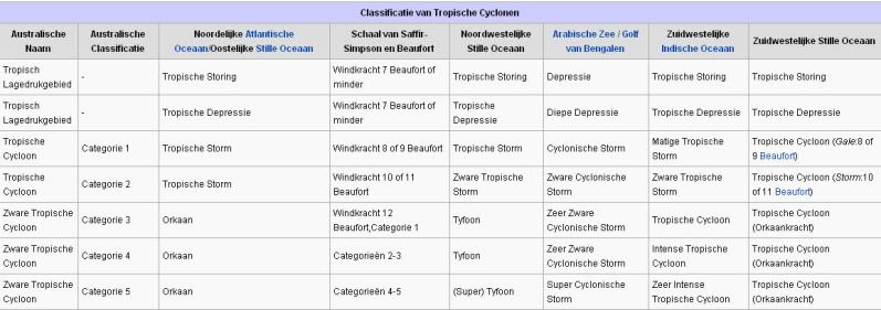
Indeling, Kracht en Stormvloed
De stormen worden ingedeeld op 'categorie'. Vaak zijn het eerst tropische stormen" (Tropical Depression, Tropical Storms), die overgaan tot Orkaanstatus (Hurricanes/Tyfoons) Ze worden ingedeeld op windsnelheden via de Saffir-Simpson Schaal.
Door de enorme windkracht van een orkaan wordt het zeewater opgestuwd. Dit zeewater wordt als het ware vooruit geblazen, voor de storm uit. Hoe zwaarder de orkaan des te meer zeewater vooruit wordt geduwd. De stormvloed wordt dan ook gemeten bovenop de reguliere golfslag. Je kan het enigszins vergelijken met een muur van water (tsunami) die vooruit wordt geduwd.
Tropische Depressie: windsnelheden van 38 tot 61 km/u
Tropische Storm: windsnelheden van 62 tot 118 km/u
Orkaan 1e categorie: windsnelheden van 119 tot 153 km/u en een stormvloed van 1 tot 1,5 meter boven normaal
Orkaan 2e categorie: windsnelheden van 154 tot 177 km/u en een stormvloed van 1,5 tot 2,5 meter boven normaal
Orkaan 3e categorie: windsnelhden van 178 tot 209 km/u en een stormvloed van 2,5 tot 3,7 meter boven normaal
Orkaan 4e categorie: windsnelheden van 210-249 km/u en een stormvloed van 3,8 tot 5,5 meter boven normaal
Orkaan 5e categorie: windsnelheden > 250 km/u en een stormvloed van meer dan 5,5 meter boven normaal
Onderstaand schema geeft de kracht en benaming van orkanen overal ter wereld weer
TIP: Interactief (film)overzicht van de krachten van orkanen n.a.v. de schaal van Simpson
Waarom hebben orkanen namen?
De Tropische Depressies worden overal ter wereld in de gaten gehouden en zodra de depressies uitgroeien tot orkaan of cycloon, wordt er een naam aan de storm gegeven. Sinds 1950 krijgen ze namen op alfabetische volgorde (met uitzondering van de letters Q, U, X, Y en Z). Mocht een orkaan vernietigend hebben huisgehouden zoals Floyd, Gilbert en bijv. Katrina, dan zal die naam worden vervangen. Soms komt het ook voor dat alle letters van het alfabet gebruikt zijn in één seizoen (zoals 2005), dan zal een volgende storm Alpha gaan heten, gevolgd door Beta etc etc. Voor het orkanenseizoen 2012 zijn de namen als volgt:
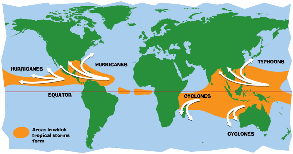
Waar komen orkanen eigenlijk voor?
Onderstaand kaartje geeft aan waar zogenoemde orkanen, cyclonen en tyfoons voorkomen en welke kant ze op gaan.
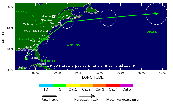
Atlantische Stormen 2013
Dit zijn de namen van de Atlantische Depressies en Orkanen voor 2013:

In het Noordoosten van de Pacific ontstaan ook orkanen. Deze orkanen zorgen vaak voor overlast in Midden-Amerika en delen van Mexico.
Oost Pacifische Stormen 2013
Dit zijn de namen van de (Oost)Pacifische Depressies en Orkanen voor 2013:
Alvin, Barbara, Cosme, Dalila, Erick, Flossie, Gil, Henriette, Ivo, Juliette, Kiko, Lorena, Manuel, Narda, Octave, Priscilla, Raymond, Sonia, Tico, Velma, Wallis, Xina, York, Zelda
Verder zijn er dan nog de stormen in het Noordwesten, Midden en Zuiden van de Pacific. Daar worden ze tyfoons en/of cyclonen genoemd. Vooral de stormen in het Noord/Westen komen vaak in het nieuws omdat ze Japan, de Filipijnen, Taiwan en China vaak teisteren, maar ook geheel Zuid Oost Azië kunnen treffen. Ook in de Indische oceaan komen ze voor, daar zijn vaak Bangladesh en Myanmar aan de beurt, maar soms ook India, Pakistan of zelfs Oman.
Meer informatie over de namen van orkanen vind je hier.
Leuk hoor allemaal, maar wanneer zijn die orkaanseizoenen nou precies?
ATLANTISCHE OCEAAN: 1 juni t/m 30 november, met pieken eind augustus en september
NOORD OOST PACIFIC:Begin mei t/m begin november, met piek in augustus/september
NOORD WEST PACIFIC: Begin juli t/m eind november, maar eigenlijk hele jaar door activiteit.
NOORD INDISCHE OCEAAN: april t/m december met pieken in mei en november
ZUID INDISCHE + WEST AUSTRALISCHE OCEAAN: oktober t/m mei met pieken in februari en april
ZUID WEST PACIFIC + OOST AUSTRALISCHE OCEAAN: oktober tot eind april met piek in februari.
Over het algemeen is Mei de rustigste maand en September de zwaarste.
En? Zijn er al verwachtingen en/of voorspellingen voor 2013?
In december 2011 zijn de eerste lange termijn verwachtingen naar buiten gekomen. TSR (Tropical Storm Risk) kwam met een ietwat boven gemiddeld orkaanseizoen. Volgens hen ligt de activiteit van het tropische seizoen 49% boven het meerjarig gemiddelde van 1950-2010 met 14 tropische stormen, 7 orkanen en 3 zware orkanen.
Weather Service International (WSI) kwam eind december met een nagenoeg gemiddeld orkaanseizoen. Een zwakkere LaNina en een koele Noord Atlantische Oscillatie, eentje die al een decennia niet meer voorgekomen is, maken er een gemiddeld seizoen van. 12 tropische stormen, 7 orkanen en ook 3 zware orkanen.
In april 2013 zal er een definitieve versie komen van de voorspellingen.
Waait het nou echt zo hard bij zo'n orkaan?
Oude delen van Hurricane Season vind je hier:
Topicreeks: Hurricane Season
Enkele Links en Leesvoer
1. National Hurricane Centre
2. Carribean Storm Network
3. Hurricanezone
4. Hurricane Track
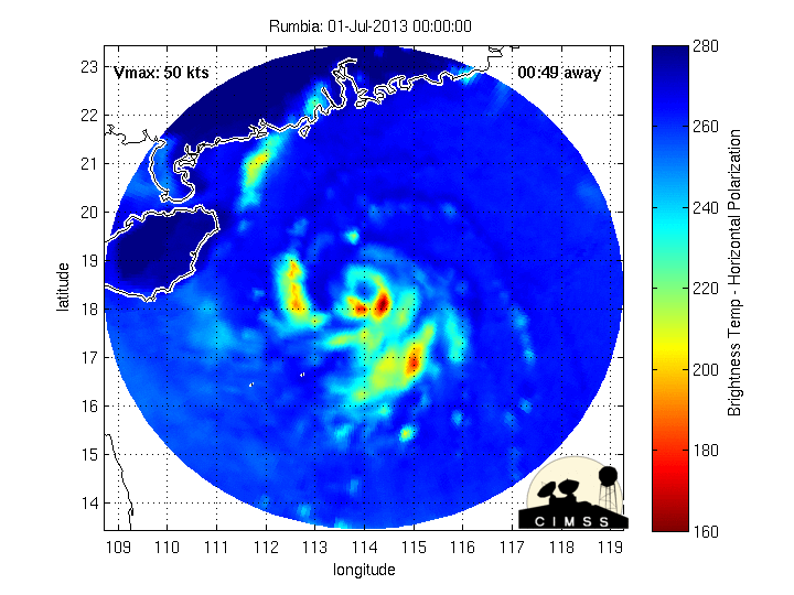
5. Website met satelietbeelden van de Caribbean en de rest van Amerika
6. Intellicast: Geavanceerde satellietfoto's en gifs van aktuele stormen
7. Tropical Weather Underground
8. Tropical Storm Risico's van dit moment
9. Wikipedia Hurricanes/Tyfonen in het algemeen
10. Alle stormen ter wereld van de laatste jaren in overzicht
11. The StormTrack
12. Orkanensite in de Filipijnen
13. Atlantische Orkanensite
14. Actuele orkanen in Australië en De orkaanindeling in Australië
15. Tropische weersite omgeving Australië
16. Mooie site over Orkanen aan de VS kusten
17. Website van NASA over Hurricanes
18. Windrapporten wereldwijd
19. Storm2k - Amerikaans weerforum
Opmerkelijke Wikipedia-Links
-- Hurricane Katrina 2005
-- Cyclone Nargis 2008
-- Hurricane Season 2013 - Wikipedia
-- Hurricane Season 2012 - Wikipedia
-- Hurricane Season 2011 - Wikipedia
-- Hurricane Season 2010 - Wikipedia
-- Hurricane Season 2009 - Wikipedia
-- Hurricane Season 2008 - Wikipedia
-- Hurricane Season 2007 - Wikipedia
-- Hurricane Season 2006 - Wikipedia
-- Hurricane Season 2005 - Wikipedia
-- Hurricane Season 2004 - Wikipedia
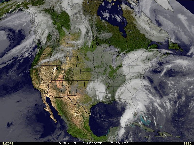
Actuele Weerradar in Golf van Mexico

Actuele Water temperatuur.


Laatste post uit #2 van 2012
Cyclone Narelle, mogelijk categorie 3 of zelfs 4... richting de Noordwestkust van Australië
Cyclone Narelle, mogelijk categorie 3 of zelfs 4... richting de Noordwestkust van Australië


<a href="http://www.vwkweb.nl/" rel="nofollow" target="_blank">[b]Vereniging voor weerkunde en klimatologie[/b]</a>
<a href="http://www.estofex.org/" rel="nofollow" target="_blank">[b]ESTOFEX[/b]</a>
<a href="http://www.estofex.org/" rel="nofollow" target="_blank">[b]ESTOFEX[/b]</a>


Nope... Deze supercell is ontstaan op land... En stukken kleiner dan een cyclonequote:Op vrijdag 11 januari 2013 17:42 schreef Co_OL het volgende:
weet niet of het bij het systeem hoort bij onslow
[ afbeelding ]
<a href="http://www.vwkweb.nl/" rel="nofollow" target="_blank">[b]Vereniging voor weerkunde en klimatologie[/b]</a>
<a href="http://www.estofex.org/" rel="nofollow" target="_blank">[b]ESTOFEX[/b]</a>
<a href="http://www.estofex.org/" rel="nofollow" target="_blank">[b]ESTOFEX[/b]</a>
Van Low, naar Medium en nu High probability, in (als ik het goed heb) 24 uur...
Aloa, heb jij toegang tot kaarten die laten zien welke kant deze potentiele kandidaat opgaat?
THE AREA OF CONVECTION PREVIOUSLY LOCATED NEAR 12.1S
81.0E, IS NOW LOCATED NEAR 11.8S 80.3E, APPROXIMATELY 535 NM EAST-
SOUTHEAST OF DIEGO GARCIA. RECENT ANIMATED INFRARED SATELLITE
IMAGERY DEPICTS A CONSOLIDATING SYSTEM WITH DEEP CONVECTIVE
BANDING WRAPPING INTO A WELL-DEFINED LOW-LEVEL CIRCULATION CENTER
(LLCC). A 121427Z SSMIS MICROWAVE IMAGE SHOWS A COMPACT (120 NM
DIAMETER) SYSTEM WITH TIGHTLY-CURVED DEEP CONVECTIVE BANDING TO THE
SOUTH AND IMPROVED CENTRAL CONVECTION. A 120331Z ASCAT IMAGE SHOWS A
SYMMETRIC CIRCULATION WITH 25 TO 30 KNOT WINDS. THE SYSTEM
IS LOCATED JUST EQUATORWARD OF THE SUBTROPICAL RIDGE AXIS AND IS
UNDER MODERATE TO STRONG (20 TO 30 KNOTS) VERTICAL WIND SHEAR.
HOWEVER, THE DYNAMIC MODELS INDICATE FURTHER DEVELOPMENT AS THE
SYSTEM TRACKS INTO A MORE FAVORABLE UPPER-LEVEL ENVIRONMENT OVER THE
NEXT 24 HOURS. MAXIMUM SUSTAINED SURFACE WINDS ARE ESTIMATED AT 25
TO 30 KNOTS. MINIMUM SEA LEVEL PRESSURE IS ESTIMATED TO BE NEAR 1004
MB. SEE REF B (WTXS21 PGTW 121530Z) FOR FURTHER DETAILS. THE
POTENTIAL FOR THE DEVELOPMENT OF A SIGNIFICANT TROPICAL CYCLONE
WITHIN THE NEXT 24 HOURS IS UPGRADED TO HIGH.
Sat Foto (deze wordt door de site constant geupdate)

at your service

Komt wel de kant van Mauritius op. Duurt nog wel even, maar gfs laat wel cat 1 of 2 zien.quote:
Van Low, naar Medium en nu High probability, in (als ik het goed heb) 24 uur...
Aloa, heb jij toegang tot kaarten die laten zien welke kant deze potentiele kandidaat opgaat?
THE AREA OF CONVECTION PREVIOUSLY LOCATED NEAR 12.1S
81.0E, IS NOW LOCATED NEAR 11.8S 80.3E, APPROXIMATELY 535 NM EAST-
SOUTHEAST OF DIEGO GARCIA. RECENT ANIMATED INFRARED SATELLITE
IMAGERY DEPICTS A CONSOLIDATING SYSTEM WITH DEEP CONVECTIVE
BANDING WRAPPING INTO A WELL-DEFINED LOW-LEVEL CIRCULATION CENTER
(LLCC). A 121427Z SSMIS MICROWAVE IMAGE SHOWS A COMPACT (120 NM
DIAMETER) SYSTEM WITH TIGHTLY-CURVED DEEP CONVECTIVE BANDING TO THE
SOUTH AND IMPROVED CENTRAL CONVECTION. A 120331Z ASCAT IMAGE SHOWS A
SYMMETRIC CIRCULATION WITH 25 TO 30 KNOT WINDS. THE SYSTEM
IS LOCATED JUST EQUATORWARD OF THE SUBTROPICAL RIDGE AXIS AND IS
UNDER MODERATE TO STRONG (20 TO 30 KNOTS) VERTICAL WIND SHEAR.
HOWEVER, THE DYNAMIC MODELS INDICATE FURTHER DEVELOPMENT AS THE
SYSTEM TRACKS INTO A MORE FAVORABLE UPPER-LEVEL ENVIRONMENT OVER THE
NEXT 24 HOURS. MAXIMUM SUSTAINED SURFACE WINDS ARE ESTIMATED AT 25
TO 30 KNOTS. MINIMUM SEA LEVEL PRESSURE IS ESTIMATED TO BE NEAR 1004
MB. SEE REF B (WTXS21 PGTW 121530Z) FOR FURTHER DETAILS. THE
POTENTIAL FOR THE DEVELOPMENT OF A SIGNIFICANT TROPICAL CYCLONE
WITHIN THE NEXT 24 HOURS IS UPGRADED TO HIGH.
Sat Foto (deze wordt door de site constant geupdate)
[ afbeelding ]
Narelle trekt netjes langs de kust van Australië. Ik vraag me af of ze met het volgende systeem wat er aan lijkt te komen net zoveel geluk hebben..

Tnx! gebruik je weatheronline om dit te zien? ik zie de storing wel deze kant op komen (GFS), maar de voorspelling over de sterkte kan ik nergens terug vinden.quote:Op zaterdag 12 januari 2013 19:09 schreef aloa het volgende:
Komt wel de kant van Mauritius op. Duurt nog wel even, maar gfs laat wel cat 1 of 2 zien.
at your service
Deze kan je ook gebruiken. Dat zwarte gedeelte is meer dan 50 knopen. http://www.windfinder.com/forecasts/wind_africa186.htmquote:
[..]
Tnx! gebruik je weatheronline om dit te zien? ik zie de storing wel deze kant op komen (GFS), maar de voorspelling over de sterkte kan ik nergens terug vinden.


Dit kan voor wateroverlast gaan zorgen in Queensland. Tropische storm Oswald blijft volgens ECMWF dagen boven het noorden van Australie liggen.
Alle neerslag tot 29 januari

Alle neerslag tot 29 januari


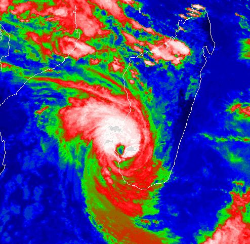
Felleng groeit nogsteeds en nu wordt er voorspelt dat deze donderdag cat 3 kan worden:
Gelukkig raast deze cycloon netjes tussen Madagascar en Reunion richting het zuiden. Vooralsnog is er weinig te merken op Mauritius, hoewel er een behoorlijke bak water wordt verwacht in de nacht van vrijdag op zaterdag.
[ Bericht 10% gewijzigd door the_butler op 29-01-2013 10:48:23 ]
Gelukkig raast deze cycloon netjes tussen Madagascar en Reunion richting het zuiden. Vooralsnog is er weinig te merken op Mauritius, hoewel er een behoorlijke bak water wordt verwacht in de nacht van vrijdag op zaterdag.
[ Bericht 10% gewijzigd door the_butler op 29-01-2013 10:48:23 ]
at your service
Kan idd een cat 4 worden. Madagascar heeft waarschijnlijk geluk dat het geen voltreffer gaat krijgen, maar kan zeker veel neerslag verwachten.

Cat 4 zie ik nu ook op wunderground... echt geluk dat al het vaste land wordt gemist.
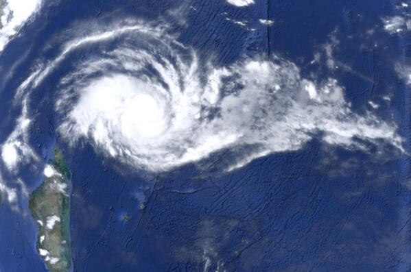
Gisteren was er een erg mooie sateliet foto die duidelijk het oog liet zien, ook op wunterground, maar deze is nu vervangen door een infrarood exemplaar. (edit - gevonden!)
Als je goed kijkt zie zag (dat is het probleem met auto updatende gif's) je de bliksem in de GIF hierboven... wat een storm
[ Bericht 15% gewijzigd door the_butler op 30-01-2013 13:09:36 ]
Gisteren was er een erg mooie sateliet foto die duidelijk het oog liet zien, ook op wunterground, maar deze is nu vervangen door een infrarood exemplaar. (edit - gevonden!)


Als je goed kijkt zie zag (dat is het probleem met auto updatende gif's) je de bliksem in de GIF hierboven... wat een storm
[ Bericht 15% gewijzigd door the_butler op 30-01-2013 13:09:36 ]
at your service
Ik kan me inschrijven voor een congres half november in Orlando, Florida. Zit te denken om er enkele dagen vakantie in Florida aan vast te plakken, maar is het wel verstandig, ivm hurricane season? Of is de kans dat er iets gebeurd lang niet zo groot als "wij" aan deze kant van de oceaan denken?
gewoon gaan, zo'n kans laat je tocch niet glippen? De kans dat jij niet iets op je dak krijgt is erg klein, en tja, persoonlijk lijkt het me wel wat om getuige te zijn van zoveel natuurgeweld (met kant tekening dat ik gesproken heb met mensen die in 1 maand twee maal een cat 4 op hun dak kregen - dat is niet leuk meer, geen electriciteit voor weken, schoon water en voedsel wordt een groot probleem, overal muskieten... bende) Maar in Amerika is het denk ik wel redelijk geregeld...quote:
Ik kan me inschrijven voor een congres half november in Orlando, Florida. Zit te denken om er enkele dagen vakantie in Florida aan vast te plakken, maar is het wel verstandig, ivm hurricane season? Of is de kans dat er iets gebeurd lang niet zo groot als "wij" aan deze kant van de oceaan denken?
at your service
Augustus en September zijn de topmaanden van Hurricane Season, in November gebeurd er niet vaak nog iets dus gewoon doenquote:
Ik kan me inschrijven voor een congres half november in Orlando, Florida. Zit te denken om er enkele dagen vakantie in Florida aan vast te plakken, maar is het wel verstandig, ivm hurricane season? Of is de kans dat er iets gebeurd lang niet zo groot als "wij" aan deze kant van de oceaan denken?
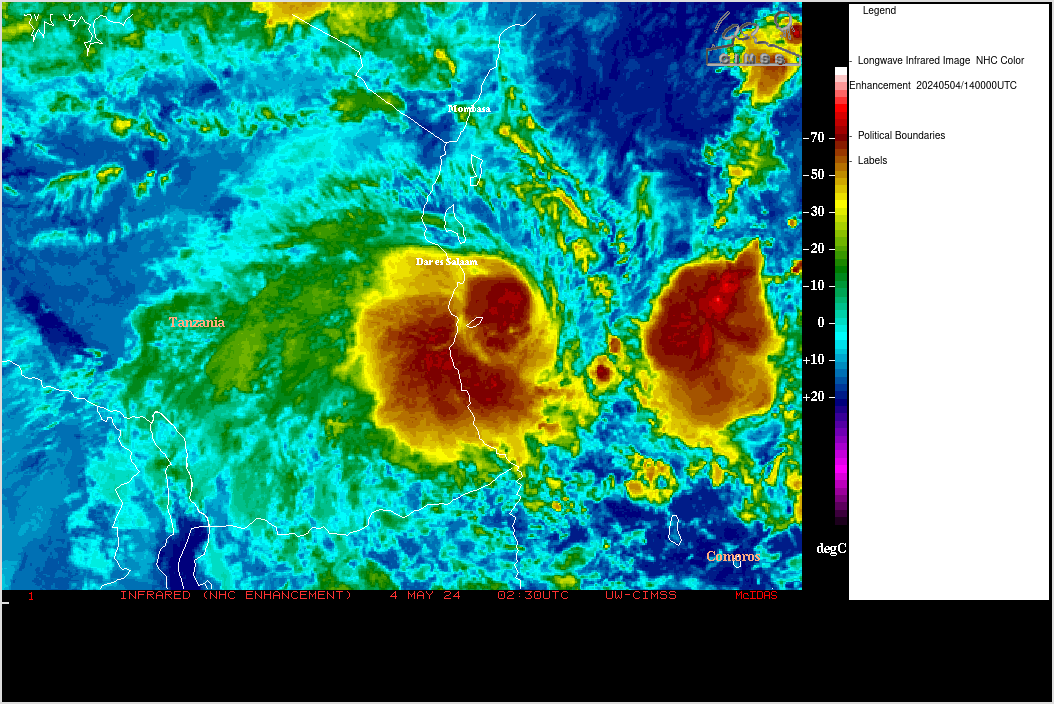
Zes doden na doortocht cycloon Felleng op Madagaskar
De doortocht van cycloon Felleng heeft zes mensenlevens gekost op Madagaskar. Drie mensen zijn nog vermist. Dat melden de Malagassische autoriteiten.
"Felleng is ondertussen verder getrokken. Naast de doden en vermisten zijn er in de hoofdstad Antananarivo 800 mensen dakloos geworden", zegt Raymond Randriatahina van het nationale bureau voor rampenbeheer.
De hoofdstad werd het zwaarst getroffen door Felleng. Honderden huizen zijn er overstroomd nadat de rivier Mamba buiten haar oevers getreden was.
hln


2e TS Haley lijkt ook niet voor veel overlast te gaan zorgen. Mogelijk veel neerslag op wat eilandjes in de buurt. Uiteindelijk wordt het opgenomen in een stormdepressie die richting Chili koerst.

Na al het nieuws over meteorieten een vraag over cycloontjes, deze jongen wordt voorspelt door het GFS model van weatheronline. Het is een groffe schatting en het model is niet betrouwbaar omdat het zo ver in de toekomst ligt. Ik zou heel graag een second opineon of een ander model zien, kijken hoeveel kans er is dat er over twee weken een joekel voor de deur ligt... iemand een suggestie?
Ik neem even aan dat deze gif niet auto-update, tijdens dit schrijven 16/02/13 staat er een erg laag druk gebied (bijna gegarandeed een cycloon) letterlijk bovenop Mauritius
Ik neem even aan dat deze gif niet auto-update, tijdens dit schrijven 16/02/13 staat er een erg laag druk gebied (bijna gegarandeed een cycloon) letterlijk bovenop Mauritius

at your service
Kan zomaar idd. Nu nog veel te ver weg. Op die termijn kan er nog van alles gebeuren.quote:
Na al het nieuws over meteorieten een vraag over cycloontjes, deze jongen wordt voorspelt door het GFS model van weatheronline. Het is een groffe schatting en het model is niet betrouwbaar omdat het zo ver in de toekomst ligt. Ik zou heel graag een second opineon of een ander model zien, kijken hoeveel kans er is dat er over twee weken een joekel voor de deur ligt... iemand een suggestie?
Ik neem even aan dat deze gif niet auto-update, tijdens dit schrijven 16/02/13 staat er een erg laag druk gebied (bijna gegarandeed een cycloon) letterlijk bovenop Mauritius
[ afbeelding ]
Andere modellen zijn er niet (ik ken ze in ieder geval niet) die zo ver gaan.
Tussen Mozambique en Madagascar (Straat Mozambique) een tropische storm / orkaan. Deze kan voor overlast gaan zorgen.


Tropische depressie nu. Maar vaak zitten ze idd wat hoger in de pacific.quote:Op woensdag 20 februari 2013 19:33 schreef Lemans24 het volgende:
[..]
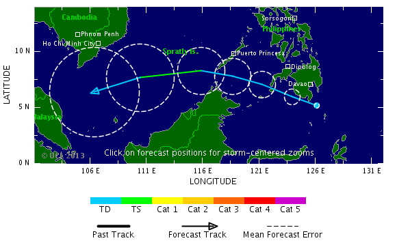
Ongebruikelijke route, daar bij Borneo. Is echter hooguit een tropische storm, zo te zien.

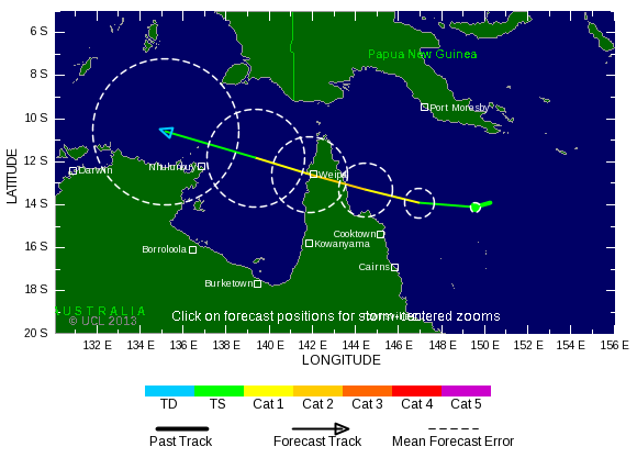
Australië gaat ook een orkaan krijgen binnenkort. Kan een zware worden. GFS, ECMWF, NOGAPS en UKMO laten het allemaal zien aan de noordwest kant van Australie en laten het systeem het land intrekken.


Waarschuwing van de BOM
A low [10U] in the Northern Region near 11S 129E is slowly developing and is
expected to move into the Western Region during Friday or early Saturday. This
low may develop into a tropical cyclone late on Saturday or on Sunday. Next
week there is a significant risk that this system will become a severe tropical
cyclone and impact the Pilbara or West Kimberley. People in the Pilbara and
Kimberley are advised to stay up to date with weather forecasts and warnings.
There are no other significant lows and none are expected to develop over the
next three days.
Likelihood of this system being a tropical cyclone in the Western Region on:
Friday Low
Saturday Moderate
Sunday High


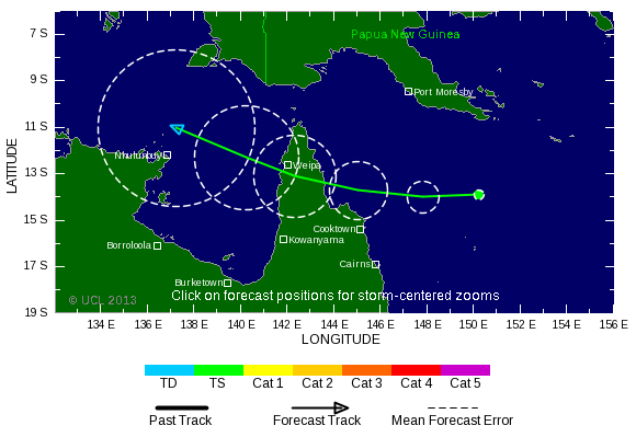
Haruna heeft inmiddels landfall gemaakt op Madagascar en trekt nu over het zuiden, waar het langzaam in kracht zal afnemen.

Zal wel van TD18 zijn ?quote:Cocos Islands in the Indian Ocean have received an astonishing 831.2mm (32.7") rain in 3 days from an as yet unnamed tropical depression
Klopt ja.quote:
Van Rusty wordt ook al een meter neerslag verwacht.
quote:Haruna maakt 18 slachtoffers op Madagascar
De orkaan Haruna en de bijbehorende regenbuien hebben in Madagaskar al aan minstens 18 mensen het leven gekost. Nog 16 anderen zijn vermist. In een week tijd werden ongeveer 22.000 mensen getroffen door de ramp. Dat staat te lezen in een voorlopige balans van het lokale bureau voor risicobeheer bij rampen (BNGRC).
De orkaan Haruna kwam vrijdagochtend aan land in de regio van Morombe, in het zuidwesten van Madagaskar. 24 uur later verliet Haruna het eiland nadat ze meerdere steden overstroomd en vernield had. De vele getroffenen zaten gevangen door de hoge stand van het water en moesten geëvacueerd worden.
"De voorlopige balans in het zuiden van Madagaskar staat op 18 doden, 16 vermisten, 81 gewonden en 22.498 getroffenen", gaf het BNGRC aan.
Op vrijdag en zaterdag viel er enorm veel neerslag, maar zondag werd het weer opnieuw beter. De luchthaven van Tuléar werd zondag dan ook opnieuw geopend.
De orkaan heeft ongeveer 1.000 woningen vernield waardoor bijna 10.000 mensen dakloos geworden zijn. Ondertussen werden al 40 noodhulpcentra ingericht en is het materiaal voor de hulpverlening onderweg naar de regio.


GFS is het enige model wat met een duidelijke landfall komt in Queensland. Dit model zat vorige week wel goed met de koers van Rusty. Momenteel is het een high risk.


zit je daar nu nog?quote:
Felleng groeit nogsteeds en nu wordt er voorspelt dat deze donderdag cat 3 kan worden:
[ afbeelding ]
[ afbeelding ]
Gelukkig raast deze cycloon netjes tussen Madagascar en Reunion richting het zuiden. Vooralsnog is er weinig te merken op Mauritius, hoewel er een behoorlijke bak water wordt verwacht in de nacht van vrijdag op zaterdag.
nu wel overstromingen en dodelijke slachtoffers daar
Ja ik zit hier nog, vandaag een dag van nationale rouw... Waar ik woon viel gelukkig niet zoveel, het regende wel hard en de electriciteit viel uit maar dat was het wel. Alle bomen hier staan er nog en de rivier achter het huis is niet uit ze'n oevers getreden. Wat de situatie in Port Louis is hoor ik net als jou van de kranten enzo, maar het moet chaos geweest zijn, 153mm regen in drie uur...quote:
zit je daar nu nog?
nu wel overstromingen en dodelijke slachtoffers daar
En iedereeen wijst naar de meteo en de regering omdat er geen waarschuwing / voorspelling was. Mischien komt dat omdat een maand terug er wel gewaarschuwd werd (alle scholen en publieke sector moesten dicht) en niet viel er niet zoveel.
Als ik meer weet hoor je het, modellen voorspellen trouwens ook cycloon deze zaterdag, ver onder India, kijken waar die terecht gaat komen...
[kleine update] Mijn collega was zaterdag in de buurt bij een paardenrace, hij zat er midden in. Het evenement werd na de eerste race gestopt en iedereen ging weg. Gelukkig bleef hij op de hoog gelegen wegen, want hij zag al welke kant dit op zou gaan. Onderweg zag hij heel veel blikschade aan autos, weg verzakkingen en modder stromen die over de (snel) weg heen trokken. De doden waren te betreuren in de lange voetgangers tunnel die naar het toeristische sea front leidde. Zoals ik al zei fungeerde de wegen als rivier dus al dat water ging maar een kant op, recht die tunnel in. Ik hoor ook dat het huis van een Mauritiaanse collega overstroomd is, hij vroeg of hij van onze bouwplaats (die ook beschadigd is) zandzakken en hout mocht lenen. Dat mocht uiteraard en morgen zullen we met de pet rond gaan om zijn gezinnetje wat steun te geven.
...ondertussen schijnt hier in Black River de zon weer, is het 28 graden en ziet het er uit alsof er niks gebeurt is
[ Bericht 13% gewijzigd door the_butler op 01-04-2013 06:58:09 (typo) ]
at your service
Zoals waarsch bekend woon ik op Mauritius waar afgelopen weekend 11 mensen waaronder 6 kinderen verdronken waren door plotselinge hevige regen. Ik kreeg net deze email binnen, deze laat weer eens goed zien dat het vertrouwen in de lokale meteo in een dieptepunt zit...
--------------------------------------------------------------
Dear all,
I am sharing this with you because I think it is of utmost importance.
In its weather bulletin last night and this morning, the BBC made a complete review of the situation in Mauritius and they forecast more torrential rain in Mauritius as from this Thursday.
The bad weather is to last until next week.
As we cannot rely on our own Meteorological services to get valuable information in time, I think it is my duty to share this with you, as I am aware of the information.
Please note that Météo France and the American weather station based in Diego Garcia have gone even further than the BBC and are announcing – on top of more torrential rainfall – the formation of a cyclone that would concern us directly around next week.
Hereunder is the video link to the full BBC broadcast.
Best regards to all of you,
http://www.bbc.co.uk/weather/features/21996944
at your service
Lijkt weer een systeem die kant op te gaan. Nog onduidelijk waar deze heen gaat, want alle modellen laten weer wat anders zien. Maar komt wel weer wat in die buurt.quote:
Zoals waarsch bekend woon ik op Mauritius waar afgelopen weekend 11 mensen waaronder 6 kinderen verdronken waren door plotselinge hevige regen. Ik kreeg net deze email binnen, deze laat weer eens goed zien dat het vertrouwen in de lokale meteo in een dieptepunt zit...
--------------------------------------------------------------
Dear all,
I am sharing this with you because I think it is of utmost importance.
In its weather bulletin last night and this morning, the BBC made a complete review of the situation in Mauritius and they forecast more torrential rain in Mauritius as from this Thursday.
The bad weather is to last until next week.
As we cannot rely on our own Meteorological services to get valuable information in time, I think it is my duty to share this with you, as I am aware of the information.
Please note that Météo France and the American weather station based in Diego Garcia have gone even further than the BBC and are announcing – on top of more torrential rainfall – the formation of a cyclone that would concern us directly around next week.
Hereunder is the video link to the full BBC broadcast.
Best regards to all of you,
http://www.bbc.co.uk/weather/features/21996944

Ai, GFS run van deze morgen zet em een stuk dichter bij! Het is ook een lomp groot systeem zeg...quote:
Lijkt weer een systeem die kant op te gaan. Nog onduidelijk waar deze heen gaat, want alle modellen laten weer wat anders zien. Maar komt wel weer wat in die buurt.
Nou ja, als het mee (of tegen) zit kan ik volgende week live verslag doen van een CAT 4 lijkt het zo.

Ondertussen is er door de regering voor vandaag een weer alarm afgegeven, omdat er zware regenval net als vorige week wordt voorspelt. Tijdens dit schrijven kijk ik naar een blauwe lucht met hier en daar een wolk... welkom in Afrika zucht.
---------------------------------
edit 5/04/13 20:00
Weer een nieuwe GFS binnen... nu begin ik me toch lichtelijk zorgen te maken, ik loop dan wel te grappen dat ik eens een cycloon mee wil maken, maar deze lijkt op deze manier Mauritius full on te raken... Toch maar wat water, bloem en een extra gasflesje inslaan denk ik zo...


Vrijdag 12 April 9pm
[ Bericht 12% gewijzigd door the_butler op 05-04-2013 20:16:51 ]
at your service

Op deze kaart kan je Mauritius heel goed zien, er staan tien cirkeltjes omheen getekend....

at your service
Ziet er niet goed uit (al is het wel lange termijn). Kijken wat EC straks laat zien.quote:
Op deze kaart kan je Mauritius heel goed zien, er staan tien cirkeltjes omheen getekend....
[ afbeelding ]


Het is nog steeds lange termijn, maar volgens gfs gaat dit systeem precies op Mauritius en Réunion ergens aan land komen (cycloon komt zeer gevaarlijk in de buurt). EC laat het iets meer aan de oostkant langs trekken.

De modellen plaatsen het pad van de Cycloon steeds verder naar het oosten, dus met een beetje mazzel blijft het oog uit de buurt. Lokale bevolking lijkt zich nog niet erg bewust te zijn van wat er mischien komen gaat. Vrienden en kennissen hebben de houding dat afgelopen Cycloon over Reunion ook reuze meeviel en dat het deze keer ook wel wat winderig zal zijn, maar niett meer dan dat. Ik ben het daar toch niet helemaal mee eens.
Maar goed we zullen zien
Maar goed we zullen zien
at your service
Van JTWC... http://www.usno.navy.mil/(...)rnings/sh2113web.txt
THOUGH DYNAMICAL
MO1DEL GUIDANCE IS IN GENERALLY GOOD AGREEMENT WITH THE POLEWARD
DEFLECTION IN THE EXTENDED FORECAST, THE TIMING AND SHARPNESS IN THE
DEFLECTION ARE STILL UNCLEAR. THIS IS FURTHER EVIDENCED BY
INCREASING SPREAD NOTED IN ENSEMBLE MODEL PRODUCTS. THE OFFICIAL
FORECAST IS VERY SIMILAR TO THE PREVIOUS FORECAST, WITH THE POLEWARD
DEFLECTION NOW BECOMING MORE EVIDENT IN THE LATER TAUS. THERE IS
HIGH CONFIDENCE IN THE THREE DAY FORECAST, BUT LOW CONFIDENCE IN THE
EXTENDED PORTION.
Kortom, de modellen kunnen het niet eens worden, hoe langer de Cycloon westwaarts kan bewegen, hoe krachtiger deze wordt door de warme zee temperatuur. Vandaar dat modellen tussen CAT 2 en CAT 4 voorspellen - een snelle afbuiging naar de pool levert een zwakkere cycloon op. Het is dus gewoon afwachten tot dinsdag avond denk ik.
at your service
Het slechtste scenario is, als het oog aan de oostkant passeert. zwaarste windveld ligt aan de rechterkant van de cycloon.quote:
De modellen plaatsen het pad van de Cycloon steeds verder naar het oosten, dus met een beetje mazzel blijft het oog uit de buurt. Lokale bevolking lijkt zich nog niet erg bewust te zijn van wat er mischien komen gaat. Vrienden en kennissen hebben de houding dat afgelopen Cycloon over Reunion ook reuze meeviel en dat het deze keer ook wel wat winderig zal zijn, maar niett meer dan dat. Ik ben het daar toch niet helemaal mee eens.
Maar goed we zullen zien
GFS laat het nu ook weer meer oostelijk gaan. Afwachten maar.
Modellen komen steeds dichter bij elkaar. Systeem trekt zo'n beetje over Rodrigues heen. Maar de andere eilanden krijgen zeker te maken met slagregens, hoge golven etc.
Moet toch al minimaal een cat 1 zijn, als je onderstaand plaatje bekijkt.
Moet toch al minimaal een cat 1 zijn, als je onderstaand plaatje bekijkt.

Het beestje heeft ondertussen een naampje gekregen, Imelda. Iedere nieuwe voorspelling zet Imelda verder weg naar het westen, maar JTWC zeg dat het nogsteeds zeer onzeker is wat er over 48 uur gaat gebeuren.
[ Bericht 0% gewijzigd door the_butler op 08-04-2013 15:13:49 (typo) ]
[ Bericht 0% gewijzigd door the_butler op 08-04-2013 15:13:49 (typo) ]
at your service

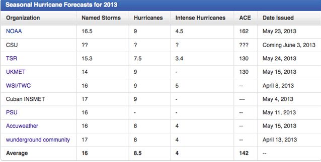
2013 Hurricane Season Outlook: Active Season Ahead
The forecast calls for a total of 16 named storms, 9 of which are expected to become hurricanes, including 5 major hurricanes
The forecast calls for a total of 16 named storms, 9 of which are expected to become hurricanes, including 5 major hurricanes
http://www.weather.com/ne(...)tlook-april-20130408quote:The Weather Channel has released its first 2013 Atlantic hurricane season outlook, calling for another active season.
The forecast calls for a total of 16 named storms, 9 of which are expected to become hurricanes, including 5 major hurricanes (Category 3 or higher on the Saffir-Simpson Hurricane Wind Scale).
These forecast numbers are above the long-term average from 1950-2012 (12 named storms, 7 hurricanes, 3 major hurricanes) and slightly above the averages for the current active era from 1995-2012 (15 named storms, 8 hurricanes, 4 major hurricanes).
Three straight Atlantic hurricane seasons have had 19 storms. Only seven Atlantic seasons have had more hurricanes than last season's 10 hurricanes. Among the four U.S. landfalls were the most intense tropical cyclone to make a U.S. landfall prior to June 1 (Tropical Storm Beryl), a soaking Tropical Storm Debby, a painfully slow Hurricane Isaac, and one of the most destructive storms in U.S. history, Superstorm Sandy. (Sandy became a "post-tropical" system shortly before landfall.)
One particular meteorological field has long-range forecasters concerned about 2013.
"One of the side effects of the anomalous weather pattern during March was a sharp increase in sea surface temperatures in the tropical North Atlantic," said Dr. Todd Crawford, Chief Meteorologist for Weather Services International (WSI), a part of The Weather Company.
"While it is still three months before hurricane season officially begins, this early warming of the tropical waters is an indication that an active season is in store, and our statistical forecast models confirm this hypothesis," said Crawford. "Our current forecast...may be a bit conservative if the warm tropical ocean temperatures persist heading into the season."
With that said, there may be another factor that may oppose the effect of warmer-than-average ocean temperatures.
"The one potential fly in the ointment is the possible emergence of an El Nino event this summer," said Crawford.
Stronger wind shear, a nemesis to tropical cyclone development, tends to appear in parts of the Atlantic Basin in a season in which El Nino has developed.
(MORE: What is El Nino? | Origination)
"At this point, climate and statistical model solutions suggest that this outcome (El Nino) is not particularly likely, however," said Crawford.
History Shows Be Prepared Every Season!
Key hurricane season prediction statements
"Through scientists at WSI, The Weather Channel has been producing hurricane seasonal forecasts for the Atlantic Ocean since 2006," says Dr. Peter Neilley, Vice President, Global Forecasting Services.
"The forecasts are based on state-of-the-science techniques and inputs such as patterns of ocean temperatures in both the Atlantic and Pacific Oceans. The Weather Channel forecasts have proven quite accurate and generally predict the number of storms within two each year."
"However, it is important to note that our forecasts are for the total number of storms that may occur anywhere within the Atlantic Ocean, and do not attempt to predict the number of storms that will make landfall in the U.S.," says Neilley.
(WeatherREADY: Hurricane safety tips)
Senior Meteorologist Stu Ostro (Facebook | Twitter) points out, "Some businesses such as those who are clients of Weather Services International (WSI) find value in hurricane season forecasts. The total number of storms is of interest to me because it matters for how busy I am during the season; for example, there wasn’t a U.S. hurricane landfall in either 2009 or 2010, but the former had 9 storms and the latter 19."
“These forecasts absolutely cannot accurately predict critical details such as where or how many landfalls will occur...”
Stu Ostro, Senior Meteorologist
"Nevertheless, as I am on record many times as saying, and as is The Weather Channel’s philosophy, these forecasts absolutely cannot accurately predict critical details such as where or how many landfalls will occur and people in hurricane-prone areas should be equally prepared every year regardless of seasonal outlooks."
Ostro adds, "In 1983 there were only four named storms, but one of them was Alicia, a Category 3 which hit the Houston-Galveston area and caused almost as many direct fatalities there as Andrew did in South Florida."
The 1992 season included four hurricanes and one U.S. landfall, Category 5 Hurricane Andrew.
"While the saying might appear trite, Andrew and Alicia exemplify that truly all it takes is one."
On the opposite side of the spectrum from those two relatively inactive hurricane seasons that each had a single devastating landfall was the 2010 season.
That year we saw a total of 12 hurricanes in the Atlantic Basin. In all, there were 19 named storms, which tied 1995 for the third most on record during a season.
(MORE: 2010 season recap)
The 2010 hurricane season included 12 hurricanes but no U.S. landfalls.
Despite the large number of storms that year, not a single hurricane and only one tropical storm made landfall in the United States.
That said, some U.S. impacts did occur, including four cyclones bringing tropical storm conditions to some part of the country. However, most of the damage and, in many cases, casualties occurred in other countries.
Lijkt mee te gaan vallen voor Mauritius. Cycloon buigt eerder af dan eerst werd voorspeld. Kan nog wel veel neerslag komen.
Inderdaad, we komen er goed mee weg, phew...
Dit wordt dan 18 jaar op rij dat er geen "direct hit" is geweest op Mauritius, het seizoen is nog niet af maar toch...
Dit wordt dan 18 jaar op rij dat er geen "direct hit" is geweest op Mauritius, het seizoen is nog niet af maar toch...
at your service

Is toch wel weer een stuk meer naar het westen bijgesteld.quote:
Inderdaad, we komen er goed mee weg, phew...
Dit wordt dan 18 jaar op rij dat er geen "direct hit" is geweest op Mauritius, het seizoen is nog niet af maar toch...

Klopt, het is morgen een vrije dag op het eiland, en ik zou eigenlijk een bootreisje maken met collega's. Maar er is net gebeld dat dit niet door kan gaan door het weer. De school van mijn dochtertje heeft ook een email de deur uit gedaan om vrijdag ochtend naar de radio te luisteren om te horen of de regering de scholen gesloten houd.
rustig afwachten, volgende GFS run duurt nog wel een paar uur, idem voor het volgende JTWC bulletin.
rustig afwachten, volgende GFS run duurt nog wel een paar uur, idem voor het volgende JTWC bulletin.
at your service
gfs is zelfs nog een stuk westelijker, dan de koers die nu wordt gevolgd door TSR. Die gaan waarschijnlijk uit van EC. Als je naar GFS en CMC kijkt dan krijgt Mauritius er zeker wel mee te maken. Zit toch wel een kracht 9 of meer in.
Nou, mischien toch wat spullen inslaan en wat foto's maken. Ik vrees dat de lokale minder bedeelde bevolking hier een probleem gaat krijgen, die wonen nog in golfplaten huisjes met een zeiltje erop.
at your service
Dat denk ik ook..quote:
Nou, mischien toch wat spullen inslaan en wat foto's maken. Ik vrees dat de lokale minder bedeelde bevolking hier een probleem gaat krijgen, die wonen nog in golfplaten huisjes met een zeiltje erop.
Het is nu nieuwe maan, dus over 2 dagen is het ook nog extra hoog water. Deze cycloon komt het meest dicht in de buurt over 2 a 3 dagen...(?)

Ze geven 72% kans voor een "major hurricane striking the US coast"... tegen gemiddeld 52%quote:Average forecast for 2013 hurricane season
The Atlantic Ocean will likely experience 16 named storms, nine hurricanes and five intense hurricanes during this year’s hurricane season from June 1 to Nov. 30, said an April 8 forecast by Weather Services International.
The Andover, Mass.-based forecasting service expects an active hurricane season, similar to the average of 15 named storms, eight hurricanes and four intense hurricanes recorded from 1995 through 2012.
Philip Klotzbach and William Gray of Colorado State University’s tropical meteorology project predicted in December a 40 percent chance of 12-15 named storms, seven-nine hurricanes and three-four major hurricanes. Their forecast will be updated April 10.
Irene, Sandy...kan zo weer raak zijn dit jaar aan de oostkust of deze keer weer ergens in de Golf..quote:
[..]
Ze geven 72% kans voor een "major hurricane striking the US coast"... tegen gemiddeld 52%
ik wacht nogsteeds op de nieuwe modellen voor Imelda, komst ze nog verder westwaarts? De wind hier begint trouwens op te steken, best vreemd - het is windstil en dan vijf minuten later waait het flink, en een half uur later is het weer bijna wind stil.... appart
at your service
Volgens mij maar 1 update per dag.. schiet niet echt op.quote:
ik wacht nogsteeds op de nieuwe modellen voor Imelda, komst ze nog verder westwaarts? De wind hier begint trouwens op te steken, best vreemd - het is windstil en dan vijf minuten later waait het flink, en een half uur later is het weer bijna wind stil.... appart

JTWC maakt er nog een categorie 3 van. Koers is niet veel veranderd..
quote:36 HRS, VALID AT:
120600Z --- 14.5S 57.2E
MAX SUSTAINED WINDS - 100 KT, GUSTS 125 KT
Mauritius lijkt de dans te ontspringen. Koers is behoorlijk naar het oosten bijgesteld. Rodrigues krijgt nu het meeste geweld over zich heen. TSR houd het nu op minimaal een cat1, de cycloon is nafgezwakt naar een TS.
quote:'Sandy' wordt vervangen door Sara
Nooit nog zal er een wervelstorm zijn met de naam Sandy. Volgens de Amerikaanse weerkundige dienst NOAA hebben de meteorologen die meisjesnaam geschrapt uit de lijst van wederkerende namen voor tornado's.
Een half jaar geleden veroorzaakte wervelstorm Sandy grote materiële en menselijke ravage in de Caraïben en vervolgens in de VS: 100 doden en een schade van enkele tientallen miljarden dollar. De gevolgen zijn op verscheidene plaatsen nog steeds te bespeuren.
Tientallen jaren geleden stelden de meteorologen een lijst met cycloonnamen op, die zich om de zes jaar herhaalt. Bij het begin van het orkaanseizoen worden die namen in alfabetische volgorde afgehaspeld.
Wanneer een storm té bekend wordt, vliegt hij uit de lijst. Zo zullen ook Andrew en Katrina nooit meer vernieling aanbrengen. Sandy wordt op haar beurt vervangen door Sara.
Van JTWC:
VWS VALUES ARE EXPECTED
TO INCREASE AS THE SYSTEM TRACKS POLEWARD, CONTRIBUTING TO THE
GRADUAL DISSIPATION BY TAU 36. THERE IS A DISTINCT POSSIBILITY THAT
THE CYCLONE WILL DISSIPATE SOONER. AS THE SYSTEM WEAKENS, THE
STEERING FLOW WILL BEGIN TO SHIFT TO LOWER LEVELS. AVAILABLE
NUMERICAL MODEL SHOWS A LARGE SPREAD IN THE TRACKS, THEREFORE, THERE
IS LOW CONFIDENCE IN THE CURRENT TRACK FORECAST.
Van Mauritius Meteo:
A CYCLONE WARNING CLASS ONE IS IN FORCE IN MAURITIUS AND RODRIGUES.
FIRST CYCLONE BULLETIN ISSUED AT 0400 HRS ON SATURDAY 13 APRIL 2013.
LATEST SURFACE OBSERVATIONS FROM SAINT BRANDON ISLAND INDICATE THAT
MODERATE TROPICAL STORM IMELDA HAS SLIGHTLY INTENSIFIED AND WAS
CENTRED AT 0400 HRS ON 13 APRIL 2013 NEAR 15.9 DEGREES SOUTH AND
59.4 DEGREES EAST , AT ABOUT 500 KM TO THE NORTH NORTH EAST OF
MAURITIUS AND 550 KM TO THE NORTH WEST OF RODRIGUES. IT IS MOVING
IN A GENERAL SOUTHERLY DIRECTION AT ABOUT 10 KM/H.
ON THIS TRAJECTORY IMELDA BECOMES A THREAT TO MAURITIUS AND
RODRIGUES WITH RISK OF CYCLONIC CONDITIONS NEAR ITS CENTRE.
AT 0200 HRS SAINT BRANDON RECORDED GUSTS OF THE ORDER OF 120 KM/H
AND AROUND 100 MILLIMETRES OF RAINFALL.
IN VIEW OF ITS POSITION, TRAJECTORY AND INTENSITY, A CLASS ONE
WARNING IS IN FORCE IN MAURITIUS AND RODRIGUES.
Ja wat is het nou jongens? Of de storrm zwakt af en er is niks aan de hand, of we moeten maatregeleen nemen, wat is het nou? (ik persoonlijk ga voor JTWS en geloof dat Mauritius Meteo zich wil indekken voor de hevige regen die inderdaad kan vallen...)
at your service

Krijg je er nog wat van mee the_butler ?
Cycloon ligt nu tegen het eiland aan en heeft nu weer orkaankracht.
Cycloon ligt nu tegen het eiland aan en heeft nu weer orkaankracht.

Helemaal niks! het is wel al twee dagen bewolkt, maar het waait niet harder dan normaal op dit eiland. Ik vind het een grote teleurstelling  De vlaggen hangen hier slap aan de stok en het miezert.
De zee is trouwens wel erg ruw.
[ Bericht 6% gewijzigd door the_butler op 15-04-2013 06:51:59 ]
De zee is trouwens wel erg ruw.
[ Bericht 6% gewijzigd door the_butler op 15-04-2013 06:51:59 ]
at your service
Goed artikelquote:
Boeiend artikel over Sandy.
http://news.sciencemag.or(...)the-earth.html?rss=1
Heb het me wel vaker afgevraagd. Gebeurd vaker dat er na een orkaan een aardbeving komt, maar of dat echt verband met elkaar heeft. Er komt wel een enorme kracht vrij.... b.v. de druk op de bodem van de zee ( hoever gaat zoiets? )
nog steeds rustig.quote:
Het is wel weer opvallend rustig in de west pacific..


Aan het eind van het seizoen nog even een categorie 2 voor het oosten van Australië. Ik lees op een site dat ze blij zullen zijn met de neerslag, maar vraag me af of dat ook daadwerkelijk zo zal zijn.
Voorspelling is alweer veranderd. Lijkt erop dat het nog een cat 1 gaat worden, voordat deze orkaan landfall gaat maken ergens in het uiterste noorden van Queensland.
Cat.1 misschien net niet maar kan maar zo dat de storm verderop nog eens aan land komt.quote:
Voorspelling is alweer veranderd. Lijkt erop dat het nog een cat 1 gaat worden, voordat deze orkaan landfall gaat maken ergens in het uiterste noorden van Queensland.
Kan zo maar inderdaad. Hij trekt niet lang over land en komt dan in de Golf van Carpentaria terecht. Temperatuur van het water ligt daar rond de 30 graden.quote:
[..]
Cat.1 misschien net niet maar kan maar zo dat de storm verderop nog eens aan land komt.
Hallo, heb ook even een user aangemaakt vanwege dit topic.
Woon zelf in de Caribbean en vind het leuk om de bevindingen van anderen over dit onderwerp te lezen.
Verder vind ik het 'weer' ook erg interessant.
Hopelijk wordt het een mooi seizoen zonder echte ellende.
Woon zelf in de Caribbean en vind het leuk om de bevindingen van anderen over dit onderwerp te lezen.
Verder vind ik het 'weer' ook erg interessant.
Hopelijk wordt het een mooi seizoen zonder echte ellende.

Welkomquote:
Hallo, heb ook even een user aangemaakt vanwege dit topic.
Woon zelf in de Caribbean en vind het leuk om de bevindingen van anderen over dit onderwerp te lezen.
Verder vind ik het 'weer' ook erg interessant.
Hopelijk wordt het een mooi seizoen zonder echte ellende.
Altijd handig, live weather reports vanuit het Hurricane Gebied

Bedankt!quote:Op vrijdag 3 mei 2013 21:42 schreef Frutsel het volgende:
[..]
Welkom
Altijd handig, live weather reports vanuit het Hurricane Gebied
Zal m'n best doen mocht het zover komen
seizoen begint binnenkort. Het is nu al onrustig in de golf.quote:Op vrijdag 3 mei 2013 21:44 schreef Leeward het volgende:
[..]
Bedankt!
Zal m'n best doen mocht het zover komen
Afwachten maar, wat het gaat worden
Gaat er wat komen boven de Indische oceaan. Dit Ziet er uit als een monster orkaan. Kan de kant van Sri lanka opgaan, al weet je het nooit in deze gebieden.

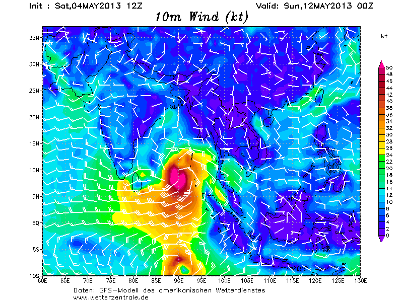
Even een gifje gemaakt. Kan dinsdag al een orkaan worden (tropische storm) Het blijft wel lange termijn, deze systemen veranderen vaak nog van koers.

Een aantal modellen onder elkaar. Ook het Europees model laat nu het systeem zien boven de Indische oceaan.

Ja, 1 juni gaat het seizoen officieel van start.quote:
[..]
seizoen begint binnenkort. Het is nu al onrustig in de golf.
Afwachten maar, wat het gaat worden
Heb zelf het vermoeden dat het wel eens een pittig seizoen kan gaan worden, met name van wege het uitblijven van El Nino.
De meeste voorspellingen gaan ook uit van een bovengemiddeld seizoen net als het afgelopen jaar het geval was.
We zullen het zien, een TD of TW vind ik schitterend maar liever niet het echte werk.

Deze 'forecasts' al gelezen?
http://www.weatherbell.com/2013-Hurricane-Season-Forecast
http://www.weather.com/ne(...)tlook-april-20130408
http://www.weatherbell.com/2013-Hurricane-Season-Forecast
http://www.weather.com/ne(...)tlook-april-20130408
Joe Bastardiquote:
Deze 'forecasts' al gelezen?
http://www.weatherbell.com/2013-Hurricane-Season-Forecast
http://www.weather.com/ne(...)tlook-april-20130408
Hij zat vorig jaar wel goed met Sandy... Gaat wat worden dit seizoen.
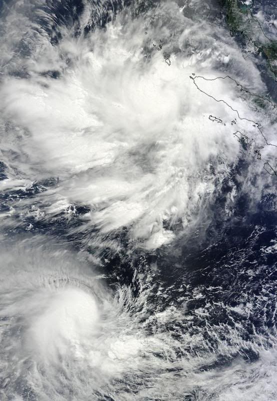
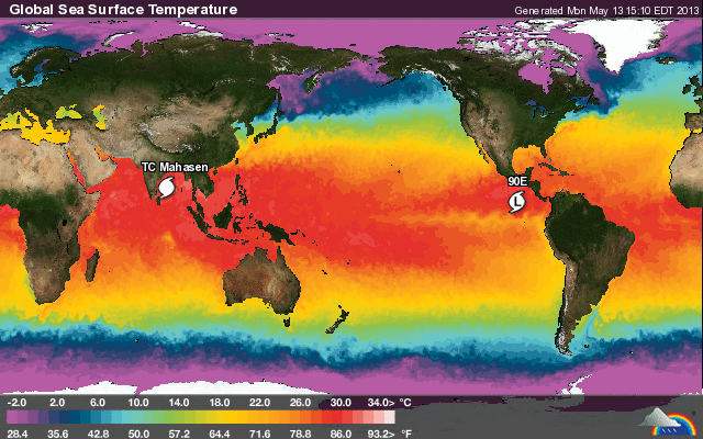
Double trouble: Tropical Cyclone Jamala (lower) and Tropical Cyclone Mahasen (upper storm) spin on opposite sides of the Equator in this in this MODIS image taken at 04:25 UTC May 10, 2013. Mahasen is the name of a King of Sri Lanka from the 3rd century. Image credit: NASA.
Ook de nieuwe run laat een systeem zien in het Caribisch gebied wat via Cuba en de golf van Mexico richting Florida trekt. Blijft wel de lange termijn.
quote:
Deze 'forecasts' al gelezen?
http://www.weatherbell.com/2013-Hurricane-Season-Forecast
http://www.weather.com/ne(...)tlook-april-20130408

Van TWUquote:MJO pulse that spawned Mahasen headed towards the Atlantic
Mahasen spun up in response to an active phase of the Madden Julian Oscillation (MJO) that has been moving through the Indian Ocean during the past week. The MJO is a pattern of increased thunderstorm activity near the Equator that moves around the globe in 30 - 60 days. The strong MJO pulse coincided with a convectively coupled atmospheric Kelvin wave (CCKW), a wave of increased heat and moisture propagating along the Equator, which helped increase thunderstorm activity. The active pulse of the Madden Julian Oscillation is expected to reach the Western Caribbean sometime May 22 - 26, and there will be a heightened chance of an early-season tropical storm forming in the Eastern Pacific and Western Caribbean during that time period.
There is a small disturbance a few hundred miles north of Puerto Rico today that has developed some spin and a bit of heavy thunderstorm activity. This system is over cool waters of 77 - 79°F, and will likely be torn apart by high wind shear on Sunday.
quote:Alvin coming? First "Invest" of the year forms in the Eastern Pacific
The official start of hurricane season in the Eastern Pacific is Wednesday, May 15, and it looks like Mother Nature is playing along with this idea, with the appearance yesterday of the year's first "Invest" (Invest 90E) in the Eastern Pacific. Invest 90E is moving west-northwest into the Central Pacific, and is not a threat to any land areas. Satellite loops show a modest area of disorganized heavy thunderstorms. Wind shear is a low 5 -10 knots, and is predicted to remain low for the next four days. Ocean temperatures are a warm 29 - 30°C, and I give a 30% chance that 90E will become a tropical depression by Thursday morning, as predicted by the GFS model. If the system reaches tropical storm strength, it would be called Alvin.
Jeff Masters


Ik heb vorig jaar de gehele ontwikkeling van Sandy gevolgd, Joe Bastardi was inderdaad vrij accuraat in zijn voorspellingen. Misschien is het een idee om de Twitter accounts van Joe Bastardi en Ryan Maue (ook van WeatherBell) in de OP te zetten.quote:
[..]
Joe BastardiDie zit toch bij Weatherbell?
Hij zat vorig jaar wel goed met Sandy... Gaat wat worden dit seizoen.
https://twitter.com/BigJoeBastardi
https://twitter.com/ryanmaue
Ik ook idd.quote:
[..]
Ik heb vorig jaar de gehele ontwikkeling van Sandy gevolgd, Joe Bastardi was inderdaad vrij accuraat in zijn voorspellingen. Misschien is het een idee om de Twitter accounts van Joe Bastardi en Ryan Maue (ook van WeatherBell) in de OP te zetten.
https://twitter.com/BigJoeBastardi
https://twitter.com/ryanmaue
Joe Bastardi is een held gewoon. Hij zag het goed met Sandy. Hij zat altijd bij accuweather. Heeft veel kennis over orkanen.
Is de 2e storm ook in aantocht voor de oost pacific? (Barbara).
[ Bericht 1% gewijzigd door #ANONIEM op 22-05-2013 02:53:37 ]
[ Bericht 1% gewijzigd door #ANONIEM op 22-05-2013 02:53:37 ]
NOAA predicts active 2013 Atlantic hurricane season
In its 2013 Atlantic hurricane season outlook issued today, NOAA’s Climate Prediction Center is forecasting an active or extremely active season this year.
For the six-month hurricane season, which begins June 1, NOAA’s Atlantic Hurricane Season Outlook says there is a 70 percent likelihood of 13 to 20 named storms (winds of 39 mph or higher), of which 7 to 11 could become hurricanes (winds of 74 mph or higher), including 3 to 6 major hurricanes (Category 3, 4 or 5; winds of 111 mph or higher).
These ranges are well above the seasonal average of 12 named storms, 6 hurricanes and 3 major hurricanes.
“With the devastation of Sandy fresh in our minds, and another active season predicted, everyone at NOAA is committed to providing life-saving forecasts in the face of these storms and ensuring that Americans are prepared and ready ahead of time.” said Kathryn Sullivan, Ph.D., NOAA acting administrator. “As we saw first-hand with Sandy, it’s important to remember that tropical storm and hurricane impacts are not limited to the coastline. Strong winds, torrential rain, flooding, and tornadoes often threaten inland areas far from where the storm first makes landfall.”
Three climate factors that strongly control Atlantic hurricane activity are expected to come together to produce an active or extremely active 2013 hurricane season. These are:
A continuation of the atmospheric climate pattern, which includes a strong west African monsoon, that is responsible for the ongoing era of high activity for Atlantic hurricanes that began in 1995;
Warmer-than-average water temperatures in the tropical Atlantic Ocean and Caribbean Sea; and
El Niño is not expected to develop and suppress hurricane formation.
“This year, oceanic and atmospheric conditions in the Atlantic basin are expected to produce more and stronger hurricanes,” said Gerry Bell, Ph.D., lead seasonal hurricane forecaster with NOAA’s Climate Prediction Center. “These conditions include weaker wind shear, warmer Atlantic waters and conducive winds patterns coming from Africa."
NOAA’s seasonal hurricane outlook is not a hurricane landfall forecast; it does not predict how many storms will hit land or where a storm will strike. Forecasts for individual storms and their impacts will be provided throughout the season by NOAA’s National Hurricane Center.
New for this hurricane season are improvements to forecast models, data gathering, and the National Hurricane Center communication procedure for post-tropical cyclones. In July, NOAA plans to bring online a new supercomputer that will run an upgraded Hurricane Weather Research and Forecasting (HWRF) model that provides significantly enhanced depiction of storm structure and improved storm intensity forecast guidance.
Also this year, Doppler radar data will be transmitted in real time from NOAA’s Hurricane Hunter aircraft. This will help forecasters better analyze rapidly evolving storm conditions, and these data could further improve the HWRF model forecasts by 10 to 15 percent.
The National Weather Service has also made changes to allow for hurricane warnings to remain in effect, or to be newly issued, for storms like Sandy that have become post-tropical. This flexibility allows forecasters to provide a continuous flow of forecast and warning information for evolving or continuing threats.
“The start of hurricane season is a reminder that our families, businesses and communities need to be ready for the next big storm,” said Joe Nimmich, FEMA associate administrator for Response and Recovery. “Preparedness today can make a big difference down the line, so update your family emergency plan and make sure your emergency kit is stocked. Learn more about how you can prepare for hurricane season at www.ready.gov/hurricanes.”;
Next week, May 26 - June 1, is National Hurricane Preparedness Week. To help those living in hurricane-prone areas prepare, NOAA is offering hurricane preparedness tips, along with video and audio public service announcements in both English and Spanish, featuring NOAA hurricane experts and the FEMA administrator at www.nhc.noaa.gov/prepare/.
NOAA’s outlook for the Eastern Pacific basin is for a below-normal hurricane season and the Central Pacific basin is also expected to have a below-normal season. NOAA will issue an updated outlook for the Atlantic hurricane season in early August, just prior to the historical peak of the season.
NOAA’s mission is to understand and predict changes in the Earth's environment, from the depths of the ocean to the surface of the sun, and to conserve and manage our coastal and marine resources. Join us on Facebook, Twitter and our other social media channels.
http://www.noaanews.noaa.(...).UZ5V6zmvpBw.twitter
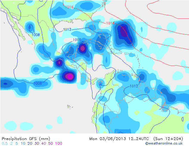
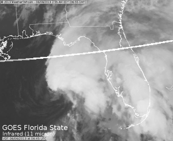
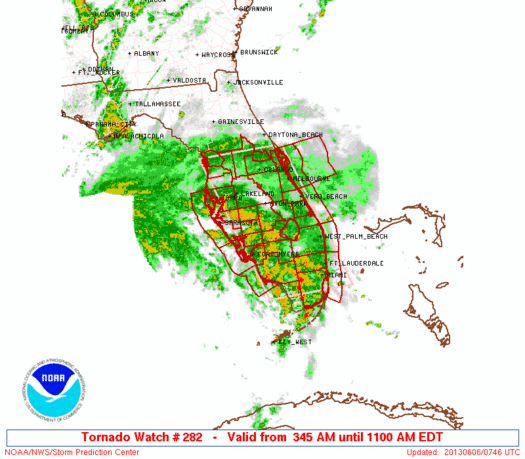
Lange termijn (begin juni) laat een systeem zien wat vanuit het Caribisch gebied de Golf van Mexico intrekt om daarna richting Florida te gaan. Vervolgens trekt deze over Florida heen, waarna de oostkust van de VS aan de beurt is.

GOES-13 is kapot 
quote:U.S. weather-watcher satellite fails just before hurricane season
CAPE CANAVERAL, Florida (Reuters) - A key satellite positioned to track severe weather in the eastern United States has failed, just as the 2013 Atlantic hurricane season is about to start.
The U.S. National Oceanic and Atmospheric Administration (NOAA) activated a spare satellite, which will provide coverage of the East Coast, while it is trying to fix the failed one, the agency said in a status report on its website on Friday.
"There is no estimate on return to operations at this time," NOAA said.
The Atlantic-Caribbean hurricane season starts on June 1 and lasts six months. NOAA expects this year's season to be "extremely active," with 13 to 20 tropical storms and seven to 11 of those strengthening into hurricanes.
The agency's three current Geostationary Operational Environmental Satellites, known as GOES, were built by Boeing and designed to last 10 years. The failed spacecraft, GOES-13, was launched in 2006.
NOAA typically operates two GOES spacecraft over the United States, overlooking the East and West coasts, plus one on-orbit spare. The satellites are outfitted with imagers to watch for clouds and developing storms, and atmospheric sounders to measure temperatures and humidity.
The first sign of trouble with GOES-13, the primary East Coast satellite, surfaced late Wednesday when it failed to relay expected images, NOAA status reports show.
GOES-13 is located over 75 degrees west longitude. Though activated, the spare remains in its storage orbit at 105 degrees west.
NOAA said it currently is not planning to drift the spare east, while efforts to troubleshoot its failed sister satellite are under way.
NOAA also has an older GOES-12 satellite, launched in 2001, parked at 60 degrees west that provides coverage of South America.
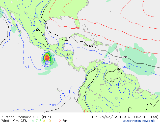
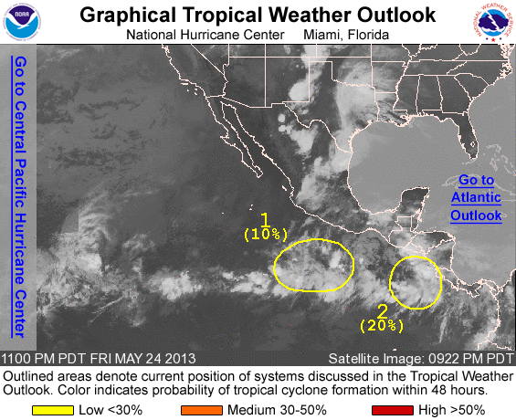
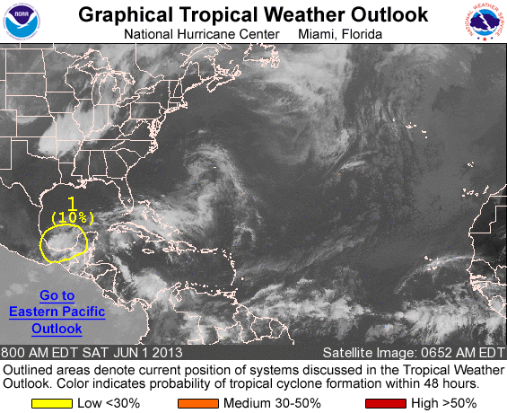
Zeer onrustig in meerdere tropische gebieden. De gevaarlijkste zitten nu bij Bangladesh en Mexico, maar ook voor de kust van Somalië is nu een invest te vinden. Ook in het caribisch gebied en de Golf van Mexico kan het over een tijdje raak zijn. GFS blijft komen met een systeem dat zich ten zuiden van Cuba ontwikkeld, waarna het de Golf induikt richting Florida.
Bangladesh
Mexico
Bangladesh
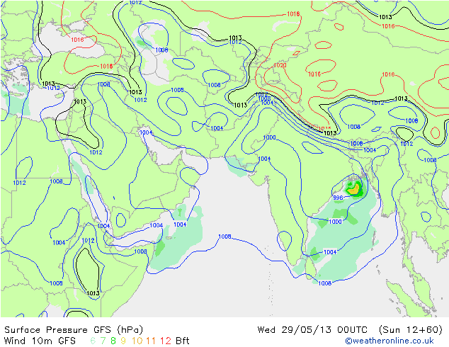
Mexico


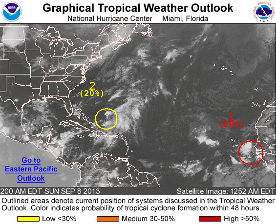
Nu 90%quote:
[ afbeelding ]
80% voor het gebied in de Oost-Pacific, lijkt de volgende tropische storm te worden
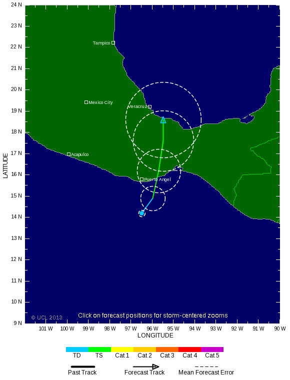


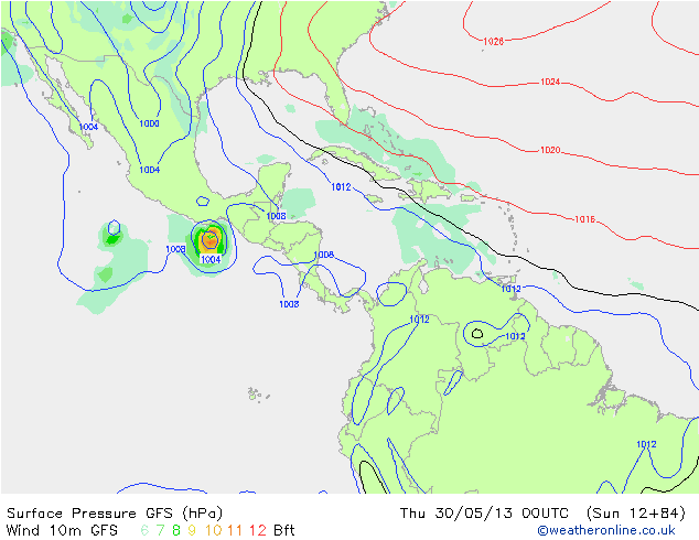
Barbara staat op het punt landfall te maken als een orkaan.
quote:Hurricane warnings are flying for the Pacific coast of Mexico, where Tropical Storm Barbara is rapidly intensifying as it makes landfall. Barbara should be ashore by 2 pm EDT (11 am PDT), and is expected to intensify to a Category 1 hurricane with 75 mph winds before landfall. Barbara formed on Tuesday night (May 28), an unusually early date for the formation of the Eastern Pacific's second storm of the year. The record earliest second storm of the year occurred just last year, on May 21 (Tropical Storm Bud.) The previous record was set in 1984, when the second named storm (Boris) formed on May 29. Reliable records of Eastern Pacific hurricanes go back to 1949. Barbara wasted no time getting organized, and is gathering strength in impressive fashion as it nears landfall in Mexico's Bay of Tehuantepec area. The storm's main threat is very heavy rains of up to a foot, which will be capable of causing dangerous flash floods and mudslides over the next 2 - 3 days. However, wind damage and the expected 3 - 5 foot storm surge are also a concern, since the area of the coast it is hitting, though not heavily populated, has very little hurricane experience. According to NOAA's Historical Hurricane Tracks website, only one Eastern Pacific hurricane has ever hit the Bay of Tehuantepec--Category 1 Hurricane Rick of 1997. Radar out of Puerto Angel, Mexico shows that Barbara has built a partial eyewall, and the storm has already spread heavy rains ashore along portions of the Mexican coast. Satellite loops show that Barbara is a relatively small storm, with a modest area of heavy thunderstorms.
quote:Orkaan Barbara maakt twee slachtoffers in Mexico
Heftige onweders in het zuiden van Mexico hebben gisteren twee mensenlevens gekost. Nabij de stad Salina Cruz, in de staat Oaxaca, verdronk een 51-jarige Amerikaanse surfer. In de stad Pinotepa Nacional werd een jonge man na een stortbui meegesleurd door het water en liet daarbij het leven. Dat hebben plaatselijke autoriteiten bekendgemaakt.
Kort voordien was orkaan Barbara in de buurstaat Chiapas aan land gekomen. De stortregens gingen gepaard met windsnelheden tot 150 kilometer per uur, aldus de weerkundige dienst.
Meerdere plaatsen langs de kust werden ontruimd voor het naderende stormweer. In zes dorpen werden de bewoners in veiligheid gebracht.
Barbara is de eerste orkaan van het nieuwe seizoen dat op 15 mei is begonnen. Weerkundigen rekenen tot eind november op nog minstens zeven orkanen in het gebied.

Ik heb het nog even nagekeken en het zijn inderdaad gewoon de restanten van Barbara. Maar het systeem gaat wel gewoon een andere naam krijgen, omdat de storm geen TS of TD meer was na de oversteek over Mexico. Dit kan dus de eerste storm met een naam worden in de Atlantische oceaan.
De eerste naam is overigens "Andrea".
De eerste naam is overigens "Andrea".
Ehh, ~300 mmquote:
'very heavy rains of up to a foot'
Dat is 3000 mm...
Nu 40% in de Golf. De meeste neerslag zit aan de oostkant van het systeem. Het lijkt erop dat dit tropische gebied vooral voor veel neerslag zal gaan zorgen in Florida en mogelijk de oostkust van de VS.


GFS liet het al vroeg zien. Deze post is van 12 mei. 
quote:
Ook de nieuwe run laat een systeem zien in het Caribisch gebied wat via Cuba en de golf van Mexico richting Florida trekt. Blijft wel de lange termijn.
[ afbeelding ]


De 2e storm alweer met een naam. Gaat nog voor flink wat neerslag zorgen in Mexico,quote:
Invest is toch nog opgewaardeerd naar Tropical Storm Barry


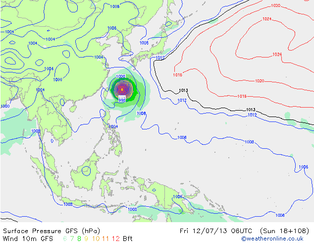
SOULIK in de west pacific is nu een cat 1, maar gaat nog verder toenemen in kracht tot misschien meer dan cat 3. Systeem trekt in de richting van Taiwan en China.

Gaat spannend worden wat SOULIK gaat doen. GFS laat het systeem meer ten noorden van Taiwan passeren, waardoor het zwaarste windveld het eiland gaat missen. CMC en ECMWF laten de cycloon landfall maken op Taiwan, met alle gevolgen van dien.
Taiwan krijgt in ieder geval te maken met deze cycloon.
De verwachting van TSR is dat het een categorie 4 gaat worden en aan de noordkant langs Taiwan trekt.
Taiwan krijgt in ieder geval te maken met deze cycloon.
De verwachting van TSR is dat het een categorie 4 gaat worden en aan de noordkant langs Taiwan trekt.


Ze gaan weer harde woeien krijgen
Kijk alweer uit naar live verslagen
Kijk alweer uit naar live verslagen
Doe mee met het voorspellen van het weer!
Weekvoorspelling | Week 12 (invullen tot 16-03 - 11:59)
Maandvoorspelling Maart (Inzendingen gesloten)
Jaarvoorspelling 2025 / 2026
Weekvoorspelling | Week 12 (invullen tot 16-03 - 11:59)
Maandvoorspelling Maart (Inzendingen gesloten)
Jaarvoorspelling 2025 / 2026
Tja of je er blij mee moet zijn?quote:
Ze gaan weer harde woeien krijgen
Kijk alweer uit naar live verslagen
Zeker als het cat 4 wordt en blijft en dan vol Taiwan treft
Natuurlijk zijn de gevolgen niet leuk, maar als weer gek kick je er ook weer op.quote:
[..]
Tja of je er blij mee moet zijn?
Zeker als het cat 4 wordt en blijft en dan vol Taiwan treft
Zie het als een Tornado, als die de grond raakt en Reed Timmer passeert wordt hij helemaal gek, gewoon die kick en het hebben van de video's en data
Als ze daarna zien wat voor schade die verder op gaat aanrichten slaat de stemming uiteraard volledig om, toch zul je en blijf je toch de kick reactie houden ongeacht wat er allemaal gebeurd.
Doe mee met het voorspellen van het weer!
Weekvoorspelling | Week 12 (invullen tot 16-03 - 11:59)
Maandvoorspelling Maart (Inzendingen gesloten)
Jaarvoorspelling 2025 / 2026
Weekvoorspelling | Week 12 (invullen tot 16-03 - 11:59)
Maandvoorspelling Maart (Inzendingen gesloten)
Jaarvoorspelling 2025 / 2026
Heb ik zelf ook hoor. Ik vind het fantastisch mooi om die beelden te zien.quote:
Natuurlijk zijn de gevolgen niet leuk, maar als weer gek kick je er ook weer op.
Zie het als een Tornado, als die de grond raakt en Reed Timmer passeert wordt hij helemaal gek, gewoon die kick en het hebben van de video's en data
Als ze daarna zien wat voor schade die verder op gaat aanrichten slaat de stemming uiteraard volledig om, toch zul je en blijf je toch de kick reactie houden ongeacht wat er allemaal gebeurd.
Maar ja als dan mogelijk een cat 4 op zo'n land afgaat tja dan gaat het niet goed komen.

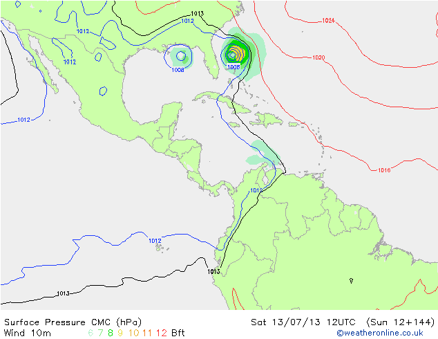
Chantal kan voor overlast gaan zorgen. In Puerto Rico, de Dominicaanse Republiek en Haïti staan nu waarschuwingen uit voor een tropische storm.

Ik kan vrijdag voor beeldmateriaal zorgen van chantal, ik zit nu in miami
hier schreef kensei: haha komen
hier schreef UnicornFarts: Ik weet dat SV heet is, Grielen heet is, maar van jou heb ik nog geen bewijs.
hier schreef UnicornFarts: Ik weet dat SV heet is, Grielen heet is, maar van jou heb ik nog geen bewijs.
Als het dan nog wat is, lijkt nu meer een regenevenement te worden.quote:
Ik kan vrijdag voor beeldmateriaal zorgen van chantal, ik zit nu in miami
Maar foto's zijn altijd welkom
Schepen veilig langs orkanen routeren
Diverse tropische stormen en orkanen trekken weer over de Grote Oceaan en Atlantische Oceaan, zo lang ze op zee blijven hebben de meeste mensen geen last van deze stormen. Maar hoe zit dat nou als je aan boord van een schip zit en in de buurt van een orkaan komt?
In de maand mei is er al wat over het huidige orkaan seizoen geschreven, wat de verwachtingen voor komend seizoen zijn, over het ontstaan van orkanen, maar ook hoe men zich hier aan land op kan voorbereiden.
Vandaag willen we de orkanen eens van een ander hoek benaderen. Hoe doen schepen dat nou? Wat als je onderweg bent en een orkaan lijkt je route te kruisen of wat doe je als je in de haven ligt te laden of te lossen?
Een groot onderdeel van MeteoConsult houdt zich bezig met allerlei weersverwachtingen binnen de nautische wereld. Bij Routeguard zit een team van meteorologen, oud kapiteins en stuurlieden die diverse schepen routeren. Hierbij wordt op basis van het weer en de nautische regels de beste route voor een schip gemaakt.
De afgelopen dagen waren er twee tropische stormen en een orkaan actief. Tropische Storm Erick op het oostelijk gedeelte van de Grote Oceaan trok langs de Mexicaanse kust omhoog. Chantal, ook een tropische storm heeft ondertussen de Dominicaanse republiek bereikt. Orkaan Soulik is actief over de Filippijnse Zee (westelijk gedeelte van de Grote Oceaan) en zal de komende tijd nog in kracht toenemen.
Deze weerssystemen hebben er voor gezorgd dat een aantal schepen moesten omvaren of blijven wachten, om deze stormen op veilige afstand te laten passeren.
Aan de hand van een schip dat op dit moment door ons gerouteerd wordt, willen we laten zien, voor wat voor een situaties de kapitein komt te staan.
Dit schip is gisteren vanuit een haven net boven Sjanghai vertrokken en gaat richting Australië. Als het schip direct naar Australië zou varen, dan zou orkaan Soulik met gemiddelde windsnelheden van 130knopen (windkracht 12) over het schip razen, gepaard gaande met golven tot wel 13 meter.
Om dit te vermijden zal het schip op een afstand van bijna 400 nautische mijl (wat zo’n 740 kilometer is), 24 uur wachten om de orkaan voor lang te laten passeren.
Het gevaar bij orkanen is dat ze altijd af kunnen wijken het verwachte pad. In het geval van eerder genoemd schip zou het gevaarlijk zijn als de orkaan meer naar het noorden afbuigt en alsnog richting het schip trekt.
Ook hier is rekening meegehouden in het route advies, mocht dit gebeuren, dan kan het schip haar koers aanpassen en in dit geval naar het oosten wegvaren.
In de haven blijven is ook geen optie als een orkaan overtrekt, daarom worden door de havenautoriteiten ook diverse maatregelen getroffen. Schepen die aan het laden of lossen zijn moeten deze werkzaamheden staken en het ruime sop kiezen. Want aan de kade blijven liggen is geen optie met zulke windsnelheden, trossen worden dan gewoon losgerukt.
Bovenstaand geeft aan hoe belangrijk het voor schepen is om altijd goed op de hoogte van de weerssituatie te zijn en op tijd eventuele maatregelen te nemen. Daarom zijn wij bij MeteoConsult 24 uur per dag bezig met het verstrekken van weersverwachtingen en route adviezen aan allerlei schepen.
Bron: MeteoConsult, NOAA, National Hurricane Centre
Southeast U.S. vulnerable to flooding
If Chantal or its remnants brings heavy rains to the Southeast U.S. early next week, as some of the current track models are predicting, the storm could cause major damaging flooding. The soils in the Southeast are saturated and many rivers are already in flood, due to last week's extreme jet stream pattern that set up a fire hose of tropical moisture that streamed inland from the Florida Panhandle through Georgia, South Carolina, and North Carolina. Soils over large areas of the Southeast U.S. are near the wettest levels ever observed for this time of year--above the 99th percentile in recorded history. It's remarkable that most of Georgia, South Carolina, and North Carolina were in moderate or greater drought at the beginning of the year. Portions of Central Georgia were in exceptional drought--the most extreme category of drought.
bron

Nou dat was niet zo heel spectaculair, een flinke stortbui en wat onweer gistermiddag rond 1 uur.quote:
[..]
Als het dan nog wat is, lijkt nu meer een regenevenement te worden.
Maar foto's zijn altijd welkom


Maar dit was Chantal zelf niet, meer een depressie die aan Chantal gelinkt werd. Het kan zijn dat in de loop van de dag het weer slechter wordt, maar op het moment is het heerlijk zonnig
hier schreef kensei: haha komen
hier schreef UnicornFarts: Ik weet dat SV heet is, Grielen heet is, maar van jou heb ik nog geen bewijs.
hier schreef UnicornFarts: Ik weet dat SV heet is, Grielen heet is, maar van jou heb ik nog geen bewijs.


TS Dorian is a fact.
Hopelijk blijft het bij een TS'je.....
http://www.accuweather.com/en/hurricane/atlantic
Hopelijk blijft het bij een TS'je.....
http://www.accuweather.com/en/hurricane/atlantic
En opeens staat daar ook weer een nieuwe invest (99L)
Voorteken van een actief oorkaanseizoen dit jaar?
Voorteken van een actief oorkaanseizoen dit jaar?


Dorian is een feit inmiddels... tot na het weekend als TS verder... dan ben ik benieuwd wat het pad gaat worden
GFS zet de landfall nu op Zuid Florida, waarna hij een klein stukje van de GOM meepakt om vervolgens N-W Florida in te trekken.


Supercomputers helpen VS in orkaanseizoen
De Amerikaanse meteorologische dienst NOAA heeft de snelheid van twee supercomputers verdubbeld om betere voorspellingen te kunnen doen tijdens het verwachte zware orkaanseizoen.
Dat meldt NOAA maandagnacht (Nederlandse tijd).
De supercomputers kunnen nu 213 biljoen berekeningen per seconden maken vanwege hun rekenkracht van 213 teraflops (TF). Dat is een forse verbetering vergeleken met de 90 teraflops van de vorige generatie supercomputers bij de weerdienst.
Daarmee zijn de computers nog steeds een stuk minder krachtig dan de snelste supercomputer ter wereld. Deze Chinese variant haalt een snelheid van omgerekend 33860 teraflops.
De extra kracht is volgens NOAA voor nu voldoende om beter te kunnen voorspellen waar en wanneer orkanen aan land komen. Ook is het precies volgen van de huidige activiteit van een orkaan mogelijk. De supercomputers maken hiervoor gebruik van een nieuw weermodel.
De upgrade lijkt op een goed moment te komen nu meteorologen een extra zwaar orkaanseizoen verwachten. Het seizoen loopt van 1 juni tot en met 30 november en door verschillende bureaus worden zes tot tien orkanen voorspeld. Zes is het gemiddelde per seizoen.
15 procent
De Amerikaanse meteorologische dienst heeft twee supercomputers. Tide staat in Reston, Virginia en Gyre in Orlando, Florida. Het nieuwe weermodel waarmee de computers werken moet de prestaties en voorspellingen met 15 procent verbeteren in vergelijking met vorig jaar.
Ook kunnen de supercomputers real-time data verwerken van speciale vliegtuigen van NOAA die gegevens meten in het oog van een orkaan. Met deze data kunnen voorspellingen nog nauwkeuriger worden. In 2015 wordt een nieuwe update aan de computers verwacht waardoor de rekenkracht uit moet komen op 1950 petaflops.
Bron: http://www.nu.nl/tech/353(...)n-orkaanseizoen.html
You better lose yourself in the music
The moment, you own it, you better never let it go
The moment, you own it, you better never let it go

Saharazand is toch funest voor de ontwikkeling van orkanen?quote:Op maandag 5 augustus 2013 15:11 schreef Leeward het volgende:
Met dank aan de Sahara
http://www.theworld.org/2(...)ows-across-atlantic/
Zeker weten. Ik zie voorlopig ook nog geen orkaan ontstaan boven de atlantic.quote:
[..]
Saharazand is toch funest voor de ontwikkeling van orkanen?
Het is al wel augustus, mag onderhand wel op gang gaan komen.
Meende vorige week ergens te lezen dat ze het vanaf tweede/derde week in gang zien komen...quote:
[..]
Zeker weten. Ik zie voorlopig ook nog geen orkaan ontstaan boven de atlantic.
Het is al wel augustus, mag onderhand wel op gang gaan komen.
Maar goed, afwachten maar
Haha, ja dat klopt, het fenomeen is erg interessant en van een afstand ook erg mooi, maar ik zit even niet op een Cat.2 of hoger te wachtenquote:
[..]
Saharazand is toch funest voor de ontwikkeling van orkanen?


De storm in de west pacific heeft de naam UTOR gekregen en trekt richting de Filipijnen. TSR laat de tyfoon nu over het noordelijke deel van de Filipijnen trekken en daarna richting China en Vietnam.


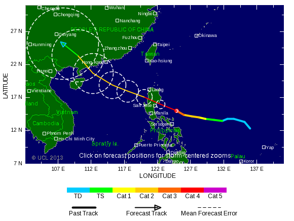

http://www.euronews.com/2(...)kes-the-philippines/quote:The most powerful typhoon to hit the Philippines this year has triggered floods and landslides, smashed hundreds of homes and disrupted power and communication links.
Typhoon Utor, packing winds of 150 kilometres per hour near its centre and gusts of up to 185 kph, made landfall on the northern island of Luzon.
The national disaster agency said a man clearing a clogged drain was killed when a landslide buried him in mountainous Benguet province and dozens of people – mostly fishermen – are missing.
The typhoon has also badly damaged rice, corn and coconut crops.
The coastal town of Casiguran in Aurora province, 343 kilometres northeast of the capital Manila, suffered the worst damage, after the typhoon set off landslides that blocked its only access road.
“About 90 percent of our agriculture was destroyed or damaged,” Aurora governor Gerardo Noveras told ANC television, adding that the full extent of damage was still unknown.
Losing strength the typhoon moved out over the South China Sea and was expected to hit about 300 kilometres southwest of Hong Kong.
On average 20 typhoons hit the Philippines every year.
http://newsinfo.inquirer.(...)ssing-in-philippinesquote:MANILA, Philippines—A powerful typhoon battered the northern Philippines on Monday, toppling power lines and dumping heavy rain across cities and food-growing plains. The storm left at least two people dead and 44 missing.
Typhoon Utor (local name: Labuyo), described as the strongest globally this year, slammed ashore in mountainous eastern Aurora province with sustained winds of 175 kilometers (109 miles) per hour and gusts of up to 210 kph (130 mph).
Footage from ABS-CBN TV network showed a woman swept away by a raging river in neighboring Isabela province. The woman waved her hands for help as she struggled to hang on to debris while being buffeted by huge waves in the muddy waters. It was not known what happened to her.
“She has not been found, so she is missing,” said Norma Talosig, a regional civil defense director. She said the woman lived alone in a low-lying area and had refused to be evacuated.
Talosig said that in northern Nueva Vizcaya province, a 53-year-old farmer drowned while trying to rescue his water buffalo from a swift-moving flood. The animal survived.
In mountainous Benguet province, a 22-year-old man died on the way to a hospital after he was pulled from a landslide that hit a canal he was clearing, said regional civil defense official Andrew Alex Uy.
8-foot waves
The typhoon triggered waves of up to 2.5 meters (eight feet) and left scores of fishermen missing.
In northern Pangasinan province, 25 fishermen on three boats failed to return home, said provincial police spokesman Senior Inspector Ryan Manongdo.
Eighteen other fishermen from the eastern provinces of Catanduanes and Camarines Norte also were unaccounted for. Authorities were hoping they took shelter in coves and nearby islands, said Office of Civil Defense regional director Bernardo Alejandro IV.
“I hope they’re just waiting for the typhoon to pass and will show up as soon as the weather clears,” he said. A higher number of missing had been reported earlier, but some of the fishermen have returned home.
As of late Monday, Utor picked up speed as it continued to move away from the country. Government forecaster Joey Figuracion said the typhoon was 230 kilometers (140 miles) northwest of northern Ilocos Sur province’s coast, and moving to the northwest.
It was forecast to reach southern China on Wednesday.
Office of Civil Defense Administrator Eduardo del Rosario said 1,895 people from three regions had to be evacuated to shelters, with 673 houses damaged.
Utor, the Marshellese word for a squall line, was the 12th of about 20 storms and typhoons expected to lash the Philippines this year.—Teresa Cerojano with Joeal Calupitan, Hrvoje Hranjski and Jim Gomez

Het is nu alweer een cat 3 en gaat weer een cat 4 worden. Nu is China aan de beurt.quote:
[..]
Landfall cat.4...
dan denk je: Big Trouble...

[ Bericht 8% gewijzigd door #ANONIEM op 13-08-2013 07:27:51 ]
Vier doden en 36.000 ontheemden na doortocht tyfoon Utor op Filipijnen
Op de Filipijnen zijn na de doortocht van tyfoon Utor vier doden geteld. Meer dan 36.000 Filipino's moesten hun woonst verlaten, zo liet de civiele bescherming weten.
Met rukwinden tot 160 kilometer per uur (en uitschieters van zelfs 195 km/u) was de wervelstorm ongemeen krachtig. Elf mensen, onder wie negen vissers, zijn nog vermist. De totale schade die Utor op de Filipijnen heeft aangericht, wordt geschat op 1,2 miljoen euro.
De tyfoon is nu onderweg naar Zuidoost-China.
http://www.hln.be/hln/nl/(...)-op-Filipijnen.dhtml
Canadese model komt met een groot systeem voor de kust van Texas.
Het lijkt er op dat het op langere termijn drukker gaat worden boven de atlantische oceaan.
Het lijkt er op dat het op langere termijn drukker gaat worden boven de atlantische oceaan.


Intensiteit lijkt per run ook toe te nemen. Landfall schuift langzaam aan westelijker, nu dus op NW van de GOM (texas/mexico) waar het gisteren meer N van de GOM (new orleans) was.

Nu al een groot deel van de Caribische zee gevuld met onweersbuien. Dit gebied trekt de Golf van Mexico binnen. De vraag blijft waar het heen gaat. GFS zegt meer richting Florida en CMC gaat voor Mexico/Texas.


Wat gaat dit worden? Systeem duikt via Mexico de Golf van Mexico in en daarna richting de staat Louisiana..

Ziet er op de SSD in ieder geval een stuk beter als vanochtend. Het is afwachten wat het systeem gaat doen zodra hij over de Yucatan komt.
Dat is afwachten.. Geen model die duidelijkheid geeft.quote:
Ziet er op de SSD in ieder geval een stuk beter als vanochtend. Het is afwachten wat het systeem gaat doen zodra hij over de Yucatan komt.
Ziet er nu wel indrukwekkend uit.


"Light thinks it travels faster than anything. It doesn't. For wherever light travels it finds darkness has got there first and is waiting for it."
Inderdaadquote:
Mag hier trouwens ook wel bij in, thx alvast
WKN / Vier doden door tyfoon Utor
Update
Tropische storm Erin een feit... nu wachten op dat gebied bij de Golf.. lijkt kwestie van tijd voordat we daar TS Fernand zien
Tropische storm Erin een feit... nu wachten op dat gebied bij de Golf.. lijkt kwestie van tijd voordat we daar TS Fernand zien

Gebied is afgenomen tot 50% mogelijk dat het tot ontwikkeling komt in de golf. Nog onzeker wat er gaat gebeuren.


Ziet er niet echt indrukwekkend uit allemaal.
Lijkt eind augustus/begin september wat serieuzer te gaan worden.
Afwachten maar. Kan soms snel gaan. http://www.weather.com/ne(...)on-humberto-20130814
Lijkt eind augustus/begin september wat serieuzer te gaan worden.
Afwachten maar. Kan soms snel gaan.

WKN / Zware regens in Taiwan door tropische storm
Het noorden van Taiwan is woensdag getroffen door een zware tropische storm, Trami. De hevige regenval die daarmee gepaard ging heeft onder meer aardverschuivingen veroorzaakt. Scholen en kantoren in het dichtbevolkte gebied zijn gesloten. Voor zover bekend is er slechts een enkele gewonde gevallen.
Trami kwam rond 17.30 uur lokale tijd aan bij de kust van het eiland, op zo'n honderd kilometer van de hoofdstad Taipei. Voor zonsondergang was er in Taipei al meer dan dertig centimeter regen gevallen en in de bergen in het noordwesten van het land viel zelfs vijftig centimeter. Er werden constante windsnelheden van 108 kilometer per uur gemeten, met windstoten tot 137 kilometer per uur.
Trami trekt waarschijnlijk in de loop van de avond naar het westen, richting de Chinese provincie Fujian.
De tropische storm zorgde eerder deze week al voor ravage in de Filipijnen. Meer dan de helft van de hoofdstad Manilla kwam onder water te staan en ook de omliggende gebieden stonden grotendeels blank. Vijftien mensen kwamen om en 41 raakten gewond.
[ Bericht 82% gewijzigd door #ANONIEM op 21-08-2013 13:56:44 ]
Lijkt nu wat te gaan komen begin september. Volgende week onstaat er een systeem halverwege de atlantische oceaan wat richting de bovenwindse eilanden en Florida/Golf van Mexico trekt.

70% nu voor dat gebied in de Golfquote:
Het systeem bij Yucatan lijkt ook meer en meer potentie te hebben.


13 doden bij grondverschuiving in Mexico
In de Mexicaanse deelstaat Veracruz zijn minstens dertien mensen omgekomen bij een grondverschuiving, melden de hulpdiensten. Die was veroorzaakt door de hevige regenval die gepaard ging met de doortocht van de tropische storm Fernand.
In Yecuatla vielen negen doden te betreuren, in Tuxpan drie en in Atzalan een. Hoewel het intussen minder is gaan regenen, blijft de noodtoestand van kracht.
Na de doortocht van Fernand lieten de autoriteiten van Veracruz in een voorlopige balans weten dat 109 woningen schade opliepen. Ook moesten bijna 300 personen worden geëvacueerd.
bron


http://www.wired.com/wiredscience/2013/08/hurricane-tracks/
[ Bericht 48% gewijzigd door #ANONIEM op 27-08-2013 19:35:31 ]
quote:
[ afbeelding ]
http://www.wired.com/wiredscience/2013/08/hurricane-tracks/

Landslides als gevolg van TS Kong-Rey in Taiwan.
Let op de witte auto die voor de filmende auto rijdt
Als je goed kijkt zie je op 0.02/0.03 de rots afbreken van de berg, bovenaan in beeld.
[ Bericht 16% gewijzigd door YazooW op 31-08-2013 23:04:20 ]
Let op de witte auto die voor de filmende auto rijdt

Als je goed kijkt zie je op 0.02/0.03 de rots afbreken van de berg, bovenaan in beeld.
[ Bericht 16% gewijzigd door YazooW op 31-08-2013 23:04:20 ]
Die heeft gelukquote:
Landslides als gevolg van TS Kong-Rey in Taiwan.
Let op de witte auto die voor de filmende auto rijdt
Als je goed kijkt zie je op 0.02/0.03 de rots afbreken van de berg, bovenaan in beeld.

Het is nog afwachten wat dit gaat worden. Het Canadese model laat wel ontwikkeling zien inderdaad. Echt overtuigend is het nog steeds niet.


30% nu. Kan richting Bermuda gaan.quote:
97L begint er steeds beter uit te zien

[ Bericht 0% gewijzigd door #ANONIEM op 04-09-2013 02:08:43 ]
97L is nu TD Seven
[ Bericht 4% gewijzigd door YazooW op 04-09-2013 23:45:51 ]
Goed te volgen via deze radar: http://radar.weather.gov/(...)ay=11101111&loop=yesquote:000
WTNT32 KNHC 042057
TCPAT2
BULLETIN
TROPICAL DEPRESSION SEVEN ADVISORY NUMBER 1
NWS NATIONAL HURRICANE CENTER MIAMI FL AL072013
500 PM AST WED SEP 04 2013
...TROPICAL DEPRESSION FORMS SOUTH OF PUERTO RICO...
...TROPICAL STORM WARNINGS ISSUED...
SUMMARY OF 500 PM AST...2100 UTC...INFORMATION
----------------------------------------------
LOCATION...16.5N 66.2W
ABOUT 130 MI...210 KM S OF SAN JUAN PUERTO RICO
ABOUT 205 MI...330 KM SE OF PUNTA CANA DOMINICAN REPUBLIC
MAXIMUM SUSTAINED WINDS...35 MPH...55 KM/H
PRESENT MOVEMENT...NW OR 305 DEGREES AT 9 MPH...15 KM/H
MINIMUM CENTRAL PRESSURE...1009 MB...29.80 INCHES


[ Bericht 4% gewijzigd door YazooW op 04-09-2013 23:45:51 ]
twitter:BigJoeBastardi twitterde op woensdag 04-09-2013 om 23:33:28 Not on board yet with the recurve on its merry way idea on 7. Could stall in the Bahamas for a few days, waiting for eastern trough to leave reageer retweet
 Not on board yet with the recurve on its merry way idea on 7. Could stall in the Bahamas for a few days, waiting for eastern trough to leave
 twitter:BigJoeBastardi twitterde op woensdag 04-09-2013 om 23:36:18 Tho much less a storm now, lets recall the day 5 forecasts on Jeanne in 2004.GFS feedback can cause model problems reageer retweet