WKN Weer, Klimaat en Natuurrampen
Lees alles over het onstuimige weer op onze planeet, volg orkanen en tornado's, zie hoe vulkanen uitbarsten en hoe Moeder Aarde beeft bij een aardbeving. Alles over de verwoestende kracht van onze planeet en tal van andere natuurverschijnselen.


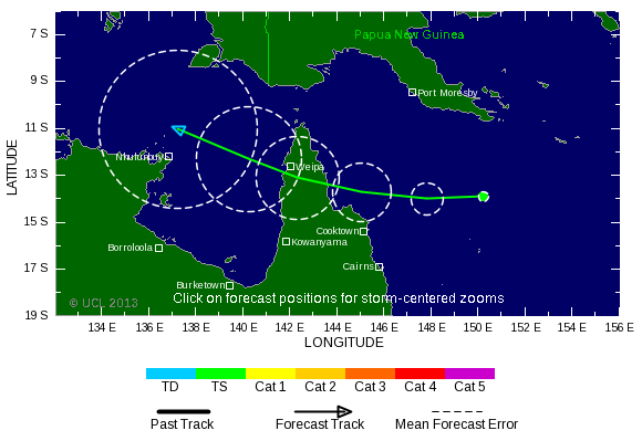


Aan het eind van het seizoen nog even een categorie 2 voor het oosten van Australië. Ik lees op een site dat ze blij zullen zijn met de neerslag, maar vraag me af of dat ook daadwerkelijk zo zal zijn.
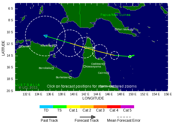
Voorspelling is alweer veranderd. Lijkt erop dat het nog een cat 1 gaat worden, voordat deze orkaan landfall gaat maken ergens in het uiterste noorden van Queensland.

Cat.1 misschien net niet maar kan maar zo dat de storm verderop nog eens aan land komt.quote:Op woensdag 1 mei 2013 10:09 schreef aloa het volgende:
Voorspelling is alweer veranderd. Lijkt erop dat het nog een cat 1 gaat worden, voordat deze orkaan landfall gaat maken ergens in het uiterste noorden van Queensland.
Kan zo maar inderdaad. Hij trekt niet lang over land en komt dan in de Golf van Carpentaria terecht. Temperatuur van het water ligt daar rond de 30 graden.quote:Op woensdag 1 mei 2013 11:52 schreef Frutsel het volgende:
[..]
Cat.1 misschien net niet maar kan maar zo dat de storm verderop nog eens aan land komt.
Hallo, heb ook even een user aangemaakt vanwege dit topic.
Woon zelf in de Caribbean en vind het leuk om de bevindingen van anderen over dit onderwerp te lezen.
Verder vind ik het 'weer' ook erg interessant.
Hopelijk wordt het een mooi seizoen zonder echte ellende.
Woon zelf in de Caribbean en vind het leuk om de bevindingen van anderen over dit onderwerp te lezen.
Verder vind ik het 'weer' ook erg interessant.
Hopelijk wordt het een mooi seizoen zonder echte ellende.

Welkomquote:
Hallo, heb ook even een user aangemaakt vanwege dit topic.
Woon zelf in de Caribbean en vind het leuk om de bevindingen van anderen over dit onderwerp te lezen.
Verder vind ik het 'weer' ook erg interessant.
Hopelijk wordt het een mooi seizoen zonder echte ellende.
Altijd handig, live weather reports vanuit het Hurricane Gebied

Bedankt!quote:Op vrijdag 3 mei 2013 21:42 schreef Frutsel het volgende:
[..]
Welkom
Altijd handig, live weather reports vanuit het Hurricane Gebied
Zal m'n best doen mocht het zover komen
seizoen begint binnenkort. Het is nu al onrustig in de golf.quote:Op vrijdag 3 mei 2013 21:44 schreef Leeward het volgende:
[..]
Bedankt!
Zal m'n best doen mocht het zover komen
Afwachten maar, wat het gaat worden
Gaat er wat komen boven de Indische oceaan. Dit Ziet er uit als een monster orkaan. Kan de kant van Sri lanka opgaan, al weet je het nooit in deze gebieden.

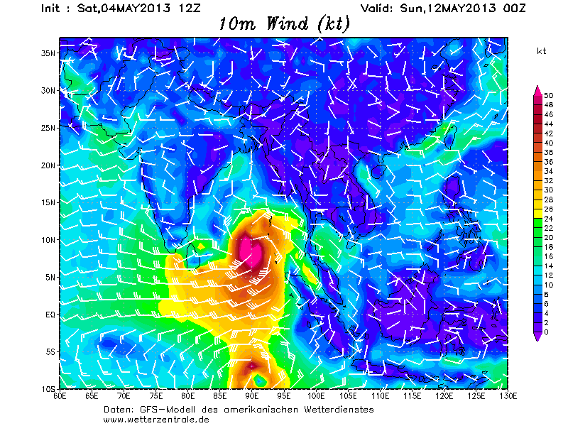
Even een gifje gemaakt. Kan dinsdag al een orkaan worden (tropische storm) Het blijft wel lange termijn, deze systemen veranderen vaak nog van koers.

Een aantal modellen onder elkaar. Ook het Europees model laat nu het systeem zien boven de Indische oceaan.

Ja, 1 juni gaat het seizoen officieel van start.quote:
[..]
seizoen begint binnenkort. Het is nu al onrustig in de golf.
Afwachten maar, wat het gaat worden
Heb zelf het vermoeden dat het wel eens een pittig seizoen kan gaan worden, met name van wege het uitblijven van El Nino.
De meeste voorspellingen gaan ook uit van een bovengemiddeld seizoen net als het afgelopen jaar het geval was.
We zullen het zien, een TD of TW vind ik schitterend maar liever niet het echte werk.

Deze 'forecasts' al gelezen?
http://www.weatherbell.com/2013-Hurricane-Season-Forecast
http://www.weather.com/ne(...)tlook-april-20130408
http://www.weatherbell.com/2013-Hurricane-Season-Forecast
http://www.weather.com/ne(...)tlook-april-20130408
Joe Bastardiquote:
Deze 'forecasts' al gelezen?
http://www.weatherbell.com/2013-Hurricane-Season-Forecast
http://www.weather.com/ne(...)tlook-april-20130408
Hij zat vorig jaar wel goed met Sandy... Gaat wat worden dit seizoen.
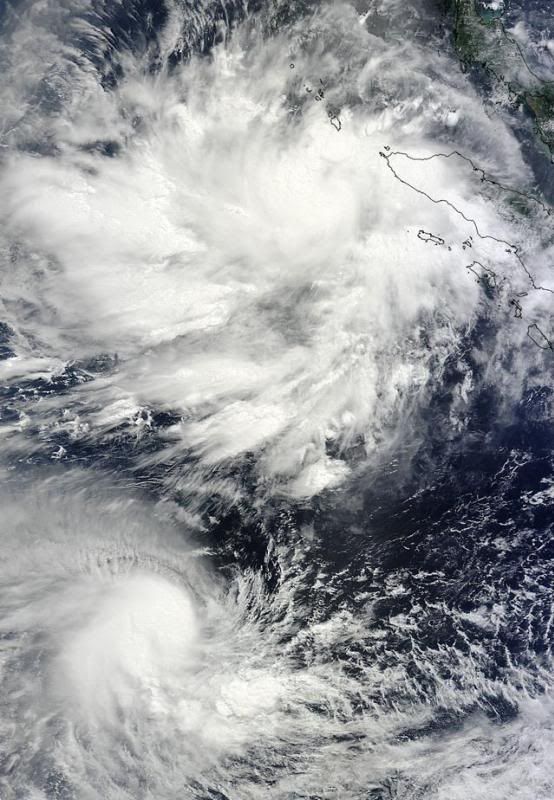
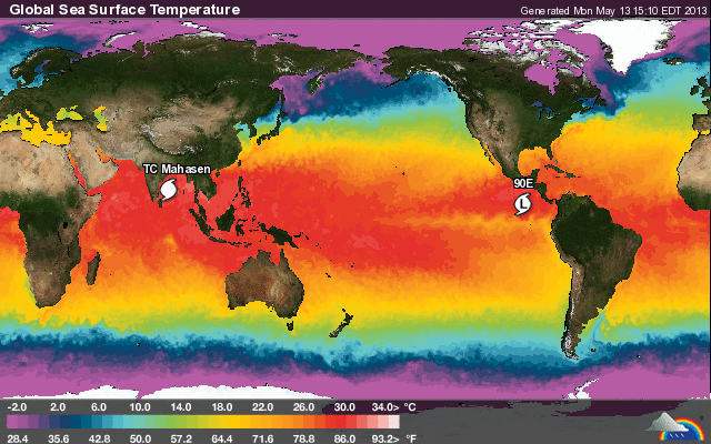
Double trouble: Tropical Cyclone Jamala (lower) and Tropical Cyclone Mahasen (upper storm) spin on opposite sides of the Equator in this in this MODIS image taken at 04:25 UTC May 10, 2013. Mahasen is the name of a King of Sri Lanka from the 3rd century. Image credit: NASA.
Ook de nieuwe run laat een systeem zien in het Caribisch gebied wat via Cuba en de golf van Mexico richting Florida trekt. Blijft wel de lange termijn.
quote:
Deze 'forecasts' al gelezen?
http://www.weatherbell.com/2013-Hurricane-Season-Forecast
http://www.weather.com/ne(...)tlook-april-20130408

Van TWUquote:MJO pulse that spawned Mahasen headed towards the Atlantic
Mahasen spun up in response to an active phase of the Madden Julian Oscillation (MJO) that has been moving through the Indian Ocean during the past week. The MJO is a pattern of increased thunderstorm activity near the Equator that moves around the globe in 30 - 60 days. The strong MJO pulse coincided with a convectively coupled atmospheric Kelvin wave (CCKW), a wave of increased heat and moisture propagating along the Equator, which helped increase thunderstorm activity. The active pulse of the Madden Julian Oscillation is expected to reach the Western Caribbean sometime May 22 - 26, and there will be a heightened chance of an early-season tropical storm forming in the Eastern Pacific and Western Caribbean during that time period.
There is a small disturbance a few hundred miles north of Puerto Rico today that has developed some spin and a bit of heavy thunderstorm activity. This system is over cool waters of 77 - 79°F, and will likely be torn apart by high wind shear on Sunday.
quote:Alvin coming? First "Invest" of the year forms in the Eastern Pacific
The official start of hurricane season in the Eastern Pacific is Wednesday, May 15, and it looks like Mother Nature is playing along with this idea, with the appearance yesterday of the year's first "Invest" (Invest 90E) in the Eastern Pacific. Invest 90E is moving west-northwest into the Central Pacific, and is not a threat to any land areas. Satellite loops show a modest area of disorganized heavy thunderstorms. Wind shear is a low 5 -10 knots, and is predicted to remain low for the next four days. Ocean temperatures are a warm 29 - 30°C, and I give a 30% chance that 90E will become a tropical depression by Thursday morning, as predicted by the GFS model. If the system reaches tropical storm strength, it would be called Alvin.
Jeff Masters


Ik heb vorig jaar de gehele ontwikkeling van Sandy gevolgd, Joe Bastardi was inderdaad vrij accuraat in zijn voorspellingen. Misschien is het een idee om de Twitter accounts van Joe Bastardi en Ryan Maue (ook van WeatherBell) in de OP te zetten.quote:
[..]
Joe BastardiDie zit toch bij Weatherbell?
Hij zat vorig jaar wel goed met Sandy... Gaat wat worden dit seizoen.
https://twitter.com/BigJoeBastardi
https://twitter.com/ryanmaue
Ik ook idd.quote:
[..]
Ik heb vorig jaar de gehele ontwikkeling van Sandy gevolgd, Joe Bastardi was inderdaad vrij accuraat in zijn voorspellingen. Misschien is het een idee om de Twitter accounts van Joe Bastardi en Ryan Maue (ook van WeatherBell) in de OP te zetten.
https://twitter.com/BigJoeBastardi
https://twitter.com/ryanmaue
Joe Bastardi is een held gewoon. Hij zag het goed met Sandy. Hij zat altijd bij accuweather. Heeft veel kennis over orkanen.
Is de 2e storm ook in aantocht voor de oost pacific? (Barbara).
[ Bericht 1% gewijzigd door #ANONIEM op 22-05-2013 02:53:37 ]
[ Bericht 1% gewijzigd door #ANONIEM op 22-05-2013 02:53:37 ]
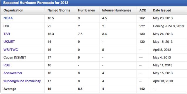
NOAA predicts active 2013 Atlantic hurricane season
In its 2013 Atlantic hurricane season outlook issued today, NOAA’s Climate Prediction Center is forecasting an active or extremely active season this year.
For the six-month hurricane season, which begins June 1, NOAA’s Atlantic Hurricane Season Outlook says there is a 70 percent likelihood of 13 to 20 named storms (winds of 39 mph or higher), of which 7 to 11 could become hurricanes (winds of 74 mph or higher), including 3 to 6 major hurricanes (Category 3, 4 or 5; winds of 111 mph or higher).
These ranges are well above the seasonal average of 12 named storms, 6 hurricanes and 3 major hurricanes.
“With the devastation of Sandy fresh in our minds, and another active season predicted, everyone at NOAA is committed to providing life-saving forecasts in the face of these storms and ensuring that Americans are prepared and ready ahead of time.” said Kathryn Sullivan, Ph.D., NOAA acting administrator. “As we saw first-hand with Sandy, it’s important to remember that tropical storm and hurricane impacts are not limited to the coastline. Strong winds, torrential rain, flooding, and tornadoes often threaten inland areas far from where the storm first makes landfall.”
Three climate factors that strongly control Atlantic hurricane activity are expected to come together to produce an active or extremely active 2013 hurricane season. These are:
A continuation of the atmospheric climate pattern, which includes a strong west African monsoon, that is responsible for the ongoing era of high activity for Atlantic hurricanes that began in 1995;
Warmer-than-average water temperatures in the tropical Atlantic Ocean and Caribbean Sea; and
El Niño is not expected to develop and suppress hurricane formation.
“This year, oceanic and atmospheric conditions in the Atlantic basin are expected to produce more and stronger hurricanes,” said Gerry Bell, Ph.D., lead seasonal hurricane forecaster with NOAA’s Climate Prediction Center. “These conditions include weaker wind shear, warmer Atlantic waters and conducive winds patterns coming from Africa."
NOAA’s seasonal hurricane outlook is not a hurricane landfall forecast; it does not predict how many storms will hit land or where a storm will strike. Forecasts for individual storms and their impacts will be provided throughout the season by NOAA’s National Hurricane Center.
New for this hurricane season are improvements to forecast models, data gathering, and the National Hurricane Center communication procedure for post-tropical cyclones. In July, NOAA plans to bring online a new supercomputer that will run an upgraded Hurricane Weather Research and Forecasting (HWRF) model that provides significantly enhanced depiction of storm structure and improved storm intensity forecast guidance.
Also this year, Doppler radar data will be transmitted in real time from NOAA’s Hurricane Hunter aircraft. This will help forecasters better analyze rapidly evolving storm conditions, and these data could further improve the HWRF model forecasts by 10 to 15 percent.
The National Weather Service has also made changes to allow for hurricane warnings to remain in effect, or to be newly issued, for storms like Sandy that have become post-tropical. This flexibility allows forecasters to provide a continuous flow of forecast and warning information for evolving or continuing threats.
“The start of hurricane season is a reminder that our families, businesses and communities need to be ready for the next big storm,” said Joe Nimmich, FEMA associate administrator for Response and Recovery. “Preparedness today can make a big difference down the line, so update your family emergency plan and make sure your emergency kit is stocked. Learn more about how you can prepare for hurricane season at www.ready.gov/hurricanes.”;
Next week, May 26 - June 1, is National Hurricane Preparedness Week. To help those living in hurricane-prone areas prepare, NOAA is offering hurricane preparedness tips, along with video and audio public service announcements in both English and Spanish, featuring NOAA hurricane experts and the FEMA administrator at www.nhc.noaa.gov/prepare/.
NOAA’s outlook for the Eastern Pacific basin is for a below-normal hurricane season and the Central Pacific basin is also expected to have a below-normal season. NOAA will issue an updated outlook for the Atlantic hurricane season in early August, just prior to the historical peak of the season.
NOAA’s mission is to understand and predict changes in the Earth's environment, from the depths of the ocean to the surface of the sun, and to conserve and manage our coastal and marine resources. Join us on Facebook, Twitter and our other social media channels.
http://www.noaanews.noaa.(...).UZ5V6zmvpBw.twitter
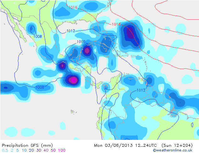
Lange termijn (begin juni) laat een systeem zien wat vanuit het Caribisch gebied de Golf van Mexico intrekt om daarna richting Florida te gaan. Vervolgens trekt deze over Florida heen, waarna de oostkust van de VS aan de beurt is.

GOES-13 is kapot 
quote:U.S. weather-watcher satellite fails just before hurricane season
CAPE CANAVERAL, Florida (Reuters) - A key satellite positioned to track severe weather in the eastern United States has failed, just as the 2013 Atlantic hurricane season is about to start.
The U.S. National Oceanic and Atmospheric Administration (NOAA) activated a spare satellite, which will provide coverage of the East Coast, while it is trying to fix the failed one, the agency said in a status report on its website on Friday.
"There is no estimate on return to operations at this time," NOAA said.
The Atlantic-Caribbean hurricane season starts on June 1 and lasts six months. NOAA expects this year's season to be "extremely active," with 13 to 20 tropical storms and seven to 11 of those strengthening into hurricanes.
The agency's three current Geostationary Operational Environmental Satellites, known as GOES, were built by Boeing and designed to last 10 years. The failed spacecraft, GOES-13, was launched in 2006.
NOAA typically operates two GOES spacecraft over the United States, overlooking the East and West coasts, plus one on-orbit spare. The satellites are outfitted with imagers to watch for clouds and developing storms, and atmospheric sounders to measure temperatures and humidity.
The first sign of trouble with GOES-13, the primary East Coast satellite, surfaced late Wednesday when it failed to relay expected images, NOAA status reports show.
GOES-13 is located over 75 degrees west longitude. Though activated, the spare remains in its storage orbit at 105 degrees west.
NOAA said it currently is not planning to drift the spare east, while efforts to troubleshoot its failed sister satellite are under way.
NOAA also has an older GOES-12 satellite, launched in 2001, parked at 60 degrees west that provides coverage of South America.
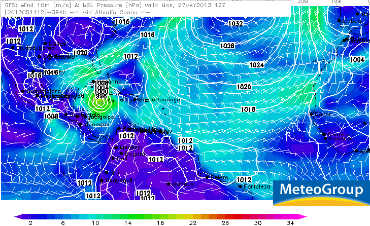
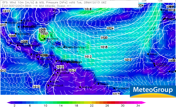
Zeer onrustig in meerdere tropische gebieden. De gevaarlijkste zitten nu bij Bangladesh en Mexico, maar ook voor de kust van Somalië is nu een invest te vinden. Ook in het caribisch gebied en de Golf van Mexico kan het over een tijdje raak zijn. GFS blijft komen met een systeem dat zich ten zuiden van Cuba ontwikkeld, waarna het de Golf induikt richting Florida.
Bangladesh
Mexico
Bangladesh
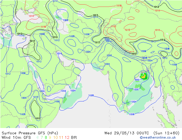
Mexico


Nu 90%quote:
[ afbeelding ]
80% voor het gebied in de Oost-Pacific, lijkt de volgende tropische storm te worden
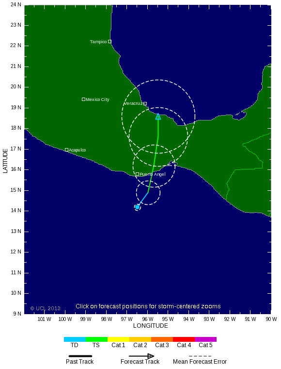


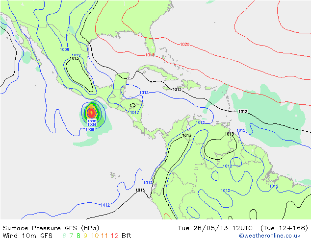
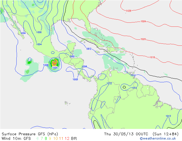
Barbara staat op het punt landfall te maken als een orkaan.
quote:Hurricane warnings are flying for the Pacific coast of Mexico, where Tropical Storm Barbara is rapidly intensifying as it makes landfall. Barbara should be ashore by 2 pm EDT (11 am PDT), and is expected to intensify to a Category 1 hurricane with 75 mph winds before landfall. Barbara formed on Tuesday night (May 28), an unusually early date for the formation of the Eastern Pacific's second storm of the year. The record earliest second storm of the year occurred just last year, on May 21 (Tropical Storm Bud.) The previous record was set in 1984, when the second named storm (Boris) formed on May 29. Reliable records of Eastern Pacific hurricanes go back to 1949. Barbara wasted no time getting organized, and is gathering strength in impressive fashion as it nears landfall in Mexico's Bay of Tehuantepec area. The storm's main threat is very heavy rains of up to a foot, which will be capable of causing dangerous flash floods and mudslides over the next 2 - 3 days. However, wind damage and the expected 3 - 5 foot storm surge are also a concern, since the area of the coast it is hitting, though not heavily populated, has very little hurricane experience. According to NOAA's Historical Hurricane Tracks website, only one Eastern Pacific hurricane has ever hit the Bay of Tehuantepec--Category 1 Hurricane Rick of 1997. Radar out of Puerto Angel, Mexico shows that Barbara has built a partial eyewall, and the storm has already spread heavy rains ashore along portions of the Mexican coast. Satellite loops show that Barbara is a relatively small storm, with a modest area of heavy thunderstorms.