WKN Weer, Klimaat en Natuurrampen
Lees alles over het onstuimige weer op onze planeet, volg orkanen en tornado's, zie hoe vulkanen uitbarsten en hoe Moeder Aarde beeft bij een aardbeving. Alles over de verwoestende kracht van onze planeet en tal van andere natuurverschijnselen.


Tyfoon voor de Indische oceaan
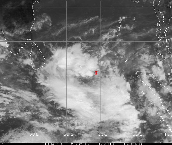
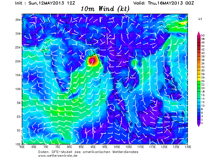
Al enkele dagen laat GFS (amerikaans weermodel) een tyfoon zien boven het water van de Indische oceaan. Het systeem ligt nu nog ten zuiden van Sri Lanka. Waarschijnlijk zal binnen een dag of 2 een tropische storm ontstaan die steeds verder in kracht zal toenemen tot een zware categorie op de schaal van Saffir en Simpson.
Het gebied waar deze tyfoon zich ontwikkeld staat bekend om het gebied waar de meeste slachtoffers zijn gevallen door tropische stormen. Het dodental loopt op tot boven de miljoen. Vooral Bangladesh is veel en hard getroffen. Veel komen ze hier niet voor, maar als ze er zijn kan dat zorgen voor dood en verderf.
Enkele bekende tyfonen van een paar jaar terug zijn b.v.: Sidr en Nargis. Nargis heeft mogelijk in 2008 voor 100.000 slachtoffers gezorgd. (De Verenigde Naties houden het voorlopig op tussen de zestigduizend en honderdduizend doden).
De meest dodelijke tyfoon ooit was Bhola in 1970. Hierbij waren ruim 500.000 doden te betreuren.
Het is afwachten, waar deze tyfoon precies heen gaat. GFS stuurt het systeem richting de kust van India en ook andere modellen laten deze richting zien. Volgens de laatste uitdraai van GFS, gaat Sri Lanka een enorme hoeveelheid neerslag krijgen met als gevolg, overstromingen en landverschuivingen.
Zie ook:
WKN / Hurricane Season 2013 #1
WKN / Cycloon Nargis eist minstens 77.000 levens in Myanmar

Al enkele dagen laat GFS (amerikaans weermodel) een tyfoon zien boven het water van de Indische oceaan. Het systeem ligt nu nog ten zuiden van Sri Lanka. Waarschijnlijk zal binnen een dag of 2 een tropische storm ontstaan die steeds verder in kracht zal toenemen tot een zware categorie op de schaal van Saffir en Simpson.
Het gebied waar deze tyfoon zich ontwikkeld staat bekend om het gebied waar de meeste slachtoffers zijn gevallen door tropische stormen. Het dodental loopt op tot boven de miljoen. Vooral Bangladesh is veel en hard getroffen. Veel komen ze hier niet voor, maar als ze er zijn kan dat zorgen voor dood en verderf.
Enkele bekende tyfonen van een paar jaar terug zijn b.v.: Sidr en Nargis. Nargis heeft mogelijk in 2008 voor 100.000 slachtoffers gezorgd. (De Verenigde Naties houden het voorlopig op tussen de zestigduizend en honderdduizend doden).
De meest dodelijke tyfoon ooit was Bhola in 1970. Hierbij waren ruim 500.000 doden te betreuren.


Het is afwachten, waar deze tyfoon precies heen gaat. GFS stuurt het systeem richting de kust van India en ook andere modellen laten deze richting zien. Volgens de laatste uitdraai van GFS, gaat Sri Lanka een enorme hoeveelheid neerslag krijgen met als gevolg, overstromingen en landverschuivingen.
Zie ook:
WKN / Hurricane Season 2013 #1
WKN / Cycloon Nargis eist minstens 77.000 levens in Myanmar

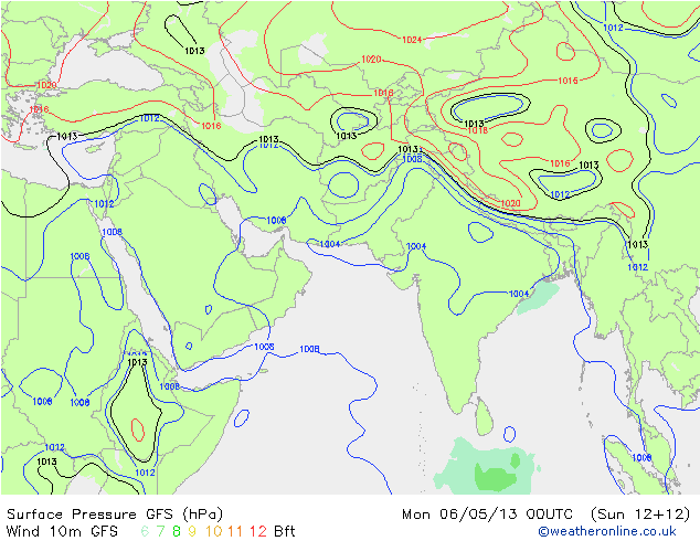

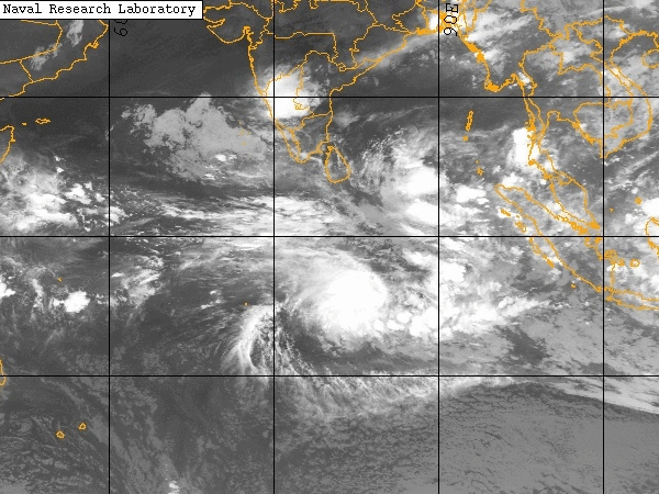
Systeem staat nog steeds in de kaarten, maar heeft moeite om zich te vormen. Kan zijn dat deze last heeft van het systeem aan de zuidkant.
GFS laat nu een minder intens complex zien, dat verder richting het oosten ontstaat en landfall maakt in de buurt van Bangladesch.
Ook CMC laat nog steeds een tropische storm zien boven de Baai van Bengalen.
GFS laat nu een minder intens complex zien, dat verder richting het oosten ontstaat en landfall maakt in de buurt van Bangladesch.
Ook CMC laat nog steeds een tropische storm zien boven de Baai van Bengalen.
Lijkt nu te gaan ontstaan. Laatste gfs uitdraai laat het systeem richting Bangladesch trekken en ook het Canadese model gaat die kant op.
Wordt een mooie tweeling straksquote:Op donderdag 9 mei 2013 11:44 schreef aloa het volgende:
Lijkt nu te gaan ontstaan. Laatste gfs uitdraai laat het systeem richting Bangladesch trekken en ook het Canadese model gaat die kant op.
[ afbeelding ]


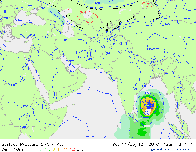
De modellen trekken nu meer naar elkaar toe en laten het systeem richting Bangladesh trekken. Vooral het Canadese model laat een behoorlijke tyfoon zien. Zeewatertemperatuur ligt boven de 30 graden, wat voor een extra boost kan zorgen.
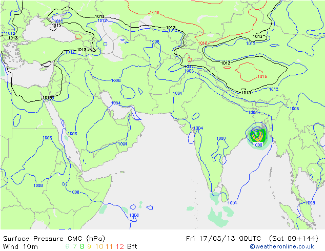
Het systeem blijft nog even boven de oceaan hangen alvorens richting land te gaan. Lijkt een catogorie 2 te worden.

100.000 katjes
Fuck the EBU!
Fuck the EBU!
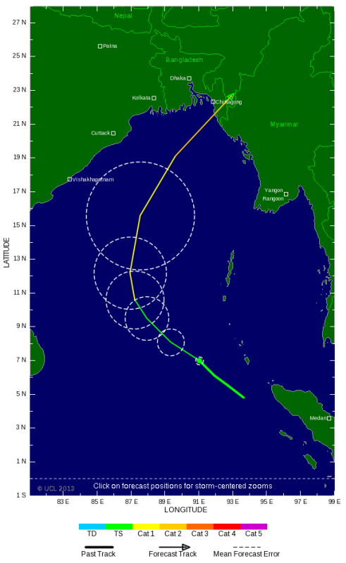
JTWC komt met een hoogste windsnelheud van 85 kts, dat is 157 km/u. Categorie 2 inderdaad.quote:Op zondag 12 mei 2013 00:09 schreef Nattekat het volgende:
Het systeem blijft nog even boven de oceaan hangen alvorens richting land te gaan. Lijkt een catogorie 2 te worden.
[ afbeelding ]
maar je weet het niet met deze systemen, kan zo maar nog extremer worden.
De piek is naar beneden bijgesteld naar 75 kts, waarmee cat. 2 niet gehaald wordt. Tevens lijkt de kans op een landfall als orkaan ook niet erg groot meer, slechts 25%.

100.000 katjes
Fuck the EBU!
Fuck the EBU!
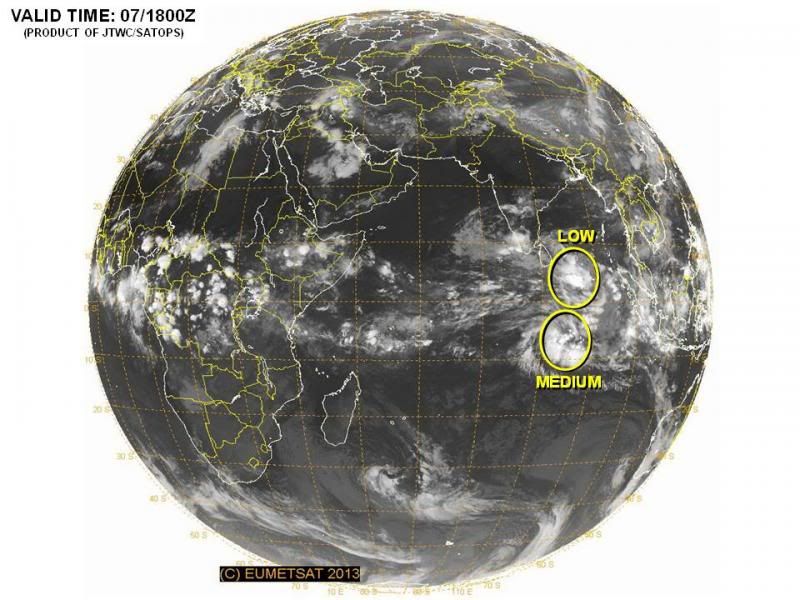
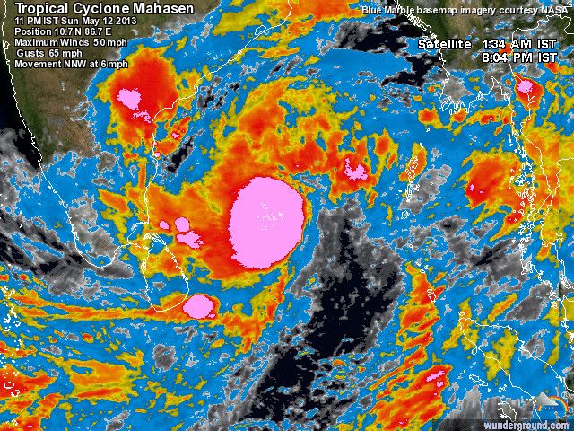
Boven India momenteel zware onweersbuien. Windveld van Mahasen is nu te vergelijken met een windkracht 9 (Beaufort).
[ Bericht 1% gewijzigd door #ANONIEM op 12-05-2013 22:21:47 ]
[ Bericht 1% gewijzigd door #ANONIEM op 12-05-2013 22:21:47 ]


quote:Bangladesh in staat van alarm
Een tropische wervelstorm bedreigt de kusten van Bangladesh en Myanmar. De autoriteiten in Bangladesh hebben wegens de cycloon in de Golf van Bengalen bijna 50.000 vrijwilligers in staat van alarm gebracht.
Bovendien werd de vissers aanbevolen niet meer uit te varen, zei de directeur van de rampenbestrijdingsdienst Abdul Wazed. Ook het leger bereidt zich op hulpverlening voor. Volgens het Indiase Cycloonwaarschuwingssysteem kan de wervelstorm Mahasen in de volgende dagen aan de grens tussen Bangladesh en Myamar de kust treffen.
In Myanmar leven in de kusstrook aan de grens met Bangladesh na de onlusten van het voorbije jaar tienduizenden mensen in hutten en tenten. Het zijn overwegend leden van de moslimminderheid Rohingya, die door boeddhistische bendes uit hun dorpen werden verdreven. De autoriteiten willen noodverblijven voor hen inrichten. Ongeveer 30 miljoen van de 153 miljoen Bengalezen leven langs de kust in Bangladesh.
Een van de zwaarste cyclonen in de regio verwoestte begin mei 2008 de Irrawaddy-delta in Myanmar. Daar kwamen minstens 138.000 mensen om het leven. De destijds regerende militaire junta liet slechts mondjesmaat internationale hulp in het land toe.
Bay of Bengal Tropical Storm Mahasen remains a dangerous threat
Posted by: Dr. Jeff Masters
It's always a nervous time when a tropical cyclone with the potential to intensify marches through the Indian Ocean's Bay of Bengal. That's because fifteen of the twenty deadliest tropical cyclones in world history have been Bay of Bengal storms that have hit Bangladesh, India, or Myanmar. The most recent of these horrifying storms was 2008's Cyclone Nargis, which killed 146,000 people in Myanmar. The Bay of Bengal's notorious history is why hurricane forecasters are watching Tropical Cyclone Mahasen a little nervously today. Even though there has been little change to the 55 mph tropical storm over the past two days, the storm remains a potential threat to undergo rapid intensification into a dangerous major hurricane. The 11 am EDT Monday advisory from the Joint Typhoon Warning Center put Mahasen's top sustained winds at 55 mph, with a motion northwest at 11 mph towards India. Satellite loops show that Mahasen has a large area of intense thunderstorms with very cold cloud tops that reach high into the atmosphere. The cloud pattern is not well-organized, with little spiral banding. This lack of organization is also apparent on radar out of Chennai. However, the cyclone has developed a respectable upper-level outflow channel to the northwest. Wind shear has decreased to a moderate 10 - 20 knots, and is continuing to decrease. Ocean waters that are an exceptionally warm 31°C (88°F), about 1°C warmer than average for this time of year. The warm ocean waters extend to great depth, and the Tropical Cyclone Heat Potential (TCHP) is over 90 J/kg/cm^2, which is favorable for rapid intensification.
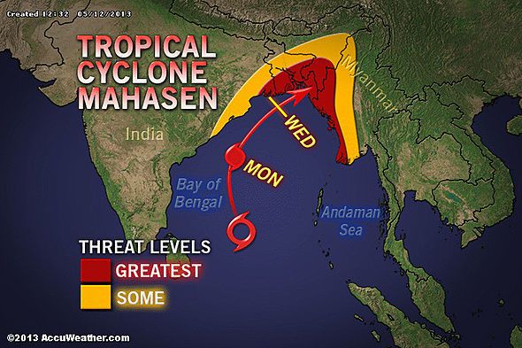
Forecast for Mahasen
The official forecast brings Mahasen to Category 1 strength before landfall occurs in Bangladesh near the Myanmar border on Thursday near 18 UTC. However, the model forecasts of Mahasen from the GFS, ECMWF, UKMET, GEM, NAVGEM, and FIM models continue to show wide disagreement on the future intensity, speed, and landfall location of the storm. It is possible that wind shear will keep the storm disorganized and below hurricane strength until landfall, as suggested by the ECMWF model. However, other model guidance, such as the 00 UTC May 13 forecast from the HWRF model, bring Mahasen to Category 2 strength by Tuesday. Mahasen is currently approaching a trough of low pressure to its northwest that is expected to recurve the storm to the northeast into Bangladesh. As the recurvature process progresses today through Tuesday, wind shear should relax to a low to moderate 5 - 15 knots, and a strong upper-level outflow channel will intensify to the storm's north, aiding intensification. There is a lot of hot, dry air to the storm's northwest over India, and if this dry air gets wrapped into Mahasen's circulation, it could put the brakes on rapid intensification, though. Considering all these factors, I give a 30% chance that Mahasen will undergo rapid intensification to a Category 3 or stronger storm by Wednesday. The storm should experience higher wind shear and less oceanic heat content in the waters beneath it in the 12 hours before landfall, which should cause some weakening. But even a weakening Category 1 storm has the potential to bring a devastating storm surge to the coast of Bangladesh, and torrential rainfall will be a major flooding threat regardless of the storm's final intensity at landfall. The 00Z May 13 run of the HWRF model predicts that the Mahasen will dump a significant area of heavy rains of 16 - 30 cm (6 - 12") over Maynmar and Bangladesh. The storm surge, high winds, and heavy rains of Mahasen are a particular concern for the thousands of Myanmar refugees living near the coast in makeshift camps, as reported by the New York Times.
JeffMasters
Posted by: Dr. Jeff Masters
It's always a nervous time when a tropical cyclone with the potential to intensify marches through the Indian Ocean's Bay of Bengal. That's because fifteen of the twenty deadliest tropical cyclones in world history have been Bay of Bengal storms that have hit Bangladesh, India, or Myanmar. The most recent of these horrifying storms was 2008's Cyclone Nargis, which killed 146,000 people in Myanmar. The Bay of Bengal's notorious history is why hurricane forecasters are watching Tropical Cyclone Mahasen a little nervously today. Even though there has been little change to the 55 mph tropical storm over the past two days, the storm remains a potential threat to undergo rapid intensification into a dangerous major hurricane. The 11 am EDT Monday advisory from the Joint Typhoon Warning Center put Mahasen's top sustained winds at 55 mph, with a motion northwest at 11 mph towards India. Satellite loops show that Mahasen has a large area of intense thunderstorms with very cold cloud tops that reach high into the atmosphere. The cloud pattern is not well-organized, with little spiral banding. This lack of organization is also apparent on radar out of Chennai. However, the cyclone has developed a respectable upper-level outflow channel to the northwest. Wind shear has decreased to a moderate 10 - 20 knots, and is continuing to decrease. Ocean waters that are an exceptionally warm 31°C (88°F), about 1°C warmer than average for this time of year. The warm ocean waters extend to great depth, and the Tropical Cyclone Heat Potential (TCHP) is over 90 J/kg/cm^2, which is favorable for rapid intensification.
Forecast for Mahasen
The official forecast brings Mahasen to Category 1 strength before landfall occurs in Bangladesh near the Myanmar border on Thursday near 18 UTC. However, the model forecasts of Mahasen from the GFS, ECMWF, UKMET, GEM, NAVGEM, and FIM models continue to show wide disagreement on the future intensity, speed, and landfall location of the storm. It is possible that wind shear will keep the storm disorganized and below hurricane strength until landfall, as suggested by the ECMWF model. However, other model guidance, such as the 00 UTC May 13 forecast from the HWRF model, bring Mahasen to Category 2 strength by Tuesday. Mahasen is currently approaching a trough of low pressure to its northwest that is expected to recurve the storm to the northeast into Bangladesh. As the recurvature process progresses today through Tuesday, wind shear should relax to a low to moderate 5 - 15 knots, and a strong upper-level outflow channel will intensify to the storm's north, aiding intensification. There is a lot of hot, dry air to the storm's northwest over India, and if this dry air gets wrapped into Mahasen's circulation, it could put the brakes on rapid intensification, though. Considering all these factors, I give a 30% chance that Mahasen will undergo rapid intensification to a Category 3 or stronger storm by Wednesday. The storm should experience higher wind shear and less oceanic heat content in the waters beneath it in the 12 hours before landfall, which should cause some weakening. But even a weakening Category 1 storm has the potential to bring a devastating storm surge to the coast of Bangladesh, and torrential rainfall will be a major flooding threat regardless of the storm's final intensity at landfall. The 00Z May 13 run of the HWRF model predicts that the Mahasen will dump a significant area of heavy rains of 16 - 30 cm (6 - 12") over Maynmar and Bangladesh. The storm surge, high winds, and heavy rains of Mahasen are a particular concern for the thousands of Myanmar refugees living near the coast in makeshift camps, as reported by the New York Times.
JeffMasters
Boot met vluchtelingen kapseist voor kust Myanmar
Een boot met honderd Rohingya moslims is gekapseisd voor de westkust van Myanmar. Ze waren op de vlucht voor de cycloon Mahasen, die de laag gelegen regio’s van het Rakhinegebied bedreigt.
De tropische storm bedreigt de delen van Myanmar waar zo’n 140.000 vluchtelingen voor etnisch en religieus geweld in kampen verblijven. De Verenigde Naties waarschuwden vorige week al dat een humanitaire catastrofe dreigt als de vluchtelingen niet snel geëvacueerd zouden worden.
AP
Tijdens die massa-evacuatie botste één boot met minstens honderd vluchtelingen maandagnacht op rotsen, iets voor de kust van de stad Pauktaw. Zeker vijftig mensen zouden verdronken zijn. Anderen zijn nog vermist.
De boot maakte deel uit van een vloot van zes schepen die uit de stad waren vertrokken en vluchtelingen naar een ander kamp zouden evacueren.
Religieuze strijd
Volgens de Verenigde Naties dreigen in de regio 69.000 mensen, van wie de meeste Rohingya moslims, schade te lijden tijdens het regenseizoen, dat deze maand van start gaat en duurt tot september.
In de staat Rakhine heersen etnische spanningen tussen de autochtone Rakhine-boeddhisten en de islamitische Rohingya-minderheid. Vooral die laatste groep moet het erg ontgelden, met meer dan 100.000 vluchtelingen en honderden doden tot gevolg.
bron
|
|