WKN Weer, Klimaat en Natuurrampen
Lees alles over het onstuimige weer op onze planeet, volg orkanen en tornado's, zie hoe vulkanen uitbarsten en hoe Moeder Aarde beeft bij een aardbeving. Alles over de verwoestende kracht van onze planeet en tal van andere natuurverschijnselen.


El Golfo, El Hierro, De plek waar de meeste aardbevingen zijn geregistreerd
quote:Recordaantal aardbevingen op Canarisch eiland
Nog nooit eerder werden er zoveel aardbevingen achter elkaar geregistreerd op het kleine vulkanische eilandje El Hierro, het kleinste van de Canarische Eilanden. De reeks van maar liefst 720 bevinkjes heeft de overheid van deze eilandengroep voor de kust van West Afrika ertoe doen besluiten om voor het eerst in de geschiedenis een vergadering bijeen te roepen van het Stuurcomité van Vulkanische Monitoring. Dit comité werd opgericht om specifieke plannen te realiseren, die de burgerbevolking dienen te beschermen en noodplannen voor vulkanische risico’s moeten ontwikkelen. Inmiddels wordt gesproken over een ‘significante dreiging van seismische activiteit’.
Het Nationaal Geografisch Instituut (IGN) en het Volcanologische Instituut van de Canarische eilanden blijft nauwlettend de aardbevingen in de gaten houden, waarvan de kracht van de bevingen (elke dag!) ligt tussen de 1 en 3 op de Richterschaal. De meerderheid van de bevingen vindt plaats tussen 5 en 15 km diepte.
Volgens de autoriteiten betekent deze seismische activiteit nog niet direct dat een grotere, significante aardbeving zal plaatsvinden. Het merendeel van de bevingen die zijn geregistreerd, vonden plaats in het Noord Westen van het 280 vierkante kilometer kleine eilandje, bij het plaatsje El Golfo (zie foto hieronder). Een aardbeving op deze plaats zorgde er zo’n 50.000 jaar geleden voor, dat er een enorme landverschuiving plaatsvond, waarbij de helft van de vulkaan in zee gleed. Hierdoor ontstond een ca. 100 meter hoge tsunami die naar de overzijde van de Atlantische oceaan zou zijn gegleden. Schuin tegenover dit eilandje, in het verlengde van de resterende halve kratermond, ligt het Noord Amerikaanse continent..
quote:El Hierro Earthquake Swarm Enters Third Week
The intensity of earthquakes recorded on the smallest of the Canary Islands, El Hierro, has increased slightly during the last 24 hours. However, the total number of earthquakes recorded daily has lessened since the earthquake swarm initially began on 17 July.
The total number of tremors recorded during the past two weeks has now exceeded 1,050, according to the Instituto Geografico Nacional (IGN).
The majority of the earth tremors ranged between 1-2 magnitude, but during the past 24 hours there have been least five tremors measuring in excess of 2.0 magnitude on the Richter Scale. A 2.4 magnitude earthquake was recorded at 4:56 p.m. local time on Sunday (31 July 2011).
Approximately 50 earth tremors were recorded on Sunday, according to local earthquake monitoring agency Actualidad Volcánica de Canarias (AVCAN). The number is slightly down on the number of tremors recorded on Saturday and significantly less than the 195 earthquakes recorded on 22 July.
(enkele video's zijn in de OP van het vorige topic te vinden)quote:The vast majority of the tremors have been recorded in the northwest of the 278.5-square-kilometre island at El Golfo, the location of a massive landslide that created a 100-metre high tsunami almost 50,000 years ago.
The earthquake swarm, prompted the Canary Islands Government to convene the first ever meeting on 22 July of the Steering Committee and Volcanic Monitoring, reflected in the Specific Plan Protection Civil and Emergency for Volcanic Risk, given what it described “the significant increase in seismic activity”. The Committee met again on Friday 29 July to discuss the low magnitude seismic activity. It reported that it had stepped up its seismic monitoring operations to identify the source of the earthquakes.
Following an evaluation of seismic and volcanological information gathered by the IGN and volcanological Institute of the Canary Islands, the Committee agreed to activate “monitoring and surveillance mechanisms necessary to coordinate the actions of civilian self-protection and information to people listed in the Plan” (translated from Spanish press release). It remains unclear, however, if the unprecedented seismic activitiy on El Hierro is a precursor to a possible future increase in earthquake or volcanic activity.
Earthquake swarms are events where a local area experiences sequences of many earthquakes striking in a relatively short period of time. The length of time used to define the swarm itself varies, but the United States Geological Survey (USGS) points out that an event may last for days, weeks, or months.
El Hierro’s Volcanic/Seismic Past
El Hierro is situated in the most southwestern extreme of the Canaries. The island was formed after three successive eruptions, and consequent accumulations, the island emerged from the ocean as an imposing triangular pyramid crowned by a volcano more than 2,000 metres high.
The volcanic activity, principally at the convergence of the three ridges, resulted in the continual expansion of the island. A mere 50,000 years ago, as a result of seismic tremors which produced massive landslides, a giant piece of the island cracked off, crashed down into the ocean and scattered along the seabed. This landslide of more than 300km3 gave rise to the impressive amphitheatre of the El Golfo valley and at the same time caused a tsunami that most likely rose over 100 metres high and probably reached as far as the American coast.
Status Vandaag de dag:
17-09-2012
Sinds de uitbarsting in de zee ten zuiden van het eiland (bij La Restinga) is gestopt is het langere tijd redelijk rustig geweest. "Rustig" betekent in dit geval een paar zwakke bevingen per dag - of een tijdje zelfs bijna geen bevingen - tot het afgelopen weekend.
In de afgelopen paar weken was te merken dat er een verhoogde activiteit werd waargenomen. Een redelijk aantal bevingen, zwakke en iets minder zwakke. En dan hebben we het over bevingen die door IGN (spaans geologisch instituut) vaak niet werden weer gegeven (onder de 1,5). De bevingen die wel werden weergegeven waren dan zelden boven de 2,5 (nauwelijks waarneembaar voor de bevolking).
Begin Juni was er in eens weer een verhoogde activiteit. Bevingen die weer goed boven de 1,5 uit kwamen. Halverwege de maand werd in eens duidelijk dat het eiland "vervormde" en dat het snel ging. De grafiekjes lieten zien dat het eiland sterk omhoog getild werd (een paar CM).

De rust kwam weer een beetje terug. En afgelopen vrijdag was het in eens weer helemaal raak.
Er was op de grafieken vrijwel geen moment meer rustig en het eiland is sinds dien sterker aan het stijgen gegaan. Sinds het begin van de activiteit in juli 2011 is het eiland inmiddels 15 CM omhoog gekomen. Het afgelopen weekend met een spurt.

Waar bij de vorige groeispurt de groei best heen en weer ging is het nu zo goed als alleen maar omhoog. (hoewel het misschien nog te vroeg is om dat te roepen)
Inmiddel zijn de bevingen wel afgezwakt, maar nog wel aanwezig.
Links
Live webcams op het eiland El Hierro
Zelfde webcams via andere link
Actuele seismische activiteit
AVCan - vulcanologiesch instituut Canarische eilanden
Spaans geografisch instituut
INVOLCAN Facebook pagina
AVCAN facebook pagina
Canariesnews
Tumbit
en op twitter kun je zoeken op #hierro, #elhierro of #viveelhierro
@noticiacanaria Wel veel ander nieuws
@canariesnews
@eruptionsblog
@teideano 1 van de onderzoekers op El Hierro
Gerelateerde topics
[Vulkanen] The ring of fire #6: Waar diverse vulkanen puffen
Aardbevingen #13
Mega tsunami door in zee vallen van eiland La Palma?
[ Bericht 19% gewijzigd door bwt op 17-09-2012 21:31:52 ]
<a href="http://goo.gl/q8fhTe" target="_blank">FAQ?</a>
<a href="http://goo.gl/gYvZFq" target="_blank">Geel is een zonnige en vrolijke kleur, als hij tenminste enigszins warm is gekleurd en wat naar het oranje neigt</a>
<a href="http://goo.gl/gYvZFq" target="_blank">Geel is een zonnige en vrolijke kleur, als hij tenminste enigszins warm is gekleurd en wat naar het oranje neigt</a>

Spannend, zijn er doden, is CNN al ter plaatse? 
De oude oude layout was veel beter!!
vosss is de naam,
vosss is de naam,
Ik zal vanavond enige updates in de OP gooien (of in deze post)
Sorry VOSSSSS, het rommelt momenteel alleen, meer niet.
De drukte van het afgelopen weekend:
En vandaag:
[ Bericht 35% gewijzigd door bwt op 17-09-2012 21:37:37 ]
Sorry VOSSSSS, het rommelt momenteel alleen, meer niet.
De drukte van het afgelopen weekend:


En vandaag:

quote:Op maandag 17 september 2012 13:16 schreef bwt het volgende:
twitter:teideano twitterde op maandag 17-09-2012 om 12:04:41 #volcano New GPS data from El Hierro. Inflation continues with a high rate. 2.81 cm up in PINA in just 3 days... http://t.co/d67M7KpP reageer retweet


quote:twitter:teideano twitterde op maandag 17-09-2012 om 13:27:20 #volcano New GPS data from El Hierro. Inflation continues with a high rate. 3.13 cm up in REST in just 3 days... http://t.co/Vu7CeU4H reageer retweet

quote:twitter:teideano twitterde op maandag 17-09-2012 om 13:45:31 #photography Anciente lava flow at El Hierro, Canary Islands, actually suffering a big seismic swarm #volcano http://t.co/XKL1xSte reageer retweet

[ Bericht 35% gewijzigd door bwt op 17-09-2012 21:37:37 ]
<a href="http://goo.gl/q8fhTe" target="_blank">FAQ?</a>
<a href="http://goo.gl/gYvZFq" target="_blank">Geel is een zonnige en vrolijke kleur, als hij tenminste enigszins warm is gekleurd en wat naar het oranje neigt</a>
<a href="http://goo.gl/gYvZFq" target="_blank">Geel is een zonnige en vrolijke kleur, als hij tenminste enigszins warm is gekleurd en wat naar het oranje neigt</a>
terugvindquakeswarm
Inorbit: zeg dat dan typluie triangeljosti
Beauregard: Een beetje FOK!ker laat het brood door z'n moeder smeren.
Ecosia
ek's 'n flash drive, jy's 'n floppy
Beauregard: Een beetje FOK!ker laat het brood door z'n moeder smeren.
Ecosia
ek's 'n flash drive, jy's 'n floppy

<a href="http://goo.gl/q8fhTe" target="_blank">FAQ?</a>
<a href="http://goo.gl/gYvZFq" target="_blank">Geel is een zonnige en vrolijke kleur, als hij tenminste enigszins warm is gekleurd en wat naar het oranje neigt</a>
<a href="http://goo.gl/gYvZFq" target="_blank">Geel is een zonnige en vrolijke kleur, als hij tenminste enigszins warm is gekleurd en wat naar het oranje neigt</a>
Alert level is nog altijd "groen" / veiligquote:Update 17/09 – 15:36 UTC
- Is the crust starting to show cracks ? Why are we writing this ? If IGN data are correct, we have noticed a number of shallower earthquakes the last couple of hours. Nothing to be scared off, but this is definitely a change in patterns versus earlier today and the 2 preceding days. From 12:27 until 14:39 (less than 3 hours) we have noticed 6 under 20 km earthquakes on a total of 17.
The shallowest being a 13 km, but also a 15 km and a couple of 18 km. Is the magma the cause ? IGN would probably know it but mostly keeps his information for international science conferences a couple of months later!
The shallowest one was recorded below the Sabinosa area, the area where the other 10 km were recorded last week.
- 71 earthquakes so far
Update 17/09 – 17:05 UTC
- 84 earthquakes until 16:11 UTC
- Another 2 shallow quakes at 10 and 11 km , both in the El Golfo, Sabinosa area. The phenomena described in the last update is being confirmed with these quakes. The Sabinosa – El Golfo area has become active again. We are however unsure whether IGN has deliberately omitted the quakes in this area when the strong swarm started. If this was not the case (what we should find very normal) then we can speak of a changing pattern. The following hours will give a better idea of the situation
Update 17/09 – 20:01 UTC
- 95 earthquakes, all the recent ones at 20 km or deeper
<a href="http://goo.gl/q8fhTe" target="_blank">FAQ?</a>
<a href="http://goo.gl/gYvZFq" target="_blank">Geel is een zonnige en vrolijke kleur, als hij tenminste enigszins warm is gekleurd en wat naar het oranje neigt</a>
<a href="http://goo.gl/gYvZFq" target="_blank">Geel is een zonnige en vrolijke kleur, als hij tenminste enigszins warm is gekleurd en wat naar het oranje neigt</a>

Each red dot represents an earthquake registered at El Hierro in the Canary Islands from September 13-16, 2012. Most are at depths of 18-22 km below the surface of the island.
quote:A quick weekend note about a volcano we haven’t heard from for much of 2012: El Hierro. Seismicity under El Hierro have increased since September 13 after months to very low activity and since Friday, over 300 earthquakes have occurred. These earthquakes are mostly deep (18-22 km) and under the central part of the island (see above), and have now reached over 115 earthquakes in the past 24 hours. This sharp increase at depth might suggest a new body of magma is intruding underneath the island. Combine that with the observation of deformation of the land surface at El Hierro, and you can be fairly confidence that new material is entering. However, as with any observations such as these at an active volcano, the big question is whether this will lead to an eruption and that is very unclear. Intrusion without eruption happen frequently at volcano, so we may only be seeing the normal activity at a hotspot volcano like El Hierro. Only if the seismicity continues and become more shallow, the deformation increases and the release of volcanic gases such as carbon dioxide or sulfur dioxide increase can we begin to wonder if another eruption at El Hierro is in the works.
IGN is monitoring the situation at El Hierro, but not decision has been made to increase the alert status at the island volcano (which currently sits at Semaforo Verde, the lowest alert).

rood - afgelopen 3 dagen
blauw - 2-4 dagen
lichtblauw vanaf 24-6
<a href="http://goo.gl/q8fhTe" target="_blank">FAQ?</a>
<a href="http://goo.gl/gYvZFq" target="_blank">Geel is een zonnige en vrolijke kleur, als hij tenminste enigszins warm is gekleurd en wat naar het oranje neigt</a>
<a href="http://goo.gl/gYvZFq" target="_blank">Geel is een zonnige en vrolijke kleur, als hij tenminste enigszins warm is gekleurd en wat naar het oranje neigt</a>
Niet op La Palma?
Er is lange tijd een hype geweest dat wanneer die vulkaan zou uitbarsten, het een mega-tsunami zou kunnen veroorzaken die de complete oostkust van de verenigde staten zou bedreigen.
Er is lange tijd een hype geweest dat wanneer die vulkaan zou uitbarsten, het een mega-tsunami zou kunnen veroorzaken die de complete oostkust van de verenigde staten zou bedreigen.
Ja die hype wordt elk topic wel ff genoemd...quote:
Niet op La Palma?
Er is lange tijd een hype geweest dat wanneer die vulkaan zou uitbarsten, het een mega-tsunami zou kunnen veroorzaken die de complete oostkust van de verenigde staten zou bedreigen.
en er was ook een topic over
Mega tsunami door in zee vallen van eiland La Palma?

quote:Update 18/09 – 11:37 UTC
Flat lines again in El Hierro – The swarm has suddenly stopped which means that we are still at 10 earthquakes since midnight
- nobody will be able to predict what will happen now. The swarm started after increasing weak seismicity in the El Golfo area . The graph still shows some micro-seismicity, but this sudden halt comes also as a surprise to us.
Update 18/09 – 08:01 UTC
- Only 10 earthquakes so far today. The swarm was very short-lived this time.
- Only the last one at 06:03 was shallower than the rest (11 km) – epicenter near Sabinosa
- Except for the 11 km earthquakes all other epicenters are located in the old crater area (like the images below)
- It is clear that there are 2 magma feeders at work , a weak one below the El Golfo – Sabinosa area and a main feeder who originates below the island and is searching for an exit. During the first eruption it succeeded in finding a system to reach the Las Calmas sea. During the second swarm, the western part of the island showed to be too strong to overcome. The current third swarm does not succeed to get to upper layers (very fortunate for the population on the island, and is subsiding already now
- Deformations
Restinga : slight uplift of approx. 0.5 cm
Pinar and Frontera : slight uplift and pressure to the North (both a couple of mm)
Deformations are confirming the earthquake trend, less inflation today than yesterday
<a href="http://goo.gl/q8fhTe" target="_blank">FAQ?</a>
<a href="http://goo.gl/gYvZFq" target="_blank">Geel is een zonnige en vrolijke kleur, als hij tenminste enigszins warm is gekleurd en wat naar het oranje neigt</a>
<a href="http://goo.gl/gYvZFq" target="_blank">Geel is een zonnige en vrolijke kleur, als hij tenminste enigszins warm is gekleurd en wat naar het oranje neigt</a>
Whut? zijn er veel topic's over vulkanen dan?quote:
[..]
Ja die hype wordt elk topic wel ff genoemd...
en er was ook een topic over
Mega tsunami door in zee vallen van eiland La Palma?
Nooit geweten dat dat zo'n hot issue is.
twitter:teideano twitterde op woensdag 19-09-2012 om 10:46:25 #volcano More GPS data. REST station inflating at quick pace. 4,81 cm in 6 days. #earthqueake number up to 16185... http://t.co/bAmtkNIa reageer retweet

<a href="http://goo.gl/q8fhTe" target="_blank">FAQ?</a>
<a href="http://goo.gl/gYvZFq" target="_blank">Geel is een zonnige en vrolijke kleur, als hij tenminste enigszins warm is gekleurd en wat naar het oranje neigt</a>
<a href="http://goo.gl/gYvZFq" target="_blank">Geel is een zonnige en vrolijke kleur, als hij tenminste enigszins warm is gekleurd en wat naar het oranje neigt</a>
Zeker..... er is een centrale reeks over vulkanenquote:
[..]
Whut? zijn er veel topic's over vulkanen dan?
Nooit geweten dat dat zo'n hot issue is.
[Vulkanen] The ring of fire #6: Waar diverse vulkanen puffen
en een greep uit vulkaantopics van de laatste weken...
Seismische onrust rondom Santorini Griekenland
Volcán de Fuego barst uit in Guatemala
Vulkaanuitbarsting bij Canarische Eilanden #5
Vulkanen IJsland #18: Verhoogde activiteit
Meerdere Indonesische vulkanen raken op stoom
De jacuzzi kan straks weer aanquote:[ afbeelding ]twitter:teideano twitterde op woensdag 19-09-2012 om 10:46:25 #volcano More GPS data. REST station inflating at quick pace. 4,81 cm in 6 days. #earthqueake number up to 16185... http://t.co/bAmtkNIa reageer retweet
quote:2012-09-19 13:22
- Apparently nothing is happening at El Hierro (at least no more earthquakes)
- seismicity is back to pre-swarm values
2012-09-19 10:16
- 23 earthquakes in total yesterday, the last one being a M1.7 at 14 km
- 7 earthquakes so far this morning, 2 at a depth of 10 km (El Golfo and Las Calmas), the rest at approx. 20 km deep in the old crater area and El Pinar area
- GPS deformations :
Frontera : a few mm further inflated, a couple of mm to the North-East
Pinar : stabilised in horizontal and vertical axis (normal as with the decrease in number and strength of the earthquakes, the pressure below the center of the island has strongly subsided)
Restinga : comes as a surprise – Restinga is pushed a few mm to the east and has a further strong inflation of nearly 1.5 cm Ultra Rapid preliminary results)
<a href="http://goo.gl/q8fhTe" target="_blank">FAQ?</a>
<a href="http://goo.gl/gYvZFq" target="_blank">Geel is een zonnige en vrolijke kleur, als hij tenminste enigszins warm is gekleurd en wat naar het oranje neigt</a>
<a href="http://goo.gl/gYvZFq" target="_blank">Geel is een zonnige en vrolijke kleur, als hij tenminste enigszins warm is gekleurd en wat naar het oranje neigt</a>
Het blijft rustig verder
<a href="http://goo.gl/q8fhTe" target="_blank">FAQ?</a>
<a href="http://goo.gl/gYvZFq" target="_blank">Geel is een zonnige en vrolijke kleur, als hij tenminste enigszins warm is gekleurd en wat naar het oranje neigt</a>
<a href="http://goo.gl/gYvZFq" target="_blank">Geel is een zonnige en vrolijke kleur, als hij tenminste enigszins warm is gekleurd en wat naar het oranje neigt</a>

Dit is de 7.3 van colombia.
Heeft er 11 minuten over gedaan om van colombia naar de canarische eilanden te komen.
<a href="http://goo.gl/q8fhTe" target="_blank">FAQ?</a>
<a href="http://goo.gl/gYvZFq" target="_blank">Geel is een zonnige en vrolijke kleur, als hij tenminste enigszins warm is gekleurd en wat naar het oranje neigt</a>
<a href="http://goo.gl/gYvZFq" target="_blank">Geel is een zonnige en vrolijke kleur, als hij tenminste enigszins warm is gekleurd en wat naar het oranje neigt</a>
das rap!quote:
[ afbeelding ]
Dit is de 7.3 van colombia.
Heeft er 11 minuten over gedaan om van colombia naar de canarische eilanden te komen.
Inorbit: zeg dat dan typluie triangeljosti
Beauregard: Een beetje FOK!ker laat het brood door z'n moeder smeren.
Ecosia
ek's 'n flash drive, jy's 'n floppy
Beauregard: Een beetje FOK!ker laat het brood door z'n moeder smeren.
Ecosia
ek's 'n flash drive, jy's 'n floppy

ging t reizen maar zo snel 
ff retourtje lanzarote
ff retourtje lanzarote
| Wordfeud: marcel-o |plug.dj/uptempo |<-- draai zelf je platen
Hmmm, Past niet bij el hierro maar gaat om actie bij de buurman - La Palma
twitter:teideano twitterde op vrijdag 05-10-2012 om 13:34:05 @eruptionsblog @rschott @jonfr500 LP´s at La Palma? mmmmm...will upload spectra in a second... http://t.co/j9ZpZiSH reageer retweet
 @eruptionsblog @
twitter:teideano twitterde op vrijdag 05-10-2012 om 13:34:48 @eruptionsblog @rschott @jonfr500 so my firends...what do you think ´bout that? http://t.co/WQvtilUe reageer retweet
<a href="http://goo.gl/q8fhTe" target="_blank">FAQ?</a>
<a href="http://goo.gl/gYvZFq" target="_blank">Geel is een zonnige en vrolijke kleur, als hij tenminste enigszins warm is gekleurd en wat naar het oranje neigt</a>
<a href="http://goo.gl/gYvZFq" target="_blank">Geel is een zonnige en vrolijke kleur, als hij tenminste enigszins warm is gekleurd en wat naar het oranje neigt</a>
Oh noes! Dan raakt gelijk heel de wereld in paniekquote:
Hmmm, Past niet bij el hierro maar gaat om actie bij de buurman - La Palmatwitter:teideano twitterde op vrijdag 05-10-2012 om 13:34:05 @eruptionsblog @rschott @jonfr500 LP´s at La Palma? mmmmm...will upload spectra in a second... http://t.co/j9ZpZiSH reageer retweettwitter:teideano twitterde op vrijdag 05-10-2012 om 13:34:48 @eruptionsblog @rschott @jonfr500 so my firends...what do you think ´bout that? http://t.co/WQvtilUe reageer retweet
quote:2012-11-23 15:24 UTC
- We continue following eventual events on the island, but the last couple of weeks all activity calmed down. The last 5 days, we only could find 2 volcanic earthquakes below the island
Lijkt er op dat de activiteit nu echt wel voorblij is.quote:2012-11-26 17:56 UTC
- NO activity whatsoever since the last 2 days - this update especially for Suzanne who thinks that we are not following up El Hierro anymore )
Mocht er tocht iets gebeuren dan lees je het hier waarschijnlijk als eerste.....
<a href="http://goo.gl/q8fhTe" target="_blank">FAQ?</a>
<a href="http://goo.gl/gYvZFq" target="_blank">Geel is een zonnige en vrolijke kleur, als hij tenminste enigszins warm is gekleurd en wat naar het oranje neigt</a>
<a href="http://goo.gl/gYvZFq" target="_blank">Geel is een zonnige en vrolijke kleur, als hij tenminste enigszins warm is gekleurd en wat naar het oranje neigt</a>

Je maakt wel mensen blij met een dode mus 
En dat 'als eerste' neem ik ook maar met een korreltje zout. Laatste update van de 26e, dat is alweer meer dan een halve week geleden

Maar alle complimenten voor je inzet
En dat 'als eerste' neem ik ook maar met een korreltje zout. Laatste update van de 26e, dat is alweer meer dan een halve week geleden
Maar alle complimenten voor je inzet
Als het niet met een hamer te repareren is, is het een elektrisch probleem.
Ik blijf het in de gaten houden inderdaad.
Daarom meld ik zo af en toe wat incidentele gevallen.
Zoals een 2.9 beving van vanmorgen
1176959 02/12/2012 05:17:37 27.6701 -18.1441 19 2.9 4 W EL PINAR.IHI
En dan noem ik het hele rijtje maar gelijk van de afgelopen tijd:
1176829 30/11/2012 14:58:43 27.7312 -18.1721 20 2.5 mbLg W FRONTERA.IHI [+]
1176709 29/11/2012 22:23:15 27.7646 -18.0878 9 2.2 mbLg W FRONTERA.IHI [+]
1176515 28/11/2012 09:00:54 27.6841 -18.0419 22 I-II 2.2 mbLg SW EL PINAR.IHI [+]
1176142 24/11/2012 17:52:33 27.7467 -18.2608 28 2.1 mbLg W FRONTERA.IHI [+]
1176102 24/11/2012 03:24:09 27.7007 -18.0734 18 1.8 mbLg W EL PINAR.IHI [+]
1176101 24/11/2012 03:18:37 27.6922 -18.1170 21 2.7 mbLg SW FRONTERA.IHI [+]
Dit betekent dat er eigenlijk niet al te veel gebeurd.
Daarom meld ik zo af en toe wat incidentele gevallen.
Zoals een 2.9 beving van vanmorgen

1176959 02/12/2012 05:17:37 27.6701 -18.1441 19 2.9 4 W EL PINAR.IHI

En dan noem ik het hele rijtje maar gelijk van de afgelopen tijd:
1176829 30/11/2012 14:58:43 27.7312 -18.1721 20 2.5 mbLg W FRONTERA.IHI [+]
1176709 29/11/2012 22:23:15 27.7646 -18.0878 9 2.2 mbLg W FRONTERA.IHI [+]
1176515 28/11/2012 09:00:54 27.6841 -18.0419 22 I-II 2.2 mbLg SW EL PINAR.IHI [+]
1176142 24/11/2012 17:52:33 27.7467 -18.2608 28 2.1 mbLg W FRONTERA.IHI [+]
1176102 24/11/2012 03:24:09 27.7007 -18.0734 18 1.8 mbLg W EL PINAR.IHI [+]
1176101 24/11/2012 03:18:37 27.6922 -18.1170 21 2.7 mbLg SW FRONTERA.IHI [+]

Dit betekent dat er eigenlijk niet al te veel gebeurd.
<a href="http://goo.gl/q8fhTe" target="_blank">FAQ?</a>
<a href="http://goo.gl/gYvZFq" target="_blank">Geel is een zonnige en vrolijke kleur, als hij tenminste enigszins warm is gekleurd en wat naar het oranje neigt</a>
<a href="http://goo.gl/gYvZFq" target="_blank">Geel is een zonnige en vrolijke kleur, als hij tenminste enigszins warm is gekleurd en wat naar het oranje neigt</a>
quote:2012-12-10 23:58 UTC
- Rather lot of activity today (thank you ER reader Gos for informing us). In only 35 minutes various vcery weak volcanic earthquakes below the center of the island gradually shifting to the south. Depths like the latest swarm. The next 48 hours will indicate whether this was a unique event or wether a new episode will start.

Ik gok dat alles gewoon tot rust aan het komen is.
<a href="http://goo.gl/q8fhTe" target="_blank">FAQ?</a>
<a href="http://goo.gl/gYvZFq" target="_blank">Geel is een zonnige en vrolijke kleur, als hij tenminste enigszins warm is gekleurd en wat naar het oranje neigt</a>
<a href="http://goo.gl/gYvZFq" target="_blank">Geel is een zonnige en vrolijke kleur, als hij tenminste enigszins warm is gekleurd en wat naar het oranje neigt</a>
quote:2012-12-15 22:02 UTC
- It is getting more and more interesting again (Thanks Goz for pushing us). One of the strongest earthquakes occurred on Thursday, a M2.6 which was felt by the islanders. This stronger earthquake indicated still the strength at the +20 km layer. The other earthquakes are occurring in the shallower 10 km depth zone, but these are weak to very weak. What happened the last couple of days has almost the same patters than during the last serious swarm episode (2 layers – the strongest ones at +20, the weaker ones at the 10 km level)

Ja. of misschien gaat het toch weer door. Het begint wel weer lekker te rommelen daar onder.
Maar dat zullen we moeten afwachten.

De eerste beving voor vandaag staat er al weer op.
Die dikke lijnen zou door het weer kunnen komen. is eerder ook al eens geweest.
Het plaatje laat meer wind zien dan tremmors
Anyway - een paar KM verder naar boven - 40 KM buiten de kust van tenerife is een beving geweest.
1179598 17/12/2012 10:08:22 28.8410 -15.5641 46 4.7 3 ATLÁNTICO-CANARIAS
[ Bericht 20% gewijzigd door bwt op 18-12-2012 20:35:55 ]

Het plaatje laat meer wind zien dan tremmors
Anyway - een paar KM verder naar boven - 40 KM buiten de kust van tenerife is een beving geweest.
1179598 17/12/2012 10:08:22 28.8410 -15.5641 46 4.7 3 ATLÁNTICO-CANARIAS

[ Bericht 20% gewijzigd door bwt op 18-12-2012 20:35:55 ]
<a href="http://goo.gl/q8fhTe" target="_blank">FAQ?</a>
<a href="http://goo.gl/gYvZFq" target="_blank">Geel is een zonnige en vrolijke kleur, als hij tenminste enigszins warm is gekleurd en wat naar het oranje neigt</a>
<a href="http://goo.gl/gYvZFq" target="_blank">Geel is een zonnige en vrolijke kleur, als hij tenminste enigszins warm is gekleurd en wat naar het oranje neigt</a>
En ook El Hierro geeft de beste wensen voor het nieuwe jaar......
Veel wind en weers invloeden zitten er doorheen.
De laatste 2 dagen
De afgelopen half jaar
[ Bericht 1% gewijzigd door bwt op 01-01-2013 13:33:43 ]
twitter:pabloj_gonzalez twitterde op dinsdag 01-01-2013 om 03:17:18 2012 says goodbye with a small swarm of volcano-tectonic earthquakes at N-NW coast of El Hierro Island http://t.co/iUuMtSJ7 reageer retweet
 2012 says goodbye with a small swarm of volcano-tectonic earthquakes at N-NW coast of El Hierro Island
 Op de grafieken is het niet heel goed te zien - maar ze zijn er wel.quote:IGN seismic data
1183877 01/01/2013 07:05:57 27.8127 -18.0045 17 2.3 mbLg N FRONTERA.IHI [+]
1183875 01/01/2013 06:21:35 27.8081 -17.9918 17 2.2 mbLg N FRONTERA.IHI [+]
1183873 01/01/2013 06:06:12 27.8178 -18.0247 18 1.8 mbLg NW FRONTERA.IHI [+]
1183849 01/01/2013 05:54:26 27.7623 -18.0231 18 1.7 mbLg W FRONTERA.IHI [+]
1183847 01/01/2013 05:46:06 27.8013 -18.0238 17 1.8 mbLg NW FRONTERA.IHI [+]
1183846 01/01/2013 05:44:30 27.7876 -18.0092 18 1.5 mbLg NW FRONTERA.IHI [+]
1183844 01/01/2013 05:32:05 27.7844 -17.9904 20 2.0 mbLg NE FRONTERA.IHI [+]
1183843 01/01/2013 05:15:54 27.8384 -18.0165 17 1.5 mbLg N FRONTERA.IHI [+]
1183756 01/01/2013 04:35:05 27.8028 -17.9859 18 2.4 mbLg N FRONTERA.IHI [+]
1183742 01/01/2013 02:55:09 27.7419 -18.0030 19 1.8 mbLg SW FRONTERA.IHI [+]
1183741 01/01/2013 01:48:49 27.8115 -18.0092 18 1.9 mbLg N FRONTERA.IHI [+]
1183730 01/01/2013 00:19:47 27.8345 -17.9992 17 2.1 mbLg N FRONTERA.IHI [+]
1183721 31/12/2012 23:42:07 27.8011 -17.9888 20 2.1 mbLg N FRONTERA.IHI [+]
1183711 31/12/2012 21:52:16 27.8496 -18.0057 17 2.2 mbLg NW VALVERDE.IHI [+]
1183710 31/12/2012 21:32:07 27.8065 -17.9959 17 1.7 mbLg N FRONTERA.IHI [+]
1183709 31/12/2012 21:20:21 27.8159 -18.0044 18 2.0 mbLg N FRONTERA.IHI [+]
1183705 31/12/2012 20:45:40 27.8214 -18.0122 16 2.4 mbLg N FRONTERA.IHI [+]
1183702 31/12/2012 20:25:07 27.8174 -18.0170 19 2.2 mbLg NW FRONTERA.IHI [+]
1183701 31/12/2012 20:12:43 27.9903 -18.0254 18 2.4 mbLg NW VALVERDE.IHI [+]
1183699 31/12/2012 19:59:50 27.8293 -18.0061 18 2.3 mbLg N FRONTERA.IHI [+]
1183697 31/12/2012 19:38:19 27.8181 -18.0052 17 1.9 mbLg N FRONTERA.IHI [+]
1183698 31/12/2012 19:29:12 27.8334 -18.0049 17 2.1 mbLg N FRONTERA.IHI [+]
1183696 31/12/2012 19:13:57 27.7915 -18.0000 18 2.3 mbLg N FRONTERA.IHI [+]
1183700 31/12/2012 19:08:36 27.8059 -17.9978 18 2.2 mbLg N FRONTERA.IHI [+]
1183694 31/12/2012 18:57:36 27.8150 -18.0037 19 2.2 mbLg N FRONTERA.IHI [+]
1183693 31/12/2012 18:52:52 27.8325 -18.0163 16 2.2 mbLg N FRONTERA.IHI [+]
1183691 31/12/2012 18:38:30 27.8071 -18.0119 17 1.7 mbLg N FRONTERA.IHI [+]
1183688 31/12/2012 18:32:33 27.7924 -17.9998 19 2.0 mbLg N FRONTERA.IHI [+]
1183683 31/12/2012 18:17:28 27.8169 -18.0256 17 2.3 mbLg NW FRONTERA.IHI [+]
1183685 31/12/2012 18:07:05 27.8436 -18.0277 17 2.2 mbLg NW FRONTERA.IHI [+]
1183684 31/12/2012 18:03:10 27.8287 -18.0119 18 2.2 mbLg N FRONTERA.IHI [+]
1183682 31/12/2012 17:49:24 27.8098 -18.0194 20 2.2 mbLg NW FRONTERA.IHI [+]
1183673 31/12/2012 17:00:52 27.8053 -18.0293 18 2.4 mbLg NW FRONTERA.IHI [+]
1183680 31/12/2012 16:59:33 27.8032 -18.0196 19 1.8 mbLg NW FRONTERA.IHI [+]
1183672 31/12/2012 16:54:54 27.8598 -18.0074 16 2.1 mbLg NW VALVERDE.IHI [+]
1183670 31/12/2012 16:53:08 27.8351 -18.0104 17 2.3 mbLg N FRONTERA.IHI [+]
1183669 31/12/2012 16:46:19 27.8089 -18.0024 19 1.8 mbLg N FRONTERA.IHI [+]
1183666 31/12/2012 16:42:46 27.8269 -18.0148 16 2.0 mbLg N FRONTERA.IHI [+]
1183646 31/12/2012 16:42:27 27.8364 -18.0133 16 2.0 mbLg N FRONTERA.IHI [+]
1183645 31/12/2012 16:32:37 27.8626 -18.0278 14 2.0 mbLg NW FRONTERA.IHI [+]
1183642 31/12/2012 16:25:07 27.8363 -18.0082 17 1.9 mbLg N FRONTERA.IHI [+]
1183640 31/12/2012 16:17:12 27.8382 -18.0139 18 2.1 mbLg N FRONTERA.IHI [+]
1183638 31/12/2012 16:09:40 27.7984 -18.0057 17 1.8 mbLg N FRONTERA.IHI [+]
1183636 31/12/2012 16:07:02 27.7750 -18.0019 18 2.0 mbLg N FRONTERA.IHI [+]
1183598 31/12/2012 16:01:38 27.8143 -18.0046 18 2.5 mbLg N FRONTERA.IHI [+]
1183619 31/12/2012 15:54:01 27.8258 -18.0058 18 2.4 mbLg N FRONTERA.IHI [+]
1183618 31/12/2012 15:43:02 27.8462 -18.0095 18 2.1 mbLg N FRONTERA.IHI [+]
1183599 31/12/2012 15:17:24 27.8233 -18.0257 20 1.9 mbLg NW FRONTERA.IHI [+]
1183592 31/12/2012 15:17:24 27.8333 -18.0279 18 2.0 mbLg NW FRONTERA.IHI [+]
1183583 31/12/2012 14:40:56 27.8155 -18.0191 18 1.9 mbLg NW FRONTERA.IHI [+]
1183582 31/12/2012 14:38:48 27.6622 -17.9945 18 2.3 mbLg SW EL PINAR.IHI [+]
1183580 31/12/2012 14:28:12 27.7609 -18.0405 18 2.0 mbLg W FRONTERA.IHI [+]
1183579 31/12/2012 14:26:08 27.7855 -18.0015 18 1.7 mbLg N FRONTERA.IHI [+]
1183577 31/12/2012 14:25:29 27.8084 -18.0166 18 1.9 mbLg NW FRONTERA.IHI [+]
1183575 31/12/2012 14:21:12 27.8225 -18.0113 18 1.9 mbLg N FRONTERA.IHI [+]
1183571 31/12/2012 14:15:01 27.7885 -18.0119 17 2.2 mbLg NW FRONTERA.IHI [+]
1183569 31/12/2012 14:14:34 27.8229 -18.0102 18 2.2 mbLg N FRONTERA.IHI [+]
1183573 31/12/2012 14:13:19 27.8363 -18.0068 21 2.0 mbLg N FRONTERA.IHI [+]
1183581 31/12/2012 14:08:14 27.7708 -18.0021 20 1.8 mbLg N FRONTERA.IHI [+]
1183578 31/12/2012 14:07:37 27.7702 -18.0197 18 2.0 mbLg NW FRONTERA.IHI [+]
1183576 31/12/2012 14:02:36 27.7799 -18.0156 18 1.7 mbLg NW FRONTERA.IHI [+]
1183574 31/12/2012 13:53:03 27.8265 -18.0234 15 1.8 mbLg NW FRONTERA.IHI [+]
1183572 31/12/2012 13:13:29 27.8296 -18.0315 18 1.6 mbLg NW FRONTERA.IHI [+]
1183570 31/12/2012 13:10:51 27.8099 -18.0203 17 2.3 mbLg NW FRONTERA.IHI [+]
1183567 31/12/2012 13:08:19 27.8001 -18.0154 17 2.0 mbLg NW FRONTERA.IHI [+]
1183559 31/12/2012 11:22:10 27.8180 -18.0563 18 1.7 mbLg NW FRONTERA.IHI [+]
1183558 31/12/2012 11:09:28 27.7798 -18.0343 21 1.5 mbLg NW FRONTERA.IHI [+]
1183557 31/12/2012 10:39:26 27.7785 -18.0423 19 2.0 mbLg NW FRONTERA.IHI [+]
1183556 31/12/2012 10:38:44 27.7626 -18.0363 20 1.9 mbLg W FRONTERA.IHI [+]

Veel wind en weers invloeden zitten er doorheen.

De laatste 2 dagen

De afgelopen half jaar

[ Bericht 1% gewijzigd door bwt op 01-01-2013 13:33:43 ]
<a href="http://goo.gl/q8fhTe" target="_blank">FAQ?</a>
<a href="http://goo.gl/gYvZFq" target="_blank">Geel is een zonnige en vrolijke kleur, als hij tenminste enigszins warm is gekleurd en wat naar het oranje neigt</a>
<a href="http://goo.gl/gYvZFq" target="_blank">Geel is een zonnige en vrolijke kleur, als hij tenminste enigszins warm is gekleurd en wat naar het oranje neigt</a>
Dat is niet meer veroorzaakt door het weer!
beste wensen bwt!
beste wensen bwt!
Inorbit: zeg dat dan typluie triangeljosti
Beauregard: Een beetje FOK!ker laat het brood door z'n moeder smeren.
Ecosia
ek's 'n flash drive, jy's 'n floppy
Beauregard: Een beetje FOK!ker laat het brood door z'n moeder smeren.
Ecosia
ek's 'n flash drive, jy's 'n floppy
Klopt is niet meer alleen een weer dingetje.
Je kunt duidelijk 4 bevingen herkennen tussen de weers invloeden door.
De Bevingen sinds mijn laatste post:

Je kunt duidelijk 4 bevingen herkennen tussen de weers invloeden door.
De Bevingen sinds mijn laatste post:
quote:IGN
1184236 02/01/2013 08:47:55 27.8005 -17.9967 19 2.3 mbLg N FRONTERA.IHI [+]
1184234 02/01/2013 08:30:47 27.8016 -17.9975 1.5 mbLg N FRONTERA.IHI [+]
1184233 02/01/2013 08:24:14 27.8053 -18.0042 24 2.1 mbLg N FRONTERA.IHI [+]
1184231 02/01/2013 07:53:11 27.7883 -17.9953 21 1.7 mbLg N FRONTERA.IHI [+]
1184225 02/01/2013 07:52:47 27.7784 -17.9861 21 2.3 mbLg NE FRONTERA.IHI [+]
1184219 02/01/2013 06:46:59 27.8208 -17.9985 20 1.9 mbLg N FRONTERA.IHI [+]
1184214 02/01/2013 06:18:39 27.8230 -18.0167 20 1.6 mbLg NW FRONTERA.IHI [+]
1184213 02/01/2013 06:09:56 27.8062 -17.9901 21 1.6 mbLg N FRONTERA.IHI [+]
1184209 02/01/2013 05:15:27 27.7912 -17.9984 18 2.3 mbLg N FRONTERA.IHI [+]
1184178 02/01/2013 01:42:14 27.8115 -18.0004 22 2.2 mbLg N FRONTERA.IHI [+]
1184177 02/01/2013 01:30:01 27.8304 -18.0031 17 2.2 mbLg N FRONTERA.IHI [+]
1184170 01/01/2013 23:47:33 27.8508 -18.0072 18 2.4 mbLg NW VALVERDE.IHI [+]
1184123 01/01/2013 21:15:23 27.8186 -18.0003 17 2.6 mbLg N FRONTERA.IHI [+]
1184118 01/01/2013 20:36:20 27.8483 -18.0032 18 2.4 mbLg NW VALVERDE.IHI [+]
1184097 01/01/2013 20:24:04 27.8010 -17.9855 20 1.8 mbLg NE FRONTERA.IHI [+]
1184091 01/01/2013 20:07:15 27.8215 -17.9977 19 1.8 mbLg N FRONTERA.IHI [+]
1184087 01/01/2013 19:21:27 27.8649 -18.0279 2.3 mbLg NW FRONTERA.IHI [+]
1184085 01/01/2013 19:14:18 27.7991 -17.9987 22 1.9 mbLg N FRONTERA.IHI [+]
1184078 01/01/2013 18:51:08 27.8251 -17.9968 21 2.5 mbLg N FRONTERA.IHI [+]
1184071 01/01/2013 17:33:48 27.7849 -17.9939 18 2.3 mbLg N FRONTERA.IHI [+]
1184060 01/01/2013 17:16:14 27.8527 -18.0282 18 2.1 mbLg NW FRONTERA.IHI [+]
1184047 01/01/2013 15:42:11 27.8519 -18.0286 1.9 mbLg NW FRONTERA.IHI [+]
1184000 01/01/2013 14:08:55 27.8019 -18.0084 20 1.7 mbLg N FRONTERA.IHI [+]
1183942 01/01/2013 13:33:52 27.8017 -17.9884 18 1.9 mbLg N FRONTERA.IHI [+]
1183950 01/01/2013 13:21:51 27.8208 -18.0065 17 2.2 mbLg N FRONTERA.IHI [+]
1183939 01/01/2013 13:02:44 27.8186 -18.0124 20 2.3 mbLg N FRONTERA.IHI [+]
1183935 01/01/2013 12:48:46 27.7854 -17.9926 16 1.7 mbLg N FRONTERA.IHI [+]
1183928 01/01/2013 12:27:48 27.8001 -17.9970 16 2.5 mbLg N FRONTERA.IHI [+]
<a href="http://goo.gl/q8fhTe" target="_blank">FAQ?</a>
<a href="http://goo.gl/gYvZFq" target="_blank">Geel is een zonnige en vrolijke kleur, als hij tenminste enigszins warm is gekleurd en wat naar het oranje neigt</a>
<a href="http://goo.gl/gYvZFq" target="_blank">Geel is een zonnige en vrolijke kleur, als hij tenminste enigszins warm is gekleurd en wat naar het oranje neigt</a>
Dit is ook wel eem mooie van gister tussen 17 en 18 uur:
en dag overzicht:
Of te wel: El Hierro is nog druk bezig
[ Bericht 27% gewijzigd door bwt op 02-01-2013 12:04:18 ]


en dag overzicht:

Of te wel: El Hierro is nog druk bezig
quote:2013-01-02 09:29 UTC
- Activity continues in the somewhat deeper 17 to 21 km layer in the same Las Puntas Frontera area. As the HT remains almost flat compared to the strong amplitude yesterday afternoon, it looks that the magma has been stopped at the current stage. Only earthquakes are generated. Next 24 hours will give us a clue whether the magma will remain locked in or will find a way to another point.
- The only point to the south of the swarm is a 10.6 km depth earthquake which you can see in the list. We do not think that there is a relation in between the swarm and the isolated 10.6 km quake.
[ Bericht 27% gewijzigd door bwt op 02-01-2013 12:04:18 ]
<a href="http://goo.gl/q8fhTe" target="_blank">FAQ?</a>
<a href="http://goo.gl/gYvZFq" target="_blank">Geel is een zonnige en vrolijke kleur, als hij tenminste enigszins warm is gekleurd en wat naar het oranje neigt</a>
<a href="http://goo.gl/gYvZFq" target="_blank">Geel is een zonnige en vrolijke kleur, als hij tenminste enigszins warm is gekleurd en wat naar het oranje neigt</a>
Het is weer rustig sinds 12 uur 48quote:1184275 02/01/2013 12:48:57 27.7911 -17.9997 19 1.9 mbLg N FRONTERA.IHI [+]
1184245 02/01/2013 10:58:15 27.8219 -18.0081 17 2.1 mbLg N FRONTERA.IHI [+]
1184243 02/01/2013 09:55:42 27.8079 -17.9956 21 1.8 mbLg N FRONTERA.IHI [+]
1184238 02/01/2013 09:04:57 27.8369 -18.0105 18 2.2 mbLg N FRONTERA.IHI [+]
1184240 02/01/2013 08:48:57 27.7985 -17.9924 19 2.4 mbLg N FRONTERA.IHI [+]
1184237 02/01/2013 08:48:20 27.8027 -17.9997 19 2.4 mbLg N FRONTERA.IHI [+]
<a href="http://goo.gl/q8fhTe" target="_blank">FAQ?</a>
<a href="http://goo.gl/gYvZFq" target="_blank">Geel is een zonnige en vrolijke kleur, als hij tenminste enigszins warm is gekleurd en wat naar het oranje neigt</a>
<a href="http://goo.gl/gYvZFq" target="_blank">Geel is een zonnige en vrolijke kleur, als hij tenminste enigszins warm is gekleurd en wat naar het oranje neigt</a>
Vannacht nog 3 - verder weer rustig
quote:1184346 02/01/2013 21:45:41 27.8050 -17.9815 18 1.7 mbLg NE FRONTERA.IHI [+]
1184342 02/01/2013 21:45:19 27.8268 -17.9827 20 1.7 mbLg NW VALVERDE.IHI [+]
1184314 02/01/2013 21:06:55 27.8379 -17.9896 17 1.6 mbLg NW VALVERDE.IHI [+]
<a href="http://goo.gl/q8fhTe" target="_blank">FAQ?</a>
<a href="http://goo.gl/gYvZFq" target="_blank">Geel is een zonnige en vrolijke kleur, als hij tenminste enigszins warm is gekleurd en wat naar het oranje neigt</a>
<a href="http://goo.gl/gYvZFq" target="_blank">Geel is een zonnige en vrolijke kleur, als hij tenminste enigszins warm is gekleurd en wat naar het oranje neigt</a>
Zit nog ff te kijken naar de vervorming van het eiland (deformation)
Lijkt er op dat er weer enige beweging gemeten wordt. (het is een begin - we zullen later zien of het doorzet)
Komt mogelijk door de laatste reeks van bevingen.
[ Bericht 14% gewijzigd door bwt op 03-01-2013 11:47:17 ]
Lijkt er op dat er weer enige beweging gemeten wordt. (het is een begin - we zullen later zien of het doorzet)
Komt mogelijk door de laatste reeks van bevingen.


[ Bericht 14% gewijzigd door bwt op 03-01-2013 11:47:17 ]
<a href="http://goo.gl/q8fhTe" target="_blank">FAQ?</a>
<a href="http://goo.gl/gYvZFq" target="_blank">Geel is een zonnige en vrolijke kleur, als hij tenminste enigszins warm is gekleurd en wat naar het oranje neigt</a>
<a href="http://goo.gl/gYvZFq" target="_blank">Geel is een zonnige en vrolijke kleur, als hij tenminste enigszins warm is gekleurd en wat naar het oranje neigt</a>
quote:2013-01-03 14:06 UTC
- The process has ended again. As we changed from server, and the last post of yesterday has not been copied, please find below all the earthquakes since yesterday 12:48 UTC. You will see that today is an earthquake desert again
<a href="http://goo.gl/q8fhTe" target="_blank">FAQ?</a>
<a href="http://goo.gl/gYvZFq" target="_blank">Geel is een zonnige en vrolijke kleur, als hij tenminste enigszins warm is gekleurd en wat naar het oranje neigt</a>
<a href="http://goo.gl/gYvZFq" target="_blank">Geel is een zonnige en vrolijke kleur, als hij tenminste enigszins warm is gekleurd en wat naar het oranje neigt</a>

NEE, dit is geen beving van el- Hierro....
Dit is de 7.5 beving van alaska
quote:2013-01-05 11:35 UTC
- For all those among you looking at the graphs. Be sure, nothing happened at El Hierro. The strong amplitude is the M7.5 Alaska earthquake !
Check our report by clicking on the link below
Potential Tsunami from M7.7 earthquake off Alaska – ALL WARNINGS and ADVISORIES are now CANCELED
<a href="http://goo.gl/q8fhTe" target="_blank">FAQ?</a>
<a href="http://goo.gl/gYvZFq" target="_blank">Geel is een zonnige en vrolijke kleur, als hij tenminste enigszins warm is gekleurd en wat naar het oranje neigt</a>
<a href="http://goo.gl/gYvZFq" target="_blank">Geel is een zonnige en vrolijke kleur, als hij tenminste enigszins warm is gekleurd en wat naar het oranje neigt</a>
Het volgen van zo'n vulkaan uitbarsting over een langere tijd levert ook meer informatie op.
Na maanden van onderzoek hebben de drijvende, brandende, lava bollen een naam gekregen.
Werden ze voorheen nog Restingolitas genoemd - nu heten ze officieel : xeno-pumice
Bron is het volgende onderzoek. (PDF)
[ Bericht 9% gewijzigd door bwt op 11-01-2013 15:19:57 ]
Na maanden van onderzoek hebben de drijvende, brandende, lava bollen een naam gekregen.
Werden ze voorheen nog Restingolitas genoemd - nu heten ze officieel : xeno-pumice

Bron is het volgende onderzoek. (PDF)
quote:Bron
When an undersea eruption began off the volcanic island of El Hierro in 2011, research ships showed up in the Canary Islands right away to study it. One thing they found in the first days was floating rocks of a peculiar kind, like a geological frybread or fritter. Now a paper in the open-access journal Solid Earth has given them a more scientific-sounding name: xeno-pumice.
twitter:eruptionsblog twitterde op donderdag 10-01-2013 om 00:22:43 Wow, this is one of the weirdest and coolest things - the xenopumice of El Hierro. (from @aboutgeology): http://t.co/iiXvtRvv reageer retweet
 Wow, this is one of the weirdest and coolest things - the xenopumice of El Hierro. (from @
twitter:eruptionsblog twitterde op donderdag 10-01-2013 om 00:23:58 Soft sediment and magma can interact, but usually you get peperite (http://t.co/3HGzafwg). Sounds like El Hierro had high magma/sed. ratio reageer retweet
Ik gok dat het plaatje uit een post van het vorige deel er iets mee van doen kan hebben.twitter:eruptionsblog twitterde op donderdag 10-01-2013 om 00:26:45 More xenopumice analysis from @GeoEvelyn as well: http://t.co/MSaKSN1Q (via @lockwooddewitt) reageer retweet
Na mijn reply op Earthquake-report zijn ook daar de reports [1] [2] over de smoking lava bombs gezet.quote:
[..]
Het water is (althans een aantal dagen geleden) nauwelijks warmer op de plek waar het wit is. Dat zijn voornamelijk gasbubbels die opstijgen. Soms raken die gasbubbels gevangen in de lava, en in een zeldzaam geval ontstaan er zo hete brokken, gevuld met gas, die naar de oppervlakte stijgen. Die veroorzaken de rookpluimen die je soms ziet. Als er hele rookwolken ontstaan, net zoals gister het geval was, dan zijn dat heel veel van die brokken.
Hier een illustratie wat er gebeurt, En als je goed oplet tijdens de activiteit, zie je ook dat die brokken/de rook zich niet in de 'jacuzzi' bevinden, maar er net achter


[ Bericht 9% gewijzigd door bwt op 11-01-2013 15:19:57 ]
<a href="http://goo.gl/q8fhTe" target="_blank">FAQ?</a>
<a href="http://goo.gl/gYvZFq" target="_blank">Geel is een zonnige en vrolijke kleur, als hij tenminste enigszins warm is gekleurd en wat naar het oranje neigt</a>
<a href="http://goo.gl/gYvZFq" target="_blank">Geel is een zonnige en vrolijke kleur, als hij tenminste enigszins warm is gekleurd en wat naar het oranje neigt</a>
Er schijnt een 2.2 geweest te zijn om 22.35. Bijna niet te herkennen in de grafieken
Geen idee wat ze met die grafieken aan het doen zijn....... - de 7.5 uit alaska was perfect te zien - de 2.2 van het eiland zelf in geen velden of wegen.... (behalve dan de lichtblauwe streep omhoog)
1185705 11/01/2013 22:35:13 27.6764 -18.1349 24 2.1 4 W EL PINAR.IHI
[ Bericht 7% gewijzigd door bwt op 12-01-2013 13:12:36 ]
Geen idee wat ze met die grafieken aan het doen zijn....... - de 7.5 uit alaska was perfect te zien - de 2.2 van het eiland zelf in geen velden of wegen.... (behalve dan de lichtblauwe streep omhoog)
1185705 11/01/2013 22:35:13 27.6764 -18.1349 24 2.1 4 W EL PINAR.IHI


[ Bericht 7% gewijzigd door bwt op 12-01-2013 13:12:36 ]
<a href="http://goo.gl/q8fhTe" target="_blank">FAQ?</a>
<a href="http://goo.gl/gYvZFq" target="_blank">Geel is een zonnige en vrolijke kleur, als hij tenminste enigszins warm is gekleurd en wat naar het oranje neigt</a>
<a href="http://goo.gl/gYvZFq" target="_blank">Geel is een zonnige en vrolijke kleur, als hij tenminste enigszins warm is gekleurd en wat naar het oranje neigt</a>
quote:2013-01-13 19:04 UTC
- More action than usual the last couple of days (but far from a new episode of course)

<a href="http://goo.gl/q8fhTe" target="_blank">FAQ?</a>
<a href="http://goo.gl/gYvZFq" target="_blank">Geel is een zonnige en vrolijke kleur, als hij tenminste enigszins warm is gekleurd en wat naar het oranje neigt</a>
<a href="http://goo.gl/gYvZFq" target="_blank">Geel is een zonnige en vrolijke kleur, als hij tenminste enigszins warm is gekleurd en wat naar het oranje neigt</a>

1187162 25/01/2013 13:56:17 27.7868 -18.0275 1.7 4 NW FRONTERA.IHI

Deze van een dag eerder is zwaarder maar de pieken zijn minder hoog

1187040 24/01/2013 12:32:18 27.7197 -18.0467 17 2.3 4 SW FRONTERA.IHI

<a href="http://goo.gl/q8fhTe" target="_blank">FAQ?</a>
<a href="http://goo.gl/gYvZFq" target="_blank">Geel is een zonnige en vrolijke kleur, als hij tenminste enigszins warm is gekleurd en wat naar het oranje neigt</a>
<a href="http://goo.gl/gYvZFq" target="_blank">Geel is een zonnige en vrolijke kleur, als hij tenminste enigszins warm is gekleurd en wat naar het oranje neigt</a>
quote:2013-01-25 22:57 UTC
- 3 volcanic earthquakes today.
- IGN has confirmed that the stain earlier this week was because of degassing of the volcano edifice. This phenomenon can go on for some more weeks.
- The President of the Canary Islands, Mr. Ricardo Melchior, has made a statement that Involcan will get the necessary 240.000 euro to continue their work.

Ook vandaag weer enige activiteit


1187255 26/01/2013 06:36:01 27.7220 -18.0149 11 1.9 4 NW EL PINAR.IHI

<a href="http://goo.gl/q8fhTe" target="_blank">FAQ?</a>
<a href="http://goo.gl/gYvZFq" target="_blank">Geel is een zonnige en vrolijke kleur, als hij tenminste enigszins warm is gekleurd en wat naar het oranje neigt</a>
<a href="http://goo.gl/gYvZFq" target="_blank">Geel is een zonnige en vrolijke kleur, als hij tenminste enigszins warm is gekleurd en wat naar het oranje neigt</a>
Het is, denk ik, een active vulkaan die het rustig aan doet.
Ja, er zijn bevingen. Maar het is allemaal nog ver weg
Ja, er zijn bevingen. Maar het is allemaal nog ver weg
<a href="http://goo.gl/q8fhTe" target="_blank">FAQ?</a>
<a href="http://goo.gl/gYvZFq" target="_blank">Geel is een zonnige en vrolijke kleur, als hij tenminste enigszins warm is gekleurd en wat naar het oranje neigt</a>
<a href="http://goo.gl/gYvZFq" target="_blank">Geel is een zonnige en vrolijke kleur, als hij tenminste enigszins warm is gekleurd en wat naar het oranje neigt</a>
Zie dat er enige actie was gister vroeg in de avond.
En het plaatje van het uur zelf
Ziet er redelijk spectaculair uit maar ziet er op het volgende plaatje wat anders uit
En dan de data:
1188033 31/01/2013 16:27:15 27.6383 -18.0414 15 Sentido 2.9 4 SW EL PINAR.IHI
En de locatie:
Dan ziet het er voor vandaag wat rustiger uit.
[ Bericht 8% gewijzigd door bwt op 01-02-2013 12:26:58 ]
quote:2013-01-31 19:03 UTC
- A strong (for El Hierro at least) earthquake occurred at 16:27 UTC at a depth of 15 km.
No other earthquakes have been listed by IGN today, but if we watch the HT graph, we see some real changes happening. We are of course curious what the next hours will happen. The HT line is seriously thicker than this morning and the amplitude increased a little before the strong earthquake. Location of the epicenter here. The epicenter of this quake (more or less at the new volcano buildup) makes this episode even more interesting.

En het plaatje van het uur zelf

Ziet er redelijk spectaculair uit maar ziet er op het volgende plaatje wat anders uit

En dan de data:
1188033 31/01/2013 16:27:15 27.6383 -18.0414 15 Sentido 2.9 4 SW EL PINAR.IHI
En de locatie:

Dan ziet het er voor vandaag wat rustiger uit.

quote:2013-02-01 08:58 UTC
- Superficially it looks like yesterdays activity ended, but if you look carefully at the CHIE graph, many micro events are still occurring.
- IGN has not listed (at the time of writing) the 02:33 earthquake yet. This was a local earthquake as no other event so strong happened elsewhere in the world.
[ Bericht 8% gewijzigd door bwt op 01-02-2013 12:26:58 ]
<a href="http://goo.gl/q8fhTe" target="_blank">FAQ?</a>
<a href="http://goo.gl/gYvZFq" target="_blank">Geel is een zonnige en vrolijke kleur, als hij tenminste enigszins warm is gekleurd en wat naar het oranje neigt</a>
<a href="http://goo.gl/gYvZFq" target="_blank">Geel is een zonnige en vrolijke kleur, als hij tenminste enigszins warm is gekleurd en wat naar het oranje neigt</a>
Het lijkt rustig. Maar onder de grond gebeurd van alles - het rommelt best - maar op een zwak niveau. Het komt net boven de ruis uit. Is sinds de laatste beving aanwezig - van de 31e.twitter:teideano twitterde op zaterdag 02-02-2013 om 15:28:06 And the story goes on and on at El Hierro.....Up/Down shown here.... #volcano #geology http://t.co/ktUSjfS6 reageer retweet

En nog een stukje leerzaam algemeen:
twitter:sandatlas twitterde op maandag 04-02-2013 om 15:05:00 Pictures of volcanic bombs from the Canaries http://t.co/7LVkIxuz reageer retweet
 Pictures of volcanic bombs from the Canaries
 [ Bericht 16% gewijzigd door bwt op 04-02-2013 15:47:16 ]
<a href="http://goo.gl/q8fhTe" target="_blank">FAQ?</a>
<a href="http://goo.gl/gYvZFq" target="_blank">Geel is een zonnige en vrolijke kleur, als hij tenminste enigszins warm is gekleurd en wat naar het oranje neigt</a>
<a href="http://goo.gl/gYvZFq" target="_blank">Geel is een zonnige en vrolijke kleur, als hij tenminste enigszins warm is gekleurd en wat naar het oranje neigt</a>
En er leek weer wat meer actie................. halverwege 2012
Vertaald door google translate:
Met officiele meldingen van een 2e eruptie op 60-90 meter diepte op TVE en de Involcan FB pagina.
Maar wel de vragen van vulkanologen die de vraagtekens er bij zetten.
En iets verder lezen levert het volgende op: Het is niet actueel maar van halverwege het vorige jaar ....
[ Bericht 18% gewijzigd door bwt op 05-02-2013 20:35:20 ]
En een paar replies op die tweet:twitter:teideano twitterde op dinsdag 05-02-2013 om 14:56:22 https://t.co/Ej6OpNsW A new #eruption at El Hierro submarine #volcano? New insights from INVOLCAN, sorry, but is in spanish.... reageer retweet
Vertaald door google translate:
Of te wel:quote:Paul J. Gonzalez @ pabloj_gonzalez
. @ teideano ? eruption at 60-90 feet deep with no visible effects?
Details
4h davidcalvo @ teideano
@ pabloj_gonzalez that's the same question I ask myself ..... gas emissions? To call it?
Details
4h Paul J. Gonzalez @ pabloj_gonzalez
@ teideano Strong evidence of gaseous emissions, but the NS lineation detected (no rift W Control). Remember the plumes of IOE to N?
Details
4h davidcalvo @ teideano
@ pabloj_gonzalez if those limits seemed linked to the sliding of the Gulf, there seemed to be more control structural aspects.
Details
Met officiele meldingen van een 2e eruptie op 60-90 meter diepte op TVE en de Involcan FB pagina.
Maar wel de vragen van vulkanologen die de vraagtekens er bij zetten.
En iets verder lezen levert het volgende op: Het is niet actueel maar van halverwege het vorige jaar ....
quote:Involcan confirms a new undersea volcanic activity occurred at El Hierro in 2012
The submarine volcanic activity occurred near the west coast of the island and was associated with seismic-deformational crisis in El Hierro recorded June 25 to July 9, 2012
Tenerife-05.02.2013. The results of a collaboration between scientists at the Volcanological Institute of the Canary Islands (Involcan), the Geological Survey of Spain (IGME) and the Hydrographic Institute of the Navy (IHHM) confirm that at the end of June 2012 there was a New undersea volcanic activity was not perceived and which has not been recorded so far.
The research of marine geophysics conducted by researchers and IHHM IGME aboard the oceanographic research vessel Hesperides, recorded last June 27, 2012 several emission plumes of volcanic material less than 2 miles along the coast west of El Hierro (volcano Lomo Black-Faro The Orchilla) at depths between 64 and 88 meters. These plumes were recorded through acoustic images which enabled the research team includes scientists from IGME, Involcan IHHM and identify the existence of volcanic material emitted from the seafloor and that came to form plumes that reached 48 meters .
This new submarine volcanic process was preceded by a series of warning signs. In HIE02 geochemical station, that has Involcan the western part of the island of Meridian, was an increase of radon activity from late April to early June 2012 getting itself to peak values 10 times higher than normal values for this season. Monitoring and measurement of isotopic ratios 3He/4He in helium dissolved in groundwater San Simón hole, located in the eastern part of the island, accused the highest emission of helium-3 recorded since the start of the recovery magma of El Hierro. Besides these geochemical precursory signals recorded a sharp increase of the seismic energy released and the number of earthquakes of magnitude above 2.5 as of June 25, 2012. Alongside the GPS Network stations Canaria (Involcan-GRAFCAN Nagoya University) measured very significant shifts in both the vertical and the horizontal, accusing elevations of about 3 centimeters during the first two days of the crisis of seismic-strain June 25 to July 9, 2012.
The cooperation between scientists from the aforementioned institutions has identified a new undersea volcanic activity on El Hierro in 2012 of great scientific importance to assess the current magmatic reactivation process under the Meridian Island, and for the purposes of prevention, but fortunately it had no impact on the security of the population. The results of this work have been accepted scientific cooperation to be presented at the next international conference of the European Geosciences Union to be held in Vienna (Austria) from 7 to 12 April 2013.
Caption: Location of various emission plumes of volcanic material within two miles along the west coast of El Hierro recorded last June 27, 2012

quote:2013-02-05 11:58 UTC
- Only few earthquakes, but something is currently starting, however we do not know whether it will continue the following hours. A lot of micro-seismicity since a couple of hours. (Thanks to our readers Tam and Leona who have been informing us of what was happening)


[ Bericht 18% gewijzigd door bwt op 05-02-2013 20:35:20 ]
<a href="http://goo.gl/q8fhTe" target="_blank">FAQ?</a>
<a href="http://goo.gl/gYvZFq" target="_blank">Geel is een zonnige en vrolijke kleur, als hij tenminste enigszins warm is gekleurd en wat naar het oranje neigt</a>
<a href="http://goo.gl/gYvZFq" target="_blank">Geel is een zonnige en vrolijke kleur, als hij tenminste enigszins warm is gekleurd en wat naar het oranje neigt</a>
allemaal voorbode voor de eruptie van de supervulkaan bij napels 
Anyway...tof dat je het nog altijd volgt en update
Anyway...tof dat je het nog altijd volgt en update
WHahahaha, supervulkaan bij napels.quote:Op dinsdag 5 februari 2013 21:05 schreef Frutsel het volgende:
allemaal voorbode voor de eruptie van de supervulkaan bij napels
Anyway...tof dat je het nog altijd volgt en update
Das een oud ding die de zee een beetje verwarmt en de vloer die omhoog en omlaag gaat....
Dat is net zo erg als yellowstone of nog erger - die van de eiffel
en nu ff zereneus.
Ik wil nog altijd weer eens terug naar de canarische eilanden voor een vakantie en dan echt bij El Hierro op bezoek.
<a href="http://goo.gl/q8fhTe" target="_blank">FAQ?</a>
<a href="http://goo.gl/gYvZFq" target="_blank">Geel is een zonnige en vrolijke kleur, als hij tenminste enigszins warm is gekleurd en wat naar het oranje neigt</a>
<a href="http://goo.gl/gYvZFq" target="_blank">Geel is een zonnige en vrolijke kleur, als hij tenminste enigszins warm is gekleurd en wat naar het oranje neigt</a>
En de micro seismicity is ongoing maar wel zwakker wordend:


<a href="http://goo.gl/q8fhTe" target="_blank">FAQ?</a>
<a href="http://goo.gl/gYvZFq" target="_blank">Geel is een zonnige en vrolijke kleur, als hij tenminste enigszins warm is gekleurd en wat naar het oranje neigt</a>
<a href="http://goo.gl/gYvZFq" target="_blank">Geel is een zonnige en vrolijke kleur, als hij tenminste enigszins warm is gekleurd en wat naar het oranje neigt</a>
Earthquake report heeft weer een Update over de door mij gemelde 2e eruptie locatie
WKN / Vulkaanuitbarsting bij Canarische Eilanden #5
WKN / Vulkaanuitbarsting bij Canarische Eilanden #5
quote:2013-02-07 09:50 UTC
- We were disturbed in the middle of writing an update for El Hierro when the Santa Cruz Island Mega-Quake hit.
- 3 Spanish organisations (Involcan, IGME and IHHM) will publish a scientific paper at a conference in April claiming that they have found another eruption location at the south-west part of the island. The eruption was detected by the oceanographic vessel Hesperides during the fierce seismic period of the end of June / beginning July. Sonar images show, what the researchers are claiming to be volcanic plumes, eruption material released at less than 2 NM from the coast and at depths of 64 to 88 meter. The released material was thrown up to a depth of 48 meter. Involcan sees a confirmation in their findings from the strong deformation at the time and from some increased chemical values. (ER:Involcan omits one of the most important elements here : the depth of the hypocenters! There were almost no volcanic earthquakes at a this shallow depth, neither was there any evolution in shallower depth – read our extensive reporting at the time here))
Involcan got its moment of glory explaining this “new” event on all Spanish TV stations. Big news in Spain.
- For ER the big news is that these scientific organizations did wait 6 months to disclose these findings. These acoustic images were almost IMMEDIATELY available at the time the Hesperides made his research trip. NO WORD TO THE PUBLIC at that time. Since the beginning of the El Hierro eruption process, our readers have the feeling that the Spanish research institutions are not publishing all they know. The current disclosure is another proof of all this. We do not think Involcan is to be blamed for what happened (or did they wait to present their scientific paper on the conference), but other organizations surely are.
Read also the article in Diario El Hierro about this 2th eruption spot.
<a href="http://goo.gl/q8fhTe" target="_blank">FAQ?</a>
<a href="http://goo.gl/gYvZFq" target="_blank">Geel is een zonnige en vrolijke kleur, als hij tenminste enigszins warm is gekleurd en wat naar het oranje neigt</a>
<a href="http://goo.gl/gYvZFq" target="_blank">Geel is een zonnige en vrolijke kleur, als hij tenminste enigszins warm is gekleurd en wat naar het oranje neigt</a>
Dat bericht gaat toch over het eiland Santa Cruz bij de Solomon eilanden, niet over de stad Santa Cruz op Tenerife.quote:
Earthquake report heeft weer een Update over de door mij gemelde 2e eruptie locatie
WKN / Vulkaanuitbarsting bij Canarische Eilanden #5
[..]
Some weasel took the cork out of my lunch...
over de eerste regels - Correct, de rest van het veraal gaat over El Hierro.quote:
[..]
Dat bericht gaat toch over het eiland Santa Cruz bij de Solomon eilanden, niet over de stad Santa Cruz op Tenerife.
Het begin van het artikel geeft aan dat ze druk bezig waren met de beving op de solomon eilanden toen de INVOLCAN en consorten hun verhaal brachten over juni/juli 2012.
Nu hadden ze pas weer tijd om het everhaaltje te publishen
<a href="http://goo.gl/q8fhTe" target="_blank">FAQ?</a>
<a href="http://goo.gl/gYvZFq" target="_blank">Geel is een zonnige en vrolijke kleur, als hij tenminste enigszins warm is gekleurd en wat naar het oranje neigt</a>
<a href="http://goo.gl/gYvZFq" target="_blank">Geel is een zonnige en vrolijke kleur, als hij tenminste enigszins warm is gekleurd en wat naar het oranje neigt</a>
Alles is weer rustig op het moment.
Kleine status update:
Kleine status update:
twitter:
<a href="http://goo.gl/q8fhTe" target="_blank">FAQ?</a>
<a href="http://goo.gl/gYvZFq" target="_blank">Geel is een zonnige en vrolijke kleur, als hij tenminste enigszins warm is gekleurd en wat naar het oranje neigt</a>
<a href="http://goo.gl/gYvZFq" target="_blank">Geel is een zonnige en vrolijke kleur, als hij tenminste enigszins warm is gekleurd en wat naar het oranje neigt</a>
Gister een paar incidenten.
De beving tussen 20 en 21 uur is geregisteerd:
1191002 09/02/2013 20:13:27 27.7488 -18.0239 14 1.7 mbLg SW FRONTERA.IHI
Die beving tussen 14 en 15 is onbekend terwijl deze zeer goed te zien is op de spectogram
Vandaag tussen 9 en 10 een paar kleine bevingen.
[ Bericht 31% gewijzigd door bwt op 10-02-2013 12:00:17 ]

De beving tussen 20 en 21 uur is geregisteerd:
1191002 09/02/2013 20:13:27 27.7488 -18.0239 14 1.7 mbLg SW FRONTERA.IHI
Die beving tussen 14 en 15 is onbekend terwijl deze zeer goed te zien is op de spectogram

Vandaag tussen 9 en 10 een paar kleine bevingen.

[ Bericht 31% gewijzigd door bwt op 10-02-2013 12:00:17 ]
<a href="http://goo.gl/q8fhTe" target="_blank">FAQ?</a>
<a href="http://goo.gl/gYvZFq" target="_blank">Geel is een zonnige en vrolijke kleur, als hij tenminste enigszins warm is gekleurd en wat naar het oranje neigt</a>
<a href="http://goo.gl/gYvZFq" target="_blank">Geel is een zonnige en vrolijke kleur, als hij tenminste enigszins warm is gekleurd en wat naar het oranje neigt</a>
Vandaag loopt het weer wat op .. Of het is het weer.
Gok dat het onder het eiland vandaan komt.
En een enkel uur
Activiteit is inmiddels weer aan het afnemen
[ Bericht 21% gewijzigd door bwt op 12-02-2013 22:04:15 ]

Gok dat het onder het eiland vandaan komt.

En een enkel uur

Activiteit is inmiddels weer aan het afnemen
[ Bericht 21% gewijzigd door bwt op 12-02-2013 22:04:15 ]
<a href="http://goo.gl/q8fhTe" target="_blank">FAQ?</a>
<a href="http://goo.gl/gYvZFq" target="_blank">Geel is een zonnige en vrolijke kleur, als hij tenminste enigszins warm is gekleurd en wat naar het oranje neigt</a>
<a href="http://goo.gl/gYvZFq" target="_blank">Geel is een zonnige en vrolijke kleur, als hij tenminste enigszins warm is gekleurd en wat naar het oranje neigt</a>
Gister enige actie
1192851 18/02/2013 16:39:58 27.6613 -18.0970 22 II 2.7 4 SW EL PINAR.IHI
Verder is het erg rustig


1192851 18/02/2013 16:39:58 27.6613 -18.0970 22 II 2.7 4 SW EL PINAR.IHI

Verder is het erg rustig
<a href="http://goo.gl/q8fhTe" target="_blank">FAQ?</a>
<a href="http://goo.gl/gYvZFq" target="_blank">Geel is een zonnige en vrolijke kleur, als hij tenminste enigszins warm is gekleurd en wat naar het oranje neigt</a>
<a href="http://goo.gl/gYvZFq" target="_blank">Geel is een zonnige en vrolijke kleur, als hij tenminste enigszins warm is gekleurd en wat naar het oranje neigt</a>
Sinds gister (na 17.00 uur) is er weer een erg lichte stijging in de tremmors
Vandaag:
Groei van HT blijft lekker doorgaan vandaag
En de laatste van vandaag - ander aanzicht van vorige e plaatje
[ Bericht 9% gewijzigd door bwt op 22-02-2013 20:30:51 ]

Vandaag:

Groei van HT blijft lekker doorgaan vandaag

En de laatste van vandaag - ander aanzicht van vorige e plaatje

[ Bericht 9% gewijzigd door bwt op 22-02-2013 20:30:51 ]
<a href="http://goo.gl/q8fhTe" target="_blank">FAQ?</a>
<a href="http://goo.gl/gYvZFq" target="_blank">Geel is een zonnige en vrolijke kleur, als hij tenminste enigszins warm is gekleurd en wat naar het oranje neigt</a>
<a href="http://goo.gl/gYvZFq" target="_blank">Geel is een zonnige en vrolijke kleur, als hij tenminste enigszins warm is gekleurd en wat naar het oranje neigt</a>
Vandaag is het weer dalende.

<a href="http://goo.gl/q8fhTe" target="_blank">FAQ?</a>
<a href="http://goo.gl/gYvZFq" target="_blank">Geel is een zonnige en vrolijke kleur, als hij tenminste enigszins warm is gekleurd en wat naar het oranje neigt</a>
<a href="http://goo.gl/gYvZFq" target="_blank">Geel is een zonnige en vrolijke kleur, als hij tenminste enigszins warm is gekleurd en wat naar het oranje neigt</a>

Nee, geen HT, maar een stevige storm
twitter:canariesnews twitterde op maandag 04-03-2013 om 18:40:41 Waves of up to 6.5m. expected this evening on islands of La Palma, El Hierro, Tenerife, Lanzarote and Fuerteventura. http://t.co/szFO2sFZxY reageer retweet
 Waves of up to 6.5m. expected this evening on islands of La Palma, El Hierro, Tenerife, Lanzarote and Fuerteventura.
<a href="http://goo.gl/q8fhTe" target="_blank">FAQ?</a>
<a href="http://goo.gl/gYvZFq" target="_blank">Geel is een zonnige en vrolijke kleur, als hij tenminste enigszins warm is gekleurd en wat naar het oranje neigt</a>
<a href="http://goo.gl/gYvZFq" target="_blank">Geel is een zonnige en vrolijke kleur, als hij tenminste enigszins warm is gekleurd en wat naar het oranje neigt</a>
Klein beetje gerommel.
Daarnaast ook de melding van de IGN dat het eiland weer van alle kanten bereikbaar is.
(geen verbod meer om boven de oude uitbartsings locatie te varen.)
Daarnaast ook de melding van de IGN dat het eiland weer van alle kanten bereikbaar is.
(geen verbod meer om boven de oude uitbartsings locatie te varen.)

<a href="http://goo.gl/q8fhTe" target="_blank">FAQ?</a>
<a href="http://goo.gl/gYvZFq" target="_blank">Geel is een zonnige en vrolijke kleur, als hij tenminste enigszins warm is gekleurd en wat naar het oranje neigt</a>
<a href="http://goo.gl/gYvZFq" target="_blank">Geel is een zonnige en vrolijke kleur, als hij tenminste enigszins warm is gekleurd en wat naar het oranje neigt</a>
Ook vandaag weer een "golf" met HT. Inmiddels weer rustig.
Golf beweging ook goed te zien op de spectogram.
Ik zie net ook nog dat ze het plaatje met de bevingen sinds het begin hebben aangepast.
Een beter kleur verloop voor de verschilende momenten.

Golf beweging ook goed te zien op de spectogram.

Ik zie net ook nog dat ze het plaatje met de bevingen sinds het begin hebben aangepast.
Een beter kleur verloop voor de verschilende momenten.

<a href="http://goo.gl/q8fhTe" target="_blank">FAQ?</a>
<a href="http://goo.gl/gYvZFq" target="_blank">Geel is een zonnige en vrolijke kleur, als hij tenminste enigszins warm is gekleurd en wat naar het oranje neigt</a>
<a href="http://goo.gl/gYvZFq" target="_blank">Geel is een zonnige en vrolijke kleur, als hij tenminste enigszins warm is gekleurd en wat naar het oranje neigt</a>
En vannacht een paar noemenswaardige bevingen.
quote:1197462 18/03/2013 06:01:04 27.7287 -18.0276 12 2.0 mbLg SW FRONTERA.IHI [+]
1197460 18/03/2013 00:00:15 27.7330 -18.0366 15 2.0 mbLg SW FRONTERA.IHI [+]
1197450 17/03/2013 23:48:10 27.7514 -18.0196 13 2.0 mbLg W FRONTERA.IHI [+]
1197457 17/03/2013 23:45:40 27.7106 -18.0344 13 1.8 mbLg W EL PINAR.IHI [+]
1197456 17/03/2013 23:45:17 27.6520 -18.0951 14 2.0 mbLg SW EL PINAR.IHI [+]


<a href="http://goo.gl/q8fhTe" target="_blank">FAQ?</a>
<a href="http://goo.gl/gYvZFq" target="_blank">Geel is een zonnige en vrolijke kleur, als hij tenminste enigszins warm is gekleurd en wat naar het oranje neigt</a>
<a href="http://goo.gl/gYvZFq" target="_blank">Geel is een zonnige en vrolijke kleur, als hij tenminste enigszins warm is gekleurd en wat naar het oranje neigt</a>
New dike intrusion into El Hierro volcano, Canary Islands, Spain
A new magma dike intrusion has started in El Hierro volcano. This type of dike intrusions have been common since activity started in the volcano in the year 2011. This dike intrusion has been followed by an earthquake swarm. With the strongest earthquakes reaching the magnitude 2.8. The most common depth of the earthquakes is around 20 km. So far there is nothing that suggests that magma has reached the surface yet. But that might change without warning. Total of 14 earthquakes have happened so far in El Hierro today.
Harmonic tremor between 16:00 and 17:00 UTC today. The signal is clearly growing at this point. Copyright of this image belongs to IGN.
Based on earlier history of activity in El Hierro there is a good reason to expect more earthquake activity in coming hours and days. It is impossible to know for how long this dike intrusion is going to last this time around. As this type of activity happens at random and cannot be predicted with any certain way. But there is also a full reason to monitor how this is going to unfold. Since there is already a lot of magma inside El Hierro volcano from earlier magma injections since this did start in the year 2011.
I am going to post updates on this when needed. Please note that all Canary Islands and El Hierro volcano activity is now part of this blog and is going to be covered here. As I have merged Canary Islands geology blog with this one.
Update 1: The number is now 27 earthquakes that have been detected in El Hierro volcano according to my latest number that I have from my automatic counter.
twitter:teideano twitterde op maandag 18-03-2013 om 16:16:33 @eruptionsblog @Suw @rschott @pabloj_gonzalez @etnaboris El Hierro right now. Do we go again? http://t.co/lERMNzQnWI reageer retweet
twitter:teideano twitterde op maandag 18-03-2013 om 16:22:14 Last hour at El Hierro #volcano It looks like a new unrest..... http://t.co/HGEqpUAdxa reageer retweet
Activiteit neemt inmiddels al weer af...twitter:teideano twitterde op maandag 18-03-2013 om 16:48:02 Ongoig swarm at El Hierro #volcano The pic displays last 45 minutes. such an energetic pulse..... http://t.co/COZhYgfzfy reageer retweet


Dacht vanmorgen niet dat het zo'n actief dagje zou worden....
<a href="http://goo.gl/q8fhTe" target="_blank">FAQ?</a>
<a href="http://goo.gl/gYvZFq" target="_blank">Geel is een zonnige en vrolijke kleur, als hij tenminste enigszins warm is gekleurd en wat naar het oranje neigt</a>
<a href="http://goo.gl/gYvZFq" target="_blank">Geel is een zonnige en vrolijke kleur, als hij tenminste enigszins warm is gekleurd en wat naar het oranje neigt</a>
Zwaarste beving tot o heden met deze zwerm bevingen is een 3.1
Ik ga niet alles hier posten.
Ook Earth Quake report heeft het in de gatenquote:
Ik ga niet alles hier posten.
<a href="http://goo.gl/q8fhTe" target="_blank">FAQ?</a>
<a href="http://goo.gl/gYvZFq" target="_blank">Geel is een zonnige en vrolijke kleur, als hij tenminste enigszins warm is gekleurd en wat naar het oranje neigt</a>
<a href="http://goo.gl/gYvZFq" target="_blank">Geel is een zonnige en vrolijke kleur, als hij tenminste enigszins warm is gekleurd en wat naar het oranje neigt</a>
Dacht ik gister dat alles aan het afzwakken was.......
linkje naar origineele graph...
Plaatje lijkt momenteel een beetje kapot. in iedergeval geeft de hoofd site aan dat de boel het ff niet doet.
In de vroege urtjes is de activiteit weer aan het toenemen.
Benieuwd wat het de rest van de dag gaat doen......
[ Bericht 13% gewijzigd door bwt op 19-03-2013 08:01:30 ]
linkje naar origineele graph...

Plaatje lijkt momenteel een beetje kapot. in iedergeval geeft de hoofd site aan dat de boel het ff niet doet.
In de vroege urtjes is de activiteit weer aan het toenemen.
Benieuwd wat het de rest van de dag gaat doen......
[ Bericht 13% gewijzigd door bwt op 19-03-2013 08:01:30 ]
<a href="http://goo.gl/q8fhTe" target="_blank">FAQ?</a>
<a href="http://goo.gl/gYvZFq" target="_blank">Geel is een zonnige en vrolijke kleur, als hij tenminste enigszins warm is gekleurd en wat naar het oranje neigt</a>
<a href="http://goo.gl/gYvZFq" target="_blank">Geel is een zonnige en vrolijke kleur, als hij tenminste enigszins warm is gekleurd en wat naar het oranje neigt</a>
mooi als je dan het plaatje van de 17de er bij paktquote:
Dacht ik gister dat alles aan het afzwakken was.......
linkje naar origineele graph...
[ afbeelding ]
Plaatje lijkt momenteel een beetje kapot. in iedergeval geeft de hoofd site aan dat de boel het ff niet doet.
In de vroege urtjes is de activiteit weer aan het toenemen.
Benieuwd wat het de rest van de dag gaat doen......
Inorbit: zeg dat dan typluie triangeljosti
Beauregard: Een beetje FOK!ker laat het brood door z'n moeder smeren.
Ecosia
ek's 'n flash drive, jy's 'n floppy
Beauregard: Een beetje FOK!ker laat het brood door z'n moeder smeren.
Ecosia
ek's 'n flash drive, jy's 'n floppy
Waar zit het allemaal...twitter:teideano twitterde op dinsdag 19-03-2013 om 10:51:13 190 #earthquake located at El Hierro, hundreds still to be analyzed...swarm still going on, the strongest since June 2012. #geology #volcano reageer retweet

[ Bericht 5% gewijzigd door bwt op 19-03-2013 12:34:30 ]
<a href="http://goo.gl/q8fhTe" target="_blank">FAQ?</a>
<a href="http://goo.gl/gYvZFq" target="_blank">Geel is een zonnige en vrolijke kleur, als hij tenminste enigszins warm is gekleurd en wat naar het oranje neigt</a>
<a href="http://goo.gl/gYvZFq" target="_blank">Geel is een zonnige en vrolijke kleur, als hij tenminste enigszins warm is gekleurd en wat naar het oranje neigt</a>
Na de "actie" van gister is het vandaag weer standaard rustig
De zichtbare beving zijn meerdere bevingen waarvan de zwaarste goed zichtbaar
1198333 20/03/2013 04:52:03 27.7786 -18.1432 17 2.4 4 W FRONTERA.IHI

De zichtbare beving zijn meerdere bevingen waarvan de zwaarste goed zichtbaar
1198333 20/03/2013 04:52:03 27.7786 -18.1432 17 2.4 4 W FRONTERA.IHI

<a href="http://goo.gl/q8fhTe" target="_blank">FAQ?</a>
<a href="http://goo.gl/gYvZFq" target="_blank">Geel is een zonnige en vrolijke kleur, als hij tenminste enigszins warm is gekleurd en wat naar het oranje neigt</a>
<a href="http://goo.gl/gYvZFq" target="_blank">Geel is een zonnige en vrolijke kleur, als hij tenminste enigszins warm is gekleurd en wat naar het oranje neigt</a>
Gezien de graph van vandaag zijn er toch nog wel wat bevingen geweest
Helemaal stil is het zeker niet geweest.
Helemaal stil is het zeker niet geweest.
quote:1198623 20/03/2013 18:44:39 27.7551 -18.1623 17 2.4 mbLg W FRONTERA.IHI [+]
1198573 20/03/2013 15:12:50 27.7501 -18.1083 18 2.2 mbLg W FRONTERA.IHI [+]
1198577 20/03/2013 15:12:08 27.7582 -18.1021 18 1.9 mbLg W FRONTERA.IHI [+]
1198545 20/03/2013 14:30:27 27.7293 -18.0276 13 1.9 mbLg SW FRONTERA.IHI [+]
1198515 20/03/2013 12:55:42 27.7594 -18.1195 17 1.6 mbLg W FRONTERA.IHI [+]
1198339 20/03/2013 04:54:23 27.7772 -18.1518 17 1.5 mbLg W FRONTERA.IHI [+]
1198336 20/03/2013 04:53:04 27.7704 -18.1247 15 1.5 mbLg W FRONTERA.IHI [+]
1198333 20/03/2013 04:52:03 27.7781 -18.1415 17 2.4 mbLg W FRONTERA.IHI [+]
1198320 20/03/2013 02:08:38 27.7899 -18.1429 15 1.9 mbLg W FRONTERA.IHI [+]
<a href="http://goo.gl/q8fhTe" target="_blank">FAQ?</a>
<a href="http://goo.gl/gYvZFq" target="_blank">Geel is een zonnige en vrolijke kleur, als hij tenminste enigszins warm is gekleurd en wat naar het oranje neigt</a>
<a href="http://goo.gl/gYvZFq" target="_blank">Geel is een zonnige en vrolijke kleur, als hij tenminste enigszins warm is gekleurd en wat naar het oranje neigt</a>
Kleine / korte opleving
Op meerdere locaties is de deformatie/vervorming door de druk opbouw herkenbaar sinds de laatste paar dagen.
[ Bericht 26% gewijzigd door bwt op 21-03-2013 12:16:44 ]

Op meerdere locaties is de deformatie/vervorming door de druk opbouw herkenbaar sinds de laatste paar dagen.
quote:2013-03-21 07:48 UTC
- Yesterday ended with 24 volcanic earthquakes in total
- The image below shows a new (short) period with volcanic earthquakes. The strong tremor at the start tells us that the magma reached other channels. The hypocenter depth remained however in the 16 to 18 km layer.
- The 3th map shows the deformation of the island and as could be expected with such a crisis, the activity is also confirmed in the deformation which is a mainly eastern and upwards (center and right parts of the graph)
- Another map shows the location of the epicenters of todays earthquakes. No real change vs yesterday and 2 days ago.
twitter:teideano twitterde op donderdag 21-03-2013 om 08:45:43 Sun rises at El Hierro. and the party is on again. #volcano #geology #earthquake #geología #terremoto http://t.co/xdNrqjhJTH reageer retweet
twitter:teideano twitterde op donderdag 21-03-2013 om 08:50:26 three hours ago, the situation was just this.... #volcano #geología #geology #earthquake http://t.co/A9SxMLMaKq reageer retweet
twitter:teideano twitterde op donderdag 21-03-2013 om 12:10:25 Our stations at El Hierro begin to move eastward..... #geology #volcano #gps #earthquake http://t.co/0j56hRAnZb reageer retweet
[ Bericht 26% gewijzigd door bwt op 21-03-2013 12:16:44 ]
<a href="http://goo.gl/q8fhTe" target="_blank">FAQ?</a>
<a href="http://goo.gl/gYvZFq" target="_blank">Geel is een zonnige en vrolijke kleur, als hij tenminste enigszins warm is gekleurd en wat naar het oranje neigt</a>
<a href="http://goo.gl/gYvZFq" target="_blank">Geel is een zonnige en vrolijke kleur, als hij tenminste enigszins warm is gekleurd en wat naar het oranje neigt</a>
Blijft lekker onrustig onder de grond:
Gister zelfs een stevige 3.8
1198999 21/03/2013 22:52:50 27.7470 -18.1522 15 IV 3.8 4 W FRONTERA.IHI
[ Bericht 35% gewijzigd door bwt op 22-03-2013 09:01:27 ]

Gister zelfs een stevige 3.8
1198999 21/03/2013 22:52:50 27.7470 -18.1522 15 IV 3.8 4 W FRONTERA.IHI

twitter:teideano twitterde op vrijdag 22-03-2013 om 00:00:49 strong quake at El Hierro. Widely felt!!! #geology #volcano #earthquake reageer retweet
twitter:teideano twitterde op vrijdag 22-03-2013 om 01:14:31 Gps Motion at one of our stations in El Hierro. Look at the last two dots.....seems upward movement is speeding a bit http://t.co/FlgfBUGWPJ reageer retweet

twitter:teideano twitterde op vrijdag 22-03-2013 om 08:45:27 a new morning arrives at El Hierro. swarm still highly energetic. hundreds of quakes tonight. #volcano #geology http://t.co/1YN3DbFjvZ reageer retweet
[ Bericht 35% gewijzigd door bwt op 22-03-2013 09:01:27 ]
<a href="http://goo.gl/q8fhTe" target="_blank">FAQ?</a>
<a href="http://goo.gl/gYvZFq" target="_blank">Geel is een zonnige en vrolijke kleur, als hij tenminste enigszins warm is gekleurd en wat naar het oranje neigt</a>
<a href="http://goo.gl/gYvZFq" target="_blank">Geel is een zonnige en vrolijke kleur, als hij tenminste enigszins warm is gekleurd en wat naar het oranje neigt</a>
"Rn" is Radon (Rn is element 86 op de periodic table) uitstoot
twitter:teideano twitterde op vrijdag 22-03-2013 om 13:36:55 #volcano #geology #science Rn measurements vs seismicity >2,5 at El Hierro... http://t.co/6h2LfbFSM2 reageer retweet

<a href="http://goo.gl/q8fhTe" target="_blank">FAQ?</a>
<a href="http://goo.gl/gYvZFq" target="_blank">Geel is een zonnige en vrolijke kleur, als hij tenminste enigszins warm is gekleurd en wat naar het oranje neigt</a>
<a href="http://goo.gl/gYvZFq" target="_blank">Geel is een zonnige en vrolijke kleur, als hij tenminste enigszins warm is gekleurd en wat naar het oranje neigt</a>
Aanvulling:quote:
"Rn" is Radon (Rn is element 86 op de periodic table) uitstoot[ afbeelding ]twitter:teideano twitterde op vrijdag 22-03-2013 om 13:36:55 #volcano #geology #science Rn measurements vs seismicity >2,5 at El Hierro... http://t.co/6h2LfbFSM2 reageer retweet
Radon is een radioactief edelgas, een vervalproduct van uranium in gesteentes en heeft een halfwaardetijd van 4 weken.
In Baden-Badener Badeseen kann man Baden-Badener baden sehen.
Ah, thanks for the info.
Heb inmiddels ook deze link gevonden.
Heb inmiddels ook deze link gevonden.
<a href="http://goo.gl/q8fhTe" target="_blank">FAQ?</a>
<a href="http://goo.gl/gYvZFq" target="_blank">Geel is een zonnige en vrolijke kleur, als hij tenminste enigszins warm is gekleurd en wat naar het oranje neigt</a>
<a href="http://goo.gl/gYvZFq" target="_blank">Geel is een zonnige en vrolijke kleur, als hij tenminste enigszins warm is gekleurd en wat naar het oranje neigt</a>


Is weer aardige acie.
Het blijft maar doorgaan.
Een beving van 3.0 of meer is al geen zeldzaamheid: 22 sinds 18-3-2013
quote:2013-03-23 18:32 UTC
- 127 earthquakes so far today (strongest activity since the start of this seismic crisis)
2013-03-23 15:32 UTC
- Another strong M3.5 earthquake
- If confirmed, there might be a tendency of shallower earthquakes in the 12 to 14 km layers. The graph below is the El Julan seismograph
- Our current reporting is getting more spectacular every hour
twitter:teideano twitterde op zaterdag 23-03-2013 om 19:11:54 Ground shaking almost constant right now at El Hierro. At least 20 felt in the last 10 minutes. #volcano #geology #earthquake reageer retweet
twitter:teideano twitterde op zaterdag 23-03-2013 om 19:16:43 @Suw Ab-so-lu-te-ly INCREDIBLE.....HOLY COW!!!! http://t.co/MXI2ZSBcPN reageer retweet

twitter:teideano twitterde op zaterdag 23-03-2013 om 19:36:16 Reports at some places of 4 minute long shakes....this is going insane.... http://t.co/zs9O7T5JJH reageer retweet

[ Bericht 38% gewijzigd door bwt op 23-03-2013 20:18:29 ]
<a href="http://goo.gl/q8fhTe" target="_blank">FAQ?</a>
<a href="http://goo.gl/gYvZFq" target="_blank">Geel is een zonnige en vrolijke kleur, als hij tenminste enigszins warm is gekleurd en wat naar het oranje neigt</a>
<a href="http://goo.gl/gYvZFq" target="_blank">Geel is een zonnige en vrolijke kleur, als hij tenminste enigszins warm is gekleurd en wat naar het oranje neigt</a>
Gebied trekt wel steeds meer en meer naar het westen weg.
zit nu pas twitter berichten verder na te lezen
En een nieuw twitter bericht
een ur later
en weer een uur later is het weer een heel stuk rustiger
[ Bericht 33% gewijzigd door bwt op 23-03-2013 21:15:36 ]

zit nu pas twitter berichten verder na te lezen
twitter:teideano twitterde op zaterdag 23-03-2013 om 17:06:52 2012 vs 2013 at El Hierro. Are we in the brink of an #eruption? #volcano #earthquake #geology #science http://t.co/vAHKQcuw37 reageer retweet

En een nieuw twitter bericht
twitter:
quote:van de IGN site
1199622 23/03/2013 18:01:27 27.7685 -18.1888 13 3.0 mbLg W FRONTERA.IHI [+]
1199629 23/03/2013 18:00:28 27.7402 -18.2400 12 Sentido 3.4 mbLg W FRONTERA.IHI [+]
1199625 23/03/2013 17:56:30 27.7530 -18.1957 13 3.0 mbLg W FRONTERA.IHI [+]
1199623 23/03/2013 17:52:10 27.7607 -18.2142 13 3.0 mbLg W FRONTERA.IHI [+]
1199621 23/03/2013 17:50:37 27.7521 -18.2031 12 3.1 mbLg W FRONTERA.IHI [+]
1199620 23/03/2013 17:49:38 27.7549 -18.2107 17 2.9 mbLg W FRONTERA.IHI [+]

een ur later

en weer een uur later is het weer een heel stuk rustiger

[ Bericht 33% gewijzigd door bwt op 23-03-2013 21:15:36 ]
<a href="http://goo.gl/q8fhTe" target="_blank">FAQ?</a>
<a href="http://goo.gl/gYvZFq" target="_blank">Geel is een zonnige en vrolijke kleur, als hij tenminste enigszins warm is gekleurd en wat naar het oranje neigt</a>
<a href="http://goo.gl/gYvZFq" target="_blank">Geel is een zonnige en vrolijke kleur, als hij tenminste enigszins warm is gekleurd en wat naar het oranje neigt</a>
Vandaag


<a href="http://goo.gl/q8fhTe" target="_blank">FAQ?</a>
<a href="http://goo.gl/gYvZFq" target="_blank">Geel is een zonnige en vrolijke kleur, als hij tenminste enigszins warm is gekleurd en wat naar het oranje neigt</a>
<a href="http://goo.gl/gYvZFq" target="_blank">Geel is een zonnige en vrolijke kleur, als hij tenminste enigszins warm is gekleurd en wat naar het oranje neigt</a>
Zijn er eigenlijk onderwater opnames ofzo waar de vulkaan te zien is? Zijn er voorspellingen of en waarneer hij boven water uitkomt?
In Baden-Badener Badeseen kann man Baden-Badener baden sehen.
hehehe, de laatste eruptie was in het zuiden van el Hierro. De eruptie is inmiddels al weer even geleden gestopt. Dusdanig dat de veiligheids zone inmiddels is opgeheven. De vulkaan zat op iets van 100-90 meter onder het zee oppervlak.
Nu zijn er opnieuw veel bevingen. Alleen is dit op deze locatie nog niet eerder geweest.
De bevingen zitten nu nog te diep om een eruptie mogelijk te maken. Deze bevingen zijn eerder de kenmerken van opbouw van druk. Dit is echter geen garantie dat er ook een eruptie plaats gaat vinden.
Nu zijn er opnieuw veel bevingen. Alleen is dit op deze locatie nog niet eerder geweest.
De bevingen zitten nu nog te diep om een eruptie mogelijk te maken. Deze bevingen zijn eerder de kenmerken van opbouw van druk. Dit is echter geen garantie dat er ook een eruptie plaats gaat vinden.
<a href="http://goo.gl/q8fhTe" target="_blank">FAQ?</a>
<a href="http://goo.gl/gYvZFq" target="_blank">Geel is een zonnige en vrolijke kleur, als hij tenminste enigszins warm is gekleurd en wat naar het oranje neigt</a>
<a href="http://goo.gl/gYvZFq" target="_blank">Geel is een zonnige en vrolijke kleur, als hij tenminste enigszins warm is gekleurd en wat naar het oranje neigt</a>
Nieuwe verhoogde activiteit?
Het was in iedergeval weer tijdelijk verhoogd.
Als ik kijk naar de eerste eruptie site, van La Restinga, dan zaten de bevingen grotendeels onder het eiland en zeldzaam ronde de plek van de eruptie.
De recentelijk genoemde 2e eruptie plek daar in tegen zat wel in de buurt van de west kust. De bij behorende bevingen zaten iets te noord westen van de eruptie plek.
Als je gaat kijken naar het genoemde centrum van de huidige bevingen, zee bodem zit daar op 1800 meter, dan zou een eruptie mogelijk een eindje verder naar het zuiden (en ietsie oostelijker) te voorschijn komen.
Dit zal dan nog altijd verder westelijk zijn dan de laatste eruptie. En dat is dan ook gelijk weer een heel stuk dieper. En waarschijnlijk zullen we daar niets van gaan zien door de diepte.
En daar schreef EarthQuake Report ook al over
[ Bericht 18% gewijzigd door bwt op 24-03-2013 18:50:26 ]

Het was in iedergeval weer tijdelijk verhoogd.
Als ik kijk naar het stukje van 2013-03-24 13:24 , lees ik de conclusie dat een eruptie boven het bevings gebied zou moeten komen.quote:2013-03-24 13:24 UTC
- Believe it or not, but already 104 M2+ volcanic earthquakes below El Hierro so far today, thats more activity than yesterday at this time of the day. Yesterday ended with 165 volcanic earthquakes.
- Hypocenters in the 15 to 17 km layer
- When pinting the center of the current action (last 15 earthquakes) on a Google earth map, we arrive at a seabed depth of 1800 meters
2013-03-24 08:48 UTC
- Our daily M2.5 earthquake list looks like only the Canary Islands exist today.
- The scientists who said a couple of days ago that this crisis wont end in an eruption as the strength was not enough to reach the seabed, may start to write a second opinion. The crisis goes on and is a lot stronger than the last episode. Some more facts :
- 62 M2+ earthquakes so far today = hundreds of volcanic earthquakes of we would also count the weaker ones (which IGN did at the start in 2011)
- Hypocenter or focal depths (breaking point in the layers below the island) 16 to 17 km depth (4 to 5 km deeper than yesterday).
- The epicenter locations have shifted a little to the West (main reason for the deeper hypocenters).
- Deformation statistics are very spectacular as the Sabinosa GPS has been forced upwards with 2 cm the last 24 hours (see image University of Nagoya below ). The same GPS was also forced 1 cm to the East. North/South remained the same.


Als ik kijk naar de eerste eruptie site, van La Restinga, dan zaten de bevingen grotendeels onder het eiland en zeldzaam ronde de plek van de eruptie.
De recentelijk genoemde 2e eruptie plek daar in tegen zat wel in de buurt van de west kust. De bij behorende bevingen zaten iets te noord westen van de eruptie plek.
Als je gaat kijken naar het genoemde centrum van de huidige bevingen, zee bodem zit daar op 1800 meter, dan zou een eruptie mogelijk een eindje verder naar het zuiden (en ietsie oostelijker) te voorschijn komen.
Dit zal dan nog altijd verder westelijk zijn dan de laatste eruptie. En dat is dan ook gelijk weer een heel stuk dieper. En waarschijnlijk zullen we daar niets van gaan zien door de diepte.
En daar schreef EarthQuake Report ook al over
quote:2013-03-23 19:15 UTC
- 134 earthquakes so far today (strongest activity since the start of this seismic crisis)
- Hypocenters gradually shallower (12 to 14 km layer) which indicates that the magma is reaching cracks in higher levels. Too far out in the sea to generate a Surtseyan eruption if a new vent would emerge (seabed depth 1000 to 1300 m)
[ Bericht 18% gewijzigd door bwt op 24-03-2013 18:50:26 ]
<a href="http://goo.gl/q8fhTe" target="_blank">FAQ?</a>
<a href="http://goo.gl/gYvZFq" target="_blank">Geel is een zonnige en vrolijke kleur, als hij tenminste enigszins warm is gekleurd en wat naar het oranje neigt</a>
<a href="http://goo.gl/gYvZFq" target="_blank">Geel is een zonnige en vrolijke kleur, als hij tenminste enigszins warm is gekleurd en wat naar het oranje neigt</a>
Ook vandaag belooft geen rustige dag te worden....
1200192 25/03/2013 05:57:21 27.7618 -18.2162 16 Sentido 4.0 4 W FRONTERA.IHI

1200192 25/03/2013 05:57:21 27.7618 -18.2162 16 Sentido 4.0 4 W FRONTERA.IHI

<a href="http://goo.gl/q8fhTe" target="_blank">FAQ?</a>
<a href="http://goo.gl/gYvZFq" target="_blank">Geel is een zonnige en vrolijke kleur, als hij tenminste enigszins warm is gekleurd en wat naar het oranje neigt</a>
<a href="http://goo.gl/gYvZFq" target="_blank">Geel is een zonnige en vrolijke kleur, als hij tenminste enigszins warm is gekleurd en wat naar het oranje neigt</a>
eerst zien, het pad wat de lava volgt zal echt niet recht zijnquote:
Nieuwe verhoogde activiteit?
[ afbeelding ]
Het was in iedergeval weer tijdelijk verhoogd.
[..]
Als ik kijk naar het stukje van 2013-03-24 13:24 , lees ik de conclusie dat een eruptie boven het bevings gebied zou moeten komen.
Als ik kijk naar de eerste eruptie site, van La Restinga, dan zaten de bevingen grotendeels onder het eiland en zeldzaam ronde de plek van de eruptie.
De recentelijk genoemde 2e eruptie plek daar in tegen zat wel in de buurt van de west kust. De bij behorende bevingen zaten iets te noord westen van de eruptie plek.
Als je gaat kijken naar het genoemde centrum van de huidige bevingen, zee bodem zit daar op 1800 meter, dan zou een eruptie mogelijk een eindje verder naar het zuiden (en ietsie oostelijker) te voorschijn komen.
Dit zal dan nog altijd verder westelijk zijn dan de laatste eruptie. En dat is dan ook gelijk weer een heel stuk dieper. En waarschijnlijk zullen we daar niets van gaan zien door de diepte.
En daar schreef EarthQuake Report ook al over
[..]
Inorbit: zeg dat dan typluie triangeljosti
Beauregard: Een beetje FOK!ker laat het brood door z'n moeder smeren.
Ecosia
ek's 'n flash drive, jy's 'n floppy
Beauregard: Een beetje FOK!ker laat het brood door z'n moeder smeren.
Ecosia
ek's 'n flash drive, jy's 'n floppy
Exact. Dat is wat ik eigenlijk wilde melden.quote:
[..]
eerst zien, het pad wat de lava volgt zal echt niet recht zijn
Bevingen zijn ergens anders dan waar de lava tevoorschijn komt.
Daarnaast.....

De druk loopt aardig op momenteel
HI03, HI04 en HI05 zijn de meet stations op de westelijke punt.
Ze zijn de laatste week al meerdere CM's omhog gegaan.
EN in oostelijke richting
twitter:teideano twitterde op maandag 25-03-2013 om 10:11:13 @eruptionsblog @jonfr500 @rschott @davidmpyle @pabloj_gonzalez One of our gps has gone out of scale just in the Up motion.... reageer retweet
twitter:teideano twitterde op maandag 25-03-2013 om 10:11:13 @eruptionsblog @jonfr500 @rschott @davidmpyle @pabloj_gonzalez One of our gps has gone out of scale just in the Up motion.... reageer retweet
twitter:teideano twitterde op maandag 25-03-2013 om 11:58:33 Up-Down with our brand new 20cm scale limit...lol. @eruptionsblog @pabloj_gonzalez @rschott @davidmpyle @jonfr500 http://t.co/IwbD3QLfgQ reageer retweet
twitter:teideano twitterde op maandag 25-03-2013 om 08:29:19 @eruptionsblog up to 4.0 tonight.what we have to watch is the management of this. "magma adjustment" is the official explanation. WTF??? reageer retweet
<a href="http://goo.gl/q8fhTe" target="_blank">FAQ?</a>
<a href="http://goo.gl/gYvZFq" target="_blank">Geel is een zonnige en vrolijke kleur, als hij tenminste enigszins warm is gekleurd en wat naar het oranje neigt</a>
<a href="http://goo.gl/gYvZFq" target="_blank">Geel is een zonnige en vrolijke kleur, als hij tenminste enigszins warm is gekleurd en wat naar het oranje neigt</a>
dat is een mooie indicatie. Afwachten maar! Nog maar 14 km tot de oppervlaktequote:
[..]
Exact. Dat is wat ik eigenlijk wilde melden.
Bevingen zijn ergens anders dan waar de lava tevoorschijn komt.
Daarnaast.....
[ afbeelding ]
De druk loopt aardig op momenteel
HI03, HI04 en HI05 zijn de meet stations op de westelijke punt.
Ze zijn de laatste week al meerdere CM's omhog gegaan.
EN in oostelijke richting
Inorbit: zeg dat dan typluie triangeljosti
Beauregard: Een beetje FOK!ker laat het brood door z'n moeder smeren.
Ecosia
ek's 'n flash drive, jy's 'n floppy
Beauregard: Een beetje FOK!ker laat het brood door z'n moeder smeren.
Ecosia
ek's 'n flash drive, jy's 'n floppy
twitter:eruptionsblog twitterde op maandag 25-03-2013 om 14:18:48 @teideano Is there an official statement about all this on an IGN website or is all that info found on the AVCAN Facebook page? reageer retweet
twitter:teideano twitterde op maandag 25-03-2013 om 14:33:47 @eruptionsblog There´s an absolute silence from the autohirities regarding this process. They talk about a "normal scenario" (sic) reageer retweet
twitter:teideano twitterde op maandag 25-03-2013 om 14:35:03 @eruptionsblog IGN has not made any official statement about what´s going on....just some radio and press comments ´bout "re-adjustment" reageer retweet
Ik denk dat er iemand iets te veel info vrij geeft / critisch is.twitter:teideano twitterde op maandag 25-03-2013 om 14:36:51 @eruptionsblog anf the funniest one, but i´m sure is not from IGN, no measures will be taken, because seismicity is located off-shore. O_O reageer retweet
<a href="http://goo.gl/q8fhTe" target="_blank">FAQ?</a>
<a href="http://goo.gl/gYvZFq" target="_blank">Geel is een zonnige en vrolijke kleur, als hij tenminste enigszins warm is gekleurd en wat naar het oranje neigt</a>
<a href="http://goo.gl/gYvZFq" target="_blank">Geel is een zonnige en vrolijke kleur, als hij tenminste enigszins warm is gekleurd en wat naar het oranje neigt</a>
twitter:teideano twitterde op maandag 25-03-2013 om 16:02:30 4.1M Right now....there we go again... @eruptionsblog @pabloj_gonzalez @rschott @etnaboris @jonfr500 @davidmpyle #volcano #geology reageer retweet
quote:2013-03-25 15:06 UTC
- The strong quakes are currently generating rockfall near Sabinosa ! (based ona report from a person living there)
2013-03-25 15:03 UTC
- A few minutes ago we had the strongest earthquake from this crisis, a M4.1 at 16 km depth (same area out in the sea). The image below shows this earthquake on the seismogram and not a piece of art . Just before the 4.1 one, we had a M3.4 one, also at a depth of 16 km.

1200452 25/03/2013 14:41:39 27.7688 -18.2360 16 4.1 4 W FRONTERA.IHI


Trekt langzaam richting het westen
Beving gaat verder

quote:2013-03-25 15:16 UTC
- This is without any doubt one of the most powerful earthquake sessions since the start of the eruptive process at El Hierro. Readers will be surprised about the number of very powerful events when they are listed by IGN.
Luckily for El Hierro everything is happening out in the sea at a depth of +1500 meter. A volcano has however NO guarantee at all that the action will stay in that area. The same happened during the eruption in 2011 when the magma vent was located in a totally different area than the earthquake epicenters. This was however an exception.
twitter:teideano twitterde op maandag 25-03-2013 om 16:27:16 #geology #volcano #earthquake El Hierro now into an ongoing quake cluster. @eruptionsblog @pabloj_gonzalez @rschott http://t.co/KVivJbWtrw reageer retweet
[ Bericht 8% gewijzigd door bwt op 25-03-2013 16:30:53 ]
<a href="http://goo.gl/q8fhTe" target="_blank">FAQ?</a>
<a href="http://goo.gl/gYvZFq" target="_blank">Geel is een zonnige en vrolijke kleur, als hij tenminste enigszins warm is gekleurd en wat naar het oranje neigt</a>
<a href="http://goo.gl/gYvZFq" target="_blank">Geel is een zonnige en vrolijke kleur, als hij tenminste enigszins warm is gekleurd en wat naar het oranje neigt</a>
Holi F.....
Ik blijf posts aanpassen
[ Bericht 91% gewijzigd door bwt op 25-03-2013 17:09:17 ]
Ik blijf posts aanpassen
twitter:teideano twitterde op maandag 25-03-2013 om 17:02:37 31 quakes have been at least 3.0 today. seven in the last 40 minutes.... reageer retweet
[ Bericht 91% gewijzigd door bwt op 25-03-2013 17:09:17 ]
<a href="http://goo.gl/q8fhTe" target="_blank">FAQ?</a>
<a href="http://goo.gl/gYvZFq" target="_blank">Geel is een zonnige en vrolijke kleur, als hij tenminste enigszins warm is gekleurd en wat naar het oranje neigt</a>
<a href="http://goo.gl/gYvZFq" target="_blank">Geel is een zonnige en vrolijke kleur, als hij tenminste enigszins warm is gekleurd en wat naar het oranje neigt</a>
tering! 
Inorbit: zeg dat dan typluie triangeljosti
Beauregard: Een beetje FOK!ker laat het brood door z'n moeder smeren.
Ecosia
ek's 'n flash drive, jy's 'n floppy
Beauregard: Een beetje FOK!ker laat het brood door z'n moeder smeren.
Ecosia
ek's 'n flash drive, jy's 'n floppy
Hebben we al vaker uitgelegd.quote:Op dinsdag 26 maart 2013 00:17 schreef GekkePoes het volgende:
Maar waar zit nu die rots die los zou kunnen breken. of is dat een ander eiland?
La Palma, (kwart van dat eiland) Maar daar heeft El Hierro 0,nix invloed op.
Terug naar de waan van de dag.: El Hierro

Opnieuw bezigheids therapie. Wel rustiger dan gister lijkt het
[ Bericht 2% gewijzigd door bwt op 26-03-2013 09:35:07 ]
<a href="http://goo.gl/q8fhTe" target="_blank">FAQ?</a>
<a href="http://goo.gl/gYvZFq" target="_blank">Geel is een zonnige en vrolijke kleur, als hij tenminste enigszins warm is gekleurd en wat naar het oranje neigt</a>
<a href="http://goo.gl/gYvZFq" target="_blank">Geel is een zonnige en vrolijke kleur, als hij tenminste enigszins warm is gekleurd en wat naar het oranje neigt</a>
Op EarthQuake Report hebben ze weer iets meer info over een PEVOLCA meeting op het eiland om de bewoners meer info te geven.
quote:2013-03-26 14:00 UTC
- This image taken yesterday by residents of El Pinar shows rockfall close the lighthouse of Orchilla. Credit of image to Volcanes de Canarias.
2013-03-26 13:30 UTC
- PEVOLCA has decided to keep alert level GREEN after their meeting today. They argue there is no significant risk to the population to take any extraordinary measures.
- Also, according to them, there is a 75% chance of a M4.3+ earthquake .

<a href="http://goo.gl/q8fhTe" target="_blank">FAQ?</a>
<a href="http://goo.gl/gYvZFq" target="_blank">Geel is een zonnige en vrolijke kleur, als hij tenminste enigszins warm is gekleurd en wat naar het oranje neigt</a>
<a href="http://goo.gl/gYvZFq" target="_blank">Geel is een zonnige en vrolijke kleur, als hij tenminste enigszins warm is gekleurd en wat naar het oranje neigt</a>
Lijkt rustiger te worden allemaal. Tot het weer aanzwelt.
Bevingen trekken weer meer richting eiland.
Ik gok het zuiden.
Volgens ER is het het zuiden.
Ook volgens de vulcanoloog is het het zuiden:
[ Bericht 24% gewijzigd door bwt op 27-03-2013 13:41:32 ]

Bevingen trekken weer meer richting eiland.


Ik kan er echter niet uit herleiden of dit een meting is uit het zuiden bij La Restinga of het noorden waar nu de bevingen zijn.quote:Bathymetry of the El Hierro submarine volcano generated in March 2013 during the campaign Vulcano0313, promoted by the Spanish Institute of Oceanography.
Ik gok het zuiden.
Volgens ER is het het zuiden.
Ook volgens de vulcanoloog is het het zuiden:
twitter:teideano twitterde op woensdag 27-03-2013 om 13:38:43 http://t.co/ePez5UKHKF El Hierro #volcano bathymetry, 2011-2012 eruptive cone #eruption #geology #science courtesy of IEO reageer retweet
[ Bericht 24% gewijzigd door bwt op 27-03-2013 13:41:32 ]
<a href="http://goo.gl/q8fhTe" target="_blank">FAQ?</a>
<a href="http://goo.gl/gYvZFq" target="_blank">Geel is een zonnige en vrolijke kleur, als hij tenminste enigszins warm is gekleurd en wat naar het oranje neigt</a>
<a href="http://goo.gl/gYvZFq" target="_blank">Geel is een zonnige en vrolijke kleur, als hij tenminste enigszins warm is gekleurd en wat naar het oranje neigt</a>
Had ik vanmorgen iets geroepen over rustige dag?
1201262 27/03/2013 12:59:11 27.7834 -18.2577 16 3.0 mbLg W FRONTERA.IHI [+]
1201253 27/03/2013 12:58:00 27.7454 -18.2479 13 3.0 mbLg W FRONTERA.IHI [+]
1201252 27/03/2013 12:43:37 27.7397 -18.2463 15 2.9 mbLg W FRONTERA.IHI [+]
1201251 27/03/2013 12:37:08 27.7659 -18.2763 17 2.8 mbLg W FRONTERA.IHI [+]
1201243 27/03/2013 12:19:12 27.7952 -18.2492 13 2.3 mbLg W FRONTERA.IHI [+]
1201245 27/03/2013 12:13:16 27.7701 -18.2418 18 2.4 mbLg W FRONTERA.IHI [+]
1201292 27/03/2013 13:56:55 27.7528 -18.2867 14 2.2 mbLg W FRONTERA.IHI [+]
1201291 27/03/2013 13:52:39 27.7308 -18.2664 12 3.1 mbLg W FRONTERA.IHI [+]
1201266 27/03/2013 13:47:59 27.7443 -18.2382 10 3.3 mbLg W FRONTERA.IHI [+]
1201276 27/03/2013 13:47:24 27.7434 -18.2233 11 3.2 mbLg W FRONTERA.IHI [+]
1201277 27/03/2013 13:46:44 27.7390 -18.2367 12 2.9 mbLg W FRONTERA.IHI [+]
1201279 27/03/2013 13:41:56 27.7414 -18.2306 16 3.5 mbLg W FRONTERA.IHI [+]
1201265 27/03/2013 13:37:23 27.7440 -18.2542 20 Sentido 3.7 mbLg W FRONTERA.IHI [+]
1201258 27/03/2013 13:32:32 27.7339 -18.2239 15 Sentido 3.9 mbLg W FRONTERA.IHI [+]
1201264 27/03/2013 13:25:29 27.7378 -18.2629 17 2.8 mbLg W FRONTERA.IHI [+]
1201269 27/03/2013 13:07:24 27.7374 -18.2665 16 Sentido 3.7 mbLg W FRONTERA.IHI [+]
1201324 27/03/2013 15:32:22 27.7417 -18.2508 11 2.1 mbLg W FRONTERA.IHI [+]
1201300 27/03/2013 15:28:55 27.7313 -18.2962 12 4.1 mbLg W FRONTERA.IHI [+]
1201330 27/03/2013 15:23:32 27.7267 -18.2513 12 2.8 mbLg W FRONTERA.IHI [+]
1201321 27/03/2013 15:09:53 27.7359 -18.2269 11 3.2 mbLg W FRONTERA.IHI [+]
1201310 27/03/2013 15:07:56 27.7162 -18.2628 19 4.6 mbLg W FRONTERA.IHI [+]
1201318 27/03/2013 15:07:08 27.7227 -18.2788 13 3.4 mbLg W FRONTERA.IHI [+]
1201313 27/03/2013 15:02:15 27.7499 -18.2749 18 4.3 mbLg W FRONTERA.IHI [+]
1201332 27/03/2013 15:01:47 27.7180 -18.2393 19 3.3 mbLg W FRONTERA.IHI [+]
1201369 27/03/2013 16:59:16 27.7035 -18.0202 21 1.9 mbLg W EL PINAR.IHI [+]
1201357 27/03/2013 16:59:16 27.8194 -18.0467 19 2.3 mbLg NW FRONTERA.IHI [+]
1201358 27/03/2013 16:52:49 27.7541 -18.2568 17 2.2 mbLg W FRONTERA.IHI [+]
1201365 27/03/2013 16:44:09 27.8253 -18.3716 16 1.9 mbLg ATLÁNTICO-CANARIAS [+]
1201366 27/03/2013 16:43:27 27.8447 -18.2169 13 2.1 mbLg NW FRONTERA.IHI [+]
1201350 27/03/2013 16:41:53 27.7797 -18.3078 16 1.9 mbLg ATLÁNTICO-CANARIAS [+]
1201385 27/03/2013 16:35:00 27.7297 -18.2517 18 3.4 mbLg W FRONTERA.IHI [+]
1201326 27/03/2013 16:10:54 27.7810 -18.3016 15 Sentido 4.5 mbLg W FRONTERA.IHI [+]
1201347 27/03/2013 16:05:50 27.7129 -18.2808 12 2.2 mbLg W FRONTERA.IHI [+]
1201344 27/03/2013 16:04:36 27.7374 -18.2459 14 1.7 mbLg W FRONTERA.IHI [+]
1201343 27/03/2013 16:04:13 27.7697 -18.2724 16 2.4 mbLg W FRONTERA.IHI [+]
[ Bericht 5% gewijzigd door bwt op 27-03-2013 19:17:31 ]
Het zwelt weer aan:twitter:teideano twitterde op woensdag 27-03-2013 om 14:11:46 Who said you can go home?? There we go... #volcano #earthquake @rschott @VolcanoReport @Suw El Hierro is not over.... http://t.co/4daVopP0WB reageer retweet

1201262 27/03/2013 12:59:11 27.7834 -18.2577 16 3.0 mbLg W FRONTERA.IHI [+]
1201253 27/03/2013 12:58:00 27.7454 -18.2479 13 3.0 mbLg W FRONTERA.IHI [+]
1201252 27/03/2013 12:43:37 27.7397 -18.2463 15 2.9 mbLg W FRONTERA.IHI [+]
1201251 27/03/2013 12:37:08 27.7659 -18.2763 17 2.8 mbLg W FRONTERA.IHI [+]
1201243 27/03/2013 12:19:12 27.7952 -18.2492 13 2.3 mbLg W FRONTERA.IHI [+]
1201245 27/03/2013 12:13:16 27.7701 -18.2418 18 2.4 mbLg W FRONTERA.IHI [+]

1201292 27/03/2013 13:56:55 27.7528 -18.2867 14 2.2 mbLg W FRONTERA.IHI [+]
1201291 27/03/2013 13:52:39 27.7308 -18.2664 12 3.1 mbLg W FRONTERA.IHI [+]
1201266 27/03/2013 13:47:59 27.7443 -18.2382 10 3.3 mbLg W FRONTERA.IHI [+]
1201276 27/03/2013 13:47:24 27.7434 -18.2233 11 3.2 mbLg W FRONTERA.IHI [+]
1201277 27/03/2013 13:46:44 27.7390 -18.2367 12 2.9 mbLg W FRONTERA.IHI [+]
1201279 27/03/2013 13:41:56 27.7414 -18.2306 16 3.5 mbLg W FRONTERA.IHI [+]
1201265 27/03/2013 13:37:23 27.7440 -18.2542 20 Sentido 3.7 mbLg W FRONTERA.IHI [+]
1201258 27/03/2013 13:32:32 27.7339 -18.2239 15 Sentido 3.9 mbLg W FRONTERA.IHI [+]
1201264 27/03/2013 13:25:29 27.7378 -18.2629 17 2.8 mbLg W FRONTERA.IHI [+]
1201269 27/03/2013 13:07:24 27.7374 -18.2665 16 Sentido 3.7 mbLg W FRONTERA.IHI [+]

1201324 27/03/2013 15:32:22 27.7417 -18.2508 11 2.1 mbLg W FRONTERA.IHI [+]
1201300 27/03/2013 15:28:55 27.7313 -18.2962 12 4.1 mbLg W FRONTERA.IHI [+]
1201330 27/03/2013 15:23:32 27.7267 -18.2513 12 2.8 mbLg W FRONTERA.IHI [+]
1201321 27/03/2013 15:09:53 27.7359 -18.2269 11 3.2 mbLg W FRONTERA.IHI [+]
1201310 27/03/2013 15:07:56 27.7162 -18.2628 19 4.6 mbLg W FRONTERA.IHI [+]
1201318 27/03/2013 15:07:08 27.7227 -18.2788 13 3.4 mbLg W FRONTERA.IHI [+]
1201313 27/03/2013 15:02:15 27.7499 -18.2749 18 4.3 mbLg W FRONTERA.IHI [+]
1201332 27/03/2013 15:01:47 27.7180 -18.2393 19 3.3 mbLg W FRONTERA.IHI [+]

1201369 27/03/2013 16:59:16 27.7035 -18.0202 21 1.9 mbLg W EL PINAR.IHI [+]
1201357 27/03/2013 16:59:16 27.8194 -18.0467 19 2.3 mbLg NW FRONTERA.IHI [+]
1201358 27/03/2013 16:52:49 27.7541 -18.2568 17 2.2 mbLg W FRONTERA.IHI [+]
1201365 27/03/2013 16:44:09 27.8253 -18.3716 16 1.9 mbLg ATLÁNTICO-CANARIAS [+]
1201366 27/03/2013 16:43:27 27.8447 -18.2169 13 2.1 mbLg NW FRONTERA.IHI [+]
1201350 27/03/2013 16:41:53 27.7797 -18.3078 16 1.9 mbLg ATLÁNTICO-CANARIAS [+]
1201385 27/03/2013 16:35:00 27.7297 -18.2517 18 3.4 mbLg W FRONTERA.IHI [+]
1201326 27/03/2013 16:10:54 27.7810 -18.3016 15 Sentido 4.5 mbLg W FRONTERA.IHI [+]
1201347 27/03/2013 16:05:50 27.7129 -18.2808 12 2.2 mbLg W FRONTERA.IHI [+]
1201344 27/03/2013 16:04:36 27.7374 -18.2459 14 1.7 mbLg W FRONTERA.IHI [+]
1201343 27/03/2013 16:04:13 27.7697 -18.2724 16 2.4 mbLg W FRONTERA.IHI [+]
[ Bericht 5% gewijzigd door bwt op 27-03-2013 19:17:31 ]
<a href="http://goo.gl/q8fhTe" target="_blank">FAQ?</a>
<a href="http://goo.gl/gYvZFq" target="_blank">Geel is een zonnige en vrolijke kleur, als hij tenminste enigszins warm is gekleurd en wat naar het oranje neigt</a>
<a href="http://goo.gl/gYvZFq" target="_blank">Geel is een zonnige en vrolijke kleur, als hij tenminste enigszins warm is gekleurd en wat naar het oranje neigt</a>
twitter:teideano twitterde op woensdag 27-03-2013 om 16:28:56 OOopssss. Landslides coming...... #geology #volcano http://t.co/Ko7hMWe42t reageer retweet

Miniem maar toch...
-----------
In de vorige post heb ik nog een paar nieuwe bevingen genoemd.......
Een paar waren er stevig boven de 4 en de sterkste een 4.6
Deze zwaardere bevingen zaten zuidelijker dan voorheen.
Het lijkt nu wel weer iets rustiger, maar ik gok dat dat voor korte tijd zal zijn
quote:2013-03-27 16:13 UTC
The M4.6 (preliminary value) was, besides La Palma, also felt on La Gomera and even Tenerife (perfectly normal based on our earthquake experience)
2013-03-27 16:03 UTC
Strongest earthquake so far during this crisis, a M4.6! earthquake luckily in the ocean at a depth of 19 km.
IGN had made a prediction that there should be a 23% chance that a M4.6 would happen. They are right but people start to get a little scared anyway.
2013-03-27 16:31 UTC
Spectacular earthquakes going on right now in the ocean to the west of El Hierro A new strong earthquake (preliminary Magnitude 4.4) made chairs and ceiling lights moving and windows trembling. This last earthquake was also felt at the other islands.
Based on our earthquake experience, we expect that an M5 will be the absolute max. for volcanic earthquakes. In rare cases the Magnitude goes even higher but these are mostly volcanic explosions which nobody expect to happen + the shaking of every current earthquake is weakened by the sea.
We would advise people at El Hierro, to stay away from steep cliffs as rockfall can happen at any moment.

Stevige beving rond 16:10 (4.4 4.5) 16:35 heeft zelfde kleur maar ik kan zo niet zien of deze zwaarder is. Lijkt van niet - inderdaad - 2.2. als ik de spectrograaf tekening er naast houd

[ Bericht 7% gewijzigd door bwt op 27-03-2013 19:20:22 ]
<a href="http://goo.gl/q8fhTe" target="_blank">FAQ?</a>
<a href="http://goo.gl/gYvZFq" target="_blank">Geel is een zonnige en vrolijke kleur, als hij tenminste enigszins warm is gekleurd en wat naar het oranje neigt</a>
<a href="http://goo.gl/gYvZFq" target="_blank">Geel is een zonnige en vrolijke kleur, als hij tenminste enigszins warm is gekleurd en wat naar het oranje neigt</a>
En nog een als afsluiter
1201421 27/03/2013 19:55:31 27.7557 -18.2356 20 4.1 mbLg W FRONTERA.IHI [+]
Wat zal de dag van morgen brengen....
1201421 27/03/2013 19:55:31 27.7557 -18.2356 20 4.1 mbLg W FRONTERA.IHI [+]
Wat zal de dag van morgen brengen....
quote:2013-03-27 18:50 UTC
- From the reports we are getting and as seismographs show, things seem to be less intense for now.
- So far, this crisis has released more energy than the crisis before the eruption.
- More rockfall has been reported in the roads of Frontera-Sabinosa, some of the rocks quite large, and personal is now working onsite to clear them.
- A press release from the government insists that there is no big danger to the population, earthquakes are occurring at sea, as they monitor the situation, and insist to make sure people are self-prepared at home.

<a href="http://goo.gl/q8fhTe" target="_blank">FAQ?</a>
<a href="http://goo.gl/gYvZFq" target="_blank">Geel is een zonnige en vrolijke kleur, als hij tenminste enigszins warm is gekleurd en wat naar het oranje neigt</a>
<a href="http://goo.gl/gYvZFq" target="_blank">Geel is een zonnige en vrolijke kleur, als hij tenminste enigszins warm is gekleurd en wat naar het oranje neigt</a>
Nope, vanmiddag (zie eerdere post) een 4,6.
Best stevig.
Volgens berichten zou een vulkanische beving tot maximaal iets van 5 kunnen gaan max..
Best stevig.
Volgens berichten zou een vulkanische beving tot maximaal iets van 5 kunnen gaan max..
<a href="http://goo.gl/q8fhTe" target="_blank">FAQ?</a>
<a href="http://goo.gl/gYvZFq" target="_blank">Geel is een zonnige en vrolijke kleur, als hij tenminste enigszins warm is gekleurd en wat naar het oranje neigt</a>
<a href="http://goo.gl/gYvZFq" target="_blank">Geel is een zonnige en vrolijke kleur, als hij tenminste enigszins warm is gekleurd en wat naar het oranje neigt</a>
Zie het, Europese site geeft twee keer 4.1 en één keer 4.4
Flinke joekels
benieuwd wat er de komende dagen op stapel staat
Flinke joekels
benieuwd wat er de komende dagen op stapel staat
Sterker nog, Vandaag een 4.6, en een uur later een 4.5
Vanaf het middaguur zijn er tot nu toe 6 aardbevingen met een magnitude 4+
Vanaf het middaguur zijn er tot nu toe 6 aardbevingen met een magnitude 4+

Wat heb ik een hekel aan die stem zegquote:
Ja, de data die ze heeft is goed en best compleet.
Maar de veronderstellingen die ze doet.
Met regelmaat ompleet uit de lucht gegrepen.
El Hierro heeft niet de bouw of het formaar van La Palma.
Ik acht de kans op een "enorme" land verschuivin richting zee op minder dan 10%
<a href="http://goo.gl/q8fhTe" target="_blank">FAQ?</a>
<a href="http://goo.gl/gYvZFq" target="_blank">Geel is een zonnige en vrolijke kleur, als hij tenminste enigszins warm is gekleurd en wat naar het oranje neigt</a>
<a href="http://goo.gl/gYvZFq" target="_blank">Geel is een zonnige en vrolijke kleur, als hij tenminste enigszins warm is gekleurd en wat naar het oranje neigt</a>
Terug naar de waan van vandaag (en gister)
Al de geregistreerde/genoteerde bevingen tussen 5 en 6 - allemaal 3.0 of hoger
1201525 28/03/2013 06:05:52 27.7242 -18.2451 19 3.3 mbLg W FRONTERA.IHI [+]
1201534 28/03/2013 05:45:24 27.7428 -18.2492 19 3.1 mbLg W FRONTERA.IHI [+]
1201524 28/03/2013 05:39:56 27.7460 -18.2555 18 3.1 mbLg W FRONTERA.IHI [+]
1201539 28/03/2013 05:28:54 27.7383 -18.2526 17 3.4 mbLg W FRONTERA.IHI [+]
1201538 28/03/2013 05:28:34 27.7449 -18.2494 18 3.4 mbLg W FRONTERA.IHI [+]
1201527 28/03/2013 05:28:09 27.7439 -18.2199 16 3.7 mbLg W FRONTERA.IHI [+]
1201536 28/03/2013 05:28:08 27.7422 -18.2178 17 3.3 mbLg W FRONTERA.IHI [+]
1201541 28/03/2013 05:27:25 27.7599 -18.2447 18 3.2 mbLg W FRONTERA.IHI [+]
1201535 28/03/2013 05:23:58 27.7500 -18.2593 17 3.1 mbLg W FRONTERA.IHI [+]
1201533 28/03/2013 05:22:34 27.7717 -18.2659 17 3.2 mbLg W FRONTERA.IHI [+]
1201522 28/03/2013 05:19:55 27.7598 -18.2917 17 3.4 mbLg W FRONTERA.IHI [+]
Het eiland blijft ook groeien en richting het oosten verplaatsen
onderste 3 zijn van het westen van het eiland (klik voor grote plaatje)
Correctie,
Sabinosa (HI03) zakt weer. Ook HI02 zakt.
Ze blijven naar het oosten verplaatsen.
[ Bericht 15% gewijzigd door bwt op 28-03-2013 10:19:06 ]
twitter:teideano twitterde op woensdag 27-03-2013 om 20:50:03 @eruptionsblog Ther you have a graph showing the evo of CO2 and Rn222 at one of our sites. BTW, what a day.... http://t.co/N1hg6Q3T12 reageer retweet

En de bevingen voor vandaag:twitter:teideano twitterde op woensdag 27-03-2013 om 23:52:14 It seems that magma is pushing really hard. Today up to six +4.0M quakes at El Hierro. Highest topped 4.6M. 31 quakes over 3.0. #volcano reageer retweet

Al de geregistreerde/genoteerde bevingen tussen 5 en 6 - allemaal 3.0 of hoger
1201525 28/03/2013 06:05:52 27.7242 -18.2451 19 3.3 mbLg W FRONTERA.IHI [+]
1201534 28/03/2013 05:45:24 27.7428 -18.2492 19 3.1 mbLg W FRONTERA.IHI [+]
1201524 28/03/2013 05:39:56 27.7460 -18.2555 18 3.1 mbLg W FRONTERA.IHI [+]
1201539 28/03/2013 05:28:54 27.7383 -18.2526 17 3.4 mbLg W FRONTERA.IHI [+]
1201538 28/03/2013 05:28:34 27.7449 -18.2494 18 3.4 mbLg W FRONTERA.IHI [+]
1201527 28/03/2013 05:28:09 27.7439 -18.2199 16 3.7 mbLg W FRONTERA.IHI [+]
1201536 28/03/2013 05:28:08 27.7422 -18.2178 17 3.3 mbLg W FRONTERA.IHI [+]
1201541 28/03/2013 05:27:25 27.7599 -18.2447 18 3.2 mbLg W FRONTERA.IHI [+]
1201535 28/03/2013 05:23:58 27.7500 -18.2593 17 3.1 mbLg W FRONTERA.IHI [+]
1201533 28/03/2013 05:22:34 27.7717 -18.2659 17 3.2 mbLg W FRONTERA.IHI [+]
1201522 28/03/2013 05:19:55 27.7598 -18.2917 17 3.4 mbLg W FRONTERA.IHI [+]
Alemaal maatregelen om schade door vallende stenen te beperkenquote:2013-03-27 23:36 UTC
- PEVOLCA has taken measures tonight to strengthen the safety of the island. The western part (which has a lot of cliffs) has been changed into a Yellow Alert zone. Pevolca stresses however that the seismicity is still at 10 km from the island.
The full translated press report :
PEVOLCA takes measures to protect the population in response to the increased seismicity.
27-03-2013 20:41 - Ministry of Economy, Finance and Security
* It comprehends the higher risk zone where seismicity is taking place at 10 km. away from the island and so PEVOLCA has decided to take certain measures to protect the population due to the increased magnitude of earthquakes.
Measures taken by PEVOLCA in agreement with the council of El Hierro are the following:
- Closing the lane of the tunnel closest to the exit in Frontera, closing the length of road HI-50 between Cruce de La Tabla and Sabinosa and the access road to Playa La Madera, of Pozo de la Salud until the crossing with road HI-503.
- Access to Ermita de Los Reyes and to Sabinar through HI-503 will remain open
- Yellow informative alert for the population at the zones limited by HI-500 at Pozo de la Salud to the South, en the crossing between HI-500 with HI-400 at the crossing known as El Tomillar.
Het eiland blijft ook groeien en richting het oosten verplaatsen
onderste 3 zijn van het westen van het eiland (klik voor grote plaatje)
Correctie,
Sabinosa (HI03) zakt weer. Ook HI02 zakt.
Ze blijven naar het oosten verplaatsen.
[ Bericht 15% gewijzigd door bwt op 28-03-2013 10:19:06 ]
<a href="http://goo.gl/q8fhTe" target="_blank">FAQ?</a>
<a href="http://goo.gl/gYvZFq" target="_blank">Geel is een zonnige en vrolijke kleur, als hij tenminste enigszins warm is gekleurd en wat naar het oranje neigt</a>
<a href="http://goo.gl/gYvZFq" target="_blank">Geel is een zonnige en vrolijke kleur, als hij tenminste enigszins warm is gekleurd en wat naar het oranje neigt</a>
het is gelukkig niet een van de supervukanen, dus alleen eng als je er woontquote:
Inorbit: zeg dat dan typluie triangeljosti
Beauregard: Een beetje FOK!ker laat het brood door z'n moeder smeren.
Ecosia
ek's 'n flash drive, jy's 'n floppy
Beauregard: Een beetje FOK!ker laat het brood door z'n moeder smeren.
Ecosia
ek's 'n flash drive, jy's 'n floppy
Voor wie wilt weten hoe je een daadwerkelijke eruptie kunt herkennen:
Hier de start van de (10 oktober) 2011 eruptie
Valverde is meest oostelijk op het eiland
Missende data komt door geld gebrek - geen metingen gedaan
Bevingen trekken verder naar het zuiden
[ Bericht 22% gewijzigd door bwt op 28-03-2013 17:58:47 ]
Hier de start van de (10 oktober) 2011 eruptie

twitter:teideano twitterde op donderdag 28-03-2013 om 13:30:56 Valverde gps motion, at El Hierro 35km away from the #earthquake swarm, moving clear eastwards. #volcano #geology http://t.co/N7fc8AUxEV reageer retweet

Valverde is meest oostelijk op het eiland
twitter:teideano twitterde op donderdag 28-03-2013 om 14:22:30 @eruptionsblog @pabloj_gonzalez @rschott @davidmpyle CO2 diffuse emmission at El Hierro. Last survey, 1684 Tn/Day http://t.co/8eKDC84QO3 reageer retweet

Missende data komt door geld gebrek - geen metingen gedaan
twitter:teideano twitterde op donderdag 28-03-2013 om 17:41:36 Our closest station to the #earthquake swarm. almost 12cm uplifted.... #volcano #geology #science http://t.co/DcyzVWtjvL reageer retweet

Bevingen trekken verder naar het zuiden

[ Bericht 22% gewijzigd door bwt op 28-03-2013 17:58:47 ]
<a href="http://goo.gl/q8fhTe" target="_blank">FAQ?</a>
<a href="http://goo.gl/gYvZFq" target="_blank">Geel is een zonnige en vrolijke kleur, als hij tenminste enigszins warm is gekleurd en wat naar het oranje neigt</a>
<a href="http://goo.gl/gYvZFq" target="_blank">Geel is een zonnige en vrolijke kleur, als hij tenminste enigszins warm is gekleurd en wat naar het oranje neigt</a>
Aantal bevingen van de afgelopen 10 dagen met onderscheid in kracht van de bevingen.

<a href="http://goo.gl/q8fhTe" target="_blank">FAQ?</a>
<a href="http://goo.gl/gYvZFq" target="_blank">Geel is een zonnige en vrolijke kleur, als hij tenminste enigszins warm is gekleurd en wat naar het oranje neigt</a>
<a href="http://goo.gl/gYvZFq" target="_blank">Geel is een zonnige en vrolijke kleur, als hij tenminste enigszins warm is gekleurd en wat naar het oranje neigt</a>
ook weer dieper :S
Inorbit: zeg dat dan typluie triangeljosti
Beauregard: Een beetje FOK!ker laat het brood door z'n moeder smeren.
Ecosia
ek's 'n flash drive, jy's 'n floppy
Beauregard: Een beetje FOK!ker laat het brood door z'n moeder smeren.
Ecosia
ek's 'n flash drive, jy's 'n floppy
ZIt ik gisteravond lekker rustig filmpje te kijken gaat el Hierro toch nog ff lekker tekeer.
Meerdere 4+ bevingen.
Deze ochtend ook een 4.1
De groei blijft er ook in zitten
[ Bericht 27% gewijzigd door bwt op 29-03-2013 07:52:54 ]
Meerdere 4+ bevingen.
Deze ochtend ook een 4.1

De groei blijft er ook in zitten
quote:2013-03-28 23:20 UTC
- For the first time since the start of the eruptive process in 2011, there was a power failure in the western part of the island. It only lasted for a couple of minutes, but the people living there are scared that it would produce again during the night. A lot of them have now torchlights and candles near their bed in case of
- Rockfall has been reported in different areas of the western part.
[ Bericht 27% gewijzigd door bwt op 29-03-2013 07:52:54 ]
<a href="http://goo.gl/q8fhTe" target="_blank">FAQ?</a>
<a href="http://goo.gl/gYvZFq" target="_blank">Geel is een zonnige en vrolijke kleur, als hij tenminste enigszins warm is gekleurd en wat naar het oranje neigt</a>
<a href="http://goo.gl/gYvZFq" target="_blank">Geel is een zonnige en vrolijke kleur, als hij tenminste enigszins warm is gekleurd en wat naar het oranje neigt</a>
De genoemde shake.twitter:teideano twitterde op vrijdag 29-03-2013 om 10:46:14 Huge shake right now.....let´s go back to the front....have been a loooooong night. @eruptionsblog @rschott @EMSC @pabloj_gonzalez reageer retweet


En een andere graph

1202010 29/03/2013 09:41:48 27.6919 -18.2489 18 Sentido 4.4 4 W FRONTERA.IHI

Benieuwd hoe deze nog gecorrigeerd gaat worden.
twitter:teideano twitterde op vrijdag 29-03-2013 om 11:08:41 4.4M El Hierro. #earthquake #volcano #geology #geología #terremoto http://t.co/NYg2s0ocq5 reageer retweet
[ Bericht 12% gewijzigd door bwt op 29-03-2013 11:12:16 ]
<a href="http://goo.gl/q8fhTe" target="_blank">FAQ?</a>
<a href="http://goo.gl/gYvZFq" target="_blank">Geel is een zonnige en vrolijke kleur, als hij tenminste enigszins warm is gekleurd en wat naar het oranje neigt</a>
<a href="http://goo.gl/gYvZFq" target="_blank">Geel is een zonnige en vrolijke kleur, als hij tenminste enigszins warm is gekleurd en wat naar het oranje neigt</a>
Het gaat HARD tekeer nu.
Om 8:14 was een 4.6, maar deze ziet er veel minder heftig uit dan de 9:41 van hierboven
8-9:
9-10:
Om 8:14 was een 4.6, maar deze ziet er veel minder heftig uit dan de 9:41 van hierboven
8-9:

9-10:

deze zullen jullie beslist wel hebben
2013-03-29 14:13 UTC
- A somewhat calmer period right now.
http://earthquake-report.(...)increased-to-yellow/
2013-03-29 14:13 UTC
- A somewhat calmer period right now.
http://earthquake-report.(...)increased-to-yellow/
1202124 29/03/2013 17:01:21 27.7309 -18.3148 20 III 4.7 4 ATLÁNTICO-CANARIAS
Zwaarste tot nu toe. maar ook verste weg
[ Bericht 28% gewijzigd door bwt op 29-03-2013 20:13:50 ]

Zwaarste tot nu toe. maar ook verste weg

[ Bericht 28% gewijzigd door bwt op 29-03-2013 20:13:50 ]
<a href="http://goo.gl/q8fhTe" target="_blank">FAQ?</a>
<a href="http://goo.gl/gYvZFq" target="_blank">Geel is een zonnige en vrolijke kleur, als hij tenminste enigszins warm is gekleurd en wat naar het oranje neigt</a>
<a href="http://goo.gl/gYvZFq" target="_blank">Geel is een zonnige en vrolijke kleur, als hij tenminste enigszins warm is gekleurd en wat naar het oranje neigt</a>
Het was weer een druk uurtje


<a href="http://goo.gl/q8fhTe" target="_blank">FAQ?</a>
<a href="http://goo.gl/gYvZFq" target="_blank">Geel is een zonnige en vrolijke kleur, als hij tenminste enigszins warm is gekleurd en wat naar het oranje neigt</a>
<a href="http://goo.gl/gYvZFq" target="_blank">Geel is een zonnige en vrolijke kleur, als hij tenminste enigszins warm is gekleurd en wat naar het oranje neigt</a>
Zou er dan toch weer rust komen????
Of is de onrust zo weer terug?

Of is de onrust zo weer terug?
<a href="http://goo.gl/q8fhTe" target="_blank">FAQ?</a>
<a href="http://goo.gl/gYvZFq" target="_blank">Geel is een zonnige en vrolijke kleur, als hij tenminste enigszins warm is gekleurd en wat naar het oranje neigt</a>
<a href="http://goo.gl/gYvZFq" target="_blank">Geel is een zonnige en vrolijke kleur, als hij tenminste enigszins warm is gekleurd en wat naar het oranje neigt</a>
kan me zo voorstellen dat er ergens een grote holle ruimte nu vol loopt met magmaquote:
Zou er dan toch weer rust komen????
[ afbeelding ]
Of is de onrust zo weer terug?
Inorbit: zeg dat dan typluie triangeljosti
Beauregard: Een beetje FOK!ker laat het brood door z'n moeder smeren.
Ecosia
ek's 'n flash drive, jy's 'n floppy
Beauregard: Een beetje FOK!ker laat het brood door z'n moeder smeren.
Ecosia
ek's 'n flash drive, jy's 'n floppy
Te vroeg gesproken
4.9
4.9
twitter:teideano twitterde op zondag 31-03-2013 om 13:17:29 Huge #earthquake at noon...maybe the biggest since everything started at El Hierro....o bet close to 5.0M.... #volcano #geology reageer retweet
twitter:
twitter:teideano twitterde op zondag 31-03-2013 om 13:35:36 Words are useless....this is it, a 4.9M @eruptionsblog @rschott @nchazarra @pabloj_gonzalez @EMSC @VolcanoReport http://t.co/zbvVFXy6pB reageer retweet

<a href="http://goo.gl/q8fhTe" target="_blank">FAQ?</a>
<a href="http://goo.gl/gYvZFq" target="_blank">Geel is een zonnige en vrolijke kleur, als hij tenminste enigszins warm is gekleurd en wat naar het oranje neigt</a>
<a href="http://goo.gl/gYvZFq" target="_blank">Geel is een zonnige en vrolijke kleur, als hij tenminste enigszins warm is gekleurd en wat naar het oranje neigt</a>

Dat wel, maar wel duidelijk dat het daar onder erg rommeltquote:
Is inmiddels terug geschaald naar 4.6quote:
Te vroeg gesproken
4.9twitter:teideano twitterde op zondag 31-03-2013 om 13:17:29 Huge #earthquake at noon...maybe the biggest since everything started at El Hierro....o bet close to 5.0M.... #volcano #geology reageer retweettwitter:[ afbeelding ]twitter:teideano twitterde op zondag 31-03-2013 om 13:35:36 Words are useless....this is it, a 4.9M @eruptionsblog @rschott @nchazarra @pabloj_gonzalez @EMSC @VolcanoReport http://t.co/zbvVFXy6pB reageer retweet
<a href="http://goo.gl/q8fhTe" target="_blank">FAQ?</a>
<a href="http://goo.gl/gYvZFq" target="_blank">Geel is een zonnige en vrolijke kleur, als hij tenminste enigszins warm is gekleurd en wat naar het oranje neigt</a>
<a href="http://goo.gl/gYvZFq" target="_blank">Geel is een zonnige en vrolijke kleur, als hij tenminste enigszins warm is gekleurd en wat naar het oranje neigt</a>
Jeetje, die beelden van na de schok. Het lijkt wel alsof er een vulkaan ónder het eiland is die op uitbarsten staat..
Crazy as Always...met vleugels natuurlijk..;-0
Vloedgolfquote:
[..]
Lijkt er wel op. Wie weet dondert straks het halve eiland de oceaan in.
"We meet every day at the same cafe, six-thirty and no one knows she'll be there."
quote:
Inorbit: zeg dat dan typluie triangeljosti
Beauregard: Een beetje FOK!ker laat het brood door z'n moeder smeren.
Ecosia
ek's 'n flash drive, jy's 'n floppy
Beauregard: Een beetje FOK!ker laat het brood door z'n moeder smeren.
Ecosia
ek's 'n flash drive, jy's 'n floppy
<a href="http://goo.gl/q8fhTe" target="_blank">FAQ?</a>
<a href="http://goo.gl/gYvZFq" target="_blank">Geel is een zonnige en vrolijke kleur, als hij tenminste enigszins warm is gekleurd en wat naar het oranje neigt</a>
<a href="http://goo.gl/gYvZFq" target="_blank">Geel is een zonnige en vrolijke kleur, als hij tenminste enigszins warm is gekleurd en wat naar het oranje neigt</a>
Moet ik me nu zorgen maken over mijn trip naar Tenerife volgende week?
Minister Cramer: "Milieuvervuiling mag zolang je maar betaalt."
Minister Cramer: "Mensheid in 2100 grotendeels verdwenen."
Minister Cramer: "In 2050 40% van alle dier- en plantensoorten uitgestorven."
Minister Cramer: "Mensheid in 2100 grotendeels verdwenen."
Minister Cramer: "In 2050 40% van alle dier- en plantensoorten uitgestorven."
waarom? Dat scheelt wel en paar honderd kilometer hoor!quote:
Moet ik me nu zorgen maken over mijn trip naar Tenerife volgende week?
Inorbit: zeg dat dan typluie triangeljosti
Beauregard: Een beetje FOK!ker laat het brood door z'n moeder smeren.
Ecosia
ek's 'n flash drive, jy's 'n floppy
Beauregard: Een beetje FOK!ker laat het brood door z'n moeder smeren.
Ecosia
ek's 'n flash drive, jy's 'n floppy
El Hierro? 150quote:Op maandag 1 april 2013 21:30 schreef Jumparound het volgende:
[..]
waarom? Dat scheelt wel en paar honderd kilometer hoor!
Dus? Geen probleem
Minister Cramer: "Milieuvervuiling mag zolang je maar betaalt."
Minister Cramer: "Mensheid in 2100 grotendeels verdwenen."
Minister Cramer: "In 2050 40% van alle dier- en plantensoorten uitgestorven."
Minister Cramer: "Mensheid in 2100 grotendeels verdwenen."
Minister Cramer: "In 2050 40% van alle dier- en plantensoorten uitgestorven."
en als dat eiland breekt, is t aan de US kant... 
| Wordfeud: marcel-o |plug.dj/uptempo |<-- draai zelf je platen
Idd. Dan is het weer met een bak popcorn op schoot naar CNN kijken.quote:
en als dat eiland breekt, is t aan de US kant...
op tenerife kan je dan beter de lokale vulkaan gaan beklimmen, een stuk spannenderquote:
[..]
Idd. Dan is het weer met een bak popcorn op schoot naar CNN kijken.
Inorbit: zeg dat dan typluie triangeljosti
Beauregard: Een beetje FOK!ker laat het brood door z'n moeder smeren.
Ecosia
ek's 'n flash drive, jy's 'n floppy
Beauregard: Een beetje FOK!ker laat het brood door z'n moeder smeren.
Ecosia
ek's 'n flash drive, jy's 'n floppy
Die bedoel ik jaquote:
Machtig mooie berg
Inorbit: zeg dat dan typluie triangeljosti
Beauregard: Een beetje FOK!ker laat het brood door z'n moeder smeren.
Ecosia
ek's 'n flash drive, jy's 'n floppy
Beauregard: Een beetje FOK!ker laat het brood door z'n moeder smeren.
Ecosia
ek's 'n flash drive, jy's 'n floppy

De pieken:
1203736 03/04/2013 02:45:26 27.7398 -18.2707 22 Sentido 4.5 mbLg W FRONTERA.IHI [+]
1203773 03/04/2013 03:41:26 27.7335 -18.2939 19 Sentido 4.2 mbLg W FRONTERA.IHI [+]
1203789 03/04/2013 04:46:12 27.7313 -18.2852 18 3.7 mbLg W FRONTERA.IHI [+]
Deformatie van het eiland lijkt inmiddels te stabiliseren:
<a href="http://goo.gl/q8fhTe" target="_blank">FAQ?</a>
<a href="http://goo.gl/gYvZFq" target="_blank">Geel is een zonnige en vrolijke kleur, als hij tenminste enigszins warm is gekleurd en wat naar het oranje neigt</a>
<a href="http://goo.gl/gYvZFq" target="_blank">Geel is een zonnige en vrolijke kleur, als hij tenminste enigszins warm is gekleurd en wat naar het oranje neigt</a>

Bevingen van de laatste paar dagen

Migratie van bevingen over de laatste 15 dagen
<a href="http://goo.gl/q8fhTe" target="_blank">FAQ?</a>
<a href="http://goo.gl/gYvZFq" target="_blank">Geel is een zonnige en vrolijke kleur, als hij tenminste enigszins warm is gekleurd en wat naar het oranje neigt</a>
<a href="http://goo.gl/gYvZFq" target="_blank">Geel is een zonnige en vrolijke kleur, als hij tenminste enigszins warm is gekleurd en wat naar het oranje neigt</a>
lijkt wel of het de contouren van het eiland volgt.
Inorbit: zeg dat dan typluie triangeljosti
Beauregard: Een beetje FOK!ker laat het brood door z'n moeder smeren.
Ecosia
ek's 'n flash drive, jy's 'n floppy
Beauregard: Een beetje FOK!ker laat het brood door z'n moeder smeren.
Ecosia
ek's 'n flash drive, jy's 'n floppy
Klopt.
Er is ergens een 3d video in 1 van deze topics waarin je goed kan zien hoe het gewicht van het eiland in drukt op de ondergrond. Als je dat afzet tegenover de reeks van bevingen dan kan dat best wel eens overeenkomen.
Dit is het net niet
1203817 03/04/2013 11:16:12 27.7288 -18.2650 19 4.2 mbLg W FRONTERA.IHI [+]
[ Bericht 34% gewijzigd door bwt op 03-04-2013 14:05:37 ]
Er is ergens een 3d video in 1 van deze topics waarin je goed kan zien hoe het gewicht van het eiland in drukt op de ondergrond. Als je dat afzet tegenover de reeks van bevingen dan kan dat best wel eens overeenkomen.
Dit is het net niet

1203817 03/04/2013 11:16:12 27.7288 -18.2650 19 4.2 mbLg W FRONTERA.IHI [+]
[ Bericht 34% gewijzigd door bwt op 03-04-2013 14:05:37 ]
<a href="http://goo.gl/q8fhTe" target="_blank">FAQ?</a>
<a href="http://goo.gl/gYvZFq" target="_blank">Geel is een zonnige en vrolijke kleur, als hij tenminste enigszins warm is gekleurd en wat naar het oranje neigt</a>
<a href="http://goo.gl/gYvZFq" target="_blank">Geel is een zonnige en vrolijke kleur, als hij tenminste enigszins warm is gekleurd en wat naar het oranje neigt</a>
Rustige dag vandaag
1 noemens waardig.
1204115 04/04/2013 14:08:49 27.7236 -18.2432 17 3.2 mbLg W FRONTERA.IHI
1 noemens waardig.
1204115 04/04/2013 14:08:49 27.7236 -18.2432 17 3.2 mbLg W FRONTERA.IHI
<a href="http://goo.gl/q8fhTe" target="_blank">FAQ?</a>
<a href="http://goo.gl/gYvZFq" target="_blank">Geel is een zonnige en vrolijke kleur, als hij tenminste enigszins warm is gekleurd en wat naar het oranje neigt</a>
<a href="http://goo.gl/gYvZFq" target="_blank">Geel is een zonnige en vrolijke kleur, als hij tenminste enigszins warm is gekleurd en wat naar het oranje neigt</a>
Het wordt rustiger en rustiger.
De verplaatsing naar het oosten is tot staan gebracht.
De groei in hoogte is gestopt of zelfs zakkende.
[ Bericht 54% gewijzigd door bwt op 05-04-2013 13:10:06 ]


De verplaatsing naar het oosten is tot staan gebracht.
De groei in hoogte is gestopt of zelfs zakkende.

[ Bericht 54% gewijzigd door bwt op 05-04-2013 13:10:06 ]
<a href="http://goo.gl/q8fhTe" target="_blank">FAQ?</a>
<a href="http://goo.gl/gYvZFq" target="_blank">Geel is een zonnige en vrolijke kleur, als hij tenminste enigszins warm is gekleurd en wat naar het oranje neigt</a>
<a href="http://goo.gl/gYvZFq" target="_blank">Geel is een zonnige en vrolijke kleur, als hij tenminste enigszins warm is gekleurd en wat naar het oranje neigt</a>
Erg rustige dag.
Niets te beleven
Niets te beleven

<a href="http://goo.gl/q8fhTe" target="_blank">FAQ?</a>
<a href="http://goo.gl/gYvZFq" target="_blank">Geel is een zonnige en vrolijke kleur, als hij tenminste enigszins warm is gekleurd en wat naar het oranje neigt</a>
<a href="http://goo.gl/gYvZFq" target="_blank">Geel is een zonnige en vrolijke kleur, als hij tenminste enigszins warm is gekleurd en wat naar het oranje neigt</a>
Zoals een ieder misschien wel in de gaten heeft is het momenteel weer erg rustig op El Hierro.
Updates als er weer iets gebeurd.
Huidige stand van zaken met bevingen en deformatie van het eiland:
Bevingen zijn best verspreid en redelijk zwak - met een enkele boven de 2.5
Verplaatsing naar het oosten is gestopt
Deformatie is gestopt en alles lijkt stabiel te worden.
[ Bericht 42% gewijzigd door bwt op 10-04-2013 15:37:35 ]
Updates als er weer iets gebeurd.
quote:2013-04-08 20:00 UTC
- We bring you very good news! Voters have decided that NASAs earth 2012 image goes for El Hierro!
- After 5 rounds against 32 images the winner was announced today on their website, where the voting took place. In fact, the matchup was not even close, as El Hierro romped with 91% of votes!
- NASAs note on the story ends with a funny comment Perhaps a volcano will soon be popping some lava champagne to celebrate the win.

Huidige stand van zaken met bevingen en deformatie van het eiland:

Bevingen zijn best verspreid en redelijk zwak - met een enkele boven de 2.5

Verplaatsing naar het oosten is gestopt
Deformatie is gestopt en alles lijkt stabiel te worden.
[ Bericht 42% gewijzigd door bwt op 10-04-2013 15:37:35 ]
<a href="http://goo.gl/q8fhTe" target="_blank">FAQ?</a>
<a href="http://goo.gl/gYvZFq" target="_blank">Geel is een zonnige en vrolijke kleur, als hij tenminste enigszins warm is gekleurd en wat naar het oranje neigt</a>
<a href="http://goo.gl/gYvZFq" target="_blank">Geel is een zonnige en vrolijke kleur, als hij tenminste enigszins warm is gekleurd en wat naar het oranje neigt</a>
kan niet wachten op de volgende zet 
Inorbit: zeg dat dan typluie triangeljosti
Beauregard: Een beetje FOK!ker laat het brood door z'n moeder smeren.
Ecosia
ek's 'n flash drive, jy's 'n floppy
Beauregard: Een beetje FOK!ker laat het brood door z'n moeder smeren.
Ecosia
ek's 'n flash drive, jy's 'n floppy
quote:2013-04-10 14:40 UTC
- PEVOLCA has met today and decided to lower the Yellow alert to Green Alert.
- They have now opened all the roads that were closed and insist that they remain vigilant and this is a green pre-alert phase as there are still some abnormal values.
- Diffused Co2 released to the atmosphere has decreased from 1,824 tons per day to 1,475 measured yesterday.
- Full press release click here
<a href="http://goo.gl/q8fhTe" target="_blank">FAQ?</a>
<a href="http://goo.gl/gYvZFq" target="_blank">Geel is een zonnige en vrolijke kleur, als hij tenminste enigszins warm is gekleurd en wat naar het oranje neigt</a>
<a href="http://goo.gl/gYvZFq" target="_blank">Geel is een zonnige en vrolijke kleur, als hij tenminste enigszins warm is gekleurd en wat naar het oranje neigt</a>
En daar is er weer 1 van 4.1
1205547 11/04/2013 15:26:36 27.7303 -18.2737 19 Sentido 4.1 4 W FRONTERA.IHI

1205547 11/04/2013 15:26:36 27.7303 -18.2737 19 Sentido 4.1 4 W FRONTERA.IHI

<a href="http://goo.gl/q8fhTe" target="_blank">FAQ?</a>
<a href="http://goo.gl/gYvZFq" target="_blank">Geel is een zonnige en vrolijke kleur, als hij tenminste enigszins warm is gekleurd en wat naar het oranje neigt</a>
<a href="http://goo.gl/gYvZFq" target="_blank">Geel is een zonnige en vrolijke kleur, als hij tenminste enigszins warm is gekleurd en wat naar het oranje neigt</a>
Het lijkt rustig. Maar ik heb het vermoeden dat, door de aangepaste schaal (om zwaardere bevingen goed te kunnen weergeven), de kleinere bevingen of HT niet goed zichtbaar is.
<a href="http://goo.gl/q8fhTe" target="_blank">FAQ?</a>
<a href="http://goo.gl/gYvZFq" target="_blank">Geel is een zonnige en vrolijke kleur, als hij tenminste enigszins warm is gekleurd en wat naar het oranje neigt</a>
<a href="http://goo.gl/gYvZFq" target="_blank">Geel is een zonnige en vrolijke kleur, als hij tenminste enigszins warm is gekleurd en wat naar het oranje neigt</a>
Oftewel - huidige pagina houd op te bestaanquote:Important Note: As of May 20 the information of volcanic activity on the island of El Hierro will be accessible from the direction : http://www.01.ign.es/ign/layout/volcaVolcanologia.do
http://www.01.ign.es/ign/resources/volcanologia/HIERRO.html
<a href="http://goo.gl/q8fhTe" target="_blank">FAQ?</a>
<a href="http://goo.gl/gYvZFq" target="_blank">Geel is een zonnige en vrolijke kleur, als hij tenminste enigszins warm is gekleurd en wat naar het oranje neigt</a>
<a href="http://goo.gl/gYvZFq" target="_blank">Geel is een zonnige en vrolijke kleur, als hij tenminste enigszins warm is gekleurd en wat naar het oranje neigt</a>
Pagina bestaat nog steeds...
Verder is het erg rustig. Lijkt er op of alles tot rust is gekomen.
Verder is het erg rustig. Lijkt er op of alles tot rust is gekomen.
<a href="http://goo.gl/q8fhTe" target="_blank">FAQ?</a>
<a href="http://goo.gl/gYvZFq" target="_blank">Geel is een zonnige en vrolijke kleur, als hij tenminste enigszins warm is gekleurd en wat naar het oranje neigt</a>
<a href="http://goo.gl/gYvZFq" target="_blank">Geel is een zonnige en vrolijke kleur, als hij tenminste enigszins warm is gekleurd en wat naar het oranje neigt</a>
verwacht je nog onrust de komende tijd dan?quote:
Pagina bestaat nog steeds...
Verder is het erg rustig. Lijkt er op of alles tot rust is gekomen.
dag
Alleen dat het rustiger en rustiger zal worden.quote:
[..]
verwacht je nog onrust de komende tijd dan?
nietquote:
<a href="http://goo.gl/q8fhTe" target="_blank">FAQ?</a>
<a href="http://goo.gl/gYvZFq" target="_blank">Geel is een zonnige en vrolijke kleur, als hij tenminste enigszins warm is gekleurd en wat naar het oranje neigt</a>
<a href="http://goo.gl/gYvZFq" target="_blank">Geel is een zonnige en vrolijke kleur, als hij tenminste enigszins warm is gekleurd en wat naar het oranje neigt</a>
quote:2013-05-28 16:13 UTC
- Has been a rather long time before updating (returning from a holiday). Quiet impressive list with all weak earthquakes (strongest one being a M2.1 at a depth of 20 km). Yesterday May 27, NO earthquake were listed by IGN at all.


<a href="http://goo.gl/q8fhTe" target="_blank">FAQ?</a>
<a href="http://goo.gl/gYvZFq" target="_blank">Geel is een zonnige en vrolijke kleur, als hij tenminste enigszins warm is gekleurd en wat naar het oranje neigt</a>
<a href="http://goo.gl/gYvZFq" target="_blank">Geel is een zonnige en vrolijke kleur, als hij tenminste enigszins warm is gekleurd en wat naar het oranje neigt</a>
quote:2013-05-31 20:36 UTC
- NO continued strong action, only 2 isolated earthquakes.
<a href="http://goo.gl/q8fhTe" target="_blank">FAQ?</a>
<a href="http://goo.gl/gYvZFq" target="_blank">Geel is een zonnige en vrolijke kleur, als hij tenminste enigszins warm is gekleurd en wat naar het oranje neigt</a>
<a href="http://goo.gl/gYvZFq" target="_blank">Geel is een zonnige en vrolijke kleur, als hij tenminste enigszins warm is gekleurd en wat naar het oranje neigt</a>
Hoewel je zou kunnen zeggen dat he tstil is zijn er nog altijd bevingen
en van een uur:
Ook te zien op de grafieken. De schaal is nog altijd de zelfde als ingesteld na de 4.x beving, daardoor zijn ze iets minder goed zichtbaarquote:1215828 05/06/2013 05:35:38 27.7567 -18.3061 12 1.5 mbLg W FRONTERA.IHI [+]
1215792 05/06/2013 02:47:43 27.7657 -18.2153 14 1.7 mbLg W FRONTERA.IHI [+]
1215756 04/06/2013 15:45:43 27.7531 -18.0208 10 1.6 mbLg W FRONTERA.IHI [+]
1215685 04/06/2013 10:00:14 27.7996 -18.2473 15 1.9 mbLg W FRONTERA.IHI [+][bron]

en van een uur:

<a href="http://goo.gl/q8fhTe" target="_blank">FAQ?</a>
<a href="http://goo.gl/gYvZFq" target="_blank">Geel is een zonnige en vrolijke kleur, als hij tenminste enigszins warm is gekleurd en wat naar het oranje neigt</a>
<a href="http://goo.gl/gYvZFq" target="_blank">Geel is een zonnige en vrolijke kleur, als hij tenminste enigszins warm is gekleurd en wat naar het oranje neigt</a>

1216081 07/06/2013 02:02:33 27.6641 -18.0351 14 2.0 4 SW EL PINAR.IHI

Wat mij opvalt is dat een 2.0 beving zo klein is op de kaart. - nog altijd de schaalverdeling ingesteld om zwaardere bevingen (van 4+) weer te kunnen geven.
<a href="http://goo.gl/q8fhTe" target="_blank">FAQ?</a>
<a href="http://goo.gl/gYvZFq" target="_blank">Geel is een zonnige en vrolijke kleur, als hij tenminste enigszins warm is gekleurd en wat naar het oranje neigt</a>
<a href="http://goo.gl/gYvZFq" target="_blank">Geel is een zonnige en vrolijke kleur, als hij tenminste enigszins warm is gekleurd en wat naar het oranje neigt</a>
En al die toeristen kijken naar deze pagina of die van de IGNquote:
Toevallig komt het toeristisch zomerseizoen er aan..
quote:
Gaat El Hierro nog een Santorini/Krakatoa doen?
<a href="http://goo.gl/q8fhTe" target="_blank">FAQ?</a>
<a href="http://goo.gl/gYvZFq" target="_blank">Geel is een zonnige en vrolijke kleur, als hij tenminste enigszins warm is gekleurd en wat naar het oranje neigt</a>
<a href="http://goo.gl/gYvZFq" target="_blank">Geel is een zonnige en vrolijke kleur, als hij tenminste enigszins warm is gekleurd en wat naar het oranje neigt</a>

Al meer dan 7.000 views. mischien dat Danny de user die in het jaar de meeste "unieke" bezoekers trekt naar zijn topic een abo kado kan geven ?
Er zijn daar geen rook of waterverkleuringen meer?
Er zijn daar geen rook of waterverkleuringen meer?
🐱
Nadat de vulkaan uitbarsting was gestopt was ook de verkleuring niet meer aanwezig.
En de start van dit topic is van 17 sept 2012. Dus dat er 7000 views zijn - ach, het zal wel verder oplopen - als er weer iets gebeurd.....
En de start van dit topic is van 17 sept 2012. Dus dat er 7000 views zijn - ach, het zal wel verder oplopen - als er weer iets gebeurd.....
<a href="http://goo.gl/q8fhTe" target="_blank">FAQ?</a>
<a href="http://goo.gl/gYvZFq" target="_blank">Geel is een zonnige en vrolijke kleur, als hij tenminste enigszins warm is gekleurd en wat naar het oranje neigt</a>
<a href="http://goo.gl/gYvZFq" target="_blank">Geel is een zonnige en vrolijke kleur, als hij tenminste enigszins warm is gekleurd en wat naar het oranje neigt</a>
Vanmorgen iets na 10 uur:
Sinds dien:
Denk er aan dat de schaal nog altijd is ingesteld om de 4.0 bevingen te kunnen weergeven.

Sinds dien:

Denk er aan dat de schaal nog altijd is ingesteld om de 4.0 bevingen te kunnen weergeven.
<a href="http://goo.gl/q8fhTe" target="_blank">FAQ?</a>
<a href="http://goo.gl/gYvZFq" target="_blank">Geel is een zonnige en vrolijke kleur, als hij tenminste enigszins warm is gekleurd en wat naar het oranje neigt</a>
<a href="http://goo.gl/gYvZFq" target="_blank">Geel is een zonnige en vrolijke kleur, als hij tenminste enigszins warm is gekleurd en wat naar het oranje neigt</a>
En ook bij ER had ik dit gemeld.
quote:2013-06-18 16:26 UTC
- Reader Berry told us a little earlier today by way of the comment form, that he had seen some action which may not have been triggered by bad weather. After checking what he said, we believe that he was right.
The weak tremor was noticed during something more than 2 hours. It is normal again at the time of writing. No significant earthquakes were noticed during this tremor period. A non-volcanic explanation maybe some other disturbing source, but the signal looks real to us.


<a href="http://goo.gl/q8fhTe" target="_blank">FAQ?</a>
<a href="http://goo.gl/gYvZFq" target="_blank">Geel is een zonnige en vrolijke kleur, als hij tenminste enigszins warm is gekleurd en wat naar het oranje neigt</a>
<a href="http://goo.gl/gYvZFq" target="_blank">Geel is een zonnige en vrolijke kleur, als hij tenminste enigszins warm is gekleurd en wat naar het oranje neigt</a>
Het plaatje kwam van deze URL
Deze lijkt nauwkeuriger - niet afgesteld om 4+ weer te geven.
Deze lijkt nauwkeuriger - niet afgesteld om 4+ weer te geven.
<a href="http://goo.gl/q8fhTe" target="_blank">FAQ?</a>
<a href="http://goo.gl/gYvZFq" target="_blank">Geel is een zonnige en vrolijke kleur, als hij tenminste enigszins warm is gekleurd en wat naar het oranje neigt</a>
<a href="http://goo.gl/gYvZFq" target="_blank">Geel is een zonnige en vrolijke kleur, als hij tenminste enigszins warm is gekleurd en wat naar het oranje neigt</a>
Een enkele schok - verder helemaal rustig
1220406 08/07/2013 12:35:20 27.8018 -18.1193 22 3.1 4 NW FRONTERA.IHI
1220406 08/07/2013 12:35:20 27.8018 -18.1193 22 3.1 4 NW FRONTERA.IHI

<a href="http://goo.gl/q8fhTe" target="_blank">FAQ?</a>
<a href="http://goo.gl/gYvZFq" target="_blank">Geel is een zonnige en vrolijke kleur, als hij tenminste enigszins warm is gekleurd en wat naar het oranje neigt</a>
<a href="http://goo.gl/gYvZFq" target="_blank">Geel is een zonnige en vrolijke kleur, als hij tenminste enigszins warm is gekleurd en wat naar het oranje neigt</a>

Was inderdaad verkeerde aardbevingen topic.
Maar het eiland komt meer en meer tot rust lijkt het.
De beving van gister lijkt er 1 om alles te stabiliseren.
Grafiekjes laten ook een klein beetje zien dat alles weer een ietsie is ingezakt.
http://www.ign.es/ign/res(...)formacionHierro.html
Maar het eiland komt meer en meer tot rust lijkt het.
De beving van gister lijkt er 1 om alles te stabiliseren.
Grafiekjes laten ook een klein beetje zien dat alles weer een ietsie is ingezakt.
http://www.ign.es/ign/res(...)formacionHierro.html
<a href="http://goo.gl/q8fhTe" target="_blank">FAQ?</a>
<a href="http://goo.gl/gYvZFq" target="_blank">Geel is een zonnige en vrolijke kleur, als hij tenminste enigszins warm is gekleurd en wat naar het oranje neigt</a>
<a href="http://goo.gl/gYvZFq" target="_blank">Geel is een zonnige en vrolijke kleur, als hij tenminste enigszins warm is gekleurd en wat naar het oranje neigt</a>

Geen idee wat er gaande is. Het is nu in iedergeval weer rustig.
1220567 09/07/2013 13:19:57 27.7334 -18.0265 11 1.7 mbLg SW FRONTERA.IHI [+]
1220573 09/07/2013 13:18:39 27.7355 -18.0342 15 2.3 mbLg SW FRONTERA.IHI [+]
1220562 09/07/2013 13:12:05 27.7357 -18.0321 14 2.2 mbLg SW FRONTERA.IHI [+]
Ze zitten bij elkaar in de buurt middenop het eiland

Gezien de intensiteit en het plaatje gok ik dat ze de schaal verdeling weer hebben terug geschroefd.
[ Bericht 23% gewijzigd door bwt op 09-07-2013 18:54:42 ]
<a href="http://goo.gl/q8fhTe" target="_blank">FAQ?</a>
<a href="http://goo.gl/gYvZFq" target="_blank">Geel is een zonnige en vrolijke kleur, als hij tenminste enigszins warm is gekleurd en wat naar het oranje neigt</a>
<a href="http://goo.gl/gYvZFq" target="_blank">Geel is een zonnige en vrolijke kleur, als hij tenminste enigszins warm is gekleurd en wat naar het oranje neigt</a>
Grote lijst met (kleine/zwakke) bevingen.
Het lijkt spectaculair maar dat is het zeker niet.
quote:2013-07-22 23:07 UTC
A long list today, merely because due to too many earthquakes and no need of urgency at El Hierro.
Almost all the ver weak) earthquakes today were right below the center of the island. We think none of them was felt by the islanders.
2013-07-15 10:07 UTC
Nothing really spectacular but still a bunch of earthquakes at El Hierro. When a crisis starts, these weak earthquakes are almost never listed. It is a pity that IGN stopped doing that. Publishing them, eventually in a separate list, would be great as this seismicity gives an even better view on the activity.
IGN has done this during the first pre-eruption crises. Why they stopped publishing them is one of the many unanswered questions.


Het lijkt spectaculair maar dat is het zeker niet.
<a href="http://goo.gl/q8fhTe" target="_blank">FAQ?</a>
<a href="http://goo.gl/gYvZFq" target="_blank">Geel is een zonnige en vrolijke kleur, als hij tenminste enigszins warm is gekleurd en wat naar het oranje neigt</a>
<a href="http://goo.gl/gYvZFq" target="_blank">Geel is een zonnige en vrolijke kleur, als hij tenminste enigszins warm is gekleurd en wat naar het oranje neigt</a>
1224017 28/07/2013 01:40:34 27.7236 -18.0213 11 II 2.8 4 SW FRONTERA.IHIquote:2013-07-27 13:14 UTC
2 more earthquakes since our last update. The avcan image below shows the epicenters of the last 14 earthquakes. All of them 9 to 13 km below see level.
2013-07-27 09:13 UTC
A lot of seismic activity since midnight (12) and the last couple of days. The earthquakes are however weak to very weak. Hard to say what will follow but me might have more attention for El Hierro today than the preceding days. The CHIE graph is simply USELESS for volcano followers like us. The amplitude of the events has been scaled back so strongly that even an earthquake is hard to see. This kind of behavior of the authorities was in earlier times reserved for some dictatorship states who did not want to get “bad news” outside the country.


bijbehorende graph.

1224048 28/07/2013 16:22:39 27.7036 -18.1557 21 II 3.0 4 SW FRONTERA.IHI

Bijbehorende graph.

En nog een die wat meer opvalt.quote:2013-07-29 07:36 UTC
Less earthquakes since our latest update, but 2 of the few remaining (M2.8 and M3.0) have been felt by the islanders.
1224142 29/07/2013 14:11:40 27.7024 -18.1570 19 2.6 4 SW FRONTERA.IHI

[ Bericht 3% gewijzigd door bwt op 29-07-2013 16:50:50 ]
<a href="http://goo.gl/q8fhTe" target="_blank">FAQ?</a>
<a href="http://goo.gl/gYvZFq" target="_blank">Geel is een zonnige en vrolijke kleur, als hij tenminste enigszins warm is gekleurd en wat naar het oranje neigt</a>
<a href="http://goo.gl/gYvZFq" target="_blank">Geel is een zonnige en vrolijke kleur, als hij tenminste enigszins warm is gekleurd en wat naar het oranje neigt</a>
Voor het moment is het in iedergeval weer standaard rustigquote:2013-07-29 18:32 UTC
The Magnitude of the earthquakes is gradually increasing. Today, only 2 earthquakes reported by IGN but with a Magnitude of M2 and M2.6. Epicenter in the El Golfo area and a second spot near the Lighthouse (Orchilla).
To soon to attract conclusions on the current events but the following days might see a further increase of stronger activity. Keep a look at it together with us and send a comment if something interesting is taking place.
<a href="http://goo.gl/q8fhTe" target="_blank">FAQ?</a>
<a href="http://goo.gl/gYvZFq" target="_blank">Geel is een zonnige en vrolijke kleur, als hij tenminste enigszins warm is gekleurd en wat naar het oranje neigt</a>
<a href="http://goo.gl/gYvZFq" target="_blank">Geel is een zonnige en vrolijke kleur, als hij tenminste enigszins warm is gekleurd en wat naar het oranje neigt</a>
quote:2013-08-02 15:49 UTC
For some it might be another boring update, but those who are following El Hierro from the beginning do know that it all starts with increased seismicity. What to retain about the below list ? Almost all of the 10 to 12 km depth weak earthquakes are happening in the El Golfo area (near the coast or below the coastal area. Only the M2.5 or more might be felt be people and we have only 1 of the list like that.

<a href="http://goo.gl/q8fhTe" target="_blank">FAQ?</a>
<a href="http://goo.gl/gYvZFq" target="_blank">Geel is een zonnige en vrolijke kleur, als hij tenminste enigszins warm is gekleurd en wat naar het oranje neigt</a>
<a href="http://goo.gl/gYvZFq" target="_blank">Geel is een zonnige en vrolijke kleur, als hij tenminste enigszins warm is gekleurd en wat naar het oranje neigt</a>
twitter:pabloj_gonzalez twitterde op woensdag 07-08-2013 om 01:44:12 Now in early-view our paper in JGR: Magma storage and migration associated with the 2011–2012 El Hierro eruption http://t.co/89QDmQPqcp reageer retweet
<a href="http://goo.gl/q8fhTe" target="_blank">FAQ?</a>
<a href="http://goo.gl/gYvZFq" target="_blank">Geel is een zonnige en vrolijke kleur, als hij tenminste enigszins warm is gekleurd en wat naar het oranje neigt</a>
<a href="http://goo.gl/gYvZFq" target="_blank">Geel is een zonnige en vrolijke kleur, als hij tenminste enigszins warm is gekleurd en wat naar het oranje neigt</a>
quote:2013-08-09 15:47 UT
A bunch of (weak to very weak) earthquake below or around El Hierro since 4 days :

<a href="http://goo.gl/q8fhTe" target="_blank">FAQ?</a>
<a href="http://goo.gl/gYvZFq" target="_blank">Geel is een zonnige en vrolijke kleur, als hij tenminste enigszins warm is gekleurd en wat naar het oranje neigt</a>
<a href="http://goo.gl/gYvZFq" target="_blank">Geel is een zonnige en vrolijke kleur, als hij tenminste enigszins warm is gekleurd en wat naar het oranje neigt</a>

1226006 10/08/2013 12:46:24 27.7105 -18.0535 12 2.3 4 SW FRONTERA.IHI

En verder een aantal onder de 2.0.
Wel allemaal mooi centraal

[ Bericht 14% gewijzigd door bwt op 12-08-2013 10:55:23 ]
<a href="http://goo.gl/q8fhTe" target="_blank">FAQ?</a>
<a href="http://goo.gl/gYvZFq" target="_blank">Geel is een zonnige en vrolijke kleur, als hij tenminste enigszins warm is gekleurd en wat naar het oranje neigt</a>
<a href="http://goo.gl/gYvZFq" target="_blank">Geel is een zonnige en vrolijke kleur, als hij tenminste enigszins warm is gekleurd en wat naar het oranje neigt</a>
Helemaal nix.quote:
Het is allemaal erg zwak. Je zou het niet eens voelen op het eiland zelf.
Een actieve vulkaan zal altijd enige activiteit vertonen. zwak of sterker.
El Hierro heeft een periode van heftige actie achter de rug en is nu aan het bij komen.
<a href="http://goo.gl/q8fhTe" target="_blank">FAQ?</a>
<a href="http://goo.gl/gYvZFq" target="_blank">Geel is een zonnige en vrolijke kleur, als hij tenminste enigszins warm is gekleurd en wat naar het oranje neigt</a>
<a href="http://goo.gl/gYvZFq" target="_blank">Geel is een zonnige en vrolijke kleur, als hij tenminste enigszins warm is gekleurd en wat naar het oranje neigt</a>
quote:2013-08-12 18:04 UT
A big number of new (however weak to very weak) earthquakes. Most of them in the immediate vicinity of the island and almost all of them at a depth of 10 km. You won’t see them on the CHIE seismograph but we would not be surprised that some increasing action would start soon. (Thank you Chris and Leona for telling us). All what happens at the moment can only be recorded by instruments. People on the island will not feel it.


quote:2013-08-12 21:10 UT
And another 11 earthquakes since our latest update, which brings the total today up to 28. Even the CHIE seismogram is showing more and more earthquakes.

En vandaag gaat het weer verder......

En waar zit al die activiteit?
Heel erg dicht bij elkaar.

quote:2013-08-13 09:20 UT
Seismicity also continues today, at least many times more than the preceding weeks. Compared to the powerful earthquake periods in the past, the current earthquakes are really nothing. Nice that IGN shows us this list but keep in mind that the current weak earthquakes did not even show up in the lists at that time.

[ Bericht 7% gewijzigd door bwt op 13-08-2013 12:05:38 ]
<a href="http://goo.gl/q8fhTe" target="_blank">FAQ?</a>
<a href="http://goo.gl/gYvZFq" target="_blank">Geel is een zonnige en vrolijke kleur, als hij tenminste enigszins warm is gekleurd en wat naar het oranje neigt</a>
<a href="http://goo.gl/gYvZFq" target="_blank">Geel is een zonnige en vrolijke kleur, als hij tenminste enigszins warm is gekleurd en wat naar het oranje neigt</a>
Ook de researchers hebben het gemerkt
twitter:teideano twitterde op dinsdag 13-08-2013 om 08:58:15 quakes are back to El Hierro #volcano. up to 71 since aug 10th. and counting. reageer retweet
<a href="http://goo.gl/q8fhTe" target="_blank">FAQ?</a>
<a href="http://goo.gl/gYvZFq" target="_blank">Geel is een zonnige en vrolijke kleur, als hij tenminste enigszins warm is gekleurd en wat naar het oranje neigt</a>
<a href="http://goo.gl/gYvZFq" target="_blank">Geel is een zonnige en vrolijke kleur, als hij tenminste enigszins warm is gekleurd en wat naar het oranje neigt</a>
quote:2013-08-13 22:36 UTC
Nature and volcanoes especially are really unpredictable. What yesterday looked as a new start of seismicity and more action has died down again today.

<a href="http://goo.gl/q8fhTe" target="_blank">FAQ?</a>
<a href="http://goo.gl/gYvZFq" target="_blank">Geel is een zonnige en vrolijke kleur, als hij tenminste enigszins warm is gekleurd en wat naar het oranje neigt</a>
<a href="http://goo.gl/gYvZFq" target="_blank">Geel is een zonnige en vrolijke kleur, als hij tenminste enigszins warm is gekleurd en wat naar het oranje neigt</a>
Deze is iets verder van het eiland af - waarschijnlijk geheel ongerelateerd aan el-hierro
1226816 13/08/2013 18:39:34 26.7377 -17.2604 27 3.9 4 ATLÁNTICO-CANARIAS
Waar:
Hier +\- 130 KM zuid oostelijk van het eiland af.
1226816 13/08/2013 18:39:34 26.7377 -17.2604 27 3.9 4 ATLÁNTICO-CANARIAS
Waar:
Hier +\- 130 KM zuid oostelijk van het eiland af.
<a href="http://goo.gl/q8fhTe" target="_blank">FAQ?</a>
<a href="http://goo.gl/gYvZFq" target="_blank">Geel is een zonnige en vrolijke kleur, als hij tenminste enigszins warm is gekleurd en wat naar het oranje neigt</a>
<a href="http://goo.gl/gYvZFq" target="_blank">Geel is een zonnige en vrolijke kleur, als hij tenminste enigszins warm is gekleurd en wat naar het oranje neigt</a>
En iets dichterbij een 2.9
1227036 15/08/2013 08:19:21 27.6590 -18.0995 16 2.9 4 SW EL PINAR.IHI

1227036 15/08/2013 08:19:21 27.6590 -18.0995 16 2.9 4 SW EL PINAR.IHI

quote:2013-08-15 15:31 UTC
Less earthquakes than before but one serious M2.9 with an epicenter in the Las Calmas sea. Depth however at 16 km (deepest of all today’s earthquakes)

<a href="http://goo.gl/q8fhTe" target="_blank">FAQ?</a>
<a href="http://goo.gl/gYvZFq" target="_blank">Geel is een zonnige en vrolijke kleur, als hij tenminste enigszins warm is gekleurd en wat naar het oranje neigt</a>
<a href="http://goo.gl/gYvZFq" target="_blank">Geel is een zonnige en vrolijke kleur, als hij tenminste enigszins warm is gekleurd en wat naar het oranje neigt</a>
quote:2013-08-17 13:57 UTC
Seismicity report for the last 2 days

quote:2013-08-18 06:20 UTC
While on CHIE we can’t see almost nothing, another seismograph has started to show some consistent tremor. this may be caused by a badly working instrument, but the tremor shows like real at least. Strange however that there is ni increase in seismicity as the tremor shows a lot of small peaks. We will keep en eye on it during the day to find out whether it is real or wrong.


En de CHIE graph waar ze(ER) over spreken:

En tussen 11 en 12

En ook een andere weergave van het zelfde uur.
Je kunt de bevingen goed herkennen met de geel/rode piek

<a href="http://goo.gl/q8fhTe" target="_blank">FAQ?</a>
<a href="http://goo.gl/gYvZFq" target="_blank">Geel is een zonnige en vrolijke kleur, als hij tenminste enigszins warm is gekleurd en wat naar het oranje neigt</a>
<a href="http://goo.gl/gYvZFq" target="_blank">Geel is een zonnige en vrolijke kleur, als hij tenminste enigszins warm is gekleurd en wat naar het oranje neigt</a>
quote:2013-08-18 21:00 UTC
The tremor stopped later in the day as you can see on the seismogram below. We still do not know whether it was instrumental or real but without recognizable seismicity we think it might have been weather related or instrumental. No additional reported earthquakes since this morning.

<a href="http://goo.gl/q8fhTe" target="_blank">FAQ?</a>
<a href="http://goo.gl/gYvZFq" target="_blank">Geel is een zonnige en vrolijke kleur, als hij tenminste enigszins warm is gekleurd en wat naar het oranje neigt</a>
<a href="http://goo.gl/gYvZFq" target="_blank">Geel is een zonnige en vrolijke kleur, als hij tenminste enigszins warm is gekleurd en wat naar het oranje neigt</a>
Geen idee wat hier gebeurd....
Auto met draaiende motor die ff heeft stil gestaan?
Overzicht van de bevingen van de afgelopen 14 dagen.
[ Bericht 9% gewijzigd door bwt op 20-08-2013 15:53:09 ]
Auto met draaiende motor die ff heeft stil gestaan?


Overzicht van de bevingen van de afgelopen 14 dagen.

[ Bericht 9% gewijzigd door bwt op 20-08-2013 15:53:09 ]
<a href="http://goo.gl/q8fhTe" target="_blank">FAQ?</a>
<a href="http://goo.gl/gYvZFq" target="_blank">Geel is een zonnige en vrolijke kleur, als hij tenminste enigszins warm is gekleurd en wat naar het oranje neigt</a>
<a href="http://goo.gl/gYvZFq" target="_blank">Geel is een zonnige en vrolijke kleur, als hij tenminste enigszins warm is gekleurd en wat naar het oranje neigt</a>
Mijn idee van een auto met draaiende motor klonk beter.
quote:2013-08-20 15:52 UTC
Below the latest earthquakes at El Hierro. the so called tremor on the CHIE graph earlier today was an instrumental anomaly.

<a href="http://goo.gl/q8fhTe" target="_blank">FAQ?</a>
<a href="http://goo.gl/gYvZFq" target="_blank">Geel is een zonnige en vrolijke kleur, als hij tenminste enigszins warm is gekleurd en wat naar het oranje neigt</a>
<a href="http://goo.gl/gYvZFq" target="_blank">Geel is een zonnige en vrolijke kleur, als hij tenminste enigszins warm is gekleurd en wat naar het oranje neigt</a>
Verkeerde topic?quote:Op dinsdag 20 augustus 2013 18:41 schreef downgrade het volgende:
M4.6 - Northern Mid-Atlantic Ridge
2013-08-17 09:19:10 UTC
???
<a href="http://goo.gl/q8fhTe" target="_blank">FAQ?</a>
<a href="http://goo.gl/gYvZFq" target="_blank">Geel is een zonnige en vrolijke kleur, als hij tenminste enigszins warm is gekleurd en wat naar het oranje neigt</a>
<a href="http://goo.gl/gYvZFq" target="_blank">Geel is een zonnige en vrolijke kleur, als hij tenminste enigszins warm is gekleurd en wat naar het oranje neigt</a>

1228113 21/08/2013 23:22:02 27.7406 -18.0253 12 1.5 mbLg SW FRONTERA.IHI [+]
1228110 21/08/2013 23:16:02 27.7461 -18.0212 11 1.7 mbLg SW FRONTERA.IHI [+]
Die derde staat niet vermeld - zal wel onder de 1.5 zitten
<a href="http://goo.gl/q8fhTe" target="_blank">FAQ?</a>
<a href="http://goo.gl/gYvZFq" target="_blank">Geel is een zonnige en vrolijke kleur, als hij tenminste enigszins warm is gekleurd en wat naar het oranje neigt</a>
<a href="http://goo.gl/gYvZFq" target="_blank">Geel is een zonnige en vrolijke kleur, als hij tenminste enigszins warm is gekleurd en wat naar het oranje neigt</a>
vraagje hoort El Hierro tot of bij, zoals je het noemen wilt, de Mid-Atlantic Ridge
Aardbevingen El Hierro, komt er een vulkaanuitbarsting?
Sinds afgelopen zomer (2011) zijn er ruim 10.000 aardschokken en aardbevingen geregistreerd op het vulkanische Canarische eiland El Hierro. De magma onder het vulkanische eiland is in beweging. De geregistreerde uitstoot van kooldioxide neemt toe. Zijn dit voortekens van een toekomstige vulkaanuitbarsting op het eiland? Is de magmakamer zich aan het opvullen? Inmiddels hebben zich meerdere onderzeese vulkaanuitbarstingen plaats gevonden.
http://wetenschap.infonu.(...)kaanuitbarsting.html
Nee, El Hierro is onderdeel van de canarische eilanden en die horen niet tot de mid-atlantic ridge
Het document waar je naar verwijst heeft de volgende gegevens:
laatst gewijzigd op 11-11-2011
Dat is dus erg oude informatie.

Het document waar je naar verwijst heeft de volgende gegevens:
laatst gewijzigd op 11-11-2011
Dat is dus erg oude informatie.
<a href="http://goo.gl/q8fhTe" target="_blank">FAQ?</a>
<a href="http://goo.gl/gYvZFq" target="_blank">Geel is een zonnige en vrolijke kleur, als hij tenminste enigszins warm is gekleurd en wat naar het oranje neigt</a>
<a href="http://goo.gl/gYvZFq" target="_blank">Geel is een zonnige en vrolijke kleur, als hij tenminste enigszins warm is gekleurd en wat naar het oranje neigt</a>
Er vormt zich een nieuw eiland, ik stel, El Daaro voor als naamquote:
vraagje hoort El Hierro tot of bij, zoals je het noemen wilt, de Mid-Atlantic Ridge
Aardbevingen El Hierro, komt er een vulkaanuitbarsting?
Sinds afgelopen zomer (2011) zijn er ruim 10.000 aardschokken en aardbevingen geregistreerd op het vulkanische Canarische eiland El Hierro. De magma onder het vulkanische eiland is in beweging. De geregistreerde uitstoot van kooldioxide neemt toe. Zijn dit voortekens van een toekomstige vulkaanuitbarsting op het eiland? Is de magmakamer zich aan het opvullen? Inmiddels hebben zich meerdere onderzeese vulkaanuitbarstingen plaats gevonden.
http://wetenschap.infonu.(...)kaanuitbarsting.html
In Baden-Badener Badeseen kann man Baden-Badener baden sehen.
El Hierro, oftewel de Canarische Eilanden, is een soort van 'hotspot' in de Atlantische Oceaan dacht ik, net als Hawaii... de eilanden zijn door vulkanisch geweld ontstaan
toch?
toch?
Correct, net als de Paaseilanden in de pacific, de meest westerse eilanden zijn de jongere, hoger en krijgen meer regen, meer naar het oosten toe ouder en meer erosie en droger. Ze liggen op de oceaanbodem die over de hotspot naar het oosten verschuift vanaf de mid atlantic ridge. Aan de andere kant van de ridge schuift het naar het westen. IJsland ligt er midden opquote:
El Hierro, oftewel de Canarische Eilanden, is een soort van 'hotspot' in de Atlantische Oceaan dacht ik, net als Hawaii... de eilanden zijn door vulkanisch geweld ontstaan
toch?
In Baden-Badener Badeseen kann man Baden-Badener baden sehen.
De canarische eilanden liggen inderdaad op een soort van hotspot.
De hotspot verplaatst zich langzaam naar zuid west
http://en.wikipedia.org/wiki/Canary_Islands#Geology
en
http://en.wikipedia.org/wiki/Canary_hotspot
De hotspot verplaatst zich langzaam naar zuid west
http://en.wikipedia.org/wiki/Canary_Islands#Geology
en
http://en.wikipedia.org/wiki/Canary_hotspot
<a href="http://goo.gl/q8fhTe" target="_blank">FAQ?</a>
<a href="http://goo.gl/gYvZFq" target="_blank">Geel is een zonnige en vrolijke kleur, als hij tenminste enigszins warm is gekleurd en wat naar het oranje neigt</a>
<a href="http://goo.gl/gYvZFq" target="_blank">Geel is een zonnige en vrolijke kleur, als hij tenminste enigszins warm is gekleurd en wat naar het oranje neigt</a>
excuus daarvoorquote:
Nee, El Hierro is onderdeel van de canarische eilanden en die horen niet tot de mid-atlantic ridge
[ afbeelding ]
Dat is dus erg oude informatie.
de vraag is natuurlijk wat zich verplaatst, de hotspot, of de aardkorst er boven, volgens mij vooral dat laatstequote:
De canarische eilanden liggen inderdaad op een soort van hotspot.
De hotspot verplaatst zich langzaam naar zuid west
http://en.wikipedia.org/wiki/Canary_Islands#Geology
en
http://en.wikipedia.org/wiki/Canary_hotspot
In Baden-Badener Badeseen kann man Baden-Badener baden sehen.
thanks voor de informatie en nog maar eens WIKI op naslaanquote:
[..]
Correct, net als de Paaseilanden in de pacific, de meest westerse eilanden zijn de jongere, hoger en krijgen meer regen, meer naar het oosten toe ouder en meer erosie en droger. Ze liggen op de oceaanbodem die over de hotspot naar het oosten verschuift vanaf de mid atlantic ridge. Aan de andere kant van de ridge schuift het naar het westen. IJsland ligt er midden op
Als je meer wilt wetenquote:
[..]
thanks voor de informatie en nog maar eens WIKI op naslaan

Redelijk begrijpbaar geschreven, mits je engels goed genoeg is
In Baden-Badener Badeseen kann man Baden-Badener baden sehen.
Ik denk net het andere. amerikaanse continent en afrika worden uit elkaar getrokken met de mid-atlantic rift in het midden als ruggemerg. De canarische hotspot word zo ook mee getrokken van het afrikaanse continent weg.quote:
[..]
de vraag is natuurlijk wat zich verplaatst, de hotspot, of de aardkorst er boven, volgens mij vooral dat laatste
<a href="http://goo.gl/q8fhTe" target="_blank">FAQ?</a>
<a href="http://goo.gl/gYvZFq" target="_blank">Geel is een zonnige en vrolijke kleur, als hij tenminste enigszins warm is gekleurd en wat naar het oranje neigt</a>
<a href="http://goo.gl/gYvZFq" target="_blank">Geel is een zonnige en vrolijke kleur, als hij tenminste enigszins warm is gekleurd en wat naar het oranje neigt</a>
als EL Daaro maar even mooi wordt al El Hierroquote:
[..]
Er vormt zich een nieuw eiland, ik stel, El Daaro voor als naam
en m'n steenkolenengels is redelijk
De aardkorst glijd over de hotspotquote:
[..]
Ik denk net het andere. amerikaanse continent en afrika worden uit elkaar getrokken met de mid-atlantic rift in het midden als ruggemerg. De canarische hotspot word zo ook mee getrokken van het afrikaanse continent weg.
In Baden-Badener Badeseen kann man Baden-Badener baden sehen.
Ik vind het goed genoegquote:
[..]
De aardkorst glijd over de hotspot
<a href="http://goo.gl/q8fhTe" target="_blank">FAQ?</a>
<a href="http://goo.gl/gYvZFq" target="_blank">Geel is een zonnige en vrolijke kleur, als hij tenminste enigszins warm is gekleurd en wat naar het oranje neigt</a>
<a href="http://goo.gl/gYvZFq" target="_blank">Geel is een zonnige en vrolijke kleur, als hij tenminste enigszins warm is gekleurd en wat naar het oranje neigt</a>
quote:2013-08-27 21:00 UTC
Nothing really special happened the last couple of days. Seismicity is limited to 5 to 10 earthquakes a day, most of them at the 10 km depth layer. Today was a rather busy day with 10 quakes so far.

<a href="http://goo.gl/q8fhTe" target="_blank">FAQ?</a>
<a href="http://goo.gl/gYvZFq" target="_blank">Geel is een zonnige en vrolijke kleur, als hij tenminste enigszins warm is gekleurd en wat naar het oranje neigt</a>
<a href="http://goo.gl/gYvZFq" target="_blank">Geel is een zonnige en vrolijke kleur, als hij tenminste enigszins warm is gekleurd en wat naar het oranje neigt</a>


1230999 06/09/2013 13:25:28 27.7223 -18.0185 11 Sentido 2.5 4 NW EL PINAR.IHI


1231126 07/09/2013 12:18:03 27.7745 -18.2027 22 2.8 4 W FRONTERA.IHI

De laatste was dan wel een 2.8 maar minder intensief. Ik gok dat deze ook nog aangepst zal worden. (2.0 of er omheen)
<a href="http://goo.gl/q8fhTe" target="_blank">FAQ?</a>
<a href="http://goo.gl/gYvZFq" target="_blank">Geel is een zonnige en vrolijke kleur, als hij tenminste enigszins warm is gekleurd en wat naar het oranje neigt</a>
<a href="http://goo.gl/gYvZFq" target="_blank">Geel is een zonnige en vrolijke kleur, als hij tenminste enigszins warm is gekleurd en wat naar het oranje neigt</a>
Het is een 2.8 gebleven. niet gevoeld door de bevolking door de diepte en afstand tot het eiland.
<a href="http://goo.gl/q8fhTe" target="_blank">FAQ?</a>
<a href="http://goo.gl/gYvZFq" target="_blank">Geel is een zonnige en vrolijke kleur, als hij tenminste enigszins warm is gekleurd en wat naar het oranje neigt</a>
<a href="http://goo.gl/gYvZFq" target="_blank">Geel is een zonnige en vrolijke kleur, als hij tenminste enigszins warm is gekleurd en wat naar het oranje neigt</a>
quote:2013-09-15 12:00 UTC
A quick overview update of the last 10 days of earthquakes, no significant events or strong seismicity. A total number of 88 earthquakes between September 6th and today. With only 11 above 1.5 Magnitude. Activity is mainly taking place below the center of the island.


[ Bericht 7% gewijzigd door bwt op 16-09-2013 09:41:53 ]
<a href="http://goo.gl/q8fhTe" target="_blank">FAQ?</a>
<a href="http://goo.gl/gYvZFq" target="_blank">Geel is een zonnige en vrolijke kleur, als hij tenminste enigszins warm is gekleurd en wat naar het oranje neigt</a>
<a href="http://goo.gl/gYvZFq" target="_blank">Geel is een zonnige en vrolijke kleur, als hij tenminste enigszins warm is gekleurd en wat naar het oranje neigt</a>
1233851 19/09/2013 01:54:47 27.7192 -18.0210 11 1.8 mbLg W EL PINAR.IHI [+]
1233845 19/09/2013 01:42:21 27.7165 -18.0344 11 2.0 mbLg W EL PINAR.IHI [+]
1233844 19/09/2013 01:36:24 27.7211 -18.0278 12 2.3 mbLg SW FRONTERA.IHI [+]
1233842 19/09/2013 01:26:37 27.7330 -18.0258 11 2.1 mbLg SW FRONTERA.IHI [+]
1233845 19/09/2013 01:42:21 27.7165 -18.0344 11 2.0 mbLg W EL PINAR.IHI [+]
1233844 19/09/2013 01:36:24 27.7211 -18.0278 12 2.3 mbLg SW FRONTERA.IHI [+]
1233842 19/09/2013 01:26:37 27.7330 -18.0258 11 2.1 mbLg SW FRONTERA.IHI [+]

<a href="http://goo.gl/q8fhTe" target="_blank">FAQ?</a>
<a href="http://goo.gl/gYvZFq" target="_blank">Geel is een zonnige en vrolijke kleur, als hij tenminste enigszins warm is gekleurd en wat naar het oranje neigt</a>
<a href="http://goo.gl/gYvZFq" target="_blank">Geel is een zonnige en vrolijke kleur, als hij tenminste enigszins warm is gekleurd en wat naar het oranje neigt</a>
Hmm, wat gaat vandaag brengen:
1234284 21/09/2013 05:01:49 27.7224 -18.0197 11 2.1 mbLg SW FRONTERA.IHI [+]
1234269 21/09/2013 03:34:03 27.7214 -18.0181 10 2.3 mbLg NW EL PINAR.IHI [+]
1234262 21/09/2013 02:52:29 27.7181 -18.0170 10 1.6 mbLg W EL PINAR.IHI [+]
1234261 21/09/2013 02:44:54 27.7069 -18.0239 9 2.2 mbLg W EL PINAR.IHI [+]
1234260 21/09/2013 02:44:53 27.6944 -18.0160 9 2.2 mbLg SW EL PINAR.IHI [+]
<a href="http://goo.gl/q8fhTe" target="_blank">FAQ?</a>
<a href="http://goo.gl/gYvZFq" target="_blank">Geel is een zonnige en vrolijke kleur, als hij tenminste enigszins warm is gekleurd en wat naar het oranje neigt</a>
<a href="http://goo.gl/gYvZFq" target="_blank">Geel is een zonnige en vrolijke kleur, als hij tenminste enigszins warm is gekleurd en wat naar het oranje neigt</a>
afgelopen maandag:
[ Bericht 4% gewijzigd door bwt op 02-10-2013 11:25:33 ]

quote:2013-09-30 15:24 UTC
Since September 15, 160 earthquakes have been listed by IGN. A period of 2 weeks shows very well that the volcano is still alive.
Today, September 30 is a somewhat hectic day as we have noticed 21 earthquakes so far!, most of them at 10 to 12 km depth and in the middle of the island. 2 earthquakes have been felt so far, a M2.4 and a M2.7. Main reason that these relatively weak earthquakes have been felt : shallow and right below the island.


[ Bericht 4% gewijzigd door bwt op 02-10-2013 11:25:33 ]
<a href="http://goo.gl/q8fhTe" target="_blank">FAQ?</a>
<a href="http://goo.gl/gYvZFq" target="_blank">Geel is een zonnige en vrolijke kleur, als hij tenminste enigszins warm is gekleurd en wat naar het oranje neigt</a>
<a href="http://goo.gl/gYvZFq" target="_blank">Geel is een zonnige en vrolijke kleur, als hij tenminste enigszins warm is gekleurd en wat naar het oranje neigt</a>
En let je even niet op da is het weer wat drukker.....
Zaterdag:
Zondag:
Die lijst laat ik niet zien.
Wel de lokatie van de bevingen.
Zaterdag:

Zondag:

Ze laten ook nog een grote lijst van (voornamelijk) kleine bevingen zien.quote:2013-10-06 23:30 UTC
The increased activity is going on. The last 2 earthquakes have been felt by the islanders (Magnitude 2.2 and 2.4). Depths : no change
2013-10-05 15:24 UTC
In less than a weak the number of earthquakes is gradually increasing again. Some of the earthquakes are reported at a depth of less than 10 km and the epicenters are gradually moving to the southern shores again. We will be vigilant the coming days.
Die lijst laat ik niet zien.
Wel de lokatie van de bevingen.

<a href="http://goo.gl/q8fhTe" target="_blank">FAQ?</a>
<a href="http://goo.gl/gYvZFq" target="_blank">Geel is een zonnige en vrolijke kleur, als hij tenminste enigszins warm is gekleurd en wat naar het oranje neigt</a>
<a href="http://goo.gl/gYvZFq" target="_blank">Geel is een zonnige en vrolijke kleur, als hij tenminste enigszins warm is gekleurd en wat naar het oranje neigt</a>
1239928 11/10/2013 03:09:13 27.7234 -18.0262 11 2.0 mbLg SW FRONTERA.IHI [+]
1239879 10/10/2013 21:53:18 27.7178 -18.0251 11 2.0 mbLg W EL PINAR.IHI [+]
1239878 10/10/2013 21:50:38 27.7137 -18.0282 11 1.5 mbLg W EL PINAR.IHI [+]
1239877 10/10/2013 21:47:38 27.7173 -18.0210 10 1.7 mbLg W EL PINAR.IHI [+]
1239858 10/10/2013 12:10:19 27.7279 -18.0016 12 1.6 mbLg S FRONTERA.IHI [+]
1239756 09/10/2013 21:50:56 27.7461 -18.0074 14 1.6 mbLg SW FRONTERA.IHI [+]
1239684 09/10/2013 11:28:28 27.7168 -18.0280 11 1.5 mbLg W EL PINAR.IHI [+]
1239587 08/10/2013 18:08:24 27.6923 -18.0030 11 1.6 mbLg SW EL PINAR.IHI [+]
1239362 07/10/2013 19:05:32 27.7108 -18.0710 10 1.7 mbLg SW FRONTERA.IHI [+]
1239355 07/10/2013 18:56:46 27.7261 -18.0723 11 1.7 mbLg SW FRONTERA.IHI [+]
1239274 07/10/2013 09:53:37 27.6041 -18.2223 12 1.8 mbLg SW EL PINAR.IHI [+]
[ Bericht 25% gewijzigd door bwt op 11-10-2013 11:54:44 ]
<a href="http://goo.gl/q8fhTe" target="_blank">FAQ?</a>
<a href="http://goo.gl/gYvZFq" target="_blank">Geel is een zonnige en vrolijke kleur, als hij tenminste enigszins warm is gekleurd en wat naar het oranje neigt</a>
<a href="http://goo.gl/gYvZFq" target="_blank">Geel is een zonnige en vrolijke kleur, als hij tenminste enigszins warm is gekleurd en wat naar het oranje neigt</a>
Het is redelijk rustig.
1240464 13/10/2013 21:40:37 27.7289 -18.0185 11 2.1 mbLg SW FRONTERA.IHI [+]
1240330 13/10/2013 00:02:20 27.7193 -18.0296 12 2.1 mbLg SW FRONTERA.IHI [+]
1240464 13/10/2013 21:40:37 27.7289 -18.0185 11 2.1 mbLg SW FRONTERA.IHI [+]
1240330 13/10/2013 00:02:20 27.7193 -18.0296 12 2.1 mbLg SW FRONTERA.IHI [+]


<a href="http://goo.gl/q8fhTe" target="_blank">FAQ?</a>
<a href="http://goo.gl/gYvZFq" target="_blank">Geel is een zonnige en vrolijke kleur, als hij tenminste enigszins warm is gekleurd en wat naar het oranje neigt</a>
<a href="http://goo.gl/gYvZFq" target="_blank">Geel is een zonnige en vrolijke kleur, als hij tenminste enigszins warm is gekleurd en wat naar het oranje neigt</a>
1241061 16/10/2013 04:12:20 27.7159 -18.0243 11 1.6 mbLg W EL PINAR.IHI [+]
1241050 16/10/2013 00:00:21 27.7394 -18.0218 11 1.8 mbLg SW FRONTERA.IHI [+]
1241020 15/10/2013 20:11:44 27.7663 -18.3549 17 1.8 mbLg W FRONTERA.IHI [+]
1240993 15/10/2013 18:47:34 27.7195 -18.0216 10 1.8 mbLg W EL PINAR.IHI [+]
1240977 15/10/2013 18:30:31 27.7168 -18.0340 11 1.6 mbLg W EL PINAR.IHI [+]
1240818 15/10/2013 04:42:17 27.7273 -18.0202 12 1.6 mbLg SW FRONTERA.IHI [+]
<a href="http://goo.gl/q8fhTe" target="_blank">FAQ?</a>
<a href="http://goo.gl/gYvZFq" target="_blank">Geel is een zonnige en vrolijke kleur, als hij tenminste enigszins warm is gekleurd en wat naar het oranje neigt</a>
<a href="http://goo.gl/gYvZFq" target="_blank">Geel is een zonnige en vrolijke kleur, als hij tenminste enigszins warm is gekleurd en wat naar het oranje neigt</a>
quote:2013-10-17 21:28 UTC
The usual number of weak to very weak earthquakes since our latest update. Many very weak quakes are now happening below 10 km and still under the island edifice.

Het zijn dus erg zwakke bevingen
En de plaatjes om het visueel te maken: (klik op het plaatje voor de grotere variant)
De laatste 36 uur:

De laatste 14 dagen:

En de laatste 90 dagen:

<a href="http://goo.gl/q8fhTe" target="_blank">FAQ?</a>
<a href="http://goo.gl/gYvZFq" target="_blank">Geel is een zonnige en vrolijke kleur, als hij tenminste enigszins warm is gekleurd en wat naar het oranje neigt</a>
<a href="http://goo.gl/gYvZFq" target="_blank">Geel is een zonnige en vrolijke kleur, als hij tenminste enigszins warm is gekleurd en wat naar het oranje neigt</a>
More Quakes?
More Updates?
More Peace and Quiet?

More Updates?
More Peace and Quiet?
<a href="http://goo.gl/q8fhTe" target="_blank">FAQ?</a>
<a href="http://goo.gl/gYvZFq" target="_blank">Geel is een zonnige en vrolijke kleur, als hij tenminste enigszins warm is gekleurd en wat naar het oranje neigt</a>
<a href="http://goo.gl/gYvZFq" target="_blank">Geel is een zonnige en vrolijke kleur, als hij tenminste enigszins warm is gekleurd en wat naar het oranje neigt</a>
Dit zijn bijvoorbeeld van die kleine aardbevingen.

<a href="http://goo.gl/q8fhTe" target="_blank">FAQ?</a>
<a href="http://goo.gl/gYvZFq" target="_blank">Geel is een zonnige en vrolijke kleur, als hij tenminste enigszins warm is gekleurd en wat naar het oranje neigt</a>
<a href="http://goo.gl/gYvZFq" target="_blank">Geel is een zonnige en vrolijke kleur, als hij tenminste enigszins warm is gekleurd en wat naar het oranje neigt</a>
Deze is iets duidelijker.:
1241841 19/10/2013 11:29:12 27.7238 -18.0116 9 2.2 4 NW EL PINAR.IHI
En gelijk maar het hele overzicht er bij:
1242064 20/10/2013 09:05:29 27.6653 -18.2183 16 1.5 mbLg SW FRONTERA.IHI [+]
1242054 20/10/2013 06:34:52 27.7309 -18.0219 11 1.5 mbLg SW FRONTERA.IHI [+]
1242052 20/10/2013 06:28:12 27.7323 -18.0279 12 1.8 mbLg SW FRONTERA.IHI [+]
1242028 19/10/2013 22:02:09 27.6838 -18.1044 22 1.5 mbLg W EL PINAR.IHI [+]
1241860 19/10/2013 12:03:29 27.7189 -18.0253 12 1.8 mbLg W EL PINAR.IHI [+]
1241841 19/10/2013 11:29:12 27.7238 -18.0116 9 2.2 mbLg NW EL PINAR.IHI [+]
1241844 19/10/2013 11:14:47 27.7138 -18.0291 11 2.1 mbLg W EL PINAR.IHI [+]
1241840 19/10/2013 10:52:51 27.7192 -18.0277 12 1.6 mbLg W EL PINAR.IHI [+]
1241825 19/10/2013 01:10:40 27.7327 -18.0214 11 1.8 mbLg SW FRONTERA.IHI [+]
En ja, die 2.1 een paar minuten er voor ziet er inderdaad veel onschuldiger uit.
Geen idee hoe dat komt.
[ Bericht 6% gewijzigd door bwt op 20-10-2013 12:50:31 ]

1241841 19/10/2013 11:29:12 27.7238 -18.0116 9 2.2 4 NW EL PINAR.IHI

En gelijk maar het hele overzicht er bij:
1242064 20/10/2013 09:05:29 27.6653 -18.2183 16 1.5 mbLg SW FRONTERA.IHI [+]
1242054 20/10/2013 06:34:52 27.7309 -18.0219 11 1.5 mbLg SW FRONTERA.IHI [+]
1242052 20/10/2013 06:28:12 27.7323 -18.0279 12 1.8 mbLg SW FRONTERA.IHI [+]
1242028 19/10/2013 22:02:09 27.6838 -18.1044 22 1.5 mbLg W EL PINAR.IHI [+]
1241860 19/10/2013 12:03:29 27.7189 -18.0253 12 1.8 mbLg W EL PINAR.IHI [+]
1241841 19/10/2013 11:29:12 27.7238 -18.0116 9 2.2 mbLg NW EL PINAR.IHI [+]
1241844 19/10/2013 11:14:47 27.7138 -18.0291 11 2.1 mbLg W EL PINAR.IHI [+]
1241840 19/10/2013 10:52:51 27.7192 -18.0277 12 1.6 mbLg W EL PINAR.IHI [+]
1241825 19/10/2013 01:10:40 27.7327 -18.0214 11 1.8 mbLg SW FRONTERA.IHI [+]
En ja, die 2.1 een paar minuten er voor ziet er inderdaad veel onschuldiger uit.
Geen idee hoe dat komt.
quote:2013-10-19 14:54 UTC
A relatively strong swarm happened during a little more than 1 hour earlier today. The strongest earthquake was M2.1 right in the middle of the island (see map below).
[ Bericht 6% gewijzigd door bwt op 20-10-2013 12:50:31 ]
<a href="http://goo.gl/q8fhTe" target="_blank">FAQ?</a>
<a href="http://goo.gl/gYvZFq" target="_blank">Geel is een zonnige en vrolijke kleur, als hij tenminste enigszins warm is gekleurd en wat naar het oranje neigt</a>
<a href="http://goo.gl/gYvZFq" target="_blank">Geel is een zonnige en vrolijke kleur, als hij tenminste enigszins warm is gekleurd en wat naar het oranje neigt</a>

1242562 23/10/2013 02:34:58 27.7398 -18.0294 11 1.9 mbLg SW FRONTERA.IHI [+]
1242560 23/10/2013 02:18:40 27.7303 -18.0263 12 2.1 mbLg SW FRONTERA.IHI [+]
<a href="http://goo.gl/q8fhTe" target="_blank">FAQ?</a>
<a href="http://goo.gl/gYvZFq" target="_blank">Geel is een zonnige en vrolijke kleur, als hij tenminste enigszins warm is gekleurd en wat naar het oranje neigt</a>
<a href="http://goo.gl/gYvZFq" target="_blank">Geel is een zonnige en vrolijke kleur, als hij tenminste enigszins warm is gekleurd en wat naar het oranje neigt</a>
't is verder erg rustig:
De afgelopen 3 dagen:
De afgelopen 3 dagen:

<a href="http://goo.gl/q8fhTe" target="_blank">FAQ?</a>
<a href="http://goo.gl/gYvZFq" target="_blank">Geel is een zonnige en vrolijke kleur, als hij tenminste enigszins warm is gekleurd en wat naar het oranje neigt</a>
<a href="http://goo.gl/gYvZFq" target="_blank">Geel is een zonnige en vrolijke kleur, als hij tenminste enigszins warm is gekleurd en wat naar het oranje neigt</a>

1242892 25/10/2013 05:05:33 27.6949 -18.0396 11 1.7 mbLg W EL PINAR.IHI [+]

1242891 25/10/2013 05:04:36 27.7129 -18.0381 11 2.1 mbLg W EL PINAR.IHI [+]

En het overzicht van de laatste 3 dagen:

[ Bericht 10% gewijzigd door bwt op 25-10-2013 16:12:13 ]
<a href="http://goo.gl/q8fhTe" target="_blank">FAQ?</a>
<a href="http://goo.gl/gYvZFq" target="_blank">Geel is een zonnige en vrolijke kleur, als hij tenminste enigszins warm is gekleurd en wat naar het oranje neigt</a>
<a href="http://goo.gl/gYvZFq" target="_blank">Geel is een zonnige en vrolijke kleur, als hij tenminste enigszins warm is gekleurd en wat naar het oranje neigt</a>

1243152 26/10/2013 18:09:46 27.7223 -18.0166 11 Sentido 2.4 4 NW EL PINAR.IHI

Je kan goed zien dat alle activiteit zich nu midden onder het eiland bevind

<a href="http://goo.gl/q8fhTe" target="_blank">FAQ?</a>
<a href="http://goo.gl/gYvZFq" target="_blank">Geel is een zonnige en vrolijke kleur, als hij tenminste enigszins warm is gekleurd en wat naar het oranje neigt</a>
<a href="http://goo.gl/gYvZFq" target="_blank">Geel is een zonnige en vrolijke kleur, als hij tenminste enigszins warm is gekleurd en wat naar het oranje neigt</a>

Afgelopen week op de top van El Teide (Tenerife) geweest, mooie ervaring. Zou deze ook weer actief kunnen worden? Zoiets lijkt me een ramp voor de bijna 1 miljoen eilandbewoners.
Say what?
Onwaarschijnlijkquote:
Afgelopen week op de top van El Teide (Tenerife) geweest, mooie ervaring. Zou deze ook weer actief kunnen worden? Zoiets lijkt me een ramp voor de bijna 1 miljoen eilandbewoners.
[edit]
Hoewel het een slapende vulkaan is.
(kan dus toch weer tot actie overgaan)
[ Bericht 12% gewijzigd door bwt op 28-10-2013 14:47:50 ]
<a href="http://goo.gl/q8fhTe" target="_blank">FAQ?</a>
<a href="http://goo.gl/gYvZFq" target="_blank">Geel is een zonnige en vrolijke kleur, als hij tenminste enigszins warm is gekleurd en wat naar het oranje neigt</a>
<a href="http://goo.gl/gYvZFq" target="_blank">Geel is een zonnige en vrolijke kleur, als hij tenminste enigszins warm is gekleurd en wat naar het oranje neigt</a>

1243369 28/10/2013 18:37:17 27.7277 -18.0249 13 2.5 4 SW FRONTERA.IHI


1243408 29/10/2013 04:09:39 27.7118 -18.0348 11 2.2 4 W EL PINAR.IHI

<a href="http://goo.gl/q8fhTe" target="_blank">FAQ?</a>
<a href="http://goo.gl/gYvZFq" target="_blank">Geel is een zonnige en vrolijke kleur, als hij tenminste enigszins warm is gekleurd en wat naar het oranje neigt</a>
<a href="http://goo.gl/gYvZFq" target="_blank">Geel is een zonnige en vrolijke kleur, als hij tenminste enigszins warm is gekleurd en wat naar het oranje neigt</a>
Hoogte en verplaatsing
Ik denk namelijk veranderingen te zien van onder de lijn naar boven de lijn sinds laatste 2 maanden.
Ik denk namelijk veranderingen te zien van onder de lijn naar boven de lijn sinds laatste 2 maanden.


<a href="http://goo.gl/q8fhTe" target="_blank">FAQ?</a>
<a href="http://goo.gl/gYvZFq" target="_blank">Geel is een zonnige en vrolijke kleur, als hij tenminste enigszins warm is gekleurd en wat naar het oranje neigt</a>
<a href="http://goo.gl/gYvZFq" target="_blank">Geel is een zonnige en vrolijke kleur, als hij tenminste enigszins warm is gekleurd en wat naar het oranje neigt</a>

1243555 29/10/2013 18:47:54 27.7369 -18.0251 12 2.2 4 SW FRONTERA.IHI

En een nieuwe pagina - nieuwe kansen
[ Bericht 27% gewijzigd door bwt op 29-10-2013 21:40:13 ]
<a href="http://goo.gl/q8fhTe" target="_blank">FAQ?</a>
<a href="http://goo.gl/gYvZFq" target="_blank">Geel is een zonnige en vrolijke kleur, als hij tenminste enigszins warm is gekleurd en wat naar het oranje neigt</a>
<a href="http://goo.gl/gYvZFq" target="_blank">Geel is een zonnige en vrolijke kleur, als hij tenminste enigszins warm is gekleurd en wat naar het oranje neigt</a>

1243580 30/10/2013 00:47:43 27.7222 -18.0132 12 2.3 4 NW EL PINAR.IHI

De hoeveelheid bevingen blijven gelijk - ze lijken alleen steeds sterker te worden.
EN, ze blijven precies onder het eiland.
Hoewel deze stats mijn idee niet helemaal ondersteunen

[ Bericht 8% gewijzigd door bwt op 30-10-2013 13:08:29 ]
<a href="http://goo.gl/q8fhTe" target="_blank">FAQ?</a>
<a href="http://goo.gl/gYvZFq" target="_blank">Geel is een zonnige en vrolijke kleur, als hij tenminste enigszins warm is gekleurd en wat naar het oranje neigt</a>
<a href="http://goo.gl/gYvZFq" target="_blank">Geel is een zonnige en vrolijke kleur, als hij tenminste enigszins warm is gekleurd en wat naar het oranje neigt</a>
Deze is iets verder (15 KM) van het eiland af en daarom op de graphs minder goed te zien.
1244399 04/11/2013 00:05:04 27.6169 -18.2289 25 2.3 mbLg SW EL PINAR.IHI [+]
-------------------------------------
1244372 03/11/2013 13:01:33 27.7145 -18.0353 11 2.5 mbLg W EL PINAR.IHI [+]
1244369 03/11/2013 12:26:22 27.6946 -18.0559 11 1.9 mbLg W EL PINAR.IHI [+]
En het overzicht van de afgelopen 2-3 dagen
En het overzicht van de laatste 15 dagen
[ Bericht 9% gewijzigd door bwt op 04-11-2013 13:19:26 ]
1244399 04/11/2013 00:05:04 27.6169 -18.2289 25 2.3 mbLg SW EL PINAR.IHI [+]
-------------------------------------

1244372 03/11/2013 13:01:33 27.7145 -18.0353 11 2.5 mbLg W EL PINAR.IHI [+]

1244369 03/11/2013 12:26:22 27.6946 -18.0559 11 1.9 mbLg W EL PINAR.IHI [+]
En het overzicht van de afgelopen 2-3 dagen

En het overzicht van de laatste 15 dagen

[ Bericht 9% gewijzigd door bwt op 04-11-2013 13:19:26 ]
<a href="http://goo.gl/q8fhTe" target="_blank">FAQ?</a>
<a href="http://goo.gl/gYvZFq" target="_blank">Geel is een zonnige en vrolijke kleur, als hij tenminste enigszins warm is gekleurd en wat naar het oranje neigt</a>
<a href="http://goo.gl/gYvZFq" target="_blank">Geel is een zonnige en vrolijke kleur, als hij tenminste enigszins warm is gekleurd en wat naar het oranje neigt</a>
Niet al te druk:
de laatste 2 dagen:
De laatste 15 dagen:
Als je kijkt naar deze post - verschillen in verplaatsing van het eiland - en de huidige situatie. Dan is het onrustig.
De verschillen zijn niet erg groot maar er zit wel beweging in.....
[ Bericht 13% gewijzigd door bwt op 06-11-2013 10:29:03 ]
de laatste 2 dagen:

De laatste 15 dagen:

Als je kijkt naar deze post - verschillen in verplaatsing van het eiland - en de huidige situatie. Dan is het onrustig.
De verschillen zijn niet erg groot maar er zit wel beweging in.....
[ Bericht 13% gewijzigd door bwt op 06-11-2013 10:29:03 ]
<a href="http://goo.gl/q8fhTe" target="_blank">FAQ?</a>
<a href="http://goo.gl/gYvZFq" target="_blank">Geel is een zonnige en vrolijke kleur, als hij tenminste enigszins warm is gekleurd en wat naar het oranje neigt</a>
<a href="http://goo.gl/gYvZFq" target="_blank">Geel is een zonnige en vrolijke kleur, als hij tenminste enigszins warm is gekleurd en wat naar het oranje neigt</a>
En gister een 2.0 en een 2.2 binnen 1 uur tijd. - verder is het heel erg rustig

<a href="http://goo.gl/q8fhTe" target="_blank">FAQ?</a>
<a href="http://goo.gl/gYvZFq" target="_blank">Geel is een zonnige en vrolijke kleur, als hij tenminste enigszins warm is gekleurd en wat naar het oranje neigt</a>
<a href="http://goo.gl/gYvZFq" target="_blank">Geel is een zonnige en vrolijke kleur, als hij tenminste enigszins warm is gekleurd en wat naar het oranje neigt</a>
Het is gewoon echt rustig
Laatste 2 dagen (36 uur)
En de laatste 15 dagen
1245459 13/11/2013 01:48:33 27.6550 -18.1348 22 2.6 4 SW EL PINAR.IHI
[ Bericht 32% gewijzigd door bwt op 13-11-2013 15:12:30 ]
Laatste 2 dagen (36 uur)

En de laatste 15 dagen


1245459 13/11/2013 01:48:33 27.6550 -18.1348 22 2.6 4 SW EL PINAR.IHI

[ Bericht 32% gewijzigd door bwt op 13-11-2013 15:12:30 ]
<a href="http://goo.gl/q8fhTe" target="_blank">FAQ?</a>
<a href="http://goo.gl/gYvZFq" target="_blank">Geel is een zonnige en vrolijke kleur, als hij tenminste enigszins warm is gekleurd en wat naar het oranje neigt</a>
<a href="http://goo.gl/gYvZFq" target="_blank">Geel is een zonnige en vrolijke kleur, als hij tenminste enigszins warm is gekleurd en wat naar het oranje neigt</a>
En dan zeg je vandaag dat het erg rustig is.....
Dit is een 3.3 - de eerste zwaardere sinds lange tijd.
1245520 13/11/2013 13:46:01 27.7191 -18.0159 11 Sentido 3.3 4 NW EL PINAR.IHI
[ Bericht 18% gewijzigd door bwt op 13-11-2013 16:36:47 ]
Dit is een 3.3 - de eerste zwaardere sinds lange tijd.

1245520 13/11/2013 13:46:01 27.7191 -18.0159 11 Sentido 3.3 4 NW EL PINAR.IHI

twitter:teideano twitterde op woensdag 13-11-2013 om 15:01:41 Vuelve la sismicidad sentida a El Hierro. terremoto de 3,3 hace unos minutos. reageer retweet
 Vuelve la sismicidad sentida a El Hierro. terremoto de 3,3 hace unos minutos.
 [ Bericht 18% gewijzigd door bwt op 13-11-2013 16:36:47 ]
<a href="http://goo.gl/q8fhTe" target="_blank">FAQ?</a>
<a href="http://goo.gl/gYvZFq" target="_blank">Geel is een zonnige en vrolijke kleur, als hij tenminste enigszins warm is gekleurd en wat naar het oranje neigt</a>
<a href="http://goo.gl/gYvZFq" target="_blank">Geel is een zonnige en vrolijke kleur, als hij tenminste enigszins warm is gekleurd en wat naar het oranje neigt</a>
1246398 20/11/2013 02:46:18 27.6611 -18.1144 21 2.8 mbLg SW EL PINAR.IHI [+]
1246321 19/11/2013 11:51:37 27.6397 -18.0479 15 2.3 mbLg SW EL PINAR.IHI [+]
1246310 19/11/2013 10:35:08 27.6492 -18.0466 13 2.4 mbLg SW EL PINAR.IHI [+]
En een aantal zwakkere
1246217 18/11/2013 16:02:38 27.7299 -18.0084 11 1.7 mbLg SW FRONTERA.IHI [+]
1245948 15/11/2013 22:35:48 27.7458 -18.2705 15 2.3 mbLg W FRONTERA.IHI [+]
1245942 15/11/2013 16:38:31 27.7240 -18.0267 10 1.7 mbLg SW FRONTERA.IHI [+]
1245941 15/11/2013 16:33:17 27.7172 -18.0263 11 1.5 mbLg W EL PINAR.IHI [+]
1245821 15/11/2013 01:22:52 27.7658 -18.0220 15 1.5 mbLg NW FRONTERA.IHI [+]
1245775 14/11/2013 14:54:55 27.7399 -18.0302 11 1.6 mbLg SW FRONTERA.IHI [+]
1245577 13/11/2013 13:49:49 27.7165 -18.0235 12 2.2 mbLg W EL PINAR.IHI [+]
<a href="http://goo.gl/q8fhTe" target="_blank">FAQ?</a>
<a href="http://goo.gl/gYvZFq" target="_blank">Geel is een zonnige en vrolijke kleur, als hij tenminste enigszins warm is gekleurd en wat naar het oranje neigt</a>
<a href="http://goo.gl/gYvZFq" target="_blank">Geel is een zonnige en vrolijke kleur, als hij tenminste enigszins warm is gekleurd en wat naar het oranje neigt</a>
Ja, ja. Ik houd het nog steeds in de gaten.
Er gebeurd alleen niets noemens waardig op het moment.
Een laag aantal erg kleine bevingen midden onder het eiland - duidelijk onder de 1,5
Er gebeurd alleen niets noemens waardig op het moment.
Een laag aantal erg kleine bevingen midden onder het eiland - duidelijk onder de 1,5
<a href="http://goo.gl/q8fhTe" target="_blank">FAQ?</a>
<a href="http://goo.gl/gYvZFq" target="_blank">Geel is een zonnige en vrolijke kleur, als hij tenminste enigszins warm is gekleurd en wat naar het oranje neigt</a>
<a href="http://goo.gl/gYvZFq" target="_blank">Geel is een zonnige en vrolijke kleur, als hij tenminste enigszins warm is gekleurd en wat naar het oranje neigt</a>
ja, mijn plaatjes zijn tijdelijk ff down ivm server migratiequote:2013-11-30 14:48 UTC
Seismic activity since noon November 24.
I also want to express my gratitude to the many people who are following the action at El Hierro on a daily basis. Our many readers can be sure that whatever important event happens on the island, a comment from our readers is posted on this page and it alerts us immediately. We are convinced that the volcano island is not sleeping yet and that a new crisis is still a possibility.
<a href="http://goo.gl/q8fhTe" target="_blank">FAQ?</a>
<a href="http://goo.gl/gYvZFq" target="_blank">Geel is een zonnige en vrolijke kleur, als hij tenminste enigszins warm is gekleurd en wat naar het oranje neigt</a>
<a href="http://goo.gl/gYvZFq" target="_blank">Geel is een zonnige en vrolijke kleur, als hij tenminste enigszins warm is gekleurd en wat naar het oranje neigt</a>


Zag net twitter bericht met dat plaatje.
Verklaart ook de grafieken.
[edit]
[edit]
[ Bericht 7% gewijzigd door bwt op 02-12-2013 16:59:22 ]
twitter:teideano twitterde op maandag 02-12-2013 om 13:37:02 Massive rainfall at El Hierro via @lbarqui #weather #rain #nature #waterfalls all around. http://t.co/tpBwJqfjRX reageer retweet
twitter:LaCernidera twitterde op maandag 02-12-2013 om 10:52:38 Llueve incesantemente en las medianías del sur #ElHierro #ElPinar http://t.co/nq0OyFi4mT reageer retweet
 Llueve incesantemente en las medianías del sur
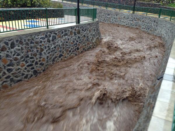
Verklaart ook de grafieken.

[edit]
twitter:PrensaTenerife twitterde op maandag 02-12-2013 om 14:46:59 Cortado el carril de la TF-1 de acceso a Punta Prieta (Güímar) y el enlace completo por #LluviasTenerife. Precaución http://t.co/6wbQxAL8Du reageer retweet
 Cortado el carril de la TF-1 de acceso a Punta Prieta (Güímar) y el enlace completo por
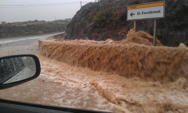
[edit]
twitter:teideano twitterde op maandag 02-12-2013 om 16:57:14 Absolutely amazing rainfall at Tenerife http://t.co/CFIUPdfk1v" reageer retweet
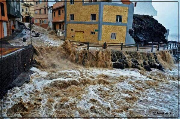
[ Bericht 7% gewijzigd door bwt op 02-12-2013 16:59:22 ]
<a href="http://goo.gl/q8fhTe" target="_blank">FAQ?</a>
<a href="http://goo.gl/gYvZFq" target="_blank">Geel is een zonnige en vrolijke kleur, als hij tenminste enigszins warm is gekleurd en wat naar het oranje neigt</a>
<a href="http://goo.gl/gYvZFq" target="_blank">Geel is een zonnige en vrolijke kleur, als hij tenminste enigszins warm is gekleurd en wat naar het oranje neigt</a>
Laatste foto vorige post:
Sinds 9 uur 's ochtends aan het regenen geweest - op plaatsen tot 200 mm gevallen in 1 dag.
Het is gister kennelijk erg slecht geweest op de canarische eilanden en met name tenerife.twitter:teideano twitterde op maandag 02-12-2013 om 23:36:39 @Missy_Page Tenerife island, about 20 miles from Santa Cruz. reageer retweet
Sinds 9 uur 's ochtends aan het regenen geweest - op plaatsen tot 200 mm gevallen in 1 dag.
twitter:teideano twitterde op maandag 02-12-2013 om 17:24:08 Things are getting worse and worse. Pic: Vicente Bosch. http://t.co/NAqhR3OzFX reageer retweet

twitter:teideano twitterde op maandag 02-12-2013 om 20:03:27 No rain right now, but some models predict a long night here at Tenerife. More than 200mm so far at some spots. http://t.co/vhi1g8CHgR reageer retweet


<a href="http://goo.gl/q8fhTe" target="_blank">FAQ?</a>
<a href="http://goo.gl/gYvZFq" target="_blank">Geel is een zonnige en vrolijke kleur, als hij tenminste enigszins warm is gekleurd en wat naar het oranje neigt</a>
<a href="http://goo.gl/gYvZFq" target="_blank">Geel is een zonnige en vrolijke kleur, als hij tenminste enigszins warm is gekleurd en wat naar het oranje neigt</a>
Nog wat video beelden van het tenerife noodweer

twitter:AlertaMeteo twitterde op vrijdag 06-12-2013 om 20:18:06 Impresionante esta imágen que nos llega desde #Tenerife - #España. Potentes lluvias que ponen en #alerta a la isla. http://t.co/Lb4RXcBw5C reageer retweet
 Impresionante esta imágen que nos llega desde
twitter:teideano twitterde op zaterdag 07-12-2013 om 09:33:56 Another #amazing pic from yesterday #storm at #tenerife. #meteo #weather. Author is Luisma de León. http://t.co/xRwOR7iusR reageer retweet

<a href="http://goo.gl/q8fhTe" target="_blank">FAQ?</a>
<a href="http://goo.gl/gYvZFq" target="_blank">Geel is een zonnige en vrolijke kleur, als hij tenminste enigszins warm is gekleurd en wat naar het oranje neigt</a>
<a href="http://goo.gl/gYvZFq" target="_blank">Geel is een zonnige en vrolijke kleur, als hij tenminste enigszins warm is gekleurd en wat naar het oranje neigt</a>
El-Hierro wise is er niet veel gaande
quote:1249092 08/12/2013 02:23:04 27.7204 -18.0329 12 2.0 mbLg SW FRONTERA.IHI [+]
1249003 07/12/2013 08:12:47 27.7206 -18.0323 11 1.7 mbLg SW FRONTERA.IHI [+]
1248956 06/12/2013 23:18:45 27.6801 -17.9915 20 1.8 mbLg SW EL PINAR.IHI [+]
1248951 06/12/2013 23:00:43 27.7225 -18.0297 12 1.5 mbLg SW FRONTERA.IHI [+]
1248894 06/12/2013 05:33:03 27.7225 -18.0250 12 1.7 mbLg SW FRONTERA.IHI [+]
1248889 06/12/2013 05:09:11 27.7115 -18.0353 13 1.7 mbLg W EL PINAR.IHI [+]
1248547 04/12/2013 04:02:28 27.7486 -18.2499 11 2.2 mbLg W FRONTERA.IHI [+]
1248519 03/12/2013 13:31:50 27.7179 -18.0041 16 1.7 mbLg NW EL PINAR.IHI [+]
1248274 01/12/2013 22:00:20 27.7226 -18.0187 12 II 2.3 mbLg SW FRONTERA.IHI [+]
1248271 01/12/2013 21:10:51 27.7689 -18.0325 23 1.6 mbLg NW FRONTERA.IHI [+]
1248162 30/11/2013 23:04:20 27.7255 -18.0129 10 1.7 mbLg SW FRONTERA.IHI [+]
1248123 30/11/2013 15:47:26 27.7228 -18.0294 12 1.5 mbLg SW FRONTERA.IHI [+]
<a href="http://goo.gl/q8fhTe" target="_blank">FAQ?</a>
<a href="http://goo.gl/gYvZFq" target="_blank">Geel is een zonnige en vrolijke kleur, als hij tenminste enigszins warm is gekleurd en wat naar het oranje neigt</a>
<a href="http://goo.gl/gYvZFq" target="_blank">Geel is een zonnige en vrolijke kleur, als hij tenminste enigszins warm is gekleurd en wat naar het oranje neigt</a>
Inderdaad rustig:
Afgelopen 36 uur:
Afgelopen 15 dagen (wel iets drukker)
Afgelopen 36 uur:

Afgelopen 15 dagen (wel iets drukker)

<a href="http://goo.gl/q8fhTe" target="_blank">FAQ?</a>
<a href="http://goo.gl/gYvZFq" target="_blank">Geel is een zonnige en vrolijke kleur, als hij tenminste enigszins warm is gekleurd en wat naar het oranje neigt</a>
<a href="http://goo.gl/gYvZFq" target="_blank">Geel is een zonnige en vrolijke kleur, als hij tenminste enigszins warm is gekleurd en wat naar het oranje neigt</a>
Het houd nog niet op - het slechte weer op de canarische eilanden
En het zelfde plaatje bij deze twitter post
[edit]
laatste berichtjes naar nieuwe post gezet - zijn van vandaag!!!!
[ Bericht 23% gewijzigd door bwt op 11-12-2013 12:21:38 ]
twitter:teideano twitterde op dinsdag 10-12-2013 om 12:50:53 #meteo #weather Tenerife and La Palma both to expect for torrential rain, up to 60mm in 1 hour. http://t.co/VZoIDvKBL5 reageer retweet

En het zelfde plaatje bij deze twitter post
En ook duidelijk slecht weer op El Hierrotwitter:canariesnews twitterde op dinsdag 10-12-2013 om 19:08:57 New post! La Palma on 'Red Alert' for rain and bad weather - http://t.co/lYAb7LRSjI http://t.co/J2nOIotfvP reageer retweet
 New post! La Palma on 'Red Alert' for rain and bad weather -
 twitter:teideano twitterde op dinsdag 10-12-2013 om 14:11:23 Muelle de La Estaca,El Hierro a las 12.30 #alertacanarias #meteo #weather Foto vía cazatormentas, Arselumaco. http://t.co/LPx71maCuS reageer retweet

[edit]
laatste berichtjes naar nieuwe post gezet - zijn van vandaag!!!!
[ Bericht 23% gewijzigd door bwt op 11-12-2013 12:21:38 ]
<a href="http://goo.gl/q8fhTe" target="_blank">FAQ?</a>
<a href="http://goo.gl/gYvZFq" target="_blank">Geel is een zonnige en vrolijke kleur, als hij tenminste enigszins warm is gekleurd en wat naar het oranje neigt</a>
<a href="http://goo.gl/gYvZFq" target="_blank">Geel is een zonnige en vrolijke kleur, als hij tenminste enigszins warm is gekleurd en wat naar het oranje neigt</a>
En de eerste plaatjes van de storm die over de canarische eilanden raast.
Nog geen week na de vorige storm.
Nog geen week na de vorige storm.
twitter:InfoMeteoTuit twitterde op woensdag 11-12-2013 om 11:01:50 Espectacular rayo cazado al norte de #Tenerife foto Viecente R. Boch vía @MeteoRTVC #Canarias #FMACanarias #Tormenta http://t.co/j3PNs3hDMx reageer retweet
 Espectacular rayo cazado al norte de
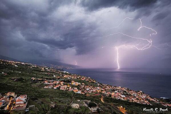
twitter:teideano twitterde op woensdag 11-12-2013 om 11:42:19 Amazing #storm over Tenerife right now. #meteo #weather #nature via @sergiovelascom: Rayo en Observatorio del Teide http://t.co/I1E75QVB8k" reageer retweet
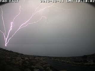
twitter:teideano twitterde op woensdag 11-12-2013 om 11:58:24 Another pic from the storm. #meteo #weather #nature by Carlos Hernandez. http://t.co/11EgQRsq0H reageer retweet

<a href="http://goo.gl/q8fhTe" target="_blank">FAQ?</a>
<a href="http://goo.gl/gYvZFq" target="_blank">Geel is een zonnige en vrolijke kleur, als hij tenminste enigszins warm is gekleurd en wat naar het oranje neigt</a>
<a href="http://goo.gl/gYvZFq" target="_blank">Geel is een zonnige en vrolijke kleur, als hij tenminste enigszins warm is gekleurd en wat naar het oranje neigt</a>
Bezig uurtje.
Zwakke bevingen maar wel duidelijk zichtbaar.
1249759 12/12/2013 05:54:08 27.7096 -18.0273 10 1.5 mbLg W EL PINAR.IHI [+]
1249758 12/12/2013 05:50:11 27.7124 -18.0297 10 1.8 mbLg W EL PINAR.IHI [+]
1249757 12/12/2013 05:22:05 27.7135 -18.0323 11 1.5 mbLg W EL PINAR.IHI [+]
1249756 12/12/2013 05:16:44 27.7172 -18.0308 9 2.1 mbLg W EL PINAR.IHI [+]
1249755 12/12/2013 05:16:32 27.7182 -18.0300 11 2.3 mbLg W EL PINAR.IHI [+]
[ Bericht 13% gewijzigd door bwt op 12-12-2013 13:28:47 ]
Zwakke bevingen maar wel duidelijk zichtbaar.

1249759 12/12/2013 05:54:08 27.7096 -18.0273 10 1.5 mbLg W EL PINAR.IHI [+]
1249758 12/12/2013 05:50:11 27.7124 -18.0297 10 1.8 mbLg W EL PINAR.IHI [+]
1249757 12/12/2013 05:22:05 27.7135 -18.0323 11 1.5 mbLg W EL PINAR.IHI [+]
1249756 12/12/2013 05:16:44 27.7172 -18.0308 9 2.1 mbLg W EL PINAR.IHI [+]
1249755 12/12/2013 05:16:32 27.7182 -18.0300 11 2.3 mbLg W EL PINAR.IHI [+]

[ Bericht 13% gewijzigd door bwt op 12-12-2013 13:28:47 ]
<a href="http://goo.gl/q8fhTe" target="_blank">FAQ?</a>
<a href="http://goo.gl/gYvZFq" target="_blank">Geel is een zonnige en vrolijke kleur, als hij tenminste enigszins warm is gekleurd en wat naar het oranje neigt</a>
<a href="http://goo.gl/gYvZFq" target="_blank">Geel is een zonnige en vrolijke kleur, als hij tenminste enigszins warm is gekleurd en wat naar het oranje neigt</a>
Apparatuur voor de grafieken lijkt een beetje kapot
Metingen staan allemaal op 0.
Mogelijk door het slechte weer van de afgelopen tijd.
Wilt echter niet zeggen dat er niets geregistreerd wordt op andere manieren.
[ Bericht 17% gewijzigd door bwt op 16-12-2013 13:16:48 ]
Metingen staan allemaal op 0.
Mogelijk door het slechte weer van de afgelopen tijd.

Wilt echter niet zeggen dat er niets geregistreerd wordt op andere manieren.
De 2.6 is ook gevoeld op het eilandquote:1250093 14/12/2013 21:42:09 27.7255 -18.0179 13 2.6 mbLg SW FRONTERA.IHI [+]
1250094 14/12/2013 21:40:51 27.7224 -18.0127 12 2.2 mbLg NW EL PINAR.IHI [+]
1250068 14/12/2013 12:59:54 27.7295 -18.0106 9 1.6 mbLg SW FRONTERA.IHI [+]
[ Bericht 17% gewijzigd door bwt op 16-12-2013 13:16:48 ]
<a href="http://goo.gl/q8fhTe" target="_blank">FAQ?</a>
<a href="http://goo.gl/gYvZFq" target="_blank">Geel is een zonnige en vrolijke kleur, als hij tenminste enigszins warm is gekleurd en wat naar het oranje neigt</a>
<a href="http://goo.gl/gYvZFq" target="_blank">Geel is een zonnige en vrolijke kleur, als hij tenminste enigszins warm is gekleurd en wat naar het oranje neigt</a>
Inmidels weer 3 dagen bevingloos
Het 15 daagse overzicht

Het 15 daagse overzicht

<a href="http://goo.gl/q8fhTe" target="_blank">FAQ?</a>
<a href="http://goo.gl/gYvZFq" target="_blank">Geel is een zonnige en vrolijke kleur, als hij tenminste enigszins warm is gekleurd en wat naar het oranje neigt</a>
<a href="http://goo.gl/gYvZFq" target="_blank">Geel is een zonnige en vrolijke kleur, als hij tenminste enigszins warm is gekleurd en wat naar het oranje neigt</a>
[/me]quote:2013-12-18 18:47 UTC
Readers Berry and Leona have told us earlier today that the CHIE graph is alive again. The sensor has however been replaced by the CTIG seismograph.
Only 2 earthquakes since our last update on December 14!
<a href="http://goo.gl/q8fhTe" target="_blank">FAQ?</a>
<a href="http://goo.gl/gYvZFq" target="_blank">Geel is een zonnige en vrolijke kleur, als hij tenminste enigszins warm is gekleurd en wat naar het oranje neigt</a>
<a href="http://goo.gl/gYvZFq" target="_blank">Geel is een zonnige en vrolijke kleur, als hij tenminste enigszins warm is gekleurd en wat naar het oranje neigt</a>
quote:2013-12-21 09:37 UTC
Activity below the island has almost arrived at a standstill as we had only very few earthquakes the last week.
- We have just archived Part 59 of the El Hierro story (we still believe that a new activity period can appear the following days, weeks, months …). Link at the bottom of this page.

<a href="http://goo.gl/q8fhTe" target="_blank">FAQ?</a>
<a href="http://goo.gl/gYvZFq" target="_blank">Geel is een zonnige en vrolijke kleur, als hij tenminste enigszins warm is gekleurd en wat naar het oranje neigt</a>
<a href="http://goo.gl/gYvZFq" target="_blank">Geel is een zonnige en vrolijke kleur, als hij tenminste enigszins warm is gekleurd en wat naar het oranje neigt</a>
Was het gister nog alsof er helemaal niets gebeurde. Vandaag het tegenovergestelde.
Wat er gaande is is nog geheel onbekend
Wel dat er een paar stevige klappers bij zaten.
1251201 22/12/2013 12:16:45 27.7060 -17.9779 16 Sentido 3.2 mbLg S EL PINAR.IHI [+]
En het bevings overzicht
1251217 22/12/2013 16:17:24 27.7370 -17.9525 12 1.9 mbLg NE EL PINAR.IHI [+]
1251216 22/12/2013 16:14:33 27.7224 -17.9645 2.2 mbLg NE EL PINAR.IHI [+]
1251215 22/12/2013 16:05:03 27.7064 -17.9933 17 2.4 mbLg W EL PINAR.IHI [+]
1251214 22/12/2013 15:46:51 27.7114 -17.9841 17 2.5 mbLg NW EL PINAR.IHI [+]
1251213 22/12/2013 15:39:53 27.7213 -17.9759 14 2.1 mbLg N EL PINAR.IHI [+]
1251212 22/12/2013 15:24:38 27.7003 -17.9728 15 2.7 mbLg SE EL PINAR.IHI [+]
1251211 22/12/2013 15:12:14 27.7107 -17.9807 17 2.6 mbLg NW EL PINAR.IHI [+]
1251210 22/12/2013 14:57:56 27.7220 -17.9768 16 2.4 mbLg N EL PINAR.IHI [+]
1251209 22/12/2013 14:42:38 27.7161 -17.9591 2.1 mbLg NE EL PINAR.IHI [+]
1251207 22/12/2013 14:30:23 27.7017 -17.9891 19 2.7 mbLg SW EL PINAR.IHI [+]
1251202 22/12/2013 13:00:29 27.7130 -17.9713 15 2.3 mbLg NE EL PINAR.IHI [+]
1251201 22/12/2013 12:16:45 27.7060 -17.9779 16 Sentido 3.2 mbLg S EL PINAR.IHI [+]
1251197 22/12/2013 10:51:02 27.7056 -17.9880 17 2.8 mbLg W EL PINAR.IHI [+]
1251183 22/12/2013 08:27:40 27.7200 -17.9887 16 1.9 mbLg NW EL PINAR.IHI [+]
1251182 22/12/2013 07:36:55 27.7483 -17.9916 17 2.2 mbLg SE FRONTERA.IHI [+]
1251161 22/12/2013 05:41:45 27.7729 -18.0179 17 1.6 mbLg NW FRONTERA.IHI [+]
1251159 22/12/2013 04:27:07 27.7762 -18.0156 16 1.5 mbLg NW FRONTERA.IHI [+]
1251158 22/12/2013 04:08:02 27.7827 -18.0249 14 2.1 mbLg NW FRONTERA.IHI [+]
1251157 22/12/2013 04:01:05 27.7580 -18.0322 16 2.4 mbLg W FRONTERA.IHI [+]
1251156 22/12/2013 03:18:49 27.6514 -17.9980 16 1.7 mbLg SW EL PINAR.IHI [+]
1251155 22/12/2013 03:16:48 27.7525 -18.0334 15 2.0 mbLg W FRONTERA.IHI [+]
1251135 22/12/2013 02:32:11 27.7954 -18.0464 15 1.5 mbLg NW FRONTERA.IHI [+]
1251133 22/12/2013 01:55:38 27.8217 -18.0448 13 1.8 mbLg NW FRONTERA.IHI [+]
1251132 22/12/2013 01:43:52 27.8079 -18.0529 16 1.6 mbLg NW FRONTERA.IHI [+]
1251131 22/12/2013 01:42:54 27.7964 -18.0458 16 1.8 mbLg NW FRONTERA.IHI [+]
1251129 22/12/2013 01:42:24 27.8139 -18.0501 15 2.1 mbLg NW FRONTERA.IHI [+]
[ Bericht 3% gewijzigd door bwt op 22-12-2013 18:10:43 ]
Wat er gaande is is nog geheel onbekend
Wel dat er een paar stevige klappers bij zaten.
1251201 22/12/2013 12:16:45 27.7060 -17.9779 16 Sentido 3.2 mbLg S EL PINAR.IHI [+]
quote:2013-12-22 09:21 UTC
A sudden increase of seismicity. Too soon to talk about a new crisis, but with 5 2+ Magnitude earthquakes on 13 quakes, this looks to be more than the usual small -M1 quakes we have seen the recent weeks. (Thank You Leona for alerting us).
Stronger earthquakes are within reach today.
Most epicenters are located in the El Golfo area and some of them may even have been felt by people living in Frontera.
The depth is normal for all beginning activity. As long as the hypocenters (breaking point generating the earthquakes) is not below 10 km, looking for an eruptive episode is not realistic.
Shaking from earthquakes is starting to be dangerous from M3 on for landslides (steep cliffs area) and from M4 on for structures (mainly cracks in walls and NOT collapsed houses).
2013-12-22 10:22 UTC
The seismograph screenshot from La Restinga shows the current activity. Apart from the listed earthquakes, we also see a lot of micro-seismicity (mainly by comparing the graphs from the past days). Please note that most of the oscillations are coming from human triggered events (seismographs are very sensitive). The thicker tremor line started however when seismicity increased.
2013-12-22 15:20 UTC
As said in our prior updates a magma intrusion is currently going on below El Hierro. So far the strongest earthquake is a M3.2 at 12:16. Stronger earthquakes may be expected. The depth remains at a safe level.


twitter:teideano twitterde op zondag 22-12-2013 om 16:39:13 Seismicity at El Hierro is back again, up to 3,2M 20 quakes so far today. #nature #volcano #geology http://t.co/9QQUE3a1Vs maps available reageer retweet
twitter:teideano twitterde op zondag 22-12-2013 om 17:01:06 Ultimo terremoto localizado en El Hierro a travès de la #app Avcan Quake http://t.co/1TOiyC3pmE reageer retweet
twitter:teideano twitterde op zondag 22-12-2013 om 17:03:31 Otro terremoto más localizado en El Hierro M2.7 con la #app Avcan Quake. Día de actividad importante. http://t.co/ef6p99kjLX reageer retweet
twitter:teideano twitterde op zondag 22-12-2013 om 17:36:54 Otros 4 terremotos más en El Hierro. imagen del ùltimo de ellos, de M2,2 a travès de la #app Avcan Quake. http://t.co/ogSnrRj7Qf reageer retweet

En het bevings overzicht
1251217 22/12/2013 16:17:24 27.7370 -17.9525 12 1.9 mbLg NE EL PINAR.IHI [+]
1251216 22/12/2013 16:14:33 27.7224 -17.9645 2.2 mbLg NE EL PINAR.IHI [+]
1251215 22/12/2013 16:05:03 27.7064 -17.9933 17 2.4 mbLg W EL PINAR.IHI [+]
1251214 22/12/2013 15:46:51 27.7114 -17.9841 17 2.5 mbLg NW EL PINAR.IHI [+]
1251213 22/12/2013 15:39:53 27.7213 -17.9759 14 2.1 mbLg N EL PINAR.IHI [+]
1251212 22/12/2013 15:24:38 27.7003 -17.9728 15 2.7 mbLg SE EL PINAR.IHI [+]
1251211 22/12/2013 15:12:14 27.7107 -17.9807 17 2.6 mbLg NW EL PINAR.IHI [+]
1251210 22/12/2013 14:57:56 27.7220 -17.9768 16 2.4 mbLg N EL PINAR.IHI [+]
1251209 22/12/2013 14:42:38 27.7161 -17.9591 2.1 mbLg NE EL PINAR.IHI [+]
1251207 22/12/2013 14:30:23 27.7017 -17.9891 19 2.7 mbLg SW EL PINAR.IHI [+]
1251202 22/12/2013 13:00:29 27.7130 -17.9713 15 2.3 mbLg NE EL PINAR.IHI [+]
1251201 22/12/2013 12:16:45 27.7060 -17.9779 16 Sentido 3.2 mbLg S EL PINAR.IHI [+]
1251197 22/12/2013 10:51:02 27.7056 -17.9880 17 2.8 mbLg W EL PINAR.IHI [+]
1251183 22/12/2013 08:27:40 27.7200 -17.9887 16 1.9 mbLg NW EL PINAR.IHI [+]
1251182 22/12/2013 07:36:55 27.7483 -17.9916 17 2.2 mbLg SE FRONTERA.IHI [+]
1251161 22/12/2013 05:41:45 27.7729 -18.0179 17 1.6 mbLg NW FRONTERA.IHI [+]
1251159 22/12/2013 04:27:07 27.7762 -18.0156 16 1.5 mbLg NW FRONTERA.IHI [+]
1251158 22/12/2013 04:08:02 27.7827 -18.0249 14 2.1 mbLg NW FRONTERA.IHI [+]
1251157 22/12/2013 04:01:05 27.7580 -18.0322 16 2.4 mbLg W FRONTERA.IHI [+]
1251156 22/12/2013 03:18:49 27.6514 -17.9980 16 1.7 mbLg SW EL PINAR.IHI [+]
1251155 22/12/2013 03:16:48 27.7525 -18.0334 15 2.0 mbLg W FRONTERA.IHI [+]
1251135 22/12/2013 02:32:11 27.7954 -18.0464 15 1.5 mbLg NW FRONTERA.IHI [+]
1251133 22/12/2013 01:55:38 27.8217 -18.0448 13 1.8 mbLg NW FRONTERA.IHI [+]
1251132 22/12/2013 01:43:52 27.8079 -18.0529 16 1.6 mbLg NW FRONTERA.IHI [+]
1251131 22/12/2013 01:42:54 27.7964 -18.0458 16 1.8 mbLg NW FRONTERA.IHI [+]
1251129 22/12/2013 01:42:24 27.8139 -18.0501 15 2.1 mbLg NW FRONTERA.IHI [+]
[ Bericht 3% gewijzigd door bwt op 22-12-2013 18:10:43 ]
<a href="http://goo.gl/q8fhTe" target="_blank">FAQ?</a>
<a href="http://goo.gl/gYvZFq" target="_blank">Geel is een zonnige en vrolijke kleur, als hij tenminste enigszins warm is gekleurd en wat naar het oranje neigt</a>
<a href="http://goo.gl/gYvZFq" target="_blank">Geel is een zonnige en vrolijke kleur, als hij tenminste enigszins warm is gekleurd en wat naar het oranje neigt</a>
Het is nog te vroeg om iets zinnigs te roepen over wat er gaande is.
Er is geen indicatie dat het eiland weer aan het groeien / verplaatsen is zoals bij de vorige activiteiten
Zag het er gister nog zo uit:
Vandaag is het duidelijk drukker
En waar waren de bevingen dan?
Afgelopen 36 uur:
En de afgelopen 15 dagen
En hoe druk was het tussen 16-17 uur
1251219 22/12/2013 16:34:32 27.7324 -17.9685 15 2.7 mbLg NE EL PINAR.IHI [+]
1251218 22/12/2013 16:31:51 27.7129 -17.9932 18 Sentido 3.1 mbLg NW EL PINAR.IHI [+]
De onderste is omhoog geschaald van 3.0 naar 3.1
Mogelijk gaat de bovenste van de 3 ook nog omhoog.
[edit]
Yep, van 3.1 naar 3.2
Activiteit lijkt af te nemen
[ Bericht 8% gewijzigd door bwt op 22-12-2013 18:29:30 ]
Er is geen indicatie dat het eiland weer aan het groeien / verplaatsen is zoals bij de vorige activiteiten
Zag het er gister nog zo uit:

Vandaag is het duidelijk drukker

En waar waren de bevingen dan?
Afgelopen 36 uur:

En de afgelopen 15 dagen

En hoe druk was het tussen 16-17 uur

1251220 22/12/2013 16:34:52 27.7220 -17.9726 17 Sentido 3.2 mbLg NE EL PINAR.IHI [+]twitter:
1251219 22/12/2013 16:34:32 27.7324 -17.9685 15 2.7 mbLg NE EL PINAR.IHI [+]
1251218 22/12/2013 16:31:51 27.7129 -17.9932 18 Sentido 3.1 mbLg NW EL PINAR.IHI [+]
De onderste is omhoog geschaald van 3.0 naar 3.1
Mogelijk gaat de bovenste van de 3 ook nog omhoog.
[edit]
Yep, van 3.1 naar 3.2
Activiteit lijkt af te nemen

[ Bericht 8% gewijzigd door bwt op 22-12-2013 18:29:30 ]
<a href="http://goo.gl/q8fhTe" target="_blank">FAQ?</a>
<a href="http://goo.gl/gYvZFq" target="_blank">Geel is een zonnige en vrolijke kleur, als hij tenminste enigszins warm is gekleurd en wat naar het oranje neigt</a>
<a href="http://goo.gl/gYvZFq" target="_blank">Geel is een zonnige en vrolijke kleur, als hij tenminste enigszins warm is gekleurd en wat naar het oranje neigt</a>
Hahahaha,quote:
Hier dan een mooie van meteo consult / weer.nl
twitter:MeteoConsult twitterde op zaterdag 21-12-2013 om 07:34:31 Een kerstboom gesignaleerd in de neerslagpluim voor eerste kerstdag..... Oei.. dat wordt veel regen. http://t.co/zjIx5PIPmS reageer retweet
 Een kerstboom gesignaleerd in de neerslagpluim voor eerste kerstdag..... Oei.. dat wordt veel regen.
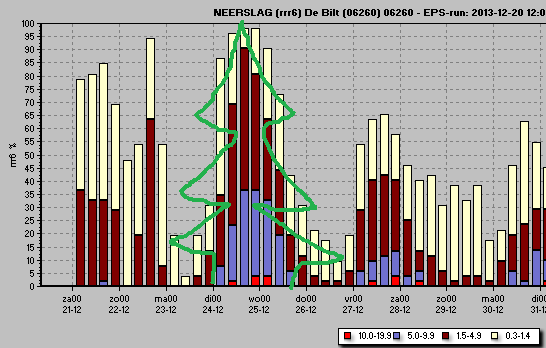
<a href="http://goo.gl/q8fhTe" target="_blank">FAQ?</a>
<a href="http://goo.gl/gYvZFq" target="_blank">Geel is een zonnige en vrolijke kleur, als hij tenminste enigszins warm is gekleurd en wat naar het oranje neigt</a>
<a href="http://goo.gl/gYvZFq" target="_blank">Geel is een zonnige en vrolijke kleur, als hij tenminste enigszins warm is gekleurd en wat naar het oranje neigt</a>
Het is wel wat afgezwakt inmiddels.
1251287 22/12/2013 23:58:49 27.7125 -17.9795 1.8 mbLg NW EL PINAR.IHI [+]
1251286 22/12/2013 23:55:35 27.7129 -17.9688 1.9 mbLg NE EL PINAR.IHI [+]
1251285 22/12/2013 23:43:55 27.7120 -17.9750 16 2.1 mbLg NE EL PINAR.IHI [+]
1251284 22/12/2013 23:36:48 27.7061 -17.9767 18 2.4 mbLg SE EL PINAR.IHI [+]
1251282 22/12/2013 23:30:45 27.7062 -17.9788 16 2.9 mbLg SW EL PINAR.IHI [+]
1251281 22/12/2013 23:29:32 27.7079 -17.9920 18 2.7 mbLg W EL PINAR.IHI [+]
1251279 22/12/2013 23:13:14 27.7246 -17.9774 15 2.2 mbLg N EL PINAR.IHI [+]
1251278 22/12/2013 23:05:22 27.7175 -17.9742 18 2.3 mbLg NE EL PINAR.IHI [+]
1251277 22/12/2013 23:01:31 27.7352 -17.9747 20 1.8 mbLg N EL PINAR.IHI [+]
1251276 22/12/2013 22:54:50 27.7111 -17.9873 15 1.6 mbLg NW EL PINAR.IHI [+]
1251274 22/12/2013 22:51:34 27.7178 -17.9907 16 2.1 mbLg NW EL PINAR.IHI [+]
1251273 22/12/2013 22:44:08 27.7134 -17.9670 2.6 mbLg NE EL PINAR.IHI [+]
1251272 22/12/2013 22:35:17 27.6785 -18.0140 31 2.3 mbLg SW EL PINAR.IHI [+]
1251271 22/12/2013 22:30:17 27.7034 -17.9846 16 2.7 mbLg SW EL PINAR.IHI [+]
1251270 22/12/2013 22:26:07 27.7060 -17.9851 2.4 mbLg SW EL PINAR.IHI [+]
1251269 22/12/2013 22:25:38 27.7030 -17.9888 17 2.5 mbLg SW EL PINAR.IHI [+]
1251265 22/12/2013 22:17:15 27.7081 -17.9806 1.7 mbLg W EL PINAR.IHI [+]
1251263 22/12/2013 22:08:09 27.7089 -17.9791 15 2.2 mbLg NW EL PINAR.IHI [+]
1251262 22/12/2013 22:03:38 27.7062 -17.9855 17 2.3 mbLg SW EL PINAR.IHI [+]
1251261 22/12/2013 21:54:57 27.7163 -17.9764 17 2.1 mbLg NE EL PINAR.IHI [+]
1251260 22/12/2013 21:54:22 27.7285 -17.9842 16 2.0 mbLg NW EL PINAR.IHI [+]
1251245 22/12/2013 19:11:34 27.7170 -17.9579 16 1.6 mbLg NE EL PINAR.IHI [+]
1251246 22/12/2013 18:56:49 27.7198 -17.9581 16 1.8 mbLg NE EL PINAR.IHI [+]
1251243 22/12/2013 18:53:47 27.7022 -17.9703 17 1.5 mbLg SE EL PINAR.IHI [+]
1251241 22/12/2013 18:50:30 27.7272 -17.9563 17 1.5 mbLg NE EL PINAR.IHI [+]
1251240 22/12/2013 18:47:34 27.7268 -17.9524 16 1.6 mbLg NE EL PINAR.IHI [+]
1251236 22/12/2013 18:25:13 27.7267 -17.9624 17 1.8 mbLg NE EL PINAR.IHI [+]
1251234 22/12/2013 18:22:31 27.7162 -17.9528 15 2.0 mbLg NE EL PINAR.IHI [+]
1251234 22/12/2013 18:22:31 27.7162 -17.9528 15 2.0 mbLg NE EL PINAR.IHI [+]
1251233 22/12/2013 18:19:22 27.7302 -17.9769 21 2.0 mbLg N EL PINAR.IHI [+]
1251230 22/12/2013 17:55:03 27.7232 -17.9806 15 2.4 mbLg N EL PINAR.IHI [+]
1251232 22/12/2013 17:39:41 27.7254 -17.9736 17 2.0 mbLg N EL PINAR.IHI [+]
1251229 22/12/2013 17:11:25 27.7185 -17.9605 16 1.5 mbLg NE EL PINAR.IHI [+]
1251225 22/12/2013 17:07:43 27.7279 -17.9818 16 2.0 mbLg N EL PINAR.IHI [+]
1251227 22/12/2013 17:04:14 27.7273 -17.9580 15 1.7 mbLg NE EL PINAR.IHI [+]
1251228 22/12/2013 16:56:58 27.7236 -17.9636 14 1.5 mbLg NE EL PINAR.IHI [+]
[ Bericht 22% gewijzigd door bwt op 23-12-2013 10:04:19 ]
1251287 22/12/2013 23:58:49 27.7125 -17.9795 1.8 mbLg NW EL PINAR.IHI [+]
1251286 22/12/2013 23:55:35 27.7129 -17.9688 1.9 mbLg NE EL PINAR.IHI [+]
1251285 22/12/2013 23:43:55 27.7120 -17.9750 16 2.1 mbLg NE EL PINAR.IHI [+]
1251284 22/12/2013 23:36:48 27.7061 -17.9767 18 2.4 mbLg SE EL PINAR.IHI [+]
1251282 22/12/2013 23:30:45 27.7062 -17.9788 16 2.9 mbLg SW EL PINAR.IHI [+]
1251281 22/12/2013 23:29:32 27.7079 -17.9920 18 2.7 mbLg W EL PINAR.IHI [+]
1251279 22/12/2013 23:13:14 27.7246 -17.9774 15 2.2 mbLg N EL PINAR.IHI [+]
1251278 22/12/2013 23:05:22 27.7175 -17.9742 18 2.3 mbLg NE EL PINAR.IHI [+]
1251277 22/12/2013 23:01:31 27.7352 -17.9747 20 1.8 mbLg N EL PINAR.IHI [+]
1251276 22/12/2013 22:54:50 27.7111 -17.9873 15 1.6 mbLg NW EL PINAR.IHI [+]
1251274 22/12/2013 22:51:34 27.7178 -17.9907 16 2.1 mbLg NW EL PINAR.IHI [+]
1251273 22/12/2013 22:44:08 27.7134 -17.9670 2.6 mbLg NE EL PINAR.IHI [+]
1251272 22/12/2013 22:35:17 27.6785 -18.0140 31 2.3 mbLg SW EL PINAR.IHI [+]
1251271 22/12/2013 22:30:17 27.7034 -17.9846 16 2.7 mbLg SW EL PINAR.IHI [+]
1251270 22/12/2013 22:26:07 27.7060 -17.9851 2.4 mbLg SW EL PINAR.IHI [+]
1251269 22/12/2013 22:25:38 27.7030 -17.9888 17 2.5 mbLg SW EL PINAR.IHI [+]
1251265 22/12/2013 22:17:15 27.7081 -17.9806 1.7 mbLg W EL PINAR.IHI [+]
1251263 22/12/2013 22:08:09 27.7089 -17.9791 15 2.2 mbLg NW EL PINAR.IHI [+]
1251262 22/12/2013 22:03:38 27.7062 -17.9855 17 2.3 mbLg SW EL PINAR.IHI [+]
1251261 22/12/2013 21:54:57 27.7163 -17.9764 17 2.1 mbLg NE EL PINAR.IHI [+]
1251260 22/12/2013 21:54:22 27.7285 -17.9842 16 2.0 mbLg NW EL PINAR.IHI [+]
1251245 22/12/2013 19:11:34 27.7170 -17.9579 16 1.6 mbLg NE EL PINAR.IHI [+]
1251246 22/12/2013 18:56:49 27.7198 -17.9581 16 1.8 mbLg NE EL PINAR.IHI [+]
1251243 22/12/2013 18:53:47 27.7022 -17.9703 17 1.5 mbLg SE EL PINAR.IHI [+]
1251241 22/12/2013 18:50:30 27.7272 -17.9563 17 1.5 mbLg NE EL PINAR.IHI [+]
1251240 22/12/2013 18:47:34 27.7268 -17.9524 16 1.6 mbLg NE EL PINAR.IHI [+]
1251236 22/12/2013 18:25:13 27.7267 -17.9624 17 1.8 mbLg NE EL PINAR.IHI [+]
1251234 22/12/2013 18:22:31 27.7162 -17.9528 15 2.0 mbLg NE EL PINAR.IHI [+]
1251234 22/12/2013 18:22:31 27.7162 -17.9528 15 2.0 mbLg NE EL PINAR.IHI [+]
1251233 22/12/2013 18:19:22 27.7302 -17.9769 21 2.0 mbLg N EL PINAR.IHI [+]
1251230 22/12/2013 17:55:03 27.7232 -17.9806 15 2.4 mbLg N EL PINAR.IHI [+]
1251232 22/12/2013 17:39:41 27.7254 -17.9736 17 2.0 mbLg N EL PINAR.IHI [+]
1251229 22/12/2013 17:11:25 27.7185 -17.9605 16 1.5 mbLg NE EL PINAR.IHI [+]
1251225 22/12/2013 17:07:43 27.7279 -17.9818 16 2.0 mbLg N EL PINAR.IHI [+]
1251227 22/12/2013 17:04:14 27.7273 -17.9580 15 1.7 mbLg NE EL PINAR.IHI [+]
1251228 22/12/2013 16:56:58 27.7236 -17.9636 14 1.5 mbLg NE EL PINAR.IHI [+]
quote:2013-12-22 19:44 UTC
Our opinion written during the first update this morning became true, a new magma intrusion is occurring below the island. Some people are so excited about the new activity that they are spreading some kind of minor panic. We emphasise that IGN did a great job in following up all other crisis and that they are standby 24 hours a day. The location were they are watching the instruments (Madrid or El Hierro) is totally unimportant at this moment. The earthquakes are still in average in between 13 and 15 km with NO fast progression to a shallower depth. IGN will increase the number of instruments (some were apparently broken after the bad weather) and will certainly be replaced.
We will of course NOT comment on every earthquake BUT we are following up what happens and will report asap when something new and relevant is happening (as you now of course).
- The activity as it started this morning is intensifying. Nobody knows what wille happen the next minute, hour, day or week. It can suddenly stop or it can continue.If it continues we expect even stronger earthquakes than the ones so far, this based on earlier crisis. Good to repeat that only earthquakes (below first 10 km and later 5 km) will throw another light on the current situation.
- 41 earthquakes so far today IGN reports 4 felt by the islanders but we think there are more felt, but only 4 reported at IGN.
- The epicenters of the last 10 earthquakes are mainly at the eastern part of the island, a totally other section than the one earlier activity was noted. This brings a new uncertainty in the field as we do not know the resistance of this part (we know it from other parts).
- The intrusion has calmed down since a couple of hours (see the tremor line below getting thinner, but a new strong quake can change everything again pressure building up until it breaks). Do not hesitate to comment on the bottom of this page if the people following this activity are seeing something strange again. A 0 depth is (by the way) in 99.9% of the cases an instrument error).
- Something relaxing for our friends at the US and South-American East coast : We know that a lot of people are fearing a collapse of the island, but what is happening today occurs at the opposite end of the island.
[ Bericht 22% gewijzigd door bwt op 23-12-2013 10:04:19 ]
<a href="http://goo.gl/q8fhTe" target="_blank">FAQ?</a>
<a href="http://goo.gl/gYvZFq" target="_blank">Geel is een zonnige en vrolijke kleur, als hij tenminste enigszins warm is gekleurd en wat naar het oranje neigt</a>
<a href="http://goo.gl/gYvZFq" target="_blank">Geel is een zonnige en vrolijke kleur, als hij tenminste enigszins warm is gekleurd en wat naar het oranje neigt</a>
En het gaat vandaag weer verder
1251377 23/12/2013 07:50:09 27.7073 -17.9886 17 2.0 mbLg W EL PINAR.IHI [+]
1251366 23/12/2013 07:38:06 27.7071 -17.9843 16 2.2 mbLg W EL PINAR.IHI [+]
1251378 23/12/2013 07:32:05 27.7119 -17.9856 17 2.1 mbLg NW EL PINAR.IHI [+]
1251375 23/12/2013 07:25:35 27.7094 -17.9988 18 2.3 mbLg W EL PINAR.IHI [+]
1251355 23/12/2013 07:19:21 27.7076 -17.9945 16 2.4 mbLg W EL PINAR.IHI [+]
1251373 23/12/2013 07:15:06 27.7227 -17.9903 16 1.7 mbLg NW EL PINAR.IHI [+]
1251372 23/12/2013 07:00:40 27.7047 -17.9863 17 2.5 mbLg SW EL PINAR.IHI [+]
1251371 23/12/2013 06:59:18 27.7062 -17.9858 16 2.0 mbLg SW EL PINAR.IHI [+]
1251369 23/12/2013 06:57:10 27.7484 -18.0094 15 1.6 mbLg SW FRONTERA.IHI [+]
1251364 23/12/2013 06:40:38 27.7068 -17.9891 17 2.6 mbLg W EL PINAR.IHI [+]
1251363 23/12/2013 06:35:13 27.7204 -17.9824 16 2.6 mbLg NW EL PINAR.IHI [+]
1251362 23/12/2013 06:29:53 27.7136 -17.9760 15 2.2 mbLg NE EL PINAR.IHI [+]
1251361 23/12/2013 06:20:04 27.7077 -17.9750 14 2.1 mbLg E EL PINAR.IHI [+]
1251359 23/12/2013 06:18:49 27.7054 -17.9795 14 2.3 mbLg SW EL PINAR.IHI [+]
1251360 23/12/2013 06:10:00 27.7092 -17.9679 16 2.0 mbLg E EL PINAR.IHI [+]
1251353 23/12/2013 05:58:26 27.7062 -17.9823 16 2.0 mbLg SW EL PINAR.IHI [+]
1251352 23/12/2013 05:56:40 27.7061 -17.9842 17 1.9 mbLg SW EL PINAR.IHI [+]
1251351 23/12/2013 05:54:08 27.7183 -17.9845 14 1.7 mbLg NW EL PINAR.IHI [+]
1251349 23/12/2013 05:52:04 27.7129 -17.9689 15 1.8 mbLg NE EL PINAR.IHI [+]
1251348 23/12/2013 05:47:57 27.7283 -17.9892 16 1.9 mbLg NW EL PINAR.IHI [+]
1251347 23/12/2013 05:38:52 27.7041 -17.9859 16 2.1 mbLg SW EL PINAR.IHI [+]
1251320 23/12/2013 05:38:06 27.7046 -17.9815 16 2.7 mbLg SW EL PINAR.IHI [+]
1251346 23/12/2013 05:31:07 27.7087 -17.9843 15 2.2 mbLg W EL PINAR.IHI [+]
1251344 23/12/2013 05:15:36 27.7290 -17.9882 15 2.8 mbLg NW EL PINAR.IHI [+]
1251343 23/12/2013 05:08:47 27.7098 -17.9918 19 1.8 mbLg W EL PINAR.IHI [+]
1251319 23/12/2013 04:49:59 27.7103 -17.9802 15 2.6 mbLg NW EL PINAR.IHI [+]
1251318 23/12/2013 04:45:26 27.7126 -17.9965 19 2.2 mbLg W EL PINAR.IHI [+]
1251317 23/12/2013 04:37:59 27.7120 -17.9738 16 2.5 mbLg NE EL PINAR.IHI [+]
1251316 23/12/2013 04:24:26 27.7047 -17.9823 16 2.8 mbLg SW EL PINAR.IHI [+]
1251315 23/12/2013 04:13:59 27.7285 -18.0024 16 2.1 mbLg S FRONTERA.IHI [+]
1251308 23/12/2013 03:52:27 27.7214 -17.9878 18 2.1 mbLg NW EL PINAR.IHI [+]
1251307 23/12/2013 03:44:59 27.7128 -17.9902 18 2.2 mbLg NW EL PINAR.IHI [+]
1251306 23/12/2013 03:31:08 27.7067 -17.9917 17 2.5 mbLg W EL PINAR.IHI [+]
1251303 23/12/2013 03:13:30 27.7240 -17.9890 17 2.0 mbLg NW EL PINAR.IHI [+]
1251302 23/12/2013 02:57:10 27.7293 -17.9967 16 2.0 mbLg NW EL PINAR.IHI [+]
1251301 23/12/2013 02:13:50 27.7265 -17.9876 17 2.1 mbLg NW EL PINAR.IHI [+]
1251300 23/12/2013 01:53:38 27.7282 -17.9785 15 Sentido 2.7 mbLg N EL PINAR.IHI [+]
1251299 23/12/2013 01:36:28 27.7252 -17.9916 17 2.6 mbLg NW EL PINAR.IHI [+]
1251298 23/12/2013 01:27:39 27.7224 -17.9962 18 2.4 mbLg NW EL PINAR.IHI [+]
1251297 23/12/2013 01:23:56 27.7123 -17.9706 1.6 mbLg NE EL PINAR.IHI [+]
1251296 23/12/2013 01:16:23 27.7045 -17.9801 16 2.7 mbLg SW EL PINAR.IHI [+]
1251295 23/12/2013 01:07:42 27.7063 -17.9880 16 2.4 mbLg W EL PINAR.IHI [+]
1251294 23/12/2013 00:51:38 27.7027 -17.9795 18 2.0 mbLg SW EL PINAR.IHI [+]
1251293 23/12/2013 00:45:29 27.7038 -17.9816 16 2.2 mbLg SW EL PINAR.IHI [+]
1251291 23/12/2013 00:20:09 27.7145 -17.9774 1.8 mbLg N EL PINAR.IHI [+]
1251289 23/12/2013 00:15:30 27.7520 -18.0015 17 Sentido 3.1 mbLg SW FRONTERA.IHI [+]
1251292 23/12/2013 00:11:21 27.7047 -17.9867 17 2.5 mbLg SW EL PINAR.IHI [+]
1251290 23/12/2013 00:10:33 27.6981 -17.9928 20 2.2 mbLg SW EL PINAR.IHI [+]
1251288 23/12/2013 00:09:52 27.7077 -17.9853 17 2.6 mbLg W EL PINAR.IHI [+]
Het zit erg sterk op 1 plek

<a href="http://goo.gl/q8fhTe" target="_blank">FAQ?</a>
<a href="http://goo.gl/gYvZFq" target="_blank">Geel is een zonnige en vrolijke kleur, als hij tenminste enigszins warm is gekleurd en wat naar het oranje neigt</a>
<a href="http://goo.gl/gYvZFq" target="_blank">Geel is een zonnige en vrolijke kleur, als hij tenminste enigszins warm is gekleurd en wat naar het oranje neigt</a>
Bevingen blijven erg actief.
De tremor die er gister even te zien is geweest is inmiddels aal weer weg.
De bevingen van de afgelopen 36 uur
Volgens ER is eer ook weer een up-lift van verschillende delen van het eiland
[ Bericht 40% gewijzigd door bwt op 23-12-2013 20:16:03 ]
De tremor die er gister even te zien is geweest is inmiddels aal weer weg.
De bevingen van de afgelopen 36 uur

Volgens ER is eer ook weer een up-lift van verschillende delen van het eiland

quote:2013-12-23 08:49 UTC
- Confirmation of the current Magma thrust below the island comes from the deformation data from Involcan University of Nagoya (Prof. Sagiya) El Pinar GPS station. The thrust has led to an upwards deformation of at least 2 cm (Ultra Rapid data, to be confirmed later). De deformation to the North-East is less than a cm.
quote:2013-12-23 13:28 UTC
- Involcan (Nemesio Perez) and IGN (Carmen Lopez) are saying the same as we have done since the beginning yesterday
- 58 earthquakes listed by IGN so far today
- Location last earthquakes (El Pinar area) = unchanged
- Hypocenter depth : 15 to 18 km = unchanged
2013-12-23 09:32 UTC
- If you live in El Pinar, you do want to see the epicenter of the last set of earthquakes below. Almost all the current seismicity is concentrated in the direct El Pinar area (red squares). The initial earthquakes started in the El Golfo area (green squares are the older quakes). But, we repeat, at the current depth there is no immediate risk. If IGN would see any danger, they will act swiftly (we are convinced about that). As stronger earthquakes are expected we would advise people living in El Pinar to read our Be Earthquake Prepared section
quote:2013-12-23 18:02 UTC
- We just had contact with Joke Volta who lives in El Pinar, exactly the area with all the current epicenters. She said that she felt nothing important, just some light shaking now and then.
- If we look at the IGN deformation graphs (see below), 4 GPS stations are showing lifting deformations of around 2 cm HI08 is normal of course (the current epicenter area), but Hi09 (La Restinga part of the island), FRON (Frontera) and HI02 (El Golfo) who have almost the same upper deformation. All other stations on the island remain unchanged (please note that HI10, also on the lifting axe, has stopped reporting earlier this year).
- 99 earthquakes so far today !
[ Bericht 40% gewijzigd door bwt op 23-12-2013 20:16:03 ]
<a href="http://goo.gl/q8fhTe" target="_blank">FAQ?</a>
<a href="http://goo.gl/gYvZFq" target="_blank">Geel is een zonnige en vrolijke kleur, als hij tenminste enigszins warm is gekleurd en wat naar het oranje neigt</a>
<a href="http://goo.gl/gYvZFq" target="_blank">Geel is een zonnige en vrolijke kleur, als hij tenminste enigszins warm is gekleurd en wat naar het oranje neigt</a>
quote:El Hierro (Canary Islands, Spain): The new earthquake swarm that started under the island yesterday continues with now more than 100 quakes above magnitude 2 and several in the magnitude 3 range that were weakly felt on the island in some areas. The earthquakes are located at about 15 km depth under the southeastern central part of the island. Slight inflation is visible as well, suggesting that a new episode of magma inflation beneath the crust of the island has started. Whether or not this could lead to a new eruption is impossible to predict, but the most recent such episodes in the past 2 years occurred with no eruption following.
quote:2013-12-24 09:50 UTC
- Relatively few earthquakes today (less than yesterday)
- some information for both ends of readers. Those on the island who merely want to live their safe live and want to enjoy tourist spending : less earthquakes. Those (almost all from other places in the world : it is not over yet.
- The seismograph image below shows a strong earthquake at 06:17. If you are looking in the list for this earthquake, you will be surprised that it is only a 2.4 Magnitude. Why such a big line on the graph then? Because of the depth of 9 km. The seismograph is the confirmation that the depth must have been true (in seismology error margins are normal – in preliminary readings).
- Some activity is taking place offshore at the east of the island.
- Magma wint gradually into a more shallow layer. It went up approx. 2 km (from 15 to 17 km towards 12 to 15 km (last 5 earthquakes).
- The seismograph image shows at the end some more tremor indicating a further intrusion of magma. These quakes are not yet showed on the list.
- De El Pinar GPS deformation data is showing a Northern deformation of nearly 2 cm. More lifting of a bout 1 cm.
- The IGN deformation data are showing a further lifting of 2 cm! on the HI09 (La Restinga) GPS and a 1 cm lifting of the El Pinar HI08 GPS. this means lesser lifting in El Pinar and more lifting in La Restinga than the prior 24 hours. These readings are confirming what we see on the seismicity map.
- In terms of safety on the short term, we are convinced that a PEVOLCA will meet soon and will publish a report afterwards. (PEVOLCA safety board of the island consisting of IGN, INVOLCAN and the local and national authorities)

Activiteit lijkt wel sterk af te nemen.
Maar je weet het nooit
Deze beving valt op door de diepte van 9 KM
1251611 24/12/2013 06:17:26 27.6591 -17.9395 9 2.4 4 SE EL PINAR.IHI


En van een ander seismisch station op het eiland - ziet er een stuk zwakker uit.

[ Bericht 5% gewijzigd door bwt op 24-12-2013 11:58:45 ]
<a href="http://goo.gl/q8fhTe" target="_blank">FAQ?</a>
<a href="http://goo.gl/gYvZFq" target="_blank">Geel is een zonnige en vrolijke kleur, als hij tenminste enigszins warm is gekleurd en wat naar het oranje neigt</a>
<a href="http://goo.gl/gYvZFq" target="_blank">Geel is een zonnige en vrolijke kleur, als hij tenminste enigszins warm is gekleurd en wat naar het oranje neigt</a>
twitter:teideano twitterde op dinsdag 24-12-2013 om 10:06:56 200th quake at El Hierro in 48 hours. swarm still going on. #volcano #geology #science #nature http://t.co/lLCHbixxKm reageer retweet
twitter:teideano twitterde op dinsdag 24-12-2013 om 11:49:22 http://t.co/hpR68VLDjj Video showing the evolution of the current seismic swarm at El Hierro. #volcano #geology #science #nature reageer retweet

twitter:teideano twitterde op dinsdag 24-12-2013 om 11:28:03 Uplift detected in El Hierro. More than 2cm in 48 hours. New intrusion? #volcano #geology #science #nature http://t.co/lIzajTsKTx reageer retweet

<a href="http://goo.gl/q8fhTe" target="_blank">FAQ?</a>
<a href="http://goo.gl/gYvZFq" target="_blank">Geel is een zonnige en vrolijke kleur, als hij tenminste enigszins warm is gekleurd en wat naar het oranje neigt</a>
<a href="http://goo.gl/gYvZFq" target="_blank">Geel is een zonnige en vrolijke kleur, als hij tenminste enigszins warm is gekleurd en wat naar het oranje neigt</a>
Kracht en aantal van de bevingen neemt wat af. Lijkt het. Tremmors komen nog wel geregeld voor.
Bij Earthquake Report hebben ze een heel eigen redenatie die ook interessant is.
[ Bericht 6% gewijzigd door bwt op 25-12-2013 21:14:16 ]

Bij Earthquake Report hebben ze een heel eigen redenatie die ook interessant is.
De bijbehorende plaatjes laten een up-lift zien en een verplaatsing. Het noorderlijke deel naar het noorden en het zuidelijke deel richting zuiden.quote:2013-12-25 09:31 UTC
- Back to the pilot modus? No more listed earthquakes since 03:46 UTC, although we still see some activity and even some tremor on the La Restinga seismograph (we doubt that the IGN list is complete!).
- A very dispersed image of depths, ranging from 12 to 19 km (average 14 km) based on the latest listed earthquakes
- The weakening can however not be seen on the latest IGN deformation map where La Resinga HI09 (IGN) shows a lifting of another 2 cm (same than the prior 24 hours) and El Pinat also 2 cm up and a push to the North.. If this lifting will continue, this means that the accumulated energy will try to release itself with more earthquakes. Unfortunately, we only have GPS deformation data once a day.
- The University og Nagoya / Involcan GPS station is reporting an even stronger lifting to the North of the El Pinar GPS station. Both IGN and Uni of Nagoya are indication that the pressure is building further up below the island.
- Also important to mention is that the magma source below the island should be in between La Restinga and El Pinar. Why ? because the NS deformation charts of IGN is showing a thrust to the North in El Pinar and a thrust to the South in La Restinga.
quote:2013-12-25 19:51 UTC
- For passing by-ers who are looking only at the earthquake list, it looks like everything is over again. We are not convinced that this is the case. We are constantly looking for patterns, mainly because of the strong continuing deformation as reported this morning (by both IGN and Uni of Nagoya). The La Restinga seismograph is almost flat which explains also the only sporadic earthquakes on the IGN list. We keep you updated.
[ Bericht 6% gewijzigd door bwt op 25-12-2013 21:14:16 ]
<a href="http://goo.gl/q8fhTe" target="_blank">FAQ?</a>
<a href="http://goo.gl/gYvZFq" target="_blank">Geel is een zonnige en vrolijke kleur, als hij tenminste enigszins warm is gekleurd en wat naar het oranje neigt</a>
<a href="http://goo.gl/gYvZFq" target="_blank">Geel is een zonnige en vrolijke kleur, als hij tenminste enigszins warm is gekleurd en wat naar het oranje neigt</a>
Het is inmiddels een heel stuk rustiger.
Wel nog veel bevingen onder de 1.5. Maar die laten ze niet zien op deze pagina
De bevingen van de laatste 36 uur
En van de laatste 15 dagen
En sinds de start van de activiteit in 2011:
En de beweging in het eiland:
1e kolom omhoog = noord
2e kolom omhoog = oost
3e kolom omhoog = omhoog
En om te zien waar: Een kaart van het eiland met daarop de meet stations
Zoals bij alle plaatjes - klik voor de grote versie
[ Bericht 16% gewijzigd door bwt op 26-12-2013 13:51:58 ]
Wel nog veel bevingen onder de 1.5. Maar die laten ze niet zien op deze pagina

De bevingen van de laatste 36 uur

En van de laatste 15 dagen

En sinds de start van de activiteit in 2011:

En de beweging in het eiland:
1e kolom omhoog = noord
2e kolom omhoog = oost
3e kolom omhoog = omhoog

En om te zien waar: Een kaart van het eiland met daarop de meet stations

Zoals bij alle plaatjes - klik voor de grote versie
quote:2013-12-26 11:00 UTC
IGN has just released new Ultra Rapid deformation data showing a continuous lifting in some parts and a stagnation in other parts.
The island inflates further with 1.5 cm in both HI08 (El Pinar) and HI09 (La Restinga) which brings the strongest inflation area 7 cm higher than prior to the crisis.
HI02 and HI03 (Sabinosa El Golfo area) are stagnating or even deflating a little.
HI01 and FRON are lifting also another 1.5 cm.
Will be followed
[ Bericht 16% gewijzigd door bwt op 26-12-2013 13:51:58 ]
<a href="http://goo.gl/q8fhTe" target="_blank">FAQ?</a>
<a href="http://goo.gl/gYvZFq" target="_blank">Geel is een zonnige en vrolijke kleur, als hij tenminste enigszins warm is gekleurd en wat naar het oranje neigt</a>
<a href="http://goo.gl/gYvZFq" target="_blank">Geel is een zonnige en vrolijke kleur, als hij tenminste enigszins warm is gekleurd en wat naar het oranje neigt</a>
Alles begint te "normaliseren". Bevingen en intensiteit nemen af. Inflatie van het eiland stabiliseert.
[edit]
Goed te zien dat het aantal geregistreerde bevingen afneemt
[ Bericht 27% gewijzigd door bwt op 27-12-2013 17:18:56 ]


twitter:teideano twitterde op vrijdag 27-12-2013 om 10:51:23 Seismicity down, inflation still up at El Hierro. Any suggestion, folks?

[edit]
Goed te zien dat het aantal geregistreerde bevingen afneemt

[ Bericht 27% gewijzigd door bwt op 27-12-2013 17:18:56 ]
<a href="http://goo.gl/q8fhTe" target="_blank">FAQ?</a>
<a href="http://goo.gl/gYvZFq" target="_blank">Geel is een zonnige en vrolijke kleur, als hij tenminste enigszins warm is gekleurd en wat naar het oranje neigt</a>
<a href="http://goo.gl/gYvZFq" target="_blank">Geel is een zonnige en vrolijke kleur, als hij tenminste enigszins warm is gekleurd en wat naar het oranje neigt</a>
Holy!
27/12/2013 17:46:03 27.7764 -18.2841 15 Sentido 5.1 mbLg W FRONTERA.IHI
Alhoewel andere bronnen al spreken over een 5,3 of 5,4!
Locatie is redelijk ver uit zee (aan de westzijde)

27/12/2013 17:46:03 27.7764 -18.2841 15 Sentido 5.1 mbLg W FRONTERA.IHI
Alhoewel andere bronnen al spreken over een 5,3 of 5,4!
Locatie is redelijk ver uit zee (aan de westzijde)

it begins..
nee hoor, geen idee. Dit topic staat in mijn AT sinds een vakantie paar jaar geleden, toen was het actueel, en nu weer blijkbaar.
nee hoor, geen idee. Dit topic staat in mijn AT sinds een vakantie paar jaar geleden, toen was het actueel, en nu weer blijkbaar.
Op http://earthquake-report.(...)increased-to-yellow/ staat ook een filmpje van vallend rotsen van de helling 
Is inderdaad een hele sterke beving geweest. EN iK HEB HET GEMIST.....
Lees het net op twitter.
1252096 27/12/2013 17:46:03 27.7825 -18.2760 11 V 5.1 4 W FRONTERA.IHI
Er achteraan zijn weer een hele rits bevingen van boven de 1,5 gemeten.
Zelfs een paar boven de 3.0 gedurende de nacht.
1252133 28/12/2013 05:31:59 27.7432 -18.3459 8 1.7 mbLg W FRONTERA.IHI [+]
1252128 28/12/2013 00:42:28 27.7764 -18.3372 12 3.3 mbLg W FRONTERA.IHI [+]
1252115 27/12/2013 22:47:05 27.7447 -18.3465 20 3.7 mbLg W FRONTERA.IHI [+]
1252114 27/12/2013 22:17:30 27.7603 -18.3206 12 2.6 mbLg W FRONTERA.IHI [+]
1252112 27/12/2013 20:11:04 27.7821 -18.2882 12 1.6 mbLg W FRONTERA.IHI [+]
1252111 27/12/2013 19:33:12 27.7594 -18.2875 12 2.0 mbLg W FRONTERA.IHI [+]
1252110 27/12/2013 19:20:04 27.7215 -18.2746 11 1.7 mbLg W FRONTERA.IHI [+]
1252107 27/12/2013 18:36:47 27.7637 -18.2964 12 1.8 mbLg W FRONTERA.IHI [+]
1252106 27/12/2013 18:08:15 27.7447 -18.2367 11 2.1 mbLg W FRONTERA.IHI [+]
1252105 27/12/2013 18:02:18 27.7678 -18.2713 11 2.0 mbLg W FRONTERA.IHI [+]
1252102 27/12/2013 17:51:56 27.7729 -18.2764 11 2.9 mbLg W FRONTERA.IHI [+]
1252104 27/12/2013 17:51:02 27.7683 -18.3038 15 2.7 mbLg W FRONTERA.IHI [+]
En de grafiek voor vandaag. Met de 3.3 mooi zichtbaar bovenin.
En de lokatie van de laatste rits bevingen:
En een belangrijke melding van IGN over deze 5+ beving.
De zware beving (en z'n broertjes en zusjes) zitten in een gebied waar voorheen veel bevingen zijn geweest - Al die stress op de aardkorst heeft zich nu ontladen (dat gebied dus naast het eiland)
[ Bericht 48% gewijzigd door bwt op 28-12-2013 10:03:10 ]
Lees het net op twitter.

1252096 27/12/2013 17:46:03 27.7825 -18.2760 11 V 5.1 4 W FRONTERA.IHI
Er achteraan zijn weer een hele rits bevingen van boven de 1,5 gemeten.
Zelfs een paar boven de 3.0 gedurende de nacht.
1252133 28/12/2013 05:31:59 27.7432 -18.3459 8 1.7 mbLg W FRONTERA.IHI [+]
1252128 28/12/2013 00:42:28 27.7764 -18.3372 12 3.3 mbLg W FRONTERA.IHI [+]
1252115 27/12/2013 22:47:05 27.7447 -18.3465 20 3.7 mbLg W FRONTERA.IHI [+]
1252114 27/12/2013 22:17:30 27.7603 -18.3206 12 2.6 mbLg W FRONTERA.IHI [+]
1252112 27/12/2013 20:11:04 27.7821 -18.2882 12 1.6 mbLg W FRONTERA.IHI [+]
1252111 27/12/2013 19:33:12 27.7594 -18.2875 12 2.0 mbLg W FRONTERA.IHI [+]
1252110 27/12/2013 19:20:04 27.7215 -18.2746 11 1.7 mbLg W FRONTERA.IHI [+]
1252107 27/12/2013 18:36:47 27.7637 -18.2964 12 1.8 mbLg W FRONTERA.IHI [+]
1252106 27/12/2013 18:08:15 27.7447 -18.2367 11 2.1 mbLg W FRONTERA.IHI [+]
1252105 27/12/2013 18:02:18 27.7678 -18.2713 11 2.0 mbLg W FRONTERA.IHI [+]
1252102 27/12/2013 17:51:56 27.7729 -18.2764 11 2.9 mbLg W FRONTERA.IHI [+]
1252104 27/12/2013 17:51:02 27.7683 -18.3038 15 2.7 mbLg W FRONTERA.IHI [+]
En de grafiek voor vandaag. Met de 3.3 mooi zichtbaar bovenin.

En de lokatie van de laatste rits bevingen:

En een belangrijke melding van IGN over deze 5+ beving.
Oftewel:quote:2013-12-27 23:47 UTC
IGN said in an interview to Diario El Hierro tonight that they are far from convinced that the M5.1 earthquake from this afternoon was the result of magma intrusion but that the origin of the big earthquake may have been the result of the accumulated deformation and pre-existing fractures.
ER : we trust IGN on their analysis, as they are specialized people having much more data than we can see in the public forum. A lot of questions remain however which will probably be answered on a later date.
De zware beving (en z'n broertjes en zusjes) zitten in een gebied waar voorheen veel bevingen zijn geweest - Al die stress op de aardkorst heeft zich nu ontladen (dat gebied dus naast het eiland)
[ Bericht 48% gewijzigd door bwt op 28-12-2013 10:03:10 ]
<a href="http://goo.gl/q8fhTe" target="_blank">FAQ?</a>
<a href="http://goo.gl/gYvZFq" target="_blank">Geel is een zonnige en vrolijke kleur, als hij tenminste enigszins warm is gekleurd en wat naar het oranje neigt</a>
<a href="http://goo.gl/gYvZFq" target="_blank">Geel is een zonnige en vrolijke kleur, als hij tenminste enigszins warm is gekleurd en wat naar het oranje neigt</a>
twitter:teideano twitterde op zaterdag 28-12-2013 om 02:14:39 222Rn measurements at one of our stations in El Hierro.Precursory activity b4 the earthquake? #volcano #science http://t.co/9prar7IssE reageer retweet

twitter:eruptionsblog twitterde op zaterdag 28-12-2013 om 02:19:38 @teideano Definitely an interesting trend. reageer retweet
 @teideano Definitely an interesting trend.
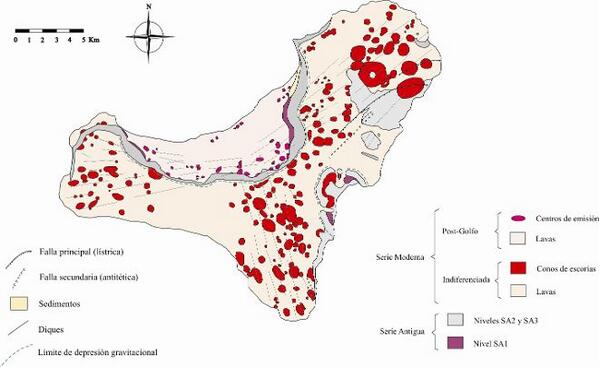
En een zwik plaatjes van de nasleep:


[ Bericht 7% gewijzigd door bwt op 28-12-2013 10:15:32 ]
<a href="http://goo.gl/q8fhTe" target="_blank">FAQ?</a>
<a href="http://goo.gl/gYvZFq" target="_blank">Geel is een zonnige en vrolijke kleur, als hij tenminste enigszins warm is gekleurd en wat naar het oranje neigt</a>
<a href="http://goo.gl/gYvZFq" target="_blank">Geel is een zonnige en vrolijke kleur, als hij tenminste enigszins warm is gekleurd en wat naar het oranje neigt</a>
Maar die HI10 bestaat al langer hoor.quote:2013-12-28 08:58 UTC
No more spectacular earthquakes during the nightly hours.
The New deformation data is showing a somewhat identical picture than yesterday. Stabilizing (or slightly increasing) horizontal and vertical deformations in the El Golfo area and mid-Island stations BUT continued lifting and/or horizontal movement of the El Pinar and La Restinga GPS stations. Lets hope IGN or PEVOLCA will give their views on this in a report later today.
New today is the HI10 station (until today, HI10 was not present on the deformation maps). HI10 (El Julan area) shows the same strong increase than El Pinar and La Restinga, even more as the total lifting deformation since the beginning of this crisis is 10 cm!
What does this mean ? It means that there is still a magma source below the south-eastern part of the island, but without generating earthquakes.
Something else we suggest is that, because of the stabilized western GPS stations, IGN was right in stating that the strong earthquake from yesterday afternoon may have no direct relation with the lifting of HI08, HI09 and HI10.
Does the continued south-eastern deformation will lead to more earthquakes in that part of the island – not necessarily as even more lifting in other places did not necessarily led to earthquakes neither. One additional reason to say this is that, though the lifting was strong at El Pinar, La Restinga and El Julan, only the greater El Pinar area lived through a swarm of earthquakes.
The next hours and days will be “tension” days as everybody will be searching for more clues.
Geofon Germany has published the focal mechanism of the M5.1 earthquake and this shows a strike-slip earthquake (see image below)
Op 29 oktober heb ik de volgende post geplaatst met plaatjes
WKN / Vulkaanuitbarsting bij Canarische Eilanden #5
<a href="http://goo.gl/q8fhTe" target="_blank">FAQ?</a>
<a href="http://goo.gl/gYvZFq" target="_blank">Geel is een zonnige en vrolijke kleur, als hij tenminste enigszins warm is gekleurd en wat naar het oranje neigt</a>
<a href="http://goo.gl/gYvZFq" target="_blank">Geel is een zonnige en vrolijke kleur, als hij tenminste enigszins warm is gekleurd en wat naar het oranje neigt</a>
NEE, dat zou La Palma zijn - ergens over 100 duizend jaar of zo. Elk moment dus.quote:
Dit is toch het eiland dat een mega tsunami veroorzaakt als er wat afbreekt ofzo?
<a href="http://goo.gl/q8fhTe" target="_blank">FAQ?</a>
<a href="http://goo.gl/gYvZFq" target="_blank">Geel is een zonnige en vrolijke kleur, als hij tenminste enigszins warm is gekleurd en wat naar het oranje neigt</a>
<a href="http://goo.gl/gYvZFq" target="_blank">Geel is een zonnige en vrolijke kleur, als hij tenminste enigszins warm is gekleurd en wat naar het oranje neigt</a>
quote:2013-12-28 10:26 UTC
No new data to report but we hope that we will be able to have a clear satellite picture a little later. We are curious to have a look at the ocean water of yesterday’s quakes. These were relatively shallow (there was one from 8 km (the depth of the ocean floor in this area is approx. 3 km)). We remind our readers that the coloring of the see with toxic ingredients started in 2011 before the shallow eruption earthquakes occurred. When the NASA MODIS pictures are available, we will bring them to you.
<a href="http://goo.gl/q8fhTe" target="_blank">FAQ?</a>
<a href="http://goo.gl/gYvZFq" target="_blank">Geel is een zonnige en vrolijke kleur, als hij tenminste enigszins warm is gekleurd en wat naar het oranje neigt</a>
<a href="http://goo.gl/gYvZFq" target="_blank">Geel is een zonnige en vrolijke kleur, als hij tenminste enigszins warm is gekleurd en wat naar het oranje neigt</a>
Dicht en ik maak de volgende wel weer klaar.
WKN / Vulkaanuitbarsting bij Canarische Eilanden #6
Zal de OP nog verder bijwerken gedurende de dag
[ Bericht 20% gewijzigd door bwt op 28-12-2013 14:17:53 ]
WKN / Vulkaanuitbarsting bij Canarische Eilanden #6
Zal de OP nog verder bijwerken gedurende de dag
[ Bericht 20% gewijzigd door bwt op 28-12-2013 14:17:53 ]
<a href="http://goo.gl/q8fhTe" target="_blank">FAQ?</a>
<a href="http://goo.gl/gYvZFq" target="_blank">Geel is een zonnige en vrolijke kleur, als hij tenminste enigszins warm is gekleurd en wat naar het oranje neigt</a>
<a href="http://goo.gl/gYvZFq" target="_blank">Geel is een zonnige en vrolijke kleur, als hij tenminste enigszins warm is gekleurd en wat naar het oranje neigt</a>