WKN Weer, Klimaat en Natuurrampen
Lees alles over het onstuimige weer op onze planeet, volg orkanen en tornado's, zie hoe vulkanen uitbarsten en hoe Moeder Aarde beeft bij een aardbeving. Alles over de verwoestende kracht van onze planeet en tal van andere natuurverschijnselen.


De vorige deeltjes
• [vulkanen] The ring of Fire
• [Vulkanen] The ring of Fire #2:
• [Vulkanen] The ring of Fire #3: Eruption of Mayon?
• [Vulkanen] The ring of fire #4: Veel aktiviteit!
• [Vulkanen] The ring of fire #5: Het blijft actief
In dit en komende topics, zal informatie gegeven worden over vulkanen door enthousiaste Fokkers!, en iedereen die wat weet over vulkanisme, mag hier z'n bijdrage erbij toevoegen.
Hoofdzakelijk zijn het de aardse vulkanen in belangstelling staan. Maar als er op een andere planeet/maan vulkanische aktieviteiten Zijn, dan mag het hier ook terzake komen.
Mocht er een zeer heftige/gewelddadige uitbarsting van een vulkaan plaatsvinden komt er naast dit topic ook nog een eigen topic.
De Aarde
Er zijn bergen, eilanden, en zeeën. En alles op een laag (aardkorst) van ongeveer 35 kilometer dikte.
De aardkorst
Al miljoenen jaren is de aardkost in beweging Door zijn aardbevingen, en er zijn vulkanen laat de aarde merken dat ie nog altijd actief is. De aardkorst bestaat niet uit één groot stuk maar uit een stuk of 9 grote en nog een aantal kleinere tektonische platen. Deze platen drijven op een vloeibare mantel.
En omdat die platen niet allemaal dezelfde kant opgaan. Komt het er op de plaatsen waar ze zich ontmoeten toe tot hevige botsingen. Op deze plekken kunnen zich ook de meeste vulkanen vormen.
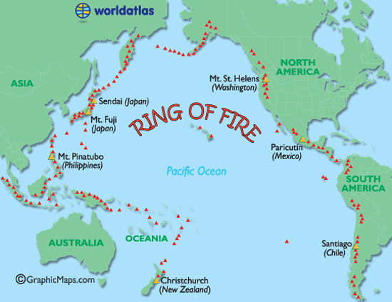
De bekendste term wat betreft vulkanen is toch wel de Ring of Fire. Deze 'circel' omvat zon beetje de hele StilleOceaan waar één grote aardplaat tegen diverse andere botst en rondom die plaat bevinden zich de meeste actieve, maar ook gevaarlijkste, vulkanen.
Ring of Fire
De Mantel
De aardmantel of kortweg mantel is de laag in de opbouw van de Aarde die direct onder de korst ligt. De mantel begint op enkele tientallen kilometers diepte, en is ongeveer 2900 km dik. Ze neemt 83% van het volume van de Aarde in en bevat 67,5 % van haar massa.
Soorten vulkanen
Er zijn 6 verschillende soorten vulkanen.
• De spleetvulkaan
Een lange scheur in de aardkorst waardoor magma naar buiten komt. Deze ontstaat als twee tektonische platen uit elkaar drijven. Je vindt deze vooral bij oceaanruggen.
• De schildvulkaan
Dit is een brede, ondiepe vulkaankegel, die ontstaat doordat het lava dat eruit stroomt, dun en heet is en heel langzaam afkoelt.
• De koepelvulkaan
Deze kent een steile, bolle helling die gevormd is door dikke snel afkoelende lava.
• De slakkenkegel
Een vulkaan die naast lava ook veel as uitspuugt. De berg die door deze vulkaan gevormd wordt, is dan ook opgebouwd uit lagen as en lava die elkaar afwisselen.
• De samengestelde vulkaan
Deze is net zo opgebouwd als de slakkenkegel maar heeft naast de hoofdkrater nog meerdere kleinere kraters op haar flanken.
• De calderavulkaan
Dit is een oudere vulkaan met aan de bovenkant een grote brede krater. In deze krater hebben zich weer kleinere nieuwe kraters gevormd.
• Hotspots
Doordat een zeer hete brandhaard (hot-spot) in de mantel, door de aardkorst heen brandt.
Andere vormen van vulkanisme zijn de geisers en de hete bronnen. Die vind je vaak in de buurt van vulkanen waar de aardkorst dunner is en de warmte van het magma verder doordringt in de aardkorst. Een geiser is een holte in de aardkorst of een waterhoudende grondlaag, die door het onderliggende magma wordt verwarmd tot het kookpunt. Het water kan dan tot 500 meter in de lucht spuiten. Een hete bron werkt op dezelfde manier alleen wordt het water daar niet zo verhit, dat het onder druk van stoom eruit spuit.
Heeft Nederland een vulkaan?
Jazeker! De naam ervan is Zuidwalvulkaan, en ligt 17km ten westen van Harlingen
maar ... die is letterlijk allang dood en begraven. Deze ligt namelijk vele honderden meters onder de bodem van de huidige Waddenzee.
Links
• Status vulkanen Indonesie *NEW*
• Volcano webcams all over the world
• BBC-How volcanoes work
• (Nieuws-)Updates van Vulkaanjager Jon Seach
• Global Volcanism Program
• Volcano Discovery
• Live Science - Volcanoes
• 37 Volcano Cams
• Vulkanen.nl
• Mediatheek - Vulkanen
• vulkaan.startpagina.nl
• Kennislink (Zuidwal vulkaan)
• Vulkanen in de Eifel (Duitsland)
• Planet-wissen [vulkanen](Duitstalig)
Foto's
• Meest spectaculaire vulkaanuitbarstingen op foto
Verwante (aktuele) WKN-vulkaantopics
• Uitbarsting El Hierro Canarische Eilanden
• Vulkaanuitbarsting Chili
• Tungaruhua Ecuador
• Vulkanen IJsland #18
• De Riftvallei, Nieuwe oceaan kan Afrika in tweeën splitsen
Archief en Verzamel topics
• Krakatoa
• Etna
• Supervulkaan Yellowstone #2
• Supervulkaan Yellowstone #1
• Uitbarsting Merapi 2010
• Supervulkaan bij Napels
• Mount St.Helens
Deze OP in Fok!Wiki
• Klik hier
[ Bericht 1% gewijzigd door Frutsel op 07-12-2011 13:53:26 ]
• [vulkanen] The ring of Fire
• [Vulkanen] The ring of Fire #2:
• [Vulkanen] The ring of Fire #3: Eruption of Mayon?
• [Vulkanen] The ring of fire #4: Veel aktiviteit!
• [Vulkanen] The ring of fire #5: Het blijft actief
In dit en komende topics, zal informatie gegeven worden over vulkanen door enthousiaste Fokkers!, en iedereen die wat weet over vulkanisme, mag hier z'n bijdrage erbij toevoegen.
Hoofdzakelijk zijn het de aardse vulkanen in belangstelling staan. Maar als er op een andere planeet/maan vulkanische aktieviteiten Zijn, dan mag het hier ook terzake komen.
Mocht er een zeer heftige/gewelddadige uitbarsting van een vulkaan plaatsvinden komt er naast dit topic ook nog een eigen topic.
De Aarde
Er zijn bergen, eilanden, en zeeën. En alles op een laag (aardkorst) van ongeveer 35 kilometer dikte.
De aardkorst
Al miljoenen jaren is de aardkost in beweging Door zijn aardbevingen, en er zijn vulkanen laat de aarde merken dat ie nog altijd actief is. De aardkorst bestaat niet uit één groot stuk maar uit een stuk of 9 grote en nog een aantal kleinere tektonische platen. Deze platen drijven op een vloeibare mantel.
En omdat die platen niet allemaal dezelfde kant opgaan. Komt het er op de plaatsen waar ze zich ontmoeten toe tot hevige botsingen. Op deze plekken kunnen zich ook de meeste vulkanen vormen.
De bekendste term wat betreft vulkanen is toch wel de Ring of Fire. Deze 'circel' omvat zon beetje de hele StilleOceaan waar één grote aardplaat tegen diverse andere botst en rondom die plaat bevinden zich de meeste actieve, maar ook gevaarlijkste, vulkanen.
Ring of Fire
De Mantel
De aardmantel of kortweg mantel is de laag in de opbouw van de Aarde die direct onder de korst ligt. De mantel begint op enkele tientallen kilometers diepte, en is ongeveer 2900 km dik. Ze neemt 83% van het volume van de Aarde in en bevat 67,5 % van haar massa.


Soorten vulkanen
Er zijn 6 verschillende soorten vulkanen.
• De spleetvulkaan
Een lange scheur in de aardkorst waardoor magma naar buiten komt. Deze ontstaat als twee tektonische platen uit elkaar drijven. Je vindt deze vooral bij oceaanruggen.
• De schildvulkaan
Dit is een brede, ondiepe vulkaankegel, die ontstaat doordat het lava dat eruit stroomt, dun en heet is en heel langzaam afkoelt.
• De koepelvulkaan
Deze kent een steile, bolle helling die gevormd is door dikke snel afkoelende lava.
• De slakkenkegel
Een vulkaan die naast lava ook veel as uitspuugt. De berg die door deze vulkaan gevormd wordt, is dan ook opgebouwd uit lagen as en lava die elkaar afwisselen.
• De samengestelde vulkaan
Deze is net zo opgebouwd als de slakkenkegel maar heeft naast de hoofdkrater nog meerdere kleinere kraters op haar flanken.
• De calderavulkaan
Dit is een oudere vulkaan met aan de bovenkant een grote brede krater. In deze krater hebben zich weer kleinere nieuwe kraters gevormd.
• Hotspots
Doordat een zeer hete brandhaard (hot-spot) in de mantel, door de aardkorst heen brandt.
Andere vormen van vulkanisme zijn de geisers en de hete bronnen. Die vind je vaak in de buurt van vulkanen waar de aardkorst dunner is en de warmte van het magma verder doordringt in de aardkorst. Een geiser is een holte in de aardkorst of een waterhoudende grondlaag, die door het onderliggende magma wordt verwarmd tot het kookpunt. Het water kan dan tot 500 meter in de lucht spuiten. Een hete bron werkt op dezelfde manier alleen wordt het water daar niet zo verhit, dat het onder druk van stoom eruit spuit.
Heeft Nederland een vulkaan?
Jazeker! De naam ervan is Zuidwalvulkaan, en ligt 17km ten westen van Harlingen
maar ... die is letterlijk allang dood en begraven. Deze ligt namelijk vele honderden meters onder de bodem van de huidige Waddenzee.
Links
• Status vulkanen Indonesie *NEW*
• Volcano webcams all over the world
• BBC-How volcanoes work
• (Nieuws-)Updates van Vulkaanjager Jon Seach
• Global Volcanism Program
• Volcano Discovery
• Live Science - Volcanoes
• 37 Volcano Cams
• Vulkanen.nl
• Mediatheek - Vulkanen
• vulkaan.startpagina.nl
• Kennislink (Zuidwal vulkaan)
• Vulkanen in de Eifel (Duitsland)
• Planet-wissen [vulkanen](Duitstalig)
Foto's
• Meest spectaculaire vulkaanuitbarstingen op foto
Verwante (aktuele) WKN-vulkaantopics
• Uitbarsting El Hierro Canarische Eilanden
• Vulkaanuitbarsting Chili
• Tungaruhua Ecuador
• Vulkanen IJsland #18
• De Riftvallei, Nieuwe oceaan kan Afrika in tweeën splitsen
Archief en Verzamel topics
• Krakatoa
• Etna
• Supervulkaan Yellowstone #2
• Supervulkaan Yellowstone #1
• Uitbarsting Merapi 2010
• Supervulkaan bij Napels
• Mount St.Helens
Deze OP in Fok!Wiki
• Klik hier
[ Bericht 1% gewijzigd door Frutsel op 07-12-2011 13:53:26 ]
Laatste nieuws uit vorige deel
WIN EEN DVD-BOX
Win een DVD-box over De Grootste Natuurrampen
LOKON - Indonesie
Uitbarsting vulkaan Puyehue (Chili)
KATLA / HEKLA - IJSLAND
Vulkanen IJsland #17 met een Grimmige Grimsvotn
SOPUTAN - INDONESIE
Vulkaan Soputan barst uit.
RIFTVALLEI - AFRIKA
De Riftvallei, Nieuwe oceaan kan Afrika in tweeën splitsen
TAAL - FILIPIJNEN
Filipijnse 'Taal' vulkaan staat op uitbarsten
WIN EEN DVD-BOX
Win een DVD-box over De Grootste Natuurrampen
LOKON - Indonesie
PUYEHUE - CHILIquote:Meer dan 2000 geëvacueerd rondom Lokon
JAKARTA - Meer dan 2.000 mensen zijn ge-evacueerd nadat de Lokon vulkaan in het noordelijke puntje van Sulawesi tot uitbarsting is gekomen. Dit meldden functionarissen woensdag.
Het hoofd van het Agentschap Beheersing Rampen BPBD, Hoyke Makarawung, liet aan Antara weten dat er inmiddels 2.116 mensen van de hellingen van de vulkaan waren geevacueerd. Alle evacuees zijn naar dorpen in de directe omgeving gebracht, nog in het district Noord Tomohon.
Er zijn vier noodverblijven ingericht in drie christelijke scholen in Tomohon. De coordinerend minister van Welzijn, Agung Laksono, liet weten dat de evacuees in goede toestand waren. De Lokon vulkaan barstte maandag uit, waardoor er onder meer een veiligheidszone van 10 nautische mijlen (zo'n 18,5 kilometer) werd ingesteld rond de vulkaan.
Eerder op maandag werd de alarm-status van de vulkaan plotseling verhoogd naar de hoogste status omdat de 1.500 meter hoge Lokon vulkaan bekend staat om zijn plotseling toenemende en afnemende activiteit. De vulkaan begon om 15:50 uit te barsten, waarbij een dikke bruinige aswolk tot zeker 15 kilometer hoog de lucht in werd gestuurd.
Uitbarsting vulkaan Puyehue (Chili)
KATLA / HEKLA - IJSLAND
Vulkanen IJsland #17 met een Grimmige Grimsvotn
SOPUTAN - INDONESIE
Vulkaan Soputan barst uit.
RIFTVALLEI - AFRIKA
De Riftvallei, Nieuwe oceaan kan Afrika in tweeën splitsen
TAAL - FILIPIJNEN
Filipijnse 'Taal' vulkaan staat op uitbarsten
quote:Vanuatu evacuation alert as volcano rumbles
Vanuatu's Ambae volcano has begun spewing volcanic gases, and residents could be forced to evacuate part of the island.
An expert from the Vanuatu Geohazards Observatory has been sent to monitor the volcano, which has been known to trigger earthquakes.
They have measured an increase in tremor activity in the area and are expecting more explosions.
If the volcano does becomes more active, people living around it will be forced to evacuate.
Volcanologist Sylvain Todman, from the Vanuatu Geohazards Observatory, told Pacific Beat they were watching the situation very closely.
"At the moment we have sporadic explosions but the explosions are getting bigger and bigger every time," he said.

Bron:quote:Keten van vulkanen ontdekt op oceaanbodem
AMSTERDAM - Britse wetenschappers hebben twaalf reusachtige onderwatervulkanen in kaart gebracht in de Atlantische oceaan.
De keten van vulkanen op de zeebodem is op sommige plaatsen bijna 3 kilometer hoog en ligt in de buurt van de Zuidelijke Sandwicheilanden.
In het gebied zijn kraters aangetroffen met een doorsnee van drie tot vier kilometer. Dat meldt Discovery News op basis van een onderzoek van de British Antarctic Survey.
James Cook
De Britse zeevaarder James Cook schreef in 1775 al over vulkaanuitbarstingen voor de kust van de Sandwicheilanden. “Maar het gebied is nooit onderzocht”, aldus hoofdonderzoeker Phil Leats. “Er blijken gigantische bergen te zijn op de zeebodem.”
De vulkanen zijn in kaart gebracht met sonar scans die zijn gemaakt tijdens een expeditie met een schip.
Het vulkanische landschap is ontstaan onder invloed van tektonische platen die op de zeebodem over elkaar heen schuiven. Daarbij is water onder de aardkorst terechtgekomen, wat weer heeft geleid tot uitbarstingen van gesmolten gesteentes. Sommige van de vulkanen zijn recentelijk nog tot uitbarsting gekomen.
Biologen
De ontdekking van de vulkanen is niet alleen interessant voor geologen. Ook biologen zullen binnenkort waarschijnlijk afreizen naar het gebied, omdat er mogelijk nog onbekende organismen leven.
“We weten dat er vaak erg bijzondere ecosystemen met bijzondere levensvormen ontstaan in dit soort gebieden”, aldus Leats.
http://www.nu.nl/wetensch(...)kt-oceaanbodem-.html
Wat een verwarring met al die Cook eilanden.
Dit gaat dus over de argentijnse neem ik aan.
The volcanoes are a result of the South American continental plate sliding under the South Sandwich plate to the east, carrying water down into the deep interior of the earth. The water escapes upward, ultimately leading to eruptions of molten rock.
"We have GPS data to show that the South Sandwich Islands are moving east very fast indeed with respect to Africa," Dalziel said. "It's a very active system."
http://news.discovery.com(...).html#mkcpgn=rssnws1
Van de fp:
De Indonesische vulkaan Mount Lokon in de centraal gelegen provincie Sulawesi is donderdag uitgebarsten. Dat hebben medewerkers van de Indonesische hulpdiensten gemeld. Inwoners in de omgeving zijn op de vlucht geslagen.
De eerste uitbarsting had plaats om 22.46 uur plaatselijke tijd en deed zo'n vijfhonderd mensen op de vlucht slaan. Vlak na middernacht barstte de vulkaan een tweede keer uit en om 01.10 uur plaatselijke tijd volgde een derde uitbarsting.
Het leger en de politie helpen met de evacuatie van het gebied, aldus de hulpdiensten. Tweeduizend inwoners werden woensdag al uit voorzorg geëvacueerd.
De 1750 meter hoge Mount Lokon is een van de 129 actieve vulkanen in Indonesië.
Sulawesie is natuurlijk een eiland en geen provincie btw. Noorden van sulawesie dus nabij manado. Sommigen kennen pulau bunaken daar wel van het mooie duiken daar.
http://maps.google.nl/map(...)fox-a&gl=nl&t=h&z=12
[ Bericht 5% gewijzigd door thesiren.nl op 14-07-2011 22:49:22 ]
Die Lokon lijkt als 2 druppels water op de Batok (bij de Bromo), behalve dan het formaat.
The Hick from French Lick
The camera always points both ways. In expressing the subject, you also express yourself.
The camera always points both ways. In expressing the subject, you also express yourself.

(Gunung Lokon)
The Hick from French Lick
The camera always points both ways. In expressing the subject, you also express yourself.
The camera always points both ways. In expressing the subject, you also express yourself.
het is een berg en er komt vuur uit?quote:Op vrijdag 15 juli 2011 13:45 schreef elcastel het volgende:
Die Lokon lijkt als 2 druppels water op de Batok (bij de Bromo), behalve dan het formaat.
;-)
Inorbit: zeg dat dan typluie triangeljosti
Beauregard: Een beetje FOK!ker laat het brood door z'n moeder smeren.
Ecosia
ek's 'n flash drive, jy's 'n floppy
Beauregard: Een beetje FOK!ker laat het brood door z'n moeder smeren.
Ecosia
ek's 'n flash drive, jy's 'n floppy
Het is niet te hopen dat deze jongens gaan 'puffen'.. 
http://news.nationalgeogr(...)ca-science-tsunamis/
http://news.nationalgeogr(...)ca-science-tsunamis/
Ah.. dat verklaart ook ditquote:Op maandag 18 juli 2011 16:48 schreef Maron het volgende:
Het is niet te hopen dat deze jongens gaan 'puffen'..
http://news.nationalgeogr(...)ca-science-tsunamis/
quote:Antarctica krijgt tsunami-alarm
Antarctica moet een systeem krijgen dat vroeg genoeg waarschuwt voor een tsunami. Dat hebben de lidstaten van het Antarcticaverdrag beslist op een bijeenkomst in Buenos Aires. Ze willen ook dat het toerisme in de zone meer aan banden worden gelegd.
Dat er ooit een tsunami Antarctica bereikt, is weinig waarschijnlijk. Maar het grootste deel van de basissen op Antarctica bevindt zich aan de kust. Bovendien nemen de wetenschappelijke, logistieke en zelfs toeristische activiteiten er toe.
Argentijns voorstel
Het voorstel komt van Argentinië. Op de huidige prognosekaarten voor tsunami's komt Antarctica niet voor, wellicht omdat de menselijke aanwezigheid er te beperkt is, zeggen de Argentijnen. De landen van het Antarcticaverdrag gaan de instituten die deze prognoses maken, nu vragen hun modellen uit te breiden tot de kusten van Antarctica en een rapport op te stellen over de risico's voor de zone.
Antarctica staat niet bekend als seismisch gebied, zeggen experts, maar de laatste jaren werden wel grote bevingen geregistreerd met het hypocentrum (de plaats onder het epicentrum waar de beving ontstaat) in de zeebodem in het gebied. Een van die bewegingen werd in 2007 geregistreerd aan de Zuidelijke Orkney-eilanden, een andere in maart dit jaar aan de Zuidelijke Sandwicheilanden.
Cruiseschepen
Op de bijeenkomst in Buenos Aires kwamen driehonderd vertegenwoordigers samen van de landen die het vijftig jaar oude Antarcticaverdrag hebben ondertekend. Ze willen ook dat er grotere beperkingen komen op het toerisme in de regio.
Sinds de jaren negentig is het aantal toeristen er sterk gestegen, tot 46.000 toeristen per jaar. Dat is tien keer meer dan twintig jaar geleden. Dat komt vooral doordat veel poolschepen na het uiteenvallen van de Sovjet-Unie werden omgebouwd tot cruiseschepen, zegt José María Acero, ondersecretaris van het Antarcticaverdrag.
Door de financiële crisis is het cruiseverkeer in de regio wel met een kwart gedaald en voor het volgende seizoen verwacht men een gelijkaardige terugval, zegt de Internationale Vereniging voor Reisorganisatoren naar Antarctica.
Temperatuur stijgt
Tijdens de bijeenkomst spraken de landen ook hun bezorgdheid uit over de gevolgen van de klimaatwijziging voor Antarctica. Volgens het VN-klimaatpanel is de gemiddelde temperatuur daar de laatste jaren vier keer sneller gestegen dan in de rest van de planeet.
De volgende bijeenkomst vindt in juni volgend jaar plaats in het Australische Hobart
Interessant om te gaan volgen. Cleveland kan weer gaan puffen en dan zit het internationale vliegverkeer weer met de brokkenquote:Alertlevel raised for Cleveland volcano
Recent satellite images of a remote Alaska volcano along a flight route for major airlines show the mountain may be poised for its first big eruption in 10 years, scientists said on Thursday.
The Alaska Volcano Observatory has issued an eruption advisory for the 5,676 foot-tall Cleveland Volcano, located on the uninhabited island of Chuginadak in the Aleutian chain about 940 miles southwest of Anchorage.
The advisory was based on "thermal anomalies" detected by satellite, the observatory said. Those measurements indicate the volcano could erupt at any moment, spewing ash clouds up to 20,000 feet above sea level with little further warning, the observatory said.
A major eruption could disrupt international air travel because Cleveland Volcano, like others in the Aleutians, lies directly below the commercial airline flight path between North America and Asia, said John Power, scientist-in-charge at the Alaska Volcano Observatory.
The volcano's last major eruption came in 2001, when it blasted ash more than 5 miles into the sky and spilled lava from the summit crater. Cleveland has experienced several smaller eruptions or suspected eruptions since then.
So far, airlines have not changed their flight patterns because of Cleveland's heat emissions, said Steve McNutt, a University of Alaska Fairbanks scientist who works at the observatory.
Scientists are not always certain about what is happening at the remote volcano, observatory officials said. The town of Nikolski, the nearest settlement to Cleveland Volcano, is 45 miles away.
Although Cleveland is among the most active of Alaska's roughly 90 volcanoes, no seismic equipment is set up there because the costs of working in such a remote area are prohibitive, observatory officials said.
Still, Cleveland is the only Alaska volcano blamed for an eruption-caused human death in recorded history. A U.S. soldier who was stationed on Chuginadak Island during World War Two disappeared during an eruption and was presumed killed.
Without sophisticated monitors like those used to keep tabs on volcanoes closer to Anchorage and other populated areas, scientists must rely on a variety of other observations to track Cleveland's eruptions, McNutt said. Those include satellite data, eyewitness reports and video from mariners and pilots in the area.
"Cleveland is a particular bugaboo for us because it is right on the air route" with no seismic equipment, Power said.
Overzicht van de quake-swarmquote:Earthquake swarm beneith Canary Islands volcano
Recently El Hierro volcano of the Canary Islands has been experiencing a seismic swarm beneath it, which as of yesterday reached to over 700 events. Most of these events have been at Magnitudes of around 2 (+/-0.5) and are clustered beneath El Hierro whilst the depths of these earthquakes have been roughly between 9 and 16 km for the mostpart, with the exception of a few shallower and deeper quakes, the shallowest of which has been 4 km. If we look at these earthquakes in two plots here http://www.volcano-blog.com/hierro.html we can see the clustering of these earthquakes is mainly confined to an oval area at 10 km depth. El Hierro is a broadly basaltic volcano which might have been active in 1793 although this is uncertain.
So the big question is, what’s happening here? It is possible that there is magma on the move at depth, perhaps moving into a magma chamber. Does this mean that there will be an eruption? Maybe, maybe not. The majority of magma intrusions do not reach the surface, and as has been seen elsewhere, in the past, activity can cease at anytime. As of yet (to my knowledge) there have been no other signs of moving magma at the surface such as ground deformation or increased gas emission, although GPS antenna have been set up by officials at the Canary Islands. For now it is too early to tell what (if anything) will happen, so keep watching.
Interessant misschien? Het is volgens mij een andere vulkaan dan de 'beroemde' van LaPalma uit dit topic:
Mega tsunami door in zee vallen van eiland La Palma?
quote:Mt Karangetang spews fresh lava and ash
A VOLCANO that has been spewing lava and clouds of searing gas high into the air has let out a new, powerful burst, sending panicked villagers streaming down the sides of the mountain.
A man who fell as he was fleeing was injured, said Ludianto, head of the search and rescue team.
The victim suffered only cuts and bruises.
Mount Karangetang on Siau - part of the Sulawesi island chain - started spitting clouds of gas and lava up to 600 metres on Friday, said volcanologist Surono.
Earlier today, hot ash tumbled down its slopes triggering fresh panic.
Nearly 600 people living along Karangetang's slopes have been evacuated, said Tonny Supit, the district chief.
Indonesia lies on the Pacific "Ring of Fire," an arc of volcanos and fault lines encircling the Pacific Basin.
The 1784-metre mountain is one of about 129 active volcanoes in Indonesia. It's last big eruption was in August, killing four people.

Waarschuwing voor giftige gassen toeristische vulkaan Java
De Indonesische autoriteiten waarschuwen mensen minstens twee kilometer afstand te houden tot de vulkaan Papandayan op het eiland Java.
De twee gele kraters van de Papandayan, die normaal gesproken populaire toeristenattracties zijn, spuwen gevaarlijke gassen uit als waterstofsulfide en koolstofmonoxide, zegt de Indonesische vulkanoloog Surono.
De Indonesische autoriteiten hebben het op een na hoogste waarschuwingsniveau ingesteld voor de vulkaan, die in 2002 voor het laatst uitbarstte.
vK
quote:Soputan status increased after ash eruption
UPDATE 14/08-17:03 UTC : Officials told the press that the alert status of Mt Soputan was also increased 1 level to III. This brings the number of volcanoes into the second highest alert level to 5.
NO volcano has the highest alert level so far.
RENEWED ACTIVITY UPDATE 14/08-16:07 UTC : The Soputan volcano once again started spewing ash clouds in the air as he did on July 3. The farmers in the surrounding villages are very concerned for their crops.
It can be called curious that the Indonesian Authorities have only an Alert level II active for this volcano (on a scale of 1 to 4), although a local Sulawesi spokesman told the press that the alert status will probably be raised today to level III. The 1784 meter high volcano spews ash until a level of 12,000 feet (3,700 meter). The density stays moderately dangerous for air traffic for approx. 55 nm (nautical miles) in a westerly direction (source VAAC).
The Indonesian NDMA reports that the first of 2 powerful eruptions started at 09:27 local time (the ash cloud climbed 1,200 above the summit crater). 7 hours later a second burst of ash followed.
Authorities have ordered a 4 km No-Go radius as the NDMA fears for avalanches and pyroclastic flows. So far there are NO reports of injuries or serious damage.
UPDATE 04/07-10:19 UTC : The people working for the Mount Soputan Geological Survey have confirmed that the volcano showed no further eruption pattern. As the mountain was covered by thick clouds, scientist have not seen any alteration of color compared to normal clouds. Therefore they conclude that the activity has stopped.
Additionally we can report that the (explosive) activity of the volcano (ash clouds) resulted in 16 flights to be postponed or canceled at Manado International Airport yesterday.

quote:Aantal trillingen Papandayan boven normaalGARUT - Het aantal trillingen dat gemeten wordt door gevoelige instrumenten rond de Papandayan vulkaan in het district Garut in de provincie West Java laat een stijging zien. Omdat er gisteren in enkele uren tijd zes maal een trilling werd waargenomen, is besloten de alarm-status van de vulkaan te verhogen naar het derde niveau op een schaal van vier.
"Het aantal trillingen onder de Papandayan vulkaan ligt hoger dan gemiddeld normaal is," aldus Momon, dienstdoende observant op de observatiepost in Cisurupan. Het aantal trillingen wordt op dit moment twee maal daags afgelezen. In Augustus zijn in totaal al 48 trillingen geregistreerd, waar dit over de gehele maand juli nog 50 was.
Sinds de laatste uitbarsting van de Papandayan vulkaan op 11 november 2002 is het voor het eerst dat de alarm-status van de vulkaan op het derde niveau is komen te staan. Volgens Momon is er nog geen significante stijging van het water in het kratermeer gemeten. "De overige metingen laten over het algemeen nog een normaal beeld zien," legde Momon uit.
El Hierro eigen topic
Aardbevingszwerm Gran Canaria houdt aan, wat gebeurt daar?
[ Bericht 96% gewijzigd door Frutsel op 24-08-2011 12:25:12 ]
Aardbevingszwerm Gran Canaria houdt aan, wat gebeurt daar?
[ Bericht 96% gewijzigd door Frutsel op 24-08-2011 12:25:12 ]
Marapi dus, niet Merapiquote:Marapi stoot rookwolk uit
BUKITTINGGI - De Marapi vulkaan in West Sumatra - niet te verwarren met de Merapi vulkaan in Midden Java - heeft gisteren opnieuw een witte rookwolk uitgestoten. Dit gebeurde tussen 9 en 10 uur in de morgen lokale tijd. De alarmstatus van de vulkaan stond al op niveau twee op een schaal van vier en ook is er een klimverbod ingesteld voor de top van de vulkaan.
Een uur voordat de witte rookwolk werd uitgestoten, produceerde de 2.891 meter hoge vulkaan ook al een kleine gitzwarte rookwolk gedurende tien minuten. Door de sterke wind werden beide wolken snel uiteengeblazen. Later op de dag ging de top van de vulkaan schuil achter een dichte mist, waardoor niet meer kon waargenomen of er nog meer rookwolken werden uitgespuwt.
Het Agentschap Beheersing Rampen BGPVMB handhaaft de alarmstatus voor de vulkaan vooralsnog. Er zijn namelijk geen verdere aanwijzigingen dat de vulkaan actiever aan het worden is. Een gebied van drie kilometer rond de top van de vulkaan is tot verboden gebied verklaard. Meetinstrumenten op diverse plekken op de hellingen van de vulkaan doen vooralsnog hun werk prima.
In de directe omgeving van de Marapi vulkaan liggen twee andere actieve vulkanen, de Singgalang en Tandikek. Op 3 augustus stootte de vulkaan een aswolk uit tot een hoogte van 1.000 meter. De laatste uitbarsting van de vulkaan was in 2005. Steden in de buurt van de vulkaan zijn onder meer Agam, Tanahdatar, Pariaman, Padangpariaman en Padangpanjang.
quote:Verhoogde status voor vulkaan op Flores (Indonesie)
FLORES - Het Agentschap voor Meteorologie, Klimatologie en Geofysica (BMKG) heeft bekend gemaakt dat het de starmstatus van de Anak Ranakah vulkaan in het district Manggarai op het eiland Flores in zuidoost Indonesië heeft verhoogd naar twee, op een schaal van vier. De 2.247 meter hoge vulkaan stoot vrijwel doorlopend een kleine witte rookpluim uit, maar er is nu ook een verhoogde activiteit waargenomen in de vulkaan zelf.
De vulkaan, die eigenlijk meer een lava-koepel is, is de meest recent gevormde lava-koepel in de Pocok Leok caldera van de Ranakah vulkaan. Deze lava-koepel werd eind december 1987 gevormd. Op 11 januari 1988 barstte de vulkaan voor het laatst met kracht uit vanuit deze nieuw gevormde lava-koepel. Toen bereikte de aswolk een hoogte van acht kilometer. Ook veroorzaakte de vulkaan hete pyroclastische wolken.
Er is vrij weinig bekend over de vulkaan omdat de eerst bekende uitbarsting die van 1988 is. Sindsdien is de vulkaan ook niet meer uitgebarsten. Wel is te meten dat in de vulkaan zich meer en meer trillingen voordoen. Deze trillingen zijn echter zo klein dat ze niet door mensen gevoeld kunnen worden. Op basis van deze gegevens is wel besloten om de alarmstatus voor de vulkaan te verhogen naar twee, zeker omdat de lava-koepel van de vulkaan erg kwetsbaar is.
De vulkaan wordt actief en intensief in de gaten gehouden. De bevolking in het gebied wordt opgeroepen om altijd alert te zijn op de activiteit van de vulkaan. Ook wordt samen met lokale en regionale rampenteams bekeken of eventuele extra voorzorgsmaatregelen nodig zijn. Bezoekers mogen het gebied in de directe omgeving van de Anak Ranakah niet beklimmen bovendien.
Boom Boom... Tambora...
 (Was daar laatst niet een quake in de krater van 5.0 ofzo?)
Die zouden we niet graag zien ploffen denk ik Maar even volgen denk ik.. ondanks dat de verwachtingen niet groots zijn, maar mogelijk wel potentieel voor doomdenkers 

Voor de nietwetenden: Tambora 1815 - the year without summer
[ Bericht 0% gewijzigd door Frutsel op 30-08-2011 15:54:32 ]
De Tamboraquote:Eruptions reader Martin pointed out an new report from the volcanological survey in Indonesia, the PVBMG, that raises the alert level at one of Indonesia's most famous volcanoes, Tambora. Now, many of you volcano enthusiastics would remember Tambora for 1815, when it produces one of the largest eruptions in the past few thousand years. This eruption through enough material and aerosols into the atmosphere to cause significant global cooling, producing the "Year without a Summer" documented across the globe. What most people don't know is that after the 1815 eruption, Tambora has erupted at least 3 known times, all in the scale of VEI 0-2 (rather than the VEI 7 of 1815).
Why do I mention this? Well, with any news of increased seismicity and steam plumes at a volcano like Tambora, you can be sure the fear/panic-mongers will come out in full force. The PVBMG reports says that since April 2011, the volcano has seen intermittent swarms of earthquakes and now at the end of August, there seems to be an increase in these shallow, volcanic earthquakes along with the presence of tremor. Combine that in observations of steam plumes rising tens of meters over the edge of the caldera rim, then you might have the signs of impending activity - thus the elevation of the alert status from Level I to II. Now, what kind of activity might we expect? Most likely we would expect something small, akin to the VEI 0-2 eruptions in 1819, 1880 and 1967, which were mainly lava flows and domes confined to the caldera floor, and most definitely not another VEI 7 event like the 1815 eruption.
Die zouden we niet graag zien ploffen denk ik
Voor de nietwetenden: Tambora 1815 - the year without summer
[ Bericht 0% gewijzigd door Frutsel op 30-08-2011 15:54:32 ]


quote:MEXICO CITY — The Popocatepetl (po-po-ka-TEH-peh-tel) volcano south of Mexico City is shooting blasts of ash from its crater.
Mexico’s national disaster prevention agency says the volcano has spewed ash more than a half mile (a kilometer) into the sky four times Tuesday. It says there is a possibility ash could fall onto Mexico City overnight.
The agency is urging people to stay at least 7 miles (12 kilometers) from the crater.
The 17,886-foot (5,450-meter) volcano is about 40 miles (65 kilometers) southeast of the capital
Damn, gaat die dan toch rare dingen doen?quote:Tambora alert status raised again
Dompu, West Nusa Tenggara. Provincial authorities raised the alert level of Mount Tambora to the second-highest available as observers noted an increase of volcanic activity in the volatile mountain.
“On August 30, we recorded seven volcanic earthquakes and since Sept. 8 the frequency of the quakes rose substantially, to between 12 and 16 per day,” Husnuddin, head of the West Nusa Tenggara Disaster Mitigation Agency (BPBD), told the Jakarta Globe on Sunday.
The BPBD chief said a team of observers had been immediately deployed to Mount Tambora.
The volcano, which was the site of the world’s deadliest eruption on record, showed no apparent visual signs of any upcoming eruption, but data collected on mechanical instruments gave cause for concern.
“We still hope Mount Tambora’s alert level will not increase further. We hope we can lower the status of the volcano. Let us all pray everything will return to normal,” Husnuddin said.
Abdul Haris from the Mount Tambora observatory station said the heightened alert status meant an eight-kilometer exclusion zone was being imposed.
“We fear there will be toxic gas as a direct result of the increased activity,” he said.
Husnuddin said the BPBD swiftly met with leaders of the three districts surrounding the volcano — Dompu, Bima and Sumbawa.
The agency also held talks with the leadership of Pekat and Tambora, two Dompu subdistricts near Tambora’s crater, to discuss possible evacuation plans if the alert status reaches the highest level. The agency also had identified locations for possible shelters to house people living around the volcano.
There are four villages in the two subdistricts that are about eight kilometers from the crater.
The BPBD requested several organizations be on stand-by, including the National Disaster Mitigation Agency (BNPB), the National Search and Rescue Agency (Basarnas) and the country’s Armed Forces, which have already deployed officials to several response stations in the two subdistricts.
Two main evacuation routes for people in the four villages have also been identified.
Er zou ook nog een andere vulkaan op Flores rommelen, de Lewotobi