WKN Weer, Klimaat en Natuurrampen
Lees alles over het onstuimige weer op onze planeet, volg orkanen en tornado's, zie hoe vulkanen uitbarsten en hoe Moeder Aarde beeft bij een aardbeving. Alles over de verwoestende kracht van onze planeet en tal van andere natuurverschijnselen.


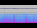
Het valt me nu pas een beetje op....
Lijkt er sterk op dat er al een paar dagen een aardige harmonic tremor (HT) is.
Plaatje van een paar dagen terug:

Lijkt er sterk op dat er al een paar dagen een aardige harmonic tremor (HT) is.
Plaatje van een paar dagen terug:

<a href="http://goo.gl/q8fhTe" target="_blank">FAQ?</a>
<a href="http://goo.gl/gYvZFq" target="_blank">Geel is een zonnige en vrolijke kleur, als hij tenminste enigszins warm is gekleurd en wat naar het oranje neigt</a>
<a href="http://goo.gl/gYvZFq" target="_blank">Geel is een zonnige en vrolijke kleur, als hij tenminste enigszins warm is gekleurd en wat naar het oranje neigt</a>
Daar zit inderdaad wel verschil in. Valt natuurlijk wat minder op nu. Maar er is wat bezig in de (achtergrond)
quote:SPECIAL NOTE AVCAN 038 - 11/07/2012 - 11:15 pm Peninsula. - EVOLUTION AND MONITORING EARTHQUAKE SWARM-VOLCANIC ISLAND OF HIERRO.
The seismicity map updated today, now carry 2 earthquakes located by the IGN in the spectrogram are not located many more .... and yesterday we had 70 that draw more or less the area of the swarm, especially yesterday's gains as yesterday afternoon and seismic activity is concentrated in the coastal area between the lighthouse and Julan Orchilla. GPS data and INVOLCAN IGN indicate that the vertical deformation somewhat low, not so the horizontal, which appears to increase their rate of deformation .. Enrique)
http://www.avcan.org/mapas/AVCAN3749.jpg?d=1341997116
Earthquake of July 11 from 00:00 to 06:00 h UTC - Light Blue (2)
Earthquake of July 10 - Yellow (70)

quote:[bron AVCAN]
Events for absolute share of the tide. This is to check how seismic events occur when the tides reach their ends, ie, high tide or low tide. In this graph, therefore, does not distinguish between high or low tides. The Y, is 100 for both high tide or low and 0 for the "mean tide". For each tidal height, we calculated the extent of their corresponding tide and it calculates the percentage on it without distinguishing whether low or high. It can be seen, the greater concentration of points representing events to the value 100, which means that high tides and low tides in more seismic activity in the "mean tide" and the fact that the most significant events in general and at this stage of the crisis, also occur in high or low tides.

De grafiek laat niet zien dat de bevingen erg mooi met de getijden mee gaan maar op welk moment van de getijden de bevingen zijn.
Het laat dus zien dat de bevingen val alle tijden zijn - ongeacht welk getijde

quote:To complement the above graph, which has generated some questions to be hardly understandable. I think the following is quite explicit and reflects: The number of seismic events and the energy accumulated by absolute share of the tide. Remember, that percentage represents 0 in the "Half Tide" and 100 represents the high tide or low tide. In summary, the graph, accounts of what happens to the mean tide, as opposed to extreme values. For its calculation, computed the actual extent of each trip and we calculated the absolute percentage of tidal height on the amplitude, so that (insist), the value 0 of the abscissa represents the mean tide and the value 100 represents tidal peaks of both the high tide as low tide. Not the subject of this graph, draw conclusions, but to present a statistical study.
[ Bericht 11% gewijzigd door bwt op 11-07-2012 14:17:37 ]
<a href="http://goo.gl/q8fhTe" target="_blank">FAQ?</a>
<a href="http://goo.gl/gYvZFq" target="_blank">Geel is een zonnige en vrolijke kleur, als hij tenminste enigszins warm is gekleurd en wat naar het oranje neigt</a>
<a href="http://goo.gl/gYvZFq" target="_blank">Geel is een zonnige en vrolijke kleur, als hij tenminste enigszins warm is gekleurd en wat naar het oranje neigt</a>
En er is info over de toegenomen HT
quote:Julio says:
July 11, 2012 at 12:33 pm
There have been strong winds at the Island for the past days as you can see in Joke’s Photographs. This results in an increase tremor line in the graphs.
<a href="http://goo.gl/q8fhTe" target="_blank">FAQ?</a>
<a href="http://goo.gl/gYvZFq" target="_blank">Geel is een zonnige en vrolijke kleur, als hij tenminste enigszins warm is gekleurd en wat naar het oranje neigt</a>
<a href="http://goo.gl/gYvZFq" target="_blank">Geel is een zonnige en vrolijke kleur, als hij tenminste enigszins warm is gekleurd en wat naar het oranje neigt</a>
quote:Progression of the average depths of the hypocentres of seismic events per hour, since the beginning of the crisis. Although there are fewer earthquakes per hour, the latest trend appears to be rising with some shallow earthquakes. (JR)

<a href="http://goo.gl/q8fhTe" target="_blank">FAQ?</a>
<a href="http://goo.gl/gYvZFq" target="_blank">Geel is een zonnige en vrolijke kleur, als hij tenminste enigszins warm is gekleurd en wat naar het oranje neigt</a>
<a href="http://goo.gl/gYvZFq" target="_blank">Geel is een zonnige en vrolijke kleur, als hij tenminste enigszins warm is gekleurd en wat naar het oranje neigt</a>

Laatste tijd weer redelijk rustig
Kleine bevinkjes
Kleine bevinkjes
<a href="http://goo.gl/q8fhTe" target="_blank">FAQ?</a>
<a href="http://goo.gl/gYvZFq" target="_blank">Geel is een zonnige en vrolijke kleur, als hij tenminste enigszins warm is gekleurd en wat naar het oranje neigt</a>
<a href="http://goo.gl/gYvZFq" target="_blank">Geel is een zonnige en vrolijke kleur, als hij tenminste enigszins warm is gekleurd en wat naar het oranje neigt</a>
Nog maar een paar bevingen per dag.
Lijkt echt op z'n eind te lopen.
Ondanks dat de vervorming van het eiland nog steeds doorgaat.
Lijkt echt op z'n eind te lopen.
Ondanks dat de vervorming van het eiland nog steeds doorgaat.

SPOILEROm spoilers te kunnen lezen moet je zijn ingelogd. Je moet je daarvoor eerst gratis Registreren. Ook kun je spoilers niet lezen als je een ban hebt.quote:SPECIAL NOTE AVCAN 043 - 07/15/2012 -22:15 h peninsular. - EVOLUTION AND MONITORING EARTHQUAKE SWARM-VOLCANIC ISLAND ON El Hierro.
The seismicity map updated today, now carry 2 earthquakes located by IGN, although in the spectrogram are located but not enough, yesterday we had 10 between the lighthouse area Orchilla south on the Mar de las Calmas. The small rally yesterday morning was further east in the sea area near the coast between the lighthouse and Julan Orchilla. The truth is that the last of yesterday and today have an alignment NW - SE and NS, in addition to other alignments of other days.
The truth is that it should be noted that it was lightning fast with this phenomenon of volcanic reactivation, with a plume of horse, something has put the brake, but far from stopped, be an earthquake of 3.4 shows yesterday or the deformations are rising, especially in the vertical, albeit more slowly.
The truth is that it happens, that seismic activity in the volcanic islands can last for years before finding a way to the surface to form a mouth eruption. In the recent past Canarian volcanism, this has already happened, as was the case of Chinyero or San Juan or the actual eruption of Timanfaya, this specifically, according to the writings of the priest of Yaiza, had in pulses or periods of moderate seismicity strong that when he was stopped by that opened a new mouth, which threw up a time and then stop everything and spend some quiet time until after a month or less started a new seismic pulses that opened up another mouth other and after a while expelling material was returning to stop and so on several times, we shot 6 years is repeating this behavior (Enrique)
Evolution of the depths of earthquakes and energy release in Hierro since July 2011. (JR)
[ Bericht 36% gewijzigd door bwt op 16-07-2012 09:32:00 ]<a href="http://goo.gl/q8fhTe" target="_blank">FAQ?</a>
<a href="http://goo.gl/gYvZFq" target="_blank">Geel is een zonnige en vrolijke kleur, als hij tenminste enigszins warm is gekleurd en wat naar het oranje neigt</a>

quote:Update 16/07 – 07:38 UTC
- There were finally 2 earthquakes at El Hierro yesterday : a M2,1 and a M1.7 at 21 and 22 km depth.
- 2 earthquakes so far today:
03:01:09 Depth 20 km 2.0mbLg SW EL PINAR
05:42:25 Depth 21 km 1.8mbLg SW FRONTERA
- Vertical deformations are down from 1 to 2 cm (one of the biggest deflations so far).
- We expect Pevolca to announce a further normalization of the situation and to change the Yellow alerts on some parts of the island soon to Green again.

<a href="http://goo.gl/q8fhTe" target="_blank">FAQ?</a>
<a href="http://goo.gl/gYvZFq" target="_blank">Geel is een zonnige en vrolijke kleur, als hij tenminste enigszins warm is gekleurd en wat naar het oranje neigt</a>
<a href="http://goo.gl/gYvZFq" target="_blank">Geel is een zonnige en vrolijke kleur, als hij tenminste enigszins warm is gekleurd en wat naar het oranje neigt</a>
1157170 17/07/2012 07:46:10 27.7046 -18.1308 18 3.4 4 SW FRONTERA.IHI (bijgesteld van 3.0 naar 3.4)quote:Update 17/07 – 08:07 UTC
-A new strong earthquake occurred 21 minutes ago. IGN has not listed this earthquake yet. Based on what we see on CHIE we estimate the quake to be in the M3 to M3.5 range.

Dacht dat het wel rustiger zou blijven....

[ Bericht 5% gewijzigd door bwt op 17-07-2012 13:39:08 ]
<a href="http://goo.gl/q8fhTe" target="_blank">FAQ?</a>
<a href="http://goo.gl/gYvZFq" target="_blank">Geel is een zonnige en vrolijke kleur, als hij tenminste enigszins warm is gekleurd en wat naar het oranje neigt</a>
<a href="http://goo.gl/gYvZFq" target="_blank">Geel is een zonnige en vrolijke kleur, als hij tenminste enigszins warm is gekleurd en wat naar het oranje neigt</a>
Die grroene strepen van gister blijken geen bevingen te zijn.
Onbekend wat het dan veroorzaakt heeft.
Verder is het steeds meer afnemende activiteit.
Onbekend wat het dan veroorzaakt heeft.
Verder is het steeds meer afnemende activiteit.
<a href="http://goo.gl/q8fhTe" target="_blank">FAQ?</a>
<a href="http://goo.gl/gYvZFq" target="_blank">Geel is een zonnige en vrolijke kleur, als hij tenminste enigszins warm is gekleurd en wat naar het oranje neigt</a>
<a href="http://goo.gl/gYvZFq" target="_blank">Geel is een zonnige en vrolijke kleur, als hij tenminste enigszins warm is gekleurd en wat naar het oranje neigt</a>
quote:Update 19/07 – 08:30 UTC
- NO earthquakes so far today
- The uplifting from PINA and FRON as reported yesterday and the day before yesterday has reversed into a strong decrease of approx. 0.5 to 1 cm
- The conclusion of the current non-events is that the new swarm episode seems to be completely over
<a href="http://goo.gl/q8fhTe" target="_blank">FAQ?</a>
<a href="http://goo.gl/gYvZFq" target="_blank">Geel is een zonnige en vrolijke kleur, als hij tenminste enigszins warm is gekleurd en wat naar het oranje neigt</a>
<a href="http://goo.gl/gYvZFq" target="_blank">Geel is een zonnige en vrolijke kleur, als hij tenminste enigszins warm is gekleurd en wat naar het oranje neigt</a>
Als er weer iets gebeurd zal er wel weer een update komen.quote:Update 07/08 – 10:21 UTC
An article in Diario El Hierro reports about some findings of the University of La Laguna. The professor indicates that eruption material from El Hierro is among the strongest eruption radioactive material known so far. Click here to read this (Spanish) article.
- Pevolca has changed the alertt level of the south western tip of the island again to green. It was changed into Yellow after the many strong earthquakes. Yellow is maintained at the vent in the Las Calmas sea.
En de zee komt weer tot leven

<a href="http://goo.gl/q8fhTe" target="_blank">FAQ?</a>
<a href="http://goo.gl/gYvZFq" target="_blank">Geel is een zonnige en vrolijke kleur, als hij tenminste enigszins warm is gekleurd en wat naar het oranje neigt</a>
<a href="http://goo.gl/gYvZFq" target="_blank">Geel is een zonnige en vrolijke kleur, als hij tenminste enigszins warm is gekleurd en wat naar het oranje neigt</a>
Volgende valt me wel op: Een aantal bevingen in een gebied waar ze nog niet geweest zijn.
Zal vast wel komen door de stabilisatie op het eiland maar toch......
Zal vast wel komen door de stabilisatie op het eiland maar toch......


<a href="http://goo.gl/q8fhTe" target="_blank">FAQ?</a>
<a href="http://goo.gl/gYvZFq" target="_blank">Geel is een zonnige en vrolijke kleur, als hij tenminste enigszins warm is gekleurd en wat naar het oranje neigt</a>
<a href="http://goo.gl/gYvZFq" target="_blank">Geel is een zonnige en vrolijke kleur, als hij tenminste enigszins warm is gekleurd en wat naar het oranje neigt</a>
Zoals ik de vorige post al vermelde.
En de post van vandaag
[ Bericht 4% gewijzigd door bwt op 14-08-2012 11:05:36 ]
quote:Important Update 13/08 – 16:26 UTC
After a period of relative weak to very weak seismic activity, the magma below El Hierro looks to start another episode as we cannot relate the 6 earthquakes today as stress phenomena. The epicenter of the earthquakes were in between 10 and 14 km, which means that if seismicity today is generated by magma, we have a totally different situation than at the end of June when we constantly has epicenters below 20 km. The location of the epicenters today where also different as the majority was located in the El Golfo Bay and a few others below the island and in the Las Calmas sea.
6 earthquakes so far today is not revolutionary, but at least interesting to give it a close watch
- The seismogram at CHIE does not confirm an increase of the activity, but this can change swiftly as we know from the recent past
- The deformation data from Involcan and the Nogoya University also show an uplifting from a little less than a cm in both PINA and FRON (Ultra Rapid and we trust that the GPS data are still refreshed as it is hard to see on the graph.
- If deformation data and seismicity would continue to increase the following hours and days, we might have a new phase in the El Hierro volcano activity

En de post van vandaag
quote:Update 14/08 07:50 UTC
After the update with 6 earthquakes yesterday, everything went silent again.
Deformation data (vertical) have stabilized again.
[ Bericht 4% gewijzigd door bwt op 14-08-2012 11:05:36 ]
<a href="http://goo.gl/q8fhTe" target="_blank">FAQ?</a>
<a href="http://goo.gl/gYvZFq" target="_blank">Geel is een zonnige en vrolijke kleur, als hij tenminste enigszins warm is gekleurd en wat naar het oranje neigt</a>
<a href="http://goo.gl/gYvZFq" target="_blank">Geel is een zonnige en vrolijke kleur, als hij tenminste enigszins warm is gekleurd en wat naar het oranje neigt</a>
quote:Important Update 15/08 – 08:14 UTC
- We have to add 5 new earthquakes in only 2 hours time. As written yesterday and earlier today, these are certainly no stress related earthquakes. Not powerful at all, but they have a trending which puts some action (magma action ?) at a depth of 10 to 12 km. These quakes are not powerful enough to be dangerous at the short term as well as the depth is still deep enough to not be alarmed, but something is going on down there !
The epicenter locations of these earthquakes are almost all of them in the Sabinosa part of the El Golfo bay
The latest depth of 6 km may be updated later today as this happened often in the past.


quote:Important Update 15/08 14:50 UTC
- Another 5 earthquakes have to be added by the already 6 mentioned earlier on, bringing the total to 11. Depth 11 to 12 km and the depth of the 06:46 quake still stands at 6 km ! Epicenters : close to Sabinosa or in the El Golfo Bay just north of Sabinosa.


Zie ook plaatje met bevings overzicht.

plaatje aangepast naa laatste update
En een nieuw plaatje ter vergelijk van de ochtend van de 16e

[ Bericht 16% gewijzigd door bwt op 16-08-2012 07:40:22 ]
<a href="http://goo.gl/q8fhTe" target="_blank">FAQ?</a>
<a href="http://goo.gl/gYvZFq" target="_blank">Geel is een zonnige en vrolijke kleur, als hij tenminste enigszins warm is gekleurd en wat naar het oranje neigt</a>
<a href="http://goo.gl/gYvZFq" target="_blank">Geel is een zonnige en vrolijke kleur, als hij tenminste enigszins warm is gekleurd en wat naar het oranje neigt</a>
quote:Very important Update 16/08 – 08:19 UTC – A new earthquake swarm has started below El Hierro
- For the 3th day in a row the number of earthquakes are fundamentally increasing below El Hierro. Although not official, we think that speaking of a new earthquake swarm is the only right way of describing the current set of earthquakes.
- No less than 26 earthquakes occurred this morning (from midnight UTC until 07:00 AM)
- The majority of the earthquakes are still weak, but the M2.2 from early this morning was the strongest in a while and the Magnitude pattern tends to become stronger every couple of hours.
- The CHIE seismogram is not showing a lot of action, but the M2.2 can well be seen. CHIE is not the best station at the moment to show the seismic events at his best.
- The depth is continuing around the 10 to 12 km which is a complete difference from the July swarm, but still far away from an eruption. More seismicity at lesser depths is needed to create a pre-eruptive condition. Newt to seismicity, we have also the gas analysis, the deformation, etc who will have to confirm if the present swarm will end in an eruption. The magma pressure should be powerful enough to find his way up.
- We do not know how many University of Nagoya GPS stations are still working, but we know for sure that FRON station still works and shows a vertical increase of many mm, which sounds normal after the present set of increasing earthquakes in the area.
- A reason for concern at this time should be the location of the seismicity (El Golfo Bay and Sabinosa area – including the cliffs south of Sabinosa). Landslides and rockfall may become dangerous at Magnitudes from M4 and up.

avcan plaatje
<a href="http://goo.gl/q8fhTe" target="_blank">FAQ?</a>
<a href="http://goo.gl/gYvZFq" target="_blank">Geel is een zonnige en vrolijke kleur, als hij tenminste enigszins warm is gekleurd en wat naar het oranje neigt</a>
<a href="http://goo.gl/gYvZFq" target="_blank">Geel is een zonnige en vrolijke kleur, als hij tenminste enigszins warm is gekleurd en wat naar het oranje neigt</a>

Inorbit: zeg dat dan typluie triangeljosti
Beauregard: Een beetje FOK!ker laat het brood door z'n moeder smeren.
Ecosia
ek's 'n flash drive, jy's 'n floppy
Beauregard: Een beetje FOK!ker laat het brood door z'n moeder smeren.
Ecosia
ek's 'n flash drive, jy's 'n floppy
Die srepen tussen 7 en 8 uur zijn geen bevingen. Ik gok eerder werkzaamheden aan de apparatuur.
Maar als je kijkt naar de spectogram tussen 5 en 6 uur dan zie je de echte bevingen wel.
clustert lekker samen de laatste 2 dagen.
[ Bericht 9% gewijzigd door bwt op 16-08-2012 18:18:47 ]
Maar als je kijkt naar de spectogram tussen 5 en 6 uur dan zie je de echte bevingen wel.

quote:Update 16/08 13:37 UTC
- 5 more earthquakes in between M0.6 and M1.2 and at depths in between 10 and &é km
Image courtesy Avcan
Update 16/08 11:53 UTC
- We have to continue bringing updates on the seismicity below the island.
4 more earthquakes bringing the total on 32 today. Magnitudes from M1.0 until M1.5. Depths 10-11 km. IGN has updated his list up to 08:30 UTC
- At right a small map with the epicenters of a number of the latest earthquakes.

clustert lekker samen de laatste 2 dagen.

[ Bericht 9% gewijzigd door bwt op 16-08-2012 18:18:47 ]
<a href="http://goo.gl/q8fhTe" target="_blank">FAQ?</a>
<a href="http://goo.gl/gYvZFq" target="_blank">Geel is een zonnige en vrolijke kleur, als hij tenminste enigszins warm is gekleurd en wat naar het oranje neigt</a>
<a href="http://goo.gl/gYvZFq" target="_blank">Geel is een zonnige en vrolijke kleur, als hij tenminste enigszins warm is gekleurd en wat naar het oranje neigt</a>
meer en meer. kleine (erg kleine) bevinkjes
[ Bericht 19% gewijzigd door bwt op 17-08-2012 12:03:58 ]

quote:Update 16/08 – 23:31 UTC
- So far IGN has listed 45 earthquakes today. We see on the seismogram that there are definitely some more quakes later on. They will probably be listed tomorrow morning.
Update 16/08 – 19:42 UTC
- 4 more earthquakes from M0.6 to M1.4 at a depth of 10 to 12 km (15:29 to 16:18 UTC)
Update 16/08 – 16:25 UTC
- 3 more earthquakes from M0.9 to M1.1 at a depth of 11 to 12 km (12:25 to 13:47 UTC)
- Maybe IGN could take a few courses in press reporting at GNS Science New Zealand. If an important new swarm starts, like the one today (even with weak earthquakes), an experienced volcanologist may write 5 sentences in explaining what the opinion of the organization is. Why does a body like Pevolca is to be used for volcanology ? If i would live in Sabinosa, i would love to hear a few words if continuous quakes are occurring below my house.
Update 17/08 07:37 UTC
- A little bit to our surprise, there were no more earthquakes listed yesterday after 18:11. This brings yesterdays total on 45.
- The quakes continued though after midnight and so far today we have noticed 7 volcanic earthquakes (see list below). Epicenters are still in the same perimeter.
- Vertical deformation both at El Pinar and Frontera stations is slightly higher which corresponds with the many, mostly weak earthquakes in the El Golfo area. The SABI station (Sabinosa) of the University of Nagoya does not seem to report data anymore, a pity as almost all the current action takes place in that sector.
[ Bericht 19% gewijzigd door bwt op 17-08-2012 12:03:58 ]
<a href="http://goo.gl/q8fhTe" target="_blank">FAQ?</a>
<a href="http://goo.gl/gYvZFq" target="_blank">Geel is een zonnige en vrolijke kleur, als hij tenminste enigszins warm is gekleurd en wat naar het oranje neigt</a>
<a href="http://goo.gl/gYvZFq" target="_blank">Geel is een zonnige en vrolijke kleur, als hij tenminste enigszins warm is gekleurd en wat naar het oranje neigt</a>
van facebook
quote:On the map updated today, have been 18 today, together with 50 yesterday and 32 of antesdeayer of low magnitude, currently between 2.1 and 0.4, i.e. the intrusion magmatica that is causing this fourth swarm continues its progression between 9 and 12 km in the Gulf today only in the area of the lobe on the left with earthquakes in the alignment NNE - SSW mainlyN-S and NNW-SSE in terms of vibrations, tremors, shock and dizziness, still feeling in many areas of the island, as well as smells... as oil and irritation of eyes and nose in the form of itching in some places and strange behaviour of animals, mainly dogs. All this is convenient to report it to IGN so they have documented what was in addition to the importance that has to monitor the possible opening of an eruptive mouth area... It is very important... http://www.01.ign.es/ign/(...)narioMacrosismico.do summing up this is progressing, and continues intruyendo magma, we have two possibilities, that will begin to move below the island or to begin to pressurize or even to do both things at the moment there is becoming noted... (Henry) http://www.avcan.org/mapas/AVCAN4077.jpg?d=1345235753 earthquakes of August 17 - red dark (18) earthquakes of August 16 - light green (50) earthquakes of August 15 - pink (32) earthquakes of August 14 - dark green (3) earthquakes of August 13 - red (6) earthquakes of August 12-(0) earthquakes of August 11 - light blue (1) earthquakes of August 10 - dark blue (1) earthquakes from 01 August 09 - yellow (22) 14 earthquakes to the 31 June - white (84)
Inorbit: zeg dat dan typluie triangeljosti
Beauregard: Een beetje FOK!ker laat het brood door z'n moeder smeren.
Ecosia
ek's 'n flash drive, jy's 'n floppy
Beauregard: Een beetje FOK!ker laat het brood door z'n moeder smeren.
Ecosia
ek's 'n flash drive, jy's 'n floppy

Ze (IGN) hebben de plaatjes aangepast. De bovenkant er afgesneden en een datum aan de plaatjes gegeven.
En bij het plaatje met 36 uur overzicht zijn de puntjes vergroot.
En heeft het plaatje geen datum.

[ Bericht 8% gewijzigd door bwt op 19-08-2012 12:10:57 ]
<a href="http://goo.gl/q8fhTe" target="_blank">FAQ?</a>
<a href="http://goo.gl/gYvZFq" target="_blank">Geel is een zonnige en vrolijke kleur, als hij tenminste enigszins warm is gekleurd en wat naar het oranje neigt</a>
<a href="http://goo.gl/gYvZFq" target="_blank">Geel is een zonnige en vrolijke kleur, als hij tenminste enigszins warm is gekleurd en wat naar het oranje neigt</a>
Hoe lang zou het nog duren voor hij boven water komt?
In Baden-Badener Badeseen kann man Baden-Badener baden sehen.
Voor wat boven water komt? Ik denk dat er eerst wat magma door de aardkorst moet brekenquote:Op zondag 19 augustus 2012 20:44 schreef Pietverdriet het volgende:
Hoe lang zou het nog duren voor hij boven water komt?
Ik was in de veronderstelling dat de onderzee vulkaan nog steeds actief wasquote:
[..]
Voor wat boven water komt? Ik denk dat er eerst wat magma door de aardkorst moet breken
In Baden-Badener Badeseen kann man Baden-Badener baden sehen.
Nee, De vulkaan is momenteel rustig. Geen magma aan de oppervlakte/onder zee.
Wel is er een verhoogde activiteit diep onder de grond. Zie de hoeveelheid bevingen.
Wel is er een verhoogde activiteit diep onder de grond. Zie de hoeveelheid bevingen.
quote:Update 20/08 – 13:12 UTC
We are currently in the midst of a slightly changing seismicity pattern. Why ? For the past several days we have seen a lot of (mostly weak) earthquakes at a depth from 10 to 13 km, but since yesterday we see more 20 km hypocenters. The deeper quakes are mostly more powerful. The deeper earthquakes are still located at the western tip of the island (June / July swarm)
These are the last 3 earthquakes :

<a href="http://goo.gl/q8fhTe" target="_blank">FAQ?</a>
<a href="http://goo.gl/gYvZFq" target="_blank">Geel is een zonnige en vrolijke kleur, als hij tenminste enigszins warm is gekleurd en wat naar het oranje neigt</a>
<a href="http://goo.gl/gYvZFq" target="_blank">Geel is een zonnige en vrolijke kleur, als hij tenminste enigszins warm is gekleurd en wat naar het oranje neigt</a>


Eigenlijk is het rustig.
Grafiek vanaf juni dit jaar

[ Bericht 10% gewijzigd door bwt op 27-08-2012 11:28:42 ]
<a href="http://goo.gl/q8fhTe" target="_blank">FAQ?</a>
<a href="http://goo.gl/gYvZFq" target="_blank">Geel is een zonnige en vrolijke kleur, als hij tenminste enigszins warm is gekleurd en wat naar het oranje neigt</a>
<a href="http://goo.gl/gYvZFq" target="_blank">Geel is een zonnige en vrolijke kleur, als hij tenminste enigszins warm is gekleurd en wat naar het oranje neigt</a>
En een paar die wat zwaarder zijn geweest (boven de 1.5)
Deze is de 1.5 van 25-8 21:01:30
Deze is de 1.5 van vandaag 28-8 03:07
[ Bericht 20% gewijzigd door bwt op 28-08-2012 09:29:31 ]
Zit ook ff de graphics te bekijken. De gevoeligheid is weer aangepast.quote:
Deze is de 1.5 van 25-8 21:01:30

Deze is de 1.5 van vandaag 28-8 03:07

[ Bericht 20% gewijzigd door bwt op 28-08-2012 09:29:31 ]
<a href="http://goo.gl/q8fhTe" target="_blank">FAQ?</a>
<a href="http://goo.gl/gYvZFq" target="_blank">Geel is een zonnige en vrolijke kleur, als hij tenminste enigszins warm is gekleurd en wat naar het oranje neigt</a>
<a href="http://goo.gl/gYvZFq" target="_blank">Geel is een zonnige en vrolijke kleur, als hij tenminste enigszins warm is gekleurd en wat naar het oranje neigt</a>
En na een 7.9 aardbeving in de filipijnen het volgende:
Zou dit een gevolg zijn van?
filipijnen om 12:47 - hierro om 13:06 - duurt het zo lang voor die schokgolf er is of is het een actie van el Hierro zelf?
Gezien de andere plaatjes gk ik dat het een echo is geweest van de filipijnen.
[ Bericht 12% gewijzigd door bwt op 31-08-2012 16:08:39 ]

Zou dit een gevolg zijn van?
filipijnen om 12:47 - hierro om 13:06 - duurt het zo lang voor die schokgolf er is of is het een actie van el Hierro zelf?
Gezien de andere plaatjes gk ik dat het een echo is geweest van de filipijnen.

[ Bericht 12% gewijzigd door bwt op 31-08-2012 16:08:39 ]
<a href="http://goo.gl/q8fhTe" target="_blank">FAQ?</a>
<a href="http://goo.gl/gYvZFq" target="_blank">Geel is een zonnige en vrolijke kleur, als hij tenminste enigszins warm is gekleurd en wat naar het oranje neigt</a>
<a href="http://goo.gl/gYvZFq" target="_blank">Geel is een zonnige en vrolijke kleur, als hij tenminste enigszins warm is gekleurd en wat naar het oranje neigt</a>
Het is wel weer iets drukker met de bevingen. sinds gister. Zwakke, maar ze zijn er wel.quote:Update 02/09 – 17:33 UTC
- Joke tells us that people living in Sabinosa and in other parts of the El Golfo bay are complaining about strange smells. This goes onfor at least a couple of weeks. ITER and IGN are told to take samples regularly, but the biggest complaint from the population is that nobody tells anything. Those following the events from the beginning do know that this comes not as a surprise to us. Most of the shallow 9-11 km deep quakes are centering in the El Golfo and Sabinosa area.


<a href="http://goo.gl/q8fhTe" target="_blank">FAQ?</a>
<a href="http://goo.gl/gYvZFq" target="_blank">Geel is een zonnige en vrolijke kleur, als hij tenminste enigszins warm is gekleurd en wat naar het oranje neigt</a>
<a href="http://goo.gl/gYvZFq" target="_blank">Geel is een zonnige en vrolijke kleur, als hij tenminste enigszins warm is gekleurd en wat naar het oranje neigt</a>
dat kan heel goed! Die schokgolf heeft tijd nodig om te reizen! er zitten aardig wat km's tussen Filipijnenen en Canarische Eilanden...quote:
En na een 7.9 aardbeving in de filipijnen het volgende:
[ afbeelding ]
Zou dit een gevolg zijn van?
filipijnen om 12:47 - hierro om 13:06 - duurt het zo lang voor die schokgolf er is of is het een actie van el Hierro zelf?
Gezien de andere plaatjes gk ik dat het een echo is geweest van de filipijnen.
[ afbeelding ]
Inorbit: zeg dat dan typluie triangeljosti
Beauregard: Een beetje FOK!ker laat het brood door z'n moeder smeren.
Ecosia
ek's 'n flash drive, jy's 'n floppy
Beauregard: Een beetje FOK!ker laat het brood door z'n moeder smeren.
Ecosia
ek's 'n flash drive, jy's 'n floppy
Het begint al weer goed vandaag!
Dat kan nog wel eens een lange lijst worden.
En hier is ook wat aan de hand geweest tussen 8:00 en 9:00
Dat kan nog wel eens een lange lijst worden.

En hier is ook wat aan de hand geweest tussen 8:00 en 9:00

Als je naar de spec's van dat uur kijkt zie je dat het een technische storing zou kunnen zijn.
Zo rond de 3 minuten is een echte beving.
1164231 07/09/2012 08:03:00 27.7304 -18.0657 11 1.9 4 SW FRONTERA.IHI
De deformatie is ook stabiel.
[ Bericht 23% gewijzigd door bwt op 07-09-2012 15:14:07 ]

Zo rond de 3 minuten is een echte beving.
1164231 07/09/2012 08:03:00 27.7304 -18.0657 11 1.9 4 SW FRONTERA.IHI

De deformatie is ook stabiel.


[ Bericht 23% gewijzigd door bwt op 07-09-2012 15:14:07 ]
<a href="http://goo.gl/q8fhTe" target="_blank">FAQ?</a>
<a href="http://goo.gl/gYvZFq" target="_blank">Geel is een zonnige en vrolijke kleur, als hij tenminste enigszins warm is gekleurd en wat naar het oranje neigt</a>
<a href="http://goo.gl/gYvZFq" target="_blank">Geel is een zonnige en vrolijke kleur, als hij tenminste enigszins warm is gekleurd en wat naar het oranje neigt</a>
En dat zijn dan de bevingen boven de 1.5quote:aantal bevingen
1165027 12/09/2012 03:26:01 27.7183 -18.0725 19 1.9 mbLg SW FRONTERA.IHI [+]
1165014 12/09/2012 02:53:40 27.7716 -18.0928 11 2.0 mbLg W FRONTERA.IHI [+]
1164986 11/09/2012 14:58:39 27.7914 -18.0918 11 1.9 mbLg NW FRONTERA.IHI [+]
1164985 11/09/2012 14:56:54 27.7630 -18.0891 11 1.7 mbLg W FRONTERA.IHI [+]
1164983 11/09/2012 14:50:53 27.7347 -18.0964 20 1.8 mbLg W FRONTERA.IHI [+]
1164978 11/09/2012 14:42:27 27.7694 -18.0891 11 1.8 mbLg W FRONTERA.IHI [+]
1164973 11/09/2012 14:34:18 27.7661 -18.0953 11 1.7 mbLg W FRONTERA.IHI [+]
1164906 11/09/2012 10:16:16 27.7629 -18.0885 11 2.0 mbLg W FRONTERA.IHI [+]
1164782 10/09/2012 23:31:00 27.7863 -18.0837 9 1.6 mbLg NW FRONTERA.IHI [+]
1164781 10/09/2012 23:29:35 27.7740 -18.0908 11 1.7 mbLg W FRONTERA.IHI [+]
1164779 10/09/2012 21:48:19 28.2752 -16.4932 1.6 mbLg NW FASNIA.ITF [+]
1164765 10/09/2012 20:36:31 27.7943 -18.1043 10 1.6 mbLg NW FRONTERA.IHI [+]
1164731 10/09/2012 12:39:54 27.7613 -18.0849 10 2.1 mbLg W FRONTERA.IHI [+]
1164730 10/09/2012 12:13:46 27.7662 -18.0870 10 2.1 mbLg W FRONTERA.IHI [+]
Het is nog steeds rustig vergeleken met eerdere periodes - maar toch.

quote:Update 12/09 07:45 UTC
- 5 earthquakes have been listed by IGN so far today. One earthquake was at a depth of only 6 km, not yet at a potential eruption level, but this is already the 3th shallower earthquake in 2 days.
- Deformations are still up and down with approx. the same values. Yesterday 2 cm deflating, today 2 cm inflating as one can see at the Prof. Sagiya graph below
Update 11/09 23:55 UTC
- And 5 more at the end of the day, which makes a total of 21 earthquakes today

[ Bericht 9% gewijzigd door bwt op 12-09-2012 14:27:12 ]
<a href="http://goo.gl/q8fhTe" target="_blank">FAQ?</a>
<a href="http://goo.gl/gYvZFq" target="_blank">Geel is een zonnige en vrolijke kleur, als hij tenminste enigszins warm is gekleurd en wat naar het oranje neigt</a>
<a href="http://goo.gl/gYvZFq" target="_blank">Geel is een zonnige en vrolijke kleur, als hij tenminste enigszins warm is gekleurd en wat naar het oranje neigt</a>

Oeps
Het is nu in eens een stuk drukker op de grafieken
Het is nu in eens een stuk drukker op de grafieken

De grafiek tussen 10 en 11 uur (lokale tijd)quote:[bron]
1165406 14/09/2012 13:43:37 27.7520 -18.0350 19 2.2 mbLg W FRONTERA.IHI [+]
1165403 14/09/2012 13:03:45 27.7397 -18.0385 18 1.9 mbLg SW FRONTERA.IHI [+]
1165402 14/09/2012 13:01:28 27.7417 -18.0469 18 2.0 mbLg SW FRONTERA.IHI [+]
1165401 14/09/2012 12:43:55 27.7466 -18.0383 17 2.2 mbLg W FRONTERA.IHI [+]
1165400 14/09/2012 12:15:03 27.7557 -18.0347 17 2.1 mbLg W FRONTERA.IHI [+]
1165364 14/09/2012 11:04:51 27.7509 -18.0232 19 2.3 mbLg W FRONTERA.IHI [+]
1165349 14/09/2012 10:36:55 27.7235 -18.0362 18 1.6 mbLg SW FRONTERA.IHI [+]
1165346 14/09/2012 10:32:26 27.7627 -18.0832 10 1.7 mbLg W FRONTERA.IHI [+]
1165347 14/09/2012 10:30:58 27.7429 -18.0346 19 1.6 mbLg SW FRONTERA.IHI [+]
1165344 14/09/2012 10:26:33 27.7654 -18.0815 10 Sentido 2.6 mbLg W FRONTERA.IHI [+]
1165345 14/09/2012 10:10:30 27.7449 -18.0299 20 2.4 mbLg SW FRONTERA.IHI [+]
1165348 14/09/2012 10:10:16 27.7510 -18.0335 20 2.2 mbLg W FRONTERA.IHI [+]
1165335 14/09/2012 09:55:03 27.7879 -18.0844 8 1.5 mbLg NW FRONTERA.IHI [+]
1165330 14/09/2012 09:05:29 27.7709 -18.0838 10 1.9 mbLg W FRONTERA.IHI [+]

<a href="http://goo.gl/q8fhTe" target="_blank">FAQ?</a>
<a href="http://goo.gl/gYvZFq" target="_blank">Geel is een zonnige en vrolijke kleur, als hij tenminste enigszins warm is gekleurd en wat naar het oranje neigt</a>
<a href="http://goo.gl/gYvZFq" target="_blank">Geel is een zonnige en vrolijke kleur, als hij tenminste enigszins warm is gekleurd en wat naar het oranje neigt</a>
Misschien komt het hele eiland wel tot leven! ;-)
Inorbit: zeg dat dan typluie triangeljosti
Beauregard: Een beetje FOK!ker laat het brood door z'n moeder smeren.
Ecosia
ek's 'n flash drive, jy's 'n floppy
Beauregard: Een beetje FOK!ker laat het brood door z'n moeder smeren.
Ecosia
ek's 'n flash drive, jy's 'n floppy
druk dagje 

Inorbit: zeg dat dan typluie triangeljosti
Beauregard: Een beetje FOK!ker laat het brood door z'n moeder smeren.
Ecosia
ek's 'n flash drive, jy's 'n floppy
Beauregard: Een beetje FOK!ker laat het brood door z'n moeder smeren.
Ecosia
ek's 'n flash drive, jy's 'n floppy
En een 3.2 (24KM diep)
1165570 15/09/2012 13:13:24 27.7197 -17.9803 24 Sentido 3.2 4 N EL PINAR.IHI
Het zit wel weer op diepte.
En deze "swarm" zit ook verder naar rechts dan ooit.
De vervorming ziet er nog wel "normaal" uit
[ Bericht 14% gewijzigd door bwt op 15-09-2012 19:21:25 ]
1165570 15/09/2012 13:13:24 27.7197 -17.9803 24 Sentido 3.2 4 N EL PINAR.IHI

Het zit wel weer op diepte.
twitter:teideano twitterde op zaterdag 15-09-2012 om 19:02:22 15772 quakes so far at El Hierro....on our way to the biggest volcanic swarm ever? XD @suw @rschott @usgs http://t.co/QHLuQTYo reageer retweet
 15772 quakes so far at El Hierro....on our way to the biggest volcanic swarm ever? XD @
twitter:teideano twitterde op zaterdag 15-09-2012 om 19:04:38 Oops, sorry, updated pic....15780 and counting.... @suw @rschott @usgs http://t.co/0vTywTmr reageer retweet

En deze "swarm" zit ook verder naar rechts dan ooit.
De vervorming ziet er nog wel "normaal" uit
twitter:teideano twitterde op zaterdag 15-09-2012 om 18:47:33 Deformation evolution at the epicentral site of PINA where new quakes are being located. #volcano #nature #science http://t.co/Nd8wL5Li reageer retweet

[ Bericht 14% gewijzigd door bwt op 15-09-2012 19:21:25 ]
<a href="http://goo.gl/q8fhTe" target="_blank">FAQ?</a>
<a href="http://goo.gl/gYvZFq" target="_blank">Geel is een zonnige en vrolijke kleur, als hij tenminste enigszins warm is gekleurd en wat naar het oranje neigt</a>
<a href="http://goo.gl/gYvZFq" target="_blank">Geel is een zonnige en vrolijke kleur, als hij tenminste enigszins warm is gekleurd en wat naar het oranje neigt</a>
De hernieuwde activiteit gaat er voor zorgen dat we een nieuw deel gaan krijgen.
---------------------------------
Er is ook wweer een sterke vervorming van het eiland waargenomen:
Het ziet er een stukkie rustiger uit vergeleken met gister
---------------------------------
Er is ook wweer een sterke vervorming van het eiland waargenomen:

quote:Update 16/09 – 07:46 UTC
- Until 07:35 today, IGN has listed 73 earthquakes. Magnitudes vary from M1.4 (the weakest they are listing but there are hundreds more below this Magnitude) to M2.7. Maximum magnitude decreased a little bit from yesterday (up to M3.2).
- Focal depth remains the same (no penetration into shallower layers)
- Epicenter location is fairly stable (see image below and compare it to the last images yesterday)
- NO more (listed) earthquakes in the El Golfo bay at the 10 km depth layer.
- In line with what could be expected is that the deformations are up again.
- Frontera GPS station has moved North for about 1.5 cm and was also lifted with about 2 cm.
- El Pinar GPS station showed the same movement.
- Restinga GPS station moved a little eastward, did not move along his latitude axis and was inflated most of these 3 stations.
All these data were Ultra Rapid data coming from Prof. Sagiya, a GPS authority in Japan working at the University of Nagoya.
All the mentioned stations operate automatically, which means that nu human is needed to send the data to the computers of the University. Check PINA, FRON and REST stations here.

Het ziet er een stukkie rustiger uit vergeleken met gister

<a href="http://goo.gl/q8fhTe" target="_blank">FAQ?</a>
<a href="http://goo.gl/gYvZFq" target="_blank">Geel is een zonnige en vrolijke kleur, als hij tenminste enigszins warm is gekleurd en wat naar het oranje neigt</a>
<a href="http://goo.gl/gYvZFq" target="_blank">Geel is een zonnige en vrolijke kleur, als hij tenminste enigszins warm is gekleurd en wat naar het oranje neigt</a>
De huidige bevingen omgezet in geluid....
door AVCAN
door AVCAN
De facebook timeline van AVCAN maar weer eens meer in de gaten gaan houden.quote:Audificación of a fragment of seismic paroxysm occurs in El Hierro during the early hours of September 15, 2012, captured by the IGN MACI station located in Tenerife. 1000 has increased the playback speed. In the second part of the video, slower em presented to about 500, you can see the difference of arrival of P and S waves, a "ta-cuumm", which realizes the distance between the Hierro and Tenerife (Juan Ramon Garcia Martel, AVCAN)
<a href="http://goo.gl/q8fhTe" target="_blank">FAQ?</a>
<a href="http://goo.gl/gYvZFq" target="_blank">Geel is een zonnige en vrolijke kleur, als hij tenminste enigszins warm is gekleurd en wat naar het oranje neigt</a>
<a href="http://goo.gl/gYvZFq" target="_blank">Geel is een zonnige en vrolijke kleur, als hij tenminste enigszins warm is gekleurd en wat naar het oranje neigt</a>
quote:NOTE AVCAN 100 - 14.09.2012 -23:59 h peninsular. - EVOLUTION AND FOLLOW THE EARTHQUAKE SWARM IN-volcanic island of El Hierro. 100 notes from the June 24 earthquake, volcano monitoring eb El Hierro and just today arreón, took more than 40 earthquakes located and unlocated hundreds, come with a fledged revival of the volcanic system that makes you again today
Volcanic Islands, and on multiple sites, not just one, today we see more clearly, two swarms of Hierro volcanic earthquake-mismatched or depth or position ... The first in the Gulf area against Sabinosa about 8 to 11 km depth, and the second in the Gulf but also under the Border area - the Llanillos, deeper about 18-21 km. Watching the hundreds of CHIE earthquakes detected and located just on the seismogram, is the deep system which is generating so much stain and earthquakes in the apparatus, for the times and depths, one thing is clear, there is again a new intrusion of magma at depth as passed on 24 June ... almost anything ... and the worst is that we may have more upside seismicity the next few days .. and of course we'll see deformation and gases that will follow this. updated on the map today, we earthquakes located 43, 12 and 7 before yesterday yesterday, although in the spectrogram and CHIE seismogram are many more, with more a hundred per hour in the last hours giving a spasmodic tremor deep where it is difficult to locate them and have not been located and much besides microseismicity. In the first part of the day are located in shallower swarm area of the Gulf but the second part has been in the deep trend has been reactivated in the last hours to move the seismicity to the S - SE towards Restinga. ... The magnitude of the earthquakes today reaching up to 2.8 for the deep system and 2.6 for the surface. now as when the previous eruption senses besides earthquakes, vibrations are continuous in areas such as Pinar, La Restinga, San Andres, in several urban parts as Tigaday Frontera, Los Llanillos, Las Lajas, Las Toscas, Los Mocanes, and more sites as tips, Sabinosa, Table, The Mocanal, Tamaduste, La Caleta, and even the Parador on the beaches. Some sites also come with noise and bumps and tremors are detectable in the liquid from a bottle in most of the island, as a tremor, surely by the continuous stream of earthquakes that are suffering the island. As odors have not been reported. As for the strange behavior of animals None reported. Curiously enough this morning they received reports Liara all this noise and vibration from other islands, particularly from Palma and Tenerife, which occurs prior to the reactivation in Iron, the less curious. now with so many earthquakes, Luis message reaffirmed very recently of the previous post, inviting everyone to stop by the utility AVCAN web animation (Henry). "There you confirm your intuition: In the box on the right CLICK "Show last 24 hours" and keep the box marked in the upper panel izdo map of "Keeping Score": http://www.avcan.org/
quote:SPECIAL NOTE 100B, monitoring the seismic-volcanic activity of El Hierro, after a rough night, seismically speaking, the system moves, is pressurizing (the earthquake of 3.1 on the advice, which actually may have something stronger if any continuous pressurizing and clear, this indicates that it has not yet found a way out, so it is down there looking for her.
As for the map of earthquakes, apart from making a perfect ball indicating that a swarm produced by new magma intrusion deep seismicity seems to be moving towards the SSE, towards Restinga area, and are accumulations in multiple alignments of earthquakes in the Gulf in directions NNE - SSW more or less inclined NS in the south of the swarm, WNW-ESE, etc.
quote:SPECIAL NOTE 100C, monitoring the seismic-volcanic activity of El Hierro, is very busy, seismically speaking, the system moves, is pressurizing (the 3.2 earthquake a few hours ago on the advice, you may now have one more thing continuous pressurizing strong and clear if this indicates that has not yet found a way out, so it is down there looking for her.
On the map the simicidad, today we have been 108 located, almost all greater than 2.0 and the fact is that in these last hours the seismicity is despalaza SSE towards the Restinga on an axis NNW - SSE from the Gulf as another eruption, but this time points to pass just below the town of La Restinga .. and maybe even El Pinar. (Enrique)
van de AVCAN facebook paginaquote:NOTE 101 AVCAN - 15/09/2012 -23:15 h peninsular. - EVOLUTION AND FOLLOW-VOLCANIC EARTHQUAKE ACTIVITY IN THE ISLAND OF IRON.
We and took over 130 earthquakes located today and many hundreds more unaccounted for that is clearly visible in CHIE as earthquakes chained in some cases become attached as a continuous tremor, better known as spasmodic tremor to be too deep. Of course, for which you have doubts, this is a full-fledged revival of the Iron volcanic system that makes you current again volcanic Canary
Today the first swarm shallow no sign obscured by the noise of the second and the updated map of today, we located 131 earthquakes, 71 yesterday and 12 the day before yesterday, that apart from making a perfect ball about 18-22km, indicating that it is a swarm produced by a powerful new intrusion of magma deep seismicity seems to be moving towards the SSE, looking very well in recent earthquakes blue ... to the area of La Restinga and Pinar, and accumulations are earthquakes in various alignments in the Gulf in directions NNE - SSW more or less inclined NS in the south of the swarm, WNW-ESE, etc. The magnitude of the earthquakes continued pressurizing, today the first 3.1 and then up to 3.2, while for superficial system still at the top of 2.6.l.
Today as when the previous eruption besides tremors caused by earthquakes felt in most of the island and talk of all cliques stray vibrations are ongoing in many areas such as Pinar, La Restinga, Tamaduste, La Caleta, San Andres in several urban parts as Tigaday Frontera, Los Llanillos, Las Lajas, Las Toscas, Los Mocanes, and more sites as tips, Sabinosa, Table, The Mocanal, Tamaduste, La Caleta, and even the Parador on the Beaches . Some sites also come with noise and shock, having been heard several in the Gulf and the tremors are felt in the liquid from a bottle in most of the island, as a tremor, surely by the continuous stream of earthquakes that are suffering the island. As odors have not been reported. As for the strange behavior of animals None reported.
There have also been reports of some earthquakes, as well as noise and vibration from other islands, particularly from Palma, La Gomera and Tenerife.
I remember all that is very important if you feel any of this, you should report it to IGN to have documented what felt besides the importance of monitoring should be opening an area eruptive mouth .. is very important. (Enrique).
<a href="http://goo.gl/q8fhTe" target="_blank">FAQ?</a>
<a href="http://goo.gl/gYvZFq" target="_blank">Geel is een zonnige en vrolijke kleur, als hij tenminste enigszins warm is gekleurd en wat naar het oranje neigt</a>
<a href="http://goo.gl/gYvZFq" target="_blank">Geel is een zonnige en vrolijke kleur, als hij tenminste enigszins warm is gekleurd en wat naar het oranje neigt</a>
Vandaag ziet het er een heel stuk rustiger uit ('s morgens vroeg)
De spike in het blok van 1 uur is een 3.0 die van 5 uur is een 2.8

De spike in het blok van 1 uur is een 3.0 die van 5 uur is een 2.8
<a href="http://goo.gl/q8fhTe" target="_blank">FAQ?</a>
<a href="http://goo.gl/gYvZFq" target="_blank">Geel is een zonnige en vrolijke kleur, als hij tenminste enigszins warm is gekleurd en wat naar het oranje neigt</a>
<a href="http://goo.gl/gYvZFq" target="_blank">Geel is een zonnige en vrolijke kleur, als hij tenminste enigszins warm is gekleurd en wat naar het oranje neigt</a>
ik zie nu het plaatje bij je opmerking over het "rechts" zitten... Het lijkt idd meer onder het eiland zelf te zitten nu ja...
Inorbit: zeg dat dan typluie triangeljosti
Beauregard: Een beetje FOK!ker laat het brood door z'n moeder smeren.
Ecosia
ek's 'n flash drive, jy's 'n floppy
Beauregard: Een beetje FOK!ker laat het brood door z'n moeder smeren.
Ecosia
ek's 'n flash drive, jy's 'n floppy
twitter:teideano twitterde op maandag 17-09-2012 om 12:04:41 #volcano New GPS data from El Hierro. Inflation continues with a high rate. 2.81 cm up in PINA in just 3 days... http://t.co/d67M7KpP reageer retweet

[ Bericht 33% gewijzigd door bwt op 17-09-2012 14:05:35 ]
<a href="http://goo.gl/q8fhTe" target="_blank">FAQ?</a>
<a href="http://goo.gl/gYvZFq" target="_blank">Geel is een zonnige en vrolijke kleur, als hij tenminste enigszins warm is gekleurd en wat naar het oranje neigt</a>
<a href="http://goo.gl/gYvZFq" target="_blank">Geel is een zonnige en vrolijke kleur, als hij tenminste enigszins warm is gekleurd en wat naar het oranje neigt</a>
twitter:teideano twitterde op maandag 17-09-2012 om 13:27:20 #volcano New GPS data from El Hierro. Inflation continues with a high rate. 3.13 cm up in REST in just 3 days... http://t.co/Vu7CeU4H reageer retweet

<a href="http://goo.gl/q8fhTe" target="_blank">FAQ?</a>
<a href="http://goo.gl/gYvZFq" target="_blank">Geel is een zonnige en vrolijke kleur, als hij tenminste enigszins warm is gekleurd en wat naar het oranje neigt</a>
<a href="http://goo.gl/gYvZFq" target="_blank">Geel is een zonnige en vrolijke kleur, als hij tenminste enigszins warm is gekleurd en wat naar het oranje neigt</a>
twitter:teideano twitterde op maandag 17-09-2012 om 13:45:31 #photography Anciente lava flow at El Hierro, Canary Islands, actually suffering a big seismic swarm #volcano http://t.co/XKL1xSte reageer retweet

<a href="http://goo.gl/q8fhTe" target="_blank">FAQ?</a>
<a href="http://goo.gl/gYvZFq" target="_blank">Geel is een zonnige en vrolijke kleur, als hij tenminste enigszins warm is gekleurd en wat naar het oranje neigt</a>
<a href="http://goo.gl/gYvZFq" target="_blank">Geel is een zonnige en vrolijke kleur, als hij tenminste enigszins warm is gekleurd en wat naar het oranje neigt</a>
| Forum Opties | |
|---|---|
| Forumhop: | |
| Hop naar: | |