WKN Weer, Klimaat en Natuurrampen
Lees alles over het onstuimige weer op onze planeet, volg orkanen en tornado's, zie hoe vulkanen uitbarsten en hoe Moeder Aarde beeft bij een aardbeving. Alles over de verwoestende kracht van onze planeet en tal van andere natuurverschijnselen.


Ramptoerist dusquote:Op maandag 18 augustus 2014 21:52 schreef DaMart het volgende:
Het is wel heel verleidelijk om even een ticket te boeken en me daar als een IJslander te gaan gedragen: zodra dat ding uitbarst zo dicht mogelijk bij die vulkaan zien te komen om het natuurgeweld te aanschouwen.
Zal wel mooi worden, heb familie die vrijdag terug van vakantie komt
100.000 katjes
Fuck the EBU!
Fuck the EBU!
quote:We have known for some time that Bárðarbunga was going to do something – we just didn’t know what. Because it is covered in ice, we rely on instruments to reveal its behaviour.
Now it has stirred, it is giving us clues about what it is about to do. The clues from the patterns of earthquakes and earth movements reveal two clusters where magma is moving towards the surface, and if it gets there it will erupt. But whether this will be a gentle or a violent eruption is uncertain at the time of writing.
There is no way to predict when the eruption may happen, but we should get a few hours notice. The good news for air travel is that both clusters are away from the heart of the main volcano which makes it less likely that an eruption will produce the fine ash that causes disruption.
https://theconversation.c(...)bout-to-happen-30642
Volgens onze gids vorig jaar, is dar vrij normaal in IJsland. Zodra er een vulkaan uitbarst, stromen de wegen vol. Niet omdat iedereen wegvlucht, maar juist omdat iedereen naar de vulkaan reist om de uitbarsting te zienquote:
 Op
Op Zou ik overigens ook doen als ik in de buurt woonde
Ik ga al naar het strand als het een beetje waaitquote:Op maandag 18 augustus 2014 22:25 schreef DaMart het volgende:
[..]
Volgens onze gids vorig jaar, is dar vrij normaal in IJsland. Zodra er een vulkaan uitbarst, stromen de wegen vol. Niet omdat iedereen wegvlucht, maar juist omdat iedereen naar de vulkaan reist om de uitbarsting te zien.
Zou ik overigens ook doen als ik in de buurt woonde.
100.000 katjes
Fuck the EBU!
Fuck the EBU!
Hoe vol kan een weg stromen met een heel land dat maar 400k inwoners heeftquote:
[..]
Volgens onze gids vorig jaar, is dar vrij normaal in IJsland. Zodra er een vulkaan uitbarst, stromen de wegen vol. Niet omdat iedereen wegvlucht, maar juist omdat iedereen naar de vulkaan reist om de uitbarsting te zien
Zou ik overigens ook doen als ik in de buurt woonde
Maar ik zou het ook doen als ik er zou wonen
Forcefield City Bewoner

volgens mij nog vrij gevaarlijk ook. Vulkaan ligt onder een gletsjer, die als het gaat smelten voor overstromingen kan zorgen waardoor bruggen e.d. weggeslagen worden. Bekend gegeven in IJsland.quote:
Het is wel heel verleidelijk om even een ticket te boeken en me daar als een IJslander te gaan gedragen: zodra dat ding uitbarst zo dicht mogelijk bij die vulkaan zien te komen om het natuurgeweld te aanschouwen.
lokale bevolking is met vulkanen opgevoed die weten meestal wel hoe en wat wel of niet kan. Net als we hier in het rivierengebied zijn opgegroeid met de gevaren van de rivieren en weten wat wel en niet kan bij hoog waterquote:Op maandag 18 augustus 2014 23:09 schreef aloa het volgende:
[..]
volgens mij nog vrij gevaarlijk ook. Vulkaan ligt onder een gletsjer, die als het gaat smelten voor overstromingen kan zorgen waardoor bruggen e.d. weggeslagen worden. Bekend gegeven in IJsland.
DeLuna vindt me dik ;(
Op zondag 22 juni 2014 12:30 schreef 3rdRock het volgende:
pas als jullie gaan trouwen. nu ben je gewoon die Oom Rubber die met onze mama leuke dingen doet :)
Op zondag 22 juni 2014 12:30 schreef 3rdRock het volgende:
pas als jullie gaan trouwen. nu ben je gewoon die Oom Rubber die met onze mama leuke dingen doet :)
Ik zit van woensdag tot zaterdag in de buurt van Myvatn en reis daarna richting oosten over de ringweg 1. Tussen de F88 en de 864 ligt een brug die over de rivier ligt waar ze dat smeltwater verwachten. Dus hopelijk komt het water niet zo hoog dat de brug het begeeft. Mocht er überhaupt een uitbarsting komen natuurlijk...
Wer lesen kann, ist klar im Vorteil.
Maar je hebt ook toeristen die er op afkomen. Met de vorige vulkaan zijn er doden gevallen door toeristen die de weg kwijt waren geraakt, of zonder benzine kwamen te zitten.quote:
[..]
lokale bevolking is met vulkanen opgevoed die weten meestal wel hoe en wat wel of niet kan. Net als we hier in het rivierengebied zijn opgegroeid met de gevaren van de rivieren en weten wat wel en niet kan bij hoog water
ja dat klopt. Toeristen moeten nooit zomaar erheen gaanquote:
[..]
Maar je hebt ook toeristen die er op afkomen. Met de vorige vulkaan zijn er doden gevallen door toeristen die de weg kwijt waren geraakt, of zonder benzine kwamen te zitten.
DeLuna vindt me dik ;(
Op zondag 22 juni 2014 12:30 schreef 3rdRock het volgende:
pas als jullie gaan trouwen. nu ben je gewoon die Oom Rubber die met onze mama leuke dingen doet :)
Op zondag 22 juni 2014 12:30 schreef 3rdRock het volgende:
pas als jullie gaan trouwen. nu ben je gewoon die Oom Rubber die met onze mama leuke dingen doet :)
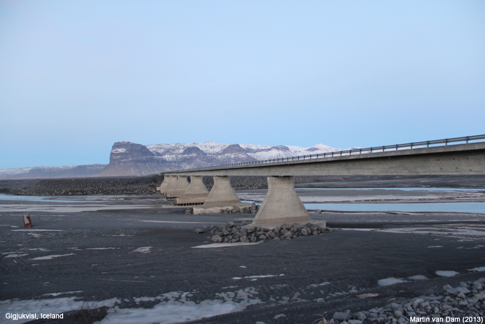
En voor je het weet is dit wat er over is van een brug:quote:
[..]
volgens mij nog vrij gevaarlijk ook. Vulkaan ligt onder een gletsjer, die als het gaat smelten voor overstromingen kan zorgen waardoor bruggen e.d. weggeslagen worden. Bekend gegeven in IJsland.
Als ik me niet vergis, was dit na een uitbarsting van dezelfde vulkaan in 1996.
Hangbrug?quote:
[..]
En voor je het weet is dit wat er over is van een brug:
[ afbeelding ]
Als ik me niet vergis, was dit na een uitbarsting van dezelfde vulkaan in 1996.
100.000 katjes
Fuck the EBU!
Fuck the EBU!
welke brugquote:
[..]
En voor je het weet is dit wat er over is van een brug:
[ afbeelding ]
Als ik me niet vergis, was dit na een uitbarsting van dezelfde vulkaan in 1996.
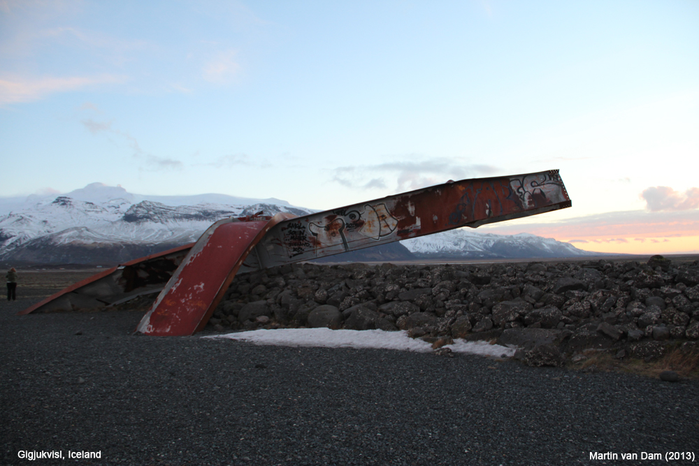
Heb je ook een foto van de verdwenen brug?quote:
[..]
De voorloper van deze brug (dat verwrongen metaal zie je links ervan):
[ afbeelding ]
100.000 katjes
Fuck the EBU!
Fuck the EBU!

Jaquote:
[..]
Heb je ook een foto van de verdwenen brug?
 Op
Op
quote:
[..]
Ik heb alle foto's gemaakt die ik vanavond hier heb geplaatst.
100.000 katjes
Fuck the EBU!
Fuck the EBU!
Zie nu pas dat al die foto's in hetzelfde jaar genomen zijn, ik dacht dat je daar meerdere malen geweest wasquote:
100.000 katjes
Fuck the EBU!
Fuck the EBU!

Nee, Kerst vorig jaar ben ik er een week geweestquote:
[..]
Zie nu pas dat al die foto's in hetzelfde jaar genomen zijn, ik dacht dat je daar meerdere malen geweest was
twitter:gislio twitterde op dinsdag 19-08-2014 om 12:27:47 1/ Getting worried about disrupted flights due to #Bardarbunga ? #ashtag Here are a few tries to calm you:a) Eruption might not happen reageer retweet
 1/ Getting worried about disrupted flights due to
 twitter:gislio twitterde op dinsdag 19-08-2014 om 12:28:48 2/ Stay calm about #Bardarbung (cont’d)b) It may erupt outside of the glacier - causing less ashc) The wind may blow all the ash north reageer retweet
twitter:gislio twitterde op dinsdag 19-08-2014 om 12:29:51 3/ Stay calm about #Bardarbung (cont’d)d) Planes are now allowed to fly in limited ashe) Scientists now have better models where ash is reageer retweet
twitter:gislio twitterde op dinsdag 19-08-2014 om 12:30:49 4/ Stay calm about #Bardarbunga (cont’d)f) It may be 10 years until it actually eruptsg) Media likes to paint worst case scenarios reageer retweet
twitter:gislio twitterde op dinsdag 19-08-2014 om 12:36:07 Still no change in activity in #Bardarbunga - tremors continue & no signs of eruption - @almannavarnir still at uncertainty phase #ashtag reageer retweet
<a href="http://goo.gl/q8fhTe" target="_blank">FAQ?</a>
<a href="http://goo.gl/gYvZFq" target="_blank">Geel is een zonnige en vrolijke kleur, als hij tenminste enigszins warm is gekleurd en wat naar het oranje neigt</a>
<a href="http://goo.gl/gYvZFq" target="_blank">Geel is een zonnige en vrolijke kleur, als hij tenminste enigszins warm is gekleurd en wat naar het oranje neigt</a>
Maar is even in de gaten houden, ga over 3 weken erheen, dus hopelijk is het dan wat rustiger:p
PSN: Metal_Akilla
De verschillen in oost/noord/omhoog
Als ik moet gaan gokken aan de hand van dit plaatje dan is een explosive eruptie niet van toepassing.
Als er al iets gaat gebeuren.
[ Bericht 23% gewijzigd door bwt op 19-08-2014 14:24:52 ]

Als ik moet gaan gokken aan de hand van dit plaatje dan is een explosive eruptie niet van toepassing.
Als er al iets gaat gebeuren.
[ Bericht 23% gewijzigd door bwt op 19-08-2014 14:24:52 ]
<a href="http://goo.gl/q8fhTe" target="_blank">FAQ?</a>
<a href="http://goo.gl/gYvZFq" target="_blank">Geel is een zonnige en vrolijke kleur, als hij tenminste enigszins warm is gekleurd en wat naar het oranje neigt</a>
<a href="http://goo.gl/gYvZFq" target="_blank">Geel is een zonnige en vrolijke kleur, als hij tenminste enigszins warm is gekleurd en wat naar het oranje neigt</a>
twitter:LorcanRK twitterde op dinsdag 19-08-2014 om 14:33:30 @cadarado425 @eruptionsblog and Grimsfjall has moved 6cm south http://t.co/8nR4Z6urOL something pushing them apart in a hurry.. reageer retweet
 @cadarado425 @
<a href="http://goo.gl/q8fhTe" target="_blank">FAQ?</a>
<a href="http://goo.gl/gYvZFq" target="_blank">Geel is een zonnige en vrolijke kleur, als hij tenminste enigszins warm is gekleurd en wat naar het oranje neigt</a>
<a href="http://goo.gl/gYvZFq" target="_blank">Geel is een zonnige en vrolijke kleur, als hij tenminste enigszins warm is gekleurd en wat naar het oranje neigt</a>

ik wil de pret niet bederven maar:
twitter:EIlyinskaya twitterde op dinsdag 19-08-2014 om 13:24:28 @subglacial @gislio 80% of historical eruptions (22 confirmed) were <0.1 km3 and didn't deposit ash beyond Vatnajökull (G.Larsen data) reageer retweet
 @subglacial @
DeLuna vindt me dik ;(
Op zondag 22 juni 2014 12:30 schreef 3rdRock het volgende:
pas als jullie gaan trouwen. nu ben je gewoon die Oom Rubber die met onze mama leuke dingen doet :)
Op zondag 22 juni 2014 12:30 schreef 3rdRock het volgende:
pas als jullie gaan trouwen. nu ben je gewoon die Oom Rubber die met onze mama leuke dingen doet :)
En om nog maar wat meer pret te bederven:
twitter:gislio twitterde op dinsdag 19-08-2014 om 15:14:05 Magma under #Bardarbunga does not seem to be rising, but moving laterally. Unless it finds a way up then this might not end with eruption reageer retweet
DeLuna vindt me dik ;(
Op zondag 22 juni 2014 12:30 schreef 3rdRock het volgende:
pas als jullie gaan trouwen. nu ben je gewoon die Oom Rubber die met onze mama leuke dingen doet :)
Op zondag 22 juni 2014 12:30 schreef 3rdRock het volgende:
pas als jullie gaan trouwen. nu ben je gewoon die Oom Rubber die met onze mama leuke dingen doet :)
ik houd het ook op een media-hype. IJsland heeft zo vaak uitbarstingen, en dat heeft in totaal 1 keer tot een enorme verstoring van het vliegverkeer gezorgt.quote:
En om nog maar wat meer pret te bederven:twitter:gislio twitterde op dinsdag 19-08-2014 om 15:14:05 Magma under #Bardarbunga does not seem to be rising, but moving laterally. Unless it finds a way up then this might not end with eruption reageer retweet
Maar goed, ik ben geen deskundige.
[b]Op maandag 6 september 2010 00:28 schreef tong80 het volgende:[/b]
GVD Wat moet jij een trotse vader zijn :)
:P
GVD Wat moet jij een trotse vader zijn :)
:P
en een mooiere webcam.twitter:eruptionchaser twitterde op dinsdag 19-08-2014 om 15:05:42 @eruptionsblog @subglacial Latest IMO update: http://t.co/403tGD0CT3 reageer retweet
 @eruptionsblog @
twitter:jonfr500 twitterde op dinsdag 19-08-2014 om 16:24:11 @eruptionsblog Bárðarbunga web camera. http://t.co/dBBydHt2Ii reageer retweet
 @eruptionsblog Bárðarbunga web camera.
 [ Bericht 31% gewijzigd door bwt op 19-08-2014 16:41:35 ]
<a href="http://goo.gl/q8fhTe" target="_blank">FAQ?</a>
<a href="http://goo.gl/gYvZFq" target="_blank">Geel is een zonnige en vrolijke kleur, als hij tenminste enigszins warm is gekleurd en wat naar het oranje neigt</a>
<a href="http://goo.gl/gYvZFq" target="_blank">Geel is een zonnige en vrolijke kleur, als hij tenminste enigszins warm is gekleurd en wat naar het oranje neigt</a>
Aan het eind van het filmpje goed te zien dat de grote intensiteit naar het noordoosten weg trekt.quote:
Animatie van aardbevingen rond de vulkaan http://www.ruv.is/frett/s(...)rbungu-a-10-sekundum
Druk lijkt daarmee weg te trekken.
<a href="http://goo.gl/q8fhTe" target="_blank">FAQ?</a>
<a href="http://goo.gl/gYvZFq" target="_blank">Geel is een zonnige en vrolijke kleur, als hij tenminste enigszins warm is gekleurd en wat naar het oranje neigt</a>
<a href="http://goo.gl/gYvZFq" target="_blank">Geel is een zonnige en vrolijke kleur, als hij tenminste enigszins warm is gekleurd en wat naar het oranje neigt</a>
twitter:jonfr500 twitterde op dinsdag 19-08-2014 om 21:13:37 @eruptionsblog Almannavarnir have declared Alert Phase in the area close to Bárðarbunga. reageer retweet
twitter:gislio twitterde op dinsdag 19-08-2014 om 21:18:36 Alert phase declared by @almannavarnir for area north of #Bardarbunga #ashtag http://t.co/OZO1UL7ZBa reageer retweet
quote:The Police Commissioner in Húsavík and Seyðisfjörður have decided to close and evacuate the area North of Vatnajökull following the seismic activity in Bárðarbunga.
This decision is a safety measure. It cannot be ruled out that the seismic activity in Bárðarbunga could lead to a volcanic eruption. There is no change in the seismic activity at the moment and no sign of an eruption and but experience shows that seismic activity can be on going for a long time with out an eruption going off. This is first and foremost a precautionary action since the evacuation of the area is impossible on a short notice.
In accordance with procedure, the National Commissioner of the Icelandic Police has raised the Civil Protection level to Alert Phase. All roads leading into the area are now closed and the authorities in Húsavík and Seyðisfjörður are evacuating the area North of Vatnajökull.
The Civil Protection Alert Phase is declared; if threat assessment shows that hazard is increasing, a preventive measure must be taken immediately to secure the safety of those who are in the area. That is done by strengthening response measures in the area, and by taking preventive actions such as evacuation and closing off the area in question. Increased preparedness and warnings are also common in this phase."
<a href="http://goo.gl/q8fhTe" target="_blank">FAQ?</a>
<a href="http://goo.gl/gYvZFq" target="_blank">Geel is een zonnige en vrolijke kleur, als hij tenminste enigszins warm is gekleurd en wat naar het oranje neigt</a>
<a href="http://goo.gl/gYvZFq" target="_blank">Geel is een zonnige en vrolijke kleur, als hij tenminste enigszins warm is gekleurd en wat naar het oranje neigt</a>
Toeristen zijn gewaarschuwd. Vee wordt verplaatst etc. etc. Dat is wat ik er tot nu toe uit opmaakquote:twitter:jonfr500 twitterde op dinsdag 19-08-2014 om 21:13:37 @eruptionsblog Almannavarnir have declared Alert Phase in the area close to Bárðarbunga. reageer retweetBen er nog niet achter wat er nu aan de hand istwitter:gislio twitterde op dinsdag 19-08-2014 om 21:18:36 Alert phase declared by @almannavarnir for area north of #Bardarbunga #ashtag http://t.co/OZO1UL7ZBa reageer retweet
DeLuna vindt me dik ;(
Op zondag 22 juni 2014 12:30 schreef 3rdRock het volgende:
pas als jullie gaan trouwen. nu ben je gewoon die Oom Rubber die met onze mama leuke dingen doet :)
Op zondag 22 juni 2014 12:30 schreef 3rdRock het volgende:
pas als jullie gaan trouwen. nu ben je gewoon die Oom Rubber die met onze mama leuke dingen doet :)
evacuatie van het gebied dus volgens de link
seismisch niets veranderd dus.
Alleen voor de bevolking zodat de overheid de juiste acties kan gaan uitvoeren omdat evacuatie niet in een paar minuten geregeld is.
seismisch niets veranderd dus.
Alleen voor de bevolking zodat de overheid de juiste acties kan gaan uitvoeren omdat evacuatie niet in een paar minuten geregeld is.
<a href="http://goo.gl/q8fhTe" target="_blank">FAQ?</a>
<a href="http://goo.gl/gYvZFq" target="_blank">Geel is een zonnige en vrolijke kleur, als hij tenminste enigszins warm is gekleurd en wat naar het oranje neigt</a>
<a href="http://goo.gl/gYvZFq" target="_blank">Geel is een zonnige en vrolijke kleur, als hij tenminste enigszins warm is gekleurd en wat naar het oranje neigt</a>
Little has changed since yesterday (18-August-2014) in Bárðarbunga volcano. Earthquake activity has been moving east and north-east since yesterday but continues at same rate as before. It is not clear why that is, but is getting close to Kverkfjöll volcano, but at the moment the earthquake swarm is inside a fissure swarm that belongs to Bárðarbunga volcano. I do not know what happens if magma from Bárðarbunga volcano gets into contact with magma in Kverkfjöll volcano.
http://www.jonfr.com/volcano/?p=4728
http://www.jonfr.com/volcano/?p=4728
Mijn schoonfamilie woont in IJsland in Olafsfjordur, Reykjavik, Mosfellsbær en Kopavogur.
Maar ze zijn er zelf redelijk rustig onder eigenlijk.
Maar ben stiekem wel blij dat ik er nu niet ben.
http://icelandmag.com/art(...)uring-first-48-hours
Maar ze zijn er zelf redelijk rustig onder eigenlijk.
Maar ben stiekem wel blij dat ik er nu niet ben.
http://icelandmag.com/art(...)uring-first-48-hours
"One cries because one is sad. For example, I cry because others are stupid, and that makes me sad."
Informatieve tweets:
[ Bericht 16% gewijzigd door bwt op 20-08-2014 09:12:00 ]
twitter:EricHolthaus twitterde op woensdag 20-08-2014 om 00:01:52 These people know a lot about volcanoes in Iceland: @subglacial @gislio @eruptionsblog @almannavarnir @sigrunda #Barðarbunga #ashtag reageer retweet
 These people know a lot about volcanoes in Iceland: @
-------- Update tweetstwitter:gislio twitterde op dinsdag 19-08-2014 om 23:50:22 Iceland National Radio @RUVfrettir has created a special online news section in English for #Bardarbunga http://t.co/dFgDHCj9IU #ashtag reageer retweet
twitter:gislio twitterde op woensdag 20-08-2014 om 00:36:16 Map showing the area north of #Bardarbunga closed and being evacuated - http://t.co/pRlSxTxpCU via @RUVfrettir #ashtag reageer retweet
twitter:gislio twitterde op woensdag 20-08-2014 om 08:13:15 The earthquakes at #Bardarbunga continued through the night. Still no sign of #eruption. Potential flood area evacuated overnight #ashtag reageer retweet
twitter:gislio twitterde op woensdag 20-08-2014 om 08:17:29 Map showing potential glacial flood routes from #Bardarbunga - http://t.co/eY2xgtczfX (via @mblfrettir) #ashtag reageer retweet
[ Bericht 16% gewijzigd door bwt op 20-08-2014 09:12:00 ]
<a href="http://goo.gl/q8fhTe" target="_blank">FAQ?</a>
<a href="http://goo.gl/gYvZFq" target="_blank">Geel is een zonnige en vrolijke kleur, als hij tenminste enigszins warm is gekleurd en wat naar het oranje neigt</a>
<a href="http://goo.gl/gYvZFq" target="_blank">Geel is een zonnige en vrolijke kleur, als hij tenminste enigszins warm is gekleurd en wat naar het oranje neigt</a>
twitter:gislio twitterde op woensdag 20-08-2014 om 13:56:58 Activity east of #Bardarbunga has increased in the last few hours. Activity in other areas has gone down. #ashtag reageer retweet

DeLuna vindt me dik ;(
Op zondag 22 juni 2014 12:30 schreef 3rdRock het volgende:
pas als jullie gaan trouwen. nu ben je gewoon die Oom Rubber die met onze mama leuke dingen doet :)
Op zondag 22 juni 2014 12:30 schreef 3rdRock het volgende:
pas als jullie gaan trouwen. nu ben je gewoon die Oom Rubber die met onze mama leuke dingen doet :)
14:00 Een aantal boeren in het noordelijk gedeelte van het betreffende hooglandgebied heeft besloten, om vervroegd de vrij rondlopende schapen terug te halen naar de boerderijen. Dit is ook puur een voorzorgsmaatregel, net zoals de evacuatie van toeristen in het gebied.
--------------
11:30 Ondanks dat er veel wordt gesproken over de mogelijke ontwikkelingen, is het algemene beeld dat men niet (exact) weet wat er precies gaat gebeuren.
Dit is voor alle wetenschappers een nieuwe plek met nieuwe verschijnselen. Oude uitbarstingen liggen te ver in het verleden om goede detailinformatie te hebben.
Dus kan men op dit moment niet veel anders doen dan nauwgezet monitoren ......... en afwachten.........
--------------
@IJslandenzo
--------------
11:30 Ondanks dat er veel wordt gesproken over de mogelijke ontwikkelingen, is het algemene beeld dat men niet (exact) weet wat er precies gaat gebeuren.
Dit is voor alle wetenschappers een nieuwe plek met nieuwe verschijnselen. Oude uitbarstingen liggen te ver in het verleden om goede detailinformatie te hebben.
Dus kan men op dit moment niet veel anders doen dan nauwgezet monitoren ......... en afwachten.........
--------------
@IJslandenzo
En een tweet over googlemaps over het gebied van de vulkaantwitter:gislio twitterde op woensdag 20-08-2014 om 14:13:25 Follow @almannavarnir @Landsbjorg @raudikrossinn @Vegagerdin for official updates on preparedness and response to #Bardarbunga #ashtag reageer retweet
En een site waar je semi "realtime" de lokatie van de bevingen kan zien met webcam beeld er bij.twitter:gislio twitterde op woensdag 20-08-2014 om 12:08:53 Beautiful 360 degree images of Dettifoss now available on @Google Street View http://t.co/d6WiWt9tBt - good timing for #Bardarbunga #ashtag reageer retweet
http://baering.github.io/
[ Bericht 18% gewijzigd door bwt op 20-08-2014 16:48:29 ]
<a href="http://goo.gl/q8fhTe" target="_blank">FAQ?</a>
<a href="http://goo.gl/gYvZFq" target="_blank">Geel is een zonnige en vrolijke kleur, als hij tenminste enigszins warm is gekleurd en wat naar het oranje neigt</a>
<a href="http://goo.gl/gYvZFq" target="_blank">Geel is een zonnige en vrolijke kleur, als hij tenminste enigszins warm is gekleurd en wat naar het oranje neigt</a>
Van: http://www.jonfr.com/volcano/?p=4736quote:This earthquake is a long period event. It is created when magma breaks into the crust and creates a pathway for it self. In doing so a gas is released under pressure, this also a creates earthquake and due to how this earthquake is created and due to influence of magma and gas the earthquake has long period signature. This means at some magma is breaking an path to the surface, if that magma is enough to start an eruption is not known at the moment. This magma is under high pressure, since the glacier on top of it is at least 600 meters thick.
17:00 Vanmiddag is een team de gletsjer opgegaan om meer GPS- en seismo-apparatuur te plaatsen rond het Bardarbunga-gebied. Doel is (uiteraard) om nog meer inzicht te krijgen in de huidige verschijnselen, zoals rijzen-dalen van het gletsjeroppervlak en nog betere/nauwkeuriger registratie van de bevingen.
Vooralsnog is er geen wijziging in de huidige situatie. De magma-verplaatsingen vinden plaats op een diepte van 5 Km en dieper, en lijken op dit moment niet naar de oppervlakte te komen.
@IJslandenzo
Vooralsnog is er geen wijziging in de huidige situatie. De magma-verplaatsingen vinden plaats op een diepte van 5 Km en dieper, en lijken op dit moment niet naar de oppervlakte te komen.
@IJslandenzo
With a fidgety volcano on their hands, officials in Iceland have begun preparations for what could be a busy week.
An intense earthquake swarm began Saturday deep beneath Bárðarbunga, Iceland’s largest volcano complex. (Here’s how to pronounce it.) As of Tuesday, the Icelandic Met Office cautions there’s no evidence yet of magma moving toward the surface or that an eruption is imminent. Still, Iceland is springing into action, which suggests the threat is real. These people know their volcanoes.
http://www.slate.com/blog(...)src=sh_all_dt_tw_top
Activiteit, althans in # aardbevingen, was gisteren hoogste tot nogtoe.
16/8 - 204
17/8 - 396
18/8 - 373
19/8 - 405
20/8 - 473
Benieuwd wat het vandaag brengt..
http://www.ijsland-enzo.nl/ijsland/actueel_aardbeving.asp
16/8 - 204
17/8 - 396
18/8 - 373
19/8 - 405
20/8 - 473
Benieuwd wat het vandaag brengt..
http://www.ijsland-enzo.nl/ijsland/actueel_aardbeving.asp
Scilt ende Vrient!
Als je de bevingen onder de 1.0 mee rekent kom je rond de 1000.quote:
Activiteit, althans in # aardbevingen, was gisteren hoogste tot nogtoe.
16/8 - 204
17/8 - 396
18/8 - 373
19/8 - 405
20/8 - 473
Benieuwd wat het vandaag brengt..
http://www.ijsland-enzo.nl/ijsland/actueel_aardbeving.asp
http://www.ruv.is/frett/1000-earthquakes-on-wednesday
quote:Around 1000 earthquakes have been detected in the Bardarbunga region of Vatnajokull glacier since midnight Tuesday evening until midnight tonight. The largest quakes measured around 3 in size and took place at 16:14 and 23:37 near Bardarbunga.

<a href="http://goo.gl/q8fhTe" target="_blank">FAQ?</a>
<a href="http://goo.gl/gYvZFq" target="_blank">Geel is een zonnige en vrolijke kleur, als hij tenminste enigszins warm is gekleurd en wat naar het oranje neigt</a>
<a href="http://goo.gl/gYvZFq" target="_blank">Geel is een zonnige en vrolijke kleur, als hij tenminste enigszins warm is gekleurd en wat naar het oranje neigt</a>


quote:
Het gerommel lijkt nu op te houden:
[ afbeelding ]
Old moderators never die, they just smell that way!
Op dinsdag 5 januari 2010 20:40 schreef nokwanda het volgende:
En natuuuuuurlijk was jij dat weer. Smeerpijp dat je der bent :P _O-
Bullie is thuis X-Rated Epic fail
Op dinsdag 5 januari 2010 20:40 schreef nokwanda het volgende:
En natuuuuuurlijk was jij dat weer. Smeerpijp dat je der bent :P _O-
Bullie is thuis X-Rated Epic fail
of er is nu ergens serieus iets aan het opbouwen dat er straks in 1 knal uitkomtquote:
 Op
Op
[b]Op maandag 6 september 2010 00:28 schreef tong80 het volgende:[/b]
GVD Wat moet jij een trotse vader zijn :)
:P
GVD Wat moet jij een trotse vader zijn :)
:P

Ik heb toch echt een ander beeldquote:
Het gerommel lijkt nu op te houden:
[ afbeelding ]

Hmmm. Dan waren ze vast meetgegevens aan het herzien ofzo.quote:Op donderdag 21 augustus 2014 13:06 schreef lipjes het volgende:
[..]
Ik heb toch echt een ander beeld
[ afbeelding ]
De heftigste uitbarsting van de Bardarbunga had een VEI van 6. Hopelijk evenaart hij dat niet want dat is best wel heftig.
Old moderators never die, they just smell that way!
Op dinsdag 5 januari 2010 20:40 schreef nokwanda het volgende:
En natuuuuuurlijk was jij dat weer. Smeerpijp dat je der bent :P _O-
Bullie is thuis X-Rated Epic fail
Op dinsdag 5 januari 2010 20:40 schreef nokwanda het volgende:
En natuuuuuurlijk was jij dat weer. Smeerpijp dat je der bent :P _O-
Bullie is thuis X-Rated Epic fail
quote:
Het gerommel lijkt nu op te houden:
[ afbeelding ]
Lijkt er inderdaad op dat de data bijgewerkt moest worden.quote:
[..]
Ik heb toch echt een ander beeld
[ afbeelding ]
Het ziet er nog steeds erg druk uit.
http://en.vedur.is/earthq(...)thquakes/vatnajokull
<a href="http://goo.gl/q8fhTe" target="_blank">FAQ?</a>
<a href="http://goo.gl/gYvZFq" target="_blank">Geel is een zonnige en vrolijke kleur, als hij tenminste enigszins warm is gekleurd en wat naar het oranje neigt</a>
<a href="http://goo.gl/gYvZFq" target="_blank">Geel is een zonnige en vrolijke kleur, als hij tenminste enigszins warm is gekleurd en wat naar het oranje neigt</a>
Laki 2.0?twitter:gislio twitterde op donderdag 21-08-2014 om 16:16:39 Scientists say a 25km long "dyke" is forming at a depth of 5-10km under #Bardarbunga - no signs of magma finding a route to the surface reageer retweet
Jonn was gisteren bang voor een krachtige Bárðarbunga vulkaan explosie. De zwaarste bevingen komen daar nu toch vandaan.
Notes from the scientists' meeting
* No signs of diminishing activity around Bárðarbunga
*An intrusion, 25 km long, has formed beneath Dyngjujökull, at a depth of 5-10 km
*The aircraft TF-SIF, from the Icelandic Coast Guard, is now available for scientists
*The aviation colour code is still orange
De bevingen onder de bardarbunga krater nemen af omdat de magma richting noord/oost trekt.
[ Bericht 32% gewijzigd door bwt op 21-08-2014 18:53:27 (Voldoende edit's gedaan) ]
* No signs of diminishing activity around Bárðarbunga
*An intrusion, 25 km long, has formed beneath Dyngjujökull, at a depth of 5-10 km
*The aircraft TF-SIF, from the Icelandic Coast Guard, is now available for scientists
*The aviation colour code is still orange
oftewel:twitter:eruptionsblog twitterde op donderdag 21-08-2014 om 17:52:13 Most interesting bit: subsidence at Bardarbunga, which could mean magma draining from under the edifice to new intrusion to east. reageer retweet
 Most interesting bit: subsidence at Bardarbunga, which could mean magma draining from under the edifice to new intrusion to east.
 De bevingen onder de bardarbunga krater nemen af omdat de magma richting noord/oost trekt.
twitter:eruptionsblog twitterde op donderdag 21-08-2014 om 18:08:30 @jonfr500 @aficientifico Well, IMO thinks its lateral movement of magma out from the caldera to the focus of seismicity. reageer retweet
twitter:subglacial twitterde op donderdag 21-08-2014 om 18:41:26 #Bárðarbunga A calming thought. Volcanoes are complex natural systems, and during periods of unrest scientists get a good handle on what 1/3 reageer retweet

twitter:subglacial twitterde op donderdag 21-08-2014 om 18:43:24 #Bárðarbunga 2/3 activity lies within the 'normal' range. This usually varies from eruption to eruption - even at the same volcano. reageer retweet
twitter:eruptionsblog twitterde op donderdag 21-08-2014 om 18:48:17 Those last two RT are important. Until a volcano becomes active, we dont have a baseline to what the range of unrest might be. (1/2) reageer retweet
twitter:eruptionsblog twitterde op donderdag 21-08-2014 om 18:48:48 Without that baseline, it can sometimes be hard to tell if a seismic swarm might just be an intrusion or event precursory to an eruption. reageer retweet
twitter:eruptionsblog twitterde op donderdag 21-08-2014 om 18:49:25 And most importantly, whether the precursory events are short term (eruption in days/weeks) to longer term (years? decades?). reageer retweet
twitter:subglacial twitterde op donderdag 21-08-2014 om 18:50:00 #Bárðarbunga. Given the absence of escalation, today's summit EQs and 'slight subsidence' etc. are best regarded as 'normal'. For now. reageer retweet
[ Bericht 32% gewijzigd door bwt op 21-08-2014 18:53:27 (Voldoende edit's gedaan) ]
<a href="http://goo.gl/q8fhTe" target="_blank">FAQ?</a>
<a href="http://goo.gl/gYvZFq" target="_blank">Geel is een zonnige en vrolijke kleur, als hij tenminste enigszins warm is gekleurd en wat naar het oranje neigt</a>
<a href="http://goo.gl/gYvZFq" target="_blank">Geel is een zonnige en vrolijke kleur, als hij tenminste enigszins warm is gekleurd en wat naar het oranje neigt</a>
http://www.jonfr.com/volcano/?p=4744
Nou wordt er gesproken van een inzakking van de caldera, wat misschien een voorbode is van een caldera-instorting.
Wikipedia: Caldera voor meer info over wat het inhoudt.
Nou wordt er gesproken van een inzakking van de caldera, wat misschien een voorbode is van een caldera-instorting.
Wikipedia: Caldera voor meer info over wat het inhoudt.
Ja er wordt gesproken over het verzakken/inzakken van de caldera. Maar men verwacht niet dat dit een voorbode is van instorten of stoppen van de magma bewegingen.quote:
http://www.jonfr.com/volcano/?p=4744
Nou wordt er gesproken van een inzakking van de caldera, wat misschien een voorbode is van een caldera-instorting.
Wikipedia: Caldera voor meer info over wat het inhoudt.
twitter:eruptionsblog twitterde op donderdag 21-08-2014 om 18:08:30 @jonfr500 @aficientifico Well, IMO thinks its lateral movement of magma out from the caldera to the focus of seismicity. reageer retweet
<a href="http://goo.gl/q8fhTe" target="_blank">FAQ?</a>
<a href="http://goo.gl/gYvZFq" target="_blank">Geel is een zonnige en vrolijke kleur, als hij tenminste enigszins warm is gekleurd en wat naar het oranje neigt</a>
<a href="http://goo.gl/gYvZFq" target="_blank">Geel is een zonnige en vrolijke kleur, als hij tenminste enigszins warm is gekleurd en wat naar het oranje neigt</a>
Dat klinkt toch wel weer ernstig als ik Frimann mag gelovenquote:
http://www.jonfr.com/volcano/?p=4744
Nou wordt er gesproken van een inzakking van de caldera, wat misschien een voorbode is van een caldera-instorting.
Wikipedia: Caldera voor meer info over wat het inhoudt.

4.7 beving gemeten enkele uren geleden.
PVDA-PTB lid. Sanders supporter. Student psychologie. Interesse voor films, sport, geschiedenis, multimedia, wereldpolitiek, geologie en het weer.
IJslandse site is soms meer up-to-date dan de Engelse.quote:
[..]
Hmmm. Dan waren ze vast meetgegevens aan het herzien ofzo.
PVDA-PTB lid. Sanders supporter. Student psychologie. Interesse voor films, sport, geschiedenis, multimedia, wereldpolitiek, geologie en het weer.
D
De 4.5/4.6 is niet eens weer gegeven. De 4 van gister heeft ook lang geduurd.
e 3d weergave loopt best achter.quote:
3D, seismische activiteit en een webcam.
http://baering.github.io/
De 4.5/4.6 is niet eens weer gegeven. De 4 van gister heeft ook lang geduurd.
<a href="http://goo.gl/q8fhTe" target="_blank">FAQ?</a>
<a href="http://goo.gl/gYvZFq" target="_blank">Geel is een zonnige en vrolijke kleur, als hij tenminste enigszins warm is gekleurd en wat naar het oranje neigt</a>
<a href="http://goo.gl/gYvZFq" target="_blank">Geel is een zonnige en vrolijke kleur, als hij tenminste enigszins warm is gekleurd en wat naar het oranje neigt</a>
07:00 Gisteravond een beving van 4.5 op 4 Km diepte. Het aantal bevingen was gisteren weer hoger dan de voorgaande dagen.
Ondanks dit is er nog geen indicatie, dat magma naar boven komt.
---------
Bárðarbunga is genoemd naar de vroege pionier op IJsland Bárður Bjarnason, later genoemd Gnúpa-Bárður, die kwam van de Sognefjord in West-Noorwegen.
Bárður kwam aan land in de buurt van Husavik en vestigde zich in de vallei, die nu nog Bárðardalur heet (Noord IJsland) rond het jaar 900.
Enkele jaren later zond hij enkele van zijn negen zoons voor een ontdekkingsreis naar Zuid-IJsland. Zij keerden terug over de onbewoonde hooglanden in de buurt van Barðarbunga en door de pas genaamd Vonarskarð. De weg van noord naar zuid IJsland wordt nog steeds Bárðargata genoemd.
Nadat zijn zoons waren teruggekeerd naar de boerderij Lundarbrekka in de Bárðardalur vallei vertelden ze hem, dat de vegetatie veel beter was in het zuiden. Hierop vertrok hij, en stichtte de boerderij Gnúpur in de buurt van Núpsstaður, oostelijk van Kirkjubæjarklaustur.
In Landnáma, het boek over de IJslandse "immigratie" wordt Bárður’s vrouw niet genoemd, maar wel zijn negen zoons: Sigmundur, Þorsteinn, Egill, Gísli, Nefsteinn, Þorbjörn krum, Hjör, Þorgrímur and Björn.
Bárðarbunga is IJslands één na hoogste berg (2009 meter). Het is IJsland grootste vulkanisch systeem, 200 km lang en 25 km breed.
Bron: Iceland Review
http://www.ijsland-enzo.n(...)spagina.asp?tabsel=1
Interessante discussie:
twitter:gislio twitterde op vrijdag 22-08-2014 om 12:42:01 @subglacial Looking at http://t.co/Z6OaJxoxxR - can one interpret that activity has been going down since the large quake? reageer retweet
twitter:subglacial twitterde op vrijdag 22-08-2014 om 12:46:00 @gislio I've been watching this carefully and there does appear to be a reduction in the magnitude of subsequent EQs since the reported M4.7 reageer retweet
twitter:gislio twitterde op vrijdag 22-08-2014 om 12:47:46 @subglacial If magma was moving to the surface, what would be expect to see on these graphs? reageer retweet
twitter:subglacial twitterde op vrijdag 22-08-2014 om 12:48:33 @gislio However, in 6-10 hours we will have a clearer picture of whether this is is just a temporary decline or not. Unpredictability rules! reageer retweet
twitter:
twitter:subglacial twitterde op vrijdag 22-08-2014 om 12:50:14 @gislio You'd have to click the 'table' tab and look at the EQ depths. Ideally extract the data and construct a time vs EQ depth plot. reageer retweet
twitter:gislio twitterde op vrijdag 22-08-2014 om 12:53:24 @subglacial Been doing that - but thought one might see a change in these graphs as well that could depict more magma movement to surface reageer retweet
twitter:subglacial twitterde op vrijdag 22-08-2014 om 12:54:57 If current event ends soon it'll be volcanic speed dating. The longer it lasts the better we get to know #Bárðarbunga's volcanic personality reageer retweet
twitter:subglacial twitterde op vrijdag 22-08-2014 om 12:58:11 @gislio We don't have access to the fuller datasets and better software that the #Icelandic experts have. So I'd wait for them to report :-) reageer retweet
twitter:gislio twitterde op vrijdag 22-08-2014 om 12:59:37 @subglacial Would be nice if Iceland was fully signed up for #opendata in all of its government entities…then others could analyze :-) reageer retweet
twitter:gislio twitterde op vrijdag 22-08-2014 om 13:00:32 @subglacial @seismo_steve Which is exactly the reason they should make all data openly available - so they could share the load of work... reageer retweet
twitter:subglacial twitterde op vrijdag 22-08-2014 om 13:01:51 @gislio I actually feel quite priviledged and grateful that #Iceland already shares so much of its tectonic and volcanic data so freely. reageer retweet
twitter:gislio twitterde op vrijdag 22-08-2014 om 13:03:28 @subglacial Yes they have improved greatly over the past few years. I know they were very reluctant to make data open avail back in 2010... reageer retweet
twitter:subglacial twitterde op vrijdag 22-08-2014 om 13:04:53 @gislio Fair point. But context and experience are vital in interpreting complex data sets. #Icelanders already do this exceptionally well. reageer retweet
twitter:gislio twitterde op vrijdag 22-08-2014 om 13:05:23 @subglacial They get so much data “to play with” so no wonder they get good at it :-) reageer retweet
twitter:subglacial twitterde op vrijdag 22-08-2014 om 13:08:13 @gislio A problem in 2010 was that data+statements were being 'modified' by less-knowlegeable 'experts' which resulted in more confusion. reageer retweet
twitter:gislio twitterde op vrijdag 22-08-2014 om 13:09:16 @subglacial Always an issue - but the more experts like you that get access to the data - the more voice of reason we get :-) reageer retweet
twitter:gislio twitterde op vrijdag 22-08-2014 om 13:09:34 @subglacial Which is why I rely on experts like you and IMO to analyze the data :-) reageer retweet
twitter:subglacial twitterde op vrijdag 22-08-2014 om 13:12:03 @gislio IMO and their co-workers are THE experts. Their reports have to be factually based. I am however free to provide wider context :-) reageer retweet
twitter:gislio twitterde op vrijdag 22-08-2014 om 13:13:20 @subglacial Problem in small countries is that we can only afford to have a small number of experts on gov payroll…1/2 reageer retweet
twitter:gislio twitterde op vrijdag 22-08-2014 om 13:13:53 @subglacial Open data enables us to extend that capacity to smart collaborators around the world which can help out during times of need 2/2 reageer retweet
<a href="http://goo.gl/q8fhTe" target="_blank">FAQ?</a>
<a href="http://goo.gl/gYvZFq" target="_blank">Geel is een zonnige en vrolijke kleur, als hij tenminste enigszins warm is gekleurd en wat naar het oranje neigt</a>
<a href="http://goo.gl/gYvZFq" target="_blank">Geel is een zonnige en vrolijke kleur, als hij tenminste enigszins warm is gekleurd en wat naar het oranje neigt</a>
Update vanop http://www.noodweer.be/wat-als-de-vulkaan-op-ijsland-uitbarst/
Gisterenavond werd nog een grote aardbeving gemeten van magnitude 4,7 op 4,3 km diepte. Gisteren waren er opnieuw meer aardschokken. Aan de oppervlakte nog geen tekenen van een naderende uitbarsting.
Er zijn aanwijzingen dat de caldeira aan het inzakken is. Vandaar ook de toegenomen activiteit in de laatste 48 uur. Het inzakken van de caldeira kan de aanleiding zijn voor een explosieve uitbarsting.
Er heeft zich ook een 25 km lange breuk in de korst gevormd naar het noordoosten. Er zijn aanwijzingen dat deze breder aan het worden is. Maar het lijkt erop dat de breuk niet langer wordt.
Scilt ende Vrient!
Onder het kopje Humor:
En de melding van ER.
[ Bericht 26% gewijzigd door bwt op 22-08-2014 16:18:39 ]
----------------twitter:gislio twitterde op vrijdag 22-08-2014 om 14:30:16 Humor: Reason there is no eruption yet - we are waiting for @jtimberlake to play in #Iceland - http://t.co/9VZHNTziCh and keep him there reageer retweet
twitter:subglacial twitterde op vrijdag 22-08-2014 om 14:46:37 #Bárðarbunga. Nice map with geological formaltions on it sourced from #ISOR in #Iceland. http://t.co/s7Uz9WMAzw. http://t.co/nCmV7cXW29 reageer retweet

En de melding van ER.
quote:Bárðarbunga update August 22 13:12 UTC
Still on top of every Vedur page : Intense earthquake swarm continues at Barðarbunga. Presently there are no signs of magma moving to the surface. This message hasnt changed since many days
- we are noticing a decrease in the number of earthquakes the last 12 hours. Still a massive number of course
- 3 M+3 earthquakes today below the Bardarbunga volcano location BUT at a depth of respectively 8.1, 9.2 and 9 km which means in human terms far away from a possible eruption. These stronger earthquakes are meaning that the pressure of the magma continues but cannot find a way up. Less earthquakes means also usually stronger earthquakes.
- The dyke North East area of the glacier where earthquakes are currently very shallow (a lot of weak quakes at a depth of 1 km) is currently having a decrease in number of earthquakes
- Visir Iceland reports the view of a number of specialists. Every belief finds his truth
Kristín Vogfjörð, Director of Research at the Icelandic Met Office believes that based on her interpretations of the GPS data, the pressure is receding and the likelihood of eruption is minimising.
Meanwhile, Ingi Þorleifur Bjarnason, a research scholar with the Insitute of Earth Sciences at the University of Iceland interprets the data differently, believing that the pressure is increasing and that the volcano is rising in preparation for eruption.
Magnús Tumi Guðmundsson, geophysicist and professor at the University of Iceland has said that really, it could go either way.
There is definitely a chance that this will end with an eruption, the likelihood of that has not changed, said Magnús Tumi. You could say that the longer this [eruption delay] goes on the chances of an eruption will go up. But I believe that there is no more a chance that an eruption will happen than it wont. Nobody really knows.
ER believes Kristin is right (based on the current data)
Bárðarbunga update August 22 13:12 UTC
A report from RUV Iceland who quotes a lot of information from the Icelandic Met Service
A 25 kilometer long dyke intrusion has formed, north and east of the Bardarbunga caldera. Intense seismic activity continues there. Strong earthquakes have been detected in the caldera itself, but they are associated with decompression of the magma chamber beneath the caldera.
According to the Icelandic Met office there are no signs that seismicity is decreasing. A 25 kilometer long dyke has formed in the crust under the Dyngjujokull outlet glacier at 5 10 km. depth. Magma is thought to continue to move along the dyke, possibly branching out at the NE end of the dyke.
Several strong earthquakes have been detected in the Bardarbunga itself; the last one, magnitude 3,5, at around 11 GMT this morning, These events are thought to reflect an adjustment of the caldera rim, related to decompression in the caldera since the beginning of the unrest six days ago.
Land displacement measurement with GPS around the volcano show up to 14 centimeter drift since the unrest began, on August 16. Annual drift in Iceland, due to crustal plate movements, is about 2 cm.
A new GPS station in Kverkfjöll is now running and sending data. Similar seismic instruments were installed by Kverkfjöll yesterday, as well as close to the GPS station at Hamarinn, which was set up two days ago. In addition, two seismic stations set up in Dyngjujökull yesterday are collecting data on site. This work is done in collaboration between IMO, the Institute of Earth Sciences and collaborators in the European FutureVolc research project. (Icelandic Met Office).
The evacuation order for the area north of Vatnajokull is still in effect. The area north of Route 1 (including Dettifoss, Hljodaklettar, Asbyrgi) is still open to the general public.
This story, by the Icelandic National Broadcasting Service (RUV), was updated on 22 August 2014, at13.45 GMT.
ER : below in red the number and Magnitude in earthquakes since the last 4 hours. The image shows a decrease both in number and Magnitude of the earthquakes.

[ Bericht 26% gewijzigd door bwt op 22-08-2014 16:18:39 ]
<a href="http://goo.gl/q8fhTe" target="_blank">FAQ?</a>
<a href="http://goo.gl/gYvZFq" target="_blank">Geel is een zonnige en vrolijke kleur, als hij tenminste enigszins warm is gekleurd en wat naar het oranje neigt</a>
<a href="http://goo.gl/gYvZFq" target="_blank">Geel is een zonnige en vrolijke kleur, als hij tenminste enigszins warm is gekleurd en wat naar het oranje neigt</a>
15:30 Metingen van de laatste dagen hebben aangetoond dat er verschuivingen (door platentektoniek) zijn opgetreden van 14cm, daar waar 2cm/jaar normaal is. Dit is waarschijnlijk de oorzaak van de zwaardere aardbevingen. Deze schokken zijn niet noodzakelijkerwijs een indicatie dat er een uitbarsting op handen is.
De extra bijgeplaatste apparatuur heeft wel een schat aan extra informatie opgeleverd.
--------------
14:30 Oostelijk van het reeds afgesloten hooglandgebied zijn nog enkele hooglandroutes afgesloten uit voorzorg.
Verder is de situatie als de laatste dagen, en wijst nog niets op een verandering.
Er zijn regelmatig bewonersbijeenkomsten, waar men actuele informatie krijgt over de situatie.
@IJslandenzo
07:30 Afgezien van een iets lager aantal aardbevingen verandert er niets aan de huidige situatie.
De 14 cm verschuiving ten gevolge van platentektoniek is opgelopen tot 20 cm in de laatste dagen, daar waar 2cm/jaar normaal is.
Klein stukje geschiedenis:
De Bárðarbunga vulkaan en het Bárðarbunga vulkaansysteem is een van de meest uitgebreide van IJsland. Het systeem bestrijkt een gebied van 200 Km lang.
Het Bárðarbunga systeem is een van vijf bekende vulkanische systemen onder de Vatnajökull, en een van de krachtigste. De caldera is zeventig vierkante kilometer bedekt met 42 Km3 ijs.
Vanaf de start van de kolonisatie van IJsland rond 900 zijn er zo´n 27 bekende uitbarstingen geweest, maar de meeste hebben zich onder het ijs afgespeeld. De laatste was in 1862-1864, en mogelijk nog één in 1902, maar deze heeft dan alleen een grote gletsjervloed veroorzaakt.
Twee grote uitbarstingen in 870 en 1480 veroorzaakten asval in een groot deel van IJsland.
Prehistorische uitbarstingen, zo´n 8000-9000 jaar geleden waren immens en met de bijbehorende gletsjervloeden ontstonden de Jokulsa-kloof, Ásbyrgi in zijn huidige vorm en Vesturdalur met de Hljóðaklettar.
Ook later, zo'n 4000 jaar geleden, zijn er grote uitbarstingen geweest.
Tussen 1711 en 1729 hebben minsten 9 overstromingen grote schade toegebracht aan het land en boerderijen in Öxarfjörður en Kelduhverfi.
Bron: Gletsjers in IJsland van Helgi Björnsson (Helga Björnssonar, Jöklar á Íslandi)
@IJslandenzo