WKN Weer, Klimaat en Natuurrampen
Lees alles over het onstuimige weer op onze planeet, volg orkanen en tornado's, zie hoe vulkanen uitbarsten en hoe Moeder Aarde beeft bij een aardbeving. Alles over de verwoestende kracht van onze planeet en tal van andere natuurverschijnselen.


Is idd gewoon een lavastroom, je kan de contouren van de vulkaan in de rook zien met lavafontein bovenop.quote:Op woensdag 4 december 2013 09:48 schreef Frutsel het volgende:
[ afbeelding ]
[..]
Ik kan me dit bijna niet voorstellen... een kilometer de lucht in? Dit lijkt me een plaatje van een uitbarsting waarbij de lava langs de flank naar beneden raast... ook gezien de rookwolk bovenin kan ik niet voorstellen dat dit klopt?
Het is weer lekker onrustig in Kamchatka, dit was de Shiveluch vulkaan gister:


Het gaat maar door daar,...quote:
[..]
Is idd gewoon een lavastroom, je kan de contouren van de vulkaan in de rook zien met lavafontein bovenop.
Het is weer lekker onrustig in Kamchatka, dit was de Shiveluch vulkaan gister:
Als je wil mag je je post ook wel hierin zetten
WKN / Russische vulkaanuitbarstingen: Wereldwijde zorgen?
Japans eilandje groeit gestaag verder ...
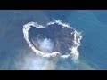
quote:The new island continues to erupt and grow, increasing its chances of long-time survival by the day. The active vent on the islet continues to be in strombolian eruption and has by now built a new cone that is higher than the main island itself (which is 38 m).
Lava flows have significantly enlarged the island to the SE where a plateau is being built. During the 10 days, it has more than doubled its surface.
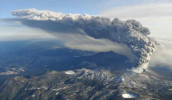
twitter:NewsBreaker twitterde op woensdag 04-12-2013 om 21:16:00 WOW!: Russia's Klyuchevskoy volcano sends pillar of fire 1,000m into the sky http://t.co/xjc9WMudV2 via @pourmecoffee http://t.co/NlyIkV9V7M reageer retweet
 WOW!: Russia's Klyuchevskoy volcano sends pillar of fire 1,000m into the sky

Zie een paar posts boven je... dat verhaaltje klopt dus nietquote: [ afbeelding ]twitter:NewsBreaker twitterde op woensdag 04-12-2013 om 21:16:00 WOW!: Russia's Klyuchevskoy volcano sends pillar of fire 1,000m into the sky http://t.co/xjc9WMudV2 via @pourmecoffee http://t.co/NlyIkV9V7M reageer retweet
O verrekquote:Op donderdag 5 december 2013 08:30 schreef Frutsel het volgende:
[..]
Zie een paar posts boven je... dat verhaaltje klopt dus niet
quote:Mount Marapi erupts
The Volcanology and Geological Disaster Mitigation Center (PVMBG) Bukittinggi reported that Mount Marapi, which lies between Tanah Datar and Agam regencies, West Sumatra, erupted at 10:10 a.m., on Sunday.
“The volcano's eruption spewed a column of thick, gray ash 350 meters high,” PVMBG official Warseno said on Sunday as quoted by Antara news agency.
Mt. Marapi’s alert level has been maintained at waspada or caution (level 2). The PVMBG has said it is not safe to be within 3 kilometers of the activity.
Increased volcanic activity was noted on Aug. 3, 2011 with an eruption and a volcanic ash cloud that covered several areas, including Agam, Padang Panjang, Padang Pariaman and Tanah Datar.
Mt. Marapi, which is located near to the twin volcanos of Mt.Singgalang and Mt. Tandikek, is a popular climbing destination, particularity during December as scores of climbers flock to its accessible peak to see in the New Year.
Marapi Wildlife Reserve is an administrative area around the volcano that is managed by the West Sumatra administration for the purposes of conservation in the province.(ebf)

De Indonesische vulkanologische dienst (VSI) meldt, dat de seismische activiteit van de Sinabung in de afgelopen dagen aanzienlijk berhoogd is. Aan de oppervlakte is de vulkaan relatief rustig. Uit de krater is enkel een gaspluim met enige asdeeltjes waarneembaar. De aardbevingen suggeren, dat nieuwe magma aan het stijgen is en mogelijk (grote) explosies kan veroorzaken. De bevingen met een lage frequentie, de zogenaamde hybride aardbevingen, zijn karakteristiek voor beweging van vloeistof binnen de vulkaan. Het aantal van deze bevingen is gestegen naar 1000 per dag. Tevens zijn er aanhoudende vulkanische trillingen (interne vibratie) op de middenniveaus geregistreerd. Deformatie metingen met tilt-meters op de noordelijke en oostelijke flanken en EDM (elektronische afstand meters) laten een fluctuerende trend van inflatie zien. Dit houdt in, dat er een massa magma zich binnendringt op geringe diepte. De gevarenzone is uitgebreid naar een radius van 5 km. De vulkaan blijft op het hoogste alertheidsniveau. De luchtvaartcode blijft eveneens rood.
I give myself very good advice
But I very seldom follow it
That explains the trouble that I'm always in
But I very seldom follow it
That explains the trouble that I'm always in

En een website met de totaal foute titel van het jaar:
http://www.wunderground.c(...)no-eruption-20131228
De titel heeft het over El Hierro. Maar het gaat over de uitbarsting van El Salvador.
Ze hebben er wel erg veel mooie plaatjes bij van andere vulkaan uitbarstingen. Dat dan weer wel.
http://www.wunderground.c(...)no-eruption-20131228
De titel heeft het over El Hierro. Maar het gaat over de uitbarsting van El Salvador.
Ze hebben er wel erg veel mooie plaatjes bij van andere vulkaan uitbarstingen. Dat dan weer wel.
<a href="http://goo.gl/q8fhTe" target="_blank">FAQ?</a>
<a href="http://goo.gl/gYvZFq" target="_blank">Geel is een zonnige en vrolijke kleur, als hij tenminste enigszins warm is gekleurd en wat naar het oranje neigt</a>
<a href="http://goo.gl/gYvZFq" target="_blank">Geel is een zonnige en vrolijke kleur, als hij tenminste enigszins warm is gekleurd en wat naar het oranje neigt</a>

Video is helaas door de gebruiker offline gehaaldtwitter:eruptionsblog twitterde op zondag 29-12-2013 om 23:19:54 Looks like the opening salvo of the San Miguel eruption was captured on video. via @chematierra and @tcsnoticias http://t.co/YKE8R0nfLR reageer retweet
 Looks like the opening salvo of the San Miguel eruption was captured on video. via @
twitter:rudigerescobar twitterde op maandag 30-12-2013 om 03:35:50 @eruptionsblog here are the seismic records from today´s activity at San Miguel: http://t.co/fjZLk6lKCY reageer retweet
 @eruptionsblog here are the seismic records from today´s activity at San Miguel:
 twitter:eruptionsblog twitterde op zondag 29-12-2013 om 22:56:12 San Miguel post updated again with OMI sulfur dioxide imagery and a link to a GOES animated GIF of the plume: http://t.co/KkLDtRmC27 reageer retweet
twitter:ejhughes1 twitterde op zondag 29-12-2013 om 22:38:57 @eruptionsblog View of San Miguel SO2 http://t.co/MbxCWwaPcm and Ash http://t.co/Xn15NSiLFm from Aura/OMI reageer retweet
 @eruptionsblog View of San Miguel SO2
<a href="http://goo.gl/q8fhTe" target="_blank">FAQ?</a>
<a href="http://goo.gl/gYvZFq" target="_blank">Geel is een zonnige en vrolijke kleur, als hij tenminste enigszins warm is gekleurd en wat naar het oranje neigt</a>
<a href="http://goo.gl/gYvZFq" target="_blank">Geel is een zonnige en vrolijke kleur, als hij tenminste enigszins warm is gekleurd en wat naar het oranje neigt</a>
quote:Paniek na hevige uitbarsting vulkaan Sinabung
Omwonenden van de zeer actieve Indonesische vulkaan Sinabung zijn zondag gevlucht nadat de berg nog heviger was uitgebarsten dan de afgelopen dagen. Zaterdag waren er liefst 50 erupties, maar zondag spuwde de berg zijn aswolken nog verder dan verwacht, meldden Indonesische media. .
Op motoren en in vrachtwagens sloegen de bewoners van de omliggende dorpen in paniek op de vlucht. De veiligheidszone rond de vulkaan op het eiland Sumatra is inmiddels 7 kilometer. De dorpen daarbinnen zijn bedekt met grijze as. De 2460 meter hoge vulkaan slingert as, puin en stenen de lucht in die in de verre omtrek neerkomen. Sinds november zijn al meer dan 20.000 omwonenden geëvacueerd.
And what rough beast, its hour come round at last,
Slouches towards Bethlehem to be born?
Slouches towards Bethlehem to be born?
Mag je hier wel ff in zetten als je wilt Perrinquote:
WKN / Indonesische vulkaan Sinabung barst in korte tijd negen keer uit
Ah, dat topic had ik gemist. Is dus al maanden bezig, die uitbarstingquote:Op zondag 5 januari 2014 12:15 schreef Frutsel het volgende:
[..]
Mag je hier wel ff in zetten als je wilt Perrin
WKN / Indonesische vulkaan Sinabung barst in korte tijd negen keer uit
And what rough beast, its hour come round at last,
Slouches towards Bethlehem to be born?
Slouches towards Bethlehem to be born?
quote:Ash explosions at Mt. Marapi on Sumatra
Bukittinggi, West Sumatra (ANTARA News) - Mount Marapi in West Sumatra expelled thin grey smoke up to 200 meters from the crater into the sky, on Wednesday morning, stated spokesman of the Bukittinggi Volcanology and Geological Disaster Mitigation Agency (PVBMG) Warseno.
"The volcano spewed smoke after it showed signs of increased activity at 7.28 a.m. local time on Wednesday. Local residents should therefore, continue to stay alert," he warned.
The volcano, located in the Tanahdatar and Agam districts, West Sumatra, remains on the second highest alert level.
People living within 3-km radius of the crater are banned from climbing the volcano.
Mt Marapi is one of the active volcanoes in West Sumatra. It had sent out sulfuric volcanic ash, one thousand meters into the sky, on August 3, 2011. The ash had fallen over several areas, such as Agam, Tanahdatar, Padangpariaman and Padangpanjang.
The volcano is also considered a conservation area as well as a tourist destination in West Sumatra.
When inactive, the mountains adjacent to Mount Singgalang and Mount Tandikek have always been a destination for climbers from within and outside West Sumatra. During every New Year, it is gets crowded with trekkers.
quote:North Sumatra’s Mount Toba may erupt again, at any time
Geologists and geophysicists say that Mount Toba, which erupted thousands of years ago, turning into Lake Toba, still contains a dangerous magma chamber and its activity needs further study.
Indonesia Geological Experts Association president Rovicky Dwi Putrohari said the magma chamber could be observed in a study conducted by researchers recently. Rovicky added that researchers used the tomography method to detect the magma chamber.
Researchers said the Mount Toba magma chamber was located at a depth of between 20 kilometers and 100 kilometers.
“The method was used in the early stage of the study. Our researchers were able to find the location and dimensions of the magma chamber of Mount Toba. Later research will find out the potential volume of magma in the volcano for triggering an eruption,” Rovicky told The Jakarta Post on the sidelines of a joint conference between the Indonesian Geological Experts Association and Indonesian Geophysics Experts Association in Medan, North Sumatra, recently.
Around 800 geologists and geophysicists took part in the conference, including scientists from Australia, France, Malaysia, Singapore and the United States.
Rovicky said that during the three-day conference several studies related to the Mount Toba eruption were presented by experts, including Craig A. Chesner, from the Eastern Illinois University in the US.
Rovicky explained that based on Chesner’s study in 2011, it was concluded that the current Lake Toba was the result of four previous eruptions.
The first eruption took place around 1.2 million years ago at the northwest end of Lake Toba, the second was around 840,000 years ago south of Lake Toba, encompassing Parapat and Porsea, the third eruption occurred around 500,000 years ago at the northern end of the lake between Silalahi and Haranggaol, and the fourth eruption occurred some 74,000 years ago which resulted in the present state of Lake Toba, with Samosir Island in the middle. Its depth is estimated at 500 meters.
Rovicky said Mount Toba was regarded as a super volcano as it had a huge magma chamber, which, if it erupted, would leave a massive caldera, like Lake Toba today.
Rovicky added that the magma chamber inside the volcano could erupt any time if the Sumatra fault line reactivated.
The Sumatra fault line bisects Sumatra Island from the northwest in Aceh to the south in Lampung. The fault line runs through Mount Toba.
“A quake could reactivate the magma chamber which is so far dormant. That’s why we believe Mount Toba could erupt again at any time. When it will be, we don’t know. Thorough and continuous research is needed to find that out,” said Rovicky.
Andi M. Adiwinata, from the Indonesian Geophysics Experts Association, said the scientist who detected the presence of the magma chamber in Mount Toba was Sri Widyantoro, from the Bandung Institute of Technology. Andi added that the detection was carried out using the tomographic technique.
Andi said Mount Toba had currently attracted the attention of local as well as foreign researchers thanks to its massive and devastating eruptions in history. He said a joint team of Indonesian scientists had been formed from relevant institutions, including the Indonesian Institute of Sciences (LIPI) and the Meteorology, Geophysical and Climatology Agency (BMKG), to conduct mitigation studies regarding the latest condition of Mount Toba.
“The researchers are currently working to find out how big the potential threat from Mount Toba is. Despite being categorized as inactive, its development needs further monitoring,” said Andi, adding that besides Mount Toba, 129 active volcanoes in Indonesia were also being monitored.

quote:Shishaldin Volcano's Alert Status Upgraded After Unusual Activity
The Alaska Volcano Observatory upgraded the alert level at Shishaldin Volcano in the Aleutian Islands Thursday after seeing some unrest at the summit.
AVO scientist Kristi Wallace says the unusual activity at Shishaldin began Wednesday.
"Little bit ago, AVO changed the color code at Shishaldin from green to yellow based on increased temperatures at the summit crater of Shishaldin Volcano as well as increased steaming yesterday," she says. "Both of those observations were observed via satellite imagery.
Wallace says the observations don’t mean Shishaldin is in imminent danger of eruption. The yellow status just indicates behavior that isn’t normal.
Shishaldin is the highest peak in the Aleutians, rising about 9,400 feet above sea level. It’s located on Unimak Island about 100 miles northeast of Unalaska.
Shishaldin was last elevated to yellow in 2009, when the same kind of activity occurred. Wallace says that anomaly didn’t result in anything more serious.
Historically, though, Shishaldin has been very active:
"It’s erupted approximately 28 times since 1775, so in historic times it’s erupted quite frequently, although the eruptions are typically low-level plumes and ash and steam plumes," Wallace says. "So [it's] not a particularly dangerous volcano, although the eruption that occurred in 1999 did send ash plumes as high as 45,000 feet above sea level."
Wallace says the AVO is going to keep monitoring Shishaldin for signs of explosions. But the seismic stations closest to the summit aren’t working right now. That means using more distant monitoring points as their main sources of data.
"There’s a whole network of stations, so we’re just relying on other stations that are not quite as close to the summit area where we’re seeing the activity," Wallace says. "Hopefully those will be enough for us to pick up a seismic signal, although this volcano’s not just monitored with a seismic network. We’re still using satellite imagery, and then the infrasound stations which are good at detecting explosion signals."
There are two other volcanoes in the Aleutians currently on a yellow alert. Those are Cleveland, 175 miles southwest of Unalaska, and Veniaminof, northeast of King Cove.
Een uitbarsting van de vulkaan Kelud op het Indonesische eiland Java heeft donderdag duizenden mensen op de vlucht doen slaan.
Foto: AFP
De vulkaan spuwt as en gesteente tot een hoogte van drie kilometer de lucht in, meldden de hulpdiensten in het land.
De uitbarsting begon 's middags. Met hulp van de autoriteiten of op eigen houtje maakten inwoners uit de omgeving zich zo snel mogelijk uit de voeten. De overheid heeft mensen in een straal van 10 kilometer van de vulkaan dringend aangeraden het gebied te verlaten. Voor zover bekend zijn er geen slachtoffers te betreuren.
http://www.nu.nl/buitenla(...)luchten-vulkaan.html
Thx! Effe eigen topic aangemaaktquote:
WKN / Duizenden Javanen op de vlucht voor vulkaan Kelud, luchthavens dicht
quote:Remote Alaska volcano might erupt soon, experts say
Alaska's Cleveland Volcano could soon be leaking from its flanks if the lava inside continues to build up, officials at the Alaska Volcano Observatory reported.
The observatory reported that the volcano's lava dome was 262 feet in diameter on August 30 and has now expanded to 394 feet.
"The presence of the lava dome increases the possibility of an explosive eruption, but does not necessarily indicate that one will occur," the observatory said. "Short-lived explosions could produce an ash cloud that exceeds 20,000 ft above sea level."
The observatory said it did not expect air travel problems if the volcano erupted.
Because "the small lava dome in the summit crater has resumed growth and now fills the floor of the crater," the observatory is raising its alert level.
The remote volcano is in the Aleutian Islands, about 940 miles southwest of Anchorage.
Because the volcano is in such a remote area, the observatory webcam feed has experienced technical difficulties.
Ook even hier omdat hij zo mooi is... 
Ecuador
zie ook:
WKN / Uitbarsting vulkaan Tungurahua in Ecuador
Ecuador

zie ook:
WKN / Uitbarsting vulkaan Tungurahua in Ecuador
quote:Magma rising in Washington state's Mount St. Helens volcano
(Reuters) - Magma levels are slowly rebuilding inside Mount St. Helens, a volcano in Washington state that erupted in 1980 and killed 57 people, although there was no sign of an impending eruption, U.S. scientists said.
The roughly 8,300-foot volcano erupted in an explosion of hot ash and gas on May 18, 1980, spewing debris over some 230 square miles and causing more than a billion dollars in property damage. Entire forests were crushed and river systems altered in the blast, which began with a 5.2 magnitude earthquake.
"The magma reservoir beneath Mount St. Helens has been slowly re-pressurizing since 2008," the U.S. Geological Survey said in a statement on Wednesday. "It is likely that re-pressurization is caused by (the) arrival of a small amount of additional magma 4 to 8 km (2.5 to 5 miles) beneath the surface."
The USGS said this is to be expected with an active volcano and does not indicate "the volcano is likely to erupt anytime soon."
The USGS, and the Pacific Northwest Seismic Network at University of Washington, closely monitor ground deformation and seismicity at the volcano. This summer, they will also measure its released gases and gravity field, measurements that can be used to monitor subsurface magma and forecast eruptions.
Alleen heeft wired een mogelijk probleem waardoor je een foutmelding pagina krijgt/kunt krijgen.twitter:eruptionsblog twitterde op donderdag 01-05-2014 om 16:46:51 Brief updates today for activity at Mount St. Helens and a possible submarine eruption at Ahyi in the Marianas: http://t.co/ONotMIXbdJ reageer retweet
 Brief updates today for activity at Mount St. Helens and a possible submarine eruption at Ahyi in the Marianas:
<a href="http://goo.gl/q8fhTe" target="_blank">FAQ?</a>
<a href="http://goo.gl/gYvZFq" target="_blank">Geel is een zonnige en vrolijke kleur, als hij tenminste enigszins warm is gekleurd en wat naar het oranje neigt</a>
<a href="http://goo.gl/gYvZFq" target="_blank">Geel is een zonnige en vrolijke kleur, als hij tenminste enigszins warm is gekleurd en wat naar het oranje neigt</a>
quote:Evacuations near volcano in El Salvador
At least 1,000 people living near the Chaparrastique volcano have been evacuated as a precautionary measure after seismic activity increased at the volcano, Salvadoran civil protection authorities said Monday.
There was an explosion early Monday and the volcano then spewed reddish ash, officials said.
The Civil Protection Department said in a statement that an alert had been declared for the municipality of San Miguel, where the volcano is located. The city of San Miguel itself is 50 kilometres from the volcano. It is one of the largest cities in the Central American country.
The 2,129-metre volcano is about 145 kilometres east of San Salvador, the capital of El Salvador.
The volcano's last significant eruption was in 1976.

De Bromo is de bekendste vulkaan op het eiland Java, Indonesië.

🌳♪💻🌳🌳🌲
Peace Love
2c Ondertiteling activeren als deze beschikbaar is. Druk nogmaals op C om de ondertiteling te verbergen.
3. Ambient modern
Peace Love
2c Ondertiteling activeren als deze beschikbaar is. Druk nogmaals op C om de ondertiteling te verbergen.
3. Ambient modern
Ik dacht de Merapi?quote:Op donderdag 29 mei 2014 11:53 schreef Treehut362 het volgende:
De Bromo is de bekendste vulkaan op het eiland Java, Indonesië.
[ afbeelding ]
mijn vader is er geweestquote:
 Op
Op
🌳♪💻🌳🌳🌲
Peace Love
2c Ondertiteling activeren als deze beschikbaar is. Druk nogmaals op C om de ondertiteling te verbergen.
3. Ambient modern
Peace Love
2c Ondertiteling activeren als deze beschikbaar is. Druk nogmaals op C om de ondertiteling te verbergen.
3. Ambient modern
voor mij wel, trouwens ik heb het van Wikipediaquote:
🌳♪💻🌳🌳🌲
Peace Love
2c Ondertiteling activeren als deze beschikbaar is. Druk nogmaals op C om de ondertiteling te verbergen.
3. Ambient modern
Peace Love
2c Ondertiteling activeren als deze beschikbaar is. Druk nogmaals op C om de ondertiteling te verbergen.
3. Ambient modern
twitter:eruptionsblog twitterde op vrijdag 30-05-2014 om 14:35:08 Explosive eruption today at Indonesias Sangeang Api, with a plume that might be 20 km tall (or more): http://t.co/aj86AKZNlR reageer retweet

<a href="http://goo.gl/q8fhTe" target="_blank">FAQ?</a>
<a href="http://goo.gl/gYvZFq" target="_blank">Geel is een zonnige en vrolijke kleur, als hij tenminste enigszins warm is gekleurd en wat naar het oranje neigt</a>
<a href="http://goo.gl/gYvZFq" target="_blank">Geel is een zonnige en vrolijke kleur, als hij tenminste enigszins warm is gekleurd en wat naar het oranje neigt</a>
Flinke pluim.quote:[ afbeelding ]twitter:eruptionsblog twitterde op vrijdag 30-05-2014 om 14:35:08 Explosive eruption today at Indonesias Sangeang Api, with a plume that might be 20 km tall (or more): http://t.co/aj86AKZNlR reageer retweet
twitter:teideano twitterde op vrijdag 30-05-2014 om 19:31:49 La erupción de Sangeang vista desde el mar. Impresionante columna eruptiva. http://t.co/0Ec7lq7nvg reageer retweet
 La erupción de Sangeang vista desde el mar. Impresionante columna eruptiva.
twitter:ObservingSpace twitterde op zaterdag 31-05-2014 om 02:08:34 MT @teideano The view of the #Sangeang eruption from the sea. Impressive #eruption column. #volcano #indonesia http://t.co/tOAgXIdjXy reageer retweet
 MT @
MT @
twitter:eruptionsblog twitterde op zaterdag 31-05-2014 om 05:14:00 I apologize for the Daily Mail link, but the images of the Sangeang Api eruption are great.http://t.co/qgqg90WiPk http://t.co/75BhP36Oly reageer retweet
twitter:VolcanoReport twitterde op zaterdag 31-05-2014 om 10:49:38 Powerful #eruption of the #Sangeang Api #volcano, #Indonesia - http://t.co/r83nT6Linz http://t.co/ulETUd6Fnq reageer retweet


[ Bericht 14% gewijzigd door bwt op 31-05-2014 12:58:51 ]
<a href="http://goo.gl/q8fhTe" target="_blank">FAQ?</a>
<a href="http://goo.gl/gYvZFq" target="_blank">Geel is een zonnige en vrolijke kleur, als hij tenminste enigszins warm is gekleurd en wat naar het oranje neigt</a>
<a href="http://goo.gl/gYvZFq" target="_blank">Geel is een zonnige en vrolijke kleur, als hij tenminste enigszins warm is gekleurd en wat naar het oranje neigt</a>
"Light thinks it travels faster than anything. It doesn't. For wherever light travels it finds darkness has got there first and is waiting for it."
twitter:RT_com twitterde op zaterdag 31-05-2014 om 17:30:46 Indonesia volcano ash cloud stops all air services to Darwin & Bali, grounds Australia flights http://t.co/cYAn7pBzSW http://t.co/OLGkcs09Fn reageer retweet
 Indonesia volcano ash cloud stops all air services to Darwin & Bali, grounds Australia flights
 twitter:Matthew__Watson twitterde op zaterdag 31-05-2014 om 19:29:27 Breathtaking..."@Bromotengger: Stunning pic of the the #eruption of the #SangeangApi #volcano in #Indonesia http://t.co/5tNOG5L7ZL” reageer retweet
 Breathtaking..."@Bromotengger: Stunning pic of the the
<a href="http://goo.gl/q8fhTe" target="_blank">FAQ?</a>
<a href="http://goo.gl/gYvZFq" target="_blank">Geel is een zonnige en vrolijke kleur, als hij tenminste enigszins warm is gekleurd en wat naar het oranje neigt</a>
<a href="http://goo.gl/gYvZFq" target="_blank">Geel is een zonnige en vrolijke kleur, als hij tenminste enigszins warm is gekleurd en wat naar het oranje neigt</a>

Van Nasa Earth Observatory website
En :

van Eruptions blogger - prof. Erik Klemetti
Plaatje laat zien dat de as wolk tot in australie komt. (en dat was een paar dagen terug)
<a href="http://goo.gl/q8fhTe" target="_blank">FAQ?</a>
<a href="http://goo.gl/gYvZFq" target="_blank">Geel is een zonnige en vrolijke kleur, als hij tenminste enigszins warm is gekleurd en wat naar het oranje neigt</a>
<a href="http://goo.gl/gYvZFq" target="_blank">Geel is een zonnige en vrolijke kleur, als hij tenminste enigszins warm is gekleurd en wat naar het oranje neigt</a>

quote:Alaska Pavlof Volcano Erupts: Alert Level At Orange
The Alaska Volcano Observatory (AVO) issued a red alert warning this week when the Pavlof Volcano shifted into an intense eruption, sending ash 22,000 feet into the air.
Pavlof is located in an uninhabited region of the Alaska Peninsula, 625 miles southwest of Anchorage.
This is the state's first red alert since 2009, Reuters reports, when Mount Redoubt sent ash flying 50,000 feet into the air, disrupting air traffic.
This week's eruption didn't aggravate airline activity.
Pavlof's alert level was slightly lowered to Orange by late Tuesday because seismic tremors had decreased for the past 12 hours, but scientists are still watching the volcano closely.
"It can erupt for weeks or months," observatory research geologist Michelle Coombs told Reuters.
The event over the weekend was unusual because scientists did not initially detect elevated seismicity below the mountain. Instead, scientists using satellite signals detected elevated surface temperatures late Friday afternoon.
A lava flow began from a vent on the north side of the mountain a few hundred meters from the peak, and scientists began to see plumes heading to the east and northeast at 9,000 to 10,000 feet.
Around 3 p.m. Monday, there was a considerable uptick in seismicity, according to Game McGimsey, a volcanologist at the observatory, prompting the red warning alert.

Gisteren die 8.0 aardbeving in dezelfde regio... "a larger process at work" ?quote:Volcanoes are waking up in the Aleutians
Sharply increased seismic activity and volcanic eruptions in the Aleutian Islands and the far western Brooks Range are being investigated by scientists.
The Alaska Volcano Observatory says the activity over the past few months is the most seen by the station 26 years.
On the Alaska Volcano Observatory website three volcanoes are classified with a yellow alert level—signifying signs of elevated unrest above known background levels—and three are at an orange alert level—heightened unrest with increased likelihood of eruption.
Orange is the second-highest alert level after red signifying an eruption that is imminent or underway.
Pavlof Volcano released an ash plum in May that diverted aircraft. The 8,262-foot (2,518-meter) tall volcano erupted sending ash plumes as high as 30,000 feet (9,144 meters). Aircraft were advised to avoid the area since ash could damage airplane engines.
With heightened activity from all volcanoes, scientists still don't have enough information to point to any larger trend or activity.
"At this point, you know, we have to say it’s coincidental," he said in an interview with radio station KTOO News.
"It could be that there is a larger process at work, but we’re not able to say what that is at this point in time, or if there is such a process. You know, perhaps the answer is we haven’t been looking long enough to know."
The government agency posted news updates on its Facebook page today showing elevated surface temperatures at the summit of Shishaldin Volcano.
Sinabung is weer onrustig:
twitter:teideano twitterde op maandag 30-06-2014 om 14:24:09 Sinabung erupts again un Indonesia, prompting massive evacuations. #volcano #science #nature http://t.co/YqgYoiMTl7 reageer retweet

<a href="http://goo.gl/q8fhTe" target="_blank">FAQ?</a>
<a href="http://goo.gl/gYvZFq" target="_blank">Geel is een zonnige en vrolijke kleur, als hij tenminste enigszins warm is gekleurd en wat naar het oranje neigt</a>
<a href="http://goo.gl/gYvZFq" target="_blank">Geel is een zonnige en vrolijke kleur, als hij tenminste enigszins warm is gekleurd en wat naar het oranje neigt</a>


The only limit is your own imagination
Ik ben niet gelovig aangelegd en maak daarin geen onderscheid tussen dominees, imams, scharenslieps, autohandelaren, politici en massamedia
Waarom er geen vliegtuig in het WTC vloog
Ik ben niet gelovig aangelegd en maak daarin geen onderscheid tussen dominees, imams, scharenslieps, autohandelaren, politici en massamedia
Waarom er geen vliegtuig in het WTC vloog

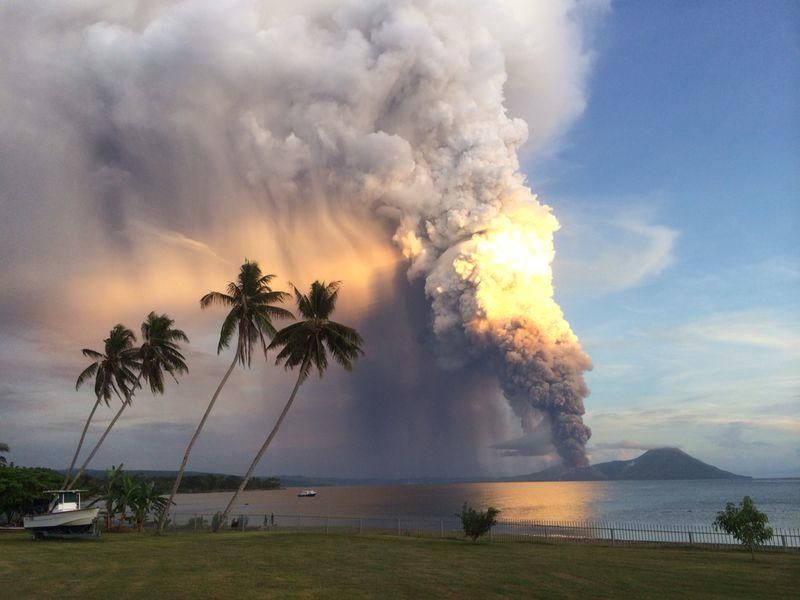
twitter:Bromotengger twitterde op vrijdag 04-07-2014 om 13:20:54 #Tavurvur #volcano in #PapuaNewGuinea #erupting few hours ago http://t.co/3XdyiHEXyV reageer retweet


<a href="http://goo.gl/q8fhTe" target="_blank">FAQ?</a>
<a href="http://goo.gl/gYvZFq" target="_blank">Geel is een zonnige en vrolijke kleur, als hij tenminste enigszins warm is gekleurd en wat naar het oranje neigt</a>
<a href="http://goo.gl/gYvZFq" target="_blank">Geel is een zonnige en vrolijke kleur, als hij tenminste enigszins warm is gekleurd en wat naar het oranje neigt</a>
En het is drukker op La Reunion
Piton de la Fournaise volcano erupted
Ivm slecht weer zijn de beelden van de webcams niet 100%
Piton de la Fournaise volcano erupted
Ivm slecht weer zijn de beelden van de webcams niet 100%
quote:- It is currently bad weather at the summit of the volcano. During better weather you can see a number of live webcam images here
The eruption is not spectacular but shows 2 craters in eruption + a number of lava streams slowly finding their way (to the ocean?). They appear not to be powerful enough to reach the ocean. Neither can lava tubes be seen. The volcano has a lot of lava tubes and eruptions regularly reach the ocean (Hawaii type of eruptions).
The volcano was set to a higher alert on June 12 after seismicity started to increase. People were had to stay on prepared trails. Good work from the volcanologists!
<a href="http://goo.gl/q8fhTe" target="_blank">FAQ?</a>
<a href="http://goo.gl/gYvZFq" target="_blank">Geel is een zonnige en vrolijke kleur, als hij tenminste enigszins warm is gekleurd en wat naar het oranje neigt</a>
<a href="http://goo.gl/gYvZFq" target="_blank">Geel is een zonnige en vrolijke kleur, als hij tenminste enigszins warm is gekleurd en wat naar het oranje neigt</a>
quote:San Cristobal (El Salvador) unleashes steam and ash
At about 1:50 pm the San Cristobal volcano, located in the department of Chinandega reported an explosion, according to El Nuevo Diario reported Maj. Carlos Caceres Mendoza, departmental head of the Civil Defense in this department, where also several people managed see a column of smoke between 80 to 100 meters, throwing colossus material between ash and sand.
Neighbors sector of the region "The Greece 1, 2 and 3" were observed ash and fine sand that fell on the road, thrown by the volcano as well as residents of the estates "La Roja", "Flags", near to San Cristobal.
In this situation, the Civil Defense Chinandega is under continuous observation of the volcano who informed that this is a gasification process of the Colossus and watch him be for any damage that may be caused in the regions close to San Cristobal.
twitter:teideano twitterde op dinsdag 22-07-2014 om 12:07:59 Extreme vibration at San Miguel #volcano in El Salvador. Increíble el estado sísmico del #volcàn San Miguel. #science http://t.co/n624Sybi8k reageer retweet
twitter:eruptionsblog twitterde op zaterdag 16-08-2014 om 14:06:06 As reported by a number of people, Bárdarbunga in Iceland is up to something - intrusion? Headed to eruption? http://t.co/MpfDZdf7WV reageer retweet
twitter:eruptionsblog twitterde op zaterdag 16-08-2014 om 14:06:39 I have no idea but well worth watching. reageer retweet


<a href="http://goo.gl/q8fhTe" target="_blank">FAQ?</a>
<a href="http://goo.gl/gYvZFq" target="_blank">Geel is een zonnige en vrolijke kleur, als hij tenminste enigszins warm is gekleurd en wat naar het oranje neigt</a>
<a href="http://goo.gl/gYvZFq" target="_blank">Geel is een zonnige en vrolijke kleur, als hij tenminste enigszins warm is gekleurd en wat naar het oranje neigt</a>
IJslandse vulkanen staan ook hier:
WKN / [ACTUEEL] Vulkanen IJsland #18: Verhoogde activiteit bij Katla
WKN / [ACTUEEL] Vulkanen IJsland #18: Verhoogde activiteit bij Katla
twitter:AFP twitterde op dinsdag 19-08-2014 om 15:28:02 Japan volcanic isle may collapse, create tsunami http://t.co/8q3H6VBpxE http://t.co/V8z8P4PLUG reageer retweet
 Japan volcanic isle may collapse, create tsunami
(googlemaps)
Gaat om een groeiende vulkaan die dagelijks veel lava en as uitstoot.
Dit is inmiddels dusdanig gegroeit dat een deel in elkaar kan storten met al dan niet een tsunami tot gevolg.
<a href="http://goo.gl/q8fhTe" target="_blank">FAQ?</a>
<a href="http://goo.gl/gYvZFq" target="_blank">Geel is een zonnige en vrolijke kleur, als hij tenminste enigszins warm is gekleurd en wat naar het oranje neigt</a>
<a href="http://goo.gl/gYvZFq" target="_blank">Geel is een zonnige en vrolijke kleur, als hij tenminste enigszins warm is gekleurd en wat naar het oranje neigt</a>


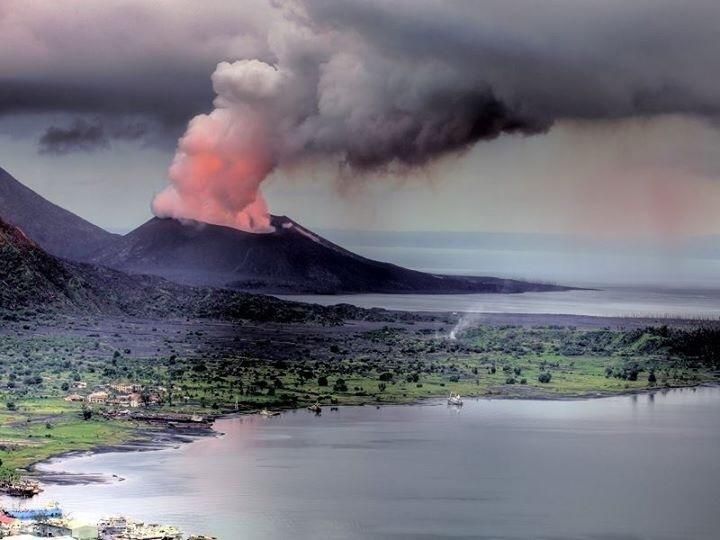
Tavurvur volcano (Rabaul, Papua New Guinea): large explosive eruption, ash to 60,000 ft
A large explosive eruption began at Tavurvur volcano (Rabaul caldera) this morning.
The eruption seems to be similar to a paroxysm on Etna.
Lava fountains and significant ash emissions were observed. The ash plume reached a height of approx. 60,000 ft (18 km) altitude. Aviation color code was raised to red.


de plaat is echt vet!quote:
Inorbit: zeg dat dan typluie triangeljosti
Beauregard: Een beetje FOK!ker laat het brood door z'n moeder smeren.
Ecosia
ek's 'n flash drive, jy's 'n floppy
Beauregard: Een beetje FOK!ker laat het brood door z'n moeder smeren.
Ecosia
ek's 'n flash drive, jy's 'n floppy
![Volcano Erupts In Mount Tavurvur Papua New Guinea Spewing Ash Lava [Incredible]](http://i.ytimg.com/vi/h1ivE6LGh3M/default.jpg)
wow
DeLuna vindt me dik ;(
Op zondag 22 juni 2014 12:30 schreef 3rdRock het volgende:
pas als jullie gaan trouwen. nu ben je gewoon die Oom Rubber die met onze mama leuke dingen doet :)
Op zondag 22 juni 2014 12:30 schreef 3rdRock het volgende:
pas als jullie gaan trouwen. nu ben je gewoon die Oom Rubber die met onze mama leuke dingen doet :)
New Guineau..
Vulkaan spuwt tot 18 km hoogte as de lucht in.
[ Bericht 11% gewijzigd door #ANONIEM op 30-08-2014 12:23:30 ]
Vulkaan spuwt tot 18 km hoogte as de lucht in.
[ Bericht 11% gewijzigd door #ANONIEM op 30-08-2014 12:23:30 ]
Never Mind Iceland — This Erupting Volcano Is the Real Threat
http://mashable.com/2014/(...)guinea-mount-rabaul/
http://mashable.com/2014/(...)guinea-mount-rabaul/

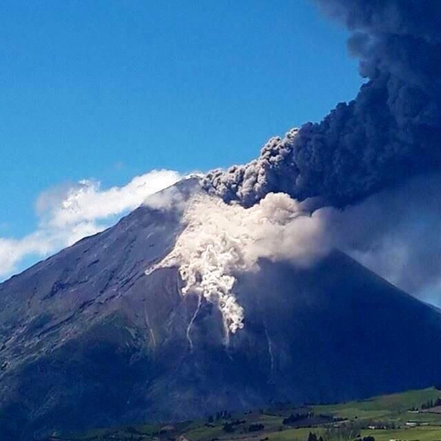
#Pyroclastic #flows at #Tungurahua #volcano #Ecuador. The activity remains high http://t.co/O9XDqxMjyk

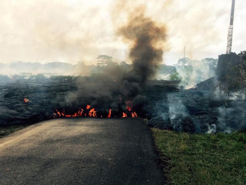
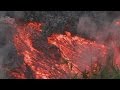
quote:Lava Continues to Flow from Volcano Kilauea
Islands, is oozing out lava. But Big Island Civil Defense officials who flew over the lava flow on Monday stated that there is no immediate threat.
"It's very slow. The surface flow, whenever it's on the surface, has been very, very slow moving and that's why we're saying it's not posing any imminent threat", affirmed Darryl Oliveira, Big Island Civil Defense director.
Till now, the lava is not moving through rapidly and also, it is not a stream of lava. Lava is around 1.2 miles from the eastern boundary of the Wao Kele O Puna forest reserve. For now, people residing nearby have not been asked to evacuate their respective places.
Right now, the situation is under control. And, even if there will be a need to evacuate the region, residents will be having sufficient time to do the same.
In 1983, Kilauea erupted for the first time. Since then, continuous eruptions have been taking place. Experts shared that main concern is since its first eruption, new openings have been forming. On June 27, a new vent was formed and through these vents, lava reaches the surface.
Authorities concerned said that people around the area are regularly updated about the situation. They are well aware that the current situation will not affect their homes. Scientists have been keeping a check on the vent, as it can prove problematic in the coming time.
Researchers have not been able to come to know the exact path of the lava flow. As per scientists, changes in the amount of flow have been acting as hurdle to know the detailed path.
Hawaii County officials made an announcement that this week two community meetings will be held. In these meetings, the latest updates on lava flow threatening residential areas will be discussed. One of the meetings will be on September 2 and another will be on September 4 from 6.30 to 8pm in Pahoa High School cafeteria.
quote:Kilauea lava flow could potentially threaten homes
Scientists at the USGS Hawaiian Volcano Observatory are closely monitoring an active lava flow that, if it continues to advance, could threaten residential areas or infrastructure in the coming weeks to months.
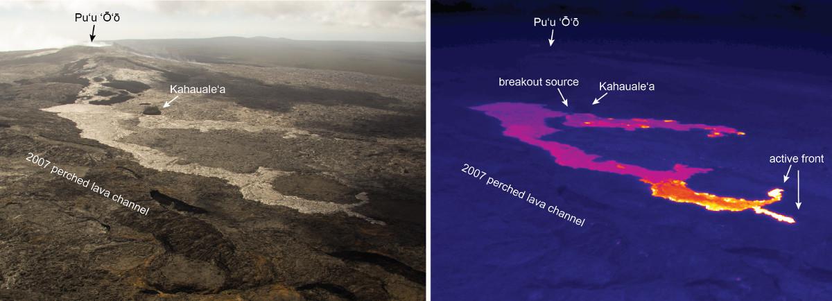
The June 27th lava flow, named for the date it began erupting, is advancing to the northeast of its vent on the flank of Pu’u ‘Ō’ō on Kīlauea Volcano’s East Rift Zone.
As of Friday, August 22, the front of the flow was 10.7 km (6.6 mi) northeast of the vent. At this point, scientists say it is not an immediate threat.
HVO scientists, who mapped the flow during an overflight Friday morning, report that the flow was active along two fronts. The northern branch was advancing northeastward across fairly flat land, while the southern branch had flowed into a ground crack within the rift zone. By tracing the steam issuing from the crack, lava is inferred to have advanced 1.4 km (0.9 mi) over the past four days, putting it 3.8 km (2.4 mi) from the eastern boundary of the Wao Kele o Puna Forest Reserve.
The difficulty in forecasting the flow’s exact path is that “downhill of the flow” can be affected by subtle variations in topography, changes in lava supply and where and how lava enters or exits ground cracks along the rift zone.
The June 27th lava flow is advancing through a heavily forested area on Kīlauea’s East Rift Zone. This area of the rift zone is exceedingly hazardous to hikers as it is highly fractured, with numerous, deep ground cracks that are difficult to see because of the heavy vegetation. Another hazard in the area includes methane explosions that occur when lava flows over vegetated land.
The June 27th lava flow is currently within the Kahaualea Natural Area Reserve, which has been closed by the Hawaii State Department of Natural Land and Resources due to the ongoing volcanic hazards, and the Wao Kele o Puna Forest Reserve, also closed by DLNR and the Office of Hawaiian Affairs.
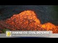
HVO continues to closely monitor the June 27th lava flow through increased overflights, satellite imagery, and webcam images, and is keeping Hawaii County Civil Defense fully informed about the flow’s location.
quote:Seismologists in Ecuador say the Tungurahua volcano is showing increased activity.
About 40 explosions were registered on Monday and even though their intensity diminished, experts have not ruled out a renewed sudden increase.
An ash cloud up to 3km (1.8 miles) in height has been rising from the volcano over the past few days.
Tungurahua, which had been dormant until 1999, lies 135km (85 miles) south-east of the capital, Quito.
Despite the increase in seismic activity, children in the area returned to class on Monday, the start of a new school year.
Resident Antonio Chango told Ecuador's El Comercio newspaper that "our children's studies can not stop just because of the volcano".
"We're fine and keen to start the school year," one young pupil told the paper.
The 5,023m-high Tungurahua, meaning "throat of fire" in the indigenous Quechua language, is one of South America's most active volcanoes.

Oeps, verkeerde topic
<a href="http://goo.gl/q8fhTe" target="_blank">FAQ?</a>
<a href="http://goo.gl/gYvZFq" target="_blank">Geel is een zonnige en vrolijke kleur, als hij tenminste enigszins warm is gekleurd en wat naar het oranje neigt</a>
<a href="http://goo.gl/gYvZFq" target="_blank">Geel is een zonnige en vrolijke kleur, als hij tenminste enigszins warm is gekleurd en wat naar het oranje neigt</a>


Bronquote:Dark giant ash clouds rise from the crater of Mount Sinabung volcano during an eruption on October 8, 2014, as seen from Karo district located on Indonesia's Sumatra island, following an earlier eruption on October 5, 2014.According to authorities hundreds of residents are still housed at evacuation centers as authorities maintains off limit danger zone around Mount Sinabung located in Indonesia's Sumatra island following deadly eruption in early February that killed about 17 people.
quote:Colombian earthquake spark tenstions about possible imminent eruptions?
Authorities in southwestern Colombia have raised alert levels on Tuesday after a 5.6 magnitude earthquake hit the border region, sparking concerns that two nearby volcanoes might erupt in a matter of days. Colombia’s Geological Service have changed the alert level of two volcanoes from yellow to orange. The two volcanoes are Cerro Negro de Mayasquer and Chiles, both active on Colombia’s southern border to Ecuador. The orange alert level is defined by the Geological Service as “probable eruption in term of days to weeks.” The earthquake that hit the border region causes a scare on both side of the border.
Officials in the Colombian town of Cumbal, near the quake’s epicenter, were quoted as saying by The Associated Press that they formed an emergency committee to survey possible damage. But so far, there were no reports of injuries in the town of 36,000 residents, the majority of them members of an indigenous tribe. “It was really strong, every house” felt it, Jose Diomedes Juezpesan, the town’s top official, told AP. If the volcanoes are to erupt, it will mostly affect the state Nariño. Local state governments have started to take security measures in order prevent tragedies. Nariño government officials have recommended suspending school classes, delivered a special communication system to indigenous communities in the area and offered the indigenous communities tents if the evacuate their premise while the volcanoes are on high alert. Neither one of the volcanoes have erupted in the past 160,000 years.
quote:Alertlevel raised at Cerro Negro
Cerro Negro de Mayasquer volcano (Colombia): magnitude 5.8 earthquake, alert level raised
Orange alert has been declared for the volcanic complex at the Colombia-Ecuador border, after a magnitude 5.8 earthquake occurred under the volcano last Monday.
This earthquake, located at shallow 10 km depth southwest of the Chiles cone, seems to be directly linked to the ongoing crisis at the volcano. The volcano has recently been showing increased signs of volcanic unrest and inflation. This could be the sign of magma rising with the volcano and result in an eruption, although it is not possible to quantify how likely this might be.
Since a seismic network had been installed in early 2013, the volcano has had two impressive peaks of earthquakes, the first one occurring between Sep 2013 and Jan 2014 with over 100,000 small events detected. A second peak with 25,000 quakes occurred between late April and July this year, when the alert level was first raised to yellow.
A new seismic swarm has started on 29 September and until now counts nearly 40,000 quakes. In addition, a slow inflation (swelling of the mountain) located southwest of the cone Chiles has been detected by scientists.
Some of the seismic activity has the characteristics believed to represent fluid (gasses, water, magma) movements at depth, although most earthquakes are related to small rock fracturing events (which could be purely tectonic in nature and not necessarily related to magma).
The volcano has only a short history of monitoring and not have any known eruption in the past 10,000 years. This makes it extremely difficult to asses how likely it is that it awakes in a near to medium future. However, Colombian and Ecuadorian scientists take the situation very seriously and have started to prepare hazard maps for various kind of possible eruption scenarios.
A special bulletin of IGEPN also states that the recorded deformation has increased in recent days. This bulletin concluded that the observed monitoring parameters are compatible with the scenario of a magma intrusion that could lead to a sudden, potentially large, phreatic or even magmatic eruption, even on a short timescale (weeks).
Whether an eruption will actually occur or not is impossible to predict.
Zie ook:quote:Update : Although we mentioned earlier that this earthquake was not linked to volcanic activity, the Carchi authorities have now confirmed that the earthquake was volcanically triggered.
Earthquake shakes Colombia - Ecuador border

Interessant Frutsel!
Je vroeg of ik er meer van weet. Globaal ja, in detail niet. Zie de vulkanen daar beschreven op Wikipedia.
En dit artikel zou je wat achtergrond kunnen geven:
http://nl.wikipedia.org/wiki/Geologie_van_Colombia
Je vroeg of ik er meer van weet. Globaal ja, in detail niet. Zie de vulkanen daar beschreven op Wikipedia.
En dit artikel zou je wat achtergrond kunnen geven:
http://nl.wikipedia.org/wiki/Geologie_van_Colombia
The only limit is your own imagination
Ik ben niet gelovig aangelegd en maak daarin geen onderscheid tussen dominees, imams, scharenslieps, autohandelaren, politici en massamedia
Waarom er geen vliegtuig in het WTC vloog
Ik ben niet gelovig aangelegd en maak daarin geen onderscheid tussen dominees, imams, scharenslieps, autohandelaren, politici en massamedia
Waarom er geen vliegtuig in het WTC vloog


Shiz@autocorrectie"Als er een nieuwsicoon staat, foto-onderschrift, elk woord goed gespeld is en quotes kloppen en er staat 'Ik heb geen het is wanneer blijkt dat gisteren voor de dag dan dat kan ik weet toe maar anders ja veel', mis ik het."
Hawaii lavastroom Mooie foto's
http://www.bostonglobe.co(...).html?p1=BP_Headline
En de lavastroom update van 3 november
http://www.bigislandvideo(...)update-monday-nov-3/
[ Bericht 42% gewijzigd door bwt op 04-11-2014 14:07:24 ]
http://www.bostonglobe.co(...).html?p1=BP_Headline
En de lavastroom update van 3 november
http://www.bigislandvideo(...)update-monday-nov-3/
twitter:davidmpyle twitterde op dinsdag 04-11-2014 om 10:51:56 The #Kilauea lava flow has stalled on the edge of #Pahoa village, but lava breakouts are widening the flow front http://t.co/5v4bo76nv4 reageer retweet
 The
The [ Bericht 42% gewijzigd door bwt op 04-11-2014 14:07:24 ]
<a href="http://goo.gl/q8fhTe" target="_blank">FAQ?</a>
<a href="http://goo.gl/gYvZFq" target="_blank">Geel is een zonnige en vrolijke kleur, als hij tenminste enigszins warm is gekleurd en wat naar het oranje neigt</a>
<a href="http://goo.gl/gYvZFq" target="_blank">Geel is een zonnige en vrolijke kleur, als hij tenminste enigszins warm is gekleurd en wat naar het oranje neigt</a>
En nog meer video's en foto's
http://www.hawaiinewsnow.(...)upslope-still-active
Lava front lijkt nog steeds stil te staan en break-outs stroom-opwaards
http://www.hawaiinewsnow.(...)upslope-still-active
Lava front lijkt nog steeds stil te staan en break-outs stroom-opwaards
<a href="http://goo.gl/q8fhTe" target="_blank">FAQ?</a>
<a href="http://goo.gl/gYvZFq" target="_blank">Geel is een zonnige en vrolijke kleur, als hij tenminste enigszins warm is gekleurd en wat naar het oranje neigt</a>
<a href="http://goo.gl/gYvZFq" target="_blank">Geel is een zonnige en vrolijke kleur, als hij tenminste enigszins warm is gekleurd en wat naar het oranje neigt</a>
Avond update
quote:This afternoon’s assessment shows that the flow front remains active however has not advanced since Thursday. All activity along the front has been limited to breakouts along the margins or sides of the flow as well as on the flow surface. The front remains approximately 480 feet from the Pahoa Village Road. Additional breakouts upslope of the flow front are being monitored and those breakouts currently do not present with an immediate threat to area residents. The upslope breakouts are located approximately .7 to 1.5 mile above the ʻApaʻa Street area and along the north side of the flow and moving in a nor/northeast direction.
<a href="http://goo.gl/q8fhTe" target="_blank">FAQ?</a>
<a href="http://goo.gl/gYvZFq" target="_blank">Geel is een zonnige en vrolijke kleur, als hij tenminste enigszins warm is gekleurd en wat naar het oranje neigt</a>
<a href="http://goo.gl/gYvZFq" target="_blank">Geel is een zonnige en vrolijke kleur, als hij tenminste enigszins warm is gekleurd en wat naar het oranje neigt</a>
Hawaii update:
quote:The leading edge of the flow remains stalled and the overall level of activity was low. However, active breakouts persist in areas upslope of the leading edge and on flow margins. USGS also observed some new activity at Pu’u O’o, detailed below.
quote:This morning’s assessment shows that the flow front remains stalled with very little activity and has not advanced over the past five days. The flow pad continues to show signs of inflation which could result in breakouts and more activity. The front remains approximately 480 feet from the Pahoa Village Road. The upslope breakouts remain approximately 0.7 to 1.50 miles above the Apa’a Street area and along the north side of the flow and moving in a north/northeast direction.
<a href="http://goo.gl/q8fhTe" target="_blank">FAQ?</a>
<a href="http://goo.gl/gYvZFq" target="_blank">Geel is een zonnige en vrolijke kleur, als hij tenminste enigszins warm is gekleurd en wat naar het oranje neigt</a>
<a href="http://goo.gl/gYvZFq" target="_blank">Geel is een zonnige en vrolijke kleur, als hij tenminste enigszins warm is gekleurd en wat naar het oranje neigt</a>
Hawaii update:
lava front lijkt tot een halt te zijn gekomen
Alleen ver terug zijn er een paar uitbraken geweest.
Verder lijkt er geen "uplift" te zijn van de lava stroom.
lava front lijkt tot een halt te zijn gekomen
Alleen ver terug zijn er een paar uitbraken geweest.
Verder lijkt er geen "uplift" te zijn van de lava stroom.
<a href="http://goo.gl/q8fhTe" target="_blank">FAQ?</a>
<a href="http://goo.gl/gYvZFq" target="_blank">Geel is een zonnige en vrolijke kleur, als hij tenminste enigszins warm is gekleurd en wat naar het oranje neigt</a>
<a href="http://goo.gl/gYvZFq" target="_blank">Geel is een zonnige en vrolijke kleur, als hij tenminste enigszins warm is gekleurd en wat naar het oranje neigt</a>
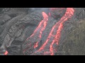
Lava blijt toch groeien in dikte.
twitter:kenhrubin twitterde op zaterdag 08-11-2014 om 06:32:43 #Kilauea lava flow continues to inflate (thicken) - see comparison or power pole base in image http://t.co/XIaBcplyOl http://t.co/yo6hv8OdqE reageer retweet


<a href="http://goo.gl/q8fhTe" target="_blank">FAQ?</a>
<a href="http://goo.gl/gYvZFq" target="_blank">Geel is een zonnige en vrolijke kleur, als hij tenminste enigszins warm is gekleurd en wat naar het oranje neigt</a>
<a href="http://goo.gl/gYvZFq" target="_blank">Geel is een zonnige en vrolijke kleur, als hij tenminste enigszins warm is gekleurd en wat naar het oranje neigt</a>
twitter:kenhrubin twitterde op zondag 09-11-2014 om 06:43:02 #Kilauea lava overflow of skylight near Puu Oo surrounded/trapped tripod of USGS monitoring camera, Nov. 7, HVO image http://t.co/IjtVSNDuyH reageer retweet

<a href="http://goo.gl/q8fhTe" target="_blank">FAQ?</a>
<a href="http://goo.gl/gYvZFq" target="_blank">Geel is een zonnige en vrolijke kleur, als hij tenminste enigszins warm is gekleurd en wat naar het oranje neigt</a>
<a href="http://goo.gl/gYvZFq" target="_blank">Geel is een zonnige en vrolijke kleur, als hij tenminste enigszins warm is gekleurd en wat naar het oranje neigt</a>
Argg, aanpassingen lopen weer fout......
<a href="http://goo.gl/q8fhTe" target="_blank">FAQ?</a>
<a href="http://goo.gl/gYvZFq" target="_blank">Geel is een zonnige en vrolijke kleur, als hij tenminste enigszins warm is gekleurd en wat naar het oranje neigt</a>
<a href="http://goo.gl/gYvZFq" target="_blank">Geel is een zonnige en vrolijke kleur, als hij tenminste enigszins warm is gekleurd en wat naar het oranje neigt</a>
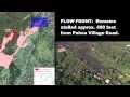
1e huis is er aan.quote:NEWS BRIEFS
The flow front remains stalled 480 feet from the Pahoa Village Road with very little activity and has not advanced.
A lava breakout in the area of Apa’a Street near the cemetery has entered a private property and is only 5 yards away from the garage area of a residential structure. Civil defense says it is possible that these buildings may be affected by the advancing flow later today.
twitter:eruptionsblog twitterde op dinsdag 11-11-2014 om 02:35:06 The Pahoa lava flow on Kilauea has taken its first house: http://t.co/PDk1LrXLb7 reageer retweet


<a href="http://goo.gl/q8fhTe" target="_blank">FAQ?</a>
<a href="http://goo.gl/gYvZFq" target="_blank">Geel is een zonnige en vrolijke kleur, als hij tenminste enigszins warm is gekleurd en wat naar het oranje neigt</a>
<a href="http://goo.gl/gYvZFq" target="_blank">Geel is een zonnige en vrolijke kleur, als hij tenminste enigszins warm is gekleurd en wat naar het oranje neigt</a>
Meer nieuws
[ Bericht 52% gewijzigd door bwt op 12-11-2014 12:21:56 ]

twitter:janinekrippner twitterde op woensdag 12-11-2014 om 11:54:59 Hawaii lava flow: Flow front stalled, breakouts monitored. Image: lava interacts with water http://t.co/0y4Z0CToSy http://t.co/QSCwREgJnB reageer retweet
 Hawaii lava flow: Flow front stalled, breakouts monitored. Image: lava interacts with water
[ Bericht 52% gewijzigd door bwt op 12-11-2014 12:21:56 ]
<a href="http://goo.gl/q8fhTe" target="_blank">FAQ?</a>
<a href="http://goo.gl/gYvZFq" target="_blank">Geel is een zonnige en vrolijke kleur, als hij tenminste enigszins warm is gekleurd en wat naar het oranje neigt</a>
<a href="http://goo.gl/gYvZFq" target="_blank">Geel is een zonnige en vrolijke kleur, als hij tenminste enigszins warm is gekleurd en wat naar het oranje neigt</a>
Waar ligt de lava en de uitbraken.
(klik voor de grote versie)
(klik voor de grote versie)

<a href="http://goo.gl/q8fhTe" target="_blank">FAQ?</a>
<a href="http://goo.gl/gYvZFq" target="_blank">Geel is een zonnige en vrolijke kleur, als hij tenminste enigszins warm is gekleurd en wat naar het oranje neigt</a>
<a href="http://goo.gl/gYvZFq" target="_blank">Geel is een zonnige en vrolijke kleur, als hij tenminste enigszins warm is gekleurd en wat naar het oranje neigt</a>

[ Bericht 100% gewijzigd door bwt op 17-11-2014 09:33:34 ]
<a href="http://goo.gl/q8fhTe" target="_blank">FAQ?</a>
<a href="http://goo.gl/gYvZFq" target="_blank">Geel is een zonnige en vrolijke kleur, als hij tenminste enigszins warm is gekleurd en wat naar het oranje neigt</a>
<a href="http://goo.gl/gYvZFq" target="_blank">Geel is een zonnige en vrolijke kleur, als hij tenminste enigszins warm is gekleurd en wat naar het oranje neigt</a>
Er is ergens een Kilaluea (of hoe het ding ff heet  ) topic...
misschien kunnen we dat weer eens pimpen?
misschien kunnen we dat weer eens pimpen?
Is misschien wel een goed idee, een Hawaii topic
Ik heb altijd ruzie met de zoekfunctie van fok. Kan het dus niet vinden.
Ik heb altijd ruzie met de zoekfunctie van fok. Kan het dus niet vinden.
<a href="http://goo.gl/q8fhTe" target="_blank">FAQ?</a>
<a href="http://goo.gl/gYvZFq" target="_blank">Geel is een zonnige en vrolijke kleur, als hij tenminste enigszins warm is gekleurd en wat naar het oranje neigt</a>
<a href="http://goo.gl/gYvZFq" target="_blank">Geel is een zonnige en vrolijke kleur, als hij tenminste enigszins warm is gekleurd en wat naar het oranje neigt</a>
Meanwhile:
----------
Mooie foto - klik voor grote versie
Dat een simpel gaas hekwerk een lava stroom kan tegenhouden.twitter:AGUvgp twitterde op maandag 17-11-2014 om 13:47:57 Chain linked fence actually resists Hawaiian lava flow: https://t.co/KLMakxE0q1 RT@TheEarthStory reageer retweet
 Chain linked fence actually resists Hawaiian lava flow:
 ----------
Mooie foto - klik voor grote versie

<a href="http://goo.gl/q8fhTe" target="_blank">FAQ?</a>
<a href="http://goo.gl/gYvZFq" target="_blank">Geel is een zonnige en vrolijke kleur, als hij tenminste enigszins warm is gekleurd en wat naar het oranje neigt</a>
<a href="http://goo.gl/gYvZFq" target="_blank">Geel is een zonnige en vrolijke kleur, als hij tenminste enigszins warm is gekleurd en wat naar het oranje neigt</a>
quote:NEWS BRIEFS
The flow field in Pahoa has gone quiet. Civil defense reports the nearest surface flow activity and surface breakouts are approximately 6 miles upslope of Apa’a Street, between the Pu’u O’o vent and the crack system.
Lava remains in the system, and so the evacuation advisory for those residents down slope of the flow will continue. Also, Pahoa Village Road between Apa’a Street and the Post Office Road will remain closed and limited to area residents only.
[ Bericht 100% gewijzigd door bwt op 18-11-2014 13:10:33 ]
<a href="http://goo.gl/q8fhTe" target="_blank">FAQ?</a>
<a href="http://goo.gl/gYvZFq" target="_blank">Geel is een zonnige en vrolijke kleur, als hij tenminste enigszins warm is gekleurd en wat naar het oranje neigt</a>
<a href="http://goo.gl/gYvZFq" target="_blank">Geel is een zonnige en vrolijke kleur, als hij tenminste enigszins warm is gekleurd en wat naar het oranje neigt</a>
twitter:janinekrippner twitterde op dinsdag 18-11-2014 om 11:56:28 Hawaii lava flow update: breakouts 6 miles upslope from Apaʻa St disrupt lava supply http://t.co/yRcg671Fa3 http://t.co/5nEHBhlQbr reageer retweet
twitter:CPPGeophysics twitterde op dinsdag 18-11-2014 om 16:39:05 Good news for Puna residents: HVO scientists note "marked decrease in the surface breakouts" during overflight http://t.co/YjRXINr4KH reageer retweet
 Good news for Puna residents: HVO scientists note "marked decrease in the surface breakouts" during overflight
 [ Bericht 27% gewijzigd door bwt op 18-11-2014 16:57:27 ]
<a href="http://goo.gl/q8fhTe" target="_blank">FAQ?</a>
<a href="http://goo.gl/gYvZFq" target="_blank">Geel is een zonnige en vrolijke kleur, als hij tenminste enigszins warm is gekleurd en wat naar het oranje neigt</a>
<a href="http://goo.gl/gYvZFq" target="_blank">Geel is een zonnige en vrolijke kleur, als hij tenminste enigszins warm is gekleurd en wat naar het oranje neigt</a>

quote:NEWS BRIEFS
• No activity was observed downslope of the crack system, although “numerous surface breakouts and flows were noted in the areas from the vent to the crack system indicating lava remains in the system” reports civil defense. The nearest surface activity is 5 miles upslope of Apa’a Street.
• Scientists believe the decrease in flow front activity is the result of a lava supply disruption following a large breakout at Puʻu Kahaualeʻa near Puʻu ʻŌʻō, which began overnight on November 14–15.
• Emergency officials have not called it a day. The evacuation advisory for Pahoa residents down slope of the flow will continue. Also, Pahoa Village Road between Apa’a Street and the Post Office Road will remain closed and limited to area residents only.
[ Bericht 9% gewijzigd door bwt op 19-11-2014 16:33:39 ]
<a href="http://goo.gl/q8fhTe" target="_blank">FAQ?</a>
<a href="http://goo.gl/gYvZFq" target="_blank">Geel is een zonnige en vrolijke kleur, als hij tenminste enigszins warm is gekleurd en wat naar het oranje neigt</a>
<a href="http://goo.gl/gYvZFq" target="_blank">Geel is een zonnige en vrolijke kleur, als hij tenminste enigszins warm is gekleurd en wat naar het oranje neigt</a>
twitter:kenhrubin twitterde op vrijdag 21-11-2014 om 10:04:24 #Kilauea lava flow front remains inactive but breakouts are occurring upslope 1.9km W of Kaohe Homesteads (HVO photo) http://t.co/gk1j8PQ46N reageer retweet

<a href="http://goo.gl/q8fhTe" target="_blank">FAQ?</a>
<a href="http://goo.gl/gYvZFq" target="_blank">Geel is een zonnige en vrolijke kleur, als hij tenminste enigszins warm is gekleurd en wat naar het oranje neigt</a>
<a href="http://goo.gl/gYvZFq" target="_blank">Geel is een zonnige en vrolijke kleur, als hij tenminste enigszins warm is gekleurd en wat naar het oranje neigt</a>
vulkaanuitbarsting op de Kaapverdische Eilanden

quote:Rare eruption of Pico do Fogo
A rare eruption of Cape Verde volcano Pico do Fogo, its biggest in decades, caused the closure of the airport and evacuation of local residents, officials told state radio on Sunday.
No damage or injuries were reported following Saturday's 8:00 pm (2100 GMT) blast but villagers at the bottom of the volcano on the Atlantic island nation were being evacuated over the weekend and a further eruption was reported on Sunday.
There were no immediate details on the intensity of the Sunday blast.
Vulcanologist Bruno Faria told state-owned Radio Cape Verde the first blast was "much greater than the one in 1995" which showered a cloud of ash across the island at the southern tip of the archipelago.
"The eruption was very fast. But we are appealing to the people for calm," interior minister Marise Morais told the radio in an announcement heard by AFP in Guinea-Bissau.
The eruption reached level three on the nine-level volcanic explosivity index, the minister said.
Morais said the nation was implementing its emergency civil protection plan.
Nelio Santos, a television journalist reached by telephone, told AFP authorities had begun evacuating Cha das Caldeiras, a village of around 750 inhabitants at the foot of the volcano.
"Many people... left without waiting for the instructions from the authorities," he added.
The airport on Fogo was closed Sunday, although it was not immediately clear how many flights had been diverted or cancelled.
The privately-owned, US-based Volcano Discovery website, which tracks volcanic activity worldwide, said a new eruption started Sunday at 10:00 am, with satellite data suggesting some lava at the vent.
Pico de Fogo last erupted on April 2 1995 -- for the first time since June 1951 -- and almost 5,000 people were evacuated while the United States and several European countries sent assistance.
The archipelago, which lies 500 kilometres (about 300 miles) off the coast of Senegal, consists of 10 islands, eight of which are inhabited and volcanic.


Het dorp gaat er aan
twitter:VolcanoReport twitterde op donderdag 27-11-2014 om 18:10:12 Fogo volcano, Cabo verde - Portelo village is currently being destroyed - LIVESTREAM link - http://t.co/4AugXjIVLC http://t.co/zciLyHoTOf reageer retweet

<a href="http://goo.gl/q8fhTe" target="_blank">FAQ?</a>
<a href="http://goo.gl/gYvZFq" target="_blank">Geel is een zonnige en vrolijke kleur, als hij tenminste enigszins warm is gekleurd en wat naar het oranje neigt</a>
<a href="http://goo.gl/gYvZFq" target="_blank">Geel is een zonnige en vrolijke kleur, als hij tenminste enigszins warm is gekleurd en wat naar het oranje neigt</a>