WKN Weer, Klimaat en Natuurrampen
Lees alles over het onstuimige weer op onze planeet, volg orkanen en tornado's, zie hoe vulkanen uitbarsten en hoe Moeder Aarde beeft bij een aardbeving. Alles over de verwoestende kracht van onze planeet en tal van andere natuurverschijnselen.


---------------------------------------------------------------------------------------------------------------------------------
 Alles over ORKAAN IKE in dit topic: Orkaan Ike op weg naar Texas
---------------------------------------------------------------------------------------------------------------------------------
Hier is dan het tweede deel voor Hurricane Season 2008 voor zowel Atlantische, Indische als Pacifische stormen.
Algemene Info
Met de term 'Hurricane Season' bedoelden we in eerste instante de periode van 1 juni tot 30 november.
Deze periode wordt in het Atlantische basin en de Golf van Mexico gezien als het Stormen-seizoen. Echter komen deze geweldadige stormen overal in de wereld voor en met name in Azië zorgen ze jaarlijks voor duizenden slachtoffers en tienduizenden daklozen. Echter horen we vaak erg weinig over de stormen in Azië en juist meer over die in de VS.
In de laatste jaren zijn Tropische Stormen meer en meer in de media gekomen. Het lijkt ook alsof ze meer en meer slachtoffers maken. Een documentaire over Hurricane Andrew uit 1992, heeft diepe indruk gemaakt en ook zullen kenners orkanen Floyd, Gilbert, Stan en Ivan zich zeker nog herinneren. De catastrofe die "Katrina" met zich meebracht ging de hele wereld over. En dan praten we eigenlijk alleen over de Atlantische stormen en lijken we te vergeten dat er vorig jaar 4000 doden vielen in Bangladesh door orkaan Sidr.
Hoewel het Atlantische seizoen pas officieel in juni begint zijn er op andere plekken in de wereld zeker meer orkanen te vinden in de komende maanden. We zullen ook deze dus zeker gaan bespreken. Waarschijnlijk zal de kern van de discussie en de posts gaan over de periode 1-6-2008 t/m 30-11-2008. T.z.t. zal er ook wel een NWS-topic worden geopend als een orkaan ook uitgebreid in het nieuws komt.
Orkanen: Hoe ontstaan ze eigenlijk?
op de site van Wikipedia kan je in het Nederlands nalezen hoe ze ontstaan en wat de belangrijkste energiebron is voor hun verwoestende kracht: het warme zeewater http://nl.wikipedia.org/wiki/Orkaan#Ontstaan
Ook de BBC heeft er een interessante en leuke animatie over gemaakt. Ook wordt er op LiveScience in het engels prima uitgelegd hoe ze ontstaan en zich ontwikkelen
Indeling en Kracht
De stormen worden ingedeeld op 'categorie'. Vaak zijn het eerst tropische stormen" (Tropical Depression, Tropical Storms), die overgaan op Orkaanstatus (Hurricane/Tyfoons) Ze worden ingedeeld op windsnelheden via de Saffir-Simpson Schaal
Tropical Depression 24-38 mph winds (38-61 km/u)
Tropical Storm 39-73 mph winds (62-118 km/u)
Hurricane Categorie 1 74-95 mph winds (119-153 km/u) -- 4/5 ft Storm Surge -- Vb. Danny 1997, Stan 2005
Hurricane Categorie 2 96-110 mph winds (154-177 km/u) - 6/8 ft Storm Surge -- Vb. Danielle 2004
Hurricane Categorie 3 111-130 mph winds (178-209 km/u) - 9/12 ft Storm Surge - Vb.Fran 1996, Beta 2005
Hurricane Categorie 4 131-155 mph winds (210-249 km/u) - 13/18 ft Storm Surge - Vb.Hugo 1989, Frances 2004
Hurricane Categorie 5 > 156 mph winds (meer dan 250 km/u) -- 18ft or more S.S. -- Vb.Andrew 1992, Mitch 1998 en Wilma, Katrina 2005
Namen
De stormen, die vaak gevormd worden op de atlantische oceaan en dan richting de Caribbean of de Oostkust van de VS gaan, krijgen de naam op Alfabetische volgorde. Voor het seizoen 2005 zijn de namen als volgt:
Atlantische Stormen 2008
Arthur, Bertha, Cristobal, Dolly, Edouard, Fay, Gustav, Hanna, Ike, Josephine, Kyle, Laura, Marco, Nana, Omar, Paloma, Rene, Sally, Teddy, Vicky, Wilfred
In het oosten van de pacific ontstaan ook Hurricanes, ook wel Cylonen en/of Tyfoons genoemd. Deze zorgen vaak voor weinig schade aan de Amerikaanse westkust.
Oost Pacifische Stormen 2008
Alma, Boris, Cristina, Douglas, Elida, Fausto, Genevieve, Hernan, Iselle, Julio, Karina, Lowell, Marie, Norbert, Odile, Polo, Rachel, Simon, Trudy, Vance, Winnie, Xavier, Yolanda, Zeke
Verder zijn er dan nog de stormen in het Noorden, Zuiden en Westen van de Pacific. Met name de stormen in het Noord/Westen komen vaak in het nieuws omdat ze Japan, de Filipijnen, Taiwan en China vaak teisteren, maar ook geheel Zuid Oost Azie kunnen treffen. Meer informatie en de namen van deze stormen zijn hier terug te vinden.
Wanneer zijn die seizoenen nou precies?
ATLANTIC: 1 juni t/m 30 november
NORTH EAST PACIFIC Begin mei t/m begin November, met piek in Augustus/September
NORTH WEST PACIFIC Begin juli t/m eind November, maar eigenlijk hele jaar door aktiviteit.
NORTH INDIAN April t/m December met pieken in Mei en November
SOUTH INDIAN + WEST AUSTRALIAN Oktober t/m Mei met pieken in Februari en April
SOUTH WEST PACIFIC + EAST AUSTRALIANOktober tot eind April met piek in Februari.
Over het algemeen is Mei de rustigste maand en September de zwaarste.
Hoe ziet de voorspelling voor 2008 eruit
Volgens Phil Klotzbach en William Gray van CSU wordt 2008 een gemiddeld orkaanseizoen. Volgens hun ontstaan er 13 stormen die een naam krijgen, waarvan er 3 orkanen worden van categorie 3 of hoger. Ze verwachten een seizoen, redelijk gelijk aan de stormen van 2007. De voorspelling werd op 8 december 2007 gedaan.
Meer hierover kan je hier lezen.
Oude Delen
2004 - Deel 1 en Deel 2
2005 - Deel 1 en Deel 2
2006 - Deel 1 en Deel 2
2007 - Deel 1, Deel 2, Deel 3 en Deel 4
2008 - Deel 1
Enkele Links
1. National Hurricane Centre
2. Carribean Storm Network
3. Hurricanezone
4. Hurricane Track
5. Website met satelietbeelden van de Caribbean en de rest van Amerika
6. Intellicast: Geavanceerde satellietfoto's en gifs van aktuele stormen
7. Tropical Weather Underground
8. Tropical Storm Risico's van dit moment
9. Wikipedia Hurricanes/Tyfonen in het algemeen
10. Alle stormen ter wereld van de laatste jaren in overzicht
11. The StormTrack
12. Orkanensite in de Filipijnen
13. Atlantische Orkanensite
Opmerkelijke Links
Hurricane Season Special Edition Pagina van CNN van 2006
-- Hurricane Katrina CNN Special Report of the Killer Hurricane
-- Hurricane Katrina via WikiPedia
-- Hurricane Season 2005 -- Special van CNN
-- Hurricane Season 2004 -- Special van CNN
-- Overzicht van Atlantische Stormen uit 2005
-- Spectaculaire Satelietshots van stormen
--Animatie van de alle Atlantische Stormen uit 2004
Actuele Radar in Golf van Mexico
Water temperatuur.
=====================
Post hier je gegevens, berichten, data en opmerkelijke zaken over Orkanen, Tyfoons en Hurricanes en van 2008.
[ Bericht 2% gewijzigd door Frutsel op 11-09-2008 10:04:50 ]
Alles over ORKAAN IKE in dit topic: Orkaan Ike op weg naar Texas ---------------------------------------------------------------------------------------------------------------------------------


Hier is dan het tweede deel voor Hurricane Season 2008 voor zowel Atlantische, Indische als Pacifische stormen.
Algemene Info
Met de term 'Hurricane Season' bedoelden we in eerste instante de periode van 1 juni tot 30 november.
Deze periode wordt in het Atlantische basin en de Golf van Mexico gezien als het Stormen-seizoen. Echter komen deze geweldadige stormen overal in de wereld voor en met name in Azië zorgen ze jaarlijks voor duizenden slachtoffers en tienduizenden daklozen. Echter horen we vaak erg weinig over de stormen in Azië en juist meer over die in de VS.
In de laatste jaren zijn Tropische Stormen meer en meer in de media gekomen. Het lijkt ook alsof ze meer en meer slachtoffers maken. Een documentaire over Hurricane Andrew uit 1992, heeft diepe indruk gemaakt en ook zullen kenners orkanen Floyd, Gilbert, Stan en Ivan zich zeker nog herinneren. De catastrofe die "Katrina" met zich meebracht ging de hele wereld over. En dan praten we eigenlijk alleen over de Atlantische stormen en lijken we te vergeten dat er vorig jaar 4000 doden vielen in Bangladesh door orkaan Sidr.
Hoewel het Atlantische seizoen pas officieel in juni begint zijn er op andere plekken in de wereld zeker meer orkanen te vinden in de komende maanden. We zullen ook deze dus zeker gaan bespreken. Waarschijnlijk zal de kern van de discussie en de posts gaan over de periode 1-6-2008 t/m 30-11-2008. T.z.t. zal er ook wel een NWS-topic worden geopend als een orkaan ook uitgebreid in het nieuws komt.
Orkanen: Hoe ontstaan ze eigenlijk?
op de site van Wikipedia kan je in het Nederlands nalezen hoe ze ontstaan en wat de belangrijkste energiebron is voor hun verwoestende kracht: het warme zeewater http://nl.wikipedia.org/wiki/Orkaan#Ontstaan
Ook de BBC heeft er een interessante en leuke animatie over gemaakt. Ook wordt er op LiveScience in het engels prima uitgelegd hoe ze ontstaan en zich ontwikkelen
Indeling en Kracht
De stormen worden ingedeeld op 'categorie'. Vaak zijn het eerst tropische stormen" (Tropical Depression, Tropical Storms), die overgaan op Orkaanstatus (Hurricane/Tyfoons) Ze worden ingedeeld op windsnelheden via de Saffir-Simpson Schaal
Tropical Depression 24-38 mph winds (38-61 km/u)
Tropical Storm 39-73 mph winds (62-118 km/u)
Hurricane Categorie 1 74-95 mph winds (119-153 km/u) -- 4/5 ft Storm Surge -- Vb. Danny 1997, Stan 2005
Hurricane Categorie 2 96-110 mph winds (154-177 km/u) - 6/8 ft Storm Surge -- Vb. Danielle 2004
Hurricane Categorie 3 111-130 mph winds (178-209 km/u) - 9/12 ft Storm Surge - Vb.Fran 1996, Beta 2005
Hurricane Categorie 4 131-155 mph winds (210-249 km/u) - 13/18 ft Storm Surge - Vb.Hugo 1989, Frances 2004
Hurricane Categorie 5 > 156 mph winds (meer dan 250 km/u) -- 18ft or more S.S. -- Vb.Andrew 1992, Mitch 1998 en Wilma, Katrina 2005
Namen
De stormen, die vaak gevormd worden op de atlantische oceaan en dan richting de Caribbean of de Oostkust van de VS gaan, krijgen de naam op Alfabetische volgorde. Voor het seizoen 2005 zijn de namen als volgt:
Atlantische Stormen 2008
Arthur, Bertha, Cristobal, Dolly, Edouard, Fay, Gustav, Hanna, Ike, Josephine, Kyle, Laura, Marco, Nana, Omar, Paloma, Rene, Sally, Teddy, Vicky, Wilfred
In het oosten van de pacific ontstaan ook Hurricanes, ook wel Cylonen en/of Tyfoons genoemd. Deze zorgen vaak voor weinig schade aan de Amerikaanse westkust.
Oost Pacifische Stormen 2008
Alma, Boris, Cristina, Douglas, Elida, Fausto, Genevieve, Hernan, Iselle, Julio, Karina, Lowell, Marie, Norbert, Odile, Polo, Rachel, Simon, Trudy, Vance, Winnie, Xavier, Yolanda, Zeke
Verder zijn er dan nog de stormen in het Noorden, Zuiden en Westen van de Pacific. Met name de stormen in het Noord/Westen komen vaak in het nieuws omdat ze Japan, de Filipijnen, Taiwan en China vaak teisteren, maar ook geheel Zuid Oost Azie kunnen treffen. Meer informatie en de namen van deze stormen zijn hier terug te vinden.
Wanneer zijn die seizoenen nou precies?
ATLANTIC: 1 juni t/m 30 november
NORTH EAST PACIFIC Begin mei t/m begin November, met piek in Augustus/September
NORTH WEST PACIFIC Begin juli t/m eind November, maar eigenlijk hele jaar door aktiviteit.
NORTH INDIAN April t/m December met pieken in Mei en November
SOUTH INDIAN + WEST AUSTRALIAN Oktober t/m Mei met pieken in Februari en April
SOUTH WEST PACIFIC + EAST AUSTRALIANOktober tot eind April met piek in Februari.
Over het algemeen is Mei de rustigste maand en September de zwaarste.
Hoe ziet de voorspelling voor 2008 eruit
Volgens Phil Klotzbach en William Gray van CSU wordt 2008 een gemiddeld orkaanseizoen. Volgens hun ontstaan er 13 stormen die een naam krijgen, waarvan er 3 orkanen worden van categorie 3 of hoger. Ze verwachten een seizoen, redelijk gelijk aan de stormen van 2007. De voorspelling werd op 8 december 2007 gedaan.
Meer hierover kan je hier lezen.
Oude Delen
2004 - Deel 1 en Deel 2
2005 - Deel 1 en Deel 2
2006 - Deel 1 en Deel 2
2007 - Deel 1, Deel 2, Deel 3 en Deel 4
2008 - Deel 1
Enkele Links
1. National Hurricane Centre
2. Carribean Storm Network
3. Hurricanezone
4. Hurricane Track
5. Website met satelietbeelden van de Caribbean en de rest van Amerika
6. Intellicast: Geavanceerde satellietfoto's en gifs van aktuele stormen
7. Tropical Weather Underground
8. Tropical Storm Risico's van dit moment
9. Wikipedia Hurricanes/Tyfonen in het algemeen
10. Alle stormen ter wereld van de laatste jaren in overzicht
11. The StormTrack
12. Orkanensite in de Filipijnen
13. Atlantische Orkanensite
Opmerkelijke Links
Hurricane Season Special Edition Pagina van CNN van 2006
-- Hurricane Katrina CNN Special Report of the Killer Hurricane
-- Hurricane Katrina via WikiPedia
-- Hurricane Season 2005 -- Special van CNN
-- Hurricane Season 2004 -- Special van CNN
-- Overzicht van Atlantische Stormen uit 2005
-- Spectaculaire Satelietshots van stormen
--Animatie van de alle Atlantische Stormen uit 2004
Actuele Radar in Golf van Mexico

Water temperatuur.
=====================
Post hier je gegevens, berichten, data en opmerkelijke zaken over Orkanen, Tyfoons en Hurricanes en van 2008.
[ Bericht 2% gewijzigd door Frutsel op 11-09-2008 10:04:50 ]
Van deze OP werken de links jammer genoeg niet, dus die moet je nog ever overnemen. 
Het zou wat zijn als New Orleans weer ontruimd moet worden.
Maar heel boel bewoners zullen misschien nog geen eens terug zijn.
[ Bericht 0% gewijzigd door sander89 op 06-09-2008 19:15:32 ]
Het zou wat zijn als New Orleans weer ontruimd moet worden.
Maar heel boel bewoners zullen misschien nog geen eens terug zijn.
[ Bericht 0% gewijzigd door sander89 op 06-09-2008 19:15:32 ]
............................
Deze had ik eigenlijk moeten openen, maar ik had het idee dat iemand een betere OP kon doen dan ikzelf.
Life is Music
kegel is nog erg breed natuurlijk. van yucatan tot florida.
over cuba zwakt hij wel af. wat voor cuba zelf natuurlijk niet prettig is.
Dostojewski: "Je kunt je niet van je eigen gezond verstand overtuigen door je buurman op te sluiten."

Nope, Ike gaat separaat verder.quote:Op zaterdag 6 september 2008 21:05 schreef thijsdetweede het volgende:
Mooi! Misschien nog even een link naar deel 1 van dit jaar erbij?

Ehhmmm....quote:Op zaterdag 6 september 2008 22:47 schreef ItaloDancer het volgende:
Dit wordt Ike, ik maak later nog een nieuw deel 2 aan van HS.
Ja dus.
Nou ja, om maar even on topic te blijven (en dus geen Ike verhalen): Hanna kan de US Open tennis op haar conto bijschrijven. De heren finale is maandag, omdat de halve finale niet gespeeld kan worden.
Nou ja, om maar even on topic te blijven (en dus geen Ike verhalen): Hanna kan de US Open tennis op haar conto bijschrijven. De heren finale is maandag, omdat de halve finale niet gespeeld kan worden.

Is het dan niet handig om de TT niet naar de belhamel te laten verwijzen?quote:Op zaterdag 6 september 2008 22:56 schreef ItaloDancer het volgende:
Het is alleen lastiger om de mensen hier weer weg te krijgen mjah

Even een tvp-tje, interessant topic dit....
Unlike those who hide the truth, i tell it like it is......
quote:Op zaterdag 6 september 2008 23:41 schreef ItaloDancer het volgende:
Tropische depressie/storm/depressie Josephine is overigens overleden vandaag
Life is Music
MYRTLE BEACH, South Carolina (CNN) -- After earning a reputation as a killer in Haiti, Tropical Storm Hanna amounted to little more than a windy rainstorm along the Atlantic Coast on Saturday.
No states have "expressed any damage that they couldn't handle," said Glenn Cannon, the Federal Emergency Management Agency's assistant administrator for disaster operations.
He said there were some concerns about flooding near rivers and in low-lying areas.
"We're monitoring Hanna, but it seems to be a heavy rain event," he said.
According to the Associated Press, Hanna did cause one death in a traffic accident on Interstate 95 in Maryland.
Many people in Huntington, Virginia, about 8 miles northwest of Virginia Beach, voluntarily evacuated Saturday afternoon because of concerns about flooding, Fairfax County public information officer Merni Fitzgerald said. The area, which has flooded in the past, was receiving heavy rain, she said.
She could not provide an exact number of people who had evacuated.
The storm drenched the Carolinas and Virginia with heavy rain pushed by 55-mph winds as it zipped northward near 30 mph (48 kph), the National Hurricane Center reported at 11 p.m. ET Saturday.
At that hour, the center of the storm was 90 miles (145 kilometers) west-southwest of Long Island, New York, and about 135 miles (220 kilometers) southwest of Providence, Rhode Island. Hanna would travel the coast all the way up to Canada's Maritime Provinces by Sunday night, forecasters said.
Hanna came ashore at 3:20 a.m. ET near the North Carolina-South Carolina state line.
It caused a surge of 1 to 2 feet of water along the shore and was expected to deliver 4 to 6 inches of rain, with some areas getting more.
Nou niet helemaal waar.quote:Op zaterdag 6 september 2008 23:41 schreef ItaloDancer het volgende:
Tropische depressie/storm/depressie Josephine is overigens overleden vandaag

Ze ligt op de intensive care.
Josephine komt misschien nog wel terug, of krijgt ze dan een andere naam?
http://euler.atmos.colost(...)tic/track_early2.png
http://euler.atmos.colost(...)intensity_early2.png
http://euler.atmos.colost(...)tic/track_early2.png
http://euler.atmos.colost(...)intensity_early2.png
Dostojewski: "Je kunt je niet van je eigen gezond verstand overtuigen door je buurman op te sluiten."

Nee, ze blijft dezelfde naam houden.quote:Op zondag 7 september 2008 19:16 schreef Caesu het volgende:
Josephine komt misschien nog wel terug, of krijgt ze dan een andere naam?
http://euler.atmos.colost(...)tic/track_early2.png
http://euler.atmos.colost(...)intensity_early2.png
Is wel vaker gebeurd trouwens dat een systeem degradeerd tot depressie, maar later weer uitgroeid tot een orkaan.
Maar het was niet eens meer een "tropische depressie", enkel nog een 'simpel' lagedrukgebied.quote:Op zondag 7 september 2008 21:37 schreef aloa het volgende:
[..]
Nee, ze blijft dezelfde naam houden.
Is wel vaker gebeurd trouwens dat een systeem degradeerd tot depressie, maar later weer uitgroeid tot een orkaan.
quote:Op zondag 7 september 2008 22:20 schreef Fredo55 het volgende:
Wie verzint die namen eigenlijk?
quote:De Australische meteoroloog Clement Wragge gebruikte aan het eind van de 19e eeuw als eerste meisjesnamen voor tropische stormen. In de Tweede Wereldoorlog werd dat gebruik van meisjesnamen in alfabetische volgorde de normale praktijk in het Caraïbische gebied. Elke tropische depressie met ten minste windkracht 8 krijgt een eigen naam. In 1978 deden, na protest uit het feministische kamp, voor het eerst jongensnamen hun intrede, aanvankelijk alleen in het gebied van de Stille Oceaan voor de Amerikaanse westkust, een jaar later ook op de Atlantische Oceaan en in de Golf van Mexico.
Voor de Atlantische stormen heeft de Wereld Meteorologische Organisatie zes namenlijsten van telkens 21 namen opgesteld; om de zes jaar komen dezelfde namen dus weer terug. Het is een alfabetische lijst met alternerend een vrouwelijk en een mannelijke naam. De letters Q, U, X, Y en Z worden niet gebruikt omdat er te weinig namen zijn.
De naam van verwoestende orkanen die weergeschiedenis hebben geschreven en die men zich nog generaties lang kan heugen wordt van de lijst afgevoerd en vervangen door een nieuwe. Sinds 1954 is dat 67 keer gebeurd. De meest recente voorbeelden zijn Dennis, Katrina, Rita, Stan en Wilma uit 2005, Charley, Frances, Ivan en Jeanne uit 2004, Fabian, Isabel en Juan uit 2003 en Isodore en Lili uit 2002. Om politieke redenen is ook de naam Adolph geschrapt.
Via de webcams bij weeronline.nl kan je mooi de naderende orkaan zien bij Key West...
The black and white you'll never pass, stick yer blue flag up yer arse!
'They know on the Continent that European football without the English is like a hot dog without the mustard' Sir Bobby Charlton
'They know on the Continent that European football without the English is like a hot dog without the mustard' Sir Bobby Charlton
Volgens mij zou een duidelijk overblijfsel van Josephine altijd Josephine blijven heten. Zo had achteraf gezien Katrina eigenlijk tropische depressie 12 moeten zijn (zo uit mijn hoofd) en niet 15 oid. Pas als Jo zou samenvoegen met een ander systeem, en daar komt dan weer een TD uit voort, wordt de nummering en naamgeving gewijzigd.quote:Op zondag 7 september 2008 22:49 schreef ItaloDancer het volgende:
[..]
Maar het was niet eens meer een "tropische depressie", enkel nog een 'simpel' lagedrukgebied.
Iets dergelijks geldt dacht ik ook voor crossover storms: Stormen die bv op de atlantische oceaan ontstaan, over midden amerika trekken en doodleuk een pacific storm worden.
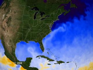
Status op dit moment:quote:Op dinsdag 9 september 2008 16:26 schreef Frutsel het volgende:
Orkaan Sinlaku in de Pacific
[ afbeelding ]
Tropical Storm "MARCE" has intensified further.
Location of Center:
(as of 4:00 p.m.) 340 kms East Southeast of Casiguran, Aurora
Coordinates: 18.0°N, 125.0°E
Strength: Maximum sustained winds of 95 kph near the center and gustiness of 120 kph
Movement: Northwest at 11 kph
Forecast Positions/Outlook: Wednesday afternoon:
200 kms Northeast of Aparri, Cagayan
Thursday afternoon:
400 kms North Northeast of Aparri, Cagayan or
200 kms North Northeast of Basco, Batanes
Friday afternoon:
460 kms East Northeast of Basco, Batanes
Ik ben een eckte rapnegert
Sinlaku 10 september. Snel aan het intensiveren.
Name: Typhoon SINLAKU (15W)
Date: 09-10-08
Updated: 6:08 AM (22:08 GMT)
1-min.Winds
Warning Date/Time (in Knots) Direction of
Number (in UTC) Lat Lon Sust Gust Movement (Kts) Status Remarks
-------------------------------------------------------------------------------------------
... 08/0000Z 16.0N 126.8E 18 23 W 06 TropDis TCFA
001 08/1200Z 16.4N 125.8E 30 40 NW 06 TropDep Initial Warning
002 08/1800Z 16.7N 125.6E 40 50 NW 04 TropStm Upgraded
003 09/0000Z 17.1N 125.3E 50 65 NW 05 TropStm Intensified
004 09/0600Z 17.8N 125.2E 60 75 N 07 TropStm Near Typhoon
005 09/1200Z 18.6N 125.2E 65 80 N 06 Typhoon Upgraded/Cat 1
006 09/1800Z 19.3N 124.7E 90 110 NNW 07 Typhoon Intnsfd/Cat 2
Dus binnen 1 dag van depressie naar Cat 2 typhoon
Ik ben een eckte rapnegert
Momenteel (alweer) de Batanes-eilanden (tussen Filippijnen en Taiwan)
Helaas is dat zo'n beetje standaard. Ik snap niet dat die bewoners daar niet gillend gek worden.
Status (text)
Typhoon SINLAKU (MARCE) is currently undergoing rapid intensification over the warm Philippine Sea...may reach 200 km/hr. Heavy Squalls from its outer bands continues to affect Batanes and Northern Luzon.
*Residents along Okinawa, Ryukyu Island Chain & the Southern Coast of Kyushu in Japan should closely monitor the progress of SINLAKU.

Ik ben een eckte rapnegert
En we zitten inmiddels op Categorie 3!
Intensiveert snel. Momenteel 205km per uur aan windsnelheid. Verwachting is dat Sinlaku vrijdag Cat. 4 bereikt.
Daarnaast, ten zuiden van Japan nóg een storm ontstaan, momenteel nog naamloos
Intensiveert snel. Momenteel 205km per uur aan windsnelheid. Verwachting is dat Sinlaku vrijdag Cat. 4 bereikt.

Daarnaast, ten zuiden van Japan nóg een storm ontstaan, momenteel nog naamloos

Ik ben een eckte rapnegert
't is pas donderdag en nu is Sinlaku al uitgegroeid tot Cat.4. Er bestaat een goede kans dat ie uitgroeid tot een Supertyphoon. Sinlaku haalt nu slnelheden van 240 km/h en zal hiermee haar koers vervolgen richting japan.
+ Forecast Outlook: SINLAKU is expected to resume its slow Northerly to NNW track, bringing the dangerous storm over Yaeyama Island Chain and much closer to the east coast of Taiwan tomorrow night or early Saturday morning. SINLAKU is likely to reach Super Typhoon strength w/ winds of 240 kph later this afternoon or tonight. The 3 to 5-day long-range forecast shows SINLAKU recurving NNE to NE-ward beginning Sunday or Monday towards the direction of SW Japan. *Alternate Forecast Scenario: Some computer models are showing a possibilty that SINLAKU may track northwestward and make landfall over NE Taiwan tomorrow or Saturday - instead of moving North or NNE. This scenario is likely if the strong steering ridge to its east extends to its north.
+ Effects: SINLAKU's strong circulation continues to swirl counter-clockwise over the Northern Philippine Sea with its outer bands still affecting the Batanes Group of Islands...spreading further across Yaeyama Island Chain and the East Coast of Taiwan. Cloudy skies w/ at times moderate to heavy squalls with winds not exceeding 60 km/hr can be expected along these bands. Residents in low-lying areas & steep slopes must seek evacuation for possible life-threatening flash floods & landslides due to the anticipated heavy rains brought about by this system. Precautionary measures must be initiated if necessary. Possible coastal Storm Surge flooding of 13 to 18 feet above normal tide levels...along with large and dangerous battering waves can be expected near and to the north of SINLAKU's projected path. Extreme damage is possible on this type of storm surge.
Ik ben een eckte rapnegert
SINLAKU's strong circulation continues to swirl counter-clockwise over the Northern Philippine Sea, with a possible Eyewall Replacement Cycle (ERC) going on at this moment.
Mogelijk dat ie dan tijdelijk even in kracht afneemt, waarna hij inderdaad die Cat.5 Supertyphoon gaat worden...
Momenteel is het 948mbar in het oog...
Mogelijk dat ie dan tijdelijk even in kracht afneemt, waarna hij inderdaad die Cat.5 Supertyphoon gaat worden...
Momenteel is het 948mbar in het oog...
Ik ben een eckte rapnegert
Update over Sinlaku:
Taiwan krijgt er dus goed van langs...
+ Forecast Outlook: SINLAKU is expected to continue moving slowly NNW for the next 24 to 36 hours, reintensifying back to a Category 4 typhoon w/ forecast winds of 215 kph tomorrow night. The core shall reach Yaeyama Island Chain, just to the east of Northern Taiwan tomorrow morning. The 3 to 5-day long-range forecast shows SINLAKU starting to recurve gradually to the NE beginning Sunday morning towards Southern Kyushu in Japan. The typhoon is forecast to lose strength down to Category 1 as it approaches the Southern Coast of Kyushu on Wednesday morning, Sep 17.*Alternate Forecast Scenario: Some computer models are still showing a possibilty that SINLAKU may track more northwestward or WNW and make landfall over Northern Taiwan tomorrow. This scenario is likely if the strong steering ridge to its east continues to extend to its north. Actually most of the Asian agencies shows this scenario.
[ Bericht 44% gewijzigd door Gummibeer79 op 12-09-2008 14:14:35 ]
Ik ben een eckte rapnegert
Systeem nog steeds Cat3. maar Taiwan krijgt nu echt de volle laag!
Zie update:
+ Forecast Outlook: SINLAKU's forecast has again changed, now bringing the core near to the Northern Coast of Taiwan tomorrow evening. It is expected to recurve sharply to the NE by tomorrow afternoon, regaining possibly its 215-kph Category 4 winds. The 3 to 5-day long-range forecast shows SINLAKU accelerating in a more ENE track beginning late Sunday evening towards the Southern coast of Kyushu in Japan. The typhoon is forecast to lose its strength, down to Category 1 - as it approaches the Japanese Coast sometime Tuesday evening, Sep 16.*Alternate Forecast Scenario: Some computer models are still showing a possibilty that SINLAKU may track more WNW-ward, making landfall over Northern Taiwan tomorrow. This scenario is likely if the strong steering ridge to its east continues to extend to its north and strengthen.
Ik ben een eckte rapnegert
Ben je mal.... dat is Josephine die nog een keer doet alsof ze dingen kan. Kan ze niet.quote:Op donderdag 11 september 2008 19:35 schreef Co_OL het volgende:
De opvolger van Ike is ook in de maak
[ afbeelding ]
Nieuwe Typhoon in het bassin van de West-Pacific: Hagupit / Nina
Nina zal vanavond of morgenochtend zijn uitgegeroeid tot typhoon klasse 1 en over het schiereiland Luzan trekken.
Actueel:
+ Forecast Outlook: HAGUPIT is expected to track WNW to NW for the 2 days, becoming a Category 1 Typhoon this afternoon or tonight. The 3 to 5-day long-range forecast shows HAGUPIT returning back to its WNW track on Monday morning, passing very close to the Northern tip of Cagayan and across the Calayan and Babuyan Group of Islands on Tuesday Sep 23 w/ projected wind speeds of almost 200 kph (Category 3). It shall then move out into the South China Sea on Wednesday morning, Sep 24. The typhoon shall be approaching the southern coast of Guangdong Province of China, near Hong Kong-Macau area on Thursday Sep 25 as a Category 3 system with projected wind speeds of 195 kph. *Alternate Forecast Scenario: There's a possibilty that HAGUPIT may continue tracking more Westward & make landfall over Central or Northern Luzon on Tuesday, Sep 23. This scenario is likely if the westward extension of the strong steering ridge north & NW of HAGUPIT remains strong.
+ Effects: HAGUPIT's large circulation remains over the Philippine Sea, with the development of a banding eye - which suggest that the system is nearing typhoon status. Its outer bands continues to spread across the eastern coast of Visayas (Samar & Leyte)...expected to reach the Bicol Region later this afternoon. Under these bands, the affected areas will experience light to moderate rainfall w/ winds not exceeding 50 km/hr. Moderate to heavy Squalls associated with the outer bands can be expected later tonight or tomorrow over the affected areas, as HAGUPIT moves closer. People living around the slopes of Mayon Volcano in Albay & of Bulusan Volcano in Sorsogon - especially along the areas where possible MUDFLOWS (LAHAR) FLOWS (mixture of volcanic mud and water) are located must stay alert as moderate to heavy rains associated by this storm are likely to affect the area beginning tomorrow. Residents in low-lying areas & steep slopes must remain alert & seek evacuation for possible life-threatening flash floods & landslides due to the anticipated heavy rains brought about by this system. Precautionary measures must be initiated if necessary.
http://www.typhoon2000.ph/activeflash/stormloop.htm


Ik ben een eckte rapnegert
Niet lang meer denk ik..... deze gaat het redden.quote:Op dinsdag 16 september 2008 13:09 schreef Co_OL het volgende:
[ afbeelding ]
Stilte voor de storm momenteel

zo gaat ie weer over Haïti heen.
Dostojewski: "Je kunt je niet van je eigen gezond verstand overtuigen door je buurman op te sluiten."

quote:Deadly tyfoon hits China
A typhoon that killed eight people in the Philippines smashed into southern China on Wednesday.
Typhoon Hagupit came ashore in southern China's Guangdong province with a top wind speed of 106 miles (172 km) an hour, the state-run Xinhua news agency reported.
More than 200,000 fishermen came to shore in advance of the storm, and roughly 28,000 people on land were evacuated, the agency said.
In the Philippines, the storm killed at least eight people and damaged 839 houses, authorities said Wednesday. At least 15 people were missing, according to a statement from the National Disaster Coordinating Council.
The dead include three people who were killed in a landslide, one who was electrocuted and four who drowned, the council said.
Overall, it said, the storm affected nearly 113,000 people in the Philippines, authorities said

Tropical Storm KYLE
Dostojewski: "Je kunt je niet van je eigen gezond verstand overtuigen door je buurman op te sluiten."
Ook wel eens fijn, een tropische storm die gewoon over zee raast. Al zal hij het weer bij ons wel weer eens flink in de war kunnen schoppen over pakweg een week.
Benieuwd of het orkaanseizoen de komende tijd nog van de grond komt, want na eind augustus met 4 orkanen is het nu opvallend rustig. Het zeewater is meer dan warm genoeg, de bovenluchtomstandigheden zijn alleen erg ongunstig.
Benieuwd of het orkaanseizoen de komende tijd nog van de grond komt, want na eind augustus met 4 orkanen is het nu opvallend rustig. Het zeewater is meer dan warm genoeg, de bovenluchtomstandigheden zijn alleen erg ongunstig.
Het zou kunnen.... enkele van de krachtigste orkanen allertijden (Wilma en Mitch) ontstonden in oktober
SUPER TYPHOON JANGMI [OFEL/19W/0815]quote:Op donderdag 25 september 2008 15:51 schreef Frutsel het volgende:
Taiwan krijgt zondag/maandag te maken met Tyfoon Jangmi
[ afbeelding ]
--------------------------------------------------------------------------------
JANGMI (OFEL) becomes the 2nd Super Typhoon of 2008...now a catastrophic category 5 threat to Taiwan. Outer bands with heavy squalls approaching the east coast of Taiwan and Extreme Northern Luzon.
*Interests along the northern and northeastern coast of Luzon, Batanes-Babuyan-Calayan-Itbayat-Yaeyama Islands, particularly Taiwan should closely monitor the progress of JANGMI (OFEL).
*Kindly refer to your local warnings & bulletins issued by your country's official weather agency. This advisory is intended for additional information purposes only.
+ Forecast Outlook: JANGMI is expected to continue moving northwesterly with a slight WNW bend within the next 24 to 48 hours. Its powerful core (eye and eyewall) shall make landfall along Eastern Taiwan tomorrow evening, passing more or less 200 km to the north of Batanes...and cross Central Taiwan until Monday morning. JANGMI shall traverse the Taiwan Straight before its final landfall along Fujian Province during the early morning hours on Tuesday Sep 30...and dissipate over Fujian, China on Oct 1st.
+ Effects: JANGMI's perfect radial circulation continues to cover the northern part of the Philippine Sea...western outer bands now spreading across the northeastern coast of Northern Luzon including Batanes-Babuyan-Calayan Islands, and Eastern Taiwan. Passing moderate to heavy squalls associated with its outer bands can be expected along the affected areas...while danger of Rip Currents or Rip Tides can be expected along the beach-front areas of Eastern Luzon, Batanes-Calayan-Babuyan Group and Taiwan. Possible coastal Storm Surge flooding of more than 18 feet above normal tide levels...accompanied by large and dangerous battering waves...is possible near the center of JANGMI. Extreme damage is possible on this type of storm surge. Far-fetched storm surge is possible along coastal areas of Eastern Luzon & Eastern Visayas with surf reaching 3 to 5 feet at most.
http://www.typhoon2000.ph/activeflash/stormloop.htm
Ik ben een eckte rapnegert
Super Typhoon JANGMI (OFEL) remains a very dangerous...catastrophic Category 5 "monster"...with a 54-km round EYE...Taiwan facing the worst.
*Interests along Taiwan and Fujian Province of China should closely monitor the progress of JANGMI (OFEL).
*Kindly refer to your local warnings & bulletins issued by your country's official weather agency. This advisory is intended for additional information purposes only.
+ Forecast Outlook: JANGMI shall maintain its northwesterly path for the next 2 days and slightly weaken as it nears Taiwan. Its very powerful core (eye and eyewall) is expected to make landfall along Eastern Taiwan...very close to the south of Hualien City tomorrow evening...a slight northward jog will hit the city directly. The system shall then cross the mountainous terrain of Central Taiwan until Monday morning and then traverse Taiwan Straight before its final landfall along Fujian Province Monday evening Sep 29...passing very close or over Fuzhou City. JANGMI is forecast to weaken to a Tropical Storm - when it moves across Fujian Province on Tuesday and Wednesday.
+ Effects: JANGMI's dangerous and powerful circulation continues to engulf the northern part of the Philippine Sea...western outer bands continues to spreading across the northeastern coast of Northern Luzon including Batanes-Babuyan-Calayan Islands, and Eastern Taiwan. Passing moderate to heavy squalls associated with its outer bands can be expected along the affected areas. The danger from Rip Currents or Rip Tides can be expected along the beach-front areas of Eastern Luzon, Batanes-Calayan-Babuyan Group and Taiwan. Typhoon conditions will begin to commence across Eastern and Central Taiwan beginning tomorrow afternoon. 1-day rainfall accumulations of 200 up to 400 mm is possible along the inner bands...with isolated accumulations of 500 to 600 mm at the eyewall of JANGMI and along mountain slopes of Eastern and Central Taiwan. Residents in low-lying areas & steep slopes must remain alert & seek evacuation for possible life-threatening flash floods & landslides due to the anticipated heavy rains brought about by this system. Precautionary measures must be initiated if necessary. Possible coastal Storm Surge flooding of more than 18 feet above normal tide levels...accompanied by large and dangerous battering waves...is possible near the center of JANGMI. Extreme damage is possible on this type of storm surge. Far-fetched storm surge is possible along coastal areas of Eastern Luzon with surf reaching 3 to 5 feet at most.
Ten noordoosten van de Filipijnen is tyfoon Jangmi aangesterkt tot een kracht vergelijkbaar met een orkaan van de vijfde categorie. De tyfoon zal naar verwachting zondag Taiwan bereiken en een dag later het Chinese vasteland.
De luchtdruk in het oog van de storm is gedaald tot 910 hPa. Windsnelheden worden door de Japanse weerdienst geschat op 60 m/s (10-minuten gemiddelde) met windstoten tot 85 m/s (305 km/u). Daarmee is Jangmi de krachtigste tyfoon van dit seizoen in de westelijke Pacific.
Mogelijk kan de storm weer wateroverlast veroorzaken in het noorden van de Filipijnen, net als een aantal dagen geleden nog tyfoon Hagupit. Voor China wordt het de 15e tropische storm die het land dit jaar aandoet.
[ Bericht 9% gewijzigd door Gummibeer79 op 27-09-2008 17:49:46 ]
*Interests along Taiwan and Fujian Province of China should closely monitor the progress of JANGMI (OFEL).
*Kindly refer to your local warnings & bulletins issued by your country's official weather agency. This advisory is intended for additional information purposes only.
+ Forecast Outlook: JANGMI shall maintain its northwesterly path for the next 2 days and slightly weaken as it nears Taiwan. Its very powerful core (eye and eyewall) is expected to make landfall along Eastern Taiwan...very close to the south of Hualien City tomorrow evening...a slight northward jog will hit the city directly. The system shall then cross the mountainous terrain of Central Taiwan until Monday morning and then traverse Taiwan Straight before its final landfall along Fujian Province Monday evening Sep 29...passing very close or over Fuzhou City. JANGMI is forecast to weaken to a Tropical Storm - when it moves across Fujian Province on Tuesday and Wednesday.
+ Effects: JANGMI's dangerous and powerful circulation continues to engulf the northern part of the Philippine Sea...western outer bands continues to spreading across the northeastern coast of Northern Luzon including Batanes-Babuyan-Calayan Islands, and Eastern Taiwan. Passing moderate to heavy squalls associated with its outer bands can be expected along the affected areas. The danger from Rip Currents or Rip Tides can be expected along the beach-front areas of Eastern Luzon, Batanes-Calayan-Babuyan Group and Taiwan. Typhoon conditions will begin to commence across Eastern and Central Taiwan beginning tomorrow afternoon. 1-day rainfall accumulations of 200 up to 400 mm is possible along the inner bands...with isolated accumulations of 500 to 600 mm at the eyewall of JANGMI and along mountain slopes of Eastern and Central Taiwan. Residents in low-lying areas & steep slopes must remain alert & seek evacuation for possible life-threatening flash floods & landslides due to the anticipated heavy rains brought about by this system. Precautionary measures must be initiated if necessary. Possible coastal Storm Surge flooding of more than 18 feet above normal tide levels...accompanied by large and dangerous battering waves...is possible near the center of JANGMI. Extreme damage is possible on this type of storm surge. Far-fetched storm surge is possible along coastal areas of Eastern Luzon with surf reaching 3 to 5 feet at most.

Ten noordoosten van de Filipijnen is tyfoon Jangmi aangesterkt tot een kracht vergelijkbaar met een orkaan van de vijfde categorie. De tyfoon zal naar verwachting zondag Taiwan bereiken en een dag later het Chinese vasteland.
De luchtdruk in het oog van de storm is gedaald tot 910 hPa. Windsnelheden worden door de Japanse weerdienst geschat op 60 m/s (10-minuten gemiddelde) met windstoten tot 85 m/s (305 km/u). Daarmee is Jangmi de krachtigste tyfoon van dit seizoen in de westelijke Pacific.
Mogelijk kan de storm weer wateroverlast veroorzaken in het noorden van de Filipijnen, net als een aantal dagen geleden nog tyfoon Hagupit. Voor China wordt het de 15e tropische storm die het land dit jaar aandoet.

[ Bericht 9% gewijzigd door Gummibeer79 op 27-09-2008 17:49:46 ]
Ik ben een eckte rapnegert

JANGMI (OFEL) weakens into a strong Category 4 system...still an extremely dangerous Super Typhoon. The core is expected to hit Northeastern Taiwan tonight.
*Interests along Taiwan and Fujian Province of China should closely monitor the progress of JANGMI (OFEL).
*Kindly refer to your local warnings & bulletins issued by your country's official weather agency. This advisory is intended for additional information purposes only.
+ Forecast Outlook: The core of JANGMI is expected to make landfall over northeastern Taiwan, passing over or very close to Hualien City tonight...around 8 PM local time. The Category 4 system shall weaken rapidly as it traverses the rugged terrain of Central-North Taiwan tonight until Monday morning and then move across Taiwan Strait tomorrow afternoon while taking a sharp northward to NNE recurvature along the coast of Fujian Province. JANGMI shall be downgraded into a Tropical Storm as it begin accelerating NE-ward across the cooler waters of the East China Sea...becoming an Extratropical Cyclone while passing to the south of Kyushu, Japan on October 2.
+ Effects: JANGMI's dangerous and powerful circulation continues to engulf the northernmost part of the Philippine Sea, Extreme Northern Luzon and Taiwan including Taiwan Strait...western inner bands now spreading across Eastern Taiwan - bringing typhoon conditions over the area...its core (eye & eyewall) is now approaching the coast of Northeastern Taiwan. Western & southern outer bands continues spreading across the rest of Taiwan, Taiwan Strait, Fujian Province and Extreme Northern Luzon. Passing moderate to heavy squalls associated with its outer bands...with gusts not in excess of 100 kph can be expected along the affected areas. Typhoon conditions will begin to commence across the rest of Central Taiwan this afternoon around sunset and will last until tomorrow morning at sunrise. 1-day rainfall accumulations of 200 up to 400 mm is possible along the inner bands...with isolated accumulations of 500 to 600 mm at the eyewall of JANGMI and along mountain slopes of Eastern and Central Taiwan. Residents in low-lying areas & steep slopes must remain alert & seek evacuation for possible life-threatening flash floods & landslides due to the anticipated heavy rains brought about by this system. Precautionary measures must be initiated if necessary. Possible coastal Storm Surge flooding of 13 to 18 feet above normal tide levels...accompanied by large and dangerous battering waves...is possible near the center of JANGMI. Extreme damage is possible on this type of storm surge. Danger from Rip Currents or Rip Tides can be also be expected along the beach-front areas of Extreme Northern Luzon, Batanes-Calayan-Babuyan Group and along the beach front areas of Southeastern China...with possible far-fetched storm surge is possible along coastal areas of Eastern Luzon with surf reaching 3 to 5 feet at most.
http://www.goes.noaa.gov/sohemi/sohemiloops/vsmtsatw.html
[ Bericht 2% gewijzigd door Gummibeer79 op 28-09-2008 11:05:43 ]
*Interests along Taiwan and Fujian Province of China should closely monitor the progress of JANGMI (OFEL).
*Kindly refer to your local warnings & bulletins issued by your country's official weather agency. This advisory is intended for additional information purposes only.
+ Forecast Outlook: The core of JANGMI is expected to make landfall over northeastern Taiwan, passing over or very close to Hualien City tonight...around 8 PM local time. The Category 4 system shall weaken rapidly as it traverses the rugged terrain of Central-North Taiwan tonight until Monday morning and then move across Taiwan Strait tomorrow afternoon while taking a sharp northward to NNE recurvature along the coast of Fujian Province. JANGMI shall be downgraded into a Tropical Storm as it begin accelerating NE-ward across the cooler waters of the East China Sea...becoming an Extratropical Cyclone while passing to the south of Kyushu, Japan on October 2.
+ Effects: JANGMI's dangerous and powerful circulation continues to engulf the northernmost part of the Philippine Sea, Extreme Northern Luzon and Taiwan including Taiwan Strait...western inner bands now spreading across Eastern Taiwan - bringing typhoon conditions over the area...its core (eye & eyewall) is now approaching the coast of Northeastern Taiwan. Western & southern outer bands continues spreading across the rest of Taiwan, Taiwan Strait, Fujian Province and Extreme Northern Luzon. Passing moderate to heavy squalls associated with its outer bands...with gusts not in excess of 100 kph can be expected along the affected areas. Typhoon conditions will begin to commence across the rest of Central Taiwan this afternoon around sunset and will last until tomorrow morning at sunrise. 1-day rainfall accumulations of 200 up to 400 mm is possible along the inner bands...with isolated accumulations of 500 to 600 mm at the eyewall of JANGMI and along mountain slopes of Eastern and Central Taiwan. Residents in low-lying areas & steep slopes must remain alert & seek evacuation for possible life-threatening flash floods & landslides due to the anticipated heavy rains brought about by this system. Precautionary measures must be initiated if necessary. Possible coastal Storm Surge flooding of 13 to 18 feet above normal tide levels...accompanied by large and dangerous battering waves...is possible near the center of JANGMI. Extreme damage is possible on this type of storm surge. Danger from Rip Currents or Rip Tides can be also be expected along the beach-front areas of Extreme Northern Luzon, Batanes-Calayan-Babuyan Group and along the beach front areas of Southeastern China...with possible far-fetched storm surge is possible along coastal areas of Eastern Luzon with surf reaching 3 to 5 feet at most.
http://www.goes.noaa.gov/sohemi/sohemiloops/vsmtsatw.html


[ Bericht 2% gewijzigd door Gummibeer79 op 28-09-2008 11:05:43 ]
Ik ben een eckte rapnegert
Nou ja, in ieder geval kan de C.I.A. me voorlopig even niet volgen... 
What's it going to be then, eh?
We zijn er nog niet klaar mee.... er liggen er weer 2 klaar.....
Ondertussen Jangmi:
http://videonieuws.upclive.nl/?page=player&cat=buitenland&videoid=296266
[ Bericht 27% gewijzigd door Gummibeer79 op 28-09-2008 17:42:56 ]

Ondertussen Jangmi:
http://videonieuws.upclive.nl/?page=player&cat=buitenland&videoid=296266
[ Bericht 27% gewijzigd door Gummibeer79 op 28-09-2008 17:42:56 ]
Ik ben een eckte rapnegert

Morgen storm, mogelijk zware storm!
vrijdag, 03 oktober 2008
Zojuist om 11.30 uur heb ik de laatste weerkaarten bekeken en het beeld wordt nog steeds bevestigd. We krijgen zaterdag in de namiddag en avond in de kustgebieden en op de Wadden een zuidwesterstorm, mogelijk even zware storm! Windkracht 9 of 10! Dit stormweer wordt veroorzaakt door een stormdepressie bestaand uit de resten van de ex orkaan: “Laura”. De depressie zal in hoog tempo de Noordzee opzoeken. En hoewel de depressie zelf richting Noorwegen trekt, zal het windveld, over ons land en de zuidelijke Noordzee trekken. Landinwaarts zal het tijdens de piek van het windveld dan ook tijdelijk hard of stormachtig waaien. De waarschuwing geldt daarom niet alleen voor aan zee of de meren, maar ook voor landinwaarts. De uitschieters boven zee en op de Wadden kunnen tot in kracht 11 of 12 reiken. Boven land tot kracht 9 of 10
Ja dus.quote:Op maandag 29 september 2008 11:47 schreef Co_OL het volgende:
Gaat Laura Jan Smit lastig vallen
[ afbeelding ]
quote:MEXICO CITY — The National Hurricane Center says Hurricane Norbert has strengthened to a Category 3 storm in the Pacific Ocean.
And the hurricane is forecast to hit Mexico's Baja California peninsula by the weekend.
Norbert's maximum sustained winds have increased to near 115 mph and additional strengthening is expected.
Norbert was centered about 470 miles south of the southern tip Baja California as of 5 a.m. EDT Wednesday. The hurricane is moving west-northwest near 10 mph.
Norbert's increase in strength comes a day after Tropical Storm Marco slammed in Mexico's Gulf coast before weakening to a tropical depression. The storm hit land about 55 miles north of Veracruz.

Ik blijf het toch altijd een vreemde gewaarwording vinden, dat een storm aan de westkust naar het oosten draait, tegen de draaiing van de aarde in...
Ik ben een eckte rapnegert

Hurricane Norbert
Hurricane Norbert was a powerful Category 4 storm on October 8, 2008, as it headed north in the eastern Pacific Ocean toward Baja California and northwestern Mexico. Fortunately for the residents and tourists in resort communities of the area, Norbert weakened and veered northwest, lessening its potential to cause problems in that area. This image of Norbert was captured by the Moderate Resolution Imaging Spectroradiometer (MODIS) on NASA’s Terra satellite on October 9. Near the time of this image, the storm had weakened to Category 1 strength, with maximum sustained winds near 90 mph. Norbert strengthened slightly on October 10, re-gaining Category 2 status.
http://podaac.jpl.nasa.gov/cgi-bin/hurr/basin.pl?latN=60&latS=0&lonW=220&lonE=285&year=2008&basin=E
Kun je mooi alles selecteren
Kun je mooi alles selecteren
Ik ben een eckte rapnegert
Deze TS 15 zie je dan ook niet veelquote:Op zaterdag 11 oktober 2008 11:23 schreef Gummibeer79 het volgende:
Ik blijf het toch altijd een vreemde gewaarwording vinden, dat een storm aan de westkust naar het oosten draait, tegen de draaiing van de aarde in...
Deze koerst op Europa af denk ik zo!quote:Op dinsdag 14 oktober 2008 08:37 schreef Frutsel het volgende:
[..]
Deze TS 15 zie je dan ook niet veel
[ afbeelding ]
Leuk als je op St. Maarten zitquote:Op dinsdag 14 oktober 2008 10:22 schreef Co_OL het volgende:
[..]
Deze koerst op Europa af denk ik zo!
The black and white you'll never pass, stick yer blue flag up yer arse!
'They know on the Continent that European football without the English is like a hot dog without the mustard' Sir Bobby Charlton
'They know on the Continent that European football without the English is like a hot dog without the mustard' Sir Bobby Charlton
Storm expected to dump up to 12 inches of rain on Netherlands Antilles
Tropical Storm Omar has top winds of 50 mph and is 110 miles north of Curacao
Warnings issued for Puerto Rico, Virgin Islands, part of Dominican Republic
Storm is forecast to head over open waters of Atlantic Ocean
Tropical Storm Omar has top winds of 50 mph and is 110 miles north of Curacao
Warnings issued for Puerto Rico, Virgin Islands, part of Dominican Republic
Storm is forecast to head over open waters of Atlantic Ocean
quote:Tropische storm raast over Benedenwinden De tropische storm Omar heeft de Benedenwindse eilanden bereikt. De meeste scholen zijn gesloten en bedrijven en winkels hebben de deuren dichtgedaan voor het wassende water. Op Curaçao is de stroomvoorziening deels uitgevallen.
Op alle eilanden spat langs de kust het bruine, kolkende zeewater meters omhoog. Golven van twee meter slaan er tegen de branding.
In Kralendijk, de hoofdstad van Bonaire, heeft Omar voor veel schade gezorgd. Tenminste een hotel heeft alle gasten geëvacueerd vanwege overstromingen. De op de pier gelegen bar Karel’s Beach is volledig weggeslagen.
Metershoge golven overspoelen de boulevard, die is afgezet voor alle verkeer. Wel gaan mensen massaal de boulevard op om foto’s te maken. De politie zegt nog geen meldingen te hebben gekregen van slachtoffers.
Op Aruba rijden bestuurders veelal stapvoets over de wegen. Bomen en cactussen zijn omgewaaid. Ook modder zorgt voor overlast. De brandweer heeft enkele straten uit voorzorg afgesloten.
In enkele lager gelegen wijken staan huizen onder water. In sommige hotels houden toeristen op de begane grond het ook niet droog in hun kamers.
Verwacht wordt dat de storm Omar in de komende 48 uur in kracht zal toenemen, mogelijk pas nadat hij de Benedenwindse Eilanden is gepasseerd.
Flink sterker geworden dan verwacht, gister was de verwachting dat het pas een orkaan zou worden als het de eilandengroep was gepasseerd
Storm naar Bovenwindse eilanden
WILLEMSTAD - Voor de eilanden Sint Maarten, Sint Eustatius en Saba is dinsdagavond (lokale tijd) door de Antilliaanse regering een 'hurricane watch' en een 'tropical storm warning' uitgegeven.
Dit is gebeurd mede op basis van voorspellingen van het National Hurricane Center in Miami. Dinsdag waaide Omar nog als tropische storm over de Antilliaanse eilanden Aruba, Bonaire en Curaçao. De verwachting is dat de storm uitgroeit tot een orkaan in de categorie twee en woensdag aan het einde van de dag de eilanden Sint Maarten, Sint Eustatius en Saba treft.
De scholen op die eilanden zijn woensdag zeker dicht. Ook zijn verschillende andere voorzorgsmaatregelen genomen, zoals het verlagen van het waterpeil van de Great Salt Pond en de Fresh Pond in Sint Maarten.De bevolking wordt aangeraden de laatste nieuwsberichten op de radio goed te volgen.
Op Curaçao is inmiddels duidelijk dat door Omar bijna alle stranden flinke schade hebben opgelopen, zo heeft gezaghebber Dindial bekend gemaakt.
quote:Category 3 Hurricane Omar Slams Northern Carribean
CHRISTIANSTED, U.S. Virgin Islands — Hurricane Omar was quickly moving away from the northern Leeward Islands early Thursday after passing through the area as a major Category 3 storm that caused little damage.
The powerful core of the storm, with the most intense winds, passed overnight between St. Martin and the U.S. Virgin Islands, said Lixion Avila, a hurricane specialist with the U.S. National Hurricane Center.
"It could have been worse," Avila said. "They were very, very lucky."
Hurricane Omar had maximum sustained winds of 125 mph but a last-minute shift to the east meant that St. Croix, the most populated of the U.S. Virgin Islands, experienced the weaker side of the system. Winds there reached just 48 mph mph, officials said.
The storm knocked down trees, caused some flooding and minor mudslides but there were no immediate reports of deaths or major damage, said Mark Walters, director of the U.S. Virgin Islands disaster management agency.
The nearby British Virgin Islands also emerged largely unscathed, said Deputy Gov. Inez Archibald, noting there was little damage beyond some mudslides and scattered debris.
"We did reasonably well actually," Inez told The Associated Press. "We did not get what we expected."
Early Thursday morning, Omar was centered about 160 miles northeast of the Northern Leeward Islands. It was moving northeast near 30 mph and had maximum sustained winds of 115 mph.
Omar was taking an unusual southwest-to-the-northeast track toward the central North Atlantic, well away from the U.S. mainland.
On the Puerto Rican island of Vieques, which was brushed by the storm, people returned to their homes from shelters where they spent the night and awaited the resumption of ferry service to the mainland of the U.S. island territory. Lingering bands of the storm were expected to bring rain and rough seas.
"Everything was calm, nothing happened," said Joselyn Ponce of the local office of emergency services.
One death was reported on Puerto Rico's tiny island of Culebra. Authorities say a 55-year-old man collapsed from cardiac arrest while trying to install storm shutters on his house.
Many people throughout the islands had feared the worst and spent Wednesday securing their homes and making sure they had enough food, water and batteries.
"I plan to stay up all night and ride out the storm, but I have a feeling it's going to be very bad," said St. Croix resident Helino Cruz, retiree from the island's giant Hovensa oil refinery.
The refinery, one of the 10 largest in the world, shut down operations for the storm. Hovensa was expected to conduct an inspection for any damage before deciding whether to restart the refinery.
Hurricane Omar forced at least three cruise ships to divert course. Flights were canceled on several islands.


Madagascar krijgt vaak bezoek.quote:Op maandag 20 oktober 2008 15:59 schreef Frutsel het volgende:
[ afbeelding ]
Kuchkuch
Madagascar krijgt Asma op bezoek
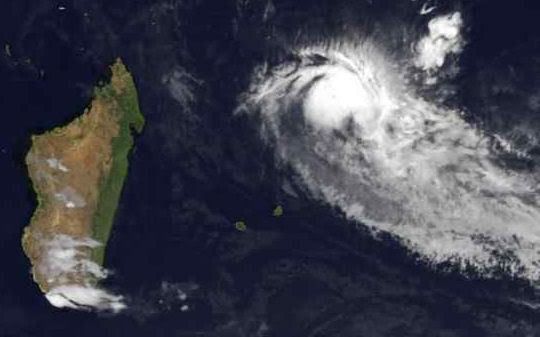
Klopt, Somalië en Yemen af en toequote:
[..]
Madagascar krijgt vaak bezoek.
[ afbeelding ]
Regendrama in Jemen
SAYOUN - Overstromingen in Zuid-Jemen hebben tot gisteravond aan zeker 61 mensen het leven gekost.
De Jemenitische autoriteiten hebben dat bekendgemaakt.
De politie in de afgelegen provincie Hadramaut waarschuwde dat het dodencijfer verder kan oplopen omdat nog tientallen mensen worden vermist.
Vooral de zuidoostelijke provincies Hadramaut en Mahara zijn zwaar getroffen door het noodweer in de regio. Honderden woningen zijn vernietigd. Gezinnen die niet dakloos zijn geraakt, kampen wel met ernstige wateroverlast. Inmiddels wordt geprobeerd met helikopters tenten, medicijnen en andere noodgoederen naar het gebied te brengen, dat door de modderstromen over de weg niet meer te bereiken is.
Jemen werd gisteren opnieuw door veel regen getroffen, hoewel de regenval in Hadramaut niet zo zwaar was als eerder. De storm, die de regens met zich meebracht, begon al weken geleden.
De historische hoogbouw in woestijnstad Shibam, die op de werelderfgoedlijst van Unesco staat, wordt bedreigd. De stad, met zo'n 20.000 inwoners, is volledig geïsoleerd en kampt met elektricteit- en drinkwaterproblemen. Inmiddels heeft Jemen een internationaal hulpverzoek laten uitgaan.
Minister Bert Koenders van Ontwikkelingssamenwerking vertrekt vandaag voor een driedaags werkbezoek naar Jemen. Hij zal zich daar onder meer op de hoogte laten stellen van de gevolgen van de overstromingen.
Het bezoek van Koenders staat in het teken van dertig jaar betrekkingen tussen Nederland en het streng islamitische land, dat jaarlijks ongeveer 30 miljoen euro ontwikkelingsgeld van Nederland ontvangt.
Jemen is een van de armste en minst ontwikkelde landen van de wereld. Het scoort slecht op internationale ranglijsten over de staat van het onderwijs, de gezondheidszorg, veilige watervoorzieningen, de positie van vrouwen, mensenrechten en persvrijheid.
De regering in de hoofdstad Sanaa heeft bovendien te kampen met rebellie en geweld in het voormalige onafhankelijke noorden, tribale onrust in het zuidoosten en een toestroom van Somalische vluchtelingen langs de kust


Tropical Depression Three, Gulf of Aden
The third tropical cyclone of the season in the northern Indian Ocean brought rare rains to the desert regions of Yemen and Oman in the third week of October 2008 after the storm hooked around the Horn of Africa and entered the Gulf of Aden. This image of the storm was captured on October 23, 2008, by the Moderate Resolution Imaging Spectroradiometer (MODIS) on NASA’s Terra satellite.
Tropical Storm Three formed in the Indian Ocean southeast of the island of Socotra and headed northwest over the island. It skirted the Horn of Africa and headed west. The storm only briefly reached “Tropical Storm” status before it weakened to a tropical depression. By the time of this image, the storm did not have the iconic pinwheel shape and distinct eye of a powerful storm, but hints of its cyclonic nature were visible. Airflow spiraled inward in a counterclockwise direction toward a storm center located near the eastern shoreline of Yemen. Two patches of intensely bright clouds around this center of rotation signal areas of severe thunderstorms.
According to a blog posting by international meteorologist Jim Andrews with Accuweather.com, the storm was bringing scattered downpours over areas that are accustomed to going a year or more without significant rainfall. Local flash flooding was likely along the coast of Yemen, Oman, and northeastern Somalia.
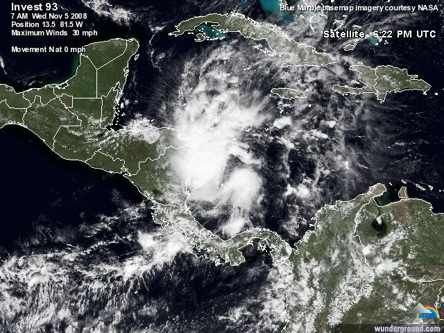
Misschien dat dit nog gaat uitgroeien tot iets groots.
Het systeem ligt nu voor de kust van Nicaragua.
navy
Het systeem ligt nu voor de kust van Nicaragua.
navy

Dit is denk ik ook de laatste van 2008quote:Op donderdag 6 november 2008 18:18 schreef Co_OL het volgende:
Het water is al een stuk kouder zag ik dus CAT 4 orkies zullen er niet meer onstaan denk ik
Paloma gaar waarschijnlijk nog een categorie 3 worden.
quote:Strengthening Hurricane Paloma threatens Caymans 07 Nov 2008 18:29:40 GMT
GEORGE TOWN, Nov 7 (Reuters) - Residents of the Cayman Islands braced for Hurricane Paloma on Friday as it strengthened rapidly while bearing down on the wealthy British territory on a path that could also threaten Cuba.
"No one thought this storm would come in so quickly," said Levonne Johnston," a resident of George Town, the Cayman Islands capital, which was expected to take a lashing from the eighth hurricane of the 2008 Atlantic storm season.
"We are just doing whatever we can with the couple of hours we have left and then knuckle down and wait out the storm," Johnston said.
Paloma doused Honduras with heavy rains on Thursday, adding to misery in the impoverished Central American country where the U.N. estimates 70,000 people have been made homeless by recent storms.
It posed no threat to U.S. oil installations in the Gulf of Mexico on its passage northward but U.S. forecasters said it was strengthening on Friday and could become a "major" hurricane with maximum sustained winds of at least 111 miles per hour (178 kph) by Saturday.
At 1 p.m. EST (1800 GMT), Paloma was 60 miles (100 km) south of Grand Cayman and moving north-northeast at 6 mph (10 km), the U.S. National Hurricane Center said.
Its top sustained winds increased to 90 mph (150 kph), making Paloma a strong Category 1 hurricane on the five-step Saffir-Simpson intensity scale, the Miami-based center said.
Rainfall totaling up to 12 inches (30 cm) was expected over parts of the Cayman Islands and its national weather service forecast waves rising up to 30 feet (9 metres) off the islands, triggering potentially dangerous coastal storm surges.
CATEGORY 3 POTENTIAL
The hurricane center said the storm was likely to become a Category 2 hurricane later on Friday, before possibly growing into a fearsome Category 3. Hurricane Katrina was a Category 3 storm when it came ashore near New Orleans in 2005 and swamped the vulnerable, low-lying city.
"The center of Paloma will pass near the Cayman Islands late today or early Saturday and be approaching the coast of central Cuba late Saturday," the hurricane center said.
Government offices were closed and the storm forced the postponement of a national festival known as Pirates Week, a major tourist draw. Many tourists already had cut short their vacations in order to evacuate.
"We're going to Cancun where it's sunny," said Steve Keith, a visitor who was married in Grand Cayman on Thursday night and had intended to spend his honeymoon there.
Paloma came in the last month of what experts correctly predicted would be a busier than normal storm season.
It was expected to hit Cuba after its brush with the Cayman Islands, though possibly as a weakening hurricane.
The communist-ruled island still is dealing with devastating effects from two powerful hurricanes that caused more than $5 billion in damage two months ago.
The Atlantic hurricane season runs from June 1 to Nov. 30. (Writing by Tom Brown and Jane Sutton; Editing by Michael Christie and Bill Trott)


quote:Hurricane Paloma strengthens, heads for Cuba 08 Nov 2008 15:40:40 GMT
Source: Reuters
(Updates with details, quotes, new storm position)
By Shurna Robbins
GEORGE TOWN, Nov 8 (Reuters) - Hurricane Paloma strengthened into an "extremely dangerous" Category 4 storm on Saturday as it pounded the wealthy British Caribbean territory of the Cayman Islands and headed toward storm-battered Cuba.
Paloma's eye passed just to the east of Grand Cayman, the main island and home to most of the more than 50,000 people in the important offshore financial center, but damage appeared to be light and there were no immediate reports of deaths.
"There is no damage to central George Town, where the bulk of the financial sector is located," said Cindy Scotland, an official with the Cayman Islands Monetary Authority. "So there is no reason to think there has been any damage in any way to the infrastructure of the financial services sector."
"The Authority does not expect any reports of significant, if any, interruptions in business," she said.
Cuba, already hammered this year by hurricanes Gustav and Ike, declared an emergency in central and eastern parts of the island, canceled all national air and ground transportation and began evacuating hundreds of thousands of residents.
Authorities issued an "all-clear" early Saturday for Grand Cayman but cautioned residents to move about carefully. Power was out in some parts of the island and the streets of George Town were littered with tree branches.
Paloma's sustained winds increased to 140 miles per hour (225 km per hour) early on Saturday as the storm hurtled across the group's smaller islands, Cayman Brac, home to 1,800 people, and Little Cayman, with a population of about 100.
Gov. Stuart Jack asked that the British auxiliary ship Wave Ruler head straight to the smaller islands after the storm passes.
"Paloma is now an extremely dangerous category four hurricane on the Saffir-Simpson scale," the U.S. National Hurricane Center said.
Category 4 hurricanes can generate tidal surges up to 18 feet (5.5 metres) above normal and their winds can tear off the roofs and blow out the doors and windows of small homes.
Hurricane Ivan had 160 mph (260 kph) winds when it slammed the Caymans in 2004, causing extensive damage. But the islands and their solid structures are considered less vulnerable than other Caribbean islands to the fierce tropical storms that churn through between June and the end of November each year.
Paloma doused Honduras with heavy rains as it formed on Thursday, adding to misery in the impoverished Central American country where the United Nations estimates 70,000 people have been made homeless by recent storms.
It posed no threat to U.S. oil installations in the Gulf of Mexico.
In Cuba, Paloma was forecast to beat a northeast path through central Camaguey and eastern Las Tunas provinces. It was expected to weaken before hitting Cuba as a Category 3 storm, the forecasters said.
"I don't want to talk or hear about hurricanes, because they have already driven me crazy. First one came through from the north, now one is heading here from the south," Camaguey resident Carlos Martinez said. "I hope another doesn't fall from the sky."
Ailing former President Fidel Castro put damage from previous storms Ike and Gustav at $8 billion and blamed global warming for the number and power of the storms this year.
In a written statement published on Saturday, Castro rejected any aid from the United States before it was even offered, demanding instead that Washington lift economic sanctions tightened by U.S. President George W. Bush.
"Dignified conduct will again be needed if the head of the empire, who has been the chief instigator behind the genocidal blockade against our country, were to again offer pitiful aid. It will most surely be rejected," said Castro, who has not appeared in public since intestinal surgery in July 2006.
By 10 a.m. EST (1500 GMT), Paloma was about 130 miles (210 km) east-northeast of Grand Cayman Island and about 140 miles (225 km) southwest of Camaguey, Cuba, and moving east-northeast near 9 mph (14 kph), the hurricane center said. (Additional reporting by Marc Frank in Havana; writing by Jim Loney, editing by Vicki Allen)

ging wel erg snel naar CAT4.
Dostojewski: "Je kunt je niet van je eigen gezond verstand overtuigen door je buurman op te sluiten."
wel raar dat het ineens ophoud met de orkaan!
je zou toch zeggen dat op zee weer aan kracht toe neemt?
je zou toch zeggen dat op zee weer aan kracht toe neemt?
TS Anika
TS Three
Het orkaanseizoen in de Zuid Indische/West Australische oceaan lijkt ook van start te gaan
TS Three
Het orkaanseizoen in de Zuid Indische/West Australische oceaan lijkt ook van start te gaan
Yup....quote:Op donderdag 20 november 2008 09:49 schreef Frutsel het volgende:
Het orkaanseizoen in de Zuid Indische/West Australische oceaan lijkt ook van start te gaan
Cyclone 06B over Sri Lanka and India
On November 26, 2008, Cyclone 06B was passing northwest over the island of Sri Lanka and approaching the southern tip of India. This image of the storm was captured by the Moderate Resolution Imaging Spectroradiometer (MODIS) on NASA’s Terra satellite. The storm’s organization was being affected by passage over land. The clouds had a spiral pattern, but they were becoming ragged. According to reports from the Joint Typhoon Warning Center at 5:30 p.m. local time in Sri Lanka, the storm had sustained winds of 50 knots (58 mph), with gusts of up to 65 knots (75 mph).

On November 26, 2008, Cyclone 06B was passing northwest over the island of Sri Lanka and approaching the southern tip of India. This image of the storm was captured by the Moderate Resolution Imaging Spectroradiometer (MODIS) on NASA’s Terra satellite. The storm’s organization was being affected by passage over land. The clouds had a spiral pattern, but they were becoming ragged. According to reports from the Joint Typhoon Warning Center at 5:30 p.m. local time in Sri Lanka, the storm had sustained winds of 50 knots (58 mph), with gusts of up to 65 knots (75 mph).
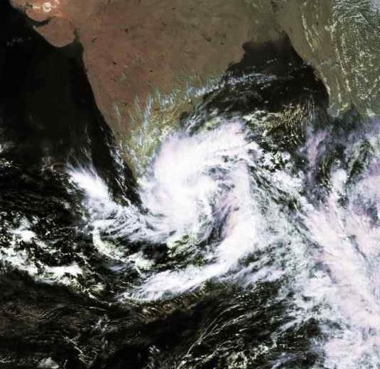
quote:Hurricane-seizoen breekt records
29 november 2008 - Het orkaanseizoen dat dit weekeinde eindigt heeft tal van records opgeleverd. Liefst zes opeenvolgende orkanen, Dolly, Edouard, Fay, Gustav, Hanna en Ike, bereikten het vasteland van de VS. Dat is zolang gegevens bekend zijn, nooit eerder gebeurd.
Vijf hurricanes (de Amerikaanse benaming voor een tropische orkanen) tussen juli en november groeiden uit tot een zware (major) hurricane van klasse 3 of hoger met gemiddelde windsnelheden van meer dan 176 km/uur. Cuba kreeg drie zware hurricanes te verwerken, Gustav, Ike en Paloma. Midden september trok Ike met windsnelheden van 165 km/uur dwars over het eiland en liet de hurricane en spoor van vernieling achter in Havana. Eerder die maand schreef Gustav geschiedenis in Cuba. Die hurricane deed volgens het Cubaanse Meteorologische Instituut de windmeters uitschieten tot recordsnelheden van 340 km/uur. Bertha bleef 17 dagen achtereen actief en was voor de maand juli de langs levende hurricane sinds het begin van de waarnemingen.
Amerikaanse weervoorspellers van het NOAA Climate Prediction Center hadden een bovengemiddeld hurricane-seizoen verwacht. Uiteindelijk is het seizoen nog actiever geworden en zijn er in totaal 16 tropische stormen of orkanen ontstaan.
Of dit veel is hangt er sterk van af van wat als normaal wordt bestempeld. De jaren 1970 en 1980 telden relatief weinig tropische stromen (circa 9 per jaar). Sinds 1995 is het gemiddelde aantal stormen en orkanen flink toegenomen en tegenwoordig is een aantal van 12-16 tropische stormen normaal. Het hurricane-seizoen van 2005 telde liefst 28 tropische stormen en orkanen. De toename komt voor een deel door natuurlijke variaties, maar ook de waarnemingen zijn verbeterd, zodat er minder aan de aandacht ontsnapt. Een relatie van het grotere aantal stormen met de opwarming van de aarde is tot nu toe niet gevonden.
Vorig jaar was het hurricane-seizoen, dat op 1 juni van start gaat en een half jaar duurt, vrij rustig, maar die rust was betrekkelijk. Voor het eerst sinds 1851 kwamen twee hurricanes van de zwaarste categorie, klasse 5, aan land. Met gemiddelde windsnelheden groter dan 248 km/uur zijn dat de meest verwoestende orkanen. De namen van deze rampzalige orkanen, Dean en Felix, zijn inmiddels door de Wereld Meteorologische Organisatie (WMO) geschrapt van de namenlijst. Ook Noel keert nooit meer terug op de lijst. Deze orkaan werd niet sterker dan een klasse 1 maar veroorzaakte enorme overstromingen in de Domenicaanse Republiek waardoor zeker 160 mensen het leven verloren. Het is de gewoonte om namen van catastrofale orkanen niet opnieuw te gebruiken.
De storm- en hurricanenamen van 2008 waren Arthur, Bertha, Cristobal, Dolly, Edouard, Fay, Gustav, Hanna, Ike, Josephine, Kyle, Laura, Marco, Nana, Omar en Paloma.
Het aantal tropische stormen (blauw) en sterke orkanen (rood) in het Caraïbisch gebied en boven de Noord-Atlantische Oceaan per jaar vanaf 1944 (Landsea et al). De getrokken lijnen geven het 10-jaars lopend gemiddelde.

Die kan ook nog wel uitgroeien tot meer als tropische storm. Het water is er warm genoeg voor.quote:Op donderdag 4 december 2008 09:10 schreef Frutsel het volgende:
SriLanka krijgt er nog eentje op bezoek
[ afbeelding ]
Dolphin koerst langzaam op de Filipijnen af
[ Bericht 10% gewijzigd door Frutsel op 17-12-2008 14:02:49 ]
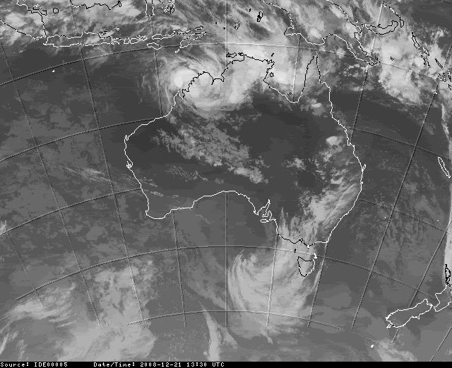
21st December 2008, 19:38 WST
Ex-tropical cyclone Billy is expected to pick up strength on Monday and again threaten Western Australia's coastline.
It's feared flooding, heavy rain and gale-force winds expected late on Monday and on Tuesday could threaten small indigenous communities.
Two remote indigenous communities, Kulumburu and Oombulgurri, in Western Australia's far north, are already cut off by floodwaters.
Billy was downgraded to a tropical low category on the weekend after earlier packing destructive winds of up to 130km/h on Saturday morning.
It will almost certainly become a cyclone again on Monday, a Bureau of Meteorology spokesman told AAP.
"It is moving west across the Kimberley and is expected to move off the coast into tropical water and early Monday morning. That will be favourable for it to intensify," he said.
Gales may develop between Kalumburu and Beagle Bay overnight or during Monday and extend down the coast to Broome and Wallal late on Monday or Tuesday, he said.
The roads and the airstrips are closed at Kulumburu and Oombulgurri.
Both communities had been cut off by floods before and were next to rivers that fed into the ocean, State Emergency Services (SES) spokesman Allen Gale told AAP.
"It is not new for them but we watch it closely as they are effectively isolated," he said.
"They have plenty of stock, there is plenty of water, obviously, and they are resilient. The authorities communicate with them regularly and they have their own plans in place."
Ik ben een eckte rapnegert
Intense Tropical Cyclone BILLY is een categorie 3.
quote:Cyclone Billy headed for Port Hedland
A cyclone warning is current for coastal communities on the Western Australia coastline, from Port Hedland to Mardie, the Bureau of Meteorology (BoM) advises.
A previous cyclone warning from Pardoo to Port Hedland has been cancelled.
At 3am (WDT) Severe Tropical Cyclone Billy was reported to be located well to the north of Port Hedland and moving steadily on a west northwesterly track.
Wind gusts of up to 100km/h may develop between Port Hedland and Mardie on Thursday if Billy takes a more southwesterly track.
A blue alert has been issued for people in or near communities from Pardoo to Port Hedland.
Over een paar dagen begint het nieuwe seizoen weer
quote:OAA (National Oceanic and atmospheric Administration) verwacht een orkaanseizoen dat voldoet aan het klimatologisch gemiddelde.
De laatste jaren was het orkaanseizoen vrij actief met als meest opvallende jaar 2005, toen een groot aantal hurricanes het levenslicht zagen. De meeste bekendheid kreeg hurricane Katrine die enorme schade aanrichtte in New-Orleans. NOAA gaat uit van 14 tropische stormen waarvan een aantal uit zullen groeien tot een hurricane.
Voorlopig gaat men er van uit dat er 1 a 3 grote hurricanes zullen ontstaan. Dit zijn orkanen die vallen in de categorie 3 of meer (op een schaal van 5). Het seizoen start op 1 juni. Dat het seizoen iets minder actief zou kunnen zijn wordt o.a. veroorzaakt door de mogelijk opkomst van een El Niño