WKN Weer, Klimaat en Natuurrampen
Lees alles over het onstuimige weer op onze planeet, volg orkanen en tornado's, zie hoe vulkanen uitbarsten en hoe Moeder Aarde beeft bij een aardbeving. Alles over de verwoestende kracht van onze planeet en tal van andere natuurverschijnselen.


tijd voor een update:
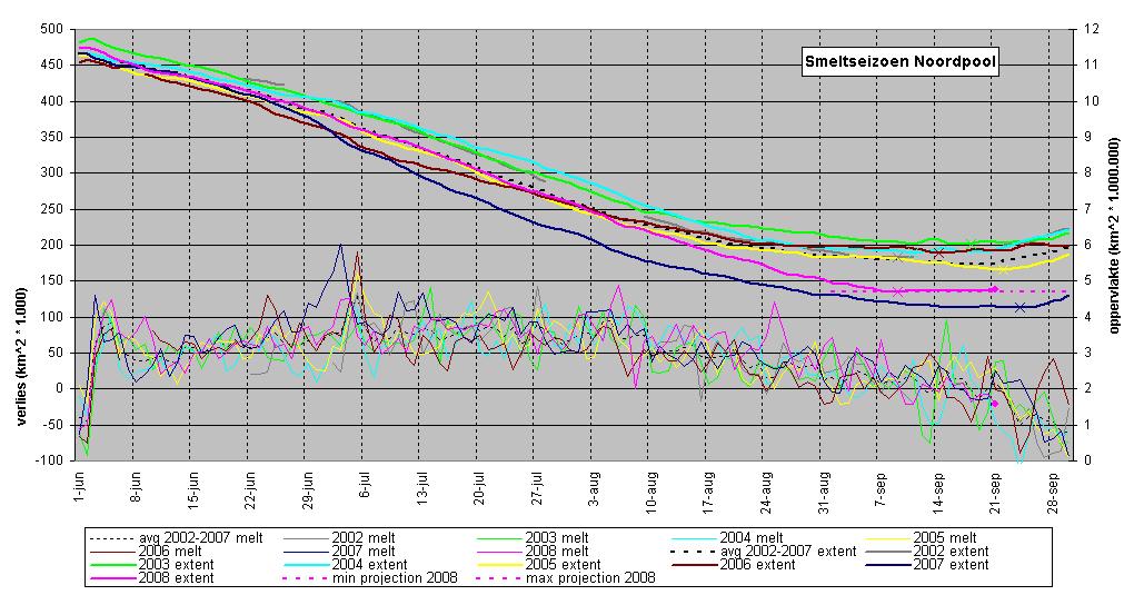
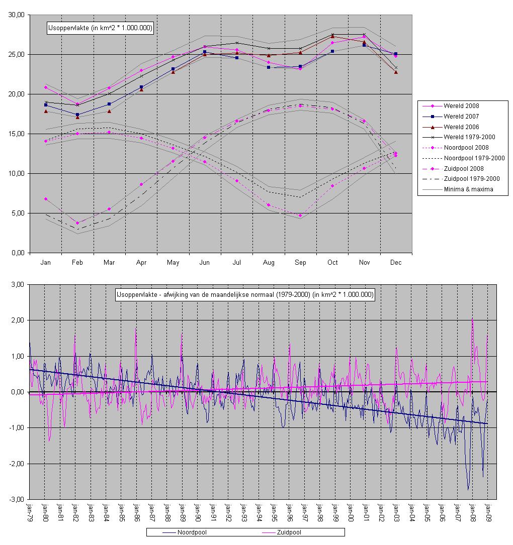
In de afgelopen zeven dagen is het ijs in totaal ruim 5000 vierkante kilometer gegroeid ten opzichte van vorige week. De minimale oppervlakte (extent) werd bereikt op 9 september, sindsdien is het een aantal dagen gegroeid, en een aantal dagen nog iets geslonken. Het is duidelijk dat we op de grens zitten tussen wegsmelten en aangroeien. Op zich is 9 september geen buitensporig vroege datum voor minimum extent, maar gezien de hoge smelt in de afgelopen weken hadden weinig mensen verwacht dat het nu al zou gebeuren. En het zou ook best nog kunnen dat er in de komende één tot twee weken nog flink wat vanaf gaat, maar voorlopig ziet het er veel beter beter uit dan een week geleden.
Voorspelde minimum extent op basis van wat er in andere jaren nog gesmolten is na 15 september is nu tussen 4,71 en 4,54 miljoen vierkante kilometer, tegen 4,29 in 2007 (gestippelde roze lijn in september). De dagen van minimum extent in eerdere jaren (en 2008 tot nu toe) zijn aangegeven met een kruisje.
Het NSIDC bericht dat minimum extent waarschijnlijk geweest is, hun 5-daags gemiddelde laat nu ook een groei zien. Zie bericht hier: http://nsidc.org/arcticseaicenews/index.html
Als het hierbij blijft, zou dat een 9,4% groei ten opzichte van 2007 betekenen, en dat met het eerstejaars ijs waarvan de voorspellingen waren dat het de zomer niet zou overleven. Op de lange termijn-trend heeft het allemaal weinig invloed, die blijft flink dalen.
Als het hierbij blijft, zou dat een 9,4% groei ten opzichte van 2007 betekenen, en dat met het eerstejaars ijs waarvan de voorspellingen waren dat het de zomer niet zou overleven. Op de lange termijn-trend heeft het allemaal weinig invloed, die blijft flink dalen.
ook afgelopen week zijn er enkele dagen geweest met wat groei en wat verlies, maar het minimum van 9 september is niet meer gehaald, en ondertussen is het verschil meer dan 65.000 vierkante kilometer, meer dan er in recente jaren nog gesmolten is na 21 september. Daarmee lijkt het er op dat het minimum voor 2008 bekend is, volgende week weten we het waarschijnlijk zeker. Volgens de IARC-JAXA data lag het minimum 11,4% hoger dan het record van 2007.
grafiek:
grafiek:
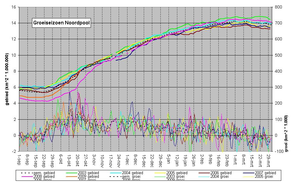
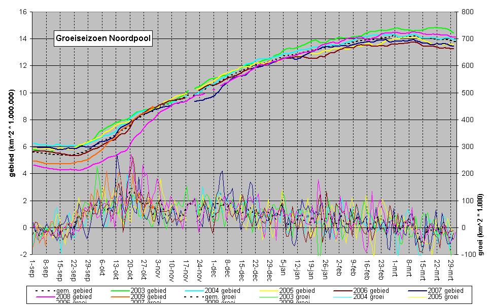
Goed, afgelopen week is het echte grote aanvriezen van de noordpool weer begonnen. Alleen op donderdag werd er nog een miniscule hoeveelheid ijs verloren, maar verder is er in enorm tempo ijs bijgekomen. Daarmee is het minimum van 9 september definitief geworden, en kunnen we voorzichtig blij zijn dat de voorspellingen voor dit jaar niet zijn uitgekomen. Tijdens het aanvriezen zal ik ook wel af en toe een update doen, maar tenzij het er op gaat lijken dat er records gaan sneuvelen lijkt een wekelijkse update me wat overdreven. Wie het wel graag vaker wil volgen kan hier de dagelijkse data downloaden: http://www.ijis.iarc.uaf.edu/seaice/extent/plot.csv
Het Excel sheetje waar ik de grafiekjes in maak kan ik ook wel geven, pm me even als je het wilt hebben.
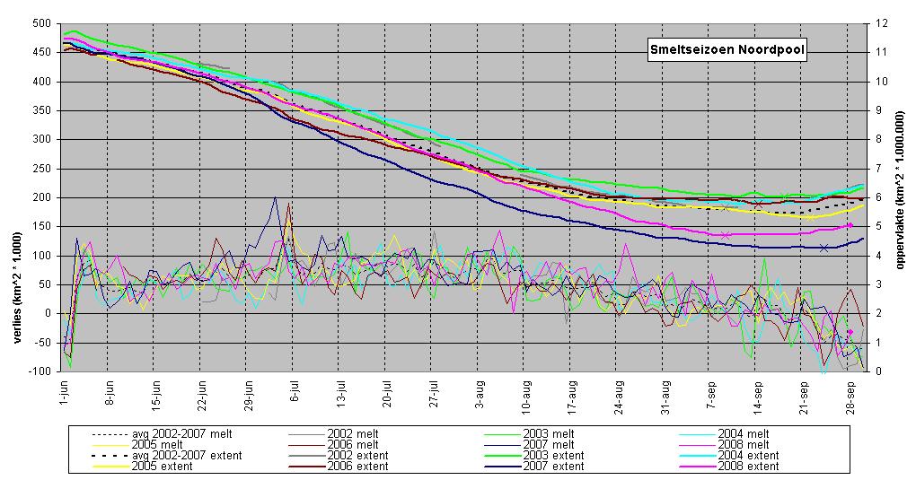
Hier in ieder geval de grafiek met de eindstand van het smeltseizoen 2008:
Het Excel sheetje waar ik de grafiekjes in maak kan ik ook wel geven, pm me even als je het wilt hebben.
Hier in ieder geval de grafiek met de eindstand van het smeltseizoen 2008:
In elk geval dank voor al je updates, Aredquote:Op maandag 29 september 2008 16:38 schreef Ared het volgende:
Goed, afgelopen week is het echte grote aanvriezen van de noordpool weer begonnen. Alleen op donderdag werd er nog een miniscule hoeveelheid ijs verloren, maar verder is er in enorm tempo ijs bijgekomen. Daarmee is het minimum van 9 september definitief geworden, en kunnen we voorzichtig blij zijn dat de voorspellingen voor dit jaar niet zijn uitgekomen. Tijdens het aanvriezen zal ik ook wel af en toe een update doen, maar tenzij het er op gaat lijken dat er records gaan sneuvelen lijkt een wekelijkse update me wat overdreven. Wie het wel graag vaker wil volgen kan hier de dagelijkse data downloaden: http://www.ijis.iarc.uaf.edu/seaice/extent/plot.csv
Het Excel sheetje waar ik de grafiekjes in maak kan ik ook wel geven, pm me even als je het wilt hebben.
Hier in ieder geval de grafiek met de eindstand van het smeltseizoen 2008:
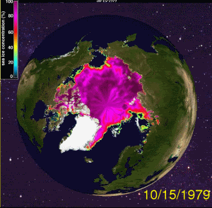
[ afbeelding ]
Ik heb het erg op prijs gesteld.
Huidige trend atmosf. CO2 Mauna Loa: 411 ppm ,10 jaar geleden: 387 ppm , 25 jaar geleden: 358 ppm
nou, de maandelijkse cijfers van het NSIDC zorgen voor een nieuw record, dus toch maar een update.
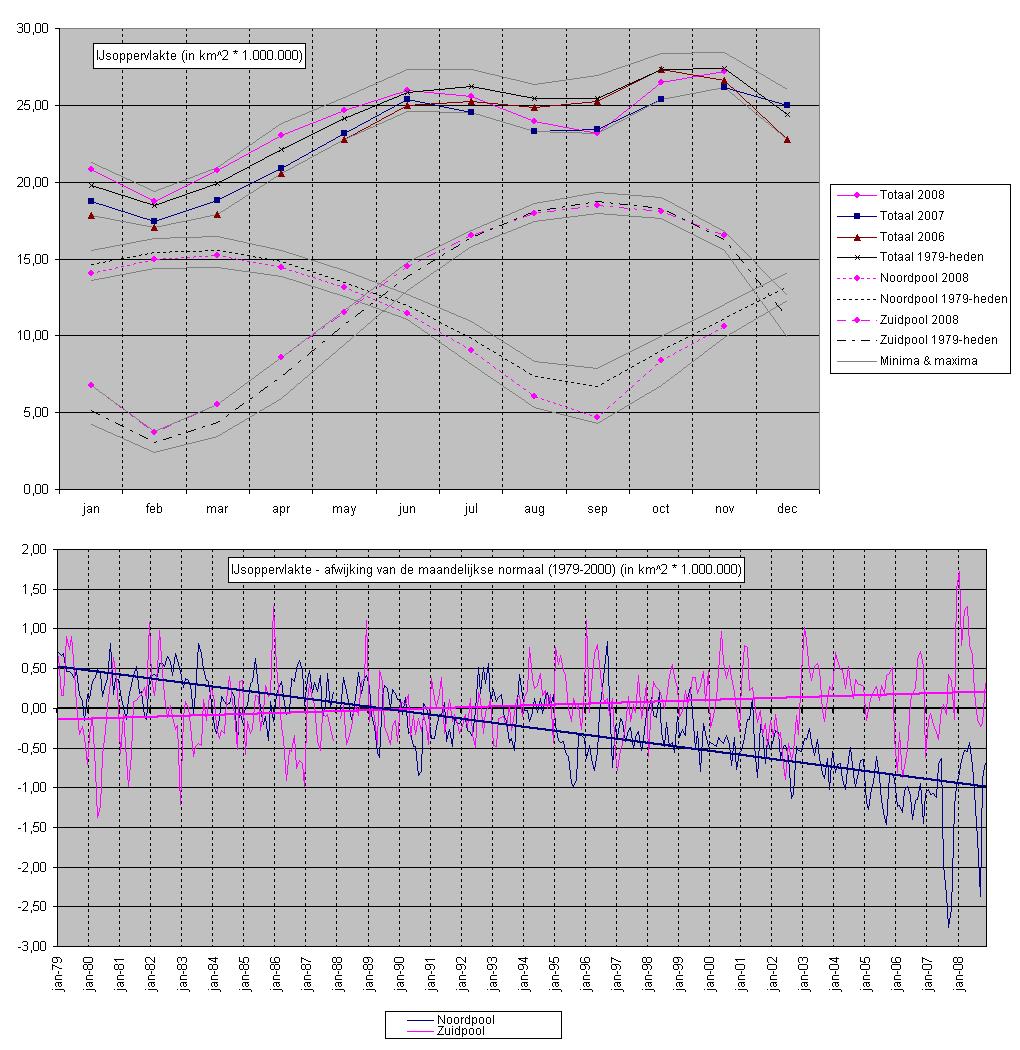
In ieder geval sinds 1979 is de gemiddelde wereldwijde hoeveelheid zee-ijs in september niet zo laag geweest als afgelopen maand. Toen ik begon met het volgen van het zee-ijs, had ik niet verwacht dat de verschillen binnen een jaar zo groot zouden zijn. September 2007 was een dieptepunt, maart 2008 was bijna een record hoogtepunt, en nu is er weer een nieuw dieptepunt. Let op dat de noordpool noch de zuidpool nieuwe records hebben neergezet deze maand (al was de noordpool er dicht bij), alleen de combinatie ervan is in september nog niet zo laag geweest. De onderste grafiek laat duidelijk zien dat de enorme pieken en dalen van afgelopen jaar redelijk ongekend zijn sinds we de boel met satellieten in de gaten houden.
De langjarige trends zijn nagenoeg ongewijzigd, -0,52 miljoen vierkante kilometer per decennium voor de noordpool, +0,12 miljoen vierkante kilometer per decennium voor de zuidpool.
grafiekjes:

p.s. de middelste grafiek vind ik redelijk weinig toevoegen in vergelijking met de grafiekjes van de IARC-JAXA data, dus die zal ik voortaan in NSIDC overzichten weg laten, maar aangezien dit het dieptepunt van het jaar is heb ik 'm er nog maar even bij gelaten.
In ieder geval sinds 1979 is de gemiddelde wereldwijde hoeveelheid zee-ijs in september niet zo laag geweest als afgelopen maand. Toen ik begon met het volgen van het zee-ijs, had ik niet verwacht dat de verschillen binnen een jaar zo groot zouden zijn. September 2007 was een dieptepunt, maart 2008 was bijna een record hoogtepunt, en nu is er weer een nieuw dieptepunt. Let op dat de noordpool noch de zuidpool nieuwe records hebben neergezet deze maand (al was de noordpool er dicht bij), alleen de combinatie ervan is in september nog niet zo laag geweest. De onderste grafiek laat duidelijk zien dat de enorme pieken en dalen van afgelopen jaar redelijk ongekend zijn sinds we de boel met satellieten in de gaten houden.
De langjarige trends zijn nagenoeg ongewijzigd, -0,52 miljoen vierkante kilometer per decennium voor de noordpool, +0,12 miljoen vierkante kilometer per decennium voor de zuidpool.
grafiekjes:
p.s. de middelste grafiek vind ik redelijk weinig toevoegen in vergelijking met de grafiekjes van de IARC-JAXA data, dus die zal ik voortaan in NSIDC overzichten weg laten, maar aangezien dit het dieptepunt van het jaar is heb ik 'm er nog maar even bij gelaten.
quote:Op donderdag 19 juni 2008 12:52 schreef Basp1 het volgende:
De veranderde wind richtingen kunnen ook weer te danken zijn aan de hogere temperaturen.
Verder heb ik dan een volgende vraag, als de verandere luchtdruk verdeling vanaf het begin van deze eeuw voor de niet standaard windrichtingen zorgt dan zouden we toch in de grafieken van de afgelopen 7 jaar dezelfde dip moeten zien.
Zo vervelend met zulke complexe systemen dat niemand weet wat de leidende factoren zijn.
Net zoals men in de global dimming documantaire van de BBC de uitspraak doet dat de droogte in afrika veroorzaakt was door de vervuiling in europa, en nu de vervuiling iets minder wordt de droogtes in afrika ook wat afnemen.


http://www.nos.nl/nos/art(...)1C92ECD480B15CE.htmlquote:Noordpool behoudt iets meer ijs
Op de Noordpool is de afgelopen zomer iets minder ijs gesmolten dan in de zomer van vorig jaar. Het KNMI meldt op basis van gegevens van het Amerikaanse National Snow and Ice Data Center dat er in september gemiddeld 4,67 miljoen vierkante meter zeeijs lag. Dat was in september 2007 4,28 miljoen.
De ijssmelt van vorig jaar was een laagterecord. De opwarming van de aarde was niet de enige oorzaak, vermoedt het KNMI. Ook speelde mee dat de zon vorig jaar aanzienlijk vaker scheen en dat er veel warme lucht uit het zuiden kwam.
Deskundigen waren bang dat de Noordpool deze zomer vrijwel ijsvrij zou zijn.
Op zaterdag 15 augustus 2009 23:05 schreef eer-ik het volgende:
Ik vind je sig nogal denigrerend.
Ik vind je sig nogal denigrerend.
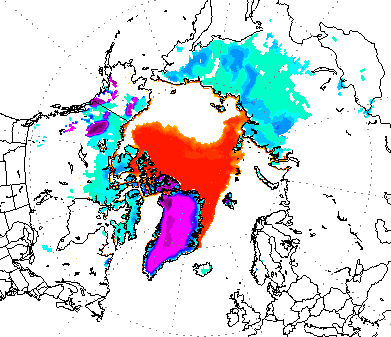

De opmars is eerder begonnen, kijken hoe het zich ontwikkelt, maar van plaatjes zoals de onderstaande kun je toch echt niet vrolijk worden hoor:quote:Op woensdag 15 oktober 2008 19:59 schreef aloa het volgende:
De noordpool vriest in rap tempo weer dicht.
[ afbeelding ]

De snelheid van aanvriezen is zelden of nooit (in het satelliet tijdperk) zo hoog geweest als afgelopen maand. Maar dat komt natuurlijk ook omdat zelden of nooit zo vlak bij de pool open water is geweest in deze maanden. Maar ook in absolute aantallen ligt er nu weer meer ijs (extent) dan het 2002-2007 gemiddelde. In dit tempo gaat het ijs spoedig groter worden dan vrijwel alle recente jaren. Maar goed, in de zomer hebben we gezien dat "in dit tempo" gevaarlijke uitspraken zijn, tempo kan zomaar in een maand gigantisch toe- of afnemen. Er is ook weinig correlatie tussen hoe snel het ijs vroeg in het seizoen groeit en hoe groot het uiteindelijk wordt. Eind oktober 2005 lag er meer ijs dan alle jaren 2002-2007, eind februari 2006 lag er minder ijs dan al die jaren. In 2007 was het net andersom, van laatste plaats naar eerste in diezelfde tijd.
En wat er nu bij komt is natuurlijk wel relatief dun, eerstejaars ijs. Ik wacht met smart op de dag dat we het smelten en aangroeien kunnen volgen in termen van volume ijs in plaats van "oppervlakte met x procent ijsdekking".
En wat er nu bij komt is natuurlijk wel relatief dun, eerstejaars ijs. Ik wacht met smart op de dag dat we het smelten en aangroeien kunnen volgen in termen van volume ijs in plaats van "oppervlakte met x procent ijsdekking".


yep, van de data die IARC-JAXA in de aanbieding heeft, staat dit jaar alleen nog onder 2002 en 2003, maar boven 2004, 2005, 2006, 2007 en het 2002-2007 gemiddelde. De groei-ratio is ook nog altijd groter dan 2002 en 2003, dus het zou me niet verbazen als die ingehaald gaan worden.
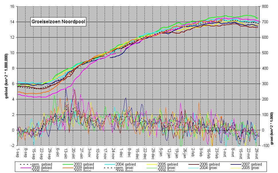
Let op dat ik in de grafiek hierboven de groeiseizoenen genoemd heb naar het jaar waarin het maximum valt. We zitten nu dus in seizoen 2009, en t/m 31 december moet je van alle seizoenen één aftrekken voor het juiste kalenderjaar.
Let op dat ik in de grafiek hierboven de groeiseizoenen genoemd heb naar het jaar waarin het maximum valt. We zitten nu dus in seizoen 2009, en t/m 31 december moet je van alle seizoenen één aftrekken voor het juiste kalenderjaar.
quote:'Megadam kan Noordpoolijs beschermen'
AMSTERDAM - Een Nederlands onderzoeker heeft een plan gelanceerd om het ijs op de Noordpool te beschermen met een gigantische dam.
Klimaatdeskundige Rolf Schuttenhelm pleit voor de aanleg van een ruim 300 kilometer lange dam in de Beringzee. Zo'n bouwwerk kan de omstandigheden voor ijsvorming op de Noordpool volgens hem aanzienlijk verbeteren.
Zijn plan is gepubliceerd op de website www.cleverclimate.org, een nieuw internationaal platform waarop wetenschappers grootschalige en vernieuwende plannen tegen de opwarming van de aarde kunnen lanceren.
Alaska
De dam van Schuttenhelm zou gebouwd moeten worden tussen St. Lawrence Island en het vasteland van Alaska en Siberië. Er zou dan in verhouding meer zoet water vanuit de rivier de Yukon naar de Noordpool kunnen stromen. En hoe minder zout zeewater is, hoe makkelijker het bevriest en hoe trager het smelt.
Het plan zou ijsvorming ook bevorderen, omdat de stroming in het Noordpoolwater lokaal afneemt door de plaatsing van een dam. Verder zou de temperatuur van het water dalen, omdat er minder relatief warm water wordt aangevoerd vanuit de Stille Oceaan. Andere klimaatonderzoekers nemen het plan voor de zogenaamde St. Lawrence Dam serieus.
Interessant idee
"Dit is een interessant idee", zo reageerde de Amerikaanse wetenschapper Walt Meier van het National Snow and Ice Data Centre (NSIDC), dat toezicht houdt op de Beringzee.
"Dit plan kan zeker de genoemde impact hebben op het klimaat. Al zijn er mogelijk ook onvoorziene consequenties. Een dramatische verandering van de stroming in de Noordpool zou ook invloed kunnen hebben op de Stille Oceaan en de omliggende landen. Verder is het een behoorlijke financiële en technologische uitdaging. De Beringstraat is misschien smal, maar deze dam is nog steeds een stuk groter dan de gemiddelde dam."
Schuttenhelm vindt het vooral belangrijk dat de discussie over klimaatplannen wordt aangewakkerd. "Het is waar dat er nu nog te veel onzekerheden in het plan zitten. Maar we moeten wel over deze schaal van oplossingen durven nadenken. Als we niets doen, zijn de gevolgen enorm. Met dit plan wil ik vooral een open debat onder geschoolde klimaatonderzoekers uitlokken. En ik blijf natuurlijk een Nederlander. Ik heb vertrouwen in de mogelijkheden van dijken en dammen."
Onzinnig plan men weet niet eens of het echt zal werken zo'n dam.
Laten we als mensheid gewoon als eerste ons gaan inzetten op een duurzame samenleving zonder fossiele brandstoffen.
Laten we als mensheid gewoon als eerste ons gaan inzetten op een duurzame samenleving zonder fossiele brandstoffen.
Arctic is melting even in winter
quote:The Arctic icecap is now shrinking at record rates in the winter as well as summer, adding to evidence of disastrous melting near the North Pole, according to research by British scientists.
They have found that the widely reported summer shrinkage, which this year resulted in the opening of the Northwest Passage, is continuing in the winter months with the thickness of sea ice decreasing by a record 19% last winter.
And what rough beast, its hour come round at last,
Slouches towards Bethlehem to be born?
Slouches towards Bethlehem to be born?
Wat een compleet belachelijke kop/opmerking. Wat ze bedoelen is: de gemiddelde dikte van het ijs in de winter is nu lager dan enkele jaren geleden. Dat is heeeeeeel wat anders dan dat het in de winter ook smelt. Iedere mongool snapt dat als er een maand geleden 5 miljoen vierkante kilometer lag en nu 8,5 miljoen vierkante kilometer, dat het smelten niet zelfs in de winter is doorgegaan. Sommige journalisten moet je echt in zwembroek naar de noordpool sturen en daar een jaartje laten zitten. Misschien dat ze dan een beetje inzicht in het hele process krijgen.
Bedoelen ze ook niet dat de aangroei in de winter ook over de afgelopen jaren is verminderd.quote:Op woensdag 29 oktober 2008 15:06 schreef Ared het volgende:
Wat een compleet belachelijke kop/opmerking. Wat ze bedoelen is: de gemiddelde dikte van het ijs in de winter is nu lager dan enkele jaren geleden. Dat is heeeeeeel wat anders dan dat het in de winter ook smelt. Iedere mongool snapt dat als er een maand geleden 5 miljoen vierkante kilometer lag en nu 8,5 miljoen vierkante kilometer, dat het smelten niet zelfs in de winter is doorgegaan. Sommige journalisten moet je echt in zwembroek naar de noordpool sturen en daar een jaartje laten zitten. Misschien dat ze dan een beetje inzicht in het hele process krijgen.
Beetje vreemd ja, snap niet hoe ze dat uit de resultaten van het onderzoek kunnen plukken? Zo moeilijk is het niet...quote:Op woensdag 29 oktober 2008 15:06 schreef Ared het volgende:
Wat een compleet belachelijke kop/opmerking. Wat ze bedoelen is: de gemiddelde dikte van het ijs in de winter is nu lager dan enkele jaren geleden. Dat is heeeeeeel wat anders dan dat het in de winter ook smelt. Iedere mongool snapt dat als er een maand geleden 5 miljoen vierkante kilometer lag en nu 8,5 miljoen vierkante kilometer, dat het smelten niet zelfs in de winter is doorgegaan. Sommige journalisten moet je echt in zwembroek naar de noordpool sturen en daar een jaartje laten zitten. Misschien dat ze dan een beetje inzicht in het hele process krijgen.
De kop klopt idd niet echt, maar wat ze willen zeggen is dat de aangroei in de winter het smelten in de zomer niet meer bijhoudt..
And what rough beast, its hour come round at last,
Slouches towards Bethlehem to be born?
Slouches towards Bethlehem to be born?
Hm, dat haal ik niet uit het stuk, daarin lees ik alleen dat de gemiddelde dikte tussen winter 1976/1977 en winter 2007/2008 met 50% is afgenomen. Ik ben erg nieuwsgierig wat de gemiddelde dikte in de komende winter gaat doen. Aangezien de extent met 9% gegroeid is, zou je verwachten dat als er over de hele oppervlakte net zo veel dikte bij komt als vorige winter, de gemiddelde dikte ook toeneemt. Tenzij de gemiddelde dikte van het overgebleven ijs deze zomer veel lager was dan wat er vorige zomer over was gebleven, natuurlijk. Argh!
Het zou veel makkelijker zijn als we gewoon een soort huishoudboekje van ijs volume zouden hebben. Het is leuk dat de ijsdekking nu waanzinnig snel herstelt, maar hoeveel kubieke kilometer wordt er totaal gemaakt per winter? Hoeveel kubieke kilometer smelt er in de zomer? En hoeveel kubieke kilometer verdwijnt er via het oosten van Groenland naar de Atlantische Oceaan? En dat over een periode van meer dan een eeuw, zodat we van ten minste een paar PDO en AMO cycli informatie hebben. Dat zou toch een hoop onzekerheid wegnemen.
Het zou veel makkelijker zijn als we gewoon een soort huishoudboekje van ijs volume zouden hebben. Het is leuk dat de ijsdekking nu waanzinnig snel herstelt, maar hoeveel kubieke kilometer wordt er totaal gemaakt per winter? Hoeveel kubieke kilometer smelt er in de zomer? En hoeveel kubieke kilometer verdwijnt er via het oosten van Groenland naar de Atlantische Oceaan? En dat over een periode van meer dan een eeuw, zodat we van ten minste een paar PDO en AMO cycli informatie hebben. Dat zou toch een hoop onzekerheid wegnemen.
Mja, het is misschien maar een vrij eenvoudige aanname, maar zou dat bijvoorbeeld te proxyen zijn met de wisselingen in het zoutgehalte van het zeewater? Al moet je dan natuurlijk ook vrij nauwkeurig weten wat de invloed van de oceaancirculatie precies is...quote:Op woensdag 29 oktober 2008 16:13 schreef Ared het volgende:
Het zou veel makkelijker zijn als we gewoon een soort huishoudboekje van ijs volume zouden hebben. Het is leuk dat de ijsdekking nu waanzinnig snel herstelt, maar hoeveel kubieke kilometer wordt er totaal gemaakt per winter? Hoeveel kubieke kilometer smelt er in de zomer? En hoeveel kubieke kilometer verdwijnt er via het oosten van Groenland naar de Atlantische Oceaan?
Salivili hipput tupput tapput äppyt tipput hilijalleen
enkele van dezelfde mensen die eerder een versnelling van massa-verlies van ijs in West-Antarctica zagen, blijkt in juli een artikel over de stroomsnelheid van gletsjers op Groenland in Science te hebben gestaan (gek genoeg gemist in de grote media, misschien ondergesneeuwd in het nieuws over het zeeijs?):
later zeggen ze ook nog:
Grafiekje uit het stuk (van een site die blijkbaar wel betaalt voor een Science abbo):
S-nummers staan voor locaties op de gletsjer, in volgorde van dicht bij zee (S4) tot bovenop de ijskap (S10). Naarmate de nummers lager zijn, is er meer ijs gesmolten. De grootste vertraging zien we waar het meeste ijs is gesmolten (S4, S5 en SHR) en puur op het oog zeg ik dat de grootste versnelling (S10) te vinden is waar de dikte van de ijskap het meest toeneemt. (bron).
bronquote:Continuous Global Positioning System observations reveal rapid and large ice velocity fluctuations in the western ablation zone of the Greenland Ice Sheet. Within days, ice velocity reacts to increased meltwater production and increases by a factor of 4. Such a response is much stronger and much faster than previously reported. Over a longer period of 17 years, annual ice velocities have decreased slightly, which suggests that the englacial hydraulic system adjusts constantly to the variable meltwater input, which results in a more or less constant ice flux over the years. The positive-feedback mechanism between melt rate and ice velocity appears to be a seasonal process that may have only a limited effect on the response of the ice sheet to climate warming over the next decades.
later zeggen ze ook nog:
Grappig hoe ze stellen dat de smeltwater/glijmiddel relatie wel werkt op korte termijn in de zomer, maar dat er over langere termijn, ondanks hogere temperaturen (en naar ik zou verwachten dus meer smeltwater), toch een vertraging is in de stroomsnelheid. Als het klopt dat er op lange termijn sprake is van geen of een negatieve feedback ipv een positieve, moeten worst-case voorspellingen over zeespiegelstijgingen (zoals waar de deltacommissie van uit gaat) bijgesteld worden. Ook ben ik nu nieuwsgierig geworden naar hoe de versnelling in West-Antarctica en vertraging in Groenland zich met elkaar verhouden. Werkt het effect daar anders?quote:Longer observational records with high temporal resolution in other ablation areas of the ice sheet are necessary to test the importance of the positive-feedback mechanism between melt rates and ice velocities. At present, we cannot conclude that this feedback is important.
Grafiekje uit het stuk (van een site die blijkbaar wel betaalt voor een Science abbo):

S-nummers staan voor locaties op de gletsjer, in volgorde van dicht bij zee (S4) tot bovenop de ijskap (S10). Naarmate de nummers lager zijn, is er meer ijs gesmolten. De grootste vertraging zien we waar het meeste ijs is gesmolten (S4, S5 en SHR) en puur op het oog zeg ik dat de grootste versnelling (S10) te vinden is waar de dikte van de ijskap het meest toeneemt. (bron).
updatetje van de groei van het ijs:
De spectaculaire aangroei van de noordpool (snelste in oktober ooit) is nu weer wat afgeremd en gaat nog maar iets sneller dan het langjarig gemiddelde, waardoor de totale dekking weer iets dichter bij de normaal komt. De langjarige trend is iets kleiner geworden, en is nu nog -0,5 miljoen km^2 per decennium.
De zuidpool is deze maand minder gesmolten dan normaal in november, waardoor er nu ook weer iets meer ijs ligt dan normaal in november. De langjarige trend is ongewijzigd op +0,12 miljoen km^2 per decennium.
De wereld als geheel had praktisch de gebruikelijke hoeveelheid ijs voor deze maand.
Grafiekjes:
quote:NASA: 2 Trillion Tons of Ice Have Melted Since 2003
WASHINGTON — More than 2 trillion tons of land ice in Greenland, Antarctica and Alaska have melted since 2003, according to new NASA satellite data that show the latest signs of what scientists say is global warming.
More than half of the loss of landlocked ice in the past five years has occurred in Greenland, based on measurements of ice weight by NASA's GRACE satellite, said NASA geophysicist Scott Luthcke. The water melting from Greenland in the past five years would fill up about 11 Chesapeake Bays, he said, and the Greenland melt seems to be accelerating.
NASA scientists planned to present their findings Thursday at the American Geophysical Union conference in San Francisco. Luthcke said Greenland figures for the summer of 2008 aren't complete yet, but this year's ice loss, while still significant, won't be as severe as 2007.
The news was better for Alaska. After a precipitous drop in 2005, land ice increased slightly in 2008 because of large winter snowfalls, Luthcke said. Since 2003, when the NASA satellite started taking measurements, Alaska has lost 400 billion tons of land ice.
In assessing climate change, scientists generally look at several years to determine the overall trend.
Melting of land ice, unlike sea ice, increases sea levels very slightly. In the 1990s, Greenland didn't add to world sea level rise; now that island is adding about half a millimeter of sea level rise a year, NASA ice scientist Jay Zwally said in a telephone interview from the conference.
Between Greenland, Antarctica and Alaska, melting land ice has raised global sea levels about one-fifth of an inch in the past five years, Luthcke said. Sea levels also rise from water expanding as it warms.
Other research, being presented this week at the geophysical meeting point to more melting concerns from global warming, especially with sea ice.
"It's not getting better; it's continuing to show strong signs of warming and amplification," Zwally said. "There's no reversal taking place."
Scientists studying sea ice will announce that parts of the Arctic north of Alaska were 9 to 10 degrees warmer this past fall, a strong early indication of what researchers call the Arctic amplification effect. That's when the Arctic warms faster than predicted, and warming there is accelerating faster than elsewhere on the globe.
As sea ice melts, the Arctic waters absorb more heat in the summer, having lost the reflective powers of vast packs of white ice. That absorbed heat is released into the air in the fall. That has led to autumn temperatures in the last several years that are six to 10 degrees warmer than they were in the 1980s, said research scientist Julienne Stroeve at the National Snow and Ice Data Center in Boulder, Colo.
That's a strong and early impact of global warming, she said.
"The pace of change is starting to outstrip our ability to keep up with it, in terms of our understanding of it," said Mark Serreze, senior scientist at the National Snow and Ice Data Center in Boulder, Colo., a co-author of the Arctic amplification study.
Two other studies coming out at the conference assess how Arctic thawing is releasing methane — the second most potent greenhouse gas. One study shows that the loss of sea ice warms the water, which warms the permafrost on nearby land in Alaska, thus producing methane, Stroeve says.
A second study suggests even larger amounts of frozen methane are trapped in lakebeds and sea bottoms around Siberia and they are starting to bubble to the surface in some spots in alarming amounts, said Igor Semiletov, a professor at the University of Alaska in Fairbanks. In late summer, Semiletov found methane bubbling up from parts of the East Siberian Sea and Laptev Sea at levels that were 10 times higher than they were in the mid-1990s, he said based on a study this summer.
The amounts of methane in the region could dramatically increase global warming if they get released, he said.
That, Semiletov said, "should alarm people."


overigens zijn die studies over methaan alweer "achterhaald" in de zin dat permafrost niet hoeft te smelten om methaan uit te stoten, dat doet de tundra ook als het stijf bevroren is:
zie trouwens ook hier voor informatie over die twee methaan studies: klik
Van de ene studie zeggen de onderzoekers zelf dat het uitgassen van methaan niets met global warming te maken heeft, van de ander is allerminst zeker of het zo is...
bronquote:The arctic tundra emits the same amount of methane in winter as in the warmer months, a surprising finding that bolsters understanding of how greenhouse gases interact with nature, researchers said on Wednesday.
zie trouwens ook hier voor informatie over die twee methaan studies: klik
Van de ene studie zeggen de onderzoekers zelf dat het uitgassen van methaan niets met global warming te maken heeft, van de ander is allerminst zeker of het zo is...
Update van het zee-ijs van december en 2008:
De groei van de Noordpool ging begin december nog heel hard, maar is na een flinke dip halverwege weer met normale snelheid verder bevroren aan het eind van de maand. Het gemiddelde voor december kwam daardoor uit op -0,2 miljoen vierkante kilometer ten opzichte van normaal (1979-2000). November kwam nog op -0,7 uit en september zelfs op -2,4 miljoen vierkante kilometer.
Over heel 2008 was de dekking gemiddeld 11,2 miljoen vierkante kilometer, wat een groei ten opzichte van 2007 is van 5%. Dit jaar had de grootste gemiddelde dekking sinds 2004, al is dat nog steeds ruim 0,8 miljoen vierkante kilometer minder dan normaal. De langjarige trend is ongewijzigd sinds vorige maand, -0,5 miljoen vierkante kilometer per decennium.
Het zee-ijs van de Zuidpool zou nu in de zuidelijke zomer moeten smelten, maar erg hard gaat het (relatief gezien) nog niet. In december was er een overschot van 1,6 miljoen vierkante kilometer ijs, een top vijf notering van maanden met het grootste overschot. Het record staat op december 2007 (+2,04 miljoen vierkante kilometer), gevolgd door januari 2008 (+1,95).
Over heel 2008 was de dekking gemiddeld 0,7 miljoen vierkante kilometer groter dan normaal, wat voor de Zuidpool een ruime verbetering van het oude record uit 2004 (+0,5) is. De langjarige trend is iets groter geworden, +0,13 miljoen vierkante kilometer per decennium.
Een kleiner tekort op de Noordpool en het grote overschot op de Zuidpool leveren samen een flink overschot aan zee-ijs extent voor de wereld als geheel op in december (1,4 miljoen vierkante kilometer meer dan normaal). Gemiddeld over heel 2008 was er een klein tekort, namelijk 0,14 miljoen vierkante kilometer minder dan normaal.
In 2008 zijn een aantal records gesneuveld. Er zijn er vast meer te bedenken, maar de balangrijkste lijken mij:
- De Noordpool verloor nog nooit zo veel ijs tussen maart en september (2007 eindigde iets lager in september, maar begon ook lager in maart).
- De Noordpool groeide nog nooit zo hard tussen september en december.
- De Zuidpool had in januari, maart en april nog nooit zo veel zee ijs.
- De wereld als geheel had de slechtste september ooit.
Let op dat dit alleen iets zegt over de dekking, niet over de totale hoeveelheid zee ijs, wat ook afhankelijk is van de dikte. En dat als ik de woorden "ooit" en "nooit" gebruik, dat ik dan de periode 1979-2008 bedoel, oftewel sinds we de polen met satellieten nauwkeurig in de gaten kunnen houden.
Grafiekjes:

Hetzelfdequote:Op woensdag 7 januari 2009 18:15 schreef ItaloDancer het volgende:
Bedankt voor je update weer!
Het wordt gewaardeerd ook al wordt er niet veel op gereageerd.
Even een vraagje aan ared, ben je beroeps matig hiermee bezig dat je hier zo regelmatig van die verslagjes plaatst?
nee hoor, ik werd er gewoon ziek van dat je zo veel tegenstrijdige verhalen in de media hoort over opwarming, dat ik een aantal dingen zelf ben gaan bijhouden. Heel veel data is vrij beschikbaar, gewoon ff .txt downloaden, in Excel importeren en spelen maar. Aan het begin is het wat werk om alle data netjes in een grafiekje te krijgen, maar ondertussen hoef ik eigenlijk alleen nog maar de laatste waarden toe te voegen en de rest gaat praktisch vanzelf.quote:Op woensdag 7 januari 2009 18:18 schreef Basp1 het volgende:
Even een vraagje aan ared, ben je beroeps matig hiermee bezig dat je hier zo regelmatig van die verslagjes plaatst?
Volgens mij kun je met die grafiekjes en nog 2 jaar zo doorgaan gewoon over dit onderwerp een promotie schijven in wageningen.quote:Op woensdag 7 januari 2009 19:08 schreef Ared het volgende:
nee hoor, ik werd er gewoon ziek van dat je zo veel tegenstrijdige verhalen in de media hoort over opwarming, dat ik een aantal dingen zelf ben gaan bijhouden. Heel veel data is vrij beschikbaar, gewoon ff .txt downloaden, in Excel importeren en spelen maar. Aan het begin is het wat werk om alle data netjes in een grafiekje te krijgen, maar ondertussen hoef ik eigenlijk alleen nog maar de laatste waarden toe te voegen en de rest gaat praktisch vanzelf.
quote:Op woensdag 7 januari 2009 19:11 schreef Basp1 het volgende:
Volgens mij kun je met die grafiekjes en nog 2 jaar zo doorgaan gewoon over dit onderwerp een promotie schijven in wageningen.
Dank je, maar dat valt volgens mij wel mee. Ik download iemand anders data en gooi het in een grafiek, en probeer er zo min mogelijk duiding aan te geven. Betwijfel of dat promotie-waardig is
Toen het Noordpool ijs in oktober zo hard groeide, schreef ik dat we daar gaan overhaaste conclusies aan mochten verbinden, omdat er weinig correlatie is tussen wat het ijs vroeg in het seizoen doet, en wat het uiteindelijk maximum in maart is. Nu zijn we veel verder in het seizoen, en kunnen we met meer zekerheid een inschatting maken van wat het maximum gaat worden.
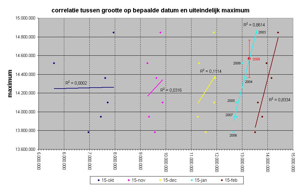
In de grafiek hieronder zie je een spreidingsgrafiek met op de x-as de grootte van het ijs in oktober, november, december, januari en februari van de afgelopen zes jaar, en op de y-as het uiteindelijke maximum in dat jaar. Door die punten heen zijn trendlijnen getrokken. Des te dichter de punten bij de lijn liggen, des te makkelijker is te voorspellen wat een bepaald maximum gaat worden, als je weet hoe groot het ijs op de eerdere datum is. De R2 waarde zegt iets over de verklarende kracht van de trendlijn, op een schaal van 0 (geen enkele zekerheid) tot 1 (volledige zekerheid).
Je ziet dat de zekerheid voor oktober bijzonder laag is - de punten liggen zeer ver van de trendlijn vandaan. In januari daarentegen zie je de hoogste zekerheid, de punten liggen zeer dicht bij de lijn. De zekerheid in januari is zelfs nog hoger dan in februari. Ik vermoed dat de reden is, dat de tijd tussen februari en het maximum zo kort wordt, dat onvoorspelbare weersinvloeden een grotere invloed krijgen.
Op basis van deze correlatie en de grootte op 15 januari, zou het maximum in maart uit moeten komen op iets minder dan 14,6 miljoen vierkante kilometer (rode punt), en gezien de afwijking van de trend van de andere datapunten schat ik de onzekerheidsmarge op +/- 200.000 vierkante kilometer (rode haakjes). Dat is gebaseerd op slechts 6 datapunten, dus zo heel zeker ben ik daar niet van. Maar dat het maximum onder de 14 miljoen of boven de 14,8 uitkomt, lijkt me onwaarschijnlijk. Daarmee zou 2009 (net als het gemiddelde van heel 2008) boven 2005, 2006 en 2007 eindigen, en waarschijnlijk boven 2004. Dat het groter dan 2003 kan worden geloof ik niet. De vergelijking met 2008 is duidelijk too close to call.
quote:'Opwarming Antarctica begonnen'
UTRECHT - Sinds de jaren 50 is de temperatuur rond de Zuidpool, waar 90 procent van 's werelds ijs ligt, met 0,5 graden gestegen, blijkt uit verzamelde gegevens van satellieten en weerstations.
Twee dagen na het bericht over het desintegreren van een grote ijsplaat op het Antarctisch schiereiland komt een groep Amerikaanse wetenschappers met een overzicht van alle beschikbare meetgegevens van het zuidelijke continent.
In tegenstelling tot het door klimaatsceptici frequent geproclameerde kouder worden en aangroeien van Antarctica, laat de wetenschappelijke realiteit geen enkele ruimte meer voor ontkenning: Klimaatverandering heeft de Zuidpool bereikt. En zoals overal: sneller dan we verwachtten, stellen de onderzoekers.
Eric Steig
"Wat je continu hoort is dat Antarctica kouder wordt en dat is simpelweg niet het geval", zegt Eric Steig van de Universiteit van Washington in Seattle, hoofdauteur van de studie die vandaag in Nature wordt gepubliceerd.
De gemiddelde temperatuurstijging is sterk vergelijkbaar met het mondiale gemiddelde, vertelt Steig. Klimaatsceptici stelden in het verleden dat Antarctica kouder zou worden als bewijs dat de mondiale opwarming een mythe zou zijn.
De Amerikaanse onderzoeksgroep schrijft dat de gemeten Antarctische opwarming moeilijk te verklaren is zonder deze te koppelen aan de sterk toegenomen antropogene uitstoot van broeikasgassen, voornamelijk door grootschalig gebruik van fossiele brandstoffen.
West-Antarctische ijskap
Op het Britse onderzoeksstation Rothere, op het Antarctisch schiereiland, was het gisteren 2,6 graden boven nul. "Maar het gebied waar we de opwarming meten is veel groter dan alleen het schiereiland. Ook de gehele West-Antarctische ijskap warmt op", zeggen de Amerikanen. "En de gemiddelde oppervlaktetemperatuur van het hele continent neemt toe", meldt de studie.
"West-Antarctica zal uiteindelijk smelten als deze opwarming zo doorzet", zegt Drew Shindell, een medeauteur van het NASA Goddard Institute for Space Studies.
Groenlandse ijskap
Daarvoor zou volgens hem een gemiddelde temperatuurstijging van 3 graden voor nodig zijn. Ook de Groenlandse ijskap zou bij een dergelijke temperatuurstijging niet overleven.
Tezamen bevatten zij genoeg ijs voor een gemiddelde zeespiegelstijging van 14 meter. De ijsmassa op Oost-Antarctica bevat zelfs voldoende water om de zeespiegel wereldwijd met nog eens 50 meter te laten stijgen. Deze ijskap is echter minder kwetsbaar voor de huidige opwarming.
"Maar zelfs wanneer slechts een fractie van Groenland en West-Antarctica smelt kunnen we deze eeuw nog meters zeespiegelstijging zien, met desastreuze gevolgen" target="_blank", zegt Barry Brook, directeur van het onderzoeksprogramma naar klimaatverandering van de Universiteit van Adelaide.
quote:Antarctica is warming up
The continent of Antarctica is warming up in step with the rest of the world, according to a new analysis.
Scientists say data from satellites and weather stations indicate a warming of about 0.6C over the last 50 years.
Writing in the journal Nature, they say the trend is "difficult to explain" without the effect of rising greenhouse gas levels in the atmosphere.
Meanwhile, scientists in Antarctica say a major ice shelf is about to break away from the continent.
The Wilkins Ice Shelf is said to be "hanging by a thread" from the Antarctic Peninsula, the strip of land pointing from the white continent towards the southern tip of South America.
In isolation
Most of Antarctica's scientific stations are located along the peninsula, and scientists have known for many years that this portion of the continent is getting warmer
But trends across the bulk of the continent have been much harder to discern, mainly because data from land stations is scarce.
It is somewhat insulated from the rest of the world's weather systems by winds and ocean currents that circulate around the perimeter.
In the new analysis, a team of US scientists combined data from land stations with satellite readings
"We have at least 25 years of data from satellites, and satellites have the huge advantage that they can see the whole continent," said Eric Steig from the University of Washington in Seattle.
"But the [land] stations have the advantage that they go back much further in time.
"So we combined the two; and what we found, in a nutshell, is that there is warming across the whole continent, it's stronger in winter and spring but it is there in all seasons."
They conclude that the eastern region of the continent, which is larger and colder than the western portion, is warming at 0.1C per decade, and the west at 0.17C per decade - faster than the global average.
Ik kon dit topic al niet meer vinden in mij actieve topics.
Nog een "treurige " bericht
Nog een "treurige " bericht
quote:Kolossale ijsplaat Zuidpool verdwijnt in zee
UTRECHT - De Wilkinsplaat, een reusachtige Antarctische ijsplaat, staat op het punt te desintegreren en in zee te stromen, zeggen Britse en Nederlandse onderzoekers.
.....

Auw, een paar meter zeespiegelstijging deze eeuw zou effectief het einde van Nederland betekenen. Tot 2 meter stijging is het met een hoop geld nog wel te doen, daarna wordt het technisch erg lastig....quote:
"It's hard to argue against cynics - they always sound smarter than optimists because they have so much evidence on their side."
Wat ze gedaan hebben is van meetstations met onderbroken dataseries, onzekere kwaliteit, en een slechte geografische dekking een correlatie gezocht met satelliet-data, en satelliet-data "gemodeleerd" voor de periode en de locatie waar tot dan toe geen data van was.quote:
Even voor het beeld: stel je voor dat ik onvolledige temperatuurseries had van de kust van Scandinavie en Siberie, en dat ik op basis van de correlatie tussen die series en bekende satellietgegevens een voorspelling zou doen van de temperaturen in Eurazië in het pre-satelliet tijdperk. Hoe veel waarde zou je er aan hechten als ik vervolgens uitspraken zou doen over temperatuurtrends van tienden van graden in die periode op die plaats?
bronquote:The researchers used satellite data and mathematical formulas to fill in missing information. That made outside scientists queasy about making large conclusions with such sparse information.
"This looks like a pretty good analysis, but I have to say I remain somewhat skeptical," Kevin Trenberth, climate analysis chief at the National Center for Atmospheric Research, said in an e-mail. "It is hard to make data where none exist."
Trenberth is ook hoofd auteur van het meest recente IPCC rapport, dus als het gaat om het creëren van data die niet bestaat is hij wel een kenner
(sorry, cheap shot, maar kon het niet laten)
Daarnaast gaan hun uitspraken louter over opwarming in de periode 1957-200X, terwijl de trendlijn vanaf 1979 (het beginpunt van de echte satellietdata) afkoelend is.
Matige studie die niets nieuws gevonden heeft. Enkele jaren geleden is nagegoeg dezelfde methode gebruikt om een vergelijkbaar onderzoek te doen, met vergelijkbare conclusies. zie hier.
Enige verschil is dat de auteurs van die studie wel eerlijk waren over de gevoeligheid voor de begindatum, en dat deze auteurs bewust een zo dramatisch mogelijk verhaal in het persbericht gestopt hebben, zonder enige nuance.
Tja, persberichten en wetenschap gaan sowieso al niet heel goed samen...
Als het gaat om data manipuleren zullen we het maar niet over sceptische 'wetenschappers' gaan hebben
Als het gaat om data manipuleren zullen we het maar niet over sceptische 'wetenschappers' gaan hebben
"It's hard to argue against cynics - they always sound smarter than optimists because they have so much evidence on their side."

Buitenhof had zondag een speciale uitzending over de polen.
Terugkijken & meer info:
http://www.vpro.nl/programma/buitenhof/afleveringen/40824225/
Wel een aanrader.
[ Bericht 36% gewijzigd door Toad op 26-01-2009 01:46:19 ]
Terugkijken & meer info:
http://www.vpro.nl/programma/buitenhof/afleveringen/40824225/
Wel een aanrader.
[ Bericht 36% gewijzigd door Toad op 26-01-2009 01:46:19 ]
In oktober was ik in Canada. Een van de dagen ben ik langs de Colombian icefields geweest, een grote eeuwige gletscher die al eeuwen aan het krimpen is. Vanaf 1800 word bijgehouden hoeveel hij gekrompen was. Opvallend was, dat die rond 1900 het hardste aan het krimpen was, en de laatste 7 jaar maar een klein stukje gekrompen was.
Don't pray for easy lifes, pray to be a stronger person.
De versnelling in stroomsnelheid van gletsjers op Groenland is ook abrupt ten einde gekomen, afgelopen jaar:
bron: Science (abbo nodig)quote:So much for Greenland ice's Armageddon. "It has come to an end," glaciologist Tavi Murray of Swansea University in the United Kingdom said during a session at the meeting. "There seems to have been a synchronous switch-off" of the speed-up, she said. Nearly everywhere around southeast Greenland, outlet glacier flows have returned to the levels of 2000. An increasingly warmer climate will no doubt eat away at the Greenland ice sheet for centuries, glaciologists say, but no one should be extrapolating the ice’s recent wild behavior into the future.
update van het zee-ijs:
In de sheet van de afgelopen paar maanden zat een klein foutje. Het NSIDC waar ik de data vandaan haal mist gegevens over december 1987 en januari 1988 (gevolg van de ramp met de Challenger, geloof ik). Een tijdje terug heb ik de sheet wat aangepast om nieuwe gegevens makkelijker toe te voegen, en toen ben ik vergeten om bij de berekening van de normaal van januari en december een maand minder te tellen. De normaal voor die maanden was dus wat lager dan hij had moeten zijn, waardoor er in de "afwijking van de normaal"-grafiek te veel ijs leek te liggen in alle december en januari maanden. Dat is nu dus opgelost. Omdat dezelfde fout in alle jaren zat, heeft dit voor de vergelijking tussen het ene en het andere jaar geen gevolgen, noch voor trendlijnen.
Dan naar januari:
de afwijking van de normaal is in januari marginaal kleiner dan in december, maar nog steeds flink negatief, -0,76 miljoen vierkante kilometer. De kleinste januari tot nu toe was 2006 (-1,24), sindsdien is de oppervlakte iedere januari weer iets gegroeid ten opzichte van de vorige. De lineaire trendlijn blijft gelijk op -0,5 miljoen vierkante kilometer per decennium.
Ondanks de bevindingen van Steig et al dat de Zuidpool al decennia hard aan het opwarmen is, zit deze nagenoeg even veel boven de normaal, wat de Noordpool er onder zit: +0,75 miljoen vierkante kilometer. Trendlijn blijft +0,13 miljoen vierkante kilometer per decennium.
Logisch gevolg van bovenstaande is dat de wereld als geheel een praktisch normaal oppervlakte had in januari.
quote:Kolossale ijsplaat Zuidpool verdwijnt in zee
UTRECHT - De Wilkinsplaat, een reusachtige Antarctische ijsplaat, staat op het punt te desintegreren en in zee te stromen, zeggen Britse en Nederlandse onderzoekers.
De ijsplaat heeft een oppervlak van duizenden vierkante kilometers en steekt als een platte berg 20 meter boven zeeniveau uit. Op satellietbeelden is te zien dat de plaat inmiddels vol grote scheuren zit en enkel nog wordt bijeengehouden door een steeds smallere strook zee-ijs.
Deze 40 kilometer lange ijsdam, die 'als een kurk op een fles' de rest van de gebarsten ijsplaat fixeert, was in 1950 nog 100 kilometer breed. Inmiddels rest volgens de British Antarctic Survey (BAS) niet meer dan een ‘splinter’ stabiel ijs, slechts 500 meter breed. Zodra deze doorbroken wordt, zal ook de achterliggende massa in zee stromen, verwachten de onderzoekers.
Nederlands onderzoek
“Het kan nu elk moment gebeuren” zegt David Vaughan, een glacioloog van BAS. “We zijn hier getuige van de laatste momenten van de Wilkins-ijsplaat.” Om de bewegingen van het ijs te registreren heeft Vaughan een GPS-meter op de plaat gestationeerd. Deze verzamelt gegevens voor onderzoek van IMAO, het Instituut voor Atmosferisch en Marien Onderzoek van de Universiteit Utrecht.
“Deze ijsplaten zijn een soort gletsjers, die op hun plek worden gehouden door bijvoorbeeld eilandjes'', vertelt Michiel van den Broeke, van IMAO. “Het is zeer zorgwekkend dat ze nu zo snel verdwijnen.” Het afbreken van de beschermende ijsplaten kan er volgens Van den Broeke voor zorgen dat ook de achterliggende gletsjers sneller naar zee gaan stromen. Dit kan de zeespiegelstijging versterken.
Grote delen van de ijsplaat werden in maart vorig jaar, aan het einde van de Antarctische zomer, instabiel. In voorgaande jaren verdwenen al de 'Prince Gustav Channel', 'Larsen Inlet', 'Larsen A', 'Wordie', 'Muller' en de Jones-ijsplaat in zee. Het meest geruchtmakend was het instorten van ‘Larsen B’ in 2002. Deze omvangrijke ijsplaat verdween in 30 dagen volledig van de kaart. Uit sedimentonderzoek is gebleken dat de ijsplaten in elk geval meer dan 10.000 jaar oud waren.
Massaverlies
"Het verdwijnen van deze ijsplaat en de negen andere is een direct gevolg van klimaatverandering", zegt Vaughan. Het Antarctisch schiereiland is daar relatief gevoelig voor, omdat het ijs daar vrij ver in de omringende oceaan steekt. De gemiddelde temperatuur is er sinds 1950 al met drie graden gestegen. Maar ook de West-Antarctische ijskap verliest de laatste jaren massa, blijkt uit satellietmetingen. En in tegenstelling tot de populaire theorie dat hogere temperaturen het ijs op Antarctica zouden versterken met extra sneeuwval, blijkt ook de nog immer zeer koude Oost-Antarctische ijskap niet te groeien.
Vanwege de vele onzekerheden is in de officiële voorspellingen voor zeespiegelstijging van het IPCC tot nog toe echter geen rekening gehouden met een mogelijk versneld bewegen van gletsjers op Antarctica en Groenland. Het laatste grote klimaatrapport, uit 2007, gaat nog uit van een stijging van 18 tot 59 centimeter.
quote:Gletsjers Pyreneeën smelten snel
AMSTERDAM - De Pyreneeën hebben in de laatste eeuw bijna negentig procent van hun gletsjerijs verloren en het resterende ijs kan door de opwarming van de aarde binnen enkele decennia verdwenen zijn.
Dat zegt het Spaanse ministerie van milieu.
Het ministerie liet onderzoek doen naar de gevolgen van de opwarming van de aarde voor de Pyreneeën
3300 hectare
De onderzoekers constateerden dat van de 3300 hectare ijs die in het begin van de twintigste eeuw het gebergte bedekte nog maar 390 hectare over is. Het restant is ongeveer gelijk verdeeld tussen Frankrijk en Spanje.
Daarbij komt dat het overgebleven ijs steeds sneller smelt. Tussen 2002 en 2008 verloren de Spaanse Pyreneeën ongeveer een kwart van hun gletsjerijs, aldus het vorige week vrijgegeven onderzoeksrapport.
Broeikaseffect
De onderzoekers leggen een rechtstreeks verband tussen het smelten van de gletsjers in de Pyreneeën en andere gebergten, de opwarming van de aarde en veranderingen in neerslagpatronen.
De Spaanse voorzitter van de organisatie voor behoud van gletsjers in de Pyreneeën, Fernando Lampre, zegt in een interview in de krant El Pais te vrezen dat de meeste gletsjers over 25 tot dertig jaar zijn verdwenen.
"En tegen het midden van de eeuw zijn ze allemaal weg", aldus Lampre.
VN
Volgens het Milieuprogramma van de Verenigde Naties worden gletsjers in de hele wereld bedreigd. De website van de VN-organisatie zegt te hopen dat de Klimaatconferentie van eind 2009 in Kopenhagen voor een doorbraak zal zorgen. Zo niet, dan 'is het mogelijk dat gletsjers in de 21ste eeuw volledig uit veel bergketens verdwijnen'.
quote:Wetenschappers constateren drastische smelting
Uitgegeven: 26 februari 2009 11:53
Laatst gewijzigd: 26 februari 2009 11:53
UTRECHT - Het Arctische én Antarctische gebied warmen sneller op dan gedacht, met een steeds grotere kans op drastische klimaatverandering, zegt een groep internationale klimaatexperts.
Ze zijn onderdeel van een groot onderzoeksprogramma van de VN in beide poolregio’s, dat twee jaar geleden is begonnen.
De resultaten verscherpen reeds bekende trends op basis van satellietmetingen sinds het einde van de jaren ’70.
“Sneeuw en ijs trekken zich rond beide polen terug, waardoor niet alleen mensen en natuur binnen de poolcirkels worden beïnvloed, maar ook grote mondiale processen, zoals de atmosferische koolstofkringloop en zeespiegelstijging", luidt de samenvatting van het in het kader van het International Polar Year (IPY) gepresenteerde rapport.
IJsmassa
Het rapport, onder de titel 'State of Polar Research', moet een overzicht geven van alle beschikbare wetenschappelijke kennis.
"De resultaten worden nog verder verfijnd, maar het is inmiddels zeker dat zowel Groenland als Antarctica ijsmassa verliezen en dus zeespiegelstijging veroorzaken, en dat de smelt op Groenland bovendien versnelt", aldus de onderzoeksgroep, waar 10.000 wetenschappers en 63 landen in participeren.
Weersveranderingen
De poolexperts melden bovendien een versnelde opwarming te zien op het westelijk deel van Antarctica, een gebied dat eerder stabiel werd geacht.
"Je kunt rekenen op dramatische weersveranderingen in bijvoorbeeld Chili en Argentinië”, zegt Ian Allison, vice-voorzitter van het IPY-bestuur.
Het pooljaar wordt georganiseerd door de onafhankelijke Internationale Wetenschapsraad (ICS), in samenwerking met de World Meteorological Organization en het IPCC.
Klimaattop
Internationale politici, die in december tijdens de klimaattop in Kopenhagen overeenstemming moeten bereiken over het nieuwe klimaatverdrag, laten zich deze week op de meetstations op Antarctica informeren over de staat van het onderzoek.
Winnaar Agnes Kant knuffel 2010.
Indeed, what are the roots of western geometry? Nothing else but the Egyptian techniques of surveying property.
Indeed, what are the roots of western geometry? Nothing else but the Egyptian techniques of surveying property.
waar is dit in hemelsnaam op gebaseerd? De temperaturen op zowel de Noord- als de Zuidpool zijn de afgelopen 2-3 jaar koeler geweest dan daarvoor. Zeeijs op de Zuidpool is groter dan ooit gemeten, op de Noordpool is er een (zeer klein) herstel na het dieptepunt in 2007. Gletsjers op Groenland zijn na een rush eerder dit decennium in het laatste jaar nagenoeg tot stilstand gekomen.
Baseren ze zich op data tot en met 2005/2006? Gebruiken ze andere meetgegevens dan die publiekelijk beschikbaar zijn? Echt onbegrijpelijk
Baseren ze zich op data tot en met 2005/2006? Gebruiken ze andere meetgegevens dan die publiekelijk beschikbaar zijn? Echt onbegrijpelijk
quote:Echt onbegrijpelijk
Oops. We overlooked 193,000 square miles of ice
19 Feb 09 – The ice is melting! The ice is melting! . . . Or is it?
quote:In May, 2008, the National Snow and Ice Data Center (NSIDC) predicted that the North Pole would be ice-free during the 2008 melt season because of ‘global warming.’
Today, they admitted that they’ve underreported Arctic ice extent by 193,000 square miles (500,000 square kilometers). They blamed the error on satellite problems and sensor drift.
And we’re supposed to trust these people?
193,000 square miles!
That’s the size of Maine, Vermont, Maryland, Massachusetts, New
York, New Hampshire, Pennsylvania, New Jersey, Rhode Island,
and West Virginia combined! And toss in Washington, D.C. for
good measure.
Let’s watch the newspapers. If a pimple of ice smaller than a city
should break off an ice sheet, they'd holler to the high heavens.
But do you think they’ll report this discovery of 'lost' ice the size
of 10 states?
http://www.iceagenow.com/(...)are_miles_of_ice.htm
nou ja, dat die sensor stuk gaat kunnen ze ook weinig aan doen natuurlijk, al vind ik wel dat hun eerste reactie (move along, nothing to see here) nogal matig was. Maar je moet het probleem ook niet overdrijven. De problemen zijn in december (heel klein) begonnen, en pas in februari werden ze dermate groot dat zelfs een leek ze kon zien. Maar het verband met de voorspelling van mei is nogal suggestief, aangezien er toen nog geen problemen met de sensor waren. (wat niet wegneemt dat de voorspelling zelf ook nogal suggestief was en ook niet is uitgekomen - een feit dat minder in het nieuws is geweest dan de voorspelling zelf).
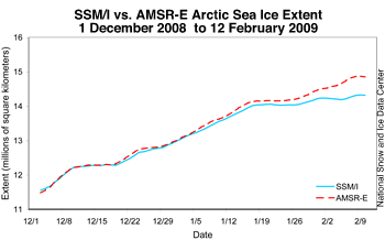
onderstaande grafiek zie je een vergelijk tussen de defecte SSM/I sensor die het NSIDC gebruikt, en de AMSR-E sensor die door o.a. IARC-JAXA gebruikt wordt. Tot dik in januari is het verschil miniem, pas in februari loopt het heel hard op.
onderstaande grafiek zie je een vergelijk tussen de defecte SSM/I sensor die het NSIDC gebruikt, en de AMSR-E sensor die door o.a. IARC-JAXA gebruikt wordt. Tot dik in januari is het verschil miniem, pas in februari loopt het heel hard op.
quote:Op vrijdag 27 februari 2009 14:36 schreef francorex het volgende:
In May, 2008, the National Snow and Ice Data Center (NSIDC) predicted that the North Pole would be ice-free during the 2008 melt season because of ‘global warming.’
Bron?
Ach, laat ook maar...
kies maar uit:quote:
http://www.google.com/search?source=ig&hl=nl&rlz=&q=serreze+ice-free+pole&meta=lr%3D
oh wacht, je zei "laat ook maar". Blijkbaar had je zelf ook door dat je
edit: okok, Serezze zei "may be", niet "will be", dat is waar, dus dan hoef je daar alvast niet over te zeuren
[ Bericht 6% gewijzigd door Ared op 28-02-2009 15:13:40 ]
Het maximum valt de afgelopen jaren eigenlijk altijd in de week tussen 8 en 15 maart, dus over twee weken zouden we moeten weten waar 2009 gaat eindigen in de ranglijst van jaren met kleinste extent. Hier dan maar weer even een update. De groei is dit jaar iets grilliger dan in 2008 en 2004 (de directe concurrentie qua grootte). Vorige week kromp de pool opeens zo snel, dat het even de vraag was of we het maximum al gehad hadden, maar de afgelopen dagen is het ijs weer flink uitgebreid, en groter dan voor de dip. Voor de duidelijkheid: dit is gebaseerd op de AMSR-E sensor waar geen problemen mee geweest zijn.
Kijken we naar de correlatie tussen 27 februari en het maximum, dan zien we dat de trendlijn een zeer grote verklarende kracht (R2) van 0,99 heeft. Dat wil zeggen dat we een behoorlijk nauwkeurige voorspelling kunnen doen van hoe groot het ijs nog gaat worden. Aangezien de extent nu al groter is dan het maximum van 2005, 2006 en 2007, blijft de top3 kleinste maxima ongewijzigd. De strijd gaat tussen 2004 en 2009, met 2008 redelijk veilig boven het 95% confidence interval. Overigens is dit een versimplificeerde zekerheidsberekening (ik zal jullie niet vervelen met details), dus hij klopt niet helemaal, maar het verschil is denk ik verwaarloosbaar klein op dit punt. Als er al verschil is, zal mijn berekening te ruim zijn, waarmee het zeker lijkt dat 2009 op plaats 4 of 5 terecht gaat komen.
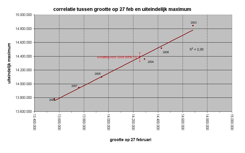
Aangezien een maximum niet meer kleiner kan worden als er al een bepaalde waarde is gehaald, zou het binnen enkele dagen al zeker kunnen zijn of 2004 geklopt wordt of niet - daar is nog 107.000 vierkante kilomter voor nodig, en de groei de laatste vier dagen is meer dan 50.000 vierkante kilometer per dag.
Kijken we naar de correlatie tussen 27 februari en het maximum, dan zien we dat de trendlijn een zeer grote verklarende kracht (R2) van 0,99 heeft. Dat wil zeggen dat we een behoorlijk nauwkeurige voorspelling kunnen doen van hoe groot het ijs nog gaat worden. Aangezien de extent nu al groter is dan het maximum van 2005, 2006 en 2007, blijft de top3 kleinste maxima ongewijzigd. De strijd gaat tussen 2004 en 2009, met 2008 redelijk veilig boven het 95% confidence interval. Overigens is dit een versimplificeerde zekerheidsberekening (ik zal jullie niet vervelen met details), dus hij klopt niet helemaal, maar het verschil is denk ik verwaarloosbaar klein op dit punt. Als er al verschil is, zal mijn berekening te ruim zijn, waarmee het zeker lijkt dat 2009 op plaats 4 of 5 terecht gaat komen.
Aangezien een maximum niet meer kleiner kan worden als er al een bepaalde waarde is gehaald, zou het binnen enkele dagen al zeker kunnen zijn of 2004 geklopt wordt of niet - daar is nog 107.000 vierkante kilomter voor nodig, en de groei de laatste vier dagen is meer dan 50.000 vierkante kilometer per dag.

Jaja, "zeuren"...quote:Op zaterdag 28 februari 2009 15:03 schreef Ared het volgende:
[..]
kies maar uit:
http://www.google.com/search?source=ig&hl=nl&rlz=&q=serreze+ice-free+pole&meta=lr%3D
oh wacht, je zei "laat ook maar". Blijkbaar had je zelf ook door dat jesmiley op jezelf sloeg...
edit: okok, Serezze zei "may be", niet "will be", dat is waar, dus dan hoef je daar alvast niet over te zeuren
Laat ik voor de grap eens citeren wat er staat: "at the geographic North Pole". Dat is vanzelfsprekend heel wat anders dan wat er gesuggereerd wordt.
Beweerde iemand iets anders dan? Het door francorex geciteerde artikel beweert precies hetzelfde als de schreeuwende koppen boven het interview met Serreze: een ijsvrije Noordpool.quote:Op zondag 1 maart 2009 12:52 schreef Monidique het volgende:
Jaja, "zeuren"...
Laat ik voor de grap eens citeren wat er staat: "at the geographic North Pole". Dat is vanzelfsprekend heel wat anders dan wat er gesuggereerd wordt.!
!
De meeste copy-paste media hebben ook niet eens de moeite genomen om te vermelden dat het alleen om een paar vierkante kilometer bij de geografische pool gaat:
http://www.nu.nl/wetensch(...)n-het-verschiet.html
zelfs het KNMI heeft die moeite (in augustus, toen al duidelijk werd dat het waarschijnlijk niet ging gebeuren) niet genomen om onderscheid te maken tussen de noordpool als geheel en de geografische noordpool als punt:
http://www.knmi.nl/VinkCMS/news_detail.jsp?id=42783
kennislink blijkt ook suggestielink te zijn:
http://www.kennislink.nl/web/show?id=209338
Nou zijn dit Nederlandse voorbeelden, maar ik kan me ook niet herinneren dat Serreze of het NSIDC erg hun best hebben gedaan om het beeld dat het om al het ijs ging te nuanceren.
Maar dat het indertijd alleen om de plek van geografische pool ging was duidelijk bij het lezen van de engelstalige artikelen, Mij toen in elk geval wel, Als het hele noordpoolgebied was bedoeld zou niet de term "the northpole" zijn gebruikt, maar "the arctic". De klakkeloze vertalingen waren tenenkrommend.quote:Op maandag 2 maart 2009 11:21 schreef Ared het volgende:
[..]
Beweerde iemand iets anders dan? Het door francorex geciteerde artikel beweert precies hetzelfde als de schreeuwende koppen boven het interview met Serreze: een ijsvrije Noordpool.
De meeste copy-paste media hebben ook niet eens de moeite genomen om te vermelden dat het alleen om een paar vierkante kilometer bij de geografische pool gaat:
http://www.nu.nl/wetensch(...)n-het-verschiet.html
zelfs het KNMI heeft die moeite (in augustus, toen al duidelijk werd dat het waarschijnlijk niet ging gebeuren) niet genomen om onderscheid te maken tussen de noordpool als geheel en de geografische noordpool als punt:
http://www.knmi.nl/VinkCMS/news_detail.jsp?id=42783
kennislink blijkt ook suggestielink te zijn:
http://www.kennislink.nl/web/show?id=209338
Nou zijn dit Nederlandse voorbeelden, maar ik kan me ook niet herinneren dat Serreze of het NSIDC erg hun best hebben gedaan om het beeld dat het om al het ijs ging te nuanceren.
"the northpole" moet altijd gelezen worden als dat kleine gebied rond de geografische noorpool en niet zomaar als "de Noordpool" vertaald worden, en dat gebeurde toen wel.
Huidige trend atmosf. CO2 Mauna Loa: 411 ppm ,10 jaar geleden: 387 ppm , 25 jaar geleden: 358 ppm
Ja, toen ik het bericht op Nu.nl zag ben ik ook meteen gaan zoeken waar ze die voorspelling in hemelsnaam vandaan gehaald hebben, aangezien in de Sea Ice Outlook van mei, geen enkel van de 19 teams internationale weteenschappers een extent van 0 voorspelde. Toen vond ik ook wel vrij snel dat Serreze het alleen over de geografische Noordpool had gehad.
Ik vraag me wel af of Serreze dan echt zo naïef is, dat hij niet heeft geweten welke suggestie hij zou wekken toen hij tegen journalisten zei dat de Noordpool wel eens ijsvrij zou kunnen zijn in de zomer van 2008?
Maar misschien heb je gelijk dat North Pole altijd vertaald moet worden als de geografische Noordpool en niet als het hele gebied, maar dan is Monidique's kritiek dat het gebruik van "North Pole" suggestief is, ook niet juist. Dan hebben alle Engelstaligen in ieder geval het juiste woord in de juiste situatie gebruikt, en is de toevoeging geographic slechts een pleonasme.
Precies, het zou een pleonasme zijn.quote:Op maandag 2 maart 2009 13:02 schreef Ared het volgende:
Ja, toen ik het bericht op Nu.nl zag ben ik ook meteen gaan zoeken waar ze die voorspelling in hemelsnaam vandaan gehaald hebben, aangezien in de Sea Ice Outlook van mei, geen enkel van de 19 teams internationale weteenschappers een extent van 0 voorspelde. Toen vond ik ook wel vrij snel dat Serreze het alleen over de geografische Noordpool had gehad.
Ik vraag me wel af of Serreze dan echt zo naïef is, dat hij niet heeft geweten welke suggestie hij zou wekken toen hij tegen journalisten zei dat de Noordpool wel eens ijsvrij zou kunnen zijn in de zomer van 2008?
Maar misschien heb je gelijk dat North Pole altijd vertaald moet worden als de geografische Noordpool en niet als het hele gebied, maar dan is Monidique's kritiek dat het gebruik van "North Pole" suggestief is, ook niet juist. Dan hebben alle Engelstaligen in ieder geval het juiste woord in de juiste situatie gebruikt, en is de toevoeging geographic slechts een pleonasme.
hier maakte ik al een opmerking erover toen iedereen met dat nieuwsbericht aan de haal ging.
Waar Sereze het toen over had was dat op de (geografische) Noordpool alleen nog eenjarig ijs lag, dat het meerjarig ijs door drift van die plaats verdwenen was, en dat er een kans was op de unieke situatie dat de Noordpool zelf een korte tijd per schip bereikbaar zou worden. Natuurlijk veel te speculatief, maar hij heeft het toen zeker niet over "the arctic" gehad.
[ Bericht 0% gewijzigd door barthol op 02-03-2009 14:32:01 ]
Huidige trend atmosf. CO2 Mauna Loa: 411 ppm ,10 jaar geleden: 387 ppm , 25 jaar geleden: 358 ppm
en sinds vandaag (nou ja, eigenlijk gister dus - de data loopt een dag achter) is de extent van de Noordpool inderdaad groter dan het maximum van 2004. In 2004 was het maximum 14,36 miljoen vierkante kilometer, dit jaar staat de teller op 14,37 met nog ruim een week te gaan waarin groei mogelijk is.quote:Op zaterdag 28 februari 2009 16:20 schreef Ared het volgende:
Aangezien een maximum niet meer kleiner kan worden als er al een bepaalde waarde is gehaald, zou het binnen enkele dagen al zeker kunnen zijn of 2004 geklopt wordt of niet - daar is nog 107.000 vierkante kilomter voor nodig, en de groei de laatste vier dagen is meer dan 50.000 vierkante kilometer per dag.
Mijn kritiek is, zoals vrijwel altijd, volledig juist: er staat dat de voorspelling was dat de noordpool ijsvrij zou zijn door het opwarmen van de aarde. Echter blijkt het te gaan om een wetenschapper die de kans mogelijk achtte dat de geografische noordpool tijdelijk ijsvrij zou zijn de afgelopen zomer. Nou, het lijkt mij al heel duidelijk dat de suggestie van het artikel niet was: 'o, we bedoelen de geografische noordpool!' Weinig verrassend, immers: een "skeptische" website, maar toch: er is praktisch gezien gelogen, en sowieso misleid. Sja.
En dan begin jij over zeuren en hoe smilies op mij slaan. Hoe fout kun je zitten...
En dan begin jij over zeuren en hoe smilies op mij slaan. Hoe fout kun je zitten...
dus je bent het niet met Barthol eens dat "North Pole" letterlijk vertaald de geografische noordpool is?
in dat geval zijn de koppen van de nieuwsberichten waarin de voorspelling van Serreze gebracht wordt minstens net zo misleidend als het door francorex geciteerde stukje.
of je bent het wel met Barthol eens, maar in dat geval is het stukje alleen misleidend omdat er onterecht een verband tussen de voorspelling en de defecte sensor gelegd wordt, wat ik zelf ook al aangaf.
ik heb je in ieder geval nog niet gehoord over de feitelijke onjuistheden in de stukjes van nu.nl, het KNMI en Kennislink. Mag ik aannemen dat je het met me eens bent dat ook hier "praktisch gezien gelogen, en sowieso misleid" is?
Zozo, toe maar.quote:Op maandag 2 maart 2009 20:35 schreef Ared het volgende:
ik heb je in ieder geval nog niet gehoord over de feitelijke onjuistheden in de stukjes van nu.nl, het KNMI en Kennislink.
Je mag aannemen wat je wilt. Overigens, als antwoord: nee.quote:Mag ik aannemen dat je het met me eens bent dat ook hier "praktisch gezien gelogen, en sowieso misleid" is?
wil je dat ook uitleggen?
wat er staat is namelijk pertinent onjuist.
"Het is mogelijk dat er al deze zomer voor het eerst sinds heugenis enige tijd geen ijs op de Noordpool is. " (nu.nl)
"Mogelijk is de noordpool eind deze zomer ijsvrij." (KNMI)
"De noordpool is eind deze zomer misschien ijsvrij. " (Kennislink)
Misschien dat in het Engels met North Pole alleen de geografische pool bedoeld wordt, maar in het Nederlands kun je echt niet beweren dat die stukjes duidelijk alleen over de geografische pool gaan.
Maar misschien wil je nog even antwoord geven op de vraag hoe jij denkt dat "North Pole" vertaald moet worden?
Even een kick want rond deze tijd begint toch de smeltperiode weer?
Ik ben zeer benieuwd hoe dat verloopt. Iemand overigens een goede website die in de gaten houdt hoe het met de ijsberen gaat?
Ik ben zeer benieuwd hoe dat verloopt. Iemand overigens een goede website die in de gaten houdt hoe het met de ijsberen gaat?
Nee.quote:Op dinsdag 3 maart 2009 10:23 schreef Ared het volgende:
wil je dat ook uitleggen?
wat er staat is namelijk pertinent onjuist.
"Het is mogelijk dat er al deze zomer voor het eerst sinds heugenis enige tijd geen ijs op de Noordpool is. " (nu.nl)
"Mogelijk is de noordpool eind deze zomer ijsvrij." (KNMI)
"De noordpool is eind deze zomer misschien ijsvrij. " (Kennislink)
Misschien dat in het Engels met North Pole alleen de geografische pool bedoeld wordt, maar in het Nederlands kun je echt niet beweren dat die stukjes duidelijk alleen over de geografische pool gaan.
Maar misschien wil je nog even antwoord geven op de vraag hoe jij denkt dat "North Pole" vertaald moet worden?
quote:Melting glaciers may redraw borders
ROME, Italy (CNN) -- Melting glaciers in the Alps may prompt Italy and Switzerland to redraw their borders near the Matterhorn, according to parliamentary draft legislation being readied in Rome
Franco Narducci of Italy's opposition Democratic Party is preparing a bill to redefine the frontier with neighboring Switzerland, his office said Wednesday.
Narducci is a member of the foreign affairs panel in Italy's lower Chamber of Deputies. Foreign Minister Franco Frattini has authorized the bill.
Switzerland also has cooperated with Italy on the matter.
The Italian Military Geographic Institute says climate change is responsible for the Alpine glaciers melting.
"This draft law is born out the necessity to revise and verify the frontiers given the changes in climate and atmosphere," Narducci said. "The 1941 convention between Italy and Switzerland established as criteria [for border revisions] the ridge [crest] of the glaciers. Following the withdrawal of the glaciers in the Alps, a new criterion has been proposed so that the new border coincides with the rock."
The border change only affects uninhabited mountaintop terrain. The deputy excludes the possibility of any family having to change citizenship.
The border between Italy and Switzerland was fixed 1861, when Italy became a nation, but it has been occasionally modified, the Military Geographic Institute said. The border was last modified in the 1970s when the Switzerland-Italy highway was built at the Brogeda crossing.
The bill is expected to become law by the end of April, Narducci said.
Maximum is gehaald op 5 maart (14,4 miljoen vierkante kilometer), maar het echte smelten is nog niet begonnen. Stand is nu zo'n 14,2 miljoen vierkante kilometer, ongeveer gelijk met 2008, maar nog steeds hoger dan het maximum van bijvoorbeeld 2005 (14,1), 2006 (13,8) en 2007 (13,9).quote:Op woensdag 25 maart 2009 02:09 schreef Toad het volgende:
Even een kick want rond deze tijd begint toch de smeltperiode weer?
Ik ben zeer benieuwd hoe dat verloopt.
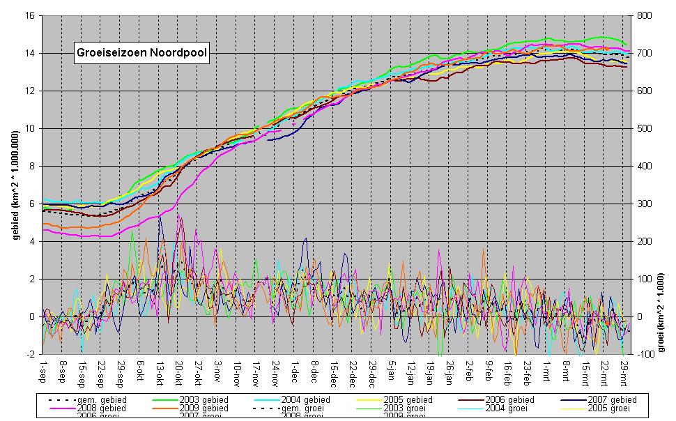
ik heb heel even gekeken, maar het is lastig om quantitatieve data te vinden. Het meeste is retoriek al dan niet gekoppeld aan voorspellingen.quote:Iemand overigens een goede website die in de gaten houdt hoe het met de ijsberen gaat?
op deze pagina (http://www.polarbearsinternational.org/ask-the-experts/population/) staat wel een redelijke samenvatting met goede punten, hoewel ik het einde weer zwak vind. IJsberen hebben al een interglaciaal meegemaakt dat warmer was dan het huidige, zonder uit te sterven - al waren er toen natuurlijk nog geen mensen die ze neerschoten als ze hongerig door onze straten liepen.
Per locatie en populatie kan het dus verschillend gaan met de ijsberen, en als de populatie terugloopt kan dat ook meerdere oorzaken hebben (verdwijnen van ijs in de Hudson Baai, door jacht in de Baffin Baai en Kane Basin etc.)quote:At this point, we lack quantitative data for an overall assessment of trend in Canada or Nunavut as a whole. There is, however, very strong evidence for a decline in Western Hudson Bay and the Southern Beaufort Sea based on quantitative studies. More recently, scientists working in the Southern Hudson Bay have reported a major decline in the condition of polar bears. A decline in condition was the precursor to the population decline in Western Hudson Bay. There is clear suggestion of a population decline due to over-harvest in Baffin Bay, Kane Basin and possibly Norwegian Bay.
The point is that you cannot simply summarize the status of polar bears—the information lies in the individual populations. You cannot put the various time periods together into a simplistic overview. Sea ice is declining but again, it is not declining the same everywhere. Some small areas of multi-year ice may improve habitat for polar bears. This latter point, however, does not mean that the habitat in all areas will improve and the predictions are very clear that the primary habitat of polar bears is at risk.


Duikboot breekt door poolijs
De foto's mogen dan wel spectaculair zijn, maar toch heeft het ook iets alarmerends: een atoomduikboot van de Amerikaanse marine is door een meter dikke ijslaag aan de Noordpool gebroken. Deze (letterlijke en figuurlijke) doorbraak is vooral angstwekkend omdat de ontginning van de ongerepte Noordpool hierdoor kan versneld worden. Onder meer de Russen en de Amerikanen voeren een 'Koude Oorlog' om de vele olie- en gasvelden aan de Noordpool.

ICEX
In een maagdelijk wit landschap is de Amerikaanse atoomonderzeeër USS Annapolis dit weekend door een een meter dikke ijslaag gebroken. De spectaculaire foto¿s werden pas nu vrijgegeven door de Amerikaanse marine. De onderzeeër uit de Los Angeles klasse maakt samen met een tweede duikboot deel uit van een militair-wetenschappelijke oefening, toepasselijk ICEX genoemd. De onderzeeër biedt plaats aan meer dan honderd personen. Daarnaast is ook een tweede duikboot USS Helena ingezet voor het onderzoek dat twee weken zal duren.

Unieke omgeving
Naast het militaire luik is er ook het wetenschappelijke. Onderzoekers van de universiteit van Washington sloegen op het poolijs hun tenten op. Met de oefening wil de marine ervaring opdoen in de unieke omgeving onder het ijs van de Noordpool. Critici denken dat de Verenigde Staten actiever worden in het gebied vanwege de hoeveelheden olie en gas die makkelijker toegankelijk worden als het ijs van de Noordpool smelt door de versnelde global warming. (hlnsydney/kh)
bron:hln

Echt idioot hoe ze (VS, Rusland etc.) met de Noordpool omgaan.
Thnx trouwens voor de ijsberensite. Ik was d'r ook al opgekomen. Het is vooral een Amerikaans/Canadees verhaal volgens mij.
Thnx trouwens voor de ijsberensite. Ik was d'r ook al opgekomen. Het is vooral een Amerikaans/Canadees verhaal volgens mij.
Breken amerikaanse en russische onderzeeërs niet al sinds de jaren 50 regelmatig door de dunne plekken op de Noordpool?
In 1986 en 1987 hebben ze er zelfs feestjes met drie subs van gemaakt (merk op hoeveel water er tussen het ijs te vinden is in 1987):
In 1986 en 1987 hebben ze er zelfs feestjes met drie subs van gemaakt (merk op hoeveel water er tussen het ijs te vinden is in 1987):


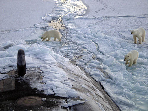
mooie foto's
Ik zit de laatste dagen steeds te kijken of dat uitstekende enorme stuk zeeijs voor de kust van New-Foundland op drift raakt.
Ik zit de laatste dagen steeds te kijken of dat uitstekende enorme stuk zeeijs voor de kust van New-Foundland op drift raakt.

Huidige trend atmosf. CO2 Mauna Loa: 411 ppm ,10 jaar geleden: 387 ppm , 25 jaar geleden: 358 ppm
http://www.nzz.ch/nachric(...)scnat_1.2307132.htmlquote:Die Gletscher in den Alpen schwinden weiter
Gornergletscher innert eines Jahres um 290 Meter geschrumpft
Die Schweizer Gletscher schmelzen rasch weiter, wie die neusten Daten zeigen. Dies hat die Schweizer Akademie der Naturwissenschaften (SCNAT) am Mittwoch mitgeteilt. Vom Herbst 2007 bis zum Herbst 2008 seien 82 der 88 untersuchten Gletscher kürzer geworden. Der Gornergletscher habe gar 290 Meter an Länge verloren.
(sda) Die jüngsten Messungen bestätigten den anhaltenden Rückgang der Gletscher in den vergangenen Jahren, schreibt die SCNAT in ihrer Mitteilung. Von 88 Gletschern, deren Daten ausgewertet wurden, blieben nur zwei unverändert, und vier wurden etwas länger. Die meisten Gletscher verloren zwischen 0 und 25 Metern Länge. Den Negativrekord hält der Walliser Gornergletscher, der sich innert eines Jahres um 290 Meter verkürzte. Zurückzuführen ist dies laut Communiqué auf ein Absinken bei der Gletscherzunge: Das Zungenende wurde vom Gletscher abgetrennt und ist nun bis auf kleine Reste zusammengeschmolzen.
Verzögerte Auswirkung
Die Änderung der Gletscherlänge folgt mit zeitlicher Verzögerung auf Ursachen wie Temperaturerwärmungen. Die Zu- oder Abnahme der Gletschermasse widerspiegelt die Witterung im Untersuchungszeitraum deutlicher und unmittelbarer. Dieser Massehaushalt wurde insgesamt an fünf Gletschern bestimmt; alle davon verloren im Untersuchungszeitraum an Masse. Insgesamt liege die Abnahme etwa im Rahmen der vergangenen zehn Jahre, sagte der Glaziologe Andreas Bauder von der ETH Zürich auf Anfrage. Die Werte am Pizol- und Silvrettagletscher sind weniger negativ, jene der Gletscher Basòdino, Gries und Rhone etwas negativer als das Zehnjahresmittel.
Warmer Mai und Juni 2008
Der Grund für die Gletscherschmelze 2007/08 sind laut dem Communiqué der SCNAT vor allem die überdurchschnittlich warmen Monate Mai und Juni im Jahr 2008. Sie sorgten dafür, dass der im Winter 2007/08 eigentlich reichlich gefallene Schnee auf den Gletschern rasch schmolz, so dass die Hitze des Sommers direkt das Gletschereis angreifen konnte.
Für den Winter 2008/09 gibt es laut Bauder noch keine Zahlen. Der Winter dauert nämlich für die Gletscher noch an: Weil es in den Bergen immer noch kalt ist und schneit, erreichen die Gletscher erst etwa Ende April oder Anfang Mai ihre grösste Ausdehnung und Masse.
Alpengletsjers verder geslonkenquote:De Zwitserse Alpengletsjers smelten in rap tempo. Volgens de meest recente gegevens zijn 82 van de 88 onderzochte gletsjers in een jaar tijd geslonken in omvang. Dat maakte de Zwitserse Academie voor Natuurwetenschappen (SCNAT) woensdagmiddag bekend.
De jongste metingen bevestigen de aanhoudende teruggang van gletsjers in de afgelopen jaren. Van de 88 onderzochte ijsmassa's bleven er twee onveranderd en werden er vier iets langer. Het merendeel van de gletsjers verloor tot 25 meter in lengte.
De ijstong die het zwaarst te lijden had, was de Walliser Gornergletsjer. Deze ijsmassa moest tussen herfst 2007 en herfst 2008 maar liefst 290 meter prijsgeven. De ongewoon warme maanden mei en juni vorig jaar zijn indirect de oorzaak van de afgenomen lengte. Doordat in die maanden de sneeuw zo snel smolt, kon de zomerwarmte meteen toeslaan.
Op zaterdag 15 augustus 2009 23:05 schreef eer-ik het volgende:
Ik vind je sig nogal denigrerend.
Ik vind je sig nogal denigrerend.
Zo dadelijk weer een stukje van de wilkinsplaat eraf.quote:125 Teletekst za 04 apr
***************************************
IJsschots Antarctica op afbreken
***************************************
` In het Zuidpoolgebied dreigt een
grote ijsschots af te breken van de
zogenoemde Wilkins-ijsplaat.De schots
zit nu nog met een smalle ijsbrug vast
aan het vasteland van Antarctica,maar
op satellietbeelden van de Europese
Ruimtevaart Organisatie ESA is te zien
dat die verbinding op knappen staat.
De ijschots is zeker 10.000 km2 groot,
een kwart van Nederland.Oorspronkelijk
was hij nog groter maar er is vorig
jaar twee keer een stuk van afgebroken.
Wetenschappers houden de Wilkinsplaat
al jaren scherp in de gaten.Voor hen
geldt de ijsplaat als barometer voor de
opwarming van de aarde.
http://www.esa.int/esaCP/SEMD07EH1TF_index_0.html (met plaatjes in het engels)
De NSIDC laat aan het begin van het smeltseizoen weer waarschuwende berichten horen over de dikte van het noordpoolijs. De kwetsbaarheid ervan omdat er veel eenjarig ijs is, ook 'wel wat' tweejarig ijs is maar het oudere meerjarige ijs heel weinig.
Sciencedaily: Arctic Literally On Thin Ice, According To New Satellite Data
Associated Press: Arctic sea ice thinnest ever going into spring
[ Bericht 31% gewijzigd door barthol op 07-04-2009 01:16:53 ]
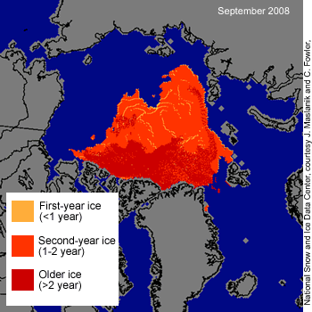
Sciencedaily: Arctic Literally On Thin Ice, According To New Satellite Data
Associated Press: Arctic sea ice thinnest ever going into spring
[ Bericht 31% gewijzigd door barthol op 07-04-2009 01:16:53 ]
Huidige trend atmosf. CO2 Mauna Loa: 411 ppm ,10 jaar geleden: 387 ppm , 25 jaar geleden: 358 ppm
Vooralsnog is er nog niet veel van te zien, maar dat komt natuurlijk vooral eind augustus. Zo vroeg in het seizoen valt er met geen enkele zekerheid te zeggen wat de eindstand zal gaan zijn. Je kent enkele variabelen, zoals dikte en leeftijd, maar anderen zoals wind en temperatuur zijn niet op zo'n termijn voorspelbaar. De temperatuur is nu nog ongewoon koud op de Noordpool, zeker in vergelijking met recente jaren, wat betekent dat de sneeuwlaag die er op ligt voorlopig het ijs eronder nog zal beschermen. We hebben ook nog geen enkel idee wat voor windpatronen er deze zomer zullen zijn; wordt het ijs naar het warme zuiden geblazen of juist door de wind op z'n plek gehouden?
Anyway, update:
De wereld als geheel heeft nagenoeg een normale oppervlakte ijs, met dien verstande dat de Zuidpool wat groter dan normaal is en de Noordpool wat kleiner. Trend voor de zuidpool blijft +0,13 miljoen vierkante kilometer per decennium, en ondanks dat de Noordpool al een half jaartje boven de lange-termijn trend zit, blijft deze ook -0,5 per decennium.
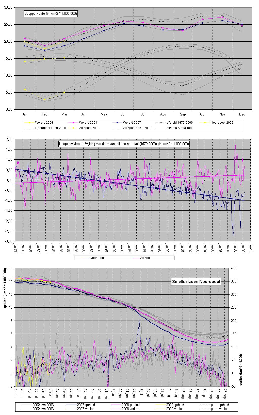
Zie ook de FPquote:Antarctic sea ice increasing: study
In recent years all the headlines have been about ice melting in some of the globe's chilliest places. But it seems that global warming may actually be leading to an increase in sea ice in parts of the Antarctic.
Scientists in the United Kingdom have produced a study which shows ice has grown by 100,000 square kilometres each decade in the past 30 years.
The increase is being put down to the hole in the ozone layer.
The British Antarctic Survey combined with NASA to look at the levels of ice in the region over the long term.
What was clear was that climate change produces complex results. Instead of a widening hole in the ozone layer, produced by human activity, warming temperatures as they have in the Arctic, in Antarctica it was having the opposite effect.
Scientists such as Julienne Stroeve from the National Snow and Ice Data Centre in the United States say they are not that surprised by the news of the study and its findings.
"There's been a change in atmospheric circulation around Antarctica related to the stratospheric ozone depletion and this actually causes stronger winds, which then pushes the ice away from the coast in some regions of Antarctica, which actually then causes more new ice formation and increases the overall sea ice in that region," she said.
"In other parts of Antarctica the temperatures have been decreasing and this is again sort of what we've expected to see, at least according to what the climate models tell us should be happening.
"But if you look at the Antarctic Peninsula for example, that's where you've had really strong warming and you've had a warming of about 3 degrees Celsius in the last 50 years.
"And if you look at changes in sea ice in that region they all show very strong negative trends.
"The paper shows an overall positive trend if you look at all of Antarctica, but there's regional differences that are quite different from different regions.
"We have to deal with what we know about warming in certain regions and changes in circulation and wind patterns in other regions."
Dr Stroeve argues that the rate of ice expansion, even as it translates to hundreds of thousands of square kilometres, is relatively insignificant.
"This recent paper shows you know a change in the annual mean ice extent of Antarctica of only 0.97 per cent per decade which is really close to zero," she added.
"In contrast if you look at the Arctic, you see statistically significantly trends of about 4 per cent per decade in the opposite direction right now if you look at the annual mean. Certainly it's a very small change for the Antarctic.
"The Antarctic is very different than the Arctic and what we're noticing is that you'll see negative trends in some areas of the Antarctic and positive trends elsewhere.
vreemd toch altijd dat ze dit soort dingen niet voorspellen, maar dat ze achteraf zeggen niet verbaasd te zijn en het allemaal prima kunnen verklaren.
De trend in zee-ijs was al een tijdje duidelijk, het enige wat "nieuw" is, is de verklaring ervoor. Maar die is dan ook wel interessant:
Dus wetenschapper A zegt: "Zie je wel, Antarctica warmt op, precies zoals we altijd al gezegd hebben," en drie maanden later komt wetenschapper B en die zegt: "Zie je wel, het ijs wordt groter omdat Antarctica afkoelt, precies zoals we altijd al verwacht hadden."

Overigens is de temperatuurtrend in Antarctica sinds 1979 (volgens satellieten, dus niet volgens het model van Steig) ongeveer -1 graad per eeuw, dus ongeacht waarom het afkoelt, ben ik het wel met deze nieuwe studie eens dat Antarctica op dit moment aan het afkoelen is. Het vreemde is dat het afkoelen niet is afgeremd of gestopt op het moment dat het ozongat gestopt is met groeien, maar wie weet is dat een kwestie van momentum. Dat zou duidelijker moeten worden op het moment dat het gat ook echt aan het sluiten is.
De trend in zee-ijs was al een tijdje duidelijk, het enige wat "nieuw" is, is de verklaring ervoor. Maar die is dan ook wel interessant:
staat hier nou echt dat het vergrote ozongat een afkoelend effect heeft gehad in Antarctica? Ja, het staat er echt. In Antarctica heeft het vergrote gat een tegenovergesteld effect van de opwarming die het in het noorden heeft, dus afkoeling. Zijn ze nu al weer vergeten dat Steig et al eerder dit jaar "bewezen" hebben dat Antarctica niet afkoelt, maar opwarmt?quote:What was clear was that climate change produces complex results. Instead of a widening hole in the ozone layer, produced by human activity, warming temperatures as they have in the Arctic, in Antarctica it was having the opposite effect.
Dus wetenschapper A zegt: "Zie je wel, Antarctica warmt op, precies zoals we altijd al gezegd hebben," en drie maanden later komt wetenschapper B en die zegt: "Zie je wel, het ijs wordt groter omdat Antarctica afkoelt, precies zoals we altijd al verwacht hadden."
Overigens is de temperatuurtrend in Antarctica sinds 1979 (volgens satellieten, dus niet volgens het model van Steig) ongeveer -1 graad per eeuw, dus ongeacht waarom het afkoelt, ben ik het wel met deze nieuwe studie eens dat Antarctica op dit moment aan het afkoelen is. Het vreemde is dat het afkoelen niet is afgeremd of gestopt op het moment dat het ozongat gestopt is met groeien, maar wie weet is dat een kwestie van momentum. Dat zou duidelijker moeten worden op het moment dat het gat ook echt aan het sluiten is.

quote:The Wilkins Ice Shelf, on the western side of the Antarctic Peninsula, experienced multiple disintegration events in 2008. A rapid retreat started in February, near the end of the Antarctic summer. Another breakup began in May, during the Antarctic winter. And fresh cracks appeared on the shelf in late November 2008. By the beginning of 2009, a narrow ice bridge was all that remained to connect the ice shelf to ice fragments fringing nearby Charcot Island. That bridge gave way in early April 2009.
Days after the ice bridge rupture, on April 12, 2009, the Advanced Spaceborne Thermal Emission and Reflection Radiometer (ASTER) on NASA’s Terra satellite captured this image of the southern base of the ice bridge, where it connected with the remnant ice shelf. This image shows ice fragments of varying sizes mixed with ice mélange. A crack in the east reveals dark ocean water below. Although the ice bridge between the shelf and Charcot Island had played a role in stabilizing the ice fragments in the region, its rupture didn’t guarantee an immediate ice exodus. The Wilkins Ice Shelf experienced a breakup event in 1998, yet the ice blocks from that breakup froze in place for a decade.
In this image, the low angle of the Sun accentuates shadows, and highlights an interesting feature. The large slab of ice in the lower left corner of this image displays a slight linear bulge along its northeastern edge. This area of raised ice is consistent with ice shelf modeling in numerous studies.
An ice shelf is a thick slab of ice that is attached to a coastline. The seaward extension of the shelf floats on the water like sea ice. Unlike sea ice, however, ice shelves can have thicknesses in excess of 100 meters, with part of the ice front above water and part of it below. After part of an ice shelf breaks away, the remaining ice shelf, despite its thickness, doesn’t remain impervious to the change. In both ice and water, pressure increases with depth, but the pressure gradient is steeper in water. This means that ocean water tends to deform the ice, pushing inward on the ice slab’s front. On its top surface, the ice slab bulges, and its top edge rotates outward and downward. The raised area along the front of the ice slab in this image suggests that ocean water has deformed this ice slab as predicted.
ijs op de Noordpool dikker dan verwacht:
da's nog eens wat anders dan we van de Amerikaanse wetenschappers horen
bronquote:Das Forschungsflugzeug "Polar 5" beendet heute in Kanada seine jüngste Arktis-Expedition. Bei dem Flug haben Forscher die aktuelle Eisstärke gemessen am Nordpol gemessen, und zwar in Gebieten, die nie zuvor überflogen worden sind. Ergebnis: Das Meer-Eis in den untersuchten Gebieten ist offenbar dicker, als die Wissenschaftler vermutet hatten.
Normalerweise sei neu gebildetes Eis nach zwei Jahren gut zwei Meter dick. "Hier wurden aber Eisdicken von bis zu vier Metern gemessen", sagte ein Sprecher des Bremerhavener Alfred-Wegener-Instituts für Polar- und Meeresforschung.
da's nog eens wat anders dan we van de Amerikaanse wetenschappers horen
update: de cijfers over april zijn binnen, en de Noordpool heeft zich (in vergelijking met recente jaren) voorbeeldig gedragen. We moeten terug naar 2001 voor een aprilmaand met meer ijs dan afgelopen maand. Er lag dus ook iets meer ijs dan vorig jaar in april, maar als we naar de dagelijkse voortgang kijken, zien we iets belangrijkers: vorig jaar begon met relatief veel ijs, en eindigde met minder. Dit jaar begon ietsje lager, maar eindige flink boven alle recente jaren. Dat is goed nieuws, want dat extra ijs weerkaatst zonlicht terug de ruimte in dat anders het water had opgewarmd en meer ijs had doen smelten. Dat is een voordeel wat ook in komende maanden zou kunnen doorwerken. Overigens is de stand dan wel hoger dan afgelopen jaren, we zitten nog steeds iets onder de normaal, en de trend blijft -0,5 miljoen vierkante kilometer per decennium.
De Zuidpool zit in het groeiseizoen, en loopt flink voor op schema. In april lag er gemiddeld een miljoen vierkante kilometer meer zee ijs dan normaal, en begint daarmee weer aardig in de buurt van een record te komen. Trend blijft onveranderd op +0,13 miljoen vierkante kilometer per jaar.
De wereld als geheel had daardoor een overschot van 0,6 miljoen vierkante kilometer aan zee ijs.
Grafiekjes:
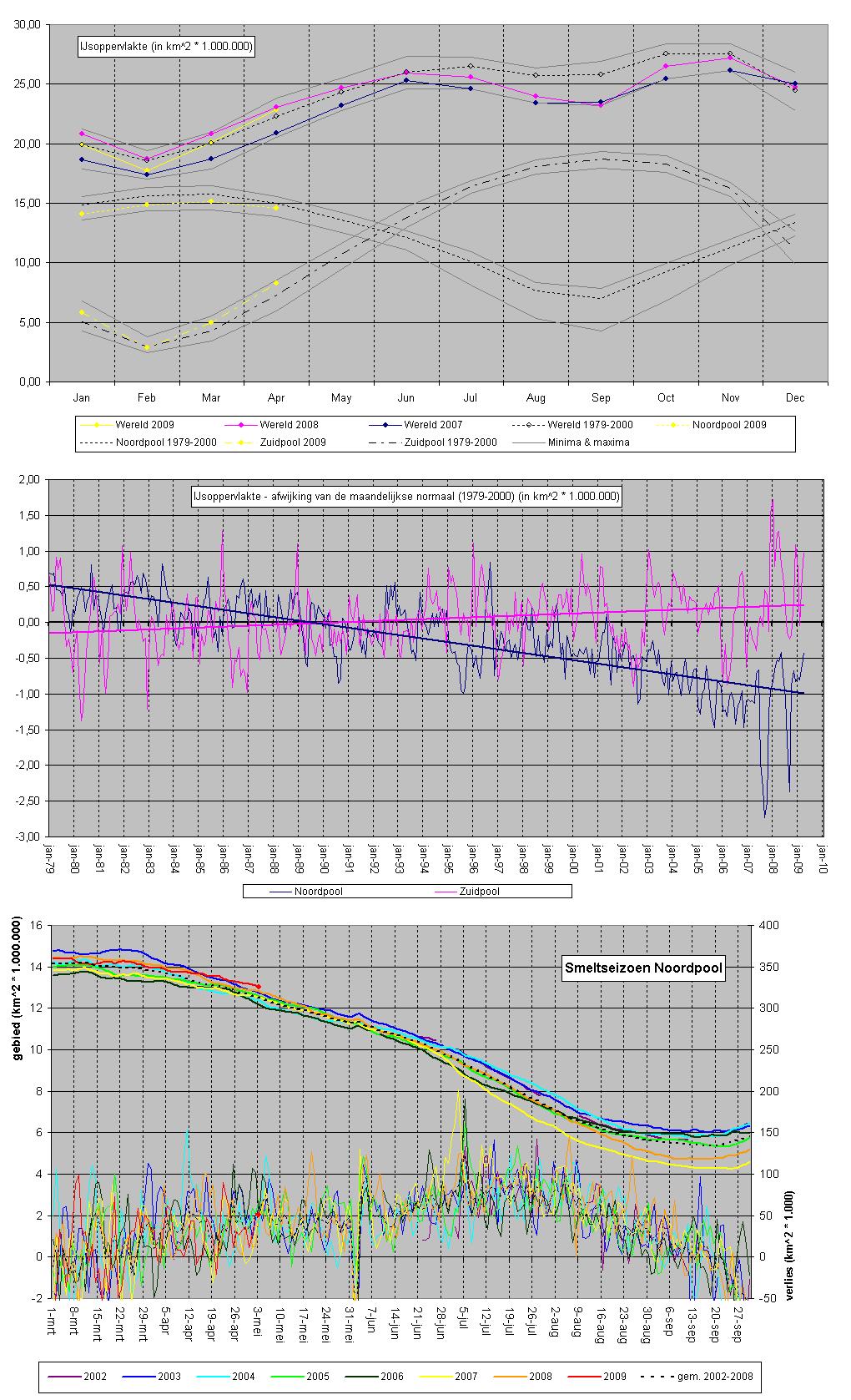
quote:New warning over Arctic ice-cap
The Arctic ice-cap, a permanent feature for at least 100,000 years, could vanish in summertime far sooner than predicted, a leading scientist says.
Professor Peter Wadhams, from the University of Cambridge, told BBC News he has brought forward his estimates of the ice-cap's demise.
He believes the ice is now so thin that almost all of it will disappear in about a decade.
He says it will become seasonal, forming only during the winter.
He told the BBC: "By 2013 we will see a much smaller area in summertime than now, and certainly by about 2020, I can imagine that only one area will remain in summer."
His assessment is based on analysis of nearly 40 years of sonar data gathered on Royal Navy submarines patrolling beneath the ice - the first, HMS Dreadnought, was in 1971.
Until recently, most climate forecasts suggested that the Arctic Ocean would have ice-free summers only towards the end of the century.
The most extreme scenario was for the ice to retreat as soon as 2013, but that was dismissed by many as far too soon.
Now Professor Wadhams, who has studied the Arctic for the past 40 years, says that there is "almost a breakdown" in the ice-cover.
Over most of the Arctic, there has been a massive decline in the amount of so-called multi-year ice - ice that is tough enough to withstand the summer warmth.
Much of what is left of this ice accumulates in an area north of Greenland and Ellesmere Island in Canada, and may form what he calls "a last holdout, a kind of Alamo".
Professor Wadhams said: "The change is happening so fast. It's the result of this steady thinning over four decades that has brought it to a state where its summer melt is causing it to disappear.
"It's like the Arctic is covered with an egg shell and the egg shell has been thinning to the point where it is now just cracking completely."
The rest of the story continues here...
Hmm, ik bekijk de ijsbedekking elke dag en zoals Ahred al zei, het ijs lijkt zich voorbeeldig te gedragen.quote:
De ijsoppervlakte is nog steeds groter dan het in de laatste jaren was rond deze tijd.
Zou de schijn bedriegen?
Huidige trend atmosf. CO2 Mauna Loa: 411 ppm ,10 jaar geleden: 387 ppm , 25 jaar geleden: 358 ppm
Nou, ik geloof zeker dat meneer Wadhams gelijk heeft dat het ijs in de afgelopen 40 jaar minder, dunner en gemiddeld jonger is geworden. Ook nu zitten we nog onder de normaal (1979-2000), en dit is in vergelijking met recente jaren een briljant jaar - extent is groter dan verwacht, dikte is beter dan verwacht, er is weer iets meer meerjarig ijs dan vorig jaar, etc. Maar meneer Wadhams negeert wel het feit dat zijn studie is begonnen op het hoogtepunt (qua ijs) van een cyclus, die mogelijk in de afgelopen jaren haar dieptepunt bereikt heeft. Voor een correcte analyse moet je natuurlijk van top tot top of van dal tot dal of iets dergelijks kijken, niet van top tot dal en dan een lineaire regressie toepassen om de toekomst te voorspellen. Als je het huidige dal vergelijkt met de jaren 30/40 (het vorige dal) is de achteruitgang een stuk minder uitgesproken dan in vergelijking met de jaren 70.
Hier is bijvoorbeeld een artikel uit maart 2005 (toen er nog geen enkel zicht op herstel was), waarin zij het vermoeden uiten dat de pool binnen 5 jaar zou kunnen beginnen met een herstel. Uiteraard betekent dat in een 60 tot 80 jarige cyclus dat het nog wel een aantal jaar kan duren voor het echt duidelijk wordt welk deel van de trend in de afgelopen decennia structureel is, en welk deel cyclisch.
Hier is bijvoorbeeld een artikel uit maart 2005 (toen er nog geen enkel zicht op herstel was), waarin zij het vermoeden uiten dat de pool binnen 5 jaar zou kunnen beginnen met een herstel. Uiteraard betekent dat in een 60 tot 80 jarige cyclus dat het nog wel een aantal jaar kan duren voor het echt duidelijk wordt welk deel van de trend in de afgelopen decennia structureel is, en welk deel cyclisch.
quote:Origin of Antarctic ice revealed
Incredible peaks and valleys, buried beneath ice for 14 million years, have revealed evidence of how the East Antarctic ice sheet first formed.
Scientists used radar to map an area of the Gamburtsev mountains - believed to be the point of origin of the ice.
The region would have been cold enough for the first glacier to form.
Writing in the journal Nature, the researchers say their findings provide important clues about how the ice sheet will behave as our climate changes.
"This is the largest reservoir of ice on Earth, and the most poorly understood place on our planet," said the British Antarctic Survey's Fausto Ferraccioli, a scientist involved in a separate international project to study the region.
He explained that the elevation and location of the Gamburtsev Mountains - in the centre of the ice sheet - made them an "ideal place" for the formation of the very first ice.
Icy unknown
Sun Bo from the Polar Research Institute of China, who led this study, has now provided further insight into the evolution of the ice sheet.
He and his colleagues travelled 1,235km (767 miles) by tractor train from a research station at the edge of East Antarctica, to the summit of Dome A of the Gamburtsev range, near the centre.
Dr Sun's team then attached radar equipment to the tractor and drove around, meticulously surveying a 30km by 30km square of the glacial region.
Their radar revealed a landscape that, 14 million years ago, looked similar to the European Alps.
"This is true scientific exploration," said Martin Siegert, head of the school of geosciences at Edinburgh University, who was also involved in the study.
"There's nothing to guide you really. Peering down at the ice sheet beneath your feet, you just don't know what's under there."
And for this type of exploration, the use of radio waves is very powerful.
When the waves reach the interface between ice and rock they bounce back, because of the difference in electrical properties between the two.
....Rest of story...

quote:Doek Ten Cate beschermt gletsjers
Textielconcern Ten Cate gaat mogelijk twee van de grootste gletsjers in Groenland beschermen tegen afbrokkeling.
Het Almelose bedrijf heeft een doek ontwikkeld die geen warmte doorlaat, waardoor de gletsjers niet verder smelten. Inmiddels zijn er in het Oosternrijkse Innsbruck proeven gedaan met het doek en het blijkt dat de gletsjers door het doek zestig procent minder smelten. Ook in Groenland zijn proeven gestart.
RTV Oost
quote:Argentine Glacier Advances Despite Global Warming
BUENOS AIRES, Argentina — Argentina's Perito Moreno glacier is one of only a few ice fields worldwide that have withstood rising global temperatures.
Nourished by Andean snowmelt, the glacier constantly grows even as it spawns icebergs the size of apartment buildings into a frigid lake, maintaining a nearly perfect equilibrium since measurements began more than a century ago.
"We're not sure why this happens," said Andres Rivera, a glacialist with the Center for Scientific Studies in Valdivia, Chile. "But not all glaciers respond equally to climate change."
Viewed at a safe distance on cruise boats or the wooden observation deck just beyond the glacier's leading edge, Perito Moreno's jagged surface radiates a brilliant white in the strong Patagonian sun. Submerged sections glow deep blue.
And when the wind blows in a cloud cover, the 3-mile-wide glacier seems to glow from within as the surrounding mountains and water turn a meditative gray.
Every few years, Perito Moreno expands enough to touch a point of land across Lake Argentina, cutting the nation's largest freshwater lake in half and forming an ice dam as it presses against the shore.
The water on one side of the dam surges against the glacier, up to 200 feet above lake level, until it breaks the ice wall with a thunderous crash, drowning the applause of hundreds of tourists.
"It's like a massive building falling all of the sudden," said park ranger Javier D'Angelo, who experienced the rupture in 2008 and 1998.
The rupture is a reminder that while Perito Moreno appears to be a vast, 19-mile-long frozen river, it's a dynamic icescape that moves and cracks unexpectedly.
"The glacier has a lot of life," said Luli Gavina, who leads mini-treks across the glacier's snow fields.

Maandelijkse update wat later dan normaal, maar dat komt omdat nu de spannende weken pas echt beginnen. De zon staat op z'n hoogst boven de horizon, en schijnt nu 24 uur per dag op het ijs. Maar eerst mei.
Hoewel in de laatste week van mei het verschil tussen dit jaar en 2007 en 2008 grotendeels is weg gesmolten, was de gemiddelde ijsdekking van de noordpool in mei bijna normaal. We moeten (net als april) terug naar 2001 om een mei met meer ijs op de noordpool te zien.
De zuidpool had wederom een maand in de buurt van een record, dus dat gaat prima. Samen hadden de noord- en zuidpool dus ongeveer een half miljoen vierkante kilometer meer drijfijs dan normaal.
Ook in de eerste weken van juni was de extent iets groter dan in de afgelopen twee jaar, al is het verschil behoorlijk klein. Als het oppervlak nu zo dicht op dat van 2007 zit, is er dan een grote kans op herhaling? Dat hangt vooral van de komende weken af. In de derde grafiek zie je dat 2007 tot ongeveer deze week vrijwel gelijk op ging met de andere jaren. Dan zie je opeens dat er in korte tijd heel veel ijs smelt, en het verschil met de andere jaren snel veel groter wordt. Aan het eind van het seizoen komt 2008 nog behoorlijk in de buurt, maar kan het gat niet meer overbruggen. Dat is belangrijk, want 2008 smolt laat in het seizoen harder dan ooit. De grote vraag is wat de extent dit jaar gaat doen - volgt het 2007, of blijft het meer bij 2008 in de buurt? In het eerste geval is de kans groot op een nieuw record, in het laatste geval lijkt dit zeer moeilijk te worden.
De onderste van de 4 grafieken probeert ook om iets over de toekomst te zeggen. Omdat deze grafiek lastig af te lezen is wat uitleg: op de horizontale as staat hoeveel ijs er op een bepaalde datum lag. Op de vertikale as staat hoeveel ijs er aan het einde van het seizoen overbleef. De verschillende kleurengroepen geven aan welke datum dat is. Je ziet dat vroeg in de lente, de stippen (iedere stip is een jaar) ver van de trendlijn zitten. Dat wil zeggen dat hoeveel ijs er vroeg in de lente ligt, weinig informatie geeft over het uiteindelijke minimum. Naarmate het seizoen vordert komen de stippen dichter bij de trendlijn, en kun je een betere uitspraak doen over waar het heen gaat. Bij iedere trend staat een R2 waarde. Deze geeft aan hoe goed de trend de waardes kan verklaren op een schaal van 0 (geen verklarende kracht) tot 1 (perfecte verklarende kracht). Op 1 mei zie je zelfs een negatiefe R2 - dit wil zeggen dat des te groter de oppervlakte op 1 mei is, des te kleiner wordt het minimum (de waarde zit echter zo dicht bij de nul dat ik hier geen waarde aan zou hechten).
De rode stippen geven de meest recente data weer (21 juni) met een voorspelling voor het minimum van dit jaar. Op basis van hoe ver de trend er in andere jaren naast zat, is een schatting gemaakt van hoe veel foutmarge er in deze voorspelling zit. Statistisch gezien zou je verwachten dat 95% van alle jaren die op 21 juni 10,36 miljoen vierkante kilometer extent hadden, binnen de getekende marge zou vallen. De kans op een nieuw record is wat dat aan gaat dus erg klein, maar merk op dat de R2 op dit moment nog slechts 0,14 is. Erg veel waarde zou ik hier dus nog niet aan hechten. Eerst maar eens de komende weken afwachten.
Wie geen zin heeft om te wachten op m'n updates: een dagelijkse data vind je hier.

UPDATE!
eerst juni maar: gemiddelde oppervlak van de noordpool was op wat wisselgeld na gelijk aan dat in 2004, 2007 en 2008, en wat groter dan 2005 en 2006. Weinig nieuws dus. Zuidpool is met een overschot van ruim een half miljoen vierkante kilometer wat kleiner dan 2008, maar zit nog altijd niet alleen boven normaal, maar ruim boven de (stijgende) trendlijn. Totaal van de noord- en de zuidpool samen was een haar onder normaal.
Dan de actuele stand van zaken. We hebben de eerste week van juli gehad, dit is de week waarin de dagen met de grootste verliezen te zien zijn. Al zijn er later in juli ook nog wel weken waarin het gemiddelde per dag hoger ligt. De eerste week van juli was vooral voor het recordjaar 2007 slopend. Om het minimum-record van 2007 te breken, mag er niet te veel "achterstand" opgelopen worden in deze week. Later in het seizoen zijn de verliezen per dag minder, en is het dus lastiger om een achterstand in te halen.
Dit jaar zagen we een piek die lager was dan 2005, 2006 en 2007 in deze week hadden (geen enkele dag boven 150.000 vierkante kilometer verlies), maar de piek was wel breed, waardoor het gemiddelde per dag boven alle jaren op 2007 na uit kwam. De afgelopen dagen echter waren juist weer zeer rustig, waardoor het totale oppervlak nog steeds vergelijkbaar is met dat van 2005 en 2008.
2007 verloor rond deze dagen bijna 100.000 vierkante kilometer ijs per dag meer dan er nu te zien is. Als dat niet heel snel verandert, lijkt het uitgesloten dat we dit jaar een nieuw record gaan zien. Sterker nog: als dat niet snel verandert, is de kans groot dat we een flinke groei tov van 2008 kunnen zien, want ook vorig jaar verloren we op dit punt zo'n 50.000 vierkante kilometer per dag meer dan we de afgelopen paar dagen gezien hebben.
Statistisch gezien zou dit jaar iets onder 2005 uit moeten komen, met een 95% zekerheidinterval tussen de 4,6 en 6 miljoen vierkante kilometer. (zie vorige post voor uitleg)

Duitse rederij wil Arctische NO-passage gebruiken
Rederij Beluga uit Bremen (Duitsland) hoopt deze zomer de Arctische Noordoost-passage te kunnen gebruiken voor vrachtvervoer per schip. Het zou voor het eerst zijn dat een niet-Russisch schip de tocht ten noorden van Siberië volbrengt.
Een poging van dezelfde rederij vorig jaar kreeg geen toestemming van de Russische autoriteiten. De Noordoost-passage, de zeeroute tussen Europa en Azië langs het Arctische noorden van Siberië, was dat jaar geblokkeerd door ijs tussen de Laptev Zee en de Kara Zee.
In die contreien is momenteel veel minder ijs. De Duitse rederij wil onderdelen vervoeren voor een elektriciteitscentrale in Surgut, Siberië, vanaf Zuid-Korea. Ontscheping moet dan plaatsvinden in de havens van Nowy Urengoj, gelegen oostelijk van Nova Zembla. Het is de bedoeling daarna door te varen naar Moermansk of Rotterdam.
Russische schepen varen in de zomermaanden regelmatig naar Siberische bestemmingen, vergezeld van krachtige ijsbrekers. Maar een niet-Russisch schip, zonder ijsbreker, zou een unicum betekenen voor de Noordoostelijke doorvaart. De Duitse rederij heeft deze zomer drie vrachtschepen in de planning staan voor deze doorvaart, een en ander afhankelijk van Russische toestemming: de schepen Family, Fraternity en Foresight.
vwk
Ze durven wel zonder ijsbreker.
vandaag is ook de data over juli op de site van het NSIDC gepubliceerd. De Noordpool zat qua extent wat onder 2008, maar verrassend genoeg qua area een fractie boven 2008. De conclusie lijkt dat er iets grotere gebieden zonder ijs waren, maar dat er op de plaatsen waar wel ijs lag, het ijs iets minder gefragmenteerd was, wat een positieve invloed zou kunnen hebben op het verdere smeltverloop.
De zuidpool zat iets boven normaal, praktisch op de trendlijn. Gecombineerd had de wereld dus iets minder ijs (extent) dan vorig jaar. Aangezien beide polen zo vlak bij de trendlijn zaten, is daar geen verschil in.
Als we naar de dagelijkse data kijken (derde grafiek), zien we dat de noordpool het grootste deel van juli zeer snel smolt en op weg leek om 2007 te volgen, Tot er rond 25/26 juli opeens een enorme vertraging inzette. Ik heb daarom ook een grafiek toegevoegd met hoeveel ijs er gemiddeld per dag smolt met een tien daags zwevend gemiddelde. Daarin is duidelijk te zien dat het smelttempo deze juli hoger lag dan enig ander jaar, op 2007 na, en zelfs een week boven het tempo van 2007 zat. Sinds 26 juli is het tempo echter volledig ingestort, en loopt snel richting en zelfs onder het tempo van 2006. (let op dat het dunne gedeelte van de rode lijn onvolledig is; de dikke rode lijn heeft 100% van de data, het dunne gedeelte loopt van 91% tot 55%, dus het uiteinde kan nog iets veranderen.)
De grote vraag is natuurlijk of 2009 vanaf nu het pad van 2006 gaat volgen, of toch weer kan versnellen tot 2008-niveau of hoger. In de laatste grafiek zie je weer de voorspelling op basis van correlatie tussen de grootte op 3 augustus en het uiteindelijke minimum, met de onzekerheidsmarge gebaseerd op hoe ver voorspellingen voor 2002-2008 er naast zaten. Daaruit blijkt dat het minimum grofweg tussen 4,6 en 5,6 miljoen vierkante kilometer terecht zou moeten komen. Een nieuw record lijkt uitgesloten, op basis van deze benadering.
[ Bericht 0% gewijzigd door Ared op 04-08-2009 11:05:00 ]
De zuidpool zat iets boven normaal, praktisch op de trendlijn. Gecombineerd had de wereld dus iets minder ijs (extent) dan vorig jaar. Aangezien beide polen zo vlak bij de trendlijn zaten, is daar geen verschil in.
Als we naar de dagelijkse data kijken (derde grafiek), zien we dat de noordpool het grootste deel van juli zeer snel smolt en op weg leek om 2007 te volgen, Tot er rond 25/26 juli opeens een enorme vertraging inzette. Ik heb daarom ook een grafiek toegevoegd met hoeveel ijs er gemiddeld per dag smolt met een tien daags zwevend gemiddelde. Daarin is duidelijk te zien dat het smelttempo deze juli hoger lag dan enig ander jaar, op 2007 na, en zelfs een week boven het tempo van 2007 zat. Sinds 26 juli is het tempo echter volledig ingestort, en loopt snel richting en zelfs onder het tempo van 2006. (let op dat het dunne gedeelte van de rode lijn onvolledig is; de dikke rode lijn heeft 100% van de data, het dunne gedeelte loopt van 91% tot 55%, dus het uiteinde kan nog iets veranderen.)
De grote vraag is natuurlijk of 2009 vanaf nu het pad van 2006 gaat volgen, of toch weer kan versnellen tot 2008-niveau of hoger. In de laatste grafiek zie je weer de voorspelling op basis van correlatie tussen de grootte op 3 augustus en het uiteindelijke minimum, met de onzekerheidsmarge gebaseerd op hoe ver voorspellingen voor 2002-2008 er naast zaten. Daaruit blijkt dat het minimum grofweg tussen 4,6 en 5,6 miljoen vierkante kilometer terecht zou moeten komen. Een nieuw record lijkt uitgesloten, op basis van deze benadering.

[ Bericht 0% gewijzigd door Ared op 04-08-2009 11:05:00 ]
Erosie door rivieren gelijk aan dat van gletsjers
Erosie maakt het landschap een kopje kleiner. Wetenschappers becijferden dat gletsjers daar zeer bedreven in waren. Nu blijkt dat rivieren net zo snel eroderen. Op langere tijdsschaal neemt de erosiesnelheid van gletsjers zelfs dramatisch af. Een laatste resultaat van het onderzoek van Koppes en Montgomery is dat ook mensen flinke erosie veroorzaken.
Beeld je hoge pieken met daarop schurende gletsjers en kabbelende bergriviertjes in en bedenk waar snellere erosie optreedt. Lang dachten ook wetenschappers dat erosie door gletsjers veel sneller ging dan erosie door rivieren. Nieuw onderzoek van de Nederlandse Michele Koppes en de Amerikaan David Montgomery gepubliceerd in Nature Geoscience zet deze theorie op zijn kop. Gletsjers en rivieren eroderen verrassend genoeg namelijk ongeveer even snel, zeker op tijdsschalen van miljoenen jaren.
Erosie door gletsjers en rivieren
Eerder onderzoek liet zien dat erosiesnelheden van gletsjers 1-10 maal sneller zouden zijn dan die van rivieren bij bekkens van gelijke grootte. In het kustgebergte van Alaksa is de erosie door gletsjers zelfs 10 mm per jaar, terwijl het gebergte slecht 1-4 mm per jaar omhoog komt. Netto erosie dus. Verder werd een paar weken geleden bekend dat de hoogte van de sneeuwlijn bepaalt hoe hoog een gebergte kan worden. Genoeg om te stellen dat erosie door gletsjers belangrijk is.
Waar de gletsjer stopt, begint de rivier, die sediment uiteindelijk in de oceaan brengt. Maar hoe snel eroderen rivieren werkelijk? Eerder onderzoek liet ook al zien dat erosiesnelheden oplopen tot meer dan 10 mm per jaar voor rivieren in twee gebieden: het Himalayagebergte en in Taiwan. Koppes en Mongomery hebben een enorme database van erosiesnelheden van gletsjers en rivieren over de hele wereld verzameld en geanalyseerd.
Zij ontdekten bijvoorbeeld dat de snelste erosie optreedt bij vulkanen die recent actief waren en na stormen en aardbevingen. Hier komt namelijk snel veel vrijliggend sediment beschikbaar. Dit zijn echter meestal uitzonderingen. Het belangrijkste resultaat is het volgende: in gebergtevormende gebieden zijn de erosiesnelheden van gletsjers en rivieren gelijk. Anders dan werd gedacht op basis van eerder onderzoek.
Reis door de tijd
De genoemde erosiesnelheden gaan over het nu. De onderzoekers namen echter ook het verleden mee in hun studie. Ze ontdekten dat de erosiesnelheden van gletsjers juist afnemen op langere tijdschalen. In de afgelopen tientallen jaren was de erosiesnelheid soms wel 100 mm per jaar, maar op een tijdschaal van miljoenen jaren is de erosiesnelheid slechts 1 mm per jaar. Een honderdvoudige afname dus.
Koppes en Montgomery denken dat de huidige, snelle erosie een gevolg is van de landschapsverandering door de vele smeltende gletsjers. Een tijdelijk fenomeen dus. Wat er gebeurt is dat er meer water tot op de bodem onder het ijs komt waardoor de gletsjers sneller ‘glijden’ en dus meer sediment verplaatsen. De erosiesnelheid van rivieren blijft daarentegen constant door de tijd heen.
Menselijke invloed
Niet alleen rivieren en gletsjers verplaatsen enorme hoeveelheden sediment. Ook de mens kan er wat van. In landbouwgebieden is de erosie even snel volgens de onderzoekers. In de afgelopen duizenden jaren verdween er daarom steeds meer sediment van het land naar de oceaan zoals bijvoorbeeld vruchtbare landbouwgrond.
De extra afvoer van sediment naar lagergeleden gebieden door gletsjersmelt en menselijke activiteiten is wellicht een extra steuntje in de rug voor gebieden die onder dreigen te lopen als de gevreesde zeespiegelstijging doorzet.
Met dank aan: Kennislink
In het kader van verzamelen van klimaat gerelateerde verhalen.quote:
Global warming has made Arctic summers hottest for 2,000 yearsThe Arctic has warmed as a result of climate change, despite the Earth being farther from the sun during summer months
Ian Sample, science correspondent guardian.co.uk, Thursday 3 September 2009 19.00 BST Article history
Global warming has nullified the effect of increasing distance between the sun and Earth during the Arctic summer solstice. Photograph: National Science Foundation
Warming as a result of increased levels of greenhouse gases in the atmosphere has overwhelmed a millennia-long cycle of natural cooling in the Arctic, raising temperatures in the region to their highest for at least 2,000 years, according to a report.
The Arctic began to cool several thousand years ago as changes in the planet's orbit increased the distance between the sun and the Earth and reduced the amount of sunlight reaching high northern latitudes during the summer.
But despite the Earth being farther from the sun during the northern hemisphere's summer solstice, the Arctic summer is now 1.2C warmer than it was in 1900.
Writing in the US journal Science, an international team of researchers describe how thousands of years of natural cooling in the Arctic were followed by a rise in temperatures from 1900 which accelerated briskly after 1950.
The warming of the Arctic is more alarming in view of the natural cooling cycle, which by itself would have seen temperatures 1.4C cooler than they are today, scientists said.
"The accumulation of greenhouse gases is interrupting the natural cycle towards overall cooling," said Professor Darrell Kaufman, a climate scientist at Northern Arizona University and lead author of the study.
"There's no doubt it will lead to melting glacier ice, which will impact on coastal regions around the world. Warming in the region will also cause more permafrost thawing, which will release methane gas into the atmosphere," he added.
Scientists fear that warming could release billions of tonnes of methane from frozen soils in the Arctic, driving global temperatures even higher.
On a tour of the Arctic this week, UN secretary general Ban Ki-moon urged nations to support a comprehensive accord to limit greenhouse gas emissions ahead of the organisation's climate summit in Copenhagen in December. The accord has been drawn up as a successor to the Kyoto Protocol, which expires in 2012.
The latest study comes months after scientists at the US National Oceanic and Atmospheric Administration (NOAA) warned that within the next 30 years Arctic sea ice is likely to vanish completely during the summer for the first time.
Kaufman and his colleagues reconstructed a decade-by-decade record of the Arctic climate over the past 2,000 years by analysing lake sediments, ice cores and tree rings. Computer simulations of changes in seasonal sunlight levels caused by the Earth's elliptical orbit and the shifting tilt of its axis verified the long-term cooling trend.
The scientists showed that summer temperatures in the Arctic fell by an average of 0.2C every thousand years, but that this cooling was swamped by human-induced warming in the 20th century.
"This study provides a clear example of how increased greenhouse gases are now changing our climate, ending at least 2,000 years of Arctic cooling," said Caspar Ammann, a climate scientist and co-author of the report at the National Centre for Atmospheric Research in Boulder, Colorado.
The Arctic began cooling around 8,000 years ago as natural variations in the Earth's orbit and angle of tilt reduced the amount of sunlight reaching high latitudes. Today, the planet is one million kilometres farther away from the sun during the northern hemisphere's summer solstice than it was in 1BC. This natural cooling effect will continue for 4,000 more years.
Previous research has shown that temperatures over the past century rose nearly three times as fast in the Arctic as elsewhere in the northern hemisphere. This is due to an effect called Arctic amplification, whereby highly reflective sea ice and snow melt to reveal darker land and sea water, which absorb sunlight and warm up more quickly.
De winter gaat langzaam weer beginnen in Siberie.
jan visserquote:Ondertussen raken de thermometers in Siberië in vorstige sferen. In Selagoncy werd gisternacht -10,1º gemeten. Overdag is er van kou weinig te merken. Zondagmiddag meldde Selagoncy 16,5º en tijdens de maandwisseling werd het daar nog circa 23 graden.