WKN Weer, Klimaat en Natuurrampen
Lees alles over het onstuimige weer op onze planeet, volg orkanen en tornado's, zie hoe vulkanen uitbarsten en hoe Moeder Aarde beeft bij een aardbeving. Alles over de verwoestende kracht van onze planeet en tal van andere natuurverschijnselen.


In navolging van Hurricane Season 2004 Deel 1 Hurricane Season 2004 en Deel 2 Hurricane Season 2004 -- Part 2
en Hurricane Season 2005 Deel 1 Tropical Cyclone Season 2005 en Deel 2 Hurricane/Cyclone Season 2005 - Part 2
en natuurlijk Hurricane Season 2006 Deel 1 [WFL] Hurricane Season 2006
is hier dan het tweede topic voor Hurricane Season 2006 voor zowel Atlantische, Indische als Pacifische stormen.
Algemene Info
met Hurricane Season bedoelden we in eerste instante de periode van 1 juni tot 30 november.
Deze periode wordt in het Atlantische basin en de Golf van Mexico gezien als het “Stormen-seizoen Naar aanleiding van documentairs over Hurricane Andrew 1992 en de newsberichten van de laatste jaren over o.a. Floyd, Stan, Katrina en Ivan beginnen we ook voor 2006 met een nieuw topic. Dit jaar wat vroeger dan normaal, want ook in Januari t/m mei komen er flink wat stormen voor in een ander deel van de wereld. Waarschijnlijk zal de kern van de discussie en de posts gaan over de periode 1-6-2006 t/m 30-11-2006. Daarvoor zal het wel niet storm gaan lopen
Hoe ontstaan ze?
op de site van Wikipedia kan je in het Nederlands nalezen hoe ze ontstaan en wat de belangrijkste energiebron is voor hun verwoestende kracht: het warme zeewater http://nl.wikipedia.org/wiki/Orkaan#Ontstaan
De BBC heeft er een interessante en leuke gif over gemaakt (met dank aan Roel)
http://news.bbc.co.uk/2/hi/science/nature/4588149.stm
Indeling en Kracht
De stormen worden ingedeeld op categorie. Vaak zijn het eerst "tropische stormen" (Tropical Depression, Tropical Storms), die overgaan op Orkaanstatus (Hurricane) Ze worden ingedeeld op windsnelheden via de Saffire Simpson Schaal
Tropical Depression 24-38 mph winds (38-61 km/u)
Tropical Storm 39-73 mph winds (62-118 km/u)
Hurricane Categorie 1 74-95 mph winds (119-153 km/u) -- 4/5 ft Storm Surge -- Vb. Danny 1997, Stan 2005
Hurricane Categorie 2 96-110 mph winds (154-177 km/u) - 6/8 ft Storm Surge -- Vb. Danielle 2004
Hurricane Categorie 3 111-130 mph winds (178-209 km/u) -- 9/12 ft Storm Surge -- Vb.Fran 1996, Beta 2005
Hurricane Categorie 4 131-155 mph winds (210-249 km/u) -- 13/18 ft Storm Surge -- Vb.Hugo 1989, Frances 2004
Hurricane Categorie 5 > 156 mph winds (meer dan 250 km/u) -- 18ft or more S.S. -- Vb.Andrew 1992, Mitch 1998 en Wilma, Katrina 2005
Namen
De stormen, die vaak gevormd worden op de atlantische oceaan en dan richting de Caribbean of de Oostkust van de VS gaan, krijgen de naam op Alfabetische volgorde. Voor het seizoen 2005 zijn de namen als volgt:
Atlantische Stormen 2006
Alberto, Beryl, Chris, Debby, Ernest, Florence, Gorden, Helene, Isaac, Joyce, Kirk, Leslie, Michael, Nadine, Oscar, Patty, Rafael, Sandy, Tony, Valerie, William
In het oosten van de pacific ontstaan ook Hurricanes, ook wel Cylonen en/of Tyfoons genoemd. Deze zorgen vaak voor weinig schade aan de Amerikaanse westkust.
Oost Pacifische Stormen 2006
Aletta, Bud, Carlotta, Daniel, Emilia, Fabio, Gilma, Hector, Ileana, John, Kristy, Lane, Miriam, Norman, Olivia, Paul, Rosa, Sergio, Tara, Vicente, Willa, Xavier, Yolanda, Zeke
Verder zijn er dan nog de stormen in het Noorden, Zuiden en Westen van de Pacific. Met name de stormen in het Noord/Westen komen vaak in het nieuws omdat ze Japan, Taiwan en China vaak teisteren, maar ook geheel Zuid Oost Azie kunnen treffen. De namen van deze stormen zijn terug te vinden op [url] [url=http://www.nhc.noaa.gov/aboutnames.shtml[url]]http://www.nhc.noaa.gov/aboutnames.shtml[url][/url]
Wanneer zijn die seizoenen nou precies?
ATLANTIC: 1 mei t/m 30 november
NORTH EAST PACIFIC Begin mei t/m begin November, met piek in Augustus/September
NORTH WEST PACIFIC Begin juli t/m eind November, maar eigenlijk hele jaar door aktieviteit.
NORTH INDIAN April t/m December met pieken in Mei en November
SOUTH INDIAN + WEST AUSTRALIAN Oktober t/m Mei met pieken in Februari en April
SOUTH WEST PACIFIC + EAST AUSTRALIANOktober tot eind April met piek in Februari.
Over het algemeen is Mei de rustigste maand en September de ergste.
Hoe ziet de voorspelling voor 2006 eruit
Volgens Phil Klotzbach en William Gray van CSU wordt ook 2006 een behoorlijk geweldadig jaar. Ze houden rekening met 17 stormen, waarvan 9 hurricanes worden en 5 zeer zware hurricanes, met een kans van 81% dat de VS door in elk geval 1 van de ‘big ones’ geraakt wordt. Meer info over deze voorspelling vindje hier http://hurricane.atmos.colostate.edu/Forecasts/2005/dec2005/
Enkele Links
1. Hurricane Season Special Edition Pagina van CNN voor 2005
2. National Hurricane Centre
3. Carribean Storm Network
4. Florida University Hurricane Website
5. Action News from Florida + Webcams
6. Hurricane Track
7. Website met satelietbeelden van de Caribbean en de rest van Amerika
8. Intellicast: Geavanceerde satellietfoto's en gifs van aktuele stormen
9. Data over temperatuur / wind
10. Tropical Storm Risico's van dit moment
11. Actuele Watertemperatuur van dit moment
12. Wikipedia Hurricanes/Tyfonen in het algemeen
13. Overzicht aktuele typhoons in de pacific
14. Alle stormen ter wereld van de laatste jaren in overzicht
Opmerkelijke Links
-- Hurricane Katrina CNN Special Report of the Killer Hurricane
-- Hurricane Katrina via WikiPedia
-- Hurricane Season 2005 -- Special van CNN
-- Hurricane Season 2004 -- Special van CNN
– Overzicht van Atlantische Stormen uit 2005
-- Spectaculaire Satelietshots van stormen
--Animatie van de alle Atlantische Stormen uit 2004
Openingspost
Klik hier
Actuele Radar in Golf van Mexico

=====================
Post hier je gegevens, nieuwsberichten, data en/of opmerkelijke zaken over de ‘Hurricanes en Cyclonen’ van 2006.

Volgens Wikipedia is de kustlijn 12 mijl of 19.3 km. Maar er zal vast niet veel van overblijven.quote:Op woensdag 30 augustus 2006 13:22 schreef Roel_Jewel het volgende:
[..]
Daar is dan niets meer van over . Kustlijn van 12 km, dus veel kleiner kan haast niet ...
Owja, miles. ff overheen gelezen . Maar idd, dat is zo weggevaagd .quote:Op woensdag 30 augustus 2006 13:26 schreef Light het volgende:
[..]
Volgens Wikipedia is de kustlijn 12 mijl of 19.3 km. Maar er zal vast niet veel van overblijven.
Gelukkig wonen er geen mensen. Op wat amerikaanse soldaten na dan, maar die zijn er al weggehaald.quote:Op woensdag 30 augustus 2006 13:27 schreef Roel_Jewel het volgende:
[..]
Owja, miles. ff overheen gelezen . Maar idd, dat is zo weggevaagd .
Ze hebben gisteren ofzo alle inwoners geëvacueerd idd. Alle 188 .quote:Op woensdag 30 augustus 2006 13:31 schreef Light het volgende:
[..]
Gelukkig wonen er geen mensen. Op wat amerikaanse soldaten na dan, maar die zijn er al weggehaald.
Voor de volledigheid:
We hebben het over het eilandje Wake Island dat door de supertyfoon Ioke wordt bedreigd. Zie Wikipedia voor meer informatie over het eilandje en hier voor meer informatie over Ioke:
Fotootjes van Ioke:
We hebben het over het eilandje Wake Island dat door de supertyfoon Ioke wordt bedreigd. Zie Wikipedia voor meer informatie over het eilandje en hier voor meer informatie over Ioke:
quote:The storm began to rapidly deepen again late on August 23 as it moved over increasingly warm water, reaching major hurricane status for the second time while moving to the west-northwest. From there, conditions would become even more favorable for development.
Overnight between August 24 and August 25, Ioke strengthened rapidly; becoming a Category 5 hurricane on the 25th - the first system originating from the Central Pacific to reach that intensity while still in the Western Hemisphere. Ioke then began to travel over a large environment highly favorable for hurricane development, and would maintain its strength for an extended period of time. Ioke also became the most intense hurricane ever to develop in the Central Pacific, with a central pressure of 921 mbar (27.19 inHg) at that point (which dropped to 920 mbar at its Central Pacific peak).
Ioke began to fluctuate in intensity afterward; weakened back to a Category 4 while undergoing an eyewall replacement cycle, regaining Category 5 strength on August 26. Ioke held that intensity until crossing the International Date Line that evening (August 27 after the crossover), becoming Typhoon Ioke in the process. The storm weakened to Category 4 strength according to the JTWC, but by 2100 UTC on August 29, the JTWC advised that Ioke had regained Category 5 strength for the third time.
Fotootje van Wake Island:quote:Records
* Ioke was the first Category 5 hurricane ever to form in the Central Pacific and reach that intensity while still in the Central Pacific. It was also only the fifth Category 5 hurricane on record in the Central Pacific (the other four formed in the Eastern or Western Pacific), and the first one since Hurricane John in 1994.
* Ioke was the most intense hurricane ever recorded in the Central Pacific with a recorded pressure at its peak of 920 mbar (27.179 inHg).
* Ioke tied Hurricane Emilia of 1994 by reaching Category 5 status twice, both as hurricanes in the Northern Pacific east of the International Date Line. Ioke would go on to restrengthen to a Category 5-equivalent typhoon based on one-minute windspeeds.

Fotootjes van Ioke:


Josty?quote:Op woensdag 30 augustus 2006 17:13 schreef aloa het volgende:
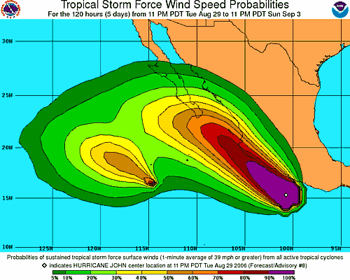
Kan dat 1 grote Orkaan worden John en Kristy?
Wat voor naam krijgt zoiets dan...
[afbeelding]


PUERTO VALLARTA, Mexico — Hurricane John churned parallel to Mexico's resort-studded Pacific Coast, lashing beaches with winds and rain and plotting a course that could take its center close to land before nicking the tip of Baja California.
Authorities in Puerto Vallarta, among Mexico's most-visited resorts, scrambled to prepare emergency shelters while organizing night patrols to hunt for possible storm-related damage late Wednesday. But tourists and residents alike remained calm

HONOLULU — Typhoon Ioke, the strongest Central Pacific tropical storm in more than a decade, continued to barrel toward recently evacuated Wake Island without losing any of its power.
Forecasters say the storm, which is now threatening no populated islands, is predicted to submerge the tiny atoll and destroy everything on it that is not concrete.
"It's a monster storm," said Jeff Powell, National Weather Service lead forecaster.
The isle's entire population of some 200 residents left via two Air Force evacuation flights to Hawaii on Monday. All were either U.S. military personnel, defense department civilians or military contractors.
The typhoon is expected to reach Wake Island at 1100 GMT Thursday with winds of up to 161 mph and gusts of up to 195 mph.
Ioke will likely pound Wake Island with powerful winds and rain for about 10 to 12 hours if the storm continues to move forward at current speeds, Powell said.
After hitting Wake Island, forecasters expect Ioke to head northwest over open ocean for several days in the direction of Japan. The typhoon will likely gradually lose power along the way, with its wind speeds expected to drop to 120 mph by early Monday
Dag eilandje .quote:Forecasters say the storm, which is now threatening no populated islands, is predicted to submerge the tiny atoll and destroy everything on it that is not concrete.
Hoe lief samen .quote:Op donderdag 31 augustus 2006 12:28 schreef Frutsel het volgende:
[afbeelding]
Hurricane John en Hurricane Kristy in één shot


Records van loke
Ioke heeft verschillende records gevestigd of geëvenaard:
De eerste vijfde-categorieorkaan in het basin van de centrale Grote Oceaan sinds orkaan John uit 1994
De eerste tropische cycloon, die zijn cyclogenesis, zijn promoties tot tropische storm, orkaan, majeure orkaan en het bereiken van de vijfde categorie doormaakte in het basin van de centrale Grote Oceaan.
De eerste vijfde-categorieorkaan met een Hawaïaanse naam.
Samen met Ivan uit het Atlantisch orkaanseizoen 2004 en orkaan Allen uit het Atlantisch orkaanseizoen 1980 de enige orkaan die drie maal tot de vijfde categorie promoveerde.
bron:
Tyfoon Ioke trok met windsnelheden tot 194 km/uur (10 min)/ 250 km/uur (1 min) op 31 augustus rakelings langs Wake-eiland. Alle 188 inwoners van het eiland werden in twee C-17 Globemaster III-viegtuigen geëvacueerd naar het eiland Oahu in Hawaï. Een automatisch weerstation op Wake-eiland nam een minimale druk waar van 930 mbar.
bron:

bron:
misschien is het inmiddels Fake Islandquote:Op vrijdag 1 september 2006 11:52 schreef Roel_Jewel het volgende:
En nu afwachten wat er nog van Wake Island over is. Er staat iig nog een automatisch weerstation .
De oceaan is toch best diep daar? Of maakt dat niet uit voor de temperatuur van het water?
/ ¦ ¦ / ¦ ¦
Waterdiepte zegt niet alles over de temperatuur. Zon is een factor, zeestromingen een grotere. Hoe die bij Japan zijn weet ik niet. En een typhoon is niet meteen dood als'ie in wat kouder water komt.quote:Op zaterdag 2 september 2006 14:29 schreef highway101 het volgende:
De oceaan is toch best diep daar? Of maakt dat niet uit voor de temperatuur van het water?
misschien hebben we maandag twee of zelfs drie tropische stormen.
één ervan kan land bedreigen.
één ervan kan land bedreigen.


Dostojewski: "Je kunt je niet van je eigen gezond verstand overtuigen door je buurman op te sluiten."


Dat ik dit topic nu pas zie. Ik moet dit topic maar eens in de gaten houden, tenslotte woon ik 20 miles van de kust van de golf van mexico (noord-florida).
Florence is nog steeds een Tropical Storm en wordt, als het goed is, dit weekend een Orkaan. Volgens het laatste plaatje gaat ie richting Bermuda.
Ze hebben wel grote plannen met Florence, als je kijkt naar waar ze die woensdag verwachten. En dan ook naar de locatie van dinsdag.quote:Op vrijdag 8 september 2006 17:38 schreef aloa het volgende:
Florence is nog steeds een Tropical Storm en wordt, als het goed is, dit weekend een Orkaan. Volgens het laatste plaatje gaat ie richting Bermuda.
[afbeelding]

Als orkaan komt ie wel hoog terecht. Waarschijnlijk zal ie ergens in Europa uitkomen. Maar dan als depressie.quote:Op vrijdag 8 september 2006 22:36 schreef Light het volgende:
[..]
Ze hebben wel grote plannen met Florence, als je kijkt naar waar ze die woensdag verwachten. En dan ook naar de locatie van dinsdag.

Hurricane Florence komt morgemiddag (nl-tijd) langs Bermuda.
zal nog aansterken tot een sterke categorie 2 hurricane.
zal nog aansterken tot een sterke categorie 2 hurricane.

Dostojewski: "Je kunt je niet van je eigen gezond verstand overtuigen door je buurman op te sluiten."
(CNN) -- Tropical storm Florence intensified into a Category 1 hurricane Sunday as it cut a path through the Atlantic and headed toward Bermuda with winds gusting up to 75 miles per hour, National Hurricane Center forecasters said Sunday.
The storm's center was about 360 miles south of the tiny British territory, moving north-northwest, the NHC said. Forecasters warn of storm force winds could reach 260 miles from its epicenter.
Bermuda residents should be making preparations to protect their lives and property as the storm system inched closer to the small island chain, The Bermuda Weather Service warned earlier.
NHC forecasters kept a Hurricane Watch and Tropical Storm Warning in effect for Bermuda, which means hurricane and tropical storm conditions are expected within 24 to 36 hours. A hurricane warning will likely be issued later Sunday.
Florence was ranked as a Category 1 Hurricane at 2 a.m., but forecasters predicted the storm could strengthen to a Category 2 storm, with winds in excess of 96 mph, when is passes near Bermuda early Monday.
Large ocean swells of up to 8 feet and dangerous surf, including rip currents, were affecting Bermuda's coast, as well as the northern Leeward Islands, the Virgin Islands, Puerto Rico, Hispaniola and Bermuda, the hurricane center said.
Weather forecasters in Bermuda said on its current track, the center of Florence could pass less than 10 miles from the islands. However, because of the erratic nature of hurricane movement, such long-range predictions can vary.
The storm is still not seen as a threat to the U.S. East Coast because it is expected to veer off to the northeast, out into the Atlantic Ocean, after passing Bermuda.
CNN


Florence is now just west of Bermuda and there are reports that hurricane force winds are being experienced on the small Atlantic island. Later today, the hurricane will begin to pull away and conditions will slowly improve. Until that time, strong winds, heavy rains and a storm surge along with battering waves will continue to affect Bermuda- we will keep an eye out for reports of damage from the island. Once Florence passes Bermuda it looks as though it will quickly move out in to the Atlantic on a path just south of the Canadian Maritimes. It is possible that large ocean swells will affect the East Coast and portions of the NE Caribbean over the next few days- these affects too will begin to subside as the week wears on.
Elsewhere, we are tracking TD #7 which is expected to become a tropical storm as it too is forecast to curve away from the United States. It is also possible that this depression will simply be torn apart by strong winds aloft and may not be an issue at all. In either case, we will be on top of the latest info from the NHC as this newest system evolves. In addition, there is a very strong tropical wave about to hit the water just off the coast of Africa which should go on to develop as it begins its track to the west. Most models show this feature getting turned out in to the Atlantic but it is quite early to know for sure- so we'll just have to watch and track. One things is for sure, the season is getting very active this week which is completely normal and quite expected. So far, there are no indications that any of the developing systems will affect land anytime soon. Once Florence moves on, we will look closer at the developing systems in the Atlantic. I will post another update here later this afternoon.
Elsewhere, we are tracking TD #7 which is expected to become a tropical storm as it too is forecast to curve away from the United States. It is also possible that this depression will simply be torn apart by strong winds aloft and may not be an issue at all. In either case, we will be on top of the latest info from the NHC as this newest system evolves. In addition, there is a very strong tropical wave about to hit the water just off the coast of Africa which should go on to develop as it begins its track to the west. Most models show this feature getting turned out in to the Atlantic but it is quite early to know for sure- so we'll just have to watch and track. One things is for sure, the season is getting very active this week which is completely normal and quite expected. So far, there are no indications that any of the developing systems will affect land anytime soon. Once Florence moves on, we will look closer at the developing systems in the Atlantic. I will post another update here later this afternoon.
Hurricane Florence treft Bermuda
11 september 2006 - Hurricane Florence heeft maandag flink huisgehouden op Bermuda. Florence is een klasse 1 hurricane met gemiddelde windsnelheden tussen 90 en 150 km/uur.
De hurricane trekt nu op ruime afstand van de Amerikaanse oostkust verder in noordelijke richting om daarna af te buigen naar het noordoosten. Naar verwachting transformeert het tropische systeem Florence woensdag nabij New Foundland in een extratropische depressie en worden de restanten vervolgens in de zonale stroming op de Oceaan opgenomen. Daardoor wordt het eind deze week ook in ons land wisselvalliger met kans op buien en mogelijk ook meer wind.
Inmiddels is de zevende tropische depressie in ontwikkeling en dat kan Gordon worden. De komende weken krijgen ook de Verenigde Staten vaker te maken met hurricanes die aan land gaan.
Website KNMI
[ Bericht 0% gewijzigd door #ANONIEM op 11-09-2006 22:18:51 ]
11 september 2006 - Hurricane Florence heeft maandag flink huisgehouden op Bermuda. Florence is een klasse 1 hurricane met gemiddelde windsnelheden tussen 90 en 150 km/uur.
De hurricane trekt nu op ruime afstand van de Amerikaanse oostkust verder in noordelijke richting om daarna af te buigen naar het noordoosten. Naar verwachting transformeert het tropische systeem Florence woensdag nabij New Foundland in een extratropische depressie en worden de restanten vervolgens in de zonale stroming op de Oceaan opgenomen. Daardoor wordt het eind deze week ook in ons land wisselvalliger met kans op buien en mogelijk ook meer wind.
Inmiddels is de zevende tropische depressie in ontwikkeling en dat kan Gordon worden. De komende weken krijgen ook de Verenigde Staten vaker te maken met hurricanes die aan land gaan.

Website KNMI
[ Bericht 0% gewijzigd door #ANONIEM op 11-09-2006 22:18:51 ]


Shanshan neemt inderdaad flink in kracht toe.quote:Op dinsdag 12 september 2006 11:29 schreef Frutsel het volgende:
En Shanshan zal deze week korte metten gaan maken met de eilandengroep rondom Okinawa Japan?
[afbeelding]


Ja maar niet naar Nederland helaas
Doe mee met het voorspellen van het weer!
Weekvoorspelling | Week 12 (invullen tot 16-03 - 11:59)
Maandvoorspelling Maart (Inzendingen gesloten)
Jaarvoorspelling 2025 / 2026
Weekvoorspelling | Week 12 (invullen tot 16-03 - 11:59)
Maandvoorspelling Maart (Inzendingen gesloten)
Jaarvoorspelling 2025 / 2026
ja eerst over de Azoren morgen als hurricane nog, en die zijn van Portugal inderdaad.
quote:A HURRICANE WARNING IS IN EFFECT FOR ALL OF THE AZORES ISLANDS. A
HURRICANE WARNING MEANS THAT HURRICANE CONDITIONS ARE EXPECTED
WITHIN THE WARNING AREA WITHIN THE NEXT 24 HOURS. PREPARATIONS TO
PROTECT LIFE AND PROPERTY SHOULD BE RUSHED TO COMPLETION.
Dostojewski: "Je kunt je niet van je eigen gezond verstand overtuigen door je buurman op te sluiten."
Kom maar op met de automatische weerstations links
Doe mee met het voorspellen van het weer!
Weekvoorspelling | Week 12 (invullen tot 16-03 - 11:59)
Maandvoorspelling Maart (Inzendingen gesloten)
Jaarvoorspelling 2025 / 2026
Weekvoorspelling | Week 12 (invullen tot 16-03 - 11:59)
Maandvoorspelling Maart (Inzendingen gesloten)
Jaarvoorspelling 2025 / 2026
pas op, voor dat je het weet krijg je weer een briefquote:Op dinsdag 19 september 2006 22:30 schreef SpeedyGJ het volgende:
Kom maar op met de automatische weerstations links

Mooi plaatje die helene is van ons
Doe mee met het voorspellen van het weer!
Weekvoorspelling | Week 12 (invullen tot 16-03 - 11:59)
Maandvoorspelling Maart (Inzendingen gesloten)
Jaarvoorspelling 2025 / 2026
Weekvoorspelling | Week 12 (invullen tot 16-03 - 11:59)
Maandvoorspelling Maart (Inzendingen gesloten)
Jaarvoorspelling 2025 / 2026
Donderdag komt gordon bij Portugal/Spanje aan.
Die krijgen het flink te verduren daar. Veel wind en heel veel regen.
Die krijgen het flink te verduren daar. Veel wind en heel veel regen.

Azores set for Hurricane Gordon
The Azores islands in the mid-Atlantic have been placed on high alert for Hurricane Gordon, which is due to hit the Portuguese territory shortly.
People and livestock have been told to stay indoors as forecasters warn the hurricane will bring heavy rain and winds of 170km/h (105mph).
Waves as high as 12 metres (40ft) are also predicted and the region's ports are expected to be the most exposed.
Some 240,000 people live in the nine Azores islands.
Farming and fishing are the mainstay of the economy of the islands, which lie about 1,500 km (930 miles) off the western coast of Europe.
Hurricane Gordon is expected to hit the islands at around 1800 local time (1800 GMT), with the archipelago's westernmost islands of Corvo and Flores taking its full force.
Ricardo Barros, vice president of the Azores Civil Protection Service, told the Associated Press news agency the islands' 1,200 emergency workers were prepared.
"We're ready," he said.
Air traffic to the islands is likely to be suspended until Hurricane Gordon leaves the region on Wednesday, he added.
A spokeswoman for Portugal's meteorological agency said the hurricane would weaken to a tropical storm before leaving the islands.
BBC News

Nee, denk ik ook niet. Helene gaat ook een stuk hoger dan Gordon en het water is daar ook een stuk kouder.quote:Op woensdag 20 september 2006 10:41 schreef Frutsel het volgende:
mjah, tegen de tijd dat ze daar aankomt is het niets meer ben ik bang
Maar ze zal nog wel voor veel wind en regen gaan zorgen, denk ik. Maar dan als een stormdepressie.
Met windsnelheden tot rond 130 km/uur teistert Gordon momenteel de Azoren. Tussen 10 en 11 uur meldde Santa Maria Airport (oostelijke Azoren) gemiddelde winden rond 90 met uitschieters tot 130 km/uur. Hurricanes die de Azoren treffen zijn zeldzaam maar niet uniek. In 1959 kregen de Azoren met Hannah te maken en in 1995 zaaide Tanya dood en verderf. Er vielen toen 30 doden te betreuren. In de loop van deze woensdag verlaat Gordon de Portugese eilandengroep en beweegt zich, transformerend tot een ‘extratropische depressie’, naar de wateren noordwest van Spanje. Vervolgens trekt het kleinschalige maar vinnige systeem naar Ierland waar het in de nacht naar vrijdag veel wind gaat veroorzaken. Gordon wordt uiteindelijk opgenomen in een omvangrijk lagedrukgebied ten westen van Ierland. De luchtdruk in de kern van dit systeem zakte de afgelopen nacht naar 964 hPa.
Bron: Weerman Jan Visser
Helene is echt een grote orkaan.
Gordon is een stuk kleiner. Boven Gordon zie je het lagedrukgbied, waar Gordon in opgenomen gaat worden.
Bron Foto:
Gordon is een stuk kleiner. Boven Gordon zie je het lagedrukgbied, waar Gordon in opgenomen gaat worden.

Bron Foto:

Helene zou ons wel eens kunnen bezoeken met een storm
Doe mee met het voorspellen van het weer!
Weekvoorspelling | Week 12 (invullen tot 16-03 - 11:59)
Maandvoorspelling Maart (Inzendingen gesloten)
Jaarvoorspelling 2025 / 2026
Weekvoorspelling | Week 12 (invullen tot 16-03 - 11:59)
Maandvoorspelling Maart (Inzendingen gesloten)
Jaarvoorspelling 2025 / 2026
En die storm gaat aan onze neus voorbij
Doe mee met het voorspellen van het weer!
Weekvoorspelling | Week 12 (invullen tot 16-03 - 11:59)
Maandvoorspelling Maart (Inzendingen gesloten)
Jaarvoorspelling 2025 / 2026
Weekvoorspelling | Week 12 (invullen tot 16-03 - 11:59)
Maandvoorspelling Maart (Inzendingen gesloten)
Jaarvoorspelling 2025 / 2026
Super-tyfoon Yagi met windstoten tot 315 Km/uur.
[ Bericht 19% gewijzigd door #ANONIEM op 23-09-2006 13:05:31 ]

[ Bericht 19% gewijzigd door #ANONIEM op 23-09-2006 13:05:31 ]
315 km/h?? valt mee
Doe mee met het voorspellen van het weer!
Weekvoorspelling | Week 12 (invullen tot 16-03 - 11:59)
Maandvoorspelling Maart (Inzendingen gesloten)
Jaarvoorspelling 2025 / 2026
Weekvoorspelling | Week 12 (invullen tot 16-03 - 11:59)
Maandvoorspelling Maart (Inzendingen gesloten)
Jaarvoorspelling 2025 / 2026
Tyfoon Xangsane op weg naar Vietnam
AMSTERDAM - Vietnam is begonnen met het evacueren van 180 duizend mensen omdat de orkaan Xangsane nadert vanaf de Fillippijnen. Daar zijn de afgelopen dagen 63 mensen overleden en zeventig mensen vermist als gevolg van de orkaan.
De autoriteiten hopen de evacuatie binnen een dag af te ronden. Zorgen zijn er nog om de 522 vissersboten met aan boord 4800 mensen, die nog op zee zijn. Militairen helpen vissers die in de havens arriveren om hun schepen veilig op het droge te brengen.
Xangsane, met windsnelheden tot 120 kilometer per uur, wordt zondag in Vietnam verwacht. Naast zware wind worden ook enorme regenbuien verwacht.
Nog veel vermisten na tyfoon Filipijnen
MANILLA - Het dodental tengevolge van de tyfoon Xangsane, die donderdag over het noordelijke deel van de Filipijnen raasde, is vrijdag opgelopen tot 48, terwijl tientallen mensen worden vermist.
Scholen, kantoren en financiële instellingen bleven vrijdag voor de tweede achtereenvolgende dag gesloten. Door de storm werden bomen ontworteld en ontstonden overstromingen en aardverschuivingen. Manilla en twee provincies hebben de noodtoestand uitgeroepen om een beroep te kunnen doen op rampenfondsen. Er zijn mariniers ingezet om bewoners te helpen met het opruimen van de ravage.
De meeste doden vielen in de provincie Laguna ten zuiden van Manilla. In de plaats Santa Rosa kwamen minstens negentien mensen om bij overstromingen en aardverschuivingen en in vijf andere plaatsen vielen nog vijftien doden. In Laguna worden verder nog 29 mensen vermist. De kustwacht meldde dat een jacht met minstens zes personen aan boord is verdwenen in de Baai van Manilla. Ook een opvarende van een boot die zonk in de provincie Batangas wordt vermist.
Onder de andere vermisten zijn zeker dertig mensen die in de plaats General Trias op een dijk stonden te kijken hoe huizen door overstromingen werden weggeslagen toen de dijk het begaf. Slechts een lijk werd geborgen.
Het noordelijke eiland Luzon, waar Manilla ligt, kwam donderdag zonder elektriciteit te zitten, maar vrijdag was een derde van het gebied weer voorzien.
De tyfoon zwakte op weg naar de Zuid-Chinese Zee richting Vietnam af tot een tropische storm, maar nam vrijdag weer in kracht toe, met windkracht 120 en windstoten tot 150 kilometer per uur. Vietnam trof vrijdag voorbereidingen om duizenden mensen uit zijn centrale kustgebied te evacueren, waar de tyfoon zondag wordt verwacht. Volgens de directeur van de meteorologische dienst is Xangsane even krachtig als de tyfoon Chanchu, die in mei aan naar schatting 270 Vietnamezen, merendeels vissers, het leven heeft gekost. Slechts van twintig vissers zijn de lijken gevonden.
AMSTERDAM - Vietnam is begonnen met het evacueren van 180 duizend mensen omdat de orkaan Xangsane nadert vanaf de Fillippijnen. Daar zijn de afgelopen dagen 63 mensen overleden en zeventig mensen vermist als gevolg van de orkaan.
De autoriteiten hopen de evacuatie binnen een dag af te ronden. Zorgen zijn er nog om de 522 vissersboten met aan boord 4800 mensen, die nog op zee zijn. Militairen helpen vissers die in de havens arriveren om hun schepen veilig op het droge te brengen.
Xangsane, met windsnelheden tot 120 kilometer per uur, wordt zondag in Vietnam verwacht. Naast zware wind worden ook enorme regenbuien verwacht.

Nog veel vermisten na tyfoon Filipijnen
MANILLA - Het dodental tengevolge van de tyfoon Xangsane, die donderdag over het noordelijke deel van de Filipijnen raasde, is vrijdag opgelopen tot 48, terwijl tientallen mensen worden vermist.
Scholen, kantoren en financiële instellingen bleven vrijdag voor de tweede achtereenvolgende dag gesloten. Door de storm werden bomen ontworteld en ontstonden overstromingen en aardverschuivingen. Manilla en twee provincies hebben de noodtoestand uitgeroepen om een beroep te kunnen doen op rampenfondsen. Er zijn mariniers ingezet om bewoners te helpen met het opruimen van de ravage.
De meeste doden vielen in de provincie Laguna ten zuiden van Manilla. In de plaats Santa Rosa kwamen minstens negentien mensen om bij overstromingen en aardverschuivingen en in vijf andere plaatsen vielen nog vijftien doden. In Laguna worden verder nog 29 mensen vermist. De kustwacht meldde dat een jacht met minstens zes personen aan boord is verdwenen in de Baai van Manilla. Ook een opvarende van een boot die zonk in de provincie Batangas wordt vermist.
Onder de andere vermisten zijn zeker dertig mensen die in de plaats General Trias op een dijk stonden te kijken hoe huizen door overstromingen werden weggeslagen toen de dijk het begaf. Slechts een lijk werd geborgen.
Het noordelijke eiland Luzon, waar Manilla ligt, kwam donderdag zonder elektriciteit te zitten, maar vrijdag was een derde van het gebied weer voorzien.
De tyfoon zwakte op weg naar de Zuid-Chinese Zee richting Vietnam af tot een tropische storm, maar nam vrijdag weer in kracht toe, met windkracht 120 en windstoten tot 150 kilometer per uur. Vietnam trof vrijdag voorbereidingen om duizenden mensen uit zijn centrale kustgebied te evacueren, waar de tyfoon zondag wordt verwacht. Volgens de directeur van de meteorologische dienst is Xangsane even krachtig als de tyfoon Chanchu, die in mei aan naar schatting 270 Vietnamezen, merendeels vissers, het leven heeft gekost. Slechts van twintig vissers zijn de lijken gevonden.
Leuk en wel maar
Dus dan de windstoten tegen de 1500km/h aan zitten
quote:Op zaterdag 30 september 2006 12:45 schreef Frutsel het volgende:
De tyfoon zwakte op weg naar de Zuid-Chinese Zee richting Vietnam af tot een tropische storm, maar nam vrijdag weer in kracht toe, met windkracht 120 en windstoten tot 150 kilometer per uur. Vietnam trof vrijdag voorbereidingen om duizenden mensen uit zijn centrale kustgebied te evacueren, waar de tyfoon zondag wordt verwacht. Volgens de directeur van de meteorologische dienst is Xangsane even krachtig als de tyfoon Chanchu, die in mei aan naar schatting 270 Vietnamezen, merendeels vissers, het leven heeft gekost. Slechts van twintig vissers zijn de lijken gevonden.
Dus dan de windstoten tegen de 1500km/h aan zitten
Doe mee met het voorspellen van het weer!
Weekvoorspelling | Week 12 (invullen tot 16-03 - 11:59)
Maandvoorspelling Maart (Inzendingen gesloten)
Jaarvoorspelling 2025 / 2026
Weekvoorspelling | Week 12 (invullen tot 16-03 - 11:59)
Maandvoorspelling Maart (Inzendingen gesloten)
Jaarvoorspelling 2025 / 2026

Dust Storms may Reduce Hurricane Activity
Dust storms swirling out of Africa's Sahara Desert may help reduce hurricane activity in the Atlantic Ocean, a new study suggests.
The findings aren't conclusive, but researchers led by Amato T. Evan of the University of Wisconsin-Madison found that years with more African dust had fewer tropical storms and years with less dust had more storms.
The study is reported in Tuesday's issue of Geophysical Research Letters.
Evan and his colleagues used satellite images to study the amount of African dust blown out over the Atlantic for the years 1982-2005 and compared that with tropical storm activity.
"While we cannot conclusively demonstrate a direct causal relationship, there appears to be a robust link between tropical cyclone activity and dust transport," they concluded.
"People didn't understand the potential impact of dust until satellites allowed us to see how incredibly expansive these dust storms can be," Evan said in a statement. "Sometimes during the summer, sunsets in Puerto Rico are beautiful, because of all the dust in the sky -- well that dust comes all the way from Africa."
Co-author Jonathan Foley, also of the University of Wisconsin, added: "These findings are important because they show that long-term changes in hurricanes may be related to many different factors."
Several recent studies have indicated a potential relationship between warming sea surface temperatures and increases in either the strength or number of tropical storms.
Other researchers have suggested a link between rain in North Africa and an increase in tropical storms, resulting from more easterly wave disturbances entering the Atlantic from Africa.
Dust blowing off the Sahara can spread widely and it is not unusual for it to be detected in the Caribbean and Florida.
The researchers suggest three possible ways the dust can affect storms:
-By introducing dry air into a storm it causes downdrafts, blocking the rising streams of air needed to fuel a storm.
-Midlevel winds accompanying the Saharan air cause wind shear, a change in direction with altitude that prevents rising currents from growing into storms.
-Warmth absorbed by the dust in the air can stabilize conditions, again blocking rising air.
Update(je) van Hurricanetrack.com
Geen enkele orkaan dit seizoen? Dat is toch niet wat men voorspeld had. Wel mooi voor al die amerikanen, even geen ellende dit jaar.quote:UPDATED: 4:30 pm EDT, October 12, 2006
FALSE ALARM IN THE TROPICS- NO DEVELOPMENT LIKELY
Just when it seemed we might have something to watch, it fizzles out. The tropical wave and associated surface low are not expected to do much more than provide additional moisture for portions of the Greater Antilles and NE Caribbean Sea. Upper level winds and other environmental conditions are just not favorable enough for any development right now. In fact, I see nothing on the global models to suggest that we will see anything significant for the rest of the month. I do believe now that we will end the season without a single hurricane hitting the United States or surrounding nations. We came close with a couple of systems but it was just not in the cards this time around. I am sure there are no complaints about that. I'll post another update tomorrow.
* I intend to live forever, so far so good! *

Het is ongelofelijk.. het ziet er idd naar uit dat er geen enkele storm aan land komt in de VS...
En dat terwijl ze nog een boven-gemiddeld seizeon voorspeld hadden.. kan je nagaan hoe onvoorspelbaar alles is. Maar ja, vorig jaar hadden we zelfs in december nog een storm, dus echt voorbij is het nog niet
En dat terwijl ze nog een boven-gemiddeld seizeon voorspeld hadden.. kan je nagaan hoe onvoorspelbaar alles is. Maar ja, vorig jaar hadden we zelfs in december nog een storm, dus echt voorbij is het nog niet
En dat terwijl het zeewater zelfs nog hoger lag dan vorig jaar. Als dit gebeurt zal zal het waarschijndelijk de eerste keer zijn dat amerika gespaart blijft.
Doe mee met het voorspellen van het weer!
Weekvoorspelling | Week 12 (invullen tot 16-03 - 11:59)
Maandvoorspelling Maart (Inzendingen gesloten)
Jaarvoorspelling 2025 / 2026
Weekvoorspelling | Week 12 (invullen tot 16-03 - 11:59)
Maandvoorspelling Maart (Inzendingen gesloten)
Jaarvoorspelling 2025 / 2026
Gespaart? Je maakt een grapje hoop ik. Nog afgezien van droogte en sneeuw, is er een aardig tornado-seizoen happening, met slachtoffers.quote:Op vrijdag 13 oktober 2006 14:02 schreef SpeedyGJ het volgende:
En dat terwijl het zeewater zelfs nog hoger lag dan vorig jaar. Als dit gebeurt zal zal het waarschijndelijk de eerste keer zijn dat amerika gespaart blijft.
Gespaard hoort natuurlijk met een D. En als er geen hurricanes aan land komen kun je wel stellen dat de VS wat dat betreft gespaard blijft.quote:Op maandag 16 oktober 2006 19:27 schreef okee6 het volgende:
[..]
Gespaart? Je maakt een grapje hoop ik. Nog afgezien van droogte en sneeuw, is er een aardig tornado-seizoen happening, met slachtoffers.
Katrina vorig jaar kwam op ruim 1800 slachtoffers.
Die woordkeuze is toch niet erg gelukkig. De tornado's worden aangejaagd door het verschil tussen de koude continentale winden (van Canada) en de warme lucht in het zuiden (Golf van Mexico) Op het moment dat er weinig hurricanes passeren, blijft het verschil tussen die twee langer extreem. En in het transport van energie en neerslag zijn hurricanes ook belangrijk. En wat de olie is in de Golf, is het gewas van de great plains naar de grain belt. De VS kampt al met droogte.quote:Op maandag 16 oktober 2006 20:07 schreef Light het volgende:
[..]
Gespaard hoort natuurlijk met een D. En als er geen hurricanes aan land komen kun je wel stellen dat de VS wat dat betreft gespaard blijft.
Katrina vorig jaar kwam op ruim 1800 slachtoffers.
Tropical Storm Paul
Wordt maandag een orkaan en koerst richting mexico
[ Bericht 33% gewijzigd door #ANONIEM op 22-10-2006 10:27:09 ]
Wordt maandag een orkaan en koerst richting mexico

[ Bericht 33% gewijzigd door #ANONIEM op 22-10-2006 10:27:09 ]
Dan nog, het gaat hier om orkanen, niet over andere dingen, kortom, tornado's etc links laten liggen....quote:Op maandag 16 oktober 2006 21:21 schreef okee6 het volgende:
[..]
Die woordkeuze is toch niet erg gelukkig. De tornado's worden aangejaagd door het verschil tussen de koude continentale winden (van Canada) en de warme lucht in het zuiden (Golf van Mexico) Op het moment dat er weinig hurricanes passeren, blijft het verschil tussen die twee langer extreem. En in het transport van energie en neerslag zijn hurricanes ook belangrijk. En wat de olie is in de Golf, is het gewas van de great plains naar de grain belt. De VS kampt al met droogte.
Cat 1/2 zal het wel worden.quote:Op zondag 22 oktober 2006 08:41 schreef aloa het volgende:
Tropical Storm Paul
Wordt maandag een orkaan en koerst richting mexico
[afbeelding]
Doe mee met het voorspellen van het weer!
Weekvoorspelling | Week 12 (invullen tot 16-03 - 11:59)
Maandvoorspelling Maart (Inzendingen gesloten)
Jaarvoorspelling 2025 / 2026
Weekvoorspelling | Week 12 (invullen tot 16-03 - 11:59)
Maandvoorspelling Maart (Inzendingen gesloten)
Jaarvoorspelling 2025 / 2026
SAN JOSE DEL CABO, Mexico (AP) -- Tropical Storm Paul weakened as it headed toward the southern tip of the Baja California peninsula, still threatening to cause heavy flooding on Mexico's mainland.
A Baja California fisherman died after slipping off sea-battered rocks and rescue workers were searching for an American who they feared had drowned after being swept out to sea by the surging waves.
Paul had maximum sustained winds near 45 mph (75 kph) and was moving northeast at about 14 mph (22 kph), but was expected to further weaken before slipping just south of Los Cabos early Wednesday, the U.S. National Hurricane Center in Miami said.
Forecasters, however, warned that remnants of the storm could still dump up to 10 inches (25 centimeters) of rain in the mountains on Mexico's mainland, potentially causing severe flooding.
Late Tuesday, Paul was 130 miles (209 kilometers) southwest of Cabo San Lucas on southernmost Baja California, and about 300 miles (483 kilometers) southwest of Mazatlan on the mainland. A tropical storm warning was in effect for the tip of Baja
23-year-old Mexican fisherman died Monday after he slipped off rocks pounded by the rough sea in Todos Santos, north of Los Cabos, according to Baja California Sur state civil defense director Jose Gajon.
Off the coast of the resort of Cabo San Lucas, officials were searching for the body of an American man who was swept away by the storm-fueled waves while he was walking along the beach with his wife and sister.
Gilberto Guzman, manager of the SolMar Hotel, identified the missing tourist as John Skoor, 65, of Moses Lake, Washington. Guzman said "an enormous wave" swept Skoor and his sister out to sea late Monday. Hotel personnel were able to save the sister but not Skoor.
Streets were already ankle deep with water in the resort, where authorities closed schools and opened eight shelters Tuesday.
Paul, with winds that reached 110 mph (175 kph) on Monday, was the third hurricane to threaten this popular resort area this season.
San Jose del Cabo and Cabo San Lucas are popular with sports fishermen and celebrities. The resorts are famous for deep-sea fishing, golf courses and beaches flanked by cactus-dotted deserts.
Mexico was struck by two Pacific hurricanes last month. Hurricane John battered Baja California, killing five people and destroying 160 homes, while Hurricane Lane hit the resort town of Mazatlan, causing relatively minor damage.

Possible Caribbean Storm next week?
was looking over the global models and the long range GFS is starting to suggest development in the western Caribbean in a little over a week. This is a long time out for any computer model to be taken seriously, but it's something to watch since the western Caribbean is the prime breeding grounds for tropical storms and hurricanes this time of year. November hurricanes are not common but they do happen- we still have some time left in the season for something to ruin our perfect record of a no-hitter season. The odds do not favor anything of significance but you never know. As they say, it's not over 'til it's over. I'll keep an eye on the GFS and other models as well- if more start to line up with what the GFS is indicating, then we can look a little closer, for now, it's just something I noticed
was looking over the global models and the long range GFS is starting to suggest development in the western Caribbean in a little over a week. This is a long time out for any computer model to be taken seriously, but it's something to watch since the western Caribbean is the prime breeding grounds for tropical storms and hurricanes this time of year. November hurricanes are not common but they do happen- we still have some time left in the season for something to ruin our perfect record of a no-hitter season. The odds do not favor anything of significance but you never know. As they say, it's not over 'til it's over. I'll keep an eye on the GFS and other models as well- if more start to line up with what the GFS is indicating, then we can look a little closer, for now, it's just something I noticed
Het is toch wel zonde dat er relatief weinig hurricanes zijn. Het zal betekenen dat de volgende regering weer meer slachtoffers zal inbegroten, door minder gelden vrij te maken voor bescherming.

Alberto heeft hier toch een beetje schade aangericht en was volgens mij nog een storm toen het aan land kwam.quote:Op vrijdag 13 oktober 2006 08:56 schreef Frutsel het volgende:
Het is ongelofelijk.. het ziet er idd naar uit dat er geen enkele storm aan land komt in de VS...
Cimaron wordt een killerstorm. Is inmiddels een supertyfoon (cat.5) met windsnelheden van 295 km/u Arme Filipijnen

Wow gaat lekker dan mag hier ook wel komen al ben ik niet aansprakelijk voor de schade die ontstaat
Doe mee met het voorspellen van het weer!
Weekvoorspelling | Week 12 (invullen tot 16-03 - 11:59)
Maandvoorspelling Maart (Inzendingen gesloten)
Jaarvoorspelling 2025 / 2026
Weekvoorspelling | Week 12 (invullen tot 16-03 - 11:59)
Maandvoorspelling Maart (Inzendingen gesloten)
Jaarvoorspelling 2025 / 2026
Typhoon Cimaron: One of the strongest ever
October 29, 2006
By Paul Alexander, Associated Press Writer
MANILA, Philippines — Typhoon Cimaron blasted roofs off homes as it made landfall late Sunday in the northern Philippines, with officials saying it may be one of the most powerful storms to ever hit the country. The president called for prayers, and hospitals and troops prepared for the worst.
With winds gusting up to 143 mph, Cimaron _ named after a Philippine wild ox _ roared across an impoverished mountainous area home to some 1.7 million people.
"This is probably one of the strongest typhoons ever to hit the country," Health Secretary Francisco Duqueso said at a news conference aired on Manila radio stations. "We need to be very careful and we need to instruct our people to make sure that all necessary precautions are being taken."
President Gloria Macapagal Arroyo ordered schools and government offices closed in the affected area and suspended bus services in the region.
"Let us pray," she said in a national radio address.
Although the storm did not appear to be drenching the mudslide-prone area as badly as feared, rising rivers made some bridges impassable. Officials said water would be released from two major dams to prevent them from overflowing.
Hours before Cimaron made landfall, Isabela province was placed under the highest of a four-step warning system to advise residents to abandon vulnerable coasts and mountains.
"The wind is really blowing strong. Trees are swaying and I can hear tin roof sheets banging about. Large areas are without light. We're expecting the worst," Armand Araneta, a provincial Office of Civil Defense officer, told The Associated Press by phone from Isabela.
Arroyo, who is visiting China, urged authorities and residents in four northern provinces to brace for the worst from the 16th typhoon to hit the country this year.
"I appeal to you not to venture out," Arroyo said in her radio address.
The typhoon threatened commemorations for All Saints' Day on Wednesday, a public holiday when millions travel to cemeteries to remember their dead, some leaving days in advance for outlying provinces. Officials warned people to cancel trips to threatened areas.
"We know in our culture that we should visit our dead, but this is not an ordinary typhoon, it's a super typhoon," a government official, Graciano Yumul, warned.
Forecasters said the storm was expected to weaken while traveling over land, but still should maintain typhoon strength as it emerges into the South China Sea.
The last time a typhoon this strong struck the Philippines was in December 2004, although in that case, the storm was deflected by a mountain range and casualties were minimal.
Last month, Typhoon Xangsane left 230 people dead and missing as it ripped through Manila and neighboring provinces.
About 20 typhoon and tropical storms lash the country each year.
October 29, 2006
By Paul Alexander, Associated Press Writer

MANILA, Philippines — Typhoon Cimaron blasted roofs off homes as it made landfall late Sunday in the northern Philippines, with officials saying it may be one of the most powerful storms to ever hit the country. The president called for prayers, and hospitals and troops prepared for the worst.
With winds gusting up to 143 mph, Cimaron _ named after a Philippine wild ox _ roared across an impoverished mountainous area home to some 1.7 million people.
"This is probably one of the strongest typhoons ever to hit the country," Health Secretary Francisco Duqueso said at a news conference aired on Manila radio stations. "We need to be very careful and we need to instruct our people to make sure that all necessary precautions are being taken."
President Gloria Macapagal Arroyo ordered schools and government offices closed in the affected area and suspended bus services in the region.
"Let us pray," she said in a national radio address.
Although the storm did not appear to be drenching the mudslide-prone area as badly as feared, rising rivers made some bridges impassable. Officials said water would be released from two major dams to prevent them from overflowing.
Hours before Cimaron made landfall, Isabela province was placed under the highest of a four-step warning system to advise residents to abandon vulnerable coasts and mountains.

"The wind is really blowing strong. Trees are swaying and I can hear tin roof sheets banging about. Large areas are without light. We're expecting the worst," Armand Araneta, a provincial Office of Civil Defense officer, told The Associated Press by phone from Isabela.
Arroyo, who is visiting China, urged authorities and residents in four northern provinces to brace for the worst from the 16th typhoon to hit the country this year.
"I appeal to you not to venture out," Arroyo said in her radio address.
The typhoon threatened commemorations for All Saints' Day on Wednesday, a public holiday when millions travel to cemeteries to remember their dead, some leaving days in advance for outlying provinces. Officials warned people to cancel trips to threatened areas.
"We know in our culture that we should visit our dead, but this is not an ordinary typhoon, it's a super typhoon," a government official, Graciano Yumul, warned.
Forecasters said the storm was expected to weaken while traveling over land, but still should maintain typhoon strength as it emerges into the South China Sea.
The last time a typhoon this strong struck the Philippines was in December 2004, although in that case, the storm was deflected by a mountain range and casualties were minimal.
Last month, Typhoon Xangsane left 230 people dead and missing as it ripped through Manila and neighboring provinces.
About 20 typhoon and tropical storms lash the country each year.
WTF CAT 5 landfall en met volle CAT 4 eroverheen
Doe mee met het voorspellen van het weer!
Weekvoorspelling | Week 12 (invullen tot 16-03 - 11:59)
Maandvoorspelling Maart (Inzendingen gesloten)
Jaarvoorspelling 2025 / 2026
Weekvoorspelling | Week 12 (invullen tot 16-03 - 11:59)
Maandvoorspelling Maart (Inzendingen gesloten)
Jaarvoorspelling 2025 / 2026
'Trapped Wave' during Hurricane?
A rare phenomenon that ramped up storm surge in the Gulf of Mexico during Hurricane Dennis last year has been identified, and researchers say the same enhancement could bring large surges during future hurricanes following similar paths.
Storm surges are caused by wind pushing water toward the shore and piling it up.
When Dennis made landfall on July 10 as a Category 3 hurricane along the western end of the Florida panhandle, 10-foot storm surges battered the coastline. That was about 3 to 4 feet more than had been predicted or could be explained by the local winds normally behind the surge.
Hurricane Dennis 2003
Researchers at Florida State University and the National Oceanographic and Atmospheric Administration (NOAA) have found that the answer to the mystery lay in a number of factors, including the hurricane's speed and path, influencing a phenomenon called a "trapped wave."
In the Northern Hemisphere, hurricane winds always rotate counterclockwise as seen from above. Earth's rotation pushes ocean water to the right, in the direction of the storm's winds, creating a slight build-up on that side. If the hurricane travels parallel to a coastline on its right side, its winds will force the ocean water against the coast, "creating a bulge of high sea level," explained Steven Morey, a Florida State University oceanographer. This bulge will travel along the coast, forming what is known as a constantly trapped wave.
This was what happened during Dennis: The storm ran alongside the western coast of Florida, allowing the trapped wave to form.
And "because Dennis traveled nearly parallel to the Florida Peninsula coast at the same speed as the wave, winds from Dennis amplified the wave" as it traveled northward, Morey said.
Though trapped waves are common and have been understood for years, "this is the first time it's made a difference in the hurricane storm surge," Morey said.
Storm surge forms in just a few hours as a hurricane approaches land, when its winds directly drive the water onshore. A trapped wave takes at least a day or longer to form.
Dennis was a special case that combined these two phenomena because the hurricane was barreling towards the northern Gulf Coast, with the Florida coast on its right. Timing, however, was the crucial element, because the hurricane brushed the shore just as the trapped wave arrived, amplifying the normal storm surge.
"They just added together," Morey said.
This type of trapped wave could play a part in future storms that travel a path similar to Dennis's or along the Louisiana coastline heading towards Texas. National Hurricane Center forecasters plan to factor this phenomenon into their forecasting models so they can better predict storm surge levels.
A rare phenomenon that ramped up storm surge in the Gulf of Mexico during Hurricane Dennis last year has been identified, and researchers say the same enhancement could bring large surges during future hurricanes following similar paths.
Storm surges are caused by wind pushing water toward the shore and piling it up.
When Dennis made landfall on July 10 as a Category 3 hurricane along the western end of the Florida panhandle, 10-foot storm surges battered the coastline. That was about 3 to 4 feet more than had been predicted or could be explained by the local winds normally behind the surge.
Hurricane Dennis 2003

Researchers at Florida State University and the National Oceanographic and Atmospheric Administration (NOAA) have found that the answer to the mystery lay in a number of factors, including the hurricane's speed and path, influencing a phenomenon called a "trapped wave."
In the Northern Hemisphere, hurricane winds always rotate counterclockwise as seen from above. Earth's rotation pushes ocean water to the right, in the direction of the storm's winds, creating a slight build-up on that side. If the hurricane travels parallel to a coastline on its right side, its winds will force the ocean water against the coast, "creating a bulge of high sea level," explained Steven Morey, a Florida State University oceanographer. This bulge will travel along the coast, forming what is known as a constantly trapped wave.
This was what happened during Dennis: The storm ran alongside the western coast of Florida, allowing the trapped wave to form.
And "because Dennis traveled nearly parallel to the Florida Peninsula coast at the same speed as the wave, winds from Dennis amplified the wave" as it traveled northward, Morey said.

Though trapped waves are common and have been understood for years, "this is the first time it's made a difference in the hurricane storm surge," Morey said.
Storm surge forms in just a few hours as a hurricane approaches land, when its winds directly drive the water onshore. A trapped wave takes at least a day or longer to form.
Dennis was a special case that combined these two phenomena because the hurricane was barreling towards the northern Gulf Coast, with the Florida coast on its right. Timing, however, was the crucial element, because the hurricane brushed the shore just as the trapped wave arrived, amplifying the normal storm surge.
"They just added together," Morey said.
This type of trapped wave could play a part in future storms that travel a path similar to Dennis's or along the Louisiana coastline heading towards Texas. National Hurricane Center forecasters plan to factor this phenomenon into their forecasting models so they can better predict storm surge levels.
Interessant stuk.quote:Op dinsdag 31 oktober 2006 12:13 schreef Frutsel het volgende:
'Trapped Wave' during Hurricane?
A rare phenomenon that ramped up storm surge in the Gulf of Mexico during Hurricane Dennis last year has been identified, and researchers say the same enhancement could bring large surges during future hurricanes following similar paths.
Storm surges are caused by wind pushing water toward the shore and piling it up.
When Dennis made landfall on July 10 as a Category 3 hurricane along the western end of the Florida panhandle, 10-foot storm surges battered the coastline. That was about 3 to 4 feet more than had been predicted or could be explained by the local winds normally behind the surge.
Hurricane Dennis 2003
[afbeelding]
Researchers at Florida State University and the National Oceanographic and Atmospheric Administration (NOAA) have found that the answer to the mystery lay in a number of factors, including the hurricane's speed and path, influencing a phenomenon called a "trapped wave."
In the Northern Hemisphere, hurricane winds always rotate counterclockwise as seen from above. Earth's rotation pushes ocean water to the right, in the direction of the storm's winds, creating a slight build-up on that side. If the hurricane travels parallel to a coastline on its right side, its winds will force the ocean water against the coast, "creating a bulge of high sea level," explained Steven Morey, a Florida State University oceanographer. This bulge will travel along the coast, forming what is known as a constantly trapped wave.
This was what happened during Dennis: The storm ran alongside the western coast of Florida, allowing the trapped wave to form.
And "because Dennis traveled nearly parallel to the Florida Peninsula coast at the same speed as the wave, winds from Dennis amplified the wave" as it traveled northward, Morey said.
[afbeelding]
Though trapped waves are common and have been understood for years, "this is the first time it's made a difference in the hurricane storm surge," Morey said.
Storm surge forms in just a few hours as a hurricane approaches land, when its winds directly drive the water onshore. A trapped wave takes at least a day or longer to form.
Dennis was a special case that combined these two phenomena because the hurricane was barreling towards the northern Gulf Coast, with the Florida coast on its right. Timing, however, was the crucial element, because the hurricane brushed the shore just as the trapped wave arrived, amplifying the normal storm surge.
"They just added together," Morey said.
This type of trapped wave could play a part in future storms that travel a path similar to Dennis's or along the Louisiana coastline heading towards Texas. National Hurricane Center forecasters plan to factor this phenomenon into their forecasting models so they can better predict storm surge levels.
Nog een filmpje over de typhoon die over de Filipijnen heen trok.
http://frontpage.fok.nl/video/3813


idd, er is weer een orkaanachtig iets ten oosten van de filipijnen. Amerika wordt gespaard, terwijl het op de grote oceaan flink raak is dit jaar
Drugs are good mkay?
Die Amerikanen hadden wel gelijk dat het een active season zou worden dit jaar. Ze zaten alleen een beetje fout met de regio...quote:Op vrijdag 10 november 2006 15:47 schreef Party_P het volgende:
idd, er is weer een orkaanachtig iets ten oosten van de filipijnen. Amerika wordt gespaard, terwijl het op de grote oceaan flink raak is dit jaar
* I intend to live forever, so far so good! *
Op Saturnus is op dit moment ook een leuke orkaan hé!
Wel raar dat deze niet beweegt maar op de plek blijft hangen.
Wel raar dat deze niet beweegt maar op de plek blijft hangen.
- Maybe O.D.B My Long Distance Family -
"Computer says: no.."
"Laat hen gaan, blinden zijn zij, die blinden leiden. Indien een blinde een blinde leidt, zullen zij beiden in een put vallen". (Matteüs 15:14)
"Computer says: no.."
"Laat hen gaan, blinden zijn zij, die blinden leiden. Indien een blinde een blinde leidt, zullen zij beiden in een put vallen". (Matteüs 15:14)
Ja, met windsnelheden van 550 kilometer per uur.quote:Op zaterdag 11 november 2006 20:05 schreef Ticker het volgende:
Op Saturnus is op dit moment ook een leuke orkaan hé!
Wel raar dat deze niet beweegt maar op de plek blijft hangen.
Reusachtige 'orkaan' woedt op Saturnus
Hurricane Sergio
Gaat lekker daar aan de westkust van de VS... meer orkanen dan vorig jaar... dit in tegenstelling tot de Atlantische oceaan zou je haast zeggen

Gaat lekker daar aan de westkust van de VS... meer orkanen dan vorig jaar... dit in tegenstelling tot de Atlantische oceaan zou je haast zeggen
Heerlijk die snelheidquote:Op zondag 12 november 2006 15:14 schreef aloa het volgende:
[..]
Ja, met windsnelheden van 550 kilometer per uur.
Reusachtige 'orkaan' woedt op Saturnus
Ja idd, ben benieuwd hoe het volgendjaar gaat doen.quote:Op woensdag 15 november 2006 17:07 schreef Frutsel het volgende:
Hurricane Sergio
[afbeelding]
Gaat lekker daar aan de westkust van de VS... meer orkanen dan vorig jaar... dit in tegenstelling tot de Atlantische oceaan zou je haast zeggen
Doe mee met het voorspellen van het weer!
Weekvoorspelling | Week 12 (invullen tot 16-03 - 11:59)
Maandvoorspelling Maart (Inzendingen gesloten)
Jaarvoorspelling 2025 / 2026
Weekvoorspelling | Week 12 (invullen tot 16-03 - 11:59)
Maandvoorspelling Maart (Inzendingen gesloten)
Jaarvoorspelling 2025 / 2026
Hey speedster, ik mis in jou weersverslagen de sneeuw van november vorig jaar
dat was toch ook zon megapak
dat was toch ook zon megapak
Eigelijk totaal offtopic ga maar even naar GCSC vraag het daar maar even lol
Terug ontopic
Terug ontopic
Doe mee met het voorspellen van het weer!
Weekvoorspelling | Week 12 (invullen tot 16-03 - 11:59)
Maandvoorspelling Maart (Inzendingen gesloten)
Jaarvoorspelling 2025 / 2026
Weekvoorspelling | Week 12 (invullen tot 16-03 - 11:59)
Maandvoorspelling Maart (Inzendingen gesloten)
Jaarvoorspelling 2025 / 2026
HurricaneTrack: Possible Storm ahead
It appears that there will be a strong coastal storm to develop early this coming week off the Southeast coast. Already, there are special marine weather statements suggesting that winds could reach to well over tropical storm strength- especially near the Gulf Stream. Water temps offshore are still quite warm, especially in the Gulf Stream, so it will be interesting to see if this low pressure can acquire enough tropical characteristics to become a named storm- subtropical or tropical. Either way, it looks like a wet and windy week ahead for coastal areas of the Southeast. I will post more about this developing storm on Monday as better model data becomes available.
It appears that there will be a strong coastal storm to develop early this coming week off the Southeast coast. Already, there are special marine weather statements suggesting that winds could reach to well over tropical storm strength- especially near the Gulf Stream. Water temps offshore are still quite warm, especially in the Gulf Stream, so it will be interesting to see if this low pressure can acquire enough tropical characteristics to become a named storm- subtropical or tropical. Either way, it looks like a wet and windy week ahead for coastal areas of the Southeast. I will post more about this developing storm on Monday as better model data becomes available.
Cyclone Yani
Tropical Disturbance Advisory Number A5 issued from RSMC NADI
Nov 22/2013 UTC 2006 UTC.
Tropical Cyclone YANI 04F [985hPa] centre was located near 12.9S
162.8E at 221800 UTC moving south-southeast about 03 knots but
expected to turn west. Position fair based on HRES MTSAT EIR imagery
with animation. Maximum 10-minute average winds estimated at 50 knots
increasing to 60 knots in the next 12 to 24 hours. Winds over 47
knots within 30 miles of centre and over 33 knots within 120 miles of
centre in the southeastern semicircle and within 90 miles of centre
in the northwest semicircle.
Organisation steadily increasing though appearing sheared. Primary
band still wrapping tightly around llcc. Outflow good to south and
west but restricted elsewhere. Dvorak based on curved band wrap of
0.85 on log10 spiral yielding DT=3.5, MET and PAT agree. Final T
based on DT thus T3.5/3.5/D1.5/24hrs. Cyclone is located just south
of a 250-hPa ridge axis in a divergent and weak shear region. SST
around 28-29C. Yani expected to move west under strong mid level
ridge to east and south. Global models generally agree on a westward
track with gradual intensification.
FORECAST:
12hrs valid 230600UTC near 12.8S 162.4E mov W at 02kt with 55kt close
to centre.
24hrs valid 231800UTC near 12.9S 161.8E mov W at 02kt with 60kt close
to centre.
OUTLOOK:
36hrs valid 240600UTC near 13.3S 161.0E mov WSW at 03kt with 65kt
close to centre.
48hrs valid 241800UTC near 13.7S 159.9E mov WSW at 04kt with 70kt
close to centre.
