WKN Weer, Klimaat en Natuurrampen
Lees alles over het onstuimige weer op onze planeet, volg orkanen en tornado's, zie hoe vulkanen uitbarsten en hoe Moeder Aarde beeft bij een aardbeving. Alles over de verwoestende kracht van onze planeet en tal van andere natuurverschijnselen.


Het is hier nu beter uit te houden dan gisteren. Dat was echt niet normaal meer.quote:
''Tuurlijk is het een onoogelijk lelijk spuugding. Kun je d'r toch nog wel aan gehecht zijn? Je houdt toch ook van je moeder?''
podver, lichtende nachtwolken terwijl er echte wolken in de weg zitten...
Recht zo die gaat, braaf zo die heen.

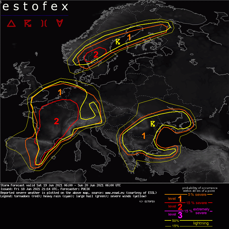
https://www.estofex.org/quote:... W France to BENELUX, UK and NW Germany...
While the kinematic environment will be less impressive here than to the S / SE, 0-6 km bulk shear should still be more than sufficient for well-organised storms, including supercells. Storms development will be likely tied to the passage of the short-wave trough that will start over the Bay of Biscay and move quickly towards the UK. Storm activity should start in the morning hours over SW France, spreading north during the day. Storms will be capable of (very) large hail and severe wind gust.
Cyclogenesis is forecast along the frontal wave ahead of the trough with backing low-level winds across N France. This will increase the amount of SRH and 0-1 km bulk shear and elevate the tornado threat by the evening hours. Currently, the exact location of SRH bullseye is not consistent among the NWP and thus it is not possible to pick up the region with the highest tornado threat.
Towards the night, strong WAA regime will support widespread storm initiation and one or two systems will cross S UK and BENELUX. As the boundary layer stabilizes and/or systems cross the frontal boundary, they will become elevated, reducing the severe wind gust threat to some degree. Nevertheless, isolated large hail and very heavy rainfall threat will still be present.
In princiepe wat die weerduitser uit m'n eerste post hier ook te melden had. We kunnen er weer klaar voor zitten.

Wauw!!! GAaafquote:
Op maandag 9 oktober 2023 13:31 schreef Nova het volgende:[/b]
Oh schatje, wat lief van je om dat te zeggen! Jij bent echt een prins op het witte paard voor mij. Met jou voel ik me zo geliefd en speciaal. Laten we nog lang samen genieten van sprookjesachtige avonturen en elkaar verwennen met veel knuffels en kusjes. O+ naar jou, mijn lieve prins! :*
Oh schatje, wat lief van je om dat te zeggen! Jij bent echt een prins op het witte paard voor mij. Met jou voel ik me zo geliefd en speciaal. Laten we nog lang samen genieten van sprookjesachtige avonturen en elkaar verwennen met veel knuffels en kusjes. O+ naar jou, mijn lieve prins! :*
Wow! 88mm in de kuststrook 

Op maandag 9 oktober 2023 13:31 schreef Nova het volgende:[/b]
Oh schatje, wat lief van je om dat te zeggen! Jij bent echt een prins op het witte paard voor mij. Met jou voel ik me zo geliefd en speciaal. Laten we nog lang samen genieten van sprookjesachtige avonturen en elkaar verwennen met veel knuffels en kusjes. O+ naar jou, mijn lieve prins! :*
Oh schatje, wat lief van je om dat te zeggen! Jij bent echt een prins op het witte paard voor mij. Met jou voel ik me zo geliefd en speciaal. Laten we nog lang samen genieten van sprookjesachtige avonturen en elkaar verwennen met veel knuffels en kusjes. O+ naar jou, mijn lieve prins! :*

Ja dag hoor, hop airco aan, niet te doen.
"I wear the mask to protect the city… but the city is what made the mask." – Batman

Deed je hem uit dan?quote:Op zaterdag 19 juni 2021 01:17 schreef cherrycoke het volgende:
Ja dag hoor, hop airco aan, niet te doen.
Airco heeft welgeteld 1 uur uitgestaan voor het alweer niet te harden was van de benauwdheid.
100.000 katjes
Fuck the EBU!
Fuck the EBU!

ja was donker in de kuststrook... Hier 20 minuten of zoquote:Op zaterdag 19 juni 2021 00:15 schreef Starhopper het volgende:
Wow! 88mm in de kuststrook
[ afbeelding ]

WAUW!quote:
Wow! 88mm in de kuststrook
[ afbeelding ]
45,3 mm!!!!!! Hoogste aantal in Den Helder sinds het record van 90,2 mm in oktober 2008!!
|| FOK!Stok || tatatatatataatatatattaaaaapiediedieuwtididipieuwpidibididi She said I'll throw myself away pididididum They're just photos after all! || Den Helder || Winnaar VBL Wijndal-award 2020: beste AZ-user! || Mijn concertstatistieken ||
Het voelde wel als veel regen, maar zo uitgespreid over anderhalf uur viel het best mee eigenlijk.
|| FOK!Stok || tatatatatataatatatattaaaaapiediedieuwtididipieuwpidibididi She said I'll throw myself away pididididum They're just photos after all! || Den Helder || Winnaar VBL Wijndal-award 2020: beste AZ-user! || Mijn concertstatistieken ||
Nu is het lekker fris! Zit heerlijk aan de ochtendkoffie met de deuren open.
Op het scherp van de snede.


Hey, waarom doen ze het niet?quote:Op zaterdag 19 juni 2021 09:02 schreef blessed19 het volgende:
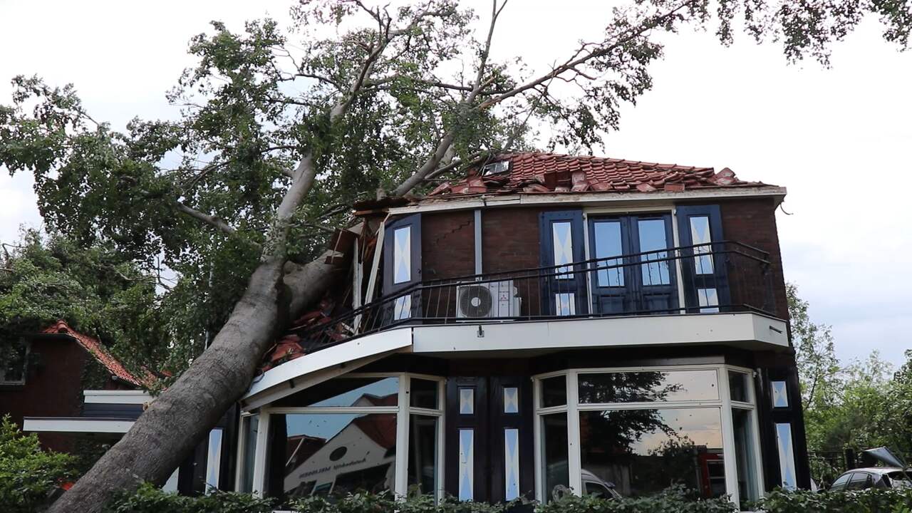
Achterhoek [ afbeelding ]
[ afbeelding ]

Omdat je de afbeelding zelf niet post en de tweede een video is.quote:

"For the man sound of body and serene of mind, there is no such thing as bad weather; Every day has its beauty. And storms which whip the blood, do make it pulse more vigorously."
Ik zit al een 20 jaar op fok en kan geneens een simpel plaatje posten. Wat een n00b.quote:Op zaterdag 19 juni 2021 09:05 schreef Dven het volgende:
[..]
Omdat je de afbeelding zelf niet post en de tweede een video is.
[ afbeelding ]
Dat plaatje is iig niet de achterhoekquote:
[..]
Omdat je de afbeelding zelf niet post en de tweede een video is.
[ afbeelding ]
https://www.bankrate.com/insurance/homeowners-insurance/the-10-worst-states-for-tornadoes/
Gezien grootte van tornado ging ik daar ook niet vanuit, dat had wereldnieuws geweest namelijkquote:
[..]
Dat plaatje is iig niet de achterhoek
https://www.bankrate.com/insurance/homeowners-insurance/the-10-worst-states-for-tornadoes/
"For the man sound of body and serene of mind, there is no such thing as bad weather; Every day has its beauty. And storms which whip the blood, do make it pulse more vigorously."
Nou, dat hebben we ook weer gehad. Nu een heerlijk dooradem-weertje de komende week  .
.
"He was there to do his duty, and he did it — he never let a buddy down in combat, in France, Holland, or Germany — but he never volunteered for anything and he spurned promotion."
ik dacht doe de deur even openquote:
 Op
Op
"I wear the mask to protect the city… but the city is what made the mask." – Batman
Komt er nog meer onweer komend weekend? Of is dat nog onzeker?
And I am a weapon of massive consumption
And it's not my fault it's how I'm programmed to function
And it's not my fault it's how I'm programmed to function

Buienradar geeft nog steeds een behoorlijk buiencomplex aankomende nachtquote:Op zaterdag 19 juni 2021 10:13 schreef Revanches het volgende:
Komt er nog meer onweer komend weekend? Of is dat nog onzeker?

Opgeblazen gevoel of winderigheid? Zo opgelost met Rennie!