WKN Weer, Klimaat en Natuurrampen
Lees alles over het onstuimige weer op onze planeet, volg orkanen en tornado's, zie hoe vulkanen uitbarsten en hoe Moeder Aarde beeft bij een aardbeving. Alles over de verwoestende kracht van onze planeet en tal van andere natuurverschijnselen.


Winter in noord Amerika
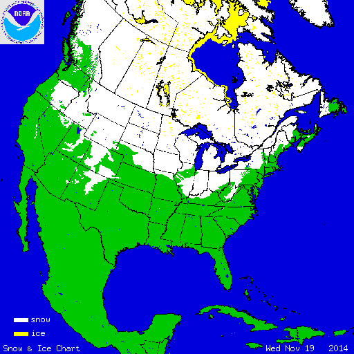
Eind augustus begint de kou op het noordelijk halfrond zich weer langzaam uit te breiden richting het zuiden. In het hoge noorden van Canada zakt de temperatuur alweer onder het vriespunt en valt alweer de eerste sneeuw. Afgelopen winter was streng en sneeuwrijk. De grote meren tussen Canada en de VS waren grotendeels bevroren.
De bedoeling van dit topic is om het nieuws rond de winter in noord Amerika te volgen. Nieuws, foto's, video's etc etc zijn hier welkom.
Winter in Canada
In de winter is het koud in het noorden en het midden. Temperaturen dalen daar gemakkelijk tot -30 graden. Op 1 februari werd in Snag de allerlaagste Canadese temperatuur bereikt van -62.8 graden. Alleen het uiterste westen heeft een mild klimaat. In Vancouver komt het minste vorst voor.
Noord Canada
Zuid Canada
Oost Canada
De noordoostelijke staten van de USA
De winter in New England staat bekend als een koude winter. De wind is in het winterhalfjaar noordwestelijk en droge arctische lucht uit Canada stroomt ver naar het zuiden. Deze kou-invallen gaan soms gepaard met blizzards. Opdringende warme lucht uit het zuiden zorgt af en toe voor flinke ijzel.
Gemiddeld vriest het bij de Canadese grens in januari zo'n -13 graden. In New Jersey vriest het zo'n 5 graden. In het noordoostelijke puntje van New England daalt in januari de thermometer gemiddeld elke nacht tot -19 graden. De extremen in het gebied liegen er ook niet om. Op 19 januari werd het in Van Buren (Maine) -44,4 graden. Old Forge (New York) mat op 18 februari 1979 zelfs een minimum van -46,7 graden. Het zeewater daalt in januari en februari tot +4 graden in zowel Boston als in New York.
De zuidoostelijke staten van de USA
In de winter komt de gemiddelde kou tot Atlanta. In Maryland, Virginia, de Appalachen en de hoger gelegen staten als Kentucky vriest het veelvuldig. De ergste kou vinden we nog noordelijker in Michigan en Ontario. In West Virginia vinden we de allerlaagste temperatuur van het gebied terug. Op 30 december 1917 daalde in Lewisburg de thermometer tot -38,3 graden.
Het gebied langs de Golf van Mexico beleeft een relatief milde en korte winter. Toch kan het hier soms flink vriezen. Neem bijvoorbeeld de -28 graden die in Corinth (Mississippi) op 30 januari 1966 werd gemeten. In Florida neemt de invloed van de oceaan toe. Dit is vooral merkbaar aan de gemiddelde nachttemperatuur in het zuiden. In zeer uitzonderlijke situatie vriest het hier of valt er sneeuw. Op de Key's komt de temperatuur nooit onder nul. De allerlaagste temperatuur in Florida bedroeg -18,9 graden en werd gemeten in Tallahassee.
De staten Virginia, West Virginia en Maryland krijgen in de winter soms te maken met sneeuwstormen. Deze staan bekend als Nor'easters en komen oktober en april. Ze zijn berucht om de grote hoeveelheid sneeuw, regen en de flinke wind.
Een Nor'easter komt voor als een lagedrukgebied warme vochtige subtropische lucht uit de Golf van Mexico naar het noorden voert. De lucht wordt vermengd met vochtige lucht uit de Atlantische Oceaan. Een hogedrukgebied boven Canada biedt tegenwicht en stuwt arctische lucht naar het zuiden. Daar waar de luchtsoorten bij elkaar komen, ontstaat hevige neerslag.
De meest actieve Nor'easter is de sneeuwstorm die naar het oosten trekt en de straalstroom volgt. Vooral Washington DC, Philadelphia, New York City en Boston worden dan getroffen en krijgen grote hoeveelheden regen en sneeuw te verwerken.
Het midden van de Verenigde Staten
De winters in het noorden zijn streng. Bismarck in North Dakota heeft in januari een gemiddelde temperatuur van -12,7 graden. International Falls op de grens van Canada en Minnesota heeft zelfs een gemiddelde januari-temperatuur van -17,2 graden. De nachtelijke temperaturen bedragen hier gemiddeld -23,3 graden en de dagtemperatuur -11,2 graden.
De staten langs de Canadese grens en de Grote Meren krijgen ook in de winter vaak te maken met 'blizzards', die zeer koude lucht aanvoeren vanuit het arctische Canada. Het gebied is dan bedekt met een sneeuwlaag. Veel is dit niet. In januari valt er slechts enkele tientallen millimeters neerslag.
Veel nachten verlopen helder en de aanwezigheid van een sneeuwdek helpt mee aan een lage temperatuur. De allerlaagste temperatuur in North Dakota werd gemeten op 15 februari 1936. In Parshall werd het -51,1 graden. Op 2 februari 1996 gebeurde hetzelfde in Towar, Minnesota.
Naar het zuiden neemt de strengheid van de winter af. Tot in Kansas is de gemiddelde januaritemperatuur onder nul. In Texas loopt deze snel op. Niet alleen de zuidelijke ligging, maar ook de aanwezigheid van de Golf van Mexico speelt daarbij een rol. In Brownsville op de grens met Mexico is het in januari overdag 20,5 graden en incidenteel boven de 33 graden.
Toch krijgen relatief zuidelijk gelegen gebieden 's winters soms te maken met extreme koude situaties, doordat luchtstromen uit het hoge noorden van Canada hun weg zuidwaarts zoeken tussen de Rocky Mountains en de Appalachen. Zo was het in het ogenschijnlijk warme Texas op 3 februari 1933 in Seminole -30,6 graden.
Westen van de Verenigde Staten
In de winter heerst de meeste kou in de hoger gelegen delen van de Rocky Mountains. Arctische lucht uit Canada zorgt voor strenge winters in het noorden, zoals in Montana, Wyoming en Colorado. In Montana richt de snijdend koude wind geregeld slachtingen aan onder de veestapel. De allerlaagste temperatuur in Montana werd gemeten op 20 januari 1954. Op Rogers Pass werd het toen -56,7 graden onder nul.
In Wyoming waar ook lange strenge winters voorkomen, staat het minimumrecord op bijna -53 graden vorst. Het berggebied van Idao, Utah en Colorado is koud en sneeuwachtig. Vooral in Colorado valt veel sneeuw. Temperaturen tot onder de -50 graden zijn incidenteel mogelijk. De hoogvlakte van Nevada is eveneens koud. In Ely op 1900 meter hoogte vriest het in januari 's nachts zo'n -12,5 graden. Dit wordt tevens veroorzaakt door de vele heldere nachten in het gebied.
Warmer is het in Washington en Oregon. Het kan hier behoorlijk vriezen, maar aan zee is de winter relatief mild. De regen valt vooral tussen oktober en april. In de bergen gaat het dan om sneeuw en worden wegen afgesloten.
In het zuidwesten van Californië blijft het winters klimaat aangenaam en vriest het zelden. Het is daar dan ook regentijd. Toch kan de winter flink uithalen. Vooral in de Sierra Nevada is dat het geval. De allerlaagste temperatuur in Californië die is gemeten bedraagt -42,8 graden. In New Mexico tenslotte zijn de winters koel maar niet extreem koud.
Alaska
In de noordelijke Amerikaanse staat Alaska heersen verschillende klimaten. Zeestromingen, bergruggen en een lage zonnestand bepalen voornamelijk het klimaat. In het noorden komen poolwoestijnen voor, in het zuiden heerst een mild klimaat dat vergelijkbaar is met Nederland.
Bron:
De bedoeling van dit Topic is om het winterweer in Noord Amerika te volgen.
B.v. via onderstaande site's
Weather Channel
Accuweather
Winter Weather cnn
Google News
US wind kaart
Great Lakes map
vorige delen:
Topicreeks: Winter in Noord Amerika
WKN / Winter in VS 2012/2013 - Meer sneeuw en storm op komst
WKN / Winter in noord Amerika 2013/2014
verwante topics
WKN / Hurricane Season 2014: Orkanen & Cyclonen
WKN / Poolkappen, IJsbergen en Gletsjers #4
WKN / [ACTUEEL] Tornado's VS #23 Nieuwe seizoen van start
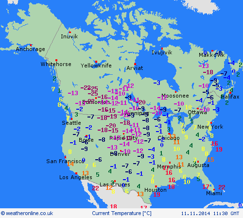
De huidige temperaturen in Canada
De huidige temperaturen in de V.S.
De huidige temperaturen in Alaska
Kaartje waarop de sneeuwhoogte en uitbreiding van het noordpoolijs is te volgen.
[ Bericht 0% gewijzigd door #ANONIEM op 01-09-2014 12:31:58 ]

Eind augustus begint de kou op het noordelijk halfrond zich weer langzaam uit te breiden richting het zuiden. In het hoge noorden van Canada zakt de temperatuur alweer onder het vriespunt en valt alweer de eerste sneeuw. Afgelopen winter was streng en sneeuwrijk. De grote meren tussen Canada en de VS waren grotendeels bevroren.
De bedoeling van dit topic is om het nieuws rond de winter in noord Amerika te volgen. Nieuws, foto's, video's etc etc zijn hier welkom.
Winter in Canada
In de winter is het koud in het noorden en het midden. Temperaturen dalen daar gemakkelijk tot -30 graden. Op 1 februari werd in Snag de allerlaagste Canadese temperatuur bereikt van -62.8 graden. Alleen het uiterste westen heeft een mild klimaat. In Vancouver komt het minste vorst voor.
Noord Canada
Zuid Canada
Oost Canada
De noordoostelijke staten van de USA
De winter in New England staat bekend als een koude winter. De wind is in het winterhalfjaar noordwestelijk en droge arctische lucht uit Canada stroomt ver naar het zuiden. Deze kou-invallen gaan soms gepaard met blizzards. Opdringende warme lucht uit het zuiden zorgt af en toe voor flinke ijzel.
Gemiddeld vriest het bij de Canadese grens in januari zo'n -13 graden. In New Jersey vriest het zo'n 5 graden. In het noordoostelijke puntje van New England daalt in januari de thermometer gemiddeld elke nacht tot -19 graden. De extremen in het gebied liegen er ook niet om. Op 19 januari werd het in Van Buren (Maine) -44,4 graden. Old Forge (New York) mat op 18 februari 1979 zelfs een minimum van -46,7 graden. Het zeewater daalt in januari en februari tot +4 graden in zowel Boston als in New York.
De zuidoostelijke staten van de USA
In de winter komt de gemiddelde kou tot Atlanta. In Maryland, Virginia, de Appalachen en de hoger gelegen staten als Kentucky vriest het veelvuldig. De ergste kou vinden we nog noordelijker in Michigan en Ontario. In West Virginia vinden we de allerlaagste temperatuur van het gebied terug. Op 30 december 1917 daalde in Lewisburg de thermometer tot -38,3 graden.
Het gebied langs de Golf van Mexico beleeft een relatief milde en korte winter. Toch kan het hier soms flink vriezen. Neem bijvoorbeeld de -28 graden die in Corinth (Mississippi) op 30 januari 1966 werd gemeten. In Florida neemt de invloed van de oceaan toe. Dit is vooral merkbaar aan de gemiddelde nachttemperatuur in het zuiden. In zeer uitzonderlijke situatie vriest het hier of valt er sneeuw. Op de Key's komt de temperatuur nooit onder nul. De allerlaagste temperatuur in Florida bedroeg -18,9 graden en werd gemeten in Tallahassee.
De staten Virginia, West Virginia en Maryland krijgen in de winter soms te maken met sneeuwstormen. Deze staan bekend als Nor'easters en komen oktober en april. Ze zijn berucht om de grote hoeveelheid sneeuw, regen en de flinke wind.
Een Nor'easter komt voor als een lagedrukgebied warme vochtige subtropische lucht uit de Golf van Mexico naar het noorden voert. De lucht wordt vermengd met vochtige lucht uit de Atlantische Oceaan. Een hogedrukgebied boven Canada biedt tegenwicht en stuwt arctische lucht naar het zuiden. Daar waar de luchtsoorten bij elkaar komen, ontstaat hevige neerslag.
De meest actieve Nor'easter is de sneeuwstorm die naar het oosten trekt en de straalstroom volgt. Vooral Washington DC, Philadelphia, New York City en Boston worden dan getroffen en krijgen grote hoeveelheden regen en sneeuw te verwerken.
Het midden van de Verenigde Staten
De winters in het noorden zijn streng. Bismarck in North Dakota heeft in januari een gemiddelde temperatuur van -12,7 graden. International Falls op de grens van Canada en Minnesota heeft zelfs een gemiddelde januari-temperatuur van -17,2 graden. De nachtelijke temperaturen bedragen hier gemiddeld -23,3 graden en de dagtemperatuur -11,2 graden.
De staten langs de Canadese grens en de Grote Meren krijgen ook in de winter vaak te maken met 'blizzards', die zeer koude lucht aanvoeren vanuit het arctische Canada. Het gebied is dan bedekt met een sneeuwlaag. Veel is dit niet. In januari valt er slechts enkele tientallen millimeters neerslag.
Veel nachten verlopen helder en de aanwezigheid van een sneeuwdek helpt mee aan een lage temperatuur. De allerlaagste temperatuur in North Dakota werd gemeten op 15 februari 1936. In Parshall werd het -51,1 graden. Op 2 februari 1996 gebeurde hetzelfde in Towar, Minnesota.
Naar het zuiden neemt de strengheid van de winter af. Tot in Kansas is de gemiddelde januaritemperatuur onder nul. In Texas loopt deze snel op. Niet alleen de zuidelijke ligging, maar ook de aanwezigheid van de Golf van Mexico speelt daarbij een rol. In Brownsville op de grens met Mexico is het in januari overdag 20,5 graden en incidenteel boven de 33 graden.
Toch krijgen relatief zuidelijk gelegen gebieden 's winters soms te maken met extreme koude situaties, doordat luchtstromen uit het hoge noorden van Canada hun weg zuidwaarts zoeken tussen de Rocky Mountains en de Appalachen. Zo was het in het ogenschijnlijk warme Texas op 3 februari 1933 in Seminole -30,6 graden.
Westen van de Verenigde Staten
In de winter heerst de meeste kou in de hoger gelegen delen van de Rocky Mountains. Arctische lucht uit Canada zorgt voor strenge winters in het noorden, zoals in Montana, Wyoming en Colorado. In Montana richt de snijdend koude wind geregeld slachtingen aan onder de veestapel. De allerlaagste temperatuur in Montana werd gemeten op 20 januari 1954. Op Rogers Pass werd het toen -56,7 graden onder nul.
In Wyoming waar ook lange strenge winters voorkomen, staat het minimumrecord op bijna -53 graden vorst. Het berggebied van Idao, Utah en Colorado is koud en sneeuwachtig. Vooral in Colorado valt veel sneeuw. Temperaturen tot onder de -50 graden zijn incidenteel mogelijk. De hoogvlakte van Nevada is eveneens koud. In Ely op 1900 meter hoogte vriest het in januari 's nachts zo'n -12,5 graden. Dit wordt tevens veroorzaakt door de vele heldere nachten in het gebied.
Warmer is het in Washington en Oregon. Het kan hier behoorlijk vriezen, maar aan zee is de winter relatief mild. De regen valt vooral tussen oktober en april. In de bergen gaat het dan om sneeuw en worden wegen afgesloten.
In het zuidwesten van Californië blijft het winters klimaat aangenaam en vriest het zelden. Het is daar dan ook regentijd. Toch kan de winter flink uithalen. Vooral in de Sierra Nevada is dat het geval. De allerlaagste temperatuur in Californië die is gemeten bedraagt -42,8 graden. In New Mexico tenslotte zijn de winters koel maar niet extreem koud.

Alaska
In de noordelijke Amerikaanse staat Alaska heersen verschillende klimaten. Zeestromingen, bergruggen en een lage zonnestand bepalen voornamelijk het klimaat. In het noorden komen poolwoestijnen voor, in het zuiden heerst een mild klimaat dat vergelijkbaar is met Nederland.
Bron:
De bedoeling van dit Topic is om het winterweer in Noord Amerika te volgen.
B.v. via onderstaande site's
Weather Channel
Accuweather
Winter Weather cnn
Google News
US wind kaart
Great Lakes map
vorige delen:
Topicreeks: Winter in Noord Amerika
WKN / Winter in VS 2012/2013 - Meer sneeuw en storm op komst
WKN / Winter in noord Amerika 2013/2014
verwante topics
WKN / Hurricane Season 2014: Orkanen & Cyclonen
WKN / Poolkappen, IJsbergen en Gletsjers #4
WKN / [ACTUEEL] Tornado's VS #23 Nieuwe seizoen van start
De huidige temperaturen in Canada

De huidige temperaturen in de V.S.

De huidige temperaturen in Alaska

Kaartje waarop de sneeuwhoogte en uitbreiding van het noordpoolijs is te volgen.

[ Bericht 0% gewijzigd door #ANONIEM op 01-09-2014 12:31:58 ]
Nice. Winter komt eraan 
Hoe weerhoudt de huidige zee-ijsbedekking zich tot in voorgaande jaren?
Hoe weerhoudt de huidige zee-ijsbedekking zich tot in voorgaande jaren?
"For the man sound of body and serene of mind, there is no such thing as bad weather; Every day has its beauty. And storms which whip the blood, do make it pulse more vigorously."

Dat is meer dan de afgelopen jaren.quote:Op maandag 1 september 2014 12:53 schreef Dven het volgende:
Nice. Winter komt eraan
Hoe weerhoudt de huidige zee-ijsbedekking zich tot in voorgaande jaren?
WKN / Poolkappen, IJsbergen en Gletsjers #4
quote:Snow fell on the Labor Day weekend in parts of northern Alaska and Wyoming, providing a gentle reminder that summer is on its last legs.
Snow levels lowered to 9,000 feet in northwest Wyoming.
A dusting of snow was captured on Wyoming DOT cams Sunday morning northwest of Dubois, Wyoming along U.S. 26 and 287 at an elevation of 9,500 feet and coated the top of Grand Targhee Resort Sunday afternoon, according to the National Weather Service office in Riverton, Wyoming.

http://www.weather.com/ne(...)ska-wyoming-20140901
Dat ziet er verdomde koud uitquote:
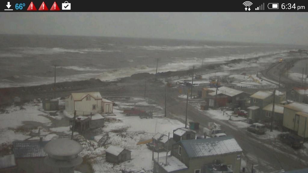
Noordelijkste puntje van Alaska (Barrow).
[ afbeelding ]
"For the man sound of body and serene of mind, there is no such thing as bad weather; Every day has its beauty. And storms which whip the blood, do make it pulse more vigorously."
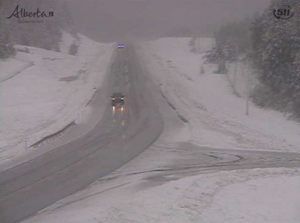
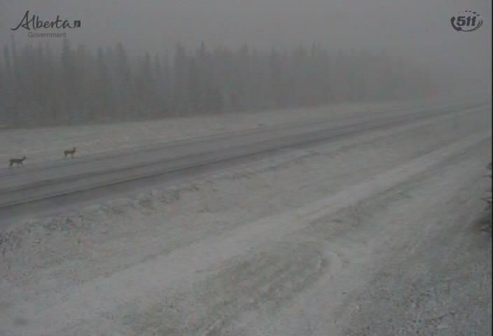
Zuiden van Alberta (Canada).
CALGARY- Summer isn’t even over yet, but snow has already fallen in some parts of southern Alberta.
Areas south of Chain Lakes got a sprinkling of snow on Wednesday morning, much to the surprise of many who are still trying to enjoy the last days before fall.
“It seems like it’s going to be an early winter,” said Michael Kosolofski. “The geese are already flying south, and it seems like it’s colder than normal for September.”
Highway cameras also captured photos of snow along Highway 22X, and ski resorts such as Sunshine Village and Fernie Alpine Resort have also reported snow falls.
“Being here from Australia, it was absolutely amazing to see it,” said Linda Ball. “We don’t have snow in Queensland!”
The weather is expected to make a huge turnaround over the next few days, with a high of 24 degrees forecast for Sunday.
http://globalnews.ca/news(...)ar&utm_campaign=2014
[ Bericht 82% gewijzigd door #ANONIEM op 04-09-2014 12:37:46 ]
Nog een foto van de eerste sneeuw in Barrow (Alaska).
[ Bericht 71% gewijzigd door #ANONIEM op 04-09-2014 13:35:21 ]
quote:Barrow, Alaska, was blanketed by its first significant snowfall of the season Tuesday, turning the town into a winter wonderland just one day after Labor Day.
Snow covers Barrow, Alaska, on Sep. 2, 2014 in this view from the Barrow Sea Ice Webcam. (Univ. of Alaska-Fairbanks Geophysical Institute)
Officially, 4.4 inches of snow fell Tuesday in America's northernmost city, about 350 miles north of the Arctic Circle (2012 population: 4,346).
Tuesday tied the third heaviest September calendar-day snow on record in Barrow. Only Sept. 13, 1987 (5.1 inches) and Setp. 9, 2003 (4.7 inches) were heavier. Tuesday was its heaviest calendar-day snow on record anytime from August through the first week of September.
Dating to 1922, at least a trace of snow has been recorded at least once on each calendar day in Barrow. This summer, a half inch of snow fell in the city from Aug. 29-30, and 0.9 inches of snow was measured on July 23-24.
http://www.weather.com/ne(...)ard-warning-20140903
[ Bericht 71% gewijzigd door #ANONIEM op 04-09-2014 13:35:21 ]
Ha ja de winter staat alweer voor de deur! Nog geen sneeuw hier (midden/zuid Saskatchewan, Canada) maar volgende week neemt de temperatuur een duik van +25 naar +6 binnen twee dagen met nachttemperaturen net onder het vriespunt. Dat is behoorlijk koud voor de tijd van het jaar.
Al vind ik het koude (en zonnige) weer prima in de winter, ik hoop dat de -47 van afgelopen winter niet herhaald wordt!
Al vind ik het koude (en zonnige) weer prima in de winter, ik hoop dat de -47 van afgelopen winter niet herhaald wordt!
Dat zal wennen worden.quote:
Ha ja de winter staat alweer voor de deur! Nog geen sneeuw hier (midden/zuid Saskatchewan, Canada) maar volgende week neemt de temperatuur een duik van +25 naar +6 binnen twee dagen met nachttemperaturen net onder het vriespunt. Dat is behoorlijk koud voor de tijd van het jaar.
Al vind ik het koude (en zonnige) weer prima in de winter, ik hoop dat de -47 van afgelopen winter niet herhaald wordt!
Foto's zijn altijd welkom.

Als er iets foto-waardigs komt doe ik dat zekerquote:Op donderdag 4 september 2014 19:34 schreef aloa het volgende:
[..]
Dat zal wennen worden.
Foto's zijn altijd welkom.
Dat moet goed komen. Waar je zit is het volop winter volgens mij. Hoeveel maanden sneeuw heb je daar?quote:Op donderdag 4 september 2014 21:04 schreef jeroen1976 het volgende:
[..]
Als er iets foto-waardigs komt doe ik dat zeker
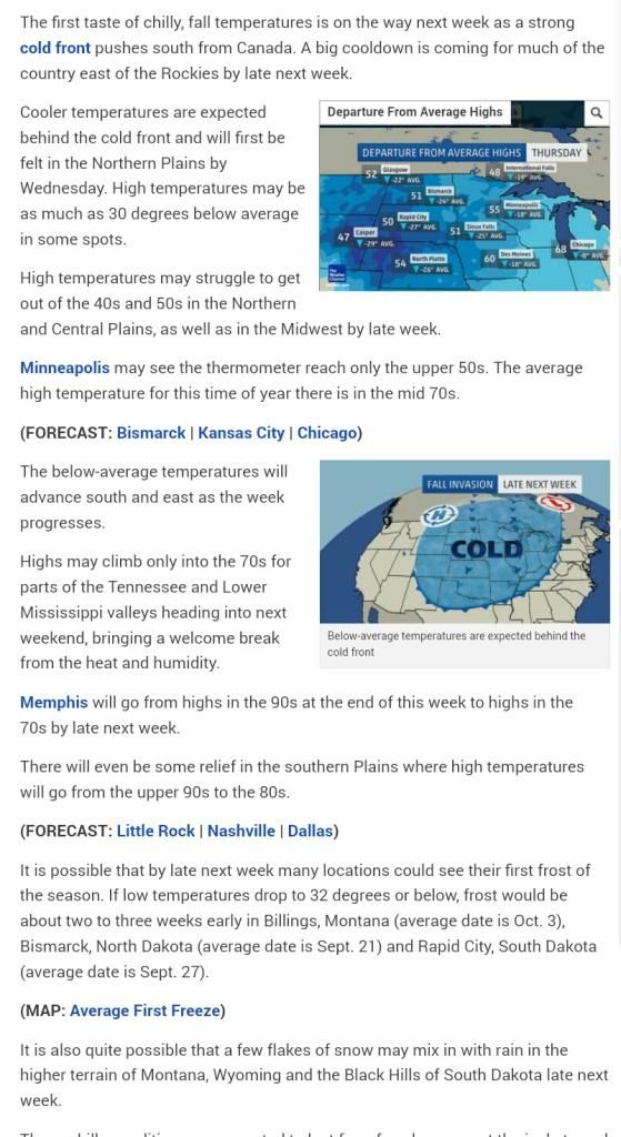
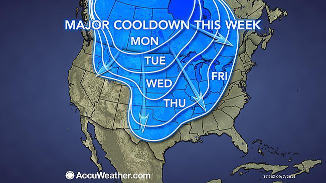
September Snow to Fall Over Northern Plains Tuesday
The first frost and snowfall of the year will arrive over the northern Plains before the middle of the week.
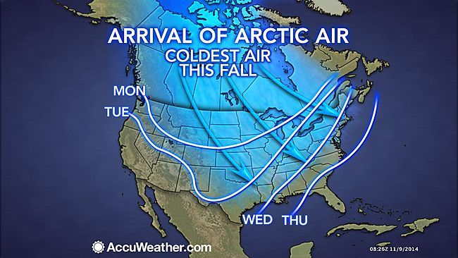
"A major cold front will push southward through the Prairies Monday with a strong, Arctic high pressure system building in behind it," said AccuWeather Canada Weather Expert Brett Anderson.
The air behind this front will be cold enough for several inches of snow to fall over the Canadian Rockies and even in cities such as Calgary and Edmonton on Monday afternoon into Tuesday evening.
Snow is then forecast to make an appearance across Montana and into North Dakota on Tuesday night, although little is expected in terms of snow accumulation.
"The chilliest air since last spring will push southward from Canada and across the northern and central Plains, Midwest and the eastern slopes of the Rockies, prior to the middle of September," said AccuWeather Senior Meteorologist Alex Sosnowski.
This chilly air mass will continue to expand south and east throughout the rest of the week, but the coldest air will remain locked up over the Canadian Prairies and northern Plains.
The first frost and snowfall of the year will arrive over the northern Plains before the middle of the week.
"A major cold front will push southward through the Prairies Monday with a strong, Arctic high pressure system building in behind it," said AccuWeather Canada Weather Expert Brett Anderson.
The air behind this front will be cold enough for several inches of snow to fall over the Canadian Rockies and even in cities such as Calgary and Edmonton on Monday afternoon into Tuesday evening.
Snow is then forecast to make an appearance across Montana and into North Dakota on Tuesday night, although little is expected in terms of snow accumulation.
"The chilliest air since last spring will push southward from Canada and across the northern and central Plains, Midwest and the eastern slopes of the Rockies, prior to the middle of September," said AccuWeather Senior Meteorologist Alex Sosnowski.
This chilly air mass will continue to expand south and east throughout the rest of the week, but the coldest air will remain locked up over the Canadian Prairies and northern Plains.
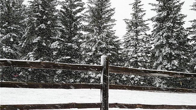
Alberta Canada.
It IS still technically summer, correct? #yyc RT @c_of_red @Lyndsay_CTV Snow falling in Calgary, AB this morning http://t.co/AMxdlIrVS8
[ Bericht 22% gewijzigd door #ANONIEM op 08-09-2014 17:09:19 ]
It IS still technically summer, correct? #yyc RT @c_of_red @Lyndsay_CTV Snow falling in Calgary, AB this morning http://t.co/AMxdlIrVS8
[ Bericht 22% gewijzigd door #ANONIEM op 08-09-2014 17:09:19 ]
Meestal van half oktober tot eind maart, dus lang genoegquote:
[..]
Dat moet goed komen. Waar je zit is het volop winter volgens mij. Hoeveel maanden sneeuw heb je daar?
Lake Louise 1600 m (Canada) eerste sneeuw voor dit seizoen.
De kou zakt ook af richting de VS.
[ Bericht 0% gewijzigd door #ANONIEM op 09-09-2014 16:48:42 ]
De kou zakt ook af richting de VS.
quote:The first frost and snowfall of the year will arrive over the northern Plains of the United States before the middle of the week.
"A major cold front pushed southward through the Canada Prairies Monday with a strong, Arctic high pressure system building in behind it," said AccuWeather Canada Weather Expert Brett Anderson.
The air behind this front will be cold enough for several inches of snow to fall over the Canadian Rockies and even in cities such as Calgary and Edmonton on into Tuesday evening.
Snow and cold air are then forecast to make an appearance across Montana and into portions of North Dakota, South Dakota and Wyoming on Tuesday night, although little is expected in terms of snow accumulation.
http://www.accuweather.co(...)all-over-no/33659944

[ Bericht 0% gewijzigd door #ANONIEM op 09-09-2014 16:48:42 ]
Lyndsay Morrison
Summer Snowman .. in a bikini! Still can't believe that THIS MUCH snow fell in Calgary .. on Sept 8th. #abstorm #yyc http://t.co/mZLQBsLkn2
Summer Snowman .. in a bikini! Still can't believe that THIS MUCH snow fell in Calgary .. on Sept 8th. #abstorm #yyc http://t.co/mZLQBsLkn2
Het is iets te lang, vooral omdat het voorjaar zo lang uitblijft en januari/februari het koudst zijn. Maar zodra het opwarmt voelt een -5 als +15 en loop ik meestal al zonder jas in een t-shirt buiten.quote:
Ik vind -15/-20 met de hele dag zon wel een stuk prettiger dan het meestal grijze regenachtige weer tijdens de Nederlandse winters.
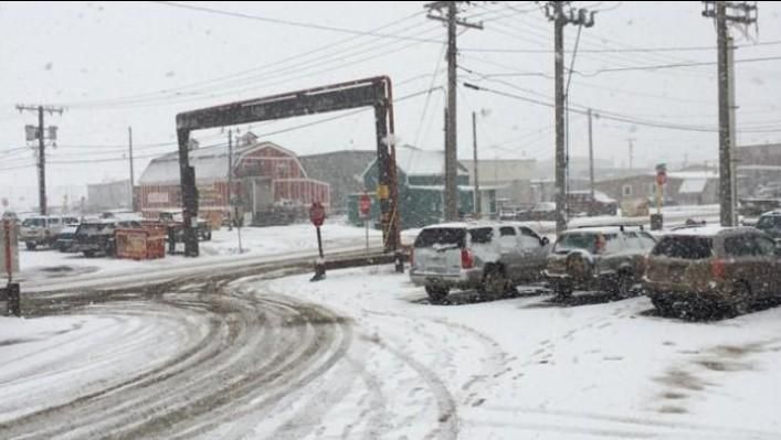
Sneeuw in Alberta Canada.
Twitter:
Twitter:
quote:Unbelievable Alberta snowfall amounts! RT @DuBeL_JaY: 15" one hour west of Sundre. #winning http://t.co/V6t9TqW3nM
Snowflakes are forecast to fall around Denver with a coating possible in the foothills and areas north of the metro area during Thursday night into Friday.
The outbreak will bring a freeze to portions of the northern High Plains and the risk of frost to areas farther to the east and south over the northern and central Plains.
According to AccuWeather Senior Meteorologist Dale Mohler, "While a freeze will not reach areas where major crops have not reached maturity, scattered frost will be a concern for backyard gardens over the North Central states."
@Accuweather
The outbreak will bring a freeze to portions of the northern High Plains and the risk of frost to areas farther to the east and south over the northern and central Plains.
According to AccuWeather Senior Meteorologist Dale Mohler, "While a freeze will not reach areas where major crops have not reached maturity, scattered frost will be a concern for backyard gardens over the North Central states."

@Accuweather

Heavy snowfall Wednesday night and Thursday morning covered parts of Montana, Wyoming and western South Dakota.
As of Thursday morning, up to 6-8 inches accumulated on portions of the Black Hills in South Dakota, and Cut Bank and Lewistown in Montana had their first snowfall of the season. The early snowfall has caused over 30,000 power outages in Calgary, Alberta, and threatened to cause power outages in the Rockies and northern Plains of the United States.
AccuWeather Senior Meteorologist Brett Anderson said "Many times when we see an outbreak like this, this early in the season, it doesn't last and will go back to normal pretty quickly."
Accuweather

De tering, dat ziet er allemaal koud uit 
"The only sight worse than a sad dwarf is a very sad dwarf"
"Met dubbel s welteverstaan"
"Met dubbel s welteverstaan"

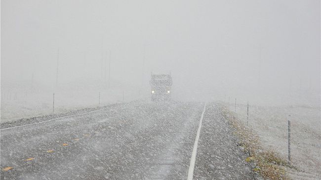
De winter wilt hier nog niet op gang komen, normaal hebben we rond deze tijd al sneeuw gezien maar vandaag is het 33 graden!
Het is nog steeds vrij vroeg toch? Het is nog geen oktober...quote:Op donderdag 25 september 2014 20:42 schreef jeroen1976 het volgende:
De winter wilt hier nog niet op gang komen, normaal hebben we rond deze tijd al sneeuw gezien maar vandaag is het 33 graden!
Klopt, maar meestal hebben we hier wel al een aantal witte ochtenden gezien tegen het einde van September. Vorige week is het een aantal nachten -5 graden geweest en het gras en plasjes water waren bevroren.quote:
[..]
Het is nog steeds vrij vroeg toch? Het is nog geen oktober...
Met de +34 op dit moment is het vandaag officieel een warmte record in zuid Saskatchewan, het vorige record was +31 in 1997.
En het was vandaag -17 in 1928 dus het kan zeker al winter zijn hier rond deze tijd van het jaar!

Eindelijk een beetje vrieskou hier, -2 op dit moment (13:00) met een windchill van -7. Toch maar m'n jas aan doen voor lunch. Binnen een uurtje gaat er sneeuw vallen!
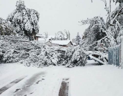
GFS verwacht meer dan een halve meter sneeuw. In combinatie met de storm kan dat voor behoorlijk wat overlast zorgen.


.quote:Op vrijdag 31 oktober 2014 03:09 schreef aloa het volgende:
GFS verwacht meer dan een halve meter sneeuw. In combinatie met de storm kan dat voor behoorlijk wat overlast zorgen.
[ afbeelding ]
Jammer dat we dat hier niet hebben
ph'nglui mglw'nafh Cthulhu R'lyeh wgah'nagl fhtagn

Bronquote:Typhoon Nuri forecast to kick-start a parade of cold outbreaks in Eastern U.S.
Powerful Typhoon Nuri is expected to generate a ripple effect of chilly U.S. weather in November, after the storm deepens to potentially record-setting pressures in the Bering Sea later this week.
Typhoon Nuri has weakened since Monday, now the equivalent of a category 4 hurricane. Remarkably, the typhoon remained a category 5 for 24 hours, and maintained its 180 mph winds for at least 18 hours. Nuri is now tied with Typhoon Vongfong as the strongest storm of 2014.
But Nuri’s superlatives likely won’t end there. Over the next few days, Nuri is forecast to track north through the West Pacific, losing its tropical cyclone characteristics, and interacting with a strong jet stream. By the time the low pressure system reaches the Bering Sea, west of Alaska, it is forecast to have deepened to a pressure less than 920 mb — on par with some of the deepest cyclones on record. The lower the pressure, the more intense the storm is.
On Monday night, the European model was forecasting the cyclone to drop 36 mb in 18 hours to an incredible low pressure of 916 mb. This would likely be the lowest pressure ever recorded in the Bering Sea — the previous record for Alaska is 927 mb at Dutch Harbor in 1977. It would also come very close to the lowest extratropical pressure on record for any location, which is 913 mb, set in the North Atlantic in 1993.
Combined with some other atmospheric patterns that favor cold weather in the eastern U.S., Nuri’s extremely low pressure is poised to kick-start a domino effect on weather in the Northern Hemisphere over the next few weeks. In particular, it will spur a parade of cold air outbreaks across the central and eastern U.S. in November.
The storm’s deep low pressure will build a strong ridge in the eastern Pacific and over western North America. This, in turn, will force cold, Arctic air to surge south in the central and eastern U.S. over the next few weeks.
Arctic Oscillation forecasts also warn of cold times to come. The Arctic Oscillation (AO) is an indicator of the strength of the polar jet stream, which can effect how much Arctic air reaches the U.S. A positive AO suggests that cold, Arctic air will stay north. A negative AO, or weaker polar jet stream, opens the door for that cold air to spill south into the lower 48. Global models are predicting a dramatic shift into negative territory for the AO over the next week.
The GFS forecast of the Arctic Oscillation through November 12 shows a dramatic dive into negative territory, opening the door for cold air outbreaks across the U.S. (weatherbell.com)
GFS forecast of the Arctic Oscillation. (Weatherbell.com)
“The typhoon does appear to be contributing to the amplifying pattern by phasing with a trough coming off of East Asia,” said CWG’s Matt Rogers. “Amplifying that trough in turn amplifies more ridging downstream over the North Pacific toward Alaska.”
In addition to the powerful Bering Sea storm, favorable activity in the tropics and a warm pattern in the very high levels of the atmosphere are likely playing a part in the AO’s plunge to negative. All of these factors are expected to unite and deliver chilly November temperatures to the eastern U.S. The good news is that while this pattern does favor cold air outbreaks, we will have periods of warmer weather in between.


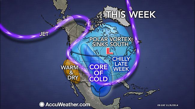
As the polar vortex gets displaced to the south, the door will open for arctic air to plunge over the most of the United States as the new week progresses.
Only the Southwest, Hawaii, Alaska and South Florida will escape the grip of the upcoming arctic blast that the polar vortex can be blamed for.
"The polar vortex is a large pocket of very cold air, typically the coldest air in the Northern Hemisphere, which sits over the polar region," stated AccuWeather.com Senior Meteorologist Alex Sosnowski.
"Occasionally, this pocket of very cold air can get dislodged farther south than normal, leading to cold outbreaks in Canada and the U.S."
Accuweather: Heavy snow on I-15 near Monida, MT, Idaho DOT webcam shows: http://t.co/gkYxRmg6TG Radar: http://t.co/mUwPtD7na6
Hier in Denver, Colorado is de temperatuur zojuist in 2 uur tijd van 15 naar 0 graden gedaald, en is nog steeds dalende. De eerste vlokjes sneeuw beginnen nu ook te vallen. Sommige mensen in korte broek en t-shirt zijn totaal verrast, maar het was gisteren dan ook nog 23 graden.
Bizar hoe snel het weer kan omslaan, maar ik geniet er dest te meer van
Bizar hoe snel het weer kan omslaan, maar ik geniet er dest te meer van
Bizar!quote:
Hier in Denver, Colorado is de temperatuur zojuist in 2 uur tijd van 15 naar 0 graden gedaald, en is nog steeds dalende. De eerste vlokjes sneeuw beginnen nu ook te vallen. Sommige mensen in korte broek en t-shirt zijn totaal verrast, maar het was gisteren dan ook nog 23 graden.
Bizar hoe snel het weer kan omslaan, maar ik geniet er dest te meer van
Vandaag is het kwik hier in Denver (of iets ten westen van Denver om precies te zijn) niet boven de -15 graden C uitgekomen. Daarbij is er ook al ruim 20cm sneeuw gevallen, heerlijk winterweer! 

Krijgt Californië al meer neerslag eigenlijk? Of houdt de droogte gewoon aan?
ph'nglui mglw'nafh Cthulhu R'lyeh wgah'nagl fhtagn

Bozeman !
Hoe verzinnen ze het
Hoe verzinnen ze het
quote:Winterstorm Bozeman forecast
Winter Storm Bozeman is poised to deliver a swath of snow from parts of Oregon and Washington to parts of Idaho, northern Nevada, Utah, Wyoming and Colorado through Saturday.
In fact, this may be one of the earliest snowfalls on record in the Portland, Oregon metro area
A storm system began moving into the Pacific Northwest on Wednesday night. It is transporting mild, moist Pacific air over the shallow, cold air mass near the ground. This will result in an unusually early spell of winterlike weather for the region. In fact, winter storm watches, warnings and advisories have already been issued for much of the Oregon, Idaho, and southern Washington state area. In addition, due to the threat of extremely gusty winds as well as wind-blown snow, blizzard warnings have been issued for the western Columbia River Gorge.
Particularly in the crosshairs of Winter Storm Bozeman is Portland, Oregon and the northern Willamette Valley. The outcome will hinge on how cold it is when precipitation begins. It could be cold enough for several hours of snow, freezing rain and/or sleet -- enough to cause treacherous road conditions for Thursday's commutes, and in a worst-case scenario, more power outages due to ice, snow accumulation and lingering strong wind gusts out of the Columbia Gorge.
Parts of northwest Oregon and extreme southwest Washington could pick up one-quarter of an inch of ice or more.
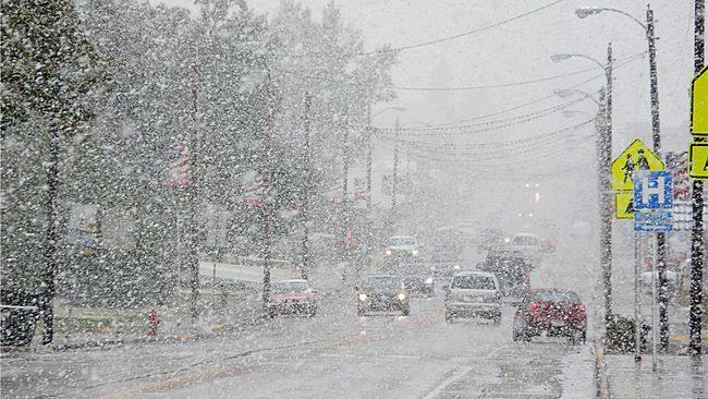
Eerste sneeuwvlokjes melden zich in Cleveland, Ohio. Ik ben benieuwd: Het is mijn eerste winter hier en er schijnt bijna geen stad te zijn met zo'n sterk Lake Effect als Cleveland, en in het bijzonder de buurt waar ik woon.
Het levert wel mooie plaatjes op, deze foto heb ik vanochtend gemaakt nabij Denver:
Nu dus nog een volgende storm op komst, ditmaal wel met warmere lucht.

Nu dus nog een volgende storm op komst, ditmaal wel met warmere lucht.
mooi uitzichtquote:
Het levert wel mooie plaatjes op, deze foto heb ik vanochtend gemaakt nabij Denver:
[ afbeelding ]
Nu dus nog een volgende storm op komst, ditmaal wel met warmere lucht.
Heerlijke stad, mooi plaatje. Vind het nog steeds jammer dat we er toen nooit naar toe zijn verhuisdquote:
Het levert wel mooie plaatjes op, deze foto heb ik vanochtend gemaakt nabij Denver:
[ afbeelding ]
Nu dus nog een volgende storm op komst, ditmaal wel met warmere lucht.
"For the man sound of body and serene of mind, there is no such thing as bad weather; Every day has its beauty. And storms which whip the blood, do make it pulse more vigorously."


Frisjesquote:
Hier ook eindelijk sneeuw en kou!
Vanuit mijn huis lekker naar buiten kijken, het is -25...
[ afbeelding ]
Even apart topic gemaakt van het "lake effect"
WKN / Chaos door zeer zware sneeuwval in delen van de VS
WKN / Chaos door zeer zware sneeuwval in delen van de VS
Ja, de verdamping van grote hoeveelheden water tijdens de sneeuwstorm van de afgelopen dagen onttrekt behoorlijk wat energie aan het water zodat het in combinatie met de lage temperaturen kan bevriezenquote:
De Hudsonbaai begint ook dicht te vriezen.
Niks bijzonders uiteraard, de Hudsonbaai vriest elke winter dicht. Ik kan me vergissen, maar volgens mij ligt er langer wel dan geen ijs.quote:
[..]
Ja, de verdamping van grote hoeveelheden water tijdens de sneeuwstorm van de afgelopen dagen onttrekt behoorlijk wat energie aan het water zodat het in combinatie met de lage temperaturen kan bevriezen
De hoeveelheid ijs ligt nu redelijk op schema.
Nog meer leuke plaatjes en filmpjes:
http://www.adventure-jour(...)snow-bombs-new-york/
En ik ben wel jaloers
http://www.adventure-jour(...)snow-bombs-new-york/
En ik ben wel jaloers
ph'nglui mglw'nafh Cthulhu R'lyeh wgah'nagl fhtagn
Woah, dat is een goede bult. Hier in Denver is het alweer 10 graden overdag, ik denk dat vandaag de laatste resten sneeuw wel zullen dooien.

Het wordt warmer in het gebied waar de sneeuw is gevallen er dreigen nu overstromingen.
Buffalo prepares for snowmelt flooding:
Buffalo prepares for snowmelt flooding:


Volgens het lokale weerbericht gaat hier 60cm sneeuw vallen de komende 3 dagen, gelukkig heb ik afgelopen weekend een extra grote sneeuwschuiver gekocht!
De oprit van mijn huis is redelijk groot (6 auto's kunnen er parkeren) dus misschien moet ik mijn buurman maar eens lief aankijken, die heeft een grote snowblower.
De oprit van mijn huis is redelijk groot (6 auto's kunnen er parkeren) dus misschien moet ik mijn buurman maar eens lief aankijken, die heeft een grote snowblower.
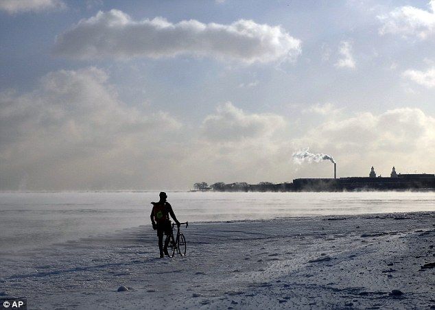
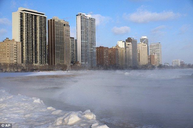
Gevoelstemperatuur in Québec zakt tot -45°C
De winter slaat maandag in alle hevigheid toe in het noorden van de VS en Canada. De meteorologische diensten verwachten ook de komende dagen extreme koude. In Québec kan de gevoelstemperatuur zakken tot -45°C.
Na een sneeuwstorm, gevolgd door regen en ijzel in het weekend, blijft de situatie maandagmiddag moeilijk in de luchthavens van Toronto en Montréal. Honderden vluchten hebben vertraging, tientallen zijn geannuleerd. Chicago, Minneapolis en Buffalo zijn minder hard getroffen.
Het milieuagentschap van Canada heeft waarschuwingen uitgevaardigd voor verschillende Canadese provincies. Inwoners worden gevraagd de nodige maatregelen te treffen vanwege de extreme vriestemperaturen.
De koude treft het oosten van Québec, New Brunswick of Newfoundland en Labrador, het centrum van Ontario en Manitoba, of Alberta in het westen. Maandag 19 uur (Belgische tijd) stond de thermometer op -18°C in Ottawa (Ontario), -23°C in Winnipeg (Manitoba) en -17°C in Chicago (Illinois).
Dinsdag en de komende dagen wordt de situatie nog erger, met sneeuw en koude in bovenstaande regio’s, aldus de meteorologische diensten. ‘Arctische lucht komt de komende dagen de richting van Québec uit’ en de gevoelstemperatuur zal zakken tot -38°C en zelfs -45°C, zegt het Canadese milieuagentschap.
http://www.nieuwsblad.be/(...)campaign=twitterfeed
Kunnen die Amerikanen er eens mee kappen onze sneeuw elk jaar te jatten? Alvast bedankt.
Health In Harmony is een non-profitorganisatie die regenwoudgemeenschappen helpt met gezondheidszorg en duurzame inkomens in ruil voor bosbescherming, en zo tegelijk klimaatverandering en armoede aanpakt. - https://www.healthinharmony.org/
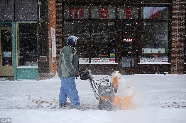
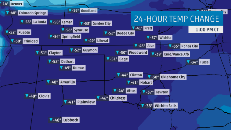
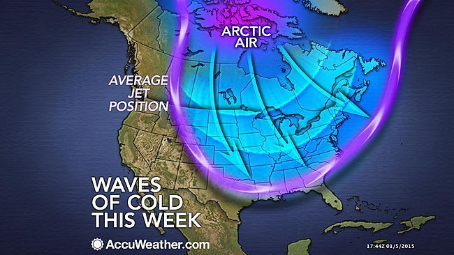
In a weather pattern common for January, waves of arctic air will flow from the Midwest to the Northeast and South into the coming weekend.
The waves of arctic air coming in this week will be painful for those who have to spend time outdoors, unless properly dressed. In addition to the below-average temperatures forecast, AccuWeather.com RealFeel® Temperatures will be 15-30 degrees lower than the actual temperature at times.
The waves of arctic air coming in this week will be painful for those who have to spend time outdoors, unless properly dressed. In addition to the below-average temperatures forecast, AccuWeather.com RealFeel® Temperatures will be 15-30 degrees lower than the actual temperature at times.
Het kan echt wel verschrikkelijk koud worden in New Mexico. Zelf heb ik daar gesnowboard in Taos en Santa Fe.quote:In New Mexico tenslotte zijn de winters koel maar niet extreem koud.
reset
Komt zelfs sneeuw voor in Mexico.quote:
[..]
Het kan echt wel verschrikkelijk koud worden in New Mexico. Zelf heb ik daar gesnowboard in Taos en Santa Fe.
Nieuw luchtdruk record voor de VS.
A sprawling dome of high pressure is on track to spill from Canada across most of the eastern United States over the next several days, bringing sharp winds and some of the coldest air of the season to many locations. While the cold will certainly make its presence known, the truly remarkable aspect of this blast will be the strength of the high pressure itself. In some locations, barometric high pressure readings may reach levels never before observed in January, and one or more all-time records can't be ruled out.
Most high-pressure records east of the Rockies occur during the winter months, as darkness and snow cover allow frigid, dense cold air masses to develop and surge southward. Many all-time pressure records across the plains were established during the memorable cold wave of late December 1983, which sent temperatures down to 9°F as far south as San Antonio and kept Omaha lodged below 0°F for more than a solid week. On December 24 of that year, sea level pressure [SLP] soared to 1064 mb [31.42"] at Miles City, Montana. That value remains the highest sea-level-adjusted pressure on record for the contiguous United States.
[img]http://img.photobucket.com/albums/v628/halloa/Mobile%20Uploads/mslp-1983_zpsrz2ipnaa.png[/img]
A few monthly SLP records appear to be within reach this week, especially as the core of high pressure moves across the Northern and Central Plains on Wednesday. Models are projecting SLP to peak above 1050 mb [about 31.01"] across a relatively large area. Weather Underground historian Chris Burt has a comprehensive site listing all-time high-pressure records for many U.S. cities, and NOAA's David Roth has produced maps (in millibars, or mb) depicting the highest January and highest all-time values at many U.S. locations, typically going back to the 1890s (see this map showing the period of record at each site). Among the spots to watch
[ Bericht 12% gewijzigd door #ANONIEM op 06-01-2015 15:17:54 ]
Vanochtend;quote:Op dinsdag 6 januari 2015 07:55 schreef SpecialK het volgende:
Kunnen die Amerikanen er eens mee kappen onze sneeuw elk jaar te jatten? Alvast bedankt.

Van mij mag je het hebben. Troep dat het is. Overal weer stapvoets vandaag. En dan daalt 't woensdagnacht ook nog eens tot -20 Celsius. En we krijgen nog meer sneeuw als 't goed is.
Ik vind sneeuw best tof. Maar eigenlijk alleen als ik binnen zit en nergens heen hoef.
"Bleach is healthy. It's mostly water. And we are mostly water. Therefore, we are bleach."
Watje haha! Hier was het rond de -36 (gevoelstemp) vanochtend en vanacht wordt het -32 met een gevoelstemp van -41.quote:Op dinsdag 6 januari 2015 17:00 schreef OMG het volgende:
En dan daalt 't woensdagnacht ook nog eens tot -20 Celsius
Sfeerbeelden van de kou hier:

quote:
"Bleach is healthy. It's mostly water. And we are mostly water. Therefore, we are bleach."

Lol ok je woont dus vrij zuidelijk neem ik aan! Wij hebben hier geen electrische heatpumps.quote:
[..]. 't is meer dat de verwarming dan de hele nacht op emergency heat staat te loeien omdat de heat pump buiten niks uithaalt, en dat ik niet uitkijk naar een elektriciteitsrekening die meer dan het dubbele is dan dat 't de kou is.
Ik woon in Indianapolis. Vrij zuidelijk vanuit Canada gezien.quote:
[..]
Lol ok je woont dus vrij zuidelijk neem ik aan! Wij hebben hier geen electrische heatpumps.

"Bleach is healthy. It's mostly water. And we are mostly water. Therefore, we are bleach."
quote:VS maken zich op voor extreme koude
Na ongewoon milde winterweken moeten miljoenen Amerikanen zich schrap zetten voor extreme koude.
Zowat vijftig miljoen Amerikanen in 24 van de 50 staten staan de koudste temperaturen sinds lange tijd te wachten, zei meteorologe Karen Maginnis tegen nieuwszender CNN. In delen van Wisconsin, Minnesota en North Dakota kunnen door de ijzige wind gevoelstemperaturen tot minstens 45 graden opduiken. Maginnis waarschuwde ervoor dat dergelijke kou dodelijk en gevaarlijk kan zijn.
Op een berg in New Hampshire is reeds een gevoelstemperatuur van min 56 graden waargenomen, meldde de nationale weerdienst op Twitter. Aan de oostelijke kusten was er reeds sneeuwval die zal afnemen of in regenbuien zal veranderen.
Da's toch niet ongebruikelijk voor deze staten in deze tijd van het jaar...maar wel koud natuurlijkquote:
Gelukkig gaat het volgende week naar een temperatuur die warmer dan het jaar gemiddelde is! Voorspelling is -4 in mijn gebied, da's 40 graden warmer dan een paar dagen geleden.
Weer bijna hetzelfde als vorig jaar. Het is daar lang koud en hier lang winderig en nat met temperaturen die niet bij winter horen
Never Stop Exploring!
Life begins at the end of your comfort zone!
Follow me on Twitter: https://twitter.com/EdwinKr83 Instagram: https://www.instagram.com/edwinkr83/
Life begins at the end of your comfort zone!
Follow me on Twitter: https://twitter.com/EdwinKr83 Instagram: https://www.instagram.com/edwinkr83/
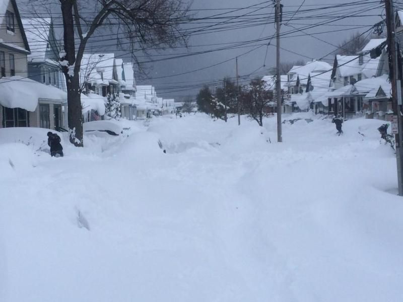
Recordkou legt deel Verenigde Staten plat
IJskoude wind teistert het oosten en midwesten van de Verenigde Staten. Scholen bleven vandaag gesloten, treinen liepen vertraging op en vluchten moesten worden afgelast. In het noorden van de staat New York valt donderdag een sneeuwpak van minstens een meter. In de rest van het land is het droog maar ijskoud, meldde het nationale weerinstituut.
Het koudste plekje in de VS was Estcourt Station, het noordelijkste puntje van de staat Maine, waar het kwik daalde tot min 39 graden Celsius. In het hele land sneuvelden weerrecords.
Het weerinstituut raadt de Amerikanen aan binnen te blijven, omdat binnen een kwartier lichaamsdelen kunnen bevriezen.
http://www.trouw.nl/tr/nl(...)de-Staten-plat.dhtml
Hier in Colorado is ditmaal weinig te merken van de kou, overdag dooi, 's nachts lichte vorst. 10 dagen terug nog wel de -30 aangetikt trouwens. Het resultaat is nu wel dat het fantastisch weer is op de pistes
Aantal aparte topic gemaakt. Om ze terug te vinden zet ik de links hier even neer.
WKN / 'Historische' sneeuwstorm voor noordoosten van de VS
WKN / Video: IcyRoads New Jersey: Geluk bij een ongeluk?
WKN / Nieuwe sneeuwstorm in de VS
En de meest recente: WKN / Sneeuwstormen en extreme gevoelstemperatuur voor de VS
WKN / 'Historische' sneeuwstorm voor noordoosten van de VS
WKN / Video: IcyRoads New Jersey: Geluk bij een ongeluk?
WKN / Nieuwe sneeuwstorm in de VS
En de meest recente: WKN / Sneeuwstormen en extreme gevoelstemperatuur voor de VS
Hier ook zoiets; vorige week maandag nog een -42 windchill en komend weekend wordt er 18 graden voorspeld, lekker 60 graden verschil in twee weekjes! Alles begint nu wel lekker te smelten, al staan veel straten blank dus is het eventjes moelijk lopen.quote:
Hier in Colorado is ditmaal weinig te merken van de kou, overdag dooi, 's nachts lichte vorst. 10 dagen terug nog wel de -30 aangetikt trouwens. Het resultaat is nu wel dat het fantastisch weer is op de pistes
quote:Weer sneeuwrecord voor Boston
In de Amerikaanse stad Boston is sinds de start van de metingen nog nooit zoveel sneeuw gevallen als de afgelopen maanden. Volgens het Amerikaanse nationale weerinstituut is het oude record zondagavond verbroken. Er viel 7,5 centimeter sneeuw, waardoor er over de hele winter 275,8 centimeter is gevallen, ruim twee centimeter meer dan in de winter van 1995-1996.
In de Amerikaanse stad Boston is sinds de start van de metingen nog nooit zoveel sneeuw gevallen als de afgelopen maanden, ook afgelopen zondag was het weer raak en viel er de nodige sneeuw.
„Boston, jullie hebben de winter met de meeste sneeuw overleefd”, schreef het weerinstituut op Facebook. Dat het de meest sneeuwachtige winter ooit zou worden, zat er al even aan te komen. Eerder sneuvelden al de records voor meeste sneeuw in twee weken en meeste sneeuw in een maand.
In Boston en omgeving viel vooral in januari en februari veel sneeuw. In februari werd daardoor de noodtoestand uitgeroepen. Meer dan 100 gebouwen in de stad in het noordoosten van de Verenigde Staten zijn de afgelopen maanden ingestort, omdat de daken de hevige sneeuwval niet aan konden.

Loop ik zonder mijn jas gezellig in het zonnetje naar de bus, krijg ik een weerswaarschuwing voor sneeuw morgen idd  Hoopte dat het onderhand wel eens lente zou worden...
Op dinsdag 1 november 2016 00:05 schreef JanCees het volgende:
De polls worden ook in 9 van de 10 gevallen gepeild met een meerderheid democraten. Soms zelf +10% _O-
De polls worden ook in 9 van de 10 gevallen gepeild met een meerderheid democraten. Soms zelf +10% _O-
Echt, he. Van de week lekker met een t-shirt aan en de ramen open naar huis gereden, want 't was bijna 70F. De laatste paar dagen heb ik m'n winterjas weer aan moeten doen, want 't is high 30s / low 40s 's ochtends.
"Bleach is healthy. It's mostly water. And we are mostly water. Therefore, we are bleach."
Ik ben er wel klaar mee, het was erg mooi met alle sneeuw maar ben nu wel aan t-shirts en zon toe!quote:
Echt, he. Van de week lekker met een t-shirt aan en de ramen open naar huis gereden, want 't was bijna 70F. De laatste paar dagen heb ik m'n winterjas weer aan moeten doen, want 't is high 30s / low 40s 's ochtends.
sneeuwfoto van 2-3 weken geleden omdat het kan:

Op dinsdag 1 november 2016 00:05 schreef JanCees het volgende:
De polls worden ook in 9 van de 10 gevallen gepeild met een meerderheid democraten. Soms zelf +10% _O-
De polls worden ook in 9 van de 10 gevallen gepeild met een meerderheid democraten. Soms zelf +10% _O-
In het Nederlands gebruiken we graden Celsius.quote:
Echt, he. Van de week lekker met een t-shirt aan en de ramen open naar huis gereden, want 't was bijna 70F. De laatste paar dagen heb ik m'n winterjas weer aan moeten doen, want 't is high 30s / low 40s 's ochtends.
"For the man sound of body and serene of mind, there is no such thing as bad weather; Every day has its beauty. And storms which whip the blood, do make it pulse more vigorously."
|
|