WKN Weer, Klimaat en Natuurrampen
Lees alles over het onstuimige weer op onze planeet, volg orkanen en tornado's, zie hoe vulkanen uitbarsten en hoe Moeder Aarde beeft bij een aardbeving. Alles over de verwoestende kracht van onze planeet en tal van andere natuurverschijnselen.


Sneeuwstorm voor de VS
Amerikaanse weerkundigen verwachten komende week een sneeuwstorm voor het noordoosten van de VS. Steden als New York en Boston kunnen rekenen op harde wind met veel sneeuw. Er wordt 60 cm voorspeld, wat met de harde wind kan zorgen voor sneeuwduinen waardoor het verkeer tot stilstand zal komen.
Dinsdag neemt het systeem boven de Atlantische oceaan snel in kracht toe tot een zware storm.
Amerikaanse weerkundigen verwachten komende week een sneeuwstorm voor het noordoosten van de VS. Steden als New York en Boston kunnen rekenen op harde wind met veel sneeuw. Er wordt 60 cm voorspeld, wat met de harde wind kan zorgen voor sneeuwduinen waardoor het verkeer tot stilstand zal komen.

Dinsdag neemt het systeem boven de Atlantische oceaan snel in kracht toe tot een zware storm.
quote:A major winter storm will unfold across the Northeast early this week, eventually becoming an all-out blizzard over parts of New England and the New York City area.
Those in the Northeast should prepare for the storm now rather than wait until the snow starts to fall, especially for those across eastern New England.
"While the storm from Saturday may have been a mere nuisance to travelers and a delight to skiers, the storm Monday night into Tuesday could be far more disruptive in terms of travel and daily activities," said AccuWeather.com Senior Meteorologist Alex Sosnowski.
The greatest impacts are expected along the Interstate-95 corridor from Philadelphia northward where over a foot of snow is forecast to fall. The blizzard also threatens to bring the heavily populated zone from New York City to Boston to Portland, Maine, to a standstill.
@accuweather
Nooit, hoop ik.quote:Op zondag 25 januari 2015 16:44 schreef Admiraal_Kontkanaal het volgende:
Wanneer gebeurd dat nou eens een keer hier?
Acquisitie n.a.v. deze post wordt niet op prijs gesteld.
Don't you see going to heaven is just in the thought that you might?
As an on-line radio program grows longer, the probability of a German song approaches 1.
Don't you see going to heaven is just in the thought that you might?
As an on-line radio program grows longer, the probability of a German song approaches 1.
Niet iedereen gaat naar de basisschool.quote:
Acquisitie n.a.v. deze post wordt niet op prijs gesteld.
Don't you see going to heaven is just in the thought that you might?
As an on-line radio program grows longer, the probability of a German song approaches 1.
Don't you see going to heaven is just in the thought that you might?
As an on-line radio program grows longer, the probability of a German song approaches 1.
quote:
[..]
Niet iedereen gaat naar de basisschool.
Ik hoop komende weekquote:
Wanneer gebeurd dat nou eens een keer hier?
Het werk blijft wel liggen, dus als je wel weer gaat werken, heb je ineens een hele berg werk waar je je doorheen moet worstelen. Leuk man! Maar goed, ieder zijn ding.quote:Op zondag 25 januari 2015 17:00 schreef Admiraal_Kontkanaal het volgende:
als er 60cm ligt en het verkeer ligt stil hoef je ook niet te werken. Tenminste, ik niet.
Acquisitie n.a.v. deze post wordt niet op prijs gesteld.
Don't you see going to heaven is just in the thought that you might?
As an on-line radio program grows longer, the probability of a German song approaches 1.
Don't you see going to heaven is just in the thought that you might?
As an on-line radio program grows longer, the probability of a German song approaches 1.

Lijkt erop dat er een historische hoeveelheid sneeuw gaat vallen de komende dagen. Vooral rond Boston kan het oplopen tot 90 cm. En daarbij nog een storm.

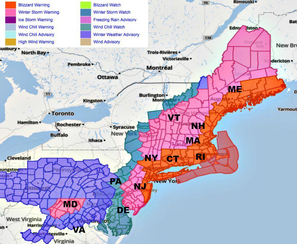
Blizzard Warning
URGENT - WINTER WEATHER MESSAGE
NATIONAL WEATHER SERVICE MOUNT HOLLY NJ
408 PM EST SUN JAN 25 2015
...A MAJOR WINTER STORM WILL IMPACT OUR AREA MONDAY INTO TUESDAY...
.LOW PRESSURE WILL TRACK FROM THE OHIO VALLEY TO THE MID ATLANTIC
TONIGHT AND MONDAY MORNING BRINGING MAINLY SOME LIGHT SNOW TO MUCH
OF THE REGION. THIS STORM WILL THEN RAPIDLY INTENSIFY INTO A
NOR`EASTER LATE MONDAY. THERE IS STILL SOME UNCERTAINTY WITH THE
DETAILS, MAINLY FOR THE WESTERN AND SOUTHWESTERN AREAS OF OUR
REGION. THIS STORM IS EXPECTED TO RESULT IN DETERIORATING
CONDITIONS AS WE GO THROUGH MONDAY INTO TUESDAY, WITH WIDESPREAD
TRAVEL IMPACTS EXPECTED.
Daarstraks heb ik van iemand in Massachusetts gehoord dat er '30 inches of snow' verwacht worden. 75 centimeter sneeuw dus 
Ik zou drinken en voedsel inslaan.
Ik zou drinken en voedsel inslaan.
Acquisitie n.a.v. deze post wordt niet op prijs gesteld.
Don't you see going to heaven is just in the thought that you might?
As an on-line radio program grows longer, the probability of a German song approaches 1.
Don't you see going to heaven is just in the thought that you might?
As an on-line radio program grows longer, the probability of a German song approaches 1.
91 cm heb ik al gezien (38 inches). Plaatselijk wordt het vaak nog hoger dan de verwachting.quote:
Daarstraks heb ik van iemand in Massachusetts gehoord dat er '30 inches of snow' verwacht worden. 75 centimeter sneeuw dus
Ik zou drinken en voedsel inslaan.

Dat dus.quote:
Wanneer gebeurd dat nou eens een keer hier?

Bronquote:It appears that all of the classic ingredients are lining up to produce a historic nor’easter snowstorm. Temperatures on Sunday morning across southern New England were near or slightly above freezing, but a weak cold front is pushing through the area, steered by a separate branch of the jet stream over eastern Canada. This cold, dry low-level air, plus the storm’s track being far enough offshore, will ensure that nearly all precipitation falls as snow for the duration of this storm across the entire region. The main exception is the outer reaches of Cape Cod and Nantucket, where a periodic changeover to rain is possible.
How much snow?
The heaviest snow totals are likely to occur along a SW-to-NE belt oriented from somewhere near or just east of New York City to eastern Massachusetts in or near Boston. In situations like these, narrow strips of intense snow (mesoscale bands) are typically oriented along an upper-level “bent-back” warm front that arcs west from the consolidating storm. Wherever these bands set up, snowfall rates can easily exceed 3”/hour. It’s impossible to predict the exact location of the bands this far in advance. However, mesoscale forecast tools such as NOAA’s new High-Resolution Rapid Refresh model (which became operational just last fall) should provide more detailed guidance by late Monday.
Given the projected intensity of this storm, as well as the strong model agreement and the textbook nature of the overall pattern, it seems very plausible to expect widespread snowfalls from Monday night through Tuesday night of 12” to 24” between northern New Jersey and southwest Maine, with some areas in mesoscale bands getting 24” to 36”. Lesser amounts can be expected further to the southwest, with Philadelphia possibly getting a few inches on top of its Monday total. If the system moves more slowly than expected, it could add to the accumulations on the southern and western flank of the vast snow shield. Massive transportation impacts can be expected over the next several days, with reverberations to the air-traffic system nationwide. The high winds and snow could lead to large-scale power outages across New England.


quote:North-east US on alert for blizzard as cities face 'potentially historic' storm
A winter that has largely spared the north-eastern US is about to arrive with gusto: a storm the National Weather Service (NWS) called “potentially historic” could dump 2ft to 3ft of snow from northern New Jersey to Connecticut.
A blizzard warning was issued for New York and Boston, and the NWS said the massive storm would bring heavy snow and powerful winds starting on Monday and going into Tuesday.
“This could be a storm the likes of which we have never seen before,” New York City mayor Bill de Blasio said at a news conference on Sunday.
De Blasio held up a piece of paper showing the city’s top 10 snowstorms and said this one could land at the top of a list that goes back to 1872, including the 26.9in that fell in 2006. “Don’t underestimate this storm. Prepare for the worst,” he said as he urged residents to plan to leave work early on Monday.
Boston is expected to get 18in to 24in of snow, and Philadelphia could see 14in to 18in, the NWS said.
A weekend storm that had brought snow and slush to the north-east – the first real snow of the season for many areas – was just a warm-up.
“Looks like our luck is about to run out,” said John Paulsen as he gassed up his SUV in New Jersey. “I can’t complain too much since we’ve had a pretty mild winter, but I don’t know if I’m ready for a foot or so of snow all at once.”
The storm system driving out of the Midwest brought snow to Ohio on Sunday and was expected to ultimately spread from the nation’s capital to Maine for a “crippling and potentially historic blizzard”, the NWS said.
The Washington area expected only a coating or a bit more, with steadily increasing amounts expected as the storm moved north. The storm promised treacherous travel by both land and air throughout the busy north-east corridor.
At New York’s Penn Station, Cicero Goncalves was waiting for a train to Vermont, where he was going snowboarding, because he expected the flight he had hoped to take would be canceled. But the 34-year-old flight attendant from Queens counted himself and his travel partner as lucky.
“We’ll get there before it snows, and we’re coming back when the storm is over, on Thursday,” he said.
Preparations large and small were in effect elsewhere in New York. A Manhattan Home Depot store sold about twice as many shovels over the weekend as it normally does while transit officials hoping to keep the subways running smoothly planned to use modified subway cars loaded with de-icing fluid to spray the third rail that powers trains.
Farther north, a blizzard warning was issued for Boston from Monday night through early Wednesday. Wind gusts of 60mph or more are possible on Cape Cod, forecasters said.
Wyatt Baars, manager of the Charlestown Ace Hardware in Boston, sold out of his bags of ice-melting pellets. But he said a New Hampshire distributor was helping him and delivering more.
“Everybody is preparing for the storm,” he said. “When we have something this big on the horizon, everybody comes in for the ice melt, snow shovels, snow brooms.”
Snow plow driver Al Laplant expected to be out clearing roads of Simsbury, Connecticut, this week, just as he has for more than two decades.
“We’ll be out there until the storm’s over and then at least three hours after cleaning up,” he said as he attended a home show in Hartford. “We’ll be out there through the whole storm.”
But even for a plow driver, the snow is no cakewalk.
“It’s kind of exhilarating,” he said. “But at the same time, I’ve been doing it for 27 years, so I’m kind of tired of it myself.”
quote:New York en omgeving zetten zich schrap voor zwaarste sneeuwstorm in de geschiedenis
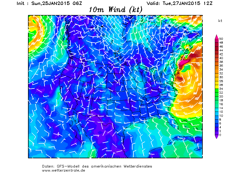
De National Weather Service heeft code rood afgegeven voor de hele oostkust van de VS. Van Pennsylvania tot aan New Brunswick valt de komende 72 uur extreem veel sneeuw. In het gebied tussen New York en Boston word 24 tot 36 inch sneeuw verwacht, omgerekend 60 tot 90 cm sneeuw. Het gaat niet alleen sneeuwen, maar ook nog eens heel hard waaien. Langs de kust bij Boston wordt dinsdagochtend een zware storm (windkracht 10) verwacht en hoge golven. Het schiereiland Cape Cod krijgt de meeste wind, daar kunnen winduitschieters voorkomen met orkaankracht. De bevolking van New York City en New England bereidt zich voor op een van de zwaarste sneeuwstormen uit de geschiedenis.
Monsterdepressie
De sneeuwstorm wordt veroorzaakt door een lagedrukgebied dat de afgelopen dagen nog boven het vasteland van de VS verbleef. Vanmiddag komt dat lagedrukgebied boven de Atlantische Oceaan voor de kust van North Carolina en Virginia met een kerndruk van 1004 hPa te liggen. Vlak aan zee zijn de zeewatertemperaturen 5 a 6 graden. Verder uit de kust, waar de warme golfstroom warmer zeewater aanvoert vanuit het zuiden is het zeewater een graad of 20. Boven het warme zeewater diept het lagedrukgebied de komende 36 uur uit tot een monsterdepressie (979 hPa, dinsdagavond) en veroorzaakt noord tot noordoostwaarts trekkend veel neerslag, veel wind en golfslag. In het kielzog van de depressie wordt koude lucht vanuit het oosten van Canada aangevoerd en gaat de neerslag op steeds meer plaatsen over in sneeuw. Gisteren viel er al sneeuw in Chicago, Pittsburgh, Harrisburg en Philadelphia, Pennsylvania. De sneeuw bereikt New York als daar de zon opkomt (vanmiddag onze tijd). Rondom het lagedrukgebied steekt een storm tot zware storm op en worden er ook boven land zware tot zeer zware windstoten verwacht. Door de wind kunnen sneeuwduinen ontstaan van meer dan 2 of 3 meter.
Gevolgen
Blizzard-achtige condities zullen het verkeer op highway 95 van Baltimore naar New York en Portland vanaf maandagavond vrijwel volledig stilleggen. Inmiddels zijn veel vliegvelden al gesloten. Verwacht wordt dat de zeer zware windstoten en de vele sneeuw op grote schaal schade zullen veroorzaken aan gebouwen in het zeer dichtbevolkte deel van de VS. Door het grote gewicht van de vele sneeuw kunnen daken instorten en omdat veel elektriciteitsleidingen in de VS nog steeds bovengrond lopen, wordt rekening gehouden dat de stroom zal uitvallen. Langs de kust van Massachusetts worden door de hoge golven overstromingen verwacht. Verwacht wordt dat de problemen die de komende dagen zullen ontstaan, pas in de tweede helft van de week voorbij zullen zijn.

Erik Mouthaan bevriezend t-shirt test deel 2.
* Ajax * Arsenal * Barca * Fiorentina * Napoli * Leeds *
quote:
Wanneer gebeurd dat nou eens een keer hier?

Moet je echt niet willen als je ziet hoe ontwrichtend dit daar al is.quote:
* Ajax * Arsenal * Barca * Fiorentina * Napoli * Leeds *
Drinken genoeg, kwestie van laten ontdooienquote:
Daarstraks heb ik van iemand in Massachusetts gehoord dat er '30 inches of snow' verwacht worden. 75 centimeter sneeuw dus
Ik zou drinken en voedsel inslaan.
Komende Vrijdagquote:
Wanneer gebeurd dat nou eens een keer hier?
In Baden-Badener Badeseen kann man Baden-Badener baden sehen.
|
|