WKN Weer, Klimaat en Natuurrampen
Lees alles over het onstuimige weer op onze planeet, volg orkanen en tornado's, zie hoe vulkanen uitbarsten en hoe Moeder Aarde beeft bij een aardbeving. Alles over de verwoestende kracht van onze planeet en tal van andere natuurverschijnselen.


Je had het over 40 graden in Limburg.quote:
You don't need a weatherman to know which way the wind blows.
---------------------------------------------------------------------------------------------------------------------------------------------
Album top 100 2024
---------------------------------------------------------------------------------------------------------------------------------------------
Album top 100 2024
Kijk nog eens beter op het kaartjequote:Op zaterdag 18 augustus 2012 22:01 schreef Felagund het volgende:
[..]
Je had het over 40 graden in Limburg.
Hier gaat het weer langzaam naar 29 graden.quote:
hier ook 28 graden buiten
nadeel is wel veel hangjongeren buiten
You don't need a weatherman to know which way the wind blows.
---------------------------------------------------------------------------------------------------------------------------------------------
Album top 100 2024
---------------------------------------------------------------------------------------------------------------------------------------------
Album top 100 2024
Alleen die lichte kleur is 40 graden toch?quote:
[..]
Kijk nog eens beter op het kaartje
You don't need a weatherman to know which way the wind blows.
---------------------------------------------------------------------------------------------------------------------------------------------
Album top 100 2024
---------------------------------------------------------------------------------------------------------------------------------------------
Album top 100 2024
Ja en die bedekt toch half limburg...quote:
[..]
Alleen die lichte kleur is 40 graden toch?
Ik zit dus in dit roze gebied:
En zag zojuist een flits.

En zag zojuist een flits.
Een ballonvaarder die door de mand valt is nooit grappig...
Buiten voelt het nu aangenaam aan vergeleken met binnen. 
Toen ik een paar jaar geleden in Texas woonde kon ik zoveel beter tegen hitte. Daar stond de airco altijd op zo'n 28 graden en dat voelde koel aan.
Toen ik een paar jaar geleden in Texas woonde kon ik zoveel beter tegen hitte. Daar stond de airco altijd op zo'n 28 graden en dat voelde koel aan.
Ik verwacht een mooie fotoquote:
Ik zit dus in dit roze gebied:
[ afbeelding ]
En zag zojuist een flits.
"Some guys they just give up living and start dying little by little piece by piece"
last.fm | Rate Your Music | MusicMeter | top 100 nummers | top 100 albums | top 50 2013 | top 100 jazz | Onze-blog: pat-sounds
last.fm | Rate Your Music | MusicMeter | top 100 nummers | top 100 albums | top 50 2013 | top 100 jazz | Onze-blog: pat-sounds
Vuurwerk?
I am unconditionally and irrevocably in love with him.
I'm 97% sure you don't like me, I'm 100% sure I don't care.
I'm 97% sure you don't like me, I'm 100% sure I don't care.

er zijn geen wolken...
er zijn wel flink wat ufo-meldingen geweest in ZH de laatste dagen.
miss. is t dat
er zijn wel flink wat ufo-meldingen geweest in ZH de laatste dagen.
miss. is t dat
| Wordfeud: marcel-o |plug.dj/uptempo |<-- draai zelf je platen

WTF?quote:Op zaterdag 18 augustus 2012 21:43 schreef NaturalScience het volgende:
Voor Limburg wordt morgen grootschalig de 40 graden verwacht.
Zelfs een 41 graden kan mogelijk zijn in Limburg morgen.....
Never in the entire history of calming down did anyone ever calm down after being told to calm down.
Ik ben nooit in Texas geweest, maar ik verwacht een wat lagere luchtvochtigheid daar.quote:
Buiten voelt het nu aangenaam aan vergeleken met binnen.
Toen ik een paar jaar geleden in Texas woonde kon ik zoveel beter tegen hitte. Daar stond de airco altijd op zo'n 28 graden en dat voelde koel aan.
Ik ben net terug na 3 weken 30+ in de Languedoc, en ik vind het hier vies warm, terwijl ik daar geen probleem had met de temperatuur.
[b]Op maandag 6 september 2010 00:28 schreef tong80 het volgende:[/b]
GVD Wat moet jij een trotse vader zijn :)
:P
GVD Wat moet jij een trotse vader zijn :)
:P

Details:
Temperaturen tot 33°C, lokaal nog wat meer. Opbouwende CAPE richting 2000-3000J/KG bij een LI van -10/-11. KO-index tot -18. Eerst vrij grote CIN-waarden, maar die zijn stijgend naarmate de avond. Wolkentoppen tot 12km hoog, lokaal kan dat nog wat hoger. Hoge wolkenbasissen tot 1700m, maar wel met een groot verschil tussen LCL en LFC. Er is een aanzienlijke shear aanwezig in de late avond en nacht, met 30-40kts DLS en 25kts LLS. SRH-waarden gaan tot 175m²/s² en met een uitschietende supercell parameter. Tijdens het onweer zijn er hagelstenen mogelijk tot 3cm of heel lokaal nog wat groter.
Samenvatting:
Morgen zal het een erg warme dag worden, met maxima die vlot richting 33°C klimmen en dat kan lokaal nog wat hoger. De onstabiliteit neemt snel toe en in de avond stijgen de onweerskansen vanuit het zuid-westen. Er is een zekere CAP aanwezig die het ontstaan van onweer kan tegenhouden, het is nog niet zeker of die CAP doorbroken zal worden of niet, maar de laatste GFS en WRF prognoses laten toch uitblijken dat dit in de loop van de (late) avond mogelijk wordt. Door de aanwezige richtingsschering in de onderste lagen en snelheidsschering in de bovenste lagen is het niet uit te sluiten dat we een lokale roterende cel kunnen zien. Lokaal kan het onweer dus fel uithalen. Tijdens de onweders zijn felle rukwinden, veel neerslag op korte tijd en hagel. De onweders zouden zich vooral fixeren op het westen en centrum van België en het zuid-westen van Nederland.
http://www.weerfotos.be/BOV/
Life is Music
ik vind het een terechte waarschuwing. Als de remmende factor doorbroken wordt kan het flink los gaan.quote:
[ afbeelding ]
Details:
Temperaturen tot 33°C, lokaal nog wat meer. Opbouwende CAPE richting 2000-3000J/KG bij een LI van -10/-11. KO-index tot -18. Eerst vrij grote CIN-waarden, maar die zijn stijgend naarmate de avond. Wolkentoppen tot 12km hoog, lokaal kan dat nog wat hoger. Hoge wolkenbasissen tot 1700m, maar wel met een groot verschil tussen LCL en LFC. Er is een aanzienlijke shear aanwezig in de late avond en nacht, met 30-40kts DLS en 25kts LLS. SRH-waarden gaan tot 175m²/s² en met een uitschietende supercell parameter. Tijdens het onweer zijn er hagelstenen mogelijk tot 3cm of heel lokaal nog wat groter.
Samenvatting:
Morgen zal het een erg warme dag worden, met maxima die vlot richting 33°C klimmen en dat kan lokaal nog wat hoger. De onstabiliteit neemt snel toe en in de avond stijgen de onweerskansen vanuit het zuid-westen. Er is een zekere CAP aanwezig die het ontstaan van onweer kan tegenhouden, het is nog niet zeker of die CAP doorbroken zal worden of niet, maar de laatste GFS en WRF prognoses laten toch uitblijken dat dit in de loop van de (late) avond mogelijk wordt. Door de aanwezige richtingsschering in de onderste lagen en snelheidsschering in de bovenste lagen is het niet uit te sluiten dat we een lokale roterende cel kunnen zien. Lokaal kan het onweer dus fel uithalen. Tijdens de onweders zijn felle rukwinden, veel neerslag op korte tijd en hagel. De onweders zouden zich vooral fixeren op het westen en centrum van België en het zuid-westen van Nederland.
http://www.weerfotos.be/BOV/
[b]Op maandag 6 september 2010 00:28 schreef tong80 het volgende:[/b]
GVD Wat moet jij een trotse vader zijn :)
:P
GVD Wat moet jij een trotse vader zijn :)
:P
er is potentie. of het wat wordt is afwachten. kans lijkt mij klein,maar er is een kans.quote:
Zal wel weer op niks uitlopen zoals bij de vorige melding...
[b]Op maandag 6 september 2010 00:28 schreef tong80 het volgende:[/b]
GVD Wat moet jij een trotse vader zijn :)
:P
GVD Wat moet jij een trotse vader zijn :)
:P
zag het op de satelliet ook, maar niet schokkend. We zien morgen wel,als het los gaat zien we het hier als eerstequote:
Vanmiddag zag het hier in Zeeland al wat onstabiel uit.
Trusten
[b]Op maandag 6 september 2010 00:28 schreef tong80 het volgende:[/b]
GVD Wat moet jij een trotse vader zijn :)
:P
GVD Wat moet jij een trotse vader zijn :)
:P

Jeetje wat is het nog bizar warm hier rond deze tijd.
Ik wacht nog ff met slapen tot me ogen echt dichtvallen. Moment begint wel te naderen.
Dan maakt het niet uit of het warm is of niet want je valt dan echt wel weg
Ik wacht nog ff met slapen tot me ogen echt dichtvallen. Moment begint wel te naderen.
Dan maakt het niet uit of het warm is of niet want je valt dan echt wel weg
Zonder wrijving geen glans
Ik heb in Rome twee weken geleden 40 graden meegemaakt, vandaag dus op herhaling. Ik ben benieuwd of het anders aan gaat voelen.
Is God willing to prevent evil, but not able? Then he is not omnipotent.
Is he able, but not willing? Then he is malevolent.
Is he both able and willing? Then whence cometh evil?
Is he neither able nor willing? Then why call him God?
Is he able, but not willing? Then he is malevolent.
Is he both able and willing? Then whence cometh evil?
Is he neither able nor willing? Then why call him God?

Pfff als er nou nog wat wind was...
Waarom kan het hier nooit 20 graden zijn voor een paar weken, waarom altijd van die uiterste...
Waarom kan het hier nooit 20 graden zijn voor een paar weken, waarom altijd van die uiterste...
Net een half uurtje op de snorfiets gezeten, maar ik vind het gewoon klam.
En een overschot aan insecten en spinnen
En een overschot aan insecten en spinnen
Als het niet met een hamer te repareren is, is het een elektrisch probleem.
gewoon rustig gaan liggenquote:
Hoe kan ik in 25,4 graden slapen >.<
[ afbeelding ]
Misschien heb ik gewoon mazzel maar ik slaap prima als het zo warm is. Niet gaan woelen, gewoon rustig liggen en zorgen dat je echt moe bent.
know'm sayin?
×
word? word.
×
word? word.

Ik wil slapen, maar hier binnen op zolder is het nog steeds ruim 30 graden. Alles staat open maar waait niks door. Pffffff.
Faber quisque fortunae suae.
Uit Eindhoven
Uit Eindhoven
Swaffelen helpt een beetje.quote:
Ik wil slapen, maar hier binnen op zolder is het nog steeds ruim 30 graden. Alles staat open maar waait niks door. Pffffff.
Blij dat ik morgen mag werken. In een koelcel.
Het enige nadeel is dan weer als het werk gedaan is. Dan moet ik weer in die gloeiende auto stappen...
Het enige nadeel is dan weer als het werk gedaan is. Dan moet ik weer in die gloeiende auto stappen...
Helikopteren helpt iets beter.quote:
Haha, U schakelt nog. Test een DAF !
Allemachtig. Ik lig op dit moment op bed. Nou ja meer een zwembed. Ik ben zo klam als wat. Ong 30graden in de slaapkamer  . Leuk en aardig die warmte maar slapen is zo kut
Ok wie heeft dit weer besteld?
Beneden gaat het nog wel maar als je de trap opgaat loop je zo klein Dubai in.
Beneden gaat het nog wel maar als je de trap opgaat loop je zo klein Dubai in.
Ik ga op het dakterras liggen, slaapt binnen voor gee meter
"We meet every day at the same cafe, six-thirty and no one knows she'll be there."
fukking heet...dat dit kan in nl wel heerlijk genoten met pils & rose en BBQ aan de ijssel! Wel vaag dat de temperatuur nog 23 graden buiten is...
Never Stop Exploring!
Life begins at the end of your comfort zone!
Follow me on Twitter: https://twitter.com/EdwinKr83 Instagram: https://www.instagram.com/edwinkr83/
Life begins at the end of your comfort zone!
Follow me on Twitter: https://twitter.com/EdwinKr83 Instagram: https://www.instagram.com/edwinkr83/
Het weerbericht op de radio steeds... maxium temp van 38 graden.. U zei??  hehe het klinkt zo maf dat getal.
[b]Hobbelicious is back!
[/b]
[/b]
't is wel een pokkehitte deze keer...
Tsjah... nou wordt het 38°C en over een week is het afgekoeld en is iedereen verkouden met een lichaamstemperatuur van 38°C.quote:
Het weerbericht op de radio steeds... maxium temp van 38 graden.. U zei??
Oh getsie zeg, niet te hopen dat er meteen een virus achteraan komtquote:
't is wel een pokkehitte deze keer...
[..]
Tsjah... nou wordt het 38°C en over een week is het afgekoeld en is iedereen verkouden met een lichaamstemperatuur van 38°C.
[b]Hobbelicious is back!
[/b]
[/b]
Zo dalijk rond 7 uur naar bruhl in Deutschland.
Lekker in de water attracties!! :-D
Lekker in de water attracties!! :-D
Kimi for wdc 2012
Tjezus, ehmmm, veel plezier dan maar in fantasialand
Ik zit nu buiten en het is echt absurd, je verwacht koelte aan het einde van de nacht, nou niet dus
Ik zit nu buiten en het is echt absurd, je verwacht koelte aan het einde van de nacht, nou niet dus
Klonk is alleen Klonk als er Klonk op staat
Ik wil trouwens een tshirt met als opdruk "ik heb 19 augustus overleefd"
Zo voelt het echt voor mij, als ik straks ga slapen is het voorbij, morgen nog maar 28 graden en dan zakt het naar heerlijk zomers weer.
Zo voelt het echt voor mij, als ik straks ga slapen is het voorbij, morgen nog maar 28 graden en dan zakt het naar heerlijk zomers weer.
Klonk is alleen Klonk als er Klonk op staat
Waaier : Check.
Bier: Check.
Slayer? Ook check.
Kom maar op met dat warme weer . Die 3 dagen warm weer overleef ik wel.
Bier: Check.
Slayer? Ook check.
Kom maar op met dat warme weer . Die 3 dagen warm weer overleef ik wel.
“My ambition is handicapped by laziness” (C.Bukowski)
bier is niet de beste keuze op een warme dag, net als koffie ontrekt het heel snel vocht uit je lichaam, beter gewoon water of thee drinken, of klink ik nu teveel als je vader
Klonk is alleen Klonk als er Klonk op staat
Nou, het werkt best. Heb niet erbij gezegd dat ik zowiezo 3 liter water drink op een dag. Maar dat klinkt niet rock&roll.
Vandaar.
Maar bedankt
Vandaar.
Maar bedankt
“My ambition is handicapped by laziness” (C.Bukowski)
Heheh thnx ja als je zoiets plan van te voren ga je er niet vanuit dat het zo warm word :-P
Kimi for wdc 2012
24.8 al in Maastricht. 
Never in the entire history of calming down did anyone ever calm down after being told to calm down.
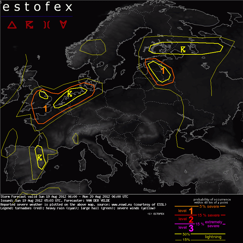
A level 1 was issued for NW France, Belgium, Netherlands, N Germany mainly for severe convective wind gusts and large hail (mostly during the night).
SYNOPSIS
Between a high pressure area over central Europe and an Atlantic low pressure system, a southerly flow advected a dramatic tongue of mid-level Saharan Air Layer far northward into western Europe. This leads to 2m temperatures in the 35-40 °C range while providing deep nearly dry-adiabatic lapse rates in the same area. At the western fringe of this area, over western France into Belgium and Netherlands, low-level water vapor accumulates under the influence of convergence in thermal troughs, leading to rather high CAPE values (1000-2000 J/kg). The other area of interest is a zone of less strong instability near a more active depression affecting southern Finland, Russia, Estonia and Latvia.
DISCUSSION
...NW France, Belgium, Netherlands, N Germany...
The main dynamics seem associated with warm air advection into a Biscay low coming to the English channel in the evening. Another thermal trough moves from the Netherlands in the early afternoon to N Germany/S Denmark but is not expected to do anyhing convective-wise.
The assessment of instability needs to take into account the differences in low-level mixing ratio between models. Since the airmass is of Saharan/Spanish origin, it is very dry and hot at 1 km altitude and the question is whether mixing ratio can get large enough for a parcel to become positively buoyant. Animation of the 0-1000m mixing ratio reveals an unrealistically strong afternoon increase in present GFS model runs (at least 2 g/kg between 09Z and 15Z). The 09Z mixing ratio looks normal can be extrapolated. So, 12-14 g/kg should be the corrected GFS indication. This agrees with the maximum areas in Hirlam and also with the 00Z Bordeaux, Brest and Santander soundings (13 g/kg in the BL). The problem is that not only this moisture is advected to the north, but also the hot layer above which serves as a cap unless 40°C is reached, or the cap eroded by layer lifting. However, lifting processes are forecast to be weak.
So, as observations as well as models indicate, LFC-LCL differences or CIN remain too high to allow surface-based convective storms, although an isolated elevated convective storm is not ruled out. While the afternoon and early evening may remain rather quiescent, there is now quite a good number of models supporting a late evening and night (21-06Z) thunder episode mainly over the Netherlands. (GFS, ECMWF, diverse WRF, Hirlam 18Z produces at 03-06Z).
The question is whether the 20 m/s DLS will be effective at night, Probably not, and then some 5-10 m/s must be subtracted. It will remain sufficient for organized multicells with severe gusts as the main threat, with large hail as secondary threat. There isn't particularly strong background dynamics going on so the main drive would be strong local cold pools/downdrafts caused by low mid-level theta-e and high LCLs (2000-3000m) - although GFS delta-theta-e (20-28°) is inflated due to the unrealistic low level moisture problem. Still 16-20° is probable. Tornadoes do not seem likely if convection remains elevated, and onion-shaped skew-t profiles (prog soundings) are too dry. Even though Hirlam (more than GFS) produces spots with more than 10 m/s 0-1 km shear.
Bron: ESTOFEX