WKN Weer, Klimaat en Natuurrampen
Lees alles over het onstuimige weer op onze planeet, volg orkanen en tornado's, zie hoe vulkanen uitbarsten en hoe Moeder Aarde beeft bij een aardbeving. Alles over de verwoestende kracht van onze planeet en tal van andere natuurverschijnselen.



Oftewel: all bets are offquote:Op dinsdag 2 april 2013 17:22 schreef stan12 het volgende:
This is a short blog post about the earthquake swarm in Tjörnes Fraction Zone.
The largest earthquake so far is a magnitude 5.5. The largest aftershocks so far are magnitude 4.4 that took place at 01:14 UTC and 4.7 that took place at 08:55 UTC this morning. This earthquake swarm is taking place on a complex fault area that is highly active. There is also big question what effect this earthquake swarm is going to have on other faults in the area. There is a risk that this earthquake swarm is going to start other earthquake swarms in nearby faults.
130402_1430
The earthquake activity in TFZ. Green stars are earthquakes that are larger then magnitude 3.0. Copyright of this image belongs to Icelandic Meteorological Office.
130402_1430_trace
This trace shows how dense this earthquake swarm has been. Copyright of this image belongs to Icelandic Meteorological Office.
bhrz.svd.02.04.2013.14.05.utc
The earthquake is appearing clearly on my geophone network. This is Böðvarshólar geophone station. This image is released under Creative Commons licence. Please see the CC Licence page for more details.
hkbz.svd.02.04.2013.14.05.utc
The largest earthquakes as they did appear on Heklubyggð geophone station. This image is released under Creative Commons licence. Please see the CC Licence page for more details.
There have been over 500 earthquake recorded since this earthquake swarm did start. It is impossible to know for sure when this earthquake swarm is going to stop, or if it is going to pick up again. But the earthquake swarm is already starting to shown signs of dropping activity. But that might change again if there is new larger earthquake in this area, or swarm of larger earthquake.
I am going to post update of anything major happens in this earthquake swarm. It is possible to monitor the current status of this earthquake swarm here on my geophone web page.
Bron: http://www.jonfr.com/volcano/
 en verder geen idee...
Dare to unleash my rage..
That's my secret Captain... I'm always angry...
There's nothing like a trail of blood, to find your way back home.
That's my secret Captain... I'm always angry...
There's nothing like a trail of blood, to find your way back home.


Denk niet dat er qua seismische activiteit in de zee heftige verschijnselen op kunnen treden aangezien de platen waar IJsland op ligt uit elkaar bewegen ipv dat er subductie plaatsvindt wat af en toe vast loopt en losschiet.

Swarm!quote:
De Borg komen er aan

Inorbit: zeg dat dan typluie triangeljosti
Beauregard: Een beetje FOK!ker laat het brood door z'n moeder smeren.
Ecosia
ek's 'n flash drive, jy's 'n floppy
Beauregard: Een beetje FOK!ker laat het brood door z'n moeder smeren.
Ecosia
ek's 'n flash drive, jy's 'n floppy

Update on the TFZ earthquake swarm at 18:31 UTC
Posted on April 3, 2013 by Jón Frímann
This is a short update on the TFZ earthquake swarm. There is no point in making a long update about what is taking place in TFZ at the moment. Since information gets outdated quickly during this earthquake swarm.
About 775 earthquakes have been recorded by Icelandic Meteorological Office since this earthquake swarm started on 2. April 2013 (about 48 hour period). This number is going to be outdated soon or already is outdated by the time this blog post gets published. Since there are about 40 – 60 earthquakes every 1 hour currently. The earthquake swarm however drops regularly in terms of activity. Over 80 magnitude 3.0 earthquakes have been recorded so far. This number is going to increase if this earthquake swarm continues as it has been doing for the past 48 hour period.
The earthquake activity in TFZ. The green stars show the earthquakes with larger magnitudes then 3.0. There is a second fault that has gone active since the earthquake activity started yesterday (02.04.2013). Copyright of this image belongs to Icelandic Meteorological Office.As can be seen here. The earthquake swarm has been really powerful at times. Copyright of this image belongs to Icelandic Meteorological Office.
This earthquake swarm is the largest one in the area for long time now. At the moment there are no sign about that this earthquake swarm is about to end any time soon.
skj20130403a
Map showing the largest earthquakes in this swarm. Copyright of this image belongs to Icelandic Meteorological Office.
gri.03.04.2013.16.58.utc
Earthquake activity as it appears on Grímsey SIL station. Copyright of this image belongs to Icelandic Meteorological Office.
skr.svd.03.04.2013.16.58.utc
Earthquake activity as it appears on Skrokkalda SIL station. Copyright of this image belongs to Icelandic Meteorological Office.
nor.svd.03.04.2013
Reviewed area of earthquake activity on TFZ. This map does not show the current earthquakes. It is few hours old also. Copyright of this image belongs to Icelandic Meteorological Office.
This earthquake swarm is complex and might last for a long time. There is a continued risk of a large earthquake in this area. But there has not been a earthquake larger then magnitude in this part of TFZ since 1910 at least. So this area has a lot of build up stress. Since there has not been a strong earthquake there for a long time. But the magnitude 5.5 earthquake and the following aftershocks have just released tiny amount of the stress that has build up in this area.
Map showing historical earthquake activity in TFZ. The image is from here. Copyright of this image belongs to Gunnar B. Gudmundsson, Pall Halldorsson, Ragnar Stefansson and other connected people.
For the moment. It is just best to keep watching the activity that is taking place in TFZ. It is impossible to know for sure what happens in TFZ during the next few hours to days.
Posted on April 3, 2013 by Jón Frímann
This is a short update on the TFZ earthquake swarm. There is no point in making a long update about what is taking place in TFZ at the moment. Since information gets outdated quickly during this earthquake swarm.
About 775 earthquakes have been recorded by Icelandic Meteorological Office since this earthquake swarm started on 2. April 2013 (about 48 hour period). This number is going to be outdated soon or already is outdated by the time this blog post gets published. Since there are about 40 – 60 earthquakes every 1 hour currently. The earthquake swarm however drops regularly in terms of activity. Over 80 magnitude 3.0 earthquakes have been recorded so far. This number is going to increase if this earthquake swarm continues as it has been doing for the past 48 hour period.

The earthquake activity in TFZ. The green stars show the earthquakes with larger magnitudes then 3.0. There is a second fault that has gone active since the earthquake activity started yesterday (02.04.2013). Copyright of this image belongs to Icelandic Meteorological Office.As can be seen here. The earthquake swarm has been really powerful at times. Copyright of this image belongs to Icelandic Meteorological Office.

This earthquake swarm is the largest one in the area for long time now. At the moment there are no sign about that this earthquake swarm is about to end any time soon.

skj20130403a
Map showing the largest earthquakes in this swarm. Copyright of this image belongs to Icelandic Meteorological Office.

gri.03.04.2013.16.58.utc
Earthquake activity as it appears on Grímsey SIL station. Copyright of this image belongs to Icelandic Meteorological Office.

skr.svd.03.04.2013.16.58.utc
Earthquake activity as it appears on Skrokkalda SIL station. Copyright of this image belongs to Icelandic Meteorological Office.

nor.svd.03.04.2013
Reviewed area of earthquake activity on TFZ. This map does not show the current earthquakes. It is few hours old also. Copyright of this image belongs to Icelandic Meteorological Office.
This earthquake swarm is complex and might last for a long time. There is a continued risk of a large earthquake in this area. But there has not been a earthquake larger then magnitude in this part of TFZ since 1910 at least. So this area has a lot of build up stress. Since there has not been a strong earthquake there for a long time. But the magnitude 5.5 earthquake and the following aftershocks have just released tiny amount of the stress that has build up in this area.

Map showing historical earthquake activity in TFZ. The image is from here. Copyright of this image belongs to Gunnar B. Gudmundsson, Pall Halldorsson, Ragnar Stefansson and other connected people.
For the moment. It is just best to keep watching the activity that is taking place in TFZ. It is impossible to know for sure what happens in TFZ during the next few hours to days.


As van Eyjafjallajökull zorgt voor enorme planktonboost
De uitbarsting van de IJslandse vulkaan Eyjafjallajökull zorgde drie jaar geleden niet enkel voor chaos in de luchtvaart, maar ook voor een enorme toename van de hoeveelheid plankton in de Atlantische Oceaan. Dat staat te lezen op de website van de Britse openbare omroep BBC.
Eind maart 2010 vertoonde de Eyjafjallajökull tekenen van vulkanische activiteit en op 14 april begon een explosieve uitbarsting. In grote delen van Europa werd het vliegverkeer dagenlang volledig stilgelegd vanwege de asdeeltjes in de atmosfeer, die de vliegtuigen konden beschadigen.
Op het leven in de oceaan had de uitbarsting een veel positievere invloed dan op de luchtvaart. In grote delen van het noordelijke stuk Atlantische Oceaan werden opgeloste ijzerdeeltjes afgezet, waardoor de hoeveelheid plankton, een microscopisch klein organisme, er enorm toenam. De toename was wel van korte duur, want de ijzerdeeltjes losten snel op.
"Onze studie was uniek in die zin dat we de eersten waren om stalen te nemen van vulkanische afzettingen in de zee, om de chemische en biologische effecten van de uitbarsting te onderzoeken", aldus wetenschapper Eric Achterberg in het wetenschappelijke magazine Geophysical Research Letters.
hln

De uitbarsting van de IJslandse vulkaan Eyjafjallajökull zorgde drie jaar geleden niet enkel voor chaos in de luchtvaart, maar ook voor een enorme toename van de hoeveelheid plankton in de Atlantische Oceaan. Dat staat te lezen op de website van de Britse openbare omroep BBC.

Eind maart 2010 vertoonde de Eyjafjallajökull tekenen van vulkanische activiteit en op 14 april begon een explosieve uitbarsting. In grote delen van Europa werd het vliegverkeer dagenlang volledig stilgelegd vanwege de asdeeltjes in de atmosfeer, die de vliegtuigen konden beschadigen.
Op het leven in de oceaan had de uitbarsting een veel positievere invloed dan op de luchtvaart. In grote delen van het noordelijke stuk Atlantische Oceaan werden opgeloste ijzerdeeltjes afgezet, waardoor de hoeveelheid plankton, een microscopisch klein organisme, er enorm toenam. De toename was wel van korte duur, want de ijzerdeeltjes losten snel op.

"Onze studie was uniek in die zin dat we de eersten waren om stalen te nemen van vulkanische afzettingen in de zee, om de chemische en biologische effecten van de uitbarsting te onderzoeken", aldus wetenschapper Eric Achterberg in het wetenschappelijke magazine Geophysical Research Letters.
hln
De 2 bevingen van gister zijn vandaag opgewaardeerd naar 1.3 en 0.9. Nu weer een beving van 1.1 en op 7.2km diepte.


quote:Minor glacier flood and steam explosion from Kverkfjöll volcano
In a announcement from Icelandic Meteorological Office, an minor glacier flood has now taking place from Kverkfjöll volcano, it appears to have started yesterday (15-August-2013). This is one of the minor glacier lakes in Kverkfjöll volcano. This glacier flood in minor and the water levels are not expected to reach more than normal summer level in the glacier river the flood is going into. The glacier river is called Volga and is a glacier river from Kverkfjöll volcano glacier area.
Currently Icelandic Meteorological Office is taking a trip over Kverkfjöll volcano to see the local changes and what is exactly is going on. Current status of the glacier flood is not well known, but latest report suggested that some subsiding was taking place, if that is because the glacier flood is over or something else is taking place I am not sure about at present time.
Update 1: Icelandic Civil Protection has confirmed that steam explosion took place in Kverkfjöll volcano following the glacier flood (due to sudden pressure release) that took place during the night and in the morning. News about that can be found here in Icelandic.


Allemaal tussen de 20 en 26km diepte. Ben benieuwd want ik heb sinds jaren geen bevingen gezien in de Katla op deze diepte. 4 Dagen geleden was er ook een Swarm ten zuid-oosten van de Katla op de zelfde diepte.
http://www.jonfr.com/volcano/ maar eens in de gaten houden
http://www.ijsland-enzo.nl/ijsland/actueel_nieuwspagina.aspquote:Er is een gletsjervloed gestart vanaf de Vatnajokull-gletsjer. Deze volgt de rivier Skafta. De waterverplaatsing is opgelopen van 80m3/sec 18-01 naar 370m3/sec 19-01 18:00.
Langs de rivier wordt een sterke zwavellucht geroken. Deze is zeer giftig. Mensen wordt om deze reden aangeraden, om NIET dicht bij de rivier te komen.
Het is nog onduidelijk of deze uitstroom gevolgen heeft voor de ringweg, maar de verwachting is van niet.
Deze gletsjervloed werd al weken verwacht.
De Skafta loopt van de Vatnajokull-gletsjer westelijk van Kirkjubaerjarklaustur naar zee.
Op dit moment 20-01 17:00 is de uitstroom alweer verminderd tot 350m3/sec. Er hebben zich geen problemen voorgedaan.
Zag afgelopen weekend nog een documentaire over Katla... erg boeiend... volgens mij was het op Nat.Geo of History... weet ik ff niet meer.
Dat was "How the earth works" op Discoveryquote:
Zag afgelopen weekend nog een documentaire over Katla... erg boeiend... volgens mij was het op Nat.Geo of History... weet ik ff niet meer.
 .
.Erg interessant om te zien. Ook leuk dat ze op de Solheimgletsjer liepen. Een maand geleden wandelde ik daar zelf ook namelijk
 .
.
Ah dat was um idd, Discovery dusquote:
[..]
Dat was "How the earth works" op Discovery
Erg interessant om te zien. Ook leuk dat ze op de Solheimgletsjer liepen. Een maand geleden wandelde ik daar zelf ook namelijk


Heb het net gedownload en gekeken, mooie docu. 
En meteen ook maar die van Krakatoa en Campi Flegrei gekeken.
En meteen ook maar die van Krakatoa en Campi Flegrei gekeken.
Webcam Heklaquote:Hekla Volcano “Could Erupt Soon
The magma chamber under volcano Hekla is now almost full, according to Páll Einarsson, professor in geophysics at University of Iceland.
Hekla, which is the most active volcano in Iceland, could erupt with very short notice, Páll told Morgunblaðið, adding that people should not climb the mountain.
During the last eruption, in 2000, it took just 79 minutes from the first quake until eruption, and Páll says that is longer than in previous eruptions.
Hekla has erupted more than 20 times in the last 1,000 years. The last big eruption in Hekla was in 1947.
Wat meer informatie
More magma in Hekla magma chamber then before 2000 eruption
Posted on March 17, 2014 by Jón Frímann
Send to Kindle
According to news today on mbl.is there is now more magma in Hekla volcano then before the 2000 eruption. The news says that since the year 2006 there has been more magma in Hekla magma chamber then before the last eruption in the year 2000. This has not meant an eruption so far. Hekla volcano magma chamber have the depth of around 10 to 20 km. This means this inflation that is now taking place does not appear clearly on the surface, but changes are being measured by GPS system that Icelandic Meteorological Office has. This is also appearing on GPS instruments that geological department University of Iceland has. Even if inflation is now more in Hekla volcano then during the eruptions in the year 1991 and 2000 it does not mean that next eruption is going to be bigger. Since the size of the eruption depends on how much of the magma is mobile in the magma chamber. That amount remains unknown until eruption takes place and even then not all of the mobile magma might erupt.
It is also pointed out in the news that it is risky to go on top of Hekla volcano as is. At least while no eruption has taken place currently. Since the risk of eruption is in place and the time from magma starts to move and until eruption takes place is short. Often less then 1 hour. It is advised in this news that people should not go on top of Hekla volcano. The risk is that eruption starts and trap people on top of the volcano, with deadly consequences.
It is possible to read the Icelandic news here. Please use Google Translate with care. It’s not always correct.
Kvikusöfnun meiri í Heklu en árið 2000 (mbl.is)
http://www.jonfr.com/volcano/
More magma in Hekla magma chamber then before 2000 eruption
Posted on March 17, 2014 by Jón Frímann
Send to Kindle
According to news today on mbl.is there is now more magma in Hekla volcano then before the 2000 eruption. The news says that since the year 2006 there has been more magma in Hekla magma chamber then before the last eruption in the year 2000. This has not meant an eruption so far. Hekla volcano magma chamber have the depth of around 10 to 20 km. This means this inflation that is now taking place does not appear clearly on the surface, but changes are being measured by GPS system that Icelandic Meteorological Office has. This is also appearing on GPS instruments that geological department University of Iceland has. Even if inflation is now more in Hekla volcano then during the eruptions in the year 1991 and 2000 it does not mean that next eruption is going to be bigger. Since the size of the eruption depends on how much of the magma is mobile in the magma chamber. That amount remains unknown until eruption takes place and even then not all of the mobile magma might erupt.
It is also pointed out in the news that it is risky to go on top of Hekla volcano as is. At least while no eruption has taken place currently. Since the risk of eruption is in place and the time from magma starts to move and until eruption takes place is short. Often less then 1 hour. It is advised in this news that people should not go on top of Hekla volcano. The risk is that eruption starts and trap people on top of the volcano, with deadly consequences.
It is possible to read the Icelandic news here. Please use Google Translate with care. It’s not always correct.
Kvikusöfnun meiri í Heklu en árið 2000 (mbl.is)
http://www.jonfr.com/volcano/

DeLuna vindt me dik ;(
Op zondag 22 juni 2014 12:30 schreef 3rdRock het volgende:
pas als jullie gaan trouwen. nu ben je gewoon die Oom Rubber die met onze mama leuke dingen doet :)
Op zondag 22 juni 2014 12:30 schreef 3rdRock het volgende:
pas als jullie gaan trouwen. nu ben je gewoon die Oom Rubber die met onze mama leuke dingen doet :)

Ik heb een tijd geleden gelezen dat ze denken dat het in 2014 t\m 2016 weer actiever wordt in IJsland. Volgend mij ook geschreven door onze vriend jon frimann.
Wat mij opvalt de laatste 2 maanden zijn de soms diepe bevingen in de Katla. Heb een tijdje geleden hier ook al over gepost.
Paar uur gelden weer eentje: Depth 28.9 km Magnitude 0.7
Heb in al die jaren nog nooit zo een diepe beving gezien in de Katla.
We blijven het volgen
Wat mij opvalt de laatste 2 maanden zijn de soms diepe bevingen in de Katla. Heb een tijdje geleden hier ook al over gepost.
Paar uur gelden weer eentje: Depth 28.9 km Magnitude 0.7
Heb in al die jaren nog nooit zo een diepe beving gezien in de Katla.
We blijven het volgen
quote:Hekla Volcano Eruption Hazard Signs Put Up
The police in South Iceland will erect in the area around Hekla several warning signs of a possible eruption in the volcano, Morgunblaðið reports.
The signs will be in both Icelandic and English with a QR-code to download the app for the 112 national emergency number so people can receive alerts if the sleeping volcano suddenly starts to erupt.
During the last eruptions, in 1970, 1980, 1991 and 2000, scientists only had between 30 and 80 minutes to send out a warning.
If the volcano starts to erupt, everyone in the vicinity of the volcano will receive an SMS warning in Icelandic and English.
mooie swarm in de Hekla
Depth Magnitude
6.8 km 0.3
7.8 km 0.6
14.2 km 0.6
9.4 km 0.7
6.9 km 0.4
5.1 km 0.5

Depth Magnitude
6.8 km 0.3
7.8 km 0.6
14.2 km 0.6
9.4 km 0.7
6.9 km 0.4
5.1 km 0.5
VolcanoDiscoveryquote:A small jökulhlaup (glacier outburst flood) started yesterday from the subglacial lake Grímsvötn and has been discharging into the river Gígjukvísl.
The event, which could have been triggered by normal fluctuations of hydrothermal activity under the ice is expected to be small. The Icelandic Met Office reports maximum discharge rates on the order of magnitude 1000 cubic meters per second, similar to rates during summer ice melt, and expects no damage to occur. The maximum of the flood is expected to be around the end of the week.
A small shallow earthquake swarm, probably as a result of adjustments in the ice mass above the draining lake, has accompanied the flood today. There are no indications that the flood was caused by a volcanic eruption of Grímsvötn volcano.
http://www.jonfr.com/volcano/?p=4456
http://en.vedur.is/earthquakes-and-volcanism/earthquakes/
Flinke swarm in de buurt van de Aksja vulkaan. Schijnt niet tektonisch te zijn maar allemaal met magma te verbonden te zijn.
Begint er weer in een vulkaan te borrelen? Het schijnt er al 1000 jaar rustig te zijn in dat gebeid....
http://en.vedur.is/earthquakes-and-volcanism/earthquakes/
Flinke swarm in de buurt van de Aksja vulkaan. Schijnt niet tektonisch te zijn maar allemaal met magma te verbonden te zijn.
Begint er weer in een vulkaan te borrelen? Het schijnt er al 1000 jaar rustig te zijn in dat gebeid....


laatste 2 weken steeds meer actie in de katla! Van 25km diepte tot aan het oppervlak zijn de bevingen
Ook vandaag weer.
Ook vandaag weer.

Update at 21:27 UTC on earthquake activity in Katla volcano
Posted on July 7, 2014 by Jón Frímann
Send to Kindle
This is a short update on what is now taking place in Katla volcano. This information might go outdated quickly after it is being written.
Currently the earthquake activity in Katla volcano is increasing. However there are no signs of imminent eruption as is. However that might change without notice under my current estimate. It is impossible to know if this activity in Katla volcano is going to continue to increase or slow down again. It is my estimate that activity in Katla volcano is going to continue to increase (based on past experience) before it quiets down again. That might not result in a eruption, since this type of activity does not mean that an eruption is going to take place. This activity in Katla volcano has increased that risk at current time and until this earthquake activity stops or gets to lower levels, that risk is going to remain higher then normal. As things stand now there are no signs of that an eruption is going to take place in Katla volcano.
140707_2017
The earthquake activity in Katla volcano during the past 48 hours. Copyright of this image belongs to Icelandic Meteorological Office.
During the minor eruption in Katla volcano in July-2011 (I wrote about it here and here) a minor earthquake swarm like this was also detected in Katla volcano. Back then as now it did start about one month earlier before the minor eruption took place. That activity took place in different part of the caldera then the activity that is now taking place. Today the activity in Katla volcano is the area that might have erupted during the 1918 eruption in Katla volcano (I think).
140706.234343.hkbz.psn
The magnitude 3,0 earthquake in Katla volcano yesterday. This image is under Creative Commons licence. Please see CC Licence page for more details.
This earthquake clearly shows the sign of magma under pressure creating a earthquake. This is a possibly a tornillo event. Since it is a low frequency, monochromatic and with long tale in it’s end. I don’t know what is going to happen next in Katla volcano, if anything happens at all other then just this earthquake activity. More water has been reported in Múlakvísl along with higher conductivity taking place, that however might just be rain water in the area since it has been experiencing heavy rain for the past few days. I am going to continue to watch the activity in Katla volcano.
Ook vandaag weer mee bevingen en zelfs eentje van 3.0
Posted on July 7, 2014 by Jón Frímann
Send to Kindle
This is a short update on what is now taking place in Katla volcano. This information might go outdated quickly after it is being written.
Currently the earthquake activity in Katla volcano is increasing. However there are no signs of imminent eruption as is. However that might change without notice under my current estimate. It is impossible to know if this activity in Katla volcano is going to continue to increase or slow down again. It is my estimate that activity in Katla volcano is going to continue to increase (based on past experience) before it quiets down again. That might not result in a eruption, since this type of activity does not mean that an eruption is going to take place. This activity in Katla volcano has increased that risk at current time and until this earthquake activity stops or gets to lower levels, that risk is going to remain higher then normal. As things stand now there are no signs of that an eruption is going to take place in Katla volcano.
140707_2017
The earthquake activity in Katla volcano during the past 48 hours. Copyright of this image belongs to Icelandic Meteorological Office.
During the minor eruption in Katla volcano in July-2011 (I wrote about it here and here) a minor earthquake swarm like this was also detected in Katla volcano. Back then as now it did start about one month earlier before the minor eruption took place. That activity took place in different part of the caldera then the activity that is now taking place. Today the activity in Katla volcano is the area that might have erupted during the 1918 eruption in Katla volcano (I think).
140706.234343.hkbz.psn
The magnitude 3,0 earthquake in Katla volcano yesterday. This image is under Creative Commons licence. Please see CC Licence page for more details.
This earthquake clearly shows the sign of magma under pressure creating a earthquake. This is a possibly a tornillo event. Since it is a low frequency, monochromatic and with long tale in it’s end. I don’t know what is going to happen next in Katla volcano, if anything happens at all other then just this earthquake activity. More water has been reported in Múlakvísl along with higher conductivity taking place, that however might just be rain water in the area since it has been experiencing heavy rain for the past few days. I am going to continue to watch the activity in Katla volcano.
Ook vandaag weer mee bevingen en zelfs eentje van 3.0
quote:Experts: Katla not erupting but stay away!
Geologists flew over Mýrdalsjökull glacier, which covers the active volcano Katla, yesterday to investigate sudden glacial flooding in Múlakvísl river and Jökulsá river, reports RÚV.
“It is obvious that [the floodwater] is originating from Katla, but there is nothing that points to a major event,” said geophysicist Björn Oddsson.
Although glacial flooding in the area is not expected to be heavy, travellers and tour companies are being told to stay vigilant of sudden rises in water levels and are advised to keep their distance by going no further than Múlakvísl river.
“In large quantities sulphur pollution [rising from the glacial flood] can be dangerous and people can pass out from it if they venture too close,” geologist Gunnar B. Guðmundsson told Vísir.
Glacial floods can be caused by any number of factors – rising lava, eruptions, steam vents or newly opened hot springs can all cause glacial ice to quickly melt, accumulate under the glacier, and then release. The effects can range from minor flooding to powerful destructive forces.
There have been no recorded earthquakes around Katla that might indicate an impending eruption though scientists will monitor the situation in the coming days.
Helga van Leur zit op IJsland momenteel, ze is aan de voet van de vulkaan geweest en bericht op haar Twitter ook over de 'veranderingen'. Verhoogde staat van paraatheid, ze ruikt de zwavelgeur etc.
https://twitter.com/helgavanleur
https://twitter.com/helgavanleur

quote:Earthquakes have been more frequent recently under the volcano recently. Most of them were small (below mag. 3) and shallow events. It is unknown whether these relate to magmatic movements inside the volcano, increased hydrothermal activity or are adjustments of the ice cap due to increased melting.
The government has declared "Uncertainty level" for Katla volcano yesterday. The largest hazard comes in the form of melt-water floods and sulfurous volcanic gasses dissolved in and released from glacial rivers.
People are advised not to stop at Múlakvísl and Jökulsá and other glacier river valleys and keep cell phones turned on in order to be able to receive potential SMS alerts.
Currently, there are no signs of an impending eruption at Katla.
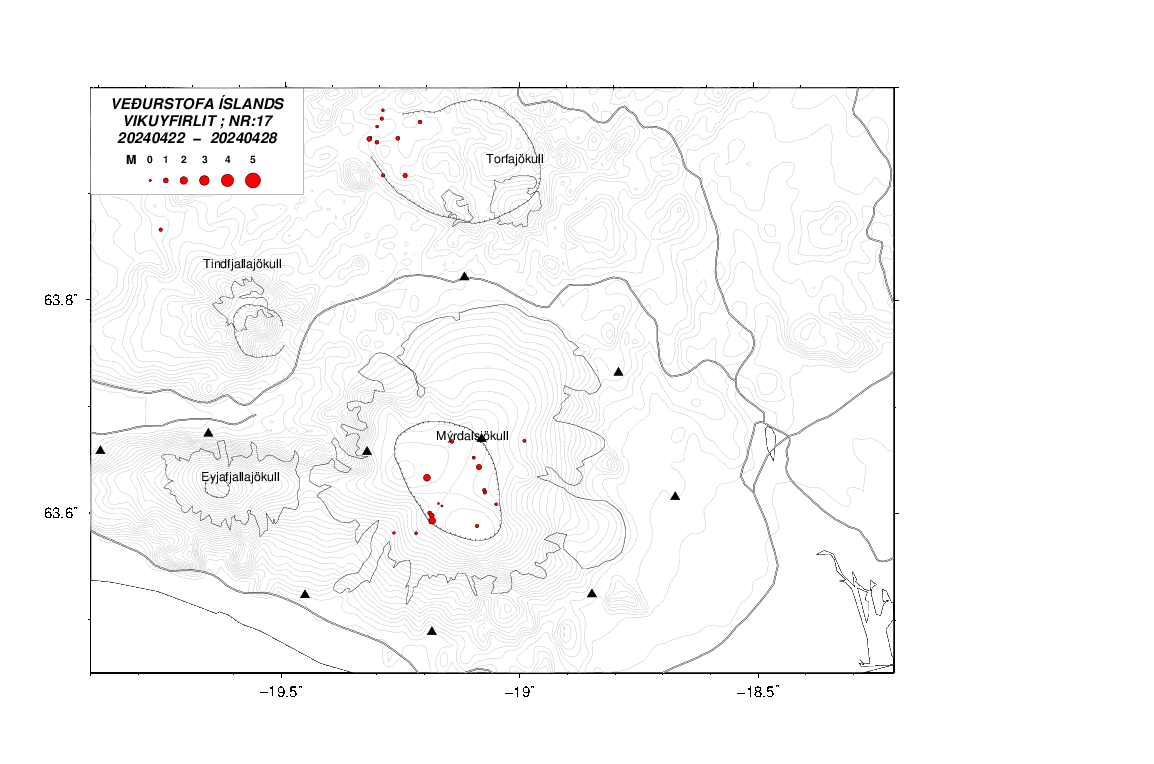
quote:How to keep things hot at Yellowstone and Katla: Just add water
Two volcanoes that get the interwebs all hot and bothered have made the news in the last week. First, Katla in Iceland produced some glacial flooding (jökulhlaups) that followed some earthquakes. Second, over at everyone’s favorite caldera, Yellowstone, there has been a lot of buzz over roads melting due to heat from the volcano. Now, as odd as it might seem, these two events are connected by the same process: geothermal (and hydrothermal) activity. When it comes down to it, most volcanoes are sitting on big heat sources. One way to lose the heat is by erupting, but probably the most important way to lose the heat is by the circulation of water in the crust. This water help keep things hot by efficiently moving heat generated by the magma that might be 5-6 kilometers (or more) below the surface and bringing it up to the surface — all of this happening when there is no threat of an eruption.
When you examine the history of a volcano, you’ll quickly see it spends much of its existence not erupting. However, during those periods of quiet between eruptions, there is plenty going on beneath the volcano. The magma is cooling and releasing heat and fluids in the surrounding rocks, causing the development of a hydrothermal system above the cooling magma. This is usually the top 5 kilometers of crust above the magma, where cracks in the rocks can help hot fluids rise from the magma and cool fluids (like rainwater or snowmelt) percolate down into the crust and heat up. So, how hot does it get under a volcano? Well, by examining the exposed innards of extinct volcanoes, we can see how much alteration the rocks and minerals have experienced. This is an important step in understand how certain valuable ore deposits, like porphyry copper, form above bodies of magma under volcanoes.
Looking at these zones of hydrothermal alteration, it is clear that the subsurface temperatures get hot — upwards of 300-500°C even multiple kilometers above any cooling magma body. Now, that heat isn’t getting there by conduction alone. Rock isn’t a very good conductor, so heat won’t travel far. However, if you heat up water traveling through cracks in the rock, you can transport a lot of heat upwards. That’s because water has a high heat capacity – think about how the Gulf Stream brings warm water from the tropics to the North Atlantic to keep Europe warm. That is what allows all the alteration to occur and for hydrothermal systems to form. These hydrothermal systems are constantly changing based on the seasons (thanks to changing access to water percolating into the crust), seismicity that opens and closes cracks and yes, even magma moving. However, most of the time, the changes in the system are merely due to new routes these hot fluids take to reach the surface.
What are the manifestations of these hydrothermal fluids? You see some of them at most active volcanoes: steam vents (fumaroles), hot springs, geysers, mud pots. Each is a different way heat escapes the ground. Steam vents tend to be the hottest, releasing steam (with other volcanic gases) at temperatures of 300-500°C. Geysers are explosions of superheated water, so they will be ~100°C. Hot springs and mud pots tend to be much cooler, with temperatures usually 20-70°C, depending of the vigor of the spring or geyser.
Glacial flooding from underneath Mýrdalsjökull in Iceland, seen at Múlakvísl. Photo by the Icelandic Met Office.
Glacial flooding from underneath Mýrdalsjökull in Iceland, seen at Múlakvísl. Photo by the Icelandic Met Office.
So, even moving water through the crust can bring a lot of heat upwards and that is common at most volcanoes — as are changes in the hydrothermal system over time. So, what is happening at Katla and Yellowstone?First, at Katla, the hydrothermal system works underneath a large ice cap (Mýrdalsjökull). Especially during warmer months, more water can percolate into the crust, causing changes in the hydrothermal system (which, by itself, can generate earthquakes). If more heated water and steam is allowed to reach the surface, then more ice can melt and pond until it is catastrophically released as a flood. Reports from the Iceland Met Office support this idea – the waters are warm as they come out from under the glacier. However, unlike an eruption-driven event, the melting isn’t accompanied by a continuously increasing number of earthquakes that would betray magma moving. So, the most likely explanation for these floods is increasing melting due to changes in the hydrothermal (geothermal) system, not an eruption. These sorts of floods have happened before during this time of year at Katla, sometimes more dramatic than others.
Now, at Yellowstone, we have a different manifestation of the same thing. The news has splashed images of melting roads on Firehole Lake Drive in an area with intense hydrothermal activity. The usual suspects (e.g., the Yellowstone disaster groupies) want to say this is evidence that an eruption is in the works. Well, again, sorry to disappoint the lunatic fringe, but it isn’t. Instead, this is a sign that the hydrothermal system under Firehole Lake Drive has shifted some — maybe due to the constant seismicity that gently shakes Yellowstone, maybe due to the water table, maybe even due to the road itself — and now heat is coming up directly under the road. Now, asphalt like that can melt at temperatures as low at ~50-70°C, so well within the range of most hydrothermal features. Measures of the road surface by NPS workers are ~70°C, so we’re well within the range of temperatures needed to melt the road. Just move where that hot spring or fumarole is coming up and boom, you have heat under the road, melting it.
quote:Update on Katla
Few days ago the uncertainty level around glacier rivers that come from Mýrdalsjökull glacier have been cancelled. However the area remains dangerous due to gases that might collect in pockets in low lying areas. So it is not safe to go close to the glacier rivers from Mýrdalsjökull glacier even if the uncertainty level has been cancelled by the authorities.
Today (15-July-2014) an earthquake swarm took place in Katla volcano. Largest earthquake in this swarm had the magnitude of 3,1. Other earthquake that happened where smaller. This earthquake swarm is one of the most dense in the past few weeks and it appears that earthquake activity is once again on the rise in Katla volcano. I am now expecting this earthquake activity to continue. I also think there is a high risk of small eruptions within the Katla volcano caldera. This eruptions would only last for few hours at the most and not even break trough the Mýrdalsjökull glacier. It has to be noted that scientist on duty at Icelandic Meteorology Office does not agree with my opinion. While there is a high risk of this (in my opinion) that this might happen, it does not mean it is going to do so. The best thing that can be done for now is to observe activity in Katla volcano.
If anything more happens. I am going to post update on it soon as possible. Any large earthquakes that happen in Katla volcano do appear clearly on my geophone at Heklubyggð and they can be viewed here. There is also a web camera of Katla / Eyjafjallajökull located here.
http://en.vedur.is/earthquakes-and-volcanism/earthquakes/vatnajokull/#view=table
Earthquake swarms and raised alert for Baroarbunga.
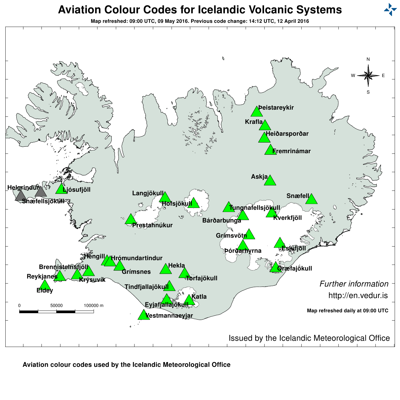
Earthquake swarms and raised alert for Baroarbunga.
PVDA-PTB lid. Sanders supporter. Student psychologie. Interesse voor films, sport, geschiedenis, multimedia, wereldpolitiek, geologie en het weer.
Ik heb er een artikel over gemaakt op mijn site:
http://www.geoweather.eu/vulkanen/verhoogde-alertstatus-voor-bardarbunga/
http://www.geoweather.eu/vulkanen/verhoogde-alertstatus-voor-bardarbunga/
PVDA-PTB lid. Sanders supporter. Student psychologie. Interesse voor films, sport, geschiedenis, multimedia, wereldpolitiek, geologie en het weer.

Ik zat net te kijken op en.vedur.is omdat ik dinsdag op vakantie ga naar IJsland. Zag dit inderdaad ook voorbij komen. Ik hou dit topic even in de gaten!
Wer lesen kann, ist klar im Vorteil.
http://www.jonfr.com/volcano/
Onze IJslandse collega is ook wakkergeschoten met twee berichten. Hij spreekt over een mogelijke eruptie onder de gletsjer.
Blijven opvolgen dus. De media springt er nog niet op in, wellicht doordat de vulkaan niet zo bekend is.
Onze IJslandse collega is ook wakkergeschoten met twee berichten. Hij spreekt over een mogelijke eruptie onder de gletsjer.
Blijven opvolgen dus. De media springt er nog niet op in, wellicht doordat de vulkaan niet zo bekend is.
PVDA-PTB lid. Sanders supporter. Student psychologie. Interesse voor films, sport, geschiedenis, multimedia, wereldpolitiek, geologie en het weer.
Ik zie er wel berichten over staan in de IJslandse online media. Maar de vertalingen daarvan zijn zo onduidelijk dat je er ook niet heel veel extra info uit kunt halen.
Wer lesen kann, ist klar im Vorteil.
http://en.vedur.is/about-imo/news/nr/2936
Op twitter is de storm nu ook begonnen, zowel met de IJslandse als de Engelse benaming.
Op twitter is de storm nu ook begonnen, zowel met de IJslandse als de Engelse benaming.
PVDA-PTB lid. Sanders supporter. Student psychologie. Interesse voor films, sport, geschiedenis, multimedia, wereldpolitiek, geologie en het weer.
In the past few hours the harmonic tremors around Bárðarbunga volcano have been dropping slowly. The drop in harmonic tremor has not been followed by drop in earthquake activity. At least that is not the case when this is written. This means that the magma that is on the move there still has not yet found a pathway to the surface, even if some small part of it has done so in possibly in one or two eruptions vents under the thick glacier. If the harmonic tremor stops completely without the earthquake activity stopping it means that magma is still on the move there and it might look for a new pathway to the surface. When and where that might happen is impossible to know at current time, but once the magma has clear path to the surface, even if it is under a glacier all earthquake activity is going to stop (for most part).
http://www.jonfr.com/volcano/?p=4683
http://www.jonfr.com/volcano/?p=4683
Earthquake activity continues in Bárðarbunga volcano and shows no signs of slowing down. Two swarms have appeared in Bárðarbunga volcano system. One is at location called Kistufell, while the second one is at the south-east part of the Bárðarbunga volcano. Increase in earthquake activity in south-east part of Bárðarbunga volcano seems to increase harmonic tremor. I am not sure why that is. As of now (when this is written) no eruption has been confirmed in Bárðarbunga volcano, the volcano is under glacier so confirmation is difficult at best.
Earthquake activity in Bárðarbunga volcano. The two groups of earthquake swarms are visible on this map. Copyright of this image belongs to Icelandic Met Office.
Earthquake activity has been dense as can be seen here. Copyright of this image belongs to Icelandic Met Office.
Harmonic tremor remains high on the Dyngjuháls SIL station. Why that is not clear at the moment. Copyright of this image belongs to Icelandic Met Office.
Harmonic tremor remains high at Vonarskarð SIL station. It has dropped little during the day, but it remains constant at current time. Copyright of this image belongs to Icelandic Met Office.
So far no major eruption has started in Bárðarbunga volcano. That might change without warning as this activity continues. There is a risk of large earthquakes taking place before such eruption. Since the crust in this part of Iceland is thick (up to 40 km thick) and last eruption in Bárðarbunga volcano took place in the year 1794. The eruption in the year 1910 took place in a volcano named Hamarinn and is south-west of Bárðarbunga volcano. Fissure eruptions are also a feature that Bárðarbunga volcano has, if this activity is going to result in such eruption is something that is impossible to know at current time.
http://www.jonfr.com/volcano/ (bericht wel volledig overgenomen nota bene op 4 uur gepost vannacht

Earthquake activity in Bárðarbunga volcano. The two groups of earthquake swarms are visible on this map. Copyright of this image belongs to Icelandic Met Office.

Earthquake activity has been dense as can be seen here. Copyright of this image belongs to Icelandic Met Office.

Harmonic tremor remains high on the Dyngjuháls SIL station. Why that is not clear at the moment. Copyright of this image belongs to Icelandic Met Office.

Harmonic tremor remains high at Vonarskarð SIL station. It has dropped little during the day, but it remains constant at current time. Copyright of this image belongs to Icelandic Met Office.
So far no major eruption has started in Bárðarbunga volcano. That might change without warning as this activity continues. There is a risk of large earthquakes taking place before such eruption. Since the crust in this part of Iceland is thick (up to 40 km thick) and last eruption in Bárðarbunga volcano took place in the year 1794. The eruption in the year 1910 took place in a volcano named Hamarinn and is south-west of Bárðarbunga volcano. Fissure eruptions are also a feature that Bárðarbunga volcano has, if this activity is going to result in such eruption is something that is impossible to know at current time.
http://www.jonfr.com/volcano/ (bericht wel volledig overgenomen nota bene op 4 uur gepost vannacht
PVDA-PTB lid. Sanders supporter. Student psychologie. Interesse voor films, sport, geschiedenis, multimedia, wereldpolitiek, geologie en het weer.
