WKN Weer, Klimaat en Natuurrampen
Lees alles over het onstuimige weer op onze planeet, volg orkanen en tornado's, zie hoe vulkanen uitbarsten en hoe Moeder Aarde beeft bij een aardbeving. Alles over de verwoestende kracht van onze planeet en tal van andere natuurverschijnselen.


quote:Russian Volcano Erupts After 36 Years of Inactivity
VLADIVOSTOK -- The Interfax news agency said the Plosky Tolbachik volcano started erupting on Tuesday night. It was the volcano's first eruption since 1976. Located in the Kamchatka Peninsula, the 3,085-meter high volcano erupted and spewed an ash column seven km. into the atmosphere. The ash cloud then started to move northwest as lava oozes down the southern slope of the volcano. The volcanic ash later fell in the villages of Krasny Yar and Maiskoye, creating a layer that is about four centimeters thick. The eruption prompted authorities to issued an orange alert although there is no significant risk to any populated area. Plosky Tolbachik is located in the southwestern section of the Klyuchevsky group of volcanoes in eastern Kamchatka and approximately 343 km. away from Petropavlovsk-Kamchatsky. Authorities observed a considerable increase in seismic activity and registered more than 130 volcanic tremors at Plosky Tolbachik.

In Ecuador wel.. (is een ander topic over )quote:Op dinsdag 11 december 2012 19:21 schreef summer2bird het volgende:
En, zijn de vulkanen al een beetje op gang voor 21 december?
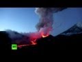
betreft volgens mij de Plosky Tolbachik van iets hierbovenquote:A volcano which started erupting in far east Russia late last month continued to spew lava, plumes of ash and smoke into the air on Sunday. The volcano has attracted tourists to the region despite temperatures down to minus 30 Celsius (minus 86 Fahrenheit). Local residents and tourists have been warned by authorities against visiting the area, citing the danger of hot lava and poisonous gases that come to the surface during the eruption


Ik bedacht me een interessante vraag. Als vaste volger van alles wat er met vulkanen te maken heeft....
Wat is eigenlijk de laagste vulkaan op land boven zee-niveau?
Mauna Kea, Hawaii is de hoogste berg ter wereld. De vulkaan komt 4205 meter boven de zeespiegel uit.
Masaya in Nicaragua is 635 m.
Zijn er lagere?
Wat is eigenlijk de laagste vulkaan op land boven zee-niveau?
Mauna Kea, Hawaii is de hoogste berg ter wereld. De vulkaan komt 4205 meter boven de zeespiegel uit.
Masaya in Nicaragua is 635 m.
Zijn er lagere?
In Afrika, ethiopie, ligt er volgens mij eentje onder zeeniveau op land. Geen idee verder. Google is ur vriend denk ik :p
De laagst gelegen vulkaan op het land onder zeeniveau is (als ik het goed gelezen heb)quote:Op dinsdag 1 januari 2013 21:12 schreef 1boefje het volgende:
Ik bedacht me een interessante vraag. Als vaste volger van alles wat er met vulkanen te maken heeft....
Wat is eigenlijk de laagste vulkaan op land boven zee-niveau?
Mauna Kea, Hawaii is de hoogste berg ter wereld. De vulkaan komt 4205 meter boven de zeespiegel uit.
Masaya in Nicaragua is 635 m.
Zijn er lagere?
Dallol met 45 meter.
Danakil Depression, northeast of the Erta Ale Range in Ethiopia.
<a href="http://www.vwkweb.nl/" rel="nofollow" target="_blank">[b]Vereniging voor weerkunde en klimatologie[/b]</a>
<a href="http://www.estofex.org/" rel="nofollow" target="_blank">[b]ESTOFEX[/b]</a>
<a href="http://www.estofex.org/" rel="nofollow" target="_blank">[b]ESTOFEX[/b]</a>
Thanks,
ik ga eens even kijken hoe dat precies komt. Is het de 'leeftijd', het materiaal wat de vulkaar uitstoot (of niet). Ik vind het best interessant. Een 5 km hoge vulkaar ga je namelijk niet zo snel beklimmen, maar de Masaya, daar waren we zo boven....
Google was this time not my best friend......
ik ga eens even kijken hoe dat precies komt. Is het de 'leeftijd', het materiaal wat de vulkaar uitstoot (of niet). Ik vind het best interessant. Een 5 km hoge vulkaar ga je namelijk niet zo snel beklimmen, maar de Masaya, daar waren we zo boven....
Google was this time not my best friend......
Dat zijn vulkanen die wederom net boven de zeespiegel uit aan het komen zijn. Bijvoorbeeld dat ding bij de canarisch eilanden die aan het bubbelen is als die eenmaal boven de zee uitkomt is die het laagste.quote:
Ik bedacht me een interessante vraag. Als vaste volger van alles wat er met vulkanen te maken heeft....
Wat is eigenlijk de laagste vulkaan op land boven zee-niveau?
Mauna Kea, Hawaii is de hoogste berg ter wereld. De vulkaan komt 4205 meter boven de zeespiegel uit.
Masaya in Nicaragua is 635 m.
Zijn er lagere?
De anak krakatau is ook niet zo hoog,189 meter: http://nl.wikipedia.org/wiki/Anak_Krakatau
Dallol is echt heel apart! Mooi.
Basp1, ik had het niet over eilanden (vulkanen omringt door zee), maar echt op een continent.
Basp1, ik had het niet over eilanden (vulkanen omringt door zee), maar echt op een continent.
Continenten zijn ook ontstaan door vulkanische activiteit. Dan zou je ook hawai natuurlijk niet mee moeten nemen in de uitleg van je eerdere vraag.quote:
Dallol is echt heel apart! Mooi.
Basp1, ik had het niet over eilanden (vulkanen omringt door zee), maar echt op een continent.
Of je moet hem goed lezen, LOL.
Wat is eigenlijk de laagste vulkaan op land boven zee-niveau?
Mount Fuji dan ipv Hawaii :-p
Maar dan klopt het antwoord ook weer niet, Dallol ligt echt op land onder zeeniveau...
Hahaha
Snap er zelf niks meer van
Wat is eigenlijk de laagste vulkaan op land boven zee-niveau?
Mount Fuji dan ipv Hawaii :-p
Maar dan klopt het antwoord ook weer niet, Dallol ligt echt op land onder zeeniveau...
Hahaha
Snap er zelf niks meer van
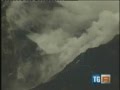
Laatste week zouden er tien (nieuwe) actieve vulkanen zijn bij gekomen. Op het Russisch grondgebied is het op dit moment het 'drukste' . Negen vulkanen zijn daar nu actief.quote:Verhoogde activiteit bij de Stromboli
Sinds vier dagen neemt de activiteit van de vulkaan Stromboli toe in intensiteit. Het gelijknamige eiland in de Tyrrheense Zee is gehuld in een enorme rookwolk afkomstig van de vulkaan, zo meldt het Italiaanse geofysisch instituut.
De vulkaan is weliswaar permanent actief, maar zondagnacht vond een zware explosie plaats, waarna een lavastroom naar zee vloeide. Acht uur later was een enorme rookwolk te zien, vergezeld van een nieuwe lavastroom. De afgelopen uren werden 23 seismische bewegingen waargenomen.
Burgemeester Marco Giorgianni van Stromboli heeft zijn 500 burgers al laten weten dat de situatie onder controle is en dat ze geen enkel risico lopen. Het Italiaanse geofysisch en vulkanologisch instituut volgt de situatie op de voet.
WKN / Russische vulkaanuitbarstingen: Wereldwijde zorgen?


quote:Japanese scientist predicts Mount Fuji to erupt by 2015
Ever since the Great East Japan Earthquake of 2011, seismologists and volcanologists have been keeping a close eye on Mount Fuji. According to Masaki Kimura, a professor emeritus at Ryukyu University, signs are pointing to an imminent explosion by 2015.
He says the volcano should have erupted in 2011 as well, but there is a usual four-year margin of error, which should run out by 2015. Also, the experts monitoring the activity of the volcano says its “magma chamber pressure” had risen to 1.6 megapascals. This is higher than the chamber pressure that preceded its last eruption more than 300 years ago, which was triggered by a massive earthquake near Osaka a month before.
Kimura also says that magma is rising from beneath Mt. Fuji and cracks in the crust have been increasing. Other signs to its impending eruption are the rising water level of nearby Lake Sai, numerous steam explosions and the increasing number of volcanic earthquakes. The partial collapse of the Sasago expressway tunnel in December last year which killed nine people wasn’t caused by an earthquake but may have been triggered by the deformation of the tunnel, which Kimura believes to be connected to Mt Fuji activity where “some things hanging above have been falling”.
In 2012, a huge fault line measuring 21 miles was discovered beneath Mt. Fuji and an earthquake along that fault line could actually cause the volcano to collapse entirely. Experts speculate that in the eventuality of an explosion, cost to human life would be low (due to slow-moving lava) but the damage to public and private property will be huge.
quote:Fuji eruption could force 567,000 people to evacuate
SHIZUOKA – An eruption of Mount Fuji could force some 567,000 people to evacuate their homes, according to a new estimate.
The projection is part of an evacuation plan crafted by the Shizuoka Prefectural Government that also says more than 130,000 people, comprising some 50,000 households, would have to relocate if lava were to reach residential districts in the city of Fuji, which lies just south of the 3,776-meter mountain.
Depending on the number and locations of vents, evacuation from wider areas could be needed. The plan is based on a hazard map prepared by the central government based on Fuji’s last eruption, in 1707.
Under the evacuation plan, 10 zones have been designated at the foot of the mountain based on the expected direction of lava flows.
The plan specifies evacuation zones in four grades.
The Yamanashi Prefectural Government is preparing a similar evacuation plan.
Plans will be finalized at a consultation forum involving Shizuoka, Yamanashi and Kanagawa prefectures and the central government. Joint evacuation drills in the three prefectures will also be conducted.

<a href="http://www.vwkweb.nl/" rel="nofollow" target="_blank">[b]Vereniging voor weerkunde en klimatologie[/b]</a>
<a href="http://www.estofex.org/" rel="nofollow" target="_blank">[b]ESTOFEX[/b]</a>
<a href="http://www.estofex.org/" rel="nofollow" target="_blank">[b]ESTOFEX[/b]</a>
quote:Alertlevel at Sabancaya (Peru) volcano raised to orange
Over the past few days, the Peruvian Geologic Survey (Ingemmet) has noted a sharp increase in seismicity underneath one of the more active volcano’s in the southern part of the country: Sabancaya. Over 500 earthquakes were recorded under the volcano between February 22-23 and with an accompanying increase in fumarole emissions (steam and volcanic gases) from the summit (see above), Ingemmet chose to raise the alert status at Sabancaya to Orange. The fumarolic activity at the summit is especially notable the new steam/gas plume reached over 100 meters over the volcano (although this can also be mitigated by weather conditions) — and closely followed the onset of the new seismicity.
Interestingly, before this new seismic swarm and fumarolic activity began, I noted on Twitter an interesting sequence of earthquakes near Sabancaya. On February 22, three M4.9-5.3 earthquakes struck within 2 hours of each other ~30-40 km to the northeast of the volcano (see below). All these earthquakes were fairly shallow (10-18 km) — in fact, much shallow than much of the historic seismicity in the area. I noted the earthquakes because of their location between Sabancaya and another large Peruvian volcano, El Misti. Now, this is where we have to worry about chickens and eggs — there is no evidence for a connect between these earthquakes and the new unrest at Sabancaya. [SPECULATION] However, it does leave open the potential that (a) the earthquakes could have triggered this new unrest or (b) the earthquakes are part of the new unrest. Under option (a), these earthquakes might not have been directly related to magmatic activity/movement, but their proximity to Sabancaya disturbed the magmatic or hydrothermal system at the volcano. Under option (b), these earthquakes could be the intrusion of a new batch of magmatic itself — however, their distance from Sabancaya seems a little far for that to be the case. My [wild] hunch here might be that the three earthquakes might have “jostled” the hydrothermal system at Sabancaya, producing an increase in hydrothermal flow leading to more intense fumaroles and resulting in an earthquake swarm as the hydrothermal system re-establishes itself. Now, this is not to say that magma movement under the volcano isn’t a potential cause as well — as Ingemmet collects more data, such as the types/amounts of volcanic gases in the fumaroles and can survey the volcano looking for deformation, their geologists can then make a more definitive statement about the nature of the unrest at Sabancaya. Jersy Mariño Salaza from Ingemmet did, however, mention that this unrest is similar to the unrest prior to the volcano’s eruptions in the late 1980s and early 1990s.


quote:Alaska volcano threatens to blow
Anchorage - Another volcano in Alaska is heating up, with seismic instruments signalling a possible eruption.
The Alaska Volcano Observatory says tremors were detected Monday at Pavlof Volcano, 1 000km southwest of Anchorage.
John Power, the US Geological Survey scientist in charge at the observatory, said satellite imagery shows the volcano is "very, very hot".
Pavlof is 60km from the community of Cold Bay. The volcano last erupted in 2007.
It's the second Alaska volcano to rumble this month.
Cleveland Volcano, on an uninhabited island in the Aleutian Islands, experienced a low-level eruption in early May.
Power said satellite imagery shows the volcano continues to discharge steam, gas and heat, although no ash clouds have been detected in the past week.
Cleveland is not monitored with seismic instruments.