WKN Weer, Klimaat en Natuurrampen
Lees alles over het onstuimige weer op onze planeet, volg orkanen en tornado's, zie hoe vulkanen uitbarsten en hoe Moeder Aarde beeft bij een aardbeving. Alles over de verwoestende kracht van onze planeet en tal van andere natuurverschijnselen.


2 systemen bij Australie. Hoge kans dat deze een cycloon gaan worden.

quote:Potential Cyclones:
At 2pm WST a developing tropical low [16U] was located near 19.1S 112.7E, about
350 kilometres north northwest of Exmouth and moving towards the west southwest
at 24 kilometres per hour. Refer to the latest Tropical Cyclone Advice
[IDW24100] for details.
Likelihood of this system being a tropical cyclone in the Western Region:
Wednesday :High
Thursday :High
Friday :High
quote:Potential Cyclones:
A developing Tropical Low, 1002 hPa, was located over the western Top End near
13.2S 130.5E, approximately 100km south southwest of Darwin at 12:30 pm CST on
15 February and moving slowly west northwest. The low is expected to move north
or north northwest into the Beagle Gulf and may develop into a tropical cyclone
during Wednesday.
Likelihood of this system being a tropical cyclone in the region on:
Wednesday: High.
Thursday: High.
Friday: High.

Orkaanseizoen in één minuut
Het was vorig jaar een druk orkaanseizoen in de Atlantische regio. Sinds 2005 - het jaar van orkaan Katrina - waren er nooit meer orkanen. Liefst twaalf stormen werden in 2010 tot orkaan uitgeroepen. Dit filmpje toont het hele seizoen in één minuut.
Het orkaanseizoen was vorig jaar ook opmerkelijk, omdat voor het eerst sinds 1998 nog eens drie orkanen tegelijk actief waren. Igor, Julia en Karl kregen die eer. Igor en Julia waren zelfs samen een orkaan van categorie 4 en dat was sinds 1926 niet meer gebeurd. (gb)
hln
[ Bericht 15% gewijzigd door #ANONIEM op 15-02-2011 19:14:11 ]
Het was vorig jaar een druk orkaanseizoen in de Atlantische regio. Sinds 2005 - het jaar van orkaan Katrina - waren er nooit meer orkanen. Liefst twaalf stormen werden in 2010 tot orkaan uitgeroepen. Dit filmpje toont het hele seizoen in één minuut.
Het orkaanseizoen was vorig jaar ook opmerkelijk, omdat voor het eerst sinds 1998 nog eens drie orkanen tegelijk actief waren. Igor, Julia en Karl kregen die eer. Igor en Julia waren zelfs samen een orkaan van categorie 4 en dat was sinds 1926 niet meer gebeurd. (gb)

hln
[ Bericht 15% gewijzigd door #ANONIEM op 15-02-2011 19:14:11 ]


Ziet er gaaf uit zegquote:Op dinsdag 15 februari 2011 19:11 schreef aloa het volgende:
Orkaanseizoen in één minuut
Het was vorig jaar een druk orkaanseizoen in de Atlantische regio. Sinds 2005 - het jaar van orkaan Katrina - waren er nooit meer orkanen. Liefst twaalf stormen werden in 2010 tot orkaan uitgeroepen. Dit filmpje toont het hele seizoen in één minuut.
Het orkaanseizoen was vorig jaar ook opmerkelijk, omdat voor het eerst sinds 1998 nog eens drie orkanen tegelijk actief waren. Igor, Julia en Karl kregen die eer. Igor en Julia waren zelfs samen een orkaan van categorie 4 en dat was sinds 1926 niet meer gebeurd. (gb)
hln
Doe mee met het voorspellen van het weer!
Weekvoorspelling | Week 12 (invullen tot 16-03 - 11:59)
Maandvoorspelling Maart (Inzendingen gesloten)
Jaarvoorspelling 2025 / 2026
Weekvoorspelling | Week 12 (invullen tot 16-03 - 11:59)
Maandvoorspelling Maart (Inzendingen gesloten)
Jaarvoorspelling 2025 / 2026
Nieuwe cycloon raast over Noord-Australië
(Novum/AP) - De cycloon Carlos heeft in de Noord-Australische stad Darwin voor hevige regenval en windstoten met snelheden tot 130 kilometer per uur gezorgd. Bomen en elektriciteitspalen gingen tegen de vlakte.
Verscheidene mensen moesten uit hun auto gered worden en één man raakte gewond toen hij door een vallende boom werd geraakt. Scholen en overheidsgebouwen sloten hun deuren, maar evacuaties waren niet nodig, aldus de autoriteiten.
Het oog van de storm liep op drie kilometer langs de stad, maar bleef wel boven zee. Volgens de nationale meteorologische dienst kan de cycloon donderdag terugkeren naar Darwin.
Twee weken geleden verwoestte de veel krachtigere cycloon Yasi meerdere steden in de noordoostelijke staat Queensland.
Nieuws.nl
Cycloon Carlos raast door Australische stad Darwin
De Australische stad Darwin, in het noorden van het land, is vandaag getroffen door de cycloon Carlos. Rukwinden van 110 kilometer per uur en hevige regen teisterden de stad.
Verschillende scholen en de luchthaven werden gesloten terwijl de stad met 120.000 inwoners getroffen werd door overstromingen en stroomonderbrekingen, zo melden lokale media. Volgens tv-zender ABC liepen de straten onder water en werden bomen uit de grond gerukt. Naar verluidt vielen er geen gewonden.
Op een schaal van een tot vijf werd Carlos geklasseerd als een categorie 1, aldus de meteorologische diensten. De cycloon volgt twee weken na de gelijkaardige storm Yasi, die voor 1 miljard Australische dollar aan schade veroorzaakt heeft. (afp/adv)
HLN
564 mm in 56 uur tijd 
[ Bericht 0% gewijzigd door #ANONIEM op 16-02-2011 14:55:59 ]
bronquote:Darwin residents warned to prepare but not panic
Tropical Cyclone Carlos is continuing to dump record levels of rain on Darwin as the city's residents deal with cyclonic weather.
More than 400 millimetres of rain fell on the city overnight, forcing the evacuation of 11 houses, and emergency services are preparing to use sandbags to protect more houses which face flooding when the tide peaks tonight.
At this stage the cyclone isn't expected to intensify above category two but the Top End does have a reputation for unpredictable cyclones. Michael Coggan reports from Darwin.
MICHAEL COGGAN: Darwin is familiar with cyclones; rarely does a wet season go by without one or two cyclones reminding Top Enders of the destruction caused by Cyclone Tracy in 1974. But Cyclone Carlos is different, even before it was officially declared a cyclone the weather system cut a swath through the Top End capital.
The combination of more than 400 millimetres of rain and winds, in excess of 100 kilometres per hour, have knocked down trees and powerlines across the city. Main roads have been cut by floodwaters and a 6.6 metre high tide this afternoon is expected to add to the 11 homes inundated overnight.
[ Bericht 0% gewijzigd door #ANONIEM op 16-02-2011 14:55:59 ]
quote:Tropical Cyclone Dumps Feet of Rain on Australia
Feet of rain from Tropical Cyclone Carlos have already inundated Australia's Top End with more rain to come before the cyclone finally departs later this week.
Carlos unleashed 22.24 inches of rain on Darwin, the capital city of Australia's Northern Territory, in 56 hours, ending at 5:30 p.m. Wednesday local time (3 a.m. EDT).
The 13.37 inches that fell in 24 hours, ending at 6:30 p.m. EDT Tuesday, set a new all-time daily rainfall record. The old record was held by Jan. 3, 1997 and its 11.43 inches.
The torrential rain has inundated homes and streets in and around Darwin. The Associated Press reports that several people had to be rescued from cars that became stalled in flood waters.
Gusty winds, which peaked at 61 mph in Darwin Tuesday morning EDT, worsened the situation by downing trees and power lines.
One man sustained injuries after being struck by a falling tree.
Darwin and other locations across Australia's Top End will be faced with more flooding problems over the next couple of days as Carlos slowly meanders southwestward and unleashes additional torrential rain.
The heavy rain will finally end Friday into Saturday as Carlos shifts into northern Western Australia.
Interaction with land will prevent Carlos from strengthening into a powerful cyclone. However, more damage to trees and power lines may ensue as tropical storm-force wind gusts continue to accompany the cyclone.
Accuweatherquote:Carlos, and Now a New Australia Cyclone Threat
Even as Carlos continues to inundate Darwin, a new tropical cyclone, dubbed Dianne, has taken shape off northwestern Australia, from whence it will eventually threaten the nation's west with damaging winds and flooding rain.
Wednesday morning, EST, the center of T.C. Dianne lay about 300 miles northwest of Learmonth, near Cape North West, Western Australia. Highest sustained winds were at least 40 mph. The storm was nearly stationary.
The atmospheric setting will favor intensification, even rapidly so, during the next two days, so Dianne could become the equivalent of a strong hurricane.
Storm movement will become southward, maybe on a path intersecting the west coast of Australia near the end of the week.
Direct high wind impact will be confined to open seas for at least the next two days. However, moisture linked to Dianne will trigger local flooding downpours over far-western Australia, most of which is sparsely settled desert.
Depending on track, Dianne could eventually spark an outbreak of widespread flooding rain and even damaging winds.
[ Bericht 0% gewijzigd door #ANONIEM op 16-02-2011 14:53:25 ]


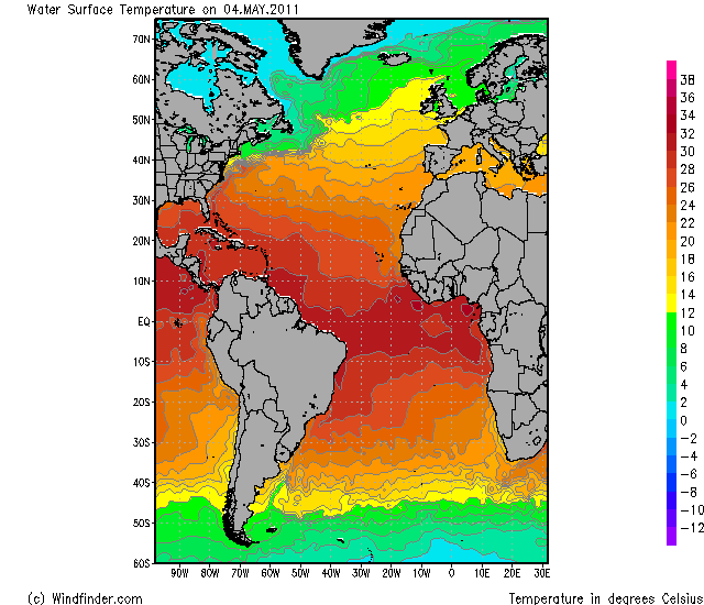
quote:Darwin sets its all-time 24-hour rainfall record
Darwin, Australia suffered its greatest 24-hour rainfall in its history on Wednesday, when a deluge of 13.4 inches (339.4 mm) hit the city when Tropical Cyclone Carlos formed virtually on top of city and remained nearly stationary. Over the past three days, Carlos has dumped a remarkable 25.37" (644.6 mm) of rain on the Darwin (population 125,000), capital of Australia's Northern Territory. Carlos has moved slowly inland today, and continues to dump rain on Darwin, but these rains will gradually subside over the next few days as the storm weakens and moves farther inland. Not surprisingly, the rains have triggered major flooding in the Darwin area. The heavy rains in Darwin are due to the very slow motion of the storm, which has been able to keep a significant portion of its circulation over the warm 30°C (86°F) waters off the coast. These water temperatures are near normal for this time of year. Australia's west coast is also watching Tropical Cyclone Dianne, which is expected to remain offshore as it moves southwards, parallel to the coast.
quote:Tropical Cyclone Bingiza makes a 2nd landfall in Madagascar
On Monday, Tropical Cyclone Bingiza roared ashore over Northern Madagascar as a dangerous Category 3 hurricane with 115 mph winds. The storm is being blamed for six deaths, has left 15,000 homeless, and has destroyed 8,500 buildings. After re-emerging over the waters of the Mozambique Channel between Africa and Madagascar on Tuesday, Bingiza re-intensified, and made a second landfall along the southwest coast of Madagascar early today as a tropical storm. Bingiza is expected to dissipate over Madagascar tomorrow, but not before dumping very heavy rains capable of causing additional flooding problems on Madagascar's deforested mountain slopes.
Bingiza is just the second tropical cyclone in the Southwest Indian Ocean (west of 90E) during the 2010 - 2011 season; this is an unusually low amount of activity for the basin. According to an email I received from Sebastien Langlade of the tropical cyclone forecasting office on La Reunion Island, January 2011 was the first January since accurate records began in 1998 that the Southwest Indian Ocean failed to record a single tropical storm. The only other storm in the basin so far this season has been Tropical Cyclone Abele (29 Nov - 4 Dec 2010), a Category 1 storm that stayed out to sea. Bingiza was the 4th major (Category 3 or stronger) tropical cyclone world-wide this year.
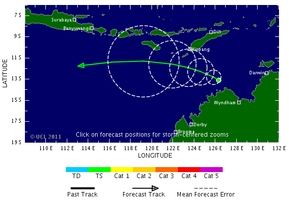
Als je naar de kaarten van gfs kijkt is Australie ook nog lang niet verlost van Carlos. Dit systeem trekt volgens dit model nog langs de noordkust en westkust.
kaartje van volgende week vrijdag. Carlos ligt dan aan de westkust
[ Bericht 4% gewijzigd door #ANONIEM op 17-02-2011 20:30:05 ]
kaartje van volgende week vrijdag. Carlos ligt dan aan de westkust
[ Bericht 4% gewijzigd door #ANONIEM op 17-02-2011 20:30:05 ]

quote:Carlos hits North Australia
River Daly peaked early in the day, flooding homes in the small town of Nauiyu, south of Darwin.
Local reports state animals in the area were snatched by crocodiles swimming in flood waters.
Authorities predict flood levels will not recede for at least four days. Makeshift shelters have been set up to house the community.
The Bureau of Meteorology has warned that Cyclone Carlos has now intensified into a Category One cyclone.

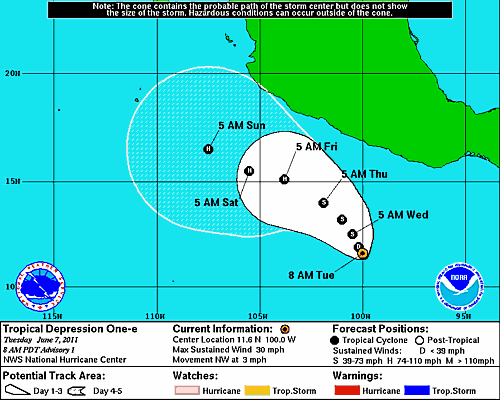
dan die japan nog raken?quote:
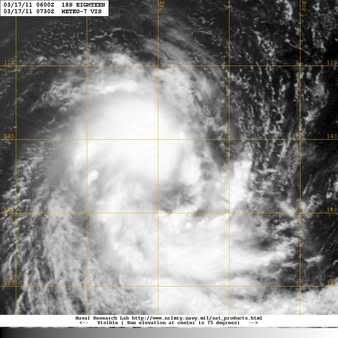
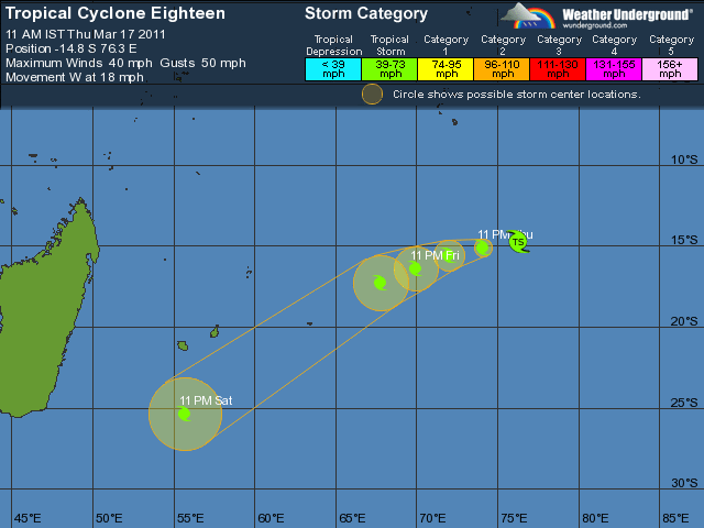
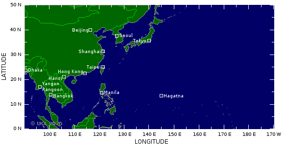
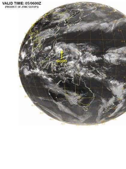
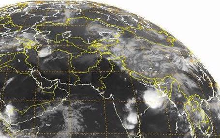
Nummer 18 in de Indische Oceaan.
[ afbeelding ]
Dan is het feest compleet daar
Inorbit: zeg dat dan typluie triangeljosti
Beauregard: Een beetje FOK!ker laat het brood door z'n moeder smeren.
Ecosia
ek's 'n flash drive, jy's 'n floppy
Beauregard: Een beetje FOK!ker laat het brood door z'n moeder smeren.
Ecosia
ek's 'n flash drive, jy's 'n floppy

Indische Oceaan ligt nog wel een eindje van Japan afquote:Op donderdag 17 maart 2011 09:36 schreef Jumparound het volgende:
[..]
dan die japan nog raken?
Dan is het feest compleet daar
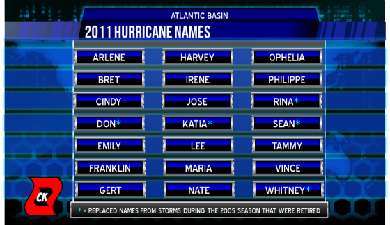
quote:Igor and Tomas retired Atlantic Huricane names
The hurricane committee of the World Meteorological Organization (WMO), which issues the list of potential names for tropical cyclones to be used every six years for both the Atlantic and eastern North Pacific basins, has decided to retire the Atlantic names Igor and Tomas.
Igor was a classic Cape Verde hurricane, reaching Category 4 strength with 155 miles per hour (250 kilometers per hour) winds on September 14, 2010, while located about 600 miles (965 kilometers) east of the northern Leeward Islands. The storm weakened to a Category 1 hurricane when it struck Bermuda on September 19.
Igor grew in size, with the area of tropical-storm-force winds becoming roughly 750 nautical miles (1389 kilometers) wide and made landfall on September 21 near Cape Race in Newfoundland. It was the most damaging hurricane on that island in 75 years and killed three people along its path. Damage in Newfoundland was placed at almost $200 million U.S. dollars.
Tomas, meanwhile, became a hurricane on October 30, shortly after striking Barbados. It strengthened to a Category 2 storm striking St. Vincent and St. Lucia, becoming the latest hurricane on record to strike the Windward Islands.
After weakening to a tropical depression over the central Caribbean Sea, Tomas regained Category 1 strength on November 5 and moved between Jamaica and the southwest peninsula of Haiti, through the Windward Passage. It weakened just below hurricane strength before reaching the Turks and Caicos Islands. Fourteen people are confirmed as dead, or missing, on St. Lucia. Total damage there is estimated to be around $500 million U.S. dollars. Heavy rains associated with Tomas triggered floods and landslides in Haiti, where meteorological services state that the death toll was 35.
If the WMO hurricane committee had not decided to scrap the names, Igor and Tomas in the Atlantic would have appeared again in 2016. Ian and Tobias will now take their place instead.
The only time that there is a change in the list of names is if a storm is so deadly or costly that the future use of its name on a different storm would be inappropriate for reasons of sensitivity. If that occurs, then at an annual meeting by the WMO committee, the offending name is stricken from the list and another name is selected to replace it.
The lists are re-cycled every six years, i.e., the 2010 list will be used again in 2016.
Japan Typhoon Season: Will Disaster Areas be Hit?
While typhoon season doesn't typically ramp up around Japan until late summer, the threat of a tropical system affecting the fragile nation as it slowly recovers from the devastating earthquake and tsunami is a major concern.
Japan is located in the most active tropical basin in the world. Historically, tropical systems passing within 100 miles (160 km) of Sendai, Japan, an area hit hard by the earthquake and tsunami, have been observed as early as mid-June.
However, the threat of a tropical system affecting Japan usually becomes greatest in August and September, when ocean waters that far north are warmest, according to AccuWeather.com Expert Tropical Forecaster Dan Kottlowski.
In the western North Pacific Basin as a whole, typhoons and tropical storms can develop any time of the year, but the period from July through October is normally the most active.
This graphic displays the total number of tropical storms, as well as the number of those forecast to develop into typhoons and super typhoons, expected in the western North Pacific Basin in 2011 compared to the average number per year.
This year in the western North Pacific Basin, the AccuWeather.com Hurricane Center is forecasting a fairly average typhoon season with a total of 27 tropical storms, 16 of which will become typhoons and 4 of which will strengthen into super typhoons.
The definitions of a typhoon, super typhoon, tropical storm and tropical depression are given at the bottom of this page.
Odds of a Typhoon Hitting Japan Disaster Areas this Year
There are several good things going for the disaster areas of Japan in terms of the risk of impact from a typhoon. However, despite these positives, tropical systems do affect northern Japan with some regularity, and flooding rain tends to be the biggest problem.
One of the positives is that only a small percentage of tropical systems that develop in the western North Pacific basin impact northeastern Japan.
Out of the estimated 1,757 tropical storms and typhoons that have formed in the western North Pacific basin between 1945 and 2008, approximately 40 (2 percent) have tracked within 100 miles (160 km) of Sendai. Storm tracks are based on the movement of the center or eye of the storm.
The other positive is that, historically, typhoons that do affect northern Japan tend to be in a weakening phase and do not pose a significant damaging wind threat.
This is due in part to the fact that these typhoons have often already made landfall either in southern Japan or somewhere else in the western North Pacific basin. It is also due in part to the fact that waters over which these systems track are cooler offshore of northern Japan.
Of the 40 tropical systems that passed within 100 miles of Sendai between 1945 and 2008, 16 were of typhoon strength at some point within 100 miles of Sendai. None of those typhoons were stronger than a Category 2 hurricane when they entered the 100-mile radius.
In fact, all but one of those 16 typhoons had a strength equivalent to a Category 1 hurricane during that time.
This image, courtesy of the U.S. National Oceanic and Atmospheric Administration's Historical Hurricane Tracks database, shows the tracks of tropical systems that moved within a 100-mile radius of Sendai, Japan, between 1945 and 2008. Light blue represents systems in the stage of a tropical depression, while green depicts a stage as a tropical storm. The other colors represent typhoons, with yellow being Category-1 hurricane strength, orange Category-2 hurricane strength and red Category-3 hurricane strength.
Because tropical systems that affect northern Japan tend to be weaker, the threat of wind damage is not a major concern. This is especially true for the earthquake and tsunami-ravaged areas of northeastern Japan, where the topography is such that these areas tend to be protected from damaging winds.
While the chance of any given typhoon, especially one stronger than a Category 2 hurricane, impacting Sendai (and other locations throughout the disaster area) is extremely small, tropical systems do affect that area with some regularity.
From 1945 to 2008, tropical systems have passed within 100 miles of Sendai 29 out of the 64 years, which is almost half the total number of years. The longest period of time that went by without a tropical system passing within 100 miles of Sendai was 4 years.
So even if the disaster areas of Japan were to escape impact from a tropical system this year, history would suggest that a system will affect these fragile areas within the next several years.
The last time a tropical system tracked significantly close to Sendai was in 2009. So if history repeats itself, one would expect another system to affect that area by 2013.
If or when that happens, flooding rain will be the biggest threat.
What is a Typhoon?
A typhoon is essentially the same thing as a hurricane. Both terms are regionally specific names for a strong tropical cyclone with sustained winds of at least 74 mph (119 kph).
A super typhoon, as defined by the U.S. Joint Typhoon Warning Center, is a typhoon with maximum sustained winds of at least 150 mph (241 kph), which would be equivalent to strong Category 4 or a Category 5 hurricane.
The term tropical storm is a name for a weaker tropical cyclone with sustained winds between 39 and 73 mph (62-117 kph). A tropical depression is a tropical cyclone with sustained winds less than 39 mph.
Accuweather
While typhoon season doesn't typically ramp up around Japan until late summer, the threat of a tropical system affecting the fragile nation as it slowly recovers from the devastating earthquake and tsunami is a major concern.
Japan is located in the most active tropical basin in the world. Historically, tropical systems passing within 100 miles (160 km) of Sendai, Japan, an area hit hard by the earthquake and tsunami, have been observed as early as mid-June.
However, the threat of a tropical system affecting Japan usually becomes greatest in August and September, when ocean waters that far north are warmest, according to AccuWeather.com Expert Tropical Forecaster Dan Kottlowski.
In the western North Pacific Basin as a whole, typhoons and tropical storms can develop any time of the year, but the period from July through October is normally the most active.

This graphic displays the total number of tropical storms, as well as the number of those forecast to develop into typhoons and super typhoons, expected in the western North Pacific Basin in 2011 compared to the average number per year.
This year in the western North Pacific Basin, the AccuWeather.com Hurricane Center is forecasting a fairly average typhoon season with a total of 27 tropical storms, 16 of which will become typhoons and 4 of which will strengthen into super typhoons.
The definitions of a typhoon, super typhoon, tropical storm and tropical depression are given at the bottom of this page.
Odds of a Typhoon Hitting Japan Disaster Areas this Year
There are several good things going for the disaster areas of Japan in terms of the risk of impact from a typhoon. However, despite these positives, tropical systems do affect northern Japan with some regularity, and flooding rain tends to be the biggest problem.
One of the positives is that only a small percentage of tropical systems that develop in the western North Pacific basin impact northeastern Japan.
Out of the estimated 1,757 tropical storms and typhoons that have formed in the western North Pacific basin between 1945 and 2008, approximately 40 (2 percent) have tracked within 100 miles (160 km) of Sendai. Storm tracks are based on the movement of the center or eye of the storm.
The other positive is that, historically, typhoons that do affect northern Japan tend to be in a weakening phase and do not pose a significant damaging wind threat.
This is due in part to the fact that these typhoons have often already made landfall either in southern Japan or somewhere else in the western North Pacific basin. It is also due in part to the fact that waters over which these systems track are cooler offshore of northern Japan.
Of the 40 tropical systems that passed within 100 miles of Sendai between 1945 and 2008, 16 were of typhoon strength at some point within 100 miles of Sendai. None of those typhoons were stronger than a Category 2 hurricane when they entered the 100-mile radius.
In fact, all but one of those 16 typhoons had a strength equivalent to a Category 1 hurricane during that time.

This image, courtesy of the U.S. National Oceanic and Atmospheric Administration's Historical Hurricane Tracks database, shows the tracks of tropical systems that moved within a 100-mile radius of Sendai, Japan, between 1945 and 2008. Light blue represents systems in the stage of a tropical depression, while green depicts a stage as a tropical storm. The other colors represent typhoons, with yellow being Category-1 hurricane strength, orange Category-2 hurricane strength and red Category-3 hurricane strength.
Because tropical systems that affect northern Japan tend to be weaker, the threat of wind damage is not a major concern. This is especially true for the earthquake and tsunami-ravaged areas of northeastern Japan, where the topography is such that these areas tend to be protected from damaging winds.
While the chance of any given typhoon, especially one stronger than a Category 2 hurricane, impacting Sendai (and other locations throughout the disaster area) is extremely small, tropical systems do affect that area with some regularity.
From 1945 to 2008, tropical systems have passed within 100 miles of Sendai 29 out of the 64 years, which is almost half the total number of years. The longest period of time that went by without a tropical system passing within 100 miles of Sendai was 4 years.
So even if the disaster areas of Japan were to escape impact from a tropical system this year, history would suggest that a system will affect these fragile areas within the next several years.
The last time a tropical system tracked significantly close to Sendai was in 2009. So if history repeats itself, one would expect another system to affect that area by 2013.
If or when that happens, flooding rain will be the biggest threat.
What is a Typhoon?
A typhoon is essentially the same thing as a hurricane. Both terms are regionally specific names for a strong tropical cyclone with sustained winds of at least 74 mph (119 kph).
A super typhoon, as defined by the U.S. Joint Typhoon Warning Center, is a typhoon with maximum sustained winds of at least 150 mph (241 kph), which would be equivalent to strong Category 4 or a Category 5 hurricane.
The term tropical storm is a name for a weaker tropical cyclone with sustained winds between 39 and 73 mph (62-117 kph). A tropical depression is a tropical cyclone with sustained winds less than 39 mph.
Accuweather

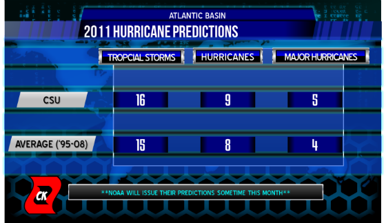
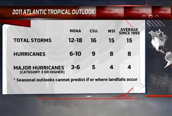
2011 Atlantic Hurricane Season will be Active, Have more US Landfalls
AccuWeather.com Hurricane Center meteorologists, led by Meteorologist and Hurricane Forecaster Paul Pastelok, are predicting an active season for 2011 with more impact on the U.S. coastline than last year.
The team is forecasting a total of 15 named tropical storms, eight of which will attain hurricane status and three of which will attain major hurricane status (Category 3 or higher).
In a normal year, there are 10 tropical storms, six of which become hurricanes and two of which become major hurricanes, or attain winds that exceed 110 mph.
2010's historic season had a total of 19 named storms and ranks as the third most active season on record, but there was little impact on the United States coastline. Twelve of these storms became hurricanes, five of which were major hurricanes. Two names from the 2010 season were retired on March 16.
"It looks like we're going to have more impact on the mainland of the U.S. coming up this year compared to last year," Pastelok said. "We had a lot of storms last year, but not a lot of impact [on the U.S.]."
In order to project the number of storms and impacts, the team looks at past years that have similar weather variables and patterns that closely resemble the most recent fall, winter and early spring months.
Factors for this Season
There are a number of physical drivers that have the team concerned for this upcoming hurricane season. These include:
--The orientation and position of the Azores and Bermuda high-pressure areas in the Atlantic
The Azores high is one of the bigger influences on the movement of tropical cyclones. High pressure systems alter the direction of a storm by steering the storm, a low pressure system, around it. This is one way forecasters can predict the track of a hurricane.
"The forecast position and strength of the Azores or Bermuda high is always a challenging forecast," Pastelok said. "An unexpected change could greatly alter where both early season and mid season storms track."
AccuWeather.com Expert Tropical Forecaster Dan Kottlowski added, "We do see some changes in the overall pattern across the Atlantic."
Kottlowski continued, "The water temps are not nearly as warm as they were last year, and also the upper air pattern looks slightly different... than last year, so that could have an impact as to where that subtropical high, that big high pressure area that helps guide tropical storms, sets up."
"It may weaken or actually reposition itself a little bit to the northeast as we get later in the season, which would allow more of a storm track closer to Florida and also up the East Coast," Kottlowski concluded.
--The future state of the ongoing La Niña
La Niña is a phenomenon that occurs when the surface waters in the central and eastern equatorial Pacific are colder than normal. La Niña results in low wind shear, especially in the main tropical development area in the Atlantic. Shear refers to strong winds that are high in the atmosphere. Wind shear is a "hurricane killer," in that it can hinder storm development as well as break up existing storms.
"Currently, right now we still are in a La Niña scenario, but it is starting to weaken," Pastelok said. "The signal is starting to show some signs of going neutral. That could have an impact on the westerly wind component down in the tropical Atlantic as well as the Caribbean. Stronger westerlies would prohibit major storms or a lot of storms, so it is a critical factor."
--The frequency and amount of dust that accompanies disturbances moving off the African coast
The presence of dust indicates dry air, which can hinder tropical development in the eastern Atlantic.
"Current projections on the weather pattern over Africa for this coming tropical season suggests there will be episodes of dust affecting development, but no more than normal," Pastelok said.
--A phenomenon known as Atlantic Multidecadal Oscillation (AMO)
AMO refers to the sea surface temperature in the northern Atlantic, and the temperature fluctuates from colder than average to warmer than average every few decades. Currently, the sea surface temperature is in the warm phase, and warm water is "hurricane fuel," in that it supports the development of tropical systems.
"We continue to observe the positive phase of the Atlantic Multidecadal Oscillation," said Paul Pastelok. "This will help to maintain warmer-than-normal water temperatures across most of the Atlantic Basin."
This Season's Concern Areas
As with most Atlantic hurricane seasons, the areas where storms are most likely to make landfall shift as the season progresses.
This year, the early season threat area will be the western Gulf of Mexico and the southern portion of the Caribbean. Within this zone, the higher concern for landfalls will be along the Texas and Louisiana coastlines.
As for the mid-to-late season zones, the eastern Gulf and Caribbean will be the focus. The higher concern areas will be the Florida Peninsula to the Carolinas.
"What we see is there is a clustering of storm impacts over the southeastern US, and that's the reason why we earmarked this as a concern area," said Kottlowski.
Another mid-to-late season concern for landfalls will be northern New England and the Canadian Maritimes.
"We feel that this season, there will be a higher potential for impacts across the southern part of the Basin into the Gulf of Mexico during the first part of the season," Pastelok stated. "This higher potential for impacts shift farther north into the southeast U.S. during the latter half of the season."
Hurricane season officially begins June 1 and ends Nov. 30.
For all the latest tropical information, be sure to check the AccuWeather.com Hurricane Center for the most up-to-date videos, information and storm tracks.

AccuWeather.com Hurricane Center meteorologists, led by Meteorologist and Hurricane Forecaster Paul Pastelok, are predicting an active season for 2011 with more impact on the U.S. coastline than last year.
The team is forecasting a total of 15 named tropical storms, eight of which will attain hurricane status and three of which will attain major hurricane status (Category 3 or higher).
In a normal year, there are 10 tropical storms, six of which become hurricanes and two of which become major hurricanes, or attain winds that exceed 110 mph.
2010's historic season had a total of 19 named storms and ranks as the third most active season on record, but there was little impact on the United States coastline. Twelve of these storms became hurricanes, five of which were major hurricanes. Two names from the 2010 season were retired on March 16.
"It looks like we're going to have more impact on the mainland of the U.S. coming up this year compared to last year," Pastelok said. "We had a lot of storms last year, but not a lot of impact [on the U.S.]."
In order to project the number of storms and impacts, the team looks at past years that have similar weather variables and patterns that closely resemble the most recent fall, winter and early spring months.
Factors for this Season
There are a number of physical drivers that have the team concerned for this upcoming hurricane season. These include:
--The orientation and position of the Azores and Bermuda high-pressure areas in the Atlantic
The Azores high is one of the bigger influences on the movement of tropical cyclones. High pressure systems alter the direction of a storm by steering the storm, a low pressure system, around it. This is one way forecasters can predict the track of a hurricane.
"The forecast position and strength of the Azores or Bermuda high is always a challenging forecast," Pastelok said. "An unexpected change could greatly alter where both early season and mid season storms track."
AccuWeather.com Expert Tropical Forecaster Dan Kottlowski added, "We do see some changes in the overall pattern across the Atlantic."
Kottlowski continued, "The water temps are not nearly as warm as they were last year, and also the upper air pattern looks slightly different... than last year, so that could have an impact as to where that subtropical high, that big high pressure area that helps guide tropical storms, sets up."
"It may weaken or actually reposition itself a little bit to the northeast as we get later in the season, which would allow more of a storm track closer to Florida and also up the East Coast," Kottlowski concluded.
--The future state of the ongoing La Niña
La Niña is a phenomenon that occurs when the surface waters in the central and eastern equatorial Pacific are colder than normal. La Niña results in low wind shear, especially in the main tropical development area in the Atlantic. Shear refers to strong winds that are high in the atmosphere. Wind shear is a "hurricane killer," in that it can hinder storm development as well as break up existing storms.
"Currently, right now we still are in a La Niña scenario, but it is starting to weaken," Pastelok said. "The signal is starting to show some signs of going neutral. That could have an impact on the westerly wind component down in the tropical Atlantic as well as the Caribbean. Stronger westerlies would prohibit major storms or a lot of storms, so it is a critical factor."
--The frequency and amount of dust that accompanies disturbances moving off the African coast
The presence of dust indicates dry air, which can hinder tropical development in the eastern Atlantic.
"Current projections on the weather pattern over Africa for this coming tropical season suggests there will be episodes of dust affecting development, but no more than normal," Pastelok said.
--A phenomenon known as Atlantic Multidecadal Oscillation (AMO)
AMO refers to the sea surface temperature in the northern Atlantic, and the temperature fluctuates from colder than average to warmer than average every few decades. Currently, the sea surface temperature is in the warm phase, and warm water is "hurricane fuel," in that it supports the development of tropical systems.
"We continue to observe the positive phase of the Atlantic Multidecadal Oscillation," said Paul Pastelok. "This will help to maintain warmer-than-normal water temperatures across most of the Atlantic Basin."

This Season's Concern Areas
As with most Atlantic hurricane seasons, the areas where storms are most likely to make landfall shift as the season progresses.
This year, the early season threat area will be the western Gulf of Mexico and the southern portion of the Caribbean. Within this zone, the higher concern for landfalls will be along the Texas and Louisiana coastlines.
As for the mid-to-late season zones, the eastern Gulf and Caribbean will be the focus. The higher concern areas will be the Florida Peninsula to the Carolinas.
"What we see is there is a clustering of storm impacts over the southeastern US, and that's the reason why we earmarked this as a concern area," said Kottlowski.
Another mid-to-late season concern for landfalls will be northern New England and the Canadian Maritimes.
"We feel that this season, there will be a higher potential for impacts across the southern part of the Basin into the Gulf of Mexico during the first part of the season," Pastelok stated. "This higher potential for impacts shift farther north into the southeast U.S. during the latter half of the season."
Hurricane season officially begins June 1 and ends Nov. 30.
For all the latest tropical information, be sure to check the AccuWeather.com Hurricane Center for the most up-to-date videos, information and storm tracks.


Doden door tropische stormen in Bangladesh
(Novum/AP) - Noodweer heeft in Bangladesh aan zeker dertien mensen het leven gekost. Daarnaast hebben rond de honderd mensen verwondingen opgelopen toen zes districten in het noorden van het land maandagavond door tropische stormen geteisterd werden.
In het getroffen gebied werden honderden onderkomens door de krachtige slagregens verwoest. Enkele duizenden mensen zijn dakloos geraakt. Dit hebben de Bengalese media dinsdag gemeld.
Nieuws.nl
Zo Het VWK en Paulus Pietsma komen er nu pas mee terwijl het artikel al een kleine vier maanden oud is
Hurricane Season 2011
Hurricane Season 2011
Weer of geen weer, altijd actueel www.onweer-online.nl

Nee dus 
quote:An area of thunderstorms about 1,200 miles from Southwest Florida — which has the official name of Invest 91— is highly unlikely to develop into any kind of named storm.
So says Jim Farrell, WINK News chief meteorologist. “Could even be gone by tomorrow,” Farrell said. “I don’t anticipate much happening.”
If history is any guide, the weather system will most certainly die out. Since 1851 there has been only one named storm in April, Tropical Storm Ana in 2003.
The storm is in an area of high wind shear.
“A very hostile upper air environment,” Farrell said.
At higher altitudes, winds are racing west to east, a strong inhibitor to further development.
“This is very typical for this time of the year,” Farrell said.
The storm is about 460 miles northeast of Puerto Rico in the Atlantic Ocean.
The National Hurricane Center in Miami gives the storm only a 20 percent chance for further intensification. The NHC reported that ships in the storm’s area reported gale-force winds near the center of the disturbance. That would put wind gusts in the 45-to-50 mile-per-hour range.
quote:A tropical disturbance (91L) near 24N, 63W, midway between the Virgin Islands and Bermuda, is moving north-northwest at about 8 mph. The system's heavy thunderstorm activity has increased since yesterday, but 91L has an elongated and poorly-organized circulation, thanks to a hefty 80 knots of wind shear. The storm is over waters of 25°C, and these waters will cool to 24°C by Friday as the storm continues to the north-northwest. Before 91L reaches Bermuda, steering currents will reverse and force 91L to the south-southwest on Saturday, into a region of higher wind shear. The latest SHIPS model forecast predicts wind shear will drop to 50 knots over 91L by Friday, then increase again to 70 knots by Sunday. The high shear and relatively cool water temperatures will make it difficult for 91L to organize into a subtropical depression. I give 91L a 10% of becoming a subtropical depression. Climatology argues against 91L becoming the first named storm of the year; there has only been once named April storm in the Atlantic since 1851, Tropical Storm Ana of 2003. The formation of a tropical disturbance at this location this time of year is unusual, but is not necessarily a harbinger of a active season ahead.

Hmm, heeft iemand een idee wanneer ze de eerste (echte) orkaan verwachten? kan er niet veel over vinden (ja, ik weet het, officieel begint het orkaan seizoen op 1 juni, maar wanneer verwachten ze de eerste orkaan?)
Dat is moeilijk te zeggen. Het seizoen kan vroeg beginnen, maar kan ook net als vorig jaar pas laat op gang komen.quote:Op dinsdag 3 mei 2011 14:06 schreef Floxxx het volgende:
Hmm, heeft iemand een idee wanneer ze de eerste (echte) orkaan verwachten? kan er niet veel over vinden (ja, ik weet het, officieel begint het orkaan seizoen op 1 juni, maar wanneer verwachten ze de eerste orkaan?)
Aan de zeewatertemperatuur zal het niet liggen...
Er van uit gaande dat je orkaan bedoeld (je schrijft ook (echte) erbij) en dus een Categorie 1 orkaan en geen tropische storm en/of depressies die ook namen krijgen dan is het volgens mij in de laatste dertig jaar niet voorgekomen dat er een Categorie 1 orkaan ontstond voor één juni. Misschien wel langer.quote:
Hmm, heeft iemand een idee wanneer ze de eerste (echte) orkaan verwachten? kan er niet veel over vinden (ja, ik weet het, officieel begint het orkaan seizoen op 1 juni, maar wanneer verwachten ze de eerste orkaan?)
Ik zou op inzetten op de laatste week van juni voor de eerste Cat.1 Orkaan er is.
Ik doelde inderdaad op minimaal Cat 1, tropische stormen zijn niet zo interessantquote:
[..]
Er van uit gaande dat je orkaan bedoeld (je schrijft ook (echte) erbij) en dus een Categorie 1 orkaan en geen tropische storm en/of depressies die ook namen krijgen dan is het volgens mij in de laatste dertig jaar niet voorgekomen dat er een Categorie 1 orkaan ontstond voor één juni. Misschien wel langer.
Ik zou op inzetten op de laatste week van juni voor de eerste Cat.1 Orkaan er is.
Ik woon namelijk in Florida en probeer er meestal wel een oogje op te houden, maar heb nooit echt nagekeken wanneer het nou echt begint :p
Laatste jaren is florida er redelijk ongeschonden vanaf gekomen denk ik?
wat dat betreft wordt het wel weer eens tijd
wat dat betreft wordt het wel weer eens tijd
Laatste zware orkaanseizoen voor Florida was in 2005 geloof ik, ik hoop dat het nog even uitblijft, maar ze verwachten een zwaar seizoen dit jaar, dus ben bang dat dat er niet in zit...quote:Op dinsdag 3 mei 2011 19:20 schreef Frutsel het volgende:
Laatste jaren is florida er redelijk ongeschonden vanaf gekomen denk ik?
wat dat betreft wordt het wel weer eens tijd
Dachten ze vorig jaar ook... toen werd het nada, noppes enzoquote:
[..]
Laatste zware orkaanseizoen voor Florida was in 2005 geloof ik, ik hoop dat het nog even uitblijft, maar ze verwachten een zwaar seizoen dit jaar, dus ben bang dat dat er niet in zit...
Let's hope soquote:
[..]
Dachten ze vorig jaar ook... toen werd het nada, noppes enzo

Een tropische storm kan voor flink wat ellende zorgen.quote:
[..]
Ik doelde inderdaad op minimaal Cat 1, tropische stormen zijn niet zo interessant
Ik woon namelijk in Florida en probeer er meestal wel een oogje op te houden, maar heb nooit echt nagekeken wanneer het nou echt begint :p
Goed voorbeeld zijn de overstromingen in Australie begin dit jaar. Die werden veroorzaakt door een Tropische Storm...
Overstromingen Australie: Ergste in honderd jaar
Zo dan. Da's een nog grotere resevoir aan 30+ water dan in 2010. En uiteindelijk is dat toch de bak met energie die de orkanen moeten ledigen...quote:Op dinsdag 3 mei 2011 14:49 schreef aloa het volgende:
[..]
Dat is moeilijk te zeggen. Het seizoen kan vroeg beginnen, maar kan ook net als vorig jaar pas laat op gang komen.
Aan de zeewatertemperatuur zal het niet liggen...
[ afbeelding ]
Stiekem hoop ik op nog een Thomas die over Barbados heen scheert, en dat de instrumenten die we daar hebben staan het dan wel uithouden
Yasi, een monsterorkaan, kwam er toch ook nog overheen?quote:Op dinsdag 3 mei 2011 19:57 schreef aloa het volgende:
[..]
Een tropische storm kan voor flink wat ellende zorgen.
Goed voorbeeld zijn de overstromingen in Australie begin dit jaar. Die werden veroorzaakt door een Tropische Storm...
Overstromingen Australie: Ergste in honderd jaar
Die kwam inderdaad ook nog een aantal weken later.quote:
[..]
Yasi, een monsterorkaan, kwam er toch ook nog overheen?
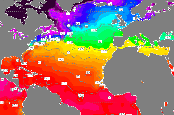
En het is nog maar mei. Water is volgens mij vroeg op temperatuur.quote:
[..]
Zo dan. Da's een nog grotere resevoir aan 30+ water dan in 2010. En uiteindelijk is dat toch de bak met energie die de orkanen moeten ledigen...
Stiekem hoop ik op nog een Thomas die over Barbados heen scheert, en dat de instrumenten die we daar hebben staan het dan wel uithouden
Een collega voer afgelopen lente (precies rond dit moment) over de evenaar/langs de kaap verden, en toen was het water daar net boven de 30, dat was bijzonder. Toen ik hetzelfde tripje afgelopen oktober uitvoerde, was er eentje die wedde dat we de 30 wel zouden aantikken. Die heeft dus een ontbijt in volle duikuitrusting gedaan.quote:
[..]
En het is nog maar mei. Water is volgens mij vroeg op temperatuur.
[ afbeelding ]
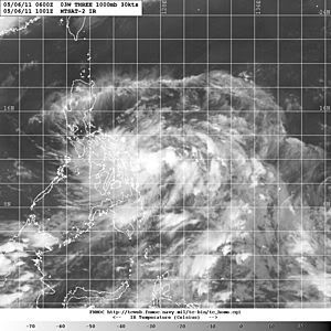
Tropical Depression Develops, Threatens Philippines
An early-season tropical depression has formed east of the Philippines. Very heavy rain has begun to fall over central and northern areas of the nation and will continue to do so over the next several days.
Nearly 10 inches (250 mm) of rain has already fallen at Catarman as the center of the tropical depression remained just off the east coast.
The depression was moving slowly to the northwest at around 5 mph. Some slow strengthening into a tropical storm is likely over the next day or two before the center of the storm passes over northern Luzon Island in the northern Philippines early next week.
The main impact from this system will be localized flooding and strong winds, especially across eastern Luzon and eastern Visayas.
Daily rainfall totals can exceed 5 inches (125 mm) in many areas of central and northern Philippines, and could exceed 10 inches (250 mm) in a few locations. Widespread flooding will result, and could produce deadly mudslides.
Wind gusts can exceed 60 mph (95 kph) at the time of landfall over eastern Luzon Island. Landfall is expected late morning or early in the afternoon Monday, local time.
Accuweather
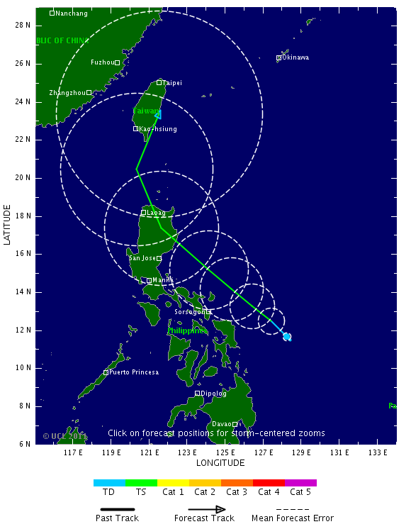
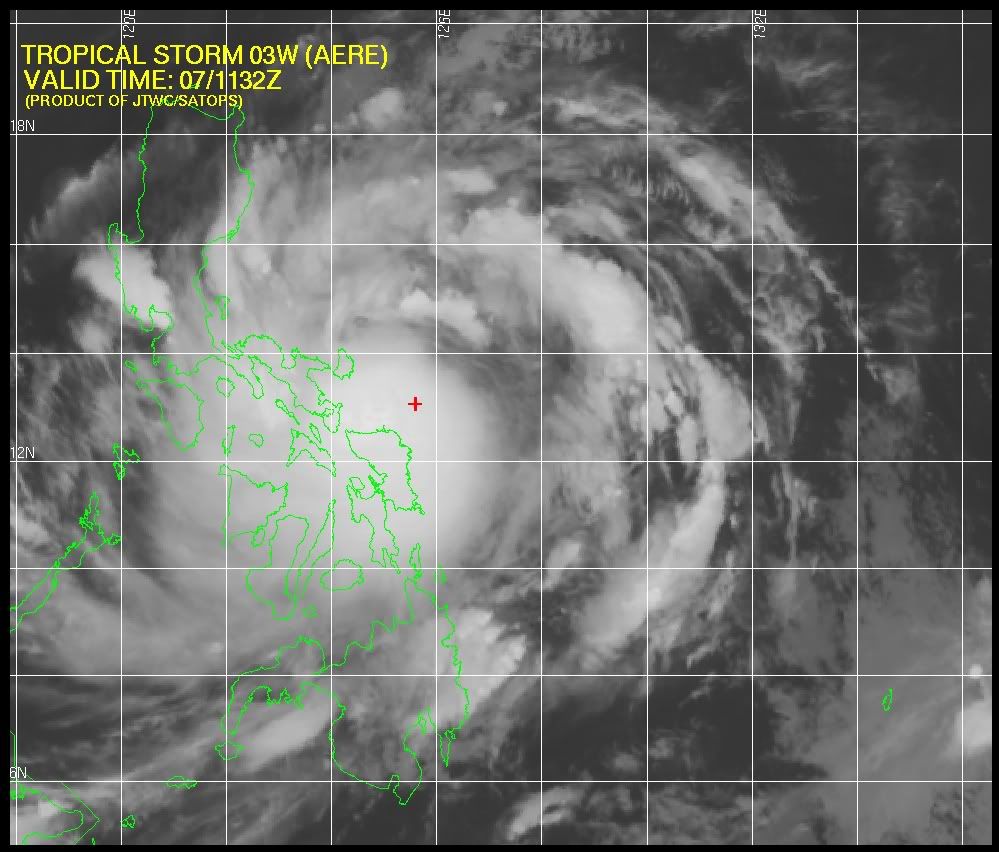
Tropische storm eist minstens negen levens in Filipijnen
De tropische storm Aere heeft vandaag zeker negen levens geëist in het oosten van de Filipijnen. Vanwege de zware regenval en landverschuivingen zijn meer dan honderdduizend mensen geëvacueerd. Dat hebben de lokale autoriteiten bekendgemaakt.
Aere is de eerste grote storm dit jaar die het Zuidoost-Aziatische land aandoet. De storm trekt de komende uren naar Luzon, het grote eiland in het noorden. (anp/adv)
hln
Meer doden in Filipijnen door noodweer
(Novum/AP) - MANILLA - De tropische storm Aere heeft in het noordoosten van de Filipijnen aan zeker elf mensen, onder wie een baby, het leven gekost. Meer dan honderdduizend mensen zijn op de vlucht geslagen uit angst voor aardverschuivingen.
De storm kwam zondag in de provincie Catanduanes aan land en bereikte windsnelheden tot 85 kilometer per uur. Op sommige plekken werden windstoten van meer dan 100 kilometer per uur gemeten.
Het noodweer veroorzaakte aardverschuivingen en overstromingen en zorgde voor stroomstoringen in verschillende steden. Bijna vijfduizend forenzen strandden in havens, omdat veerboten niet uitvoeren. Een groot aantal wegen was gesloten, omdat ze waren overstroomd of omdat er aardverschuivingen dreigden. Tevens werd een aantal binnenlandse vluchten geannuleerd.
De storm verplaatst zich naar verwachting richting het noordwesten om de archipel vervolgens te verlaten, aldus de meteorologische dienst.
nieuws.nl
Dodental noodweer Filipijnen loopt op
MANILA (ANP/EFE) – Het dodental als gevolg van de tropische storm Aere op de Filipijnen is opgelopen tot dertien. Onder de slachtoffers zijn drie kinderen. Twee mensen worden vermist. Dat hebben de autoriteiten in het Aziatische land maandag gemeld. Eerder was melding gemaakt van negen doden.
De storm heeft vooral het oosten van de eilandengroep zwaar getroffen. Meer dan honderdduizend mensen daar zijn uit hun huizen verdreven door overstromingen en aardverschuivingen.
Het orkaanseizoen in Zuidoost-Azië begint doorgaans in mei of juni en houdt aan tot en met oktober of november. Gemiddeld krijgen de Filipijnen in die periode te maken met vijftien tot twintig gevaarlijke tyfonen.
bron
This graphic displays the total number of tropical storms, as well as the number of those forecast to develop into typhoons and super typhoons, expected in the western North Pacific Basin in 2011 compared to the average number per year.

Tropische storm eist 24 doden op Filipijnen
De tropische storm Aere heeft 24 levens geëist op de Filipijnen. Dat hebben de autoriteiten laten weten.
De storm geselde de Filipijnen zondag en ging gepaard met stortregens.
Op het grote eiland Luzon moesten bijna 70.000 mensen hun huizen verlaten. Er is zware schade aan de landbouw: een eerste schatting spreekt van 2,7 miljoen dollar, of zo'n 1,87 miljoen euro.
De Filipijnen krijgen elk jaar een twintigtal tyfoons te verwerken. Sommigen richten veel schade aan en zorgen ook voor doden. (belga/vsv)
hln
[ Bericht 1% gewijzigd door #ANONIEM op 11-05-2011 09:20:54 ]
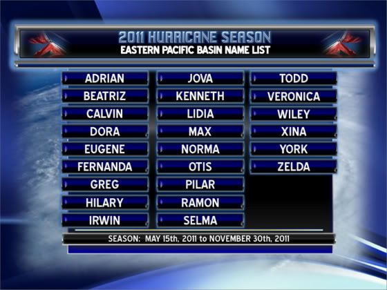
Zondag 15 mei begint het orkaan seizoen in de Eastern Pacific. Er worden meer stormen met een naam verwacht dan vorig jaar. Vorig jaar waren er maar 7 stormen die een naam kregen.
Dit jaar worden er 15 stormen verwacht waarvan er 9 een naam zullen krijgen. 4 van deze stormen bereiken volgens de verwachting de major hurricane status. (Categorie 3 of meer)
Dit jaar worden er 15 stormen verwacht waarvan er 9 een naam zullen krijgen. 4 van deze stormen bereiken volgens de verwachting de major hurricane status. (Categorie 3 of meer)
quote:Hurricane Season Starts Sunday in Eastern Pacific
"Fifteen named storms would more than double the total from last year"
Sunday marks the official start of the 2011 hurricane season in the Eastern Pacific, a season which is expected to exceed the amount of named tropical systems from last year by twofold.
AccuWeather.com meteorologists are predicting an average number of tropical systems to develop in the Eastern Pacific this year.
The basin averages 15 tropical storms each season. Out of those, nine become hurricanes, with four reaching major hurricane status.
Fifteen named storms would more than double the total from last year. Only seven named storms formed in the Eastern Pacific in 2010, with three reaching hurricane status.
"Last year was... about as quiet as it can get," stated AccuWeather.com Western Expert Meteorologist Ken Clark.
"A strengthening La Niña can be partially attributed to the lack of tropical storms [last year]," reported AccuWeather.com Staff Writer Gina Cherundolo in her recap of the 2010 Eastern Pacific hurricane season.
A weakening La Niña, on the other hand, will bring the basin's hurricane season back to normal this year.
"The water [in the Eastern Pacific] will steadily warm, which will lead to lower pressure," stated AccuWeather.com Expert Senior Meteorologist Bob Smerbeck. Lower pressure will then open the door for the development of tropical systems.
"Since the pressure will remain slightly above average early in the season, we are not expecting a quick start," Smerbeck added.
There are clusters of thunderstorms currently streaming across the Eastern Pacific, but none show signs of future development.
The first tropical storm to develop in the Eastern Pacific this year will acquire the name "Adrian."
Hurricane season in the Eastern Pacific will run until November 30, which coincides with the end of hurricane season in the Atlantic Basin.
The 2011 Atlantic Basin hurricane season does not officially begin until June 1. The earlier start time in the Eastern Pacific reflects how this basin typically turns active faster than the Atlantic.
On average, June 9 is when the first tropical storm is named in the Eastern Pacific. In the Atlantic, that date is July 10.
Hurricanes typically develop much quicker in the Eastern Pacific than the Atlantic. The average first date for a hurricane to form in the Eastern Pacific is June 24, but not until August 14 in the Atlantic.
Despite the Eastern Pacific being rather active, the majority of tropical storms and hurricanes never threaten land. A typical Eastern Pacific tropical system will head westward into open and progressively cooler ocean waters, dissipating in the process.
Occasionally, tropical storms and hurricanes will target Mexico and parts of Central America. Though less frequently, some tropical systems have threatened Hawaii. Hurricane Felicia approached Hawaii in 2009, but weakened below tropical depression status prior to reaching the islands.
Since records began, the cool water that lies offshore of California has protected the state from direct hits by tropical storms and hurricanes in every year but one. In September 1939, an unnamed tropical storm pressed onshore at Long Beach, California with maximum sustained winds of 50 mph.
Two other storms have moved into Arizona at tropical storm strength. The first was once-Hurricane Joanne in October 1972, followed by once-Hurricane Kathleen in September 1976.
No systems have reached the Southwest at hurricane strength.
Dodental op de Filipijnen is opgelopen tot 31.
quote:Tropische storm Aere eist 31 levens op Filipijnen
De tropische storm Aere heeft op de Filipijnen al 31 mensen het leven gekost, zo hebben de autoriteiten laten weten.
De storm geselde de Filipijnen afgelopen zondag en ging gepaard met stortregens. Op het grote eiland Luzon moesten bijna 70.000 mensen hun huizen verlaten.
De Filipijnen krijgen elk jaar een twintigtal taifoens te verwerken. Sommige richten veel schade aan en zorgen ook voor doden.
hln
Ik denk dat we tot Selma komen 
Doe mee met het voorspellen van het weer!
Weekvoorspelling | Week 12 (invullen tot 16-03 - 11:59)
Maandvoorspelling Maart (Inzendingen gesloten)
Jaarvoorspelling 2025 / 2026
Weekvoorspelling | Week 12 (invullen tot 16-03 - 11:59)
Maandvoorspelling Maart (Inzendingen gesloten)
Jaarvoorspelling 2025 / 2026
ik dacht meer aan die ene, met MAXimum windspeeds up to 300km/uquote:
GREG en IRWIN klinken echt als cat.5 orkanen.
wundergroundquote:First tropical wave of the year over the Atlantic
The first tropical wave of 2011 is now over the tropical Atlantic near 6°N 46°W, according to the latest Atlantic Tropical Weather Discussion. The wave will bring heavy rain to the northeast coast of South America over the next two days, but is too far south to be a threat to develop into a tropical depression. The Atlantic hurricane season is just two weeks away, and the Eastern Pacific hurricane season began yesterday. So far, the models are not predicting any tropical storm development in the East Pacific or Atlantic over the next six days.

quote:Tropical Storm Aere formed in early May 2011, just east of the Philippines. Channel News Asia and Unisys Weather reported that the storm made landfall on May 8. By May 13, the Philippine government reported that the storm’s death toll in that nation stood at 31. Besides strong winds, the storm brought torrential rains that caused flash floods and landslides.
A color-coded image was created using data from NASA's Tropical Rainfall Measuring Mission (TRMM) satellite by Jesse Allen at NASA's Goddard Space Flight Center, Greenbelt, Md. The image shows estimated rainfall amounts from May 5 to 12, 2011. In the image, the lowest rainfall amounts (less than 75 millimeters, or 3 inches) appear in pale green, and the heaviest amounts (more than 600 millimeters, or 24 inches) appear in dark blue. The heaviest rainfall forms a kind of bull’s eye over the easternmost islands, southeast of Manila. Rainfall amounts fall farther away from this area, but rain still affects a broad swath across the central Philippines.
Over the course of its existence, Tropical Storm Aere traveled in a large arc. The storm passed over the northern Philippines, and passed east of Taiwan before curving back toward the northeast. Aere dissipated south of Japan.
Tropical storms and damaging rains frequently affect the Philippines, Typhoon Megi, Tropical Storm Conson, and Tropical Storm Ketsana being just a few of the storms to cause widespread damage. Torrential rains can also affect the islands even without the influence of named storms, such as heavy rains in January 2011.
PSU Atlantic hurricane season forecast: 16 named storms
Expect a busy Atlantic hurricane season this year, with sixteen named storms, say Pennsylvania State University (PSU) hurricane scientists Michael Mann and Michael Kozar. Their annual Atlantic hurricane season forecast issued on May 16 calls for 12 - 20 named storms this season, which starts June 1 and runs until November 30. An average season has 10 - 11 named storms. Their prediction was made using statistics of how past hurricane seasons have behaved in response to sea surface temperatures (SSTs), the El Niño/La Niña oscillation, the North Atlantic Oscillation (NAO), and other factors. This year's forecast is primarily based on three factors:
1) The current above-average sea surface temperatures in the Atlantic Main Development Region (MDR) for hurricanes, from Central America to the coast of Africa between 10°C and 20°C North latitude, will continue into the main part of hurricane season;
2) The fading La Niña event in the Eastern Pacific Ocean will be replaced by neutral El Niño/La Niña conditions;
3) The North Atlantic Oscillation (NAO) will be near average during hurricane season.
Figure 1. Hurricane Igor of 2010 as seen from the International Space Station.
The PSU team will also be making a new experimental forecast based not on the absolute MDR sea surface temperatures, but on difference between the MDR SST and ocean temperatures over the rest of the globe's tropical oceans. Some research has suggested that Atlantic hurricane activity is greater when this relative difference in SSTs is high, not necessarily when the absolute MDR SST is high (in other words, if all the world's tropical oceans have record high SSTs, we wouldn't get an unusually active Atlantic hurricane season, even with record warm SSTs in the Atlantic.) This new experimental forecast is predicting higher activity: 19 named storms in the Atlantic this year.
The PSU team has been making Atlantic hurricane season forecasts since 2007, and these predictions have done pretty well:
2007 prediction: 15 Actual: 15
2009 prediction: 12.5 Actual: 9
2010 prediction: 23 Actual: 19
NOAA will be issuing their annual pre-season Atlantic hurricane season forecast at 11:30am on Thursday, and I'll make a post on that Thursday afternoon. Tropical Storm Risk, Inc. (TSR) issues their pre-season forecast on May 24, and Colorado State University issues theirs on June 1.
Wunderground
Expect a busy Atlantic hurricane season this year, with sixteen named storms, say Pennsylvania State University (PSU) hurricane scientists Michael Mann and Michael Kozar. Their annual Atlantic hurricane season forecast issued on May 16 calls for 12 - 20 named storms this season, which starts June 1 and runs until November 30. An average season has 10 - 11 named storms. Their prediction was made using statistics of how past hurricane seasons have behaved in response to sea surface temperatures (SSTs), the El Niño/La Niña oscillation, the North Atlantic Oscillation (NAO), and other factors. This year's forecast is primarily based on three factors:
1) The current above-average sea surface temperatures in the Atlantic Main Development Region (MDR) for hurricanes, from Central America to the coast of Africa between 10°C and 20°C North latitude, will continue into the main part of hurricane season;
2) The fading La Niña event in the Eastern Pacific Ocean will be replaced by neutral El Niño/La Niña conditions;
3) The North Atlantic Oscillation (NAO) will be near average during hurricane season.

Figure 1. Hurricane Igor of 2010 as seen from the International Space Station.
The PSU team will also be making a new experimental forecast based not on the absolute MDR sea surface temperatures, but on difference between the MDR SST and ocean temperatures over the rest of the globe's tropical oceans. Some research has suggested that Atlantic hurricane activity is greater when this relative difference in SSTs is high, not necessarily when the absolute MDR SST is high (in other words, if all the world's tropical oceans have record high SSTs, we wouldn't get an unusually active Atlantic hurricane season, even with record warm SSTs in the Atlantic.) This new experimental forecast is predicting higher activity: 19 named storms in the Atlantic this year.
The PSU team has been making Atlantic hurricane season forecasts since 2007, and these predictions have done pretty well:
2007 prediction: 15 Actual: 15
2009 prediction: 12.5 Actual: 9
2010 prediction: 23 Actual: 19
NOAA will be issuing their annual pre-season Atlantic hurricane season forecast at 11:30am on Thursday, and I'll make a post on that Thursday afternoon. Tropical Storm Risk, Inc. (TSR) issues their pre-season forecast on May 24, and Colorado State University issues theirs on June 1.
Wunderground
Tropical Storm Eyes Philippines and Japan
"The storm... should be able to strengthen into a typhoon."
Newly formed Tropical Storm 04W may pose threats for both the northern Philippines and eventually Japan.
As of Friday morning, EDT, the center of Tropical Storm 04W (which had yet to be given a name) was located approximately 200 miles east-southeast of the small island of Yap.
Due to light winds aloft, this storm will move very slowly over the next several days. The center of the storm will pass over or very close to Yap Sunday, EDT.
Early next week, the storm will be over the warm waters of the Philippine Sea, and should be able to strengthen into a typhoon.
The future track of the storm remains quite uncertain through the middle to end of next week. An upper-air trough of low pressure will dive southeastward over southeastern China. This upper-air trough will eventually steer the storm to the northeast.
If the trough moves in fast enough, the storm could be steered on a path that puts both the Philippines and eventually Japan out of harm's way.
However, if this trough is slower to dive southeastward, the storm may pass close to the northern Philippines, and possibly get steered close enough to Japan to affect that country.
Any effect on the Philippines would not occur until the middle of next week at the earliest, with any possible effects on Japan occurring late in the week.
Accuweather
"The storm... should be able to strengthen into a typhoon."

Newly formed Tropical Storm 04W may pose threats for both the northern Philippines and eventually Japan.
As of Friday morning, EDT, the center of Tropical Storm 04W (which had yet to be given a name) was located approximately 200 miles east-southeast of the small island of Yap.
Due to light winds aloft, this storm will move very slowly over the next several days. The center of the storm will pass over or very close to Yap Sunday, EDT.
Early next week, the storm will be over the warm waters of the Philippine Sea, and should be able to strengthen into a typhoon.
The future track of the storm remains quite uncertain through the middle to end of next week. An upper-air trough of low pressure will dive southeastward over southeastern China. This upper-air trough will eventually steer the storm to the northeast.
If the trough moves in fast enough, the storm could be steered on a path that puts both the Philippines and eventually Japan out of harm's way.
However, if this trough is slower to dive southeastward, the storm may pass close to the northern Philippines, and possibly get steered close enough to Japan to affect that country.
Any effect on the Philippines would not occur until the middle of next week at the earliest, with any possible effects on Japan occurring late in the week.
Accuweather
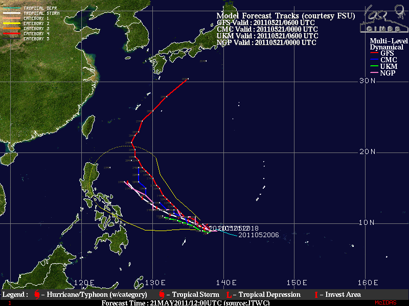
Volgens GFS wordt het geen landfall op de Filipijnen, maar buigt de orkaan net voor het eiland af. Wat niet wil zeggen dat ze daar er niets van gaan merken. De neerslag e.d. kan eventueel nog voor overlast gaan zorgen.
Onderstaand kaartje is voor donderdag, dus voor hetzelfde krijgt de Filipijnen wel een voltreffer.
Onderstaand kaartje is voor donderdag, dus voor hetzelfde krijgt de Filipijnen wel een voltreffer.
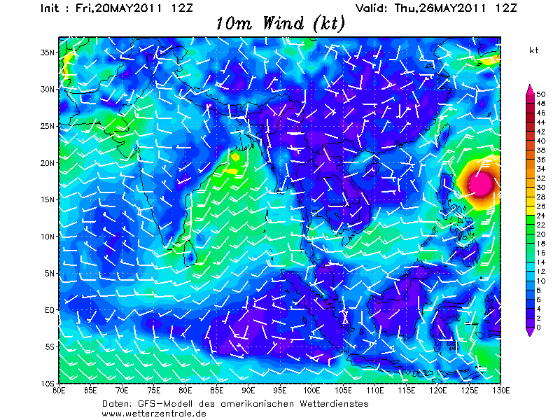
Wundergroundquote:First typhoon of 2011 coming?
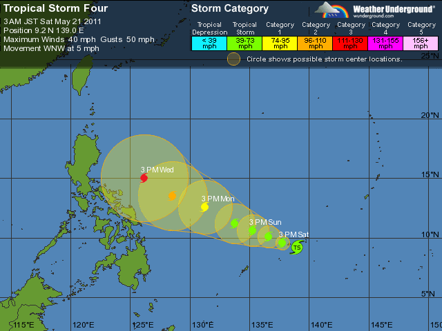
In the Northwest Pacific, Tropical Storm Four has formed, and appears poised to become the first typhoon of 2011 by early next week. The storm is expected to head west-northwest or northwest towards the Philippines. While the GFS model predicts Tropical Storm Four will miss the Philippines and recurve northwards towards Japan late next week, it is too early to be confident of this forecast.
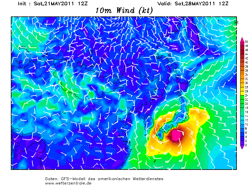
De typhoon lijkt voor de Filipijnen af te buigen richting Japan. Ik denk dat Japan geen rekening hoeft te houden met een orkaan (watertemperatuur ligt rond de 20 graden). Maar het restant kan nog wel voor de nodige overlast gaan zorgen.
GFS kaart van zaterdag 28 mei.
De orkaan ligt dan dicht bij Japan
[ Bericht 10% gewijzigd door #ANONIEM op 21-05-2011 19:37:35 ]
GFS kaart van zaterdag 28 mei.
De orkaan ligt dan dicht bij Japan
[ Bericht 10% gewijzigd door #ANONIEM op 21-05-2011 19:37:35 ]

Inderdaad ja. Dat is ook 120 uur verder, dus kan nog veel veranderen. Hoogste windsnelheid wordt geschat op 212 km/uur (categorie4). De watertemperatuur is rond de 30 graden in dit gebied.quote:
Lijkt er op dat ie toch dichter bij de kust komt dan eerst?
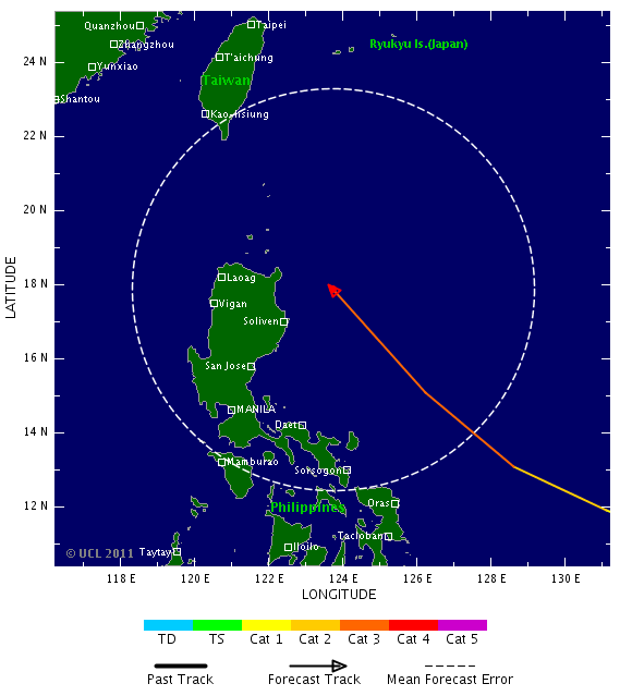
Volgens GFS trekt ie naar het noorden van de Filipijnen en is daarna Taiwan aan de beurt.quote:
inmiddels hernoemd naar Songda
Draait hij nu nog verder weg of krijgt Taiwan de volle laag?
Maar is nog ver weg.
dat kunnen ze nog wel hebben daar, een orkaantje...
Inorbit: zeg dat dan typluie triangeljosti
Beauregard: Een beetje FOK!ker laat het brood door z'n moeder smeren.
Ecosia
ek's 'n flash drive, jy's 'n floppy
Beauregard: Een beetje FOK!ker laat het brood door z'n moeder smeren.
Ecosia
ek's 'n flash drive, jy's 'n floppy
Japan bedoel je?quote:
dat kunnen ze nog wel hebben daar, een orkaantje...
Volgens de kaarten krijgt Japan ook te maken met deze orkaan. Zeewatertemperatuur is daar rond de 20 graden en dat is te koud voor een tropische orkaan. Japan krijgt wel te maken met storm en neerslag.
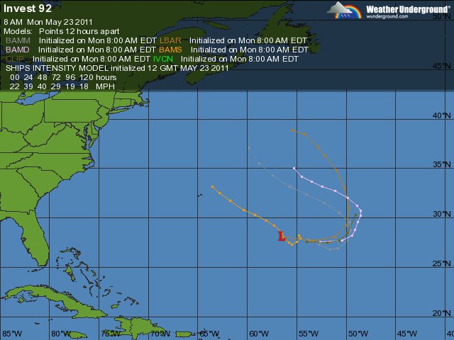
Ook in de Oost Pacific is nu een Invest. 10% kans...
Invest in de Atlantische Oceaan heeft 20% kans...
Invest in de Atlantische Oceaan heeft 20% kans...
Kans bestaat dat er zich tussen Jamaica en Centraal Amerika een tropische storing ontwikkeld ergens tussen 31 mei en 2 juni.
Wundergroundquote:an early start to hurricane season?
The Atlantic hurricane season officially begin on Wednesday, June 1, and recent computer model runs predict that we may have some early-season action in the Central Caribbean Sea to coincide with the start of this year's season. The GFS, NOGAPS, and ECMWF models have all indicated in some of their recent runs that a tropical disturbance may form between Jamaica and Central America sometime in the May 31 - June 2 time frame, as a lobe of the Eastern Pacific Intertropical Convergence Zone (ITCZ) pushes across Central America into the Caribbean. Up until now, wind shear has been too high to allow tropical storm formation in the Caribbean, due to the presence of the Subtropical Jet Stream. However, this jet is expected to push northwards over Cuba over the coming week, allowing a region of low wind shear to develop over most of the Caribbean. Water temperatures in the Central Caribbean are about 1°C above average, 29°C, which is plenty warm enough to support development of a tropical storm. The main impediment to development will probably be lack of spin, as we don't have any African tropical waves that are expected to enter the Caribbean Sea next week, to help get things spinning. Stay tuned.
Na tornado's buitengewoon zwaar orkaanseizoen in VS
Na het meest dodelijke tornadoseizoen in zestig jaar krijgen de Verenigde Staten te maken met nog meer natuurgeweld. De Amerikaanse meteorologische dienst waarschuwt voor een "buitengewoon orkaanseizoen".
Elk jaar doet de National Oceanic and Atmospheric Administration (NOAA) voorspellingen over het orkaanseizoen, dat in juni begint. Dit jaar zijn die vooruitzichten zorgwekkend. De dienst verwacht drie tot zes grote orkanen van categorie 3, 4 of 5, met windsnelheden van 180 kilometer per uur of meer.
Ook vorig jaar waarschuwde de NOAA voor orkaangeweld, maar toen kwamen de VS goed weg. "De Verenigde Staten hadden geluk", zegt Jane Lubchenco van de NOAA. "Winden duwden de meeste tropische stormen en orkanen weg van onze kust. Maar we kunnen niet op geluk blijven rekenen. We moeten voorbereid zijn, en zeker na deze voorspellingen."
Waarschuwing
De NOAA wijt de hogere kans op orkanen onder meer aan het warmere water in de Atlantische Oceaan en aan de naweeën van het klimaatfenomeen La Niña.
"De tornado's die het zuiden van het land getroffen hebben en de vele overstromingen die we deze lente gezien hebben, moeten een waarschuwing zijn dat rampen overal en op elk moment kunnen toeslaan", zegt Craig Fugate van het Amerikaans Bureau voor Rampenbestrijding. Hij drukt de inwoners van de risicogebieden op het hart om zich goed voor te bereiden en noodscenario's voor hun gezin klaar te hebben. (ips/gb)
hln
Als dat zo is zijn wij ook het bokje qua zomer 
Als die systemen onze kant op komen dan hoef ik dit jaar geen zwembad te gaan halen...
Natuurlijk kan zulke systemen voor mooi weer zorgen maar voor nu heb ik mijn twijfels hieraan..
Anyway we gaan het allemaal op de voet volgen
Als die systemen onze kant op komen dan hoef ik dit jaar geen zwembad te gaan halen...
Natuurlijk kan zulke systemen voor mooi weer zorgen maar voor nu heb ik mijn twijfels hieraan..
Anyway we gaan het allemaal op de voet volgen
Doe mee met het voorspellen van het weer!
Weekvoorspelling | Week 12 (invullen tot 16-03 - 11:59)
Maandvoorspelling Maart (Inzendingen gesloten)
Jaarvoorspelling 2025 / 2026
Weekvoorspelling | Week 12 (invullen tot 16-03 - 11:59)
Maandvoorspelling Maart (Inzendingen gesloten)
Jaarvoorspelling 2025 / 2026
Er lijkt zich inderdaad iets te ontwikkelen in de Caribische zee. In eerste instantie lijkt het niet veel voor te stellen, maar het kan een vroege start worden.
Meestal duurt het dan nog een aantal weken voordat de eerste serieuze storm ontstaat.quote:
Kans is nog steeds aanwezig dat het gebiedje in de Caribische zee iets gaat worden.
Vandaag is officieel het orkaan seizoen in de Atlantische Oceaan van start gegaan. Meestal duurt het dan nog wel een tijdje voor de eerste serieuse storm onstaat. Momenteel is er een invest ten oosten van Florida dat in de gaten gehouden wordt. Het systeem heeft nu 30% kans op een ontwikkeling tot een tropische storm en dat is erg weinig.
Accuweather heeft ook een voorspelling uitgebracht. Men voorspelt 15 tropische stormen die een naam krijgen. Hiervan gaan er 8 de orkaan status halen en 4 zullen de status krijgen van 'Major Hurricane' (cat 3 of meer).
Verder verwacht men meer impact op het vaste land dan vorig jaar.
Al een aantal dagen lijkt het erop dat er een storing gaat ontstaan in de Caribische zee. Het is afwachten wat dit gaat worden. Al groeit dit systeem niet uit tot een tropische depressie of meer, het kan nog wel voor de nodige hoeveelheden regen zorgen.
Accuweather heeft ook een voorspelling uitgebracht. Men voorspelt 15 tropische stormen die een naam krijgen. Hiervan gaan er 8 de orkaan status halen en 4 zullen de status krijgen van 'Major Hurricane' (cat 3 of meer).
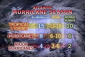
Verder verwacht men meer impact op het vaste land dan vorig jaar.
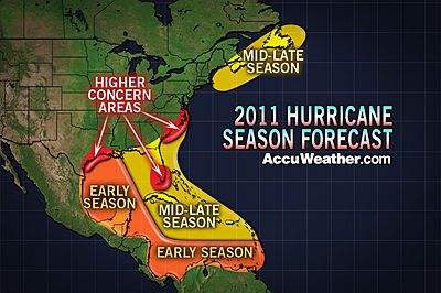
Al een aantal dagen lijkt het erop dat er een storing gaat ontstaan in de Caribische zee. Het is afwachten wat dit gaat worden. Al groeit dit systeem niet uit tot een tropische depressie of meer, het kan nog wel voor de nodige hoeveelheden regen zorgen.
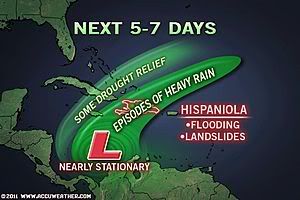
Er is nu ook een invest in de Arabische Zee (zee tussen Jemen, Oman, Pakistan Iran Verenigde Arabische Emiraten en India.).
Volgens de kaarten van GFS gaat dit systeem zich langzaam ontwikkelen en kan in eerste instantie voor overlast gaan zorgen langs de westkust van India.
Dit systeem lijkt momenteel de meeste kans te hebben om uit te gaan groeien tot een flinke storm.
Orkanen komen hier niet veel voor, het gemiddelde staat op 1 per jaar.
Verwachting orkaanseizoen 2011
Elk jaar wordt er aan het eind van de lente een verwachting opgesteld voor het komende orkaanseizoen in het Caribisch gebied en het tropische deel van de Atlantische Oceaan. Vorig jaar werd een zwaar orkaanseizoen verwacht en uiteindelijk werden 19 tropische stormen geteld. We moeten terug naar 2005 voor een nog zwaarder seizoen. Dat was overigens het jaar dat Katrina de Amerikaanse stad New Orleans trof. Inmiddels zijn de verwachtingen voor 2011 uitgegeven en vandaag behandelen we er drie. We bekijken de vooruitblik van de NOAA, WCS en de Britse weerdienst.
Afwijking in zeewatertemperatuur tussen vorig jaar en dit jaar. Het zeewater is iets minder warm waardoor tropische storingen niet zo snel tot ontwikkeling kunnen komen zoals vorig jaar het geval was. (Bron: WCS)
NOAA
De NOAA is de nationale weerdienst in Amerika en maakt elk jaar seizoensverwachtingen. In de zomerverwachting wordt ook altijd gekeken naar het komende orkaanseizoen. De NOAA verwacht een bovennormaal seizoen met 12 tot 18 tropische stormen waarvan 6 tot 10 zullen uitgroeien tot een orkaan. 3 tot 6 van deze orkanen kunnen uitgroeien tot een categorie 3, 4 of 5 orkaan. Wanneer en waar ze zullen toeslaan, is moeilijk aan te geven. Dat is bij orkanen pas op het laatste moment duidelijk. Feit is wel dat vorig jaar de Amerikaanse oostkust geluk gehad heeft. De meeste tropische stormen (in totaal ontstonden er 19) bleven op volle zee en slechts 1 orkaan (Bonnie) maakte landfall langs de oostkust. Of de orkanen dit jaar ook op ruime afstand van de kust blijven, moet nog maar blijken. Ondanks dat er iets minder stormen worden verwacht, gaat men er vanuit dat de impact voor de Amerikaanse oostkust dit jaar groter zal zijn.
Sinds 1995 zitten we in een regelmatig terugkerende situatie waarbij hogere watertemperaturen en een bepaald stromingspatroon boven het tropische deel van de Atlantische Oceaan het ontstaan van tropische stormen “makkelijker” maken. Deze cyclus duurt een aantal jaren, maar we zitten er nu dus nog middenin. Daarnaast zien we nu dat de watertemperaturen ongeveer 1 graad warmer zijn dan normaal in deze tijd van het jaar. Tenslotte is La Niña vrijwel voorbij, maar in de hogere luchtlagen is de komende tijd nog een afname van de windschering (verandering in windsterkte en – richting met de hoogte) zichtbaar zodat tropische stormen makkelijker kunnen ontstaan.
De "Tropical Cyclone Heat Potential (TCHP) op 30 april 2011 (boven) en 2010 (onder). Op basis van deze waarden verwacht WCS dat er iets minder tropische stormen ontstaan in vergelijking tot vorig jaar. Overigens kan het zijn dat de watertemperatuur de komende weken verder oploopt dan dat men nu verwacht. In dat geval kan het aantal stormen ook hoger uitkomen. (Bron: WCS)
WCS
De World Climate Service (onderdeel van de Meteo Group) verwacht ook een actief seizoen, maar niet zo actief als vorig jaar. Men verwacht 13 tot 17 tropische stormen waarvan 6 tot 9 zullen uitgroeien tot een orkaan en 3 of 4 zelfs een orkaan van de zwaardere categorie worden.
Als belangrijkste reden geeft WCS aan dat de zeewatertemperatuur hoger is dan normaal. Toch hebben recente studies aangetoond dat het niet voldoende is om enkel naar de temperatuur van het zeewateroppervlak te kijken. Een dunne laag met warm zeewater kan bij menging door wind of stroming weer heel snel afkoelen. Belangrijker is om te kijken naar de aanwezige warmte-energie in een dikkere kolom oceaanwater. De “Tropical Cyclone Heat Potential” (TCHP) was eind april in een groot deel van het Caribisch gebied (sterk) positief terwijl dat een jaar eerder niet het geval was.
Op 16 september 2010 waren er drie orkanen actief boven de Atlantische Oceaan en de Caribische zee. Het ging om Karl, Igor en Julia. (Bron: NOAA)
UKMO
De Britse weerdienst, The UK Met Office maakt sinds een paar jaar ook verwachtingen. Dat is niet omdat de restanten van tropische stormen uiteindelijk ook in Europa voor onstuimig weer kunnen zorgen, maar vanwege het simpele feit dat orkanen in de VS grote invloed hebben in de hele wereld. Denk daarbij aan de wereldvoedselmarkt en de soms snelle veranderingen in olieprijzen.
De UKMO verwacht ongeveer 13 tropische stormen met een 70% kans dat het aantal tussen 10 en 17 komt te liggen. Daarmee is de UKMO iets minder scheutig in vergelijking tot de verwachting van de NOAA en WCS. De UKMO kijkt niet alleen naar het aantal stormen, men probeert ook een beeld te krijgen van de levensduur en intensiteit van de stormen. Voor dit jaar verwacht men een Accumulated Cyclone Energy index (ACE) van 151 met een 70% kans dat de index tussen 89 tot 212 komt te liggen. Dit is ver boven het gemiddelde van 104 (gebasseerd op de periode 1980-2010).
Hoeveel tropische stormen, orkanen en zware orkanen er dit jaar uiteindelijk in de boeken worden bijgeschreven weten we pas eind november. Op dat moment is het seizoen van 2011 afgelopen al hebben we in 2005 gezien dat zelfs in december nog enkele stormen tot ontwikkeling kwamen.
Bron: Meteo Consult, NOAA, WorldClimateService, UKMO
Elk jaar wordt er aan het eind van de lente een verwachting opgesteld voor het komende orkaanseizoen in het Caribisch gebied en het tropische deel van de Atlantische Oceaan. Vorig jaar werd een zwaar orkaanseizoen verwacht en uiteindelijk werden 19 tropische stormen geteld. We moeten terug naar 2005 voor een nog zwaarder seizoen. Dat was overigens het jaar dat Katrina de Amerikaanse stad New Orleans trof. Inmiddels zijn de verwachtingen voor 2011 uitgegeven en vandaag behandelen we er drie. We bekijken de vooruitblik van de NOAA, WCS en de Britse weerdienst.
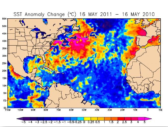
Afwijking in zeewatertemperatuur tussen vorig jaar en dit jaar. Het zeewater is iets minder warm waardoor tropische storingen niet zo snel tot ontwikkeling kunnen komen zoals vorig jaar het geval was. (Bron: WCS)
NOAA
De NOAA is de nationale weerdienst in Amerika en maakt elk jaar seizoensverwachtingen. In de zomerverwachting wordt ook altijd gekeken naar het komende orkaanseizoen. De NOAA verwacht een bovennormaal seizoen met 12 tot 18 tropische stormen waarvan 6 tot 10 zullen uitgroeien tot een orkaan. 3 tot 6 van deze orkanen kunnen uitgroeien tot een categorie 3, 4 of 5 orkaan. Wanneer en waar ze zullen toeslaan, is moeilijk aan te geven. Dat is bij orkanen pas op het laatste moment duidelijk. Feit is wel dat vorig jaar de Amerikaanse oostkust geluk gehad heeft. De meeste tropische stormen (in totaal ontstonden er 19) bleven op volle zee en slechts 1 orkaan (Bonnie) maakte landfall langs de oostkust. Of de orkanen dit jaar ook op ruime afstand van de kust blijven, moet nog maar blijken. Ondanks dat er iets minder stormen worden verwacht, gaat men er vanuit dat de impact voor de Amerikaanse oostkust dit jaar groter zal zijn.
Sinds 1995 zitten we in een regelmatig terugkerende situatie waarbij hogere watertemperaturen en een bepaald stromingspatroon boven het tropische deel van de Atlantische Oceaan het ontstaan van tropische stormen “makkelijker” maken. Deze cyclus duurt een aantal jaren, maar we zitten er nu dus nog middenin. Daarnaast zien we nu dat de watertemperaturen ongeveer 1 graad warmer zijn dan normaal in deze tijd van het jaar. Tenslotte is La Niña vrijwel voorbij, maar in de hogere luchtlagen is de komende tijd nog een afname van de windschering (verandering in windsterkte en – richting met de hoogte) zichtbaar zodat tropische stormen makkelijker kunnen ontstaan.
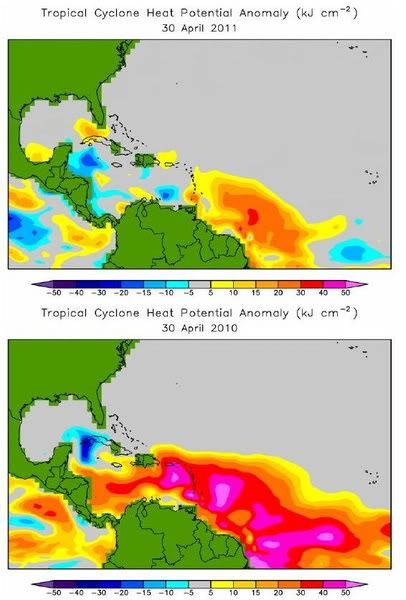
De "Tropical Cyclone Heat Potential (TCHP) op 30 april 2011 (boven) en 2010 (onder). Op basis van deze waarden verwacht WCS dat er iets minder tropische stormen ontstaan in vergelijking tot vorig jaar. Overigens kan het zijn dat de watertemperatuur de komende weken verder oploopt dan dat men nu verwacht. In dat geval kan het aantal stormen ook hoger uitkomen. (Bron: WCS)
WCS
De World Climate Service (onderdeel van de Meteo Group) verwacht ook een actief seizoen, maar niet zo actief als vorig jaar. Men verwacht 13 tot 17 tropische stormen waarvan 6 tot 9 zullen uitgroeien tot een orkaan en 3 of 4 zelfs een orkaan van de zwaardere categorie worden.
Als belangrijkste reden geeft WCS aan dat de zeewatertemperatuur hoger is dan normaal. Toch hebben recente studies aangetoond dat het niet voldoende is om enkel naar de temperatuur van het zeewateroppervlak te kijken. Een dunne laag met warm zeewater kan bij menging door wind of stroming weer heel snel afkoelen. Belangrijker is om te kijken naar de aanwezige warmte-energie in een dikkere kolom oceaanwater. De “Tropical Cyclone Heat Potential” (TCHP) was eind april in een groot deel van het Caribisch gebied (sterk) positief terwijl dat een jaar eerder niet het geval was.
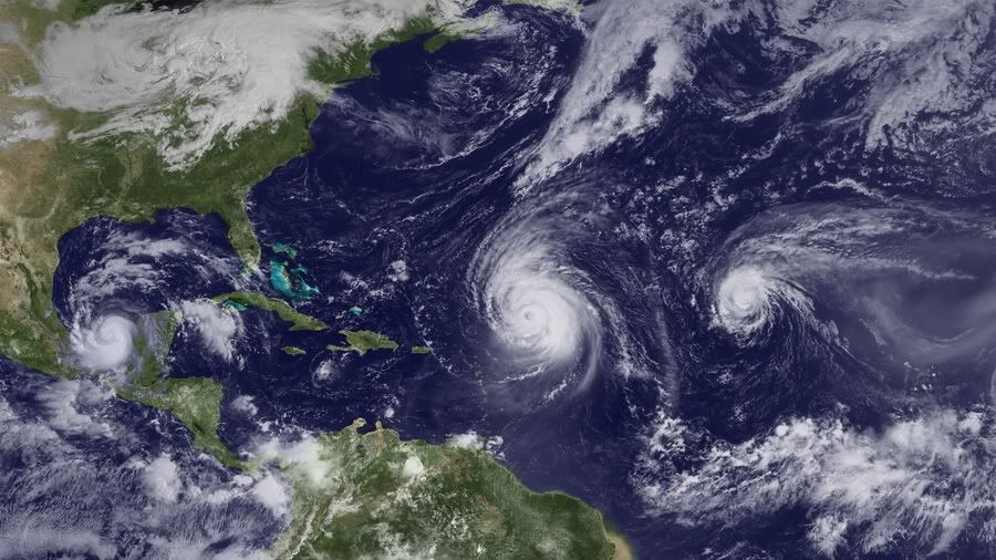
Op 16 september 2010 waren er drie orkanen actief boven de Atlantische Oceaan en de Caribische zee. Het ging om Karl, Igor en Julia. (Bron: NOAA)
UKMO
De Britse weerdienst, The UK Met Office maakt sinds een paar jaar ook verwachtingen. Dat is niet omdat de restanten van tropische stormen uiteindelijk ook in Europa voor onstuimig weer kunnen zorgen, maar vanwege het simpele feit dat orkanen in de VS grote invloed hebben in de hele wereld. Denk daarbij aan de wereldvoedselmarkt en de soms snelle veranderingen in olieprijzen.
De UKMO verwacht ongeveer 13 tropische stormen met een 70% kans dat het aantal tussen 10 en 17 komt te liggen. Daarmee is de UKMO iets minder scheutig in vergelijking tot de verwachting van de NOAA en WCS. De UKMO kijkt niet alleen naar het aantal stormen, men probeert ook een beeld te krijgen van de levensduur en intensiteit van de stormen. Voor dit jaar verwacht men een Accumulated Cyclone Energy index (ACE) van 151 met een 70% kans dat de index tussen 89 tot 212 komt te liggen. Dit is ver boven het gemiddelde van 104 (gebasseerd op de periode 1980-2010).
Hoeveel tropische stormen, orkanen en zware orkanen er dit jaar uiteindelijk in de boeken worden bijgeschreven weten we pas eind november. Op dat moment is het seizoen van 2011 afgelopen al hebben we in 2005 gezien dat zelfs in december nog enkele stormen tot ontwikkeling kwamen.
Bron: Meteo Consult, NOAA, WorldClimateService, UKMO
Tropical Cyclone Threat to Western India as Monsoon Kicks In
Torrential rain and strong winds will strike western India during the next several days as the leading edge of the Summer Monsoon spreads northward.
Westernmost India, from Kollam north to Mumbai, will have heavy rain, locally amounting to between 12 and 24 inches (about 30 to 60 cm), which could trigger significant flooding.
Low pressure helping to usher seasonal rains of the Summer, or South West, Monsoon northward will drift northward near the west coast through early next week. This low could ultimately intensify into a tropical cyclone, bringing the additional threat of damaging winds along its path.
According to the India Department of Meteorology (IMD), onset of the South West Monsoon was officially declared in the southwestern state of Kerala as of May 29. The onset thus happened a little earlier than the historical average date of June 1.
As of June 2, IMD showed further northward advance of the Monsoon into the state of Karnataka, where it also happened a few days earlier than usual.
In Kerala, normally the first of India's states to feel the full weight of the seasonal rains, rainfall has already exceeded 12 inches, or about 30 cm, in Kochi.
Super Cyclonic Storm Gonu east of Oman on June 4, 2007. NASA Image/Jeff Schmaltz
If a tropical cyclone were to emerge from the low off western India, it would in no way be unprecedented. Indeed, the month of June occasionally sees the spinning up of a cyclone over the Arabian Sea.
Perhaps the most extreme example of such a storm is that of Super Cyclonic Storm Gonu, which lived out a devastating life cycle during the first week of June 2007. Gonu clipped eastern Oman, making it the strongest known storm ever strike Arabia. Gonu also made a destructive, final landfall upon southeastern Iran.
Accuweather

Torrential rain and strong winds will strike western India during the next several days as the leading edge of the Summer Monsoon spreads northward.
Westernmost India, from Kollam north to Mumbai, will have heavy rain, locally amounting to between 12 and 24 inches (about 30 to 60 cm), which could trigger significant flooding.
Low pressure helping to usher seasonal rains of the Summer, or South West, Monsoon northward will drift northward near the west coast through early next week. This low could ultimately intensify into a tropical cyclone, bringing the additional threat of damaging winds along its path.
According to the India Department of Meteorology (IMD), onset of the South West Monsoon was officially declared in the southwestern state of Kerala as of May 29. The onset thus happened a little earlier than the historical average date of June 1.
As of June 2, IMD showed further northward advance of the Monsoon into the state of Karnataka, where it also happened a few days earlier than usual.
In Kerala, normally the first of India's states to feel the full weight of the seasonal rains, rainfall has already exceeded 12 inches, or about 30 cm, in Kochi.

Super Cyclonic Storm Gonu east of Oman on June 4, 2007. NASA Image/Jeff Schmaltz
If a tropical cyclone were to emerge from the low off western India, it would in no way be unprecedented. Indeed, the month of June occasionally sees the spinning up of a cyclone over the Arabian Sea.
Perhaps the most extreme example of such a storm is that of Super Cyclonic Storm Gonu, which lived out a devastating life cycle during the first week of June 2007. Gonu clipped eastern Oman, making it the strongest known storm ever strike Arabia. Gonu also made a destructive, final landfall upon southeastern Iran.
Accuweather
Ik ben benieuwd wat het gebied in de Arabische Zee gaat doen. GFS laat het behoorlijk intensiveren op de lange termijn. Maar elke run is weer verschillend. Op onderstaande kaarten van 10 juni is te zien dat de cycloon voor de kust van Oman ligt.
In 2007 werd dit gebied getroffen door de cycloon Gonu. In Wikipedia is te lezen dat dit de zwaarste tropische cycloon was die ooit in de Arabische Zee is waargenomen en samen met een andere tropische cycloon de zwaarste die ooit in het hele bassin van de noordelijke Indische Oceaan is waargenomen.
Het is afwachten hoe deze cycloon zich gaat ontwikkelen.
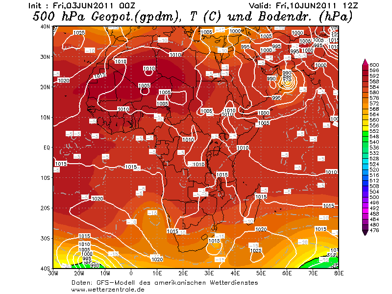
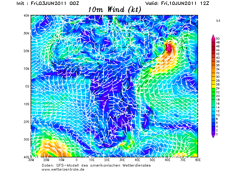
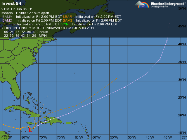
Invest in de Caribische zee is nu 30%
quote:THERE HAS BEEN LITTLE CHANGE TO THUNDERSTORM ACTIVITY ASSOCIATED
WITH A BROAD AREA OF LOW PRESSURE CENTERED ROUGHLY A HUNDRED MILES
SOUTH OF JAMAICA. ENVIRONMENTAL CONDITIONS ARE GENERALLY CONDUCIVE
FOR SOME DEVELOPMENT...AND THERE IS A MEDIUM CHANCE...30 PERCENT...
OF THIS SYSTEM BECOMING A TROPICAL CYCLONE DURING THE NEXT 48
HOURS. HEAVY RAINS COULD CAUSE FLASH FLOODING AND MUD SLIDES OVER
PORTIONS OF HAITI...THE DOMINICAN REPUBLIC...JAMAICA...AND EXTREME
SOUTHEASTERN CUBA OVER THE NEXT COUPLE OF DAYS AS THE LOW REMAINS
NEARLY STATIONARY.
Dat gebied in de Arabische zee lijkt flink te gaan activeren na maandag. Dat kan weleens gaan uitgroeien tot een zware categorie en trekt recht op Oman af. Het is wel lange termijn, maar keert steeds weer terug in de kaarten van GFS.
Afwachten inderdaad... Ze komen niet vaak voor daar. Misschien dat ze wat piratenbootjes laten omslaan
Zat me net af te vragen waarom ze het altijd invest 93 en 94 noemen daar in de Atlantic... ik heb het ooit geweten maar weet het niet meer, Ik word oud
Zat me net af te vragen waarom ze het altijd invest 93 en 94 noemen daar in de Atlantic... ik heb het ooit geweten maar weet het niet meer, Ik word oud
Hoezo altijd?quote:
Afwachten inderdaad... Ze komen niet vaak voor daar. Misschien dat ze wat piratenbootjes laten omslaan
Zat me net af te vragen waarom ze het altijd invest 93 en 94 noemen daar in de Atlantic... ik heb het ooit geweten maar weet het niet meer, Ik word oud
Elk seizoen begint bij invest 90... Iedereen keer waneer er een gebied komt dat mogelijk een depressie kan worden krijgt dan een nieuwe nummer 91, 92, 93, 94, tot invest 99L.quote:
Volgens mij als ze eenmaal weg zijn en er duiken nieuwe op noemen ze ze ook weer invest 93 of 94 ?
Daarna begint het gewoon weer opnieuw. Komt er naar invest 99L weer een nieuw gebied dan wordt dat weer invest 90.
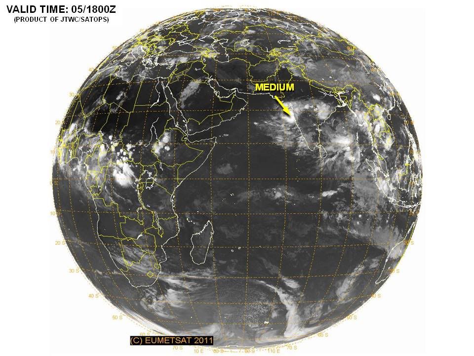
Gebied in de Oost Pacific is nu opgehoogd naar 90%. Grote kans dat dit dan de eerste storm gaat worden hier. De eerste naam is Adrian.
In de Atlantische Oceaan is de invest opgehoogd naar 40%. Er is een kans dat dit Arlene gaat worden.
In de Atlantische Oceaan is de invest opgehoogd naar 40%. Er is een kans dat dit Arlene gaat worden.
quote:Tropics Activating in Both Caribbean, East Pacific
"The formation of the first named storm in both...basins in the same week would be rather unusual."
The first depression or named storm of this year may not just come to life in the Caribbean this week, but also the eastern Pacific Ocean.
The AccuWeather.com Hurricane Center is busy as the workweek begins, closely monitoring two areas of low pressure for tropical development.
One low is located in the central Caribbean, roughly 175 miles south of Grand Cayman. The other is spinning about 450 miles south of Acapulco, Mexico, in the eastern Pacific.
Both lows have become better organized over the past 36 hours as each churns over warm water.
Due to being in an environment that is more conducive to development, the low in the eastern Pacific will likely win the race and become a tropical depression before the low in the Caribbean.
The eastern Pacific low could strengthen into a depression within the next 24 hours, then should further intensify into Tropical Storm Adrian. Latest computer models even show the low reaching hurricane strength.
The projected path of the strengthening low keeps it over the open waters of the eastern Pacific. However, a track toward the western tip of central Mexico cannot be ruled out.
As wind shear (strong winds high in the atmosphere) lessens, the low in the Caribbean may eventually follow suit and strengthen into a tropical depression this week.
If the low can then continue to strengthen, it would acquire the name "Arlene."
At this point, a range of solutions exists as to where the low will track this week. Some signs point toward the low heading into the south-central Gulf of Mexico, while a track directed at either eastern Cuba or Hispaniola is possible.
Regardless of what the future holds for the low, flooding rain and mudslides poses an immediate danger to Jamaica, southeastern Cuba and Hispaniola.
The formation of the first named storm in both the Atlantic and Eastern Pacific basins in the same week would be rather unusual.
On average, June 9 is when the first tropical storm is named in the Eastern Pacific. In the Atlantic, that date is July 10.
bron: Accuweather
50% inmiddelsquote:
In de Atlantische Oceaan is de invest opgehoogd naar 40%. Er is een kans dat dit Arlene gaat worden.
[..]
quote:Evacuaties door noodweer in Dominicaanse Republiek
AMSTERDAM - Meer dan vierduizend mensen zijn in de Dominicaanse Republiek geëvacueerd vanwege noodweer ten zuiden van Jamaica. Hierdoor wordt de Dominicaanse Republiek geteisterd door zware regenbuien.
Twaalf huizen zijn door overstromingen vernield. Nog eens 540 woningen staan blank. Ook in Haïti, Jamaica en Puerto Rico leidde het noodweer tot overstromingen.
De afgelopen dagen zijn er in de Dominicaanse Republiek één en in Haïti twee doden gevallen.
nu.nl
[ Bericht 5% gewijzigd door #ANONIEM op 06-06-2011 22:20:52 ]
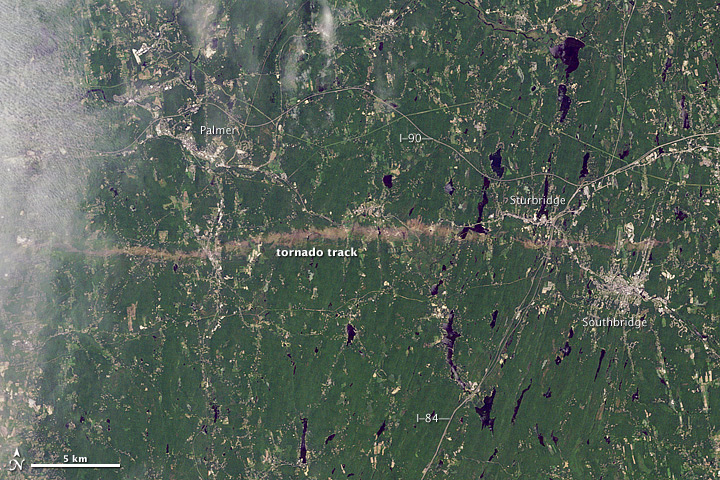
Inorbit: zeg dat dan typluie triangeljosti
Beauregard: Een beetje FOK!ker laat het brood door z'n moeder smeren.
Ecosia
ek's 'n flash drive, jy's 'n floppy
Beauregard: Een beetje FOK!ker laat het brood door z'n moeder smeren.
Ecosia
ek's 'n flash drive, jy's 'n floppy
dan verplaats je hem toch?quote:
Inorbit: zeg dat dan typluie triangeljosti
Beauregard: Een beetje FOK!ker laat het brood door z'n moeder smeren.
Ecosia
ek's 'n flash drive, jy's 'n floppy
Beauregard: Een beetje FOK!ker laat het brood door z'n moeder smeren.
Ecosia
ek's 'n flash drive, jy's 'n floppy
De eerste orkaan in de oost pacific zit er aan te komen.
Het is nu nog een tropische depressie. Op de schaal van beaufort zal het nu amper een windkracht 7 halen. Naar verwachting zal het vrijdag een orkaan zijn en geen bedreiging vormen voor land.
Het is nu nog een tropische depressie. Op de schaal van beaufort zal het nu amper een windkracht 7 halen. Naar verwachting zal het vrijdag een orkaan zijn en geen bedreiging vormen voor land.